
 California Highways:
Click here for a key to the symbols used. An explanation of acronyms may be found at the bottom of the page.
 Routing
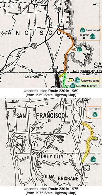 FromRoute 101 near the south city limits of San Francisco to Route 280 in San
Francisco.
FromRoute 101 near the south city limits of San Francisco to Route 280 in San
Francisco.
Notwithstanding the provisions of Section 89 of Chapter 1062 of the Statutes of 1959, construction of all or any portion of Route 230 may be commenced at any time, if the City and County of San Francisco has conveyed or does convey to the State of California, without charge, all real property presently acquired by it for the construction of such route or portion thereof.
 Post 1964 Signage History
▸In 1963, this route was defined as “Route 101 near the south city limits of San Francisco to Route 87 in San Francisco. Notwithstanding the provisions of Section 89 of Chapter 1062 of the Statutes of 1959, construction of all or any portion of Route 230 may be commenced at any time, if the City and County of San Francisco has conveyed or does convey to the State of California, without charge, all real property presently acquired by it for the construction of such route or portion thereof.”
In 1964, the California Highway Commission adopted freeway segments of
Route 230 and Route 87 between US 101-Army Street as the Hunters Point
Freeway. 1968 Legislative Chapter 282 swapped the terminus of I-280
and moved it east to end at the Embarcadero Freeway. The realignment
of I-280 led to Route 82 being truncated to US 101. Route 87 was
truncated to a northern terminus at I-280.
(Source: Gribblenation Blog (Tom Fearer), "California State Route 230 and the planned Hunters Point Freeway", 10/22/2023)
▸In 1970, Chapter 1473 extended the routing “…to Route 280 in San Francisco.” This was done by transfer from Route 87, when the portion of former Route 87 from Route 230 to Route 280 was transferred to Route 230 (this might have been the Southern Crossing approach). This was a proposed route and a route was adopted, but the adoption was rescinded in October 1976 . It was supposed to run from Route 101 south of Candlestick Park, over the SF Bay, north past the east side of Candlestick, and ending at the Hunter's Point district of San Francisco. This was supposed be the link for the proposed Southern Crossing bridge over the SF Bay. The current routing is undetermined. It might have run along the Hunter's Point expressway. More information on the Southern Crossing may be found in the entry for I-380.
The California Highway Commission cancelled the adopted routing of the
Hunters Point Freeway during October 1976. Despite the alignment
adoption of the Hunters Point Freeway being cancelled the legislative
definition of Route 230 was never deleted.
(Source: Gribblenation Blog (Tom Fearer), "California State Route 230 and the planned Hunters Point Freeway", 10/22/2023)
 Pre 1964 Signage History
This was part of proposed LRN 289, defined in 1959. Portions were part of LRN 253.
These segments were adopted by 1959 Legislature (Legislative Chapter
1062) as LRN 289 and LRN 253. The original definition of LRN 289 was:
(Source: Gribblenation Blog (Tom Fearer), "California State Route 230 and the planned Hunters Point Freeway", 10/22/2023)
"easterly of the Bayshore Freeway from San Jose to the highway described in subdivision (a) of Section 553.1, the Hunters Point Freeway"
The initial definition of LRN 253 was:
1959 Legislative Chapter 1882 added the following condition to LRN 253:
"Construction on either portion of LRN 253 described in subdivisions (a) and (b) may be commenced when the City and County San Francisco has acquired all rights of way necessary for construction of such portion and has conveyed these rights of to the State of California for highway purposes."
In 1960, LRN 253 was described as a corridor designed to provide a
connection between the Southern Freeway, US 101 (the Bayshore Freeway) and
the Embarcadero Freeway. Construction could proceed when the city of
San Francisco acquired the necessary right-of-way. Also in 1960, the
California Highway Commission adapted a route for LRN 253 as an extension
of the Southern Freeway between the Bayshore Freeway and Alemany
Boulevard. The northern part of the Hunters Point Freeway was initially
conceived as the landing point for the western end of the fourth iteration
of the proposed Southern Crossing (1954-1958). The fourth iteration
of the Southern Crossing would have included a 40,730-foot-long bridge
across San Francisco Bay.
(Source: Gribblenation Blog (Tom Fearer), "California State Route 230 and the planned Hunters Point Freeway", 10/22/2023)
1961 Legislative Chapter 1010 altered the construction amendment of LRN 253: "Notwithstanding the provision of Section 89 of Chapter 1062 of the
Statutes of 1959, construction of any or all portions of LRN 253 may be
commenced at any time, if the City and County of San Francisco has
conveyed or does convey to the State of California, without charge, all
real property presently acquired by it for the construction of such route
or portion thereof"
(Source: Gribblenation Blog (Tom Fearer), "California State Route 230 and the planned Hunters Point Freeway", 10/22/2023)
 In January 1964, it was reported that (after a long
fight), the State Highway Commission adopted "Route C" for the Hunters
Point Freeway (LRN 289, future Route 87, later Route 230). Engineers had
proposed a shorter and $5 million cheaper route, but that route would have
uprooted hundreds of people in the Bay View District. It was noted that
the approved route runs for the most part through undeveloped and
industrial land, is 4.6 mi long, and will be a 4 and 6 lane highway, and
cost $49.8 million. It was never constructed.
In January 1964, it was reported that (after a long
fight), the State Highway Commission adopted "Route C" for the Hunters
Point Freeway (LRN 289, future Route 87, later Route 230). Engineers had
proposed a shorter and $5 million cheaper route, but that route would have
uprooted hundreds of people in the Bay View District. It was noted that
the approved route runs for the most part through undeveloped and
industrial land, is 4.6 mi long, and will be a 4 and 6 lane highway, and
cost $49.8 million. It was never constructed.
(Source: The San Francisco Examiner, 1/26/1964, via Joel Windmiller,
4/26/2023)
 Freeway
[SHC 253.1] Entire route. Added to the Freeway and Expressway system in 1959. The freeway route adoption was rescinded effective 10/21/1976.
 Status
This routing is unconstructed. There is no traversable local road equivalent.
 Naming
Named for the Hunters Point Naval Shipyard, which the routing passed by. Hunters Point
derives its name from the Hunters family, who lived on the San Francisco
Bay in the 1800s. In 1870, the area was established as a commercial
shipyard and in 1941 was acquired by the Navy, days before the Japanese
attack on Pearl Harbor. Hunters Point Naval Shipyard is located on 638
acres of waterfront. In the 1950's the base employed 8,500 civilians.
Prior to decommissioning in 1974, the shipyard was a Navy repair station.
(Name information: Shipyard Artists)
 Other WWW Links
 Statistics
Overall statistics for Route 230:
 Pre-1964 Legislative Route
In 1947 (1st Ex Session), Chapter 13 defined LRN 230 as “[LRN 172] to [LRN 173] via Indiana Street in Los Angeles County”.
This ran from LRN 172 (3rd St/US 60) to LRN 173 (Olympic, later Route 26, later I-10) via Indiana Street in Los Angeles County. In 1957, when LRN 173 was rerouted from Olympic up Soto to the new Santa Ana Freeway, LRN 230 was extended along Olympic between Soto and Indiana.
The portion along Indiana St. was Route 165 between 1964 and 1965.
© 1996-2024 Daniel P. Faigin.
Maintained by: Daniel P. Faigin
<webmaster@cahighways.org>.
 Route 229
 Route 231