
 California Highways:
Click here for a key to the symbols used. An explanation of acronyms may be found at the bottom of the page.
 Routing
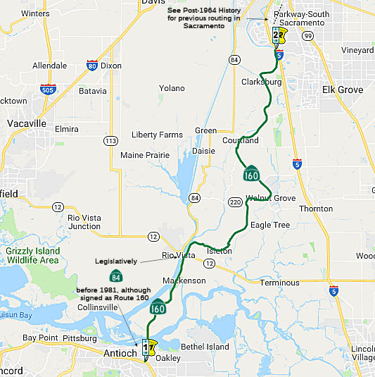 Route 4 near Antioch to the southern city limits of Sacramento.
 Post 1964 Signage History
▸In 1963, Route 160 was defined as "Route 84 near Rio Vista to Route 80 near North Sacramento via Sacramento."
▸In 1968, Chapter 282 changed the terminus of the route: "…
to Route 80 near North Sacramento via Sacramento."
▸In 1976, Chapter 1354 changed "Route 84" to "Route 12".
▸In 1981, Chapter 292 extended the route and corrected the
references to reflect the change of I-80's routing: "(a) Route 4 near
Antioch to Route 12 near Rio Vista. (b) Route 12 near Rio Vista to
Route 80 near North Sacramento Route 51 via
Sacramento." This change reflected the transfer of the portion from Route 4 to Route 12 from Route 84.
▸In 1984, Chapter 409 recombined the segments, making segment (a) "Route 4 near Antioch to Route 51 in Sacramento." Note that although until 1981 Route 160 was legislatively defined to start at Route 12 in Rio Vista, in actuality, Route 160 has always begun (signed) at Route 4 in Antioch. This means that while the Antioch Bridge may have been legislatively Route 84 from 1964-1981, it always was part of signed Route 160.
▸In 1999, Senate Bill 803, Chapter 172, authorized the California Transportation Commission to relinquish any portion of Route 160 in Sacramento County between PM 35.0 and PM 47.0 (i.e., the surface street portion) to the containing city upon request, but kept the definition of the route as ending at Route 51 in Sacramento. As of November 2001, this segment (from the American River Bridge to 3/4 mile north of the town of Freeport) had been decomissioned, and according to reports in February 2002, officially relinquished. The state removed the shield on the overhead signs on US 50 in 2004.
▸In 2003, Assembly Bill 1717, Chapter 525, officially truncated the route to "(a) Route 160 is from Route 4 near Antioch to the southern city limits of Sacramento. (b) The relinquished former portion of Route 160 within the City of Sacramento is not a state highway and is not eligible for adoption under Section 81." This inadvertanly deleted the portion of the route in North Sacramento.
▸In 2010, SB 1318, Chapter 421, 9/29/10, corrected the 2003 mistake by adding a new second segment N of the American River. The previous definition was only: "Route 4 near Antioch to the southern city limits of Sacramento."
For years, the Meadowview Road exit was signed from I-5 as access to
Route 160; while the new Cosumnes River Boulevard exit connects more
directly to Route 160 in Freeport, there is not any signage there that
informs of the nearby state route.
(Source: Chris Sampang on AARoads, "Re: CA 160", 7/25/2019)
Until relinquishment, within Sacramento, the route ran along Freeport Blvd, Broadway, the 15th/16th Street pair,. At H Street, the pairs diverged, with SB running along H Street and 12th Street to the 12th/16th Street Bridge and the North Sacramento Freeway. NB remained on 16th Street to the bridge and the North Sacramento Freeway. The North Sacramento Freeway is discussed in (b).
In 1977, Freeport was turned into a one-way street N of 4th
Ave. At that time, the routing was changed to use a couplet of Freeport St
(SB) and 21st Street (NB) to Broadway. The conversion of
Freeport and 21st back to two-way operation was first proposed in 2003, a few months after that section of Route 160 was
relinquished to the city. Prior to 2011, the configuration was two
southbound lanes along Freeport between Broadway and 21st
Street/4th Avenue, and three northbound lanes along 21st
between Freeport/4th Avenue and Broadway.
(Source: Chris Sampang on AARoads, "Re: CA 160", 7/26/2019)
The original reason for the northwest "jog" of Freeport Blvd at 4th
Avenue. (variously LRN 11, Pre-1964 Route 24, and lastly Route 160) was
the rather nasty RR grade crossing (original WP main line) just north of
the "jog" point along South 21st Street. The old WP yard was
about a half-mile south of that grade crossing, and trains had a tendency
to be stopped there, blocking traffic. Early on that didn't sit well with
D3, so they cobbled up the Freeport extension along South 19th
Street, a residential 2-lane facility, as far north as Broadway. Besides,
the very shallow angle of the crossing (about 15 degrees) added to the
fact that the track was up on a berm, and traffic didn't have a terribly
good view of the tracks in pre-crossing-gate days -- combined to make an
extremely unsafe condition along a heavily-traveled artery. Thus the
alignment change, which lasted through the two-way couplet days; with the
addition of crossing gates in the '50's, Caltrans eventually elected to go
along with the City of Sacramento's couplet plans by the '70's, after the
WP yard was downgraded and their switching operations moved south to
Stockton.
(Source: Scott Parker on AARoads, "Re: CA 160", 7/29/2019)
The Sacramento light rail line along 12th Street (former Route 160 and before that, former US 99E/US 40) actually predates the
relinquishment by about 15 years, being installed ca. 1987.
(Source: Chris Sampang on AARoads, "Re: CA 160", 7/25/2019)
 Pre 1964 Signage History
The portion of this route from Antioch to Broadway in Sacramento, via Freeport Boulevard and River Road was LRN 11, defined in 1933, and was originally signed as part of Sign Route 24 starting in 1935. It was renumbered as Route 160 in the 1964 renumbering.
 In 1956, the San Francisco Examiner published the proposed lengthening of the freeway along
part of Sign Route 24 (Route 160) along Neroly Avenue to the Antioch
Bridge. This would connect to the co-signed Sign Route 4/Sign Route 24
(Route 4) routing that had been approved in 1949. As the map shows, the
pre-freeway routings were along A Street, 18th Street, Main
Street, and Empire Avenue for Sign Route 4, and Neroly Avenue and
Bridgehead Avenue for Sign Route 24 (Route 160).
In 1956, the San Francisco Examiner published the proposed lengthening of the freeway along
part of Sign Route 24 (Route 160) along Neroly Avenue to the Antioch
Bridge. This would connect to the co-signed Sign Route 4/Sign Route 24
(Route 4) routing that had been approved in 1949. As the map shows, the
pre-freeway routings were along A Street, 18th Street, Main
Street, and Empire Avenue for Sign Route 4, and Neroly Avenue and
Bridgehead Avenue for Sign Route 24 (Route 160).
(Source: San Francisco Examiner, 12/9/1956 via Joel Windmiller,
4/26/2023)
Antioch Bridge (~ SAC L0.033)
 The original Antioch bridge was built in 1926. It was
4,640 ft long. At the time it was constructed, it was the largest highway
bridge ever constructed in California. The route to Rio Vista (i.e.,
future Sign Route 24, current Route 160) was originally a county
road. There were also plans (in 1926) to install a bridge at Three
Mile Slough; that bridge was to be moved from Grand Island. The original
bridge contained 2,000 tons of structural steel, and 500 tons of
reinforcing steel. There were two navigation openings that were 320' wide
with a maximum vertical clearance of 70' above high tide. One of the spans
was a "lift span", which lifted up between the two towers. The
original structure was completed in 1926 by the American Toll Bridge
Company (Aven Hanford and Oscar Klatt), who went on to build the original
span of the Carquinez Bridge. The bridge was opened on 1 January 1926 as a
connecting link on the coast-to-coast Victory Highway. Hanford and Klatt,
officials with the Rodeo-Vallejo Ferry Company, had organized the American
Toll Bridge Company in 1923, which built the bridge at a cost of greater
than US $2,000,000 (equivalent to $29,410,000 in 2018).
The original Antioch bridge was built in 1926. It was
4,640 ft long. At the time it was constructed, it was the largest highway
bridge ever constructed in California. The route to Rio Vista (i.e.,
future Sign Route 24, current Route 160) was originally a county
road. There were also plans (in 1926) to install a bridge at Three
Mile Slough; that bridge was to be moved from Grand Island. The original
bridge contained 2,000 tons of structural steel, and 500 tons of
reinforcing steel. There were two navigation openings that were 320' wide
with a maximum vertical clearance of 70' above high tide. One of the spans
was a "lift span", which lifted up between the two towers. The
original structure was completed in 1926 by the American Toll Bridge
Company (Aven Hanford and Oscar Klatt), who went on to build the original
span of the Carquinez Bridge. The bridge was opened on 1 January 1926 as a
connecting link on the coast-to-coast Victory Highway. Hanford and Klatt,
officials with the Rodeo-Vallejo Ferry Company, had organized the American
Toll Bridge Company in 1923, which built the bridge at a cost of greater
than US $2,000,000 (equivalent to $29,410,000 in 2018).
(Source: Joel Windmiller, 2/4/2023)
The current Antioch bridge was completed and opened to traffic in 1978. It measures 1.8 miles (2.9 km). According to Wikipedia, the original lift span bridge was plagued with problems throughout its lifetime. Heavy traffic could cross it at no more than 15 mph, and its narrow shipping canal led to collisions in 1958, 1963 and 1970. The Antioch Bridge is one of only three (the others being the Carquinez and Dumbarton bridges) state-owned toll bridges that currently have bicycle and pedestrian access.
In October 2023, the Isleton Bridge (SAC 005.86, Bridge № 24-0051)
celebrated its 100th anniversary. On Oct. 27, 1923, the Isleton
Chamber of Commerce held a dedication ceremony to open the 624-foot,
two-lane bridge serving the surrounding communities. The Isleton Bridge is
a double-leafed draw bridge with steel roadway sections that draw up and
away from each other to allow ships to pass. This bridge type may also be
referred to as bascule, from the French balance scale, because the bridge
uses counterweights to aid in the opening and closing of the moveable
sections.
(Source: Bay Link Blog, 11/15/2023)
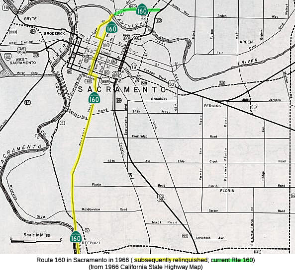
The portion from Freeport to 16th was LRN 4, and was signed as Route 24, US 50/US 99 (to 1954), and US 99W (1954-1964). The portion from 16th Street in Sacramento north from Broadway to N Street, Capitol Avenue was LRN 4 and was signed as US 50/US 99 (to 1954), and US 99W (1954-1964). The remainder of the route was LRN 3 (defined in 1909), and was signed as follows: the segment from 15th/16th Street north of Capitol Avenue to the 16th Street Bridge was signed as US 40 (to 1964) and US 99E (to 1954); the segment from 12th Street and F Street to 15th Street was signed as US 40 (1950s-1964); and the segment from the 16th Street Bridge and North Sacramento Freeway was signed as US 40 (to 1964) and US 99E (1946-1954). These segments were part of Route 160 (Sign Route 24) until 1999, when Senate Bill 803, Chapter 172, authorized the California Transportation Commission to relinquish any portion of Route 160 in Sacramento County between PM 35.0 and PM 47.0 (i.e., the surface street portion) to the containing city upon request, but kept the definition of the route as ending at Route 51 in Sacramento. As of November 2001, this segment (from the American River Bridge to 3/4 mile north of the town of Freeport) had been decommissioned, and according to reports in February 2002, officially relinquished.
Note: A 1939 map shows Route 160 along Highland Blvd between Cahuenga Blvd and Santa Monica Blvd in Los Angeles. This route was LRN 160. Sign Route 160 was not defined in the 1934 initial set of state signed routes.
 Status
Route 160 is constructed to freeway standards from Route 4 near Antioch to the Antioch Toll Booth.
Antioch Bridge / Route 4 Connectors (~ CC L0.3L to CC 1.178)
In April 2012, it was reported that a project to build a freeway connector ramp between the Route 4 bypass and the Antioch Bridge is getting about $1.4 million in local developer funds. The additional funds will widen the bridge structure of the ramp from the bypass north to Route 160, allowing BART trains to pass underneath someday. The ramp, located on the Oakley-Antioch border, is estimated to cost about $50 million. The design change adds a sliver of road to the northeast of the ramp and improves the bridge's geometry for the BART tracks. Since the Route 4 bypass opened in 2008, drivers headed north toward Sacramento County have had to cut through Oakley side streets or drive two miles west to the Hillcrest Avenue exit, leave the freeway and enter in the other direction to cross the bridge. The overpass, which is funded by leftover money from a seismic retrofit of the bridge, will take about three years to complete and could start by spring 2014.
In February 2016, it was reported that a pair of ramps,
one connecting westbound Route 4 to Route 160 leading to the bridge and
the other connecting southbound Route 160 to eastbound Route 4, were
opened in late February. The ramps will eliminate the need for motorists
heading to and from eastern Contra Costa to the bridge to drive about a
mile farther west to make U-turns at the Hillcrest Avenue interchange in
Antioch. The connector ramps project is also adding new lanes in both
directions on Route 160 from the Route 160/Route 4 interchange north to
the interchange at East 18th and Main streets. The expansion of
the Route 160/Route 4 interchange will allow room for the BART extension
in the median of Route 4. The project, which includes new sound wall
extensions and new retaining walls, was funded by $50 million from the Bay
Area Toll Authority. The ramps are a part of the larger $1.3 billion
project led by the CCTA and other agencies to widen Route 4 between
Pittsburg and Antioch from two lanes in each direction to four lanes
beginning at Loveridge Road and extend BART along the corridor from the
Pittsburg/Bay Point station to Antioch.
(Source: East Bay Times,2/29/2016)
Antioch Bridge Retrofit Project (~ CC 1.089 to SAC L0.325)
According to the San Jose Mercury News, there are plans in early 2009 to raise tolls on the Antioch Bridge, likely $1, and likely to be applied to carpoolers as well. They may also add congestion pricing. This is being done to help support the cost of retrofitting the Dumbarton and Antioch spans for earthquake improvements. In February 2010, the toll increased to $5 at all times on the Dumbarton, San Mateo, Richmond-San Rafael, Carquinez, Benicia-Martinez and Antioch bridges. In July 2010, the toll will be extended to carpoolers, who will pay $2.50.
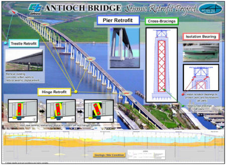 In July 2011, it was reported there is a plan to retrofit the Antioch Bridge.
The current 1.8 mile-long steel plate girder bridge was opened in 1978
with one lane in each direction. The current retrofit strategy for the
bridge includes relatively minor modifications to the approach structure
on Sherman Island, the addition of isolation bearings and strengthening of
the columns and hinge retrofits. Bids for the retrofit contract were
opened on March 10, 2010. The contract was awarded to California
Engineering Contractors, Inc. on April 22, 2010. The awarded contract was
significantly less than the engineer's estimate for the work and has
resulted in a significant cost forecast reduction.
In July 2011, it was reported there is a plan to retrofit the Antioch Bridge.
The current 1.8 mile-long steel plate girder bridge was opened in 1978
with one lane in each direction. The current retrofit strategy for the
bridge includes relatively minor modifications to the approach structure
on Sherman Island, the addition of isolation bearings and strengthening of
the columns and hinge retrofits. Bids for the retrofit contract were
opened on March 10, 2010. The contract was awarded to California
Engineering Contractors, Inc. on April 22, 2010. The awarded contract was
significantly less than the engineer's estimate for the work and has
resulted in a significant cost forecast reduction.
In April 2012, it was reported that the seismic
retrofitting project had completed. At the peak of the project, as many as
75 workers were out on the bridge every day, standing on huge scaffoldings
along the bridge's 150-foot piers or on hanging platforms beneath its
roadway deck. They installed massive bearings to let the deck of the
bridge move independently of the piers, with the idea that this will
prevent cracking or breaking in a quake. The deck itself was fitted with
expansion joints that will let it stretch longer in a quake rather that
snapping in pieces. The project was paid for with bridge toll revenue as
part of a broader retrofit program funded by toll hikes that took effect
in 2010. The contractor, Pleasanton-based California Engineering
Contractors Inc., took great care to protect local wildlife throughout the
retrofit. For example, they installed owl nesting posts nearby, in hopes
owls would lay their eggs there. If an owl laid eggs on the bridge, work
stopped for 250 feet inboth directions until the owlets hatched and could
fly away, which could stall portions of the project for up to three
months.
(Source: Contra Costa Times, 4/17/2012)
Antioch Bridge Tolls
In September 2019, it was reported that the
Metropolitan Transportation Commission gave the green light on a $4
million contract with a consultant for an all-electronic tolling system
for all bay area bridges, except the Golden Gate which is its own district
and has already gone cashless.. Drivers must pay with FasTrak only. For
those without FasTrak, cameras will capture your license plate and you'll
get a bill in the mall. The commission said it will save drivers time and
the agency money. Drivers won't have to slow down to squeeze through a
toll booth. Toll booths will be removed. The commission anticipates
realistically it could take up to five years for the system to go into
effect. The Carquinez Bridge will likely be the first to go cashless. MTC
said engineers say it's a good test bed to move faster on the others. The
Bay Bridge will be likely be last since it's the busiest. The toll
authority first authorized the move to all-electronic, open road tolling
in December 2018. The consultants jsut approved will be responsible for
developing the toll system’s specifications, providing oversight of
the program’s implementation, reviewing design plans, and help to
develop policies for all-electronic tolling. Bridges under the purview of
the toll authority include the Antioch Bridge, Benicia-Martinez Bridge,
Carquinez Bridge, Dumbarton Bridge, Richmond-San Rafael Bridge, San
Mateo-Hayward Bridge and the San Francisco-Oakland Bay Bridge.
(Source: KTVU, 9/1/2019; SFExaminer,
9/4/2019)
Sacramento River Delta Movable Bridge Repairs (SAC L006.98 to SAC 19.76)
In March 2019, the CTC was informed about the following
emergency allocation: $700,000 Sacramento 03-Sac-160 L7.0 (L006.98). Route 160 Near Rio Vista at Three Mile Slough Bridge No. 24-0121. On December 3,
2018 the department discovered a kink in the wire rope used to lift the
Three Mile Slough Bridge. After additional investigation it was noticed
that the kink damaged the rope guide and push bar. This emergency measure
resulted in the draw bridge being inoperable and the US Coast Guard was
notified. This project will replace the mechanical damaged components. The
project was also added into the SHOPP: 03-Sac-160 L7.0 PPNO 5874 Proj. ID
0319000074. Route 160 Near Rio Vista, at Three Mile Slough Bridge No.
24-0121. Repair mechanical components of bridge. Total est cost. $700,000.
(Source: March 2019 CTC Minutes, Agenda Item
2.5f.(1) Item 8; March 2019 CTC Minutes Agenda Item 2.1a.(1) Item 7)
In Summer 2019, it was reported that emergency repairs
had taken place at the Isleton Bridge, SAC 005.86, Bridge № 24-0051.
This is one of five bridges deemed to be at the greatest risk of operating
failure. In January 2019, the Isleton Bridge was closed to repair a bridge
locking mechanism. Additional repairs are scheduled for the movable
bridges in the delta. Specifically, the movable bridges in the Delta at
Three-Mile Slough (opened in 1949), Isleton (1923), Paintersville (1923)
[SAC 020.87, Bridge 24-0053] and Steamboat Slough (1924) [SAC 019.76,
Bridge 24-0052] are scheduled for $20 million in major
electrical/mechanical upgrades and seismic retrofit at Paintersville
through a director’s order, issued to complete time-sensitive,
critical repairs. Isleton, like Paintersville and Steamboat Slough, are
Bascule bridges, are the earliest form of movable bridge. They have one or
two sections, called leafs, that open on a hinge, or trunnion, that pulls
the leaf up to allow vessels to pass. The bascule design features concrete
counterweights. Bascules can be partially raised to allow smaller boats
through, speeding the opening and closing process. Three-Mile Slough, on
the other hand, is a vertical lift bridge.
(Source: Summer 2019 Caltrans Mile Marker)
 Commuter Lanes
Special HOV rates exist on the Antioch Bridge. It appears that qualified HOVs can cross for free: three or more occupants (two occupants for two-seater vehicles) are required, and the operation hours are weekdays between 5:00-10:00am and 3:00-6:00pm.
 Naming
The portion of this route between Route 4 and Route 50 (~ CC L0.472R to Route 50) is historically part of "El Camino Sierra" (Road to the Mountains).
 Named Structures
 Bridge 28-0009, the Antioch Bridge near Antioch (CC 000.82) is named the "Senator John A. Nejedly
Bridge". It was built in 1979, and was named by Assembly Concurrent
Resolution 146, Chapter 140 in 1978. California State Senator John A.
Nejedly authored SB 25, enacted as Chapter 765 of the Statutes of 1972, to
authorize the design and construction of the new Antioch Bridge.
John A. Nejedly was born in October 1914, in Oakland, California, and had
been a resident of Walnut Creek since 1938. He graduated from the
University of California with a Bachelor of Science degree and in 1941
earned his law degree from Boalt School of Law. In 1942, John Nejedly
became an intelligence officer in the Army Air Force and served as a
Japanese language officer until his honorable discharge in 1946. Shortly
after the war, John opened his law firm and was soon after appointed to
the position of City Attorney for the city of Walnut Creek and Deputy
District Attorney for Contra Costa County. He worked diligently in this
capacity for 12 years before being elected Contra Costa County District
Attorney. In 1969, District Attorney Nejedly was elected to the
California State Senate. John served the people of the 7th
Senate District with distinction for 11 years. As a State senator, he
wrote some of California's most important environmental laws and in the
process became one of our State's principal water policy experts. He also
helped create one of California's greatest urban park institutions for
Contra Costa County. In 1966 he was named one of ten ``Outstanding
Americans in the Field of Conservation''. Senator Nejedly retired
from public office in 1980 and followed his passion of helping
disadvantaged youth full time. He donated 80 acres of landing California's
Sierra Mountains to provide a camp for the Boy Scouts and created the
Contra Costa Youth Council to assist disabled, and underpivileged youth
take pleasure in the outdoors. In addition, he funded a generous
scholarship to help minority adults today who will never forget the
generosity and compassion John Nejedly showed them in their youth.
Bridge 28-0009, the Antioch Bridge near Antioch (CC 000.82) is named the "Senator John A. Nejedly
Bridge". It was built in 1979, and was named by Assembly Concurrent
Resolution 146, Chapter 140 in 1978. California State Senator John A.
Nejedly authored SB 25, enacted as Chapter 765 of the Statutes of 1972, to
authorize the design and construction of the new Antioch Bridge.
John A. Nejedly was born in October 1914, in Oakland, California, and had
been a resident of Walnut Creek since 1938. He graduated from the
University of California with a Bachelor of Science degree and in 1941
earned his law degree from Boalt School of Law. In 1942, John Nejedly
became an intelligence officer in the Army Air Force and served as a
Japanese language officer until his honorable discharge in 1946. Shortly
after the war, John opened his law firm and was soon after appointed to
the position of City Attorney for the city of Walnut Creek and Deputy
District Attorney for Contra Costa County. He worked diligently in this
capacity for 12 years before being elected Contra Costa County District
Attorney. In 1969, District Attorney Nejedly was elected to the
California State Senate. John served the people of the 7th
Senate District with distinction for 11 years. As a State senator, he
wrote some of California's most important environmental laws and in the
process became one of our State's principal water policy experts. He also
helped create one of California's greatest urban park institutions for
Contra Costa County. In 1966 he was named one of ten ``Outstanding
Americans in the Field of Conservation''. Senator Nejedly retired
from public office in 1980 and followed his passion of helping
disadvantaged youth full time. He donated 80 acres of landing California's
Sierra Mountains to provide a camp for the Boy Scouts and created the
Contra Costa Youth Council to assist disabled, and underpivileged youth
take pleasure in the outdoors. In addition, he funded a generous
scholarship to help minority adults today who will never forget the
generosity and compassion John Nejedly showed them in their youth.
(Image source: Yelp; Wikipedia; Calisphere)
 The American River in the City of Sacramento to Route 51.
Post 1964 Signage HistoryNote: Per SHC Chapter 460, (b) The relinquished former portion of Route 160 within the City of Sacramento is not a state highway and is not eligible for adoption under Section 81. For the relinquished former portion of Route 160, the City of Sacramento shall maintain signs directing motorists to the continuation of Route 160.
In 1999, Senate Bill 803, Chapter 172, authorized the California Transportation Commission to reliquish any portion of Route 160 in Sacramento County between PM 35.0 and PM 47.0 (i.e., the surface street portion) to the containing city upon request, but kept the definition of the route as ending at Route 51 in Sacramento. As of November 2001, this segment (from the American River Bridge to 3/4 mile north of the town of Freeport) had been decomissioned, and according to reports in February 2002, officially relinquished. The state removed the shield on the overhead signs on US 50 in 2004.
In 2003, Assembly Bill 1717, Chapter 525, officially truncated the route to "(a) Route 160 is from Route 4 near Antioch to the southern city limits of Sacramento. (b) The relinquished former portion of Route 160 within the City of Sacramento is not a state highway and is not eligible for adoption under Section 81." This inadvertanly deleted the portion of the route in North Sacramento.
In 2010, SB 1318, Chapter 421, 9/29/10, corrected the 2003 mistake by adding a new second segment N of the American River. The previous definition was only: "Route 4 near Antioch to the southern city limits of Sacramento." The bill added "(b) The American River in the City of Sacramento to Route 51"
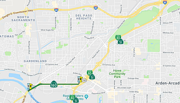
The North Sacramento Freeway has an interesting quirk: Unlike all other freeways in California, there are no shields on the green sign gantries, only control cities (Downtown Sacramento and Roseville/Reno). According to Joel Windmiller, the signs were placed in the mid-1960s, in the midst of the Great Renumbering when US 40 was removed from this route; however, CalTrans was not sure what route would eventually assimiliate the North Sacramento Freeway at the time (now Route 160).
Pre 1964 Signage HistoryThe portion from Broadway west from Freeport to 16th: was LRN 4, and was signed as Route 24, US 50/US 99 (to 1954), and US 99W (1954-1964). The portion from 16th Street in Sacramento north from Broadway to N Street, Capitol Avenue was LRN 4 and was signed as US 50/US 99 (to 1954), and US 99W (1954-1964). The remainder of the route was LRN 3 (defined in 1909), and was signed as follows: the segment from 15th/16th Street north of Capitol Avenue to the 16th Street Bridge was signed as US 40 (to 1964) and US 99E (to 1954); the segment from 12th Street and F Street to 15th Street was signed as US 40 (1950s-1964); and the segment from the 16th Street Bridge and North Sacramento Freeway was signed as US 40 (to 1964) and US 99E (1946-1954).
StatusRoute 160 is constructed to freeway standards from Downtown Sacramento to Business Route 80 (Route 51) near Cal Expo.There are "END 160" signs at each crossing of the Sacramento City Limits.
In April 1999, the city of Sacramento begin a study whether it should take over control of Route 160 from the state. The city wanted better access, and CalTrans was unwilling to add additional off ramps. This was expected to lead to the replacement of the bridges at Royal Oaks Dr. and Canterbury Rd with ground-level intersections. In February 2001, the city of Sacramento and Caltrans reached an agreement to relinquish a portion of Route 160 to the city. In particular, the portion from Stonecrest Ave. to the south abutment of the American River Bridge, where the freeway splits into 12th and 16th Sts, was to be relinquished. Stonecrest Ave. is the southern edge city of Sacramento (it's the road running parallel to the PG&E transmission line that passes over I-5 just south of Pocket Rd. next to the GTE/Verizon complex). Note that this excludes the American River Bridge; this be because the city believed the bridge to be falling apart. There are actually two bridges; the southbound bridge was built in 1921 and the northbound bridge in 1967.
In October 2015, the CTC approved the following SHOPP action: 3-Sac-160 T1.8/4.2 Route 160 In and near the city of Sacramento, from Route 50 to Watt Avenue. Relinquish route to local agencies. PAED: 01/20/2016 R/W: 01/20/2016 RTL: 01/20/2016 CCA: 03/15/2016 Costs: $450K (C) Completion: FY15/16. $59K Support.
At 16th and P Street, a very old BGS is present, pointing the way to San Francisco and Reno. This may date back to the days when this portion of Route 160 was the junction of Route 24 and US 40. The greenout on those signs that covers up the number 40; it's right next to the arrows. At one point, Route 160 and US 40 were cosigned.
According to the Sacramento Bee, plans are in the works to rebuild the intersection of Route 160, Sproule Avenue, Richards Blvd, 12th Street and 16th Street near downtown Sacramento. The problem is that one can't get from Richards Boulevard eastbound onto northbound Route 160, nor from northbound 16th Street to Richards Boulevard. The city of Sacramento is planning to construct a $4.8 million intersection there that will integrate a light-rail line through the intersection. The project should be complete in 2008.
NamingThe portion of this route that is former US 99 is, in local usage, called the "East Side Highway".
The portion of this route from roughly Del Paso Blvd and Route 51 (Business Route 80) (i.e., former US 40) was named the "North Sacramento Freeway". Sacramento refers to the City of Sacramento CA, which is based off of the name of the main river in the city. The Spanish name, "Holy Sacrament," was applied to the Feather River in 1808; it was later assumed that the lower Sacramento was the same stream. In 1817 the two main rivers of the valley were recorded as Sacramento and San Joaquin rivers, but the course of the former was not identified with the name until the 1830s. The city was laid out in 1848-1849 and named after the river by John A. Sutter, Jr., and Sam Brannan. The county, one of the original 27, was named in 1850.
 Historical Route
A small portion of this route is designated as part of "Historic US Highway 99" by Assembly Concurrent Resolution 19, Chapter 73, in 1993.
 Exit Information
 National Trails
 This route was selected by the Victory Highway Association as part of its route from Sacramento to
San Francisco by the 1926 opening of the Antioch-Sherman Bridge, in spite
of the twelve miles of poor road S of Rio Vista and the two ferries
existing at Three-Mile Slough and at Antioch-Sherman.
This route was selected by the Victory Highway Association as part of its route from Sacramento to
San Francisco by the 1926 opening of the Antioch-Sherman Bridge, in spite
of the twelve miles of poor road S of Rio Vista and the two ferries
existing at Three-Mile Slough and at Antioch-Sherman.
(Source: Email from Joel Windmiller, 2/4/2023; Image source: PBA Galleries)
 Other WWW Links
 Scenic Route
[SHC 263.7] From Route 4 near Antioch to Sacramento.
 Classified Landcaped Freeway
The following segments are designated as Classified Landscaped Freeway:
| County | Route | Starting PM | Ending PM |
| Sacramento | 160 | 44.94 | 45.30 |
| Sacramento | 160 | 46.06 | 46.34 |
 Freeway
[SHC 253.7] From Route 4 near Antioch to Route 12 near Rio Vista; and from Sacramento to Route 51 (Business Route 80). Added to the Freeway and Expressway system in 1959.
 Blue Star Memorial Highway
The portion of this route that is former US 40 was designated as a "Blue Star Memorial Highway" by Senate Concurrent Resolution 33, Ch. 82 in 1947.
 Interregional Route
[SHC 164.18] Between the north urban limits of Antioch-Pittsburg and the south urban limits of Sacramento.
 Statistics
Overall statistics for Route 160:
 Pre-1964 Legislative Route
In 1933, Chapter 767 defined the route "Highland Avenue, Los Angeles from Cahuenga Blvd to Santa Monica Blvd" as a state highway. In 1935, this was added to the highway code as LRN 160 with this routing.
In 1949, Chapters 909 and 1467 clarified the routing to be: "Highland
Avenue, Los Angeles from Cahuenga Blvd [LRN 2] to
Santa Monica Blvd [LRN 162]"
In 1953, Chapter 1253 simplified the definition to eliminate the specific
routing: "Highland Avenue, Los Angeles from [LRN 2] to [LRN 162]in the Hollywood Area, Los Angeles"
In 1959, Chapter 1062 clarified and extended the routing: "[LRN 158]
near Inglewood to [LRN 2] in Los Angeles to [LRN 162] in the Hollywood Area, Los Angeles"
This route ran from the future I-405 near Inglewood to US 101 in Los Angeles. This was a freeway that was never constructed; the "Laurel Canyon" freeway, Route 170, between the San Fernando Valley and Inglewood. It is the reason that the offramp from I-405 NB at La Cienega is constructed as it is; it is also the reason for the "La Cienega Expressway" between Centinela (former Route 107) and Rodeo. There are portions that still indicate the Route 170 presence. The only designated portion was along Highland between LRN 2 and Santa Monica Blvd.
© 1996-2020 Daniel P. Faigin.
Maintained by: Daniel P. Faigin
<webmaster@cahighways.org>.
 Route 159
 Route 161