
 California Highways:
Click here for a key to the symbols used. An explanation of acronyms may be found at the bottom of the page.
 Routing
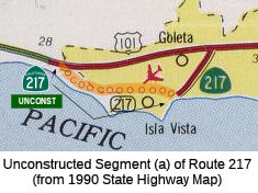 From Route 101 near Ellwood to the campus of the University of California at
Santa Barbara (UCSB).
From Route 101 near Ellwood to the campus of the University of California at
Santa Barbara (UCSB).
 Post 1964 Signage History
This segment was not part of the 1963 definition of Route 217. It was added in 1965 by Chapter 1372 as “(a) Route 101 near Ellwood to the Goleta Campus of the University of California.”
In 1968, Chapter 282 changed "Goleta Campus of the University of California" to "campus of the University of California at Santa Barbara".
 Pre 1964 Signage History
This segment was not defined before 1963. The route was not signed before 1964.
 Status
The route is unconstructed from UCSB campus to Route 101. There are not any local roads that adequately fit the description of a traversable highway. Caltrans recommends unadopting the route, as it traverses a highly sensitive environmental area, an industrial park, and several residential subdivisions. There are no plans to construct this route by the city or the state. Note that it is not El Colegio Road and Storke Road
The 2013 Traversable Highways report notes that no local roads adequately fit the description of a traversable highway. No plans to construct this route by the County or State. This route should be unadopted, it traverses a highly sensitive environmental area, an industrial park and several residential subdivisions.
 From the campus of the University of California at Santa Barbara (UCSB) to
Route 101 northwest of the City of Santa Barbara.
From the campus of the University of California at Santa Barbara (UCSB) to
Route 101 northwest of the City of Santa Barbara.
Note: The state has authorized relinquishment of the portion of Route 217 from the westerly end of both the East Goleta Overhead and the Route 101/Route 217 separation structures to UCSB. Authorized by SB 532, Ch 1007, 10/10/99. This segment has not yet been relinquished, according to the CalTrans Photologs made available in 2001.
Post 1964 Signage HistoryIn 1963, this segment was the entire route, and was defined as:
“the Goleta Campus of the University of California at Santa Barbara to Route 101 northwest of the City of Santa Barbara.
The commission shall allocate from the State Highway Fund the necessary funds for the construction of said route. The allocation of money provided for in this section shall be made out of moneys contained in the State Highway Fund available for construction of state highways in County Group No. 2, but which is not subject to Section 188.4; and expenditures from such allocation shall be credited against the expenditures required to be made pursuant to Section 188.4 in Santa Barbara County until June 30, 1963. This route shall be a memorial to the late Senator Clarence C. Ward of Santa Barbara County and shall hereafter be known as Clarence Ward Memorial Boulevard.”
In 1965, Chapter 1371 deleted the text on funding, but the text was restored by Chapter 1372 that same year, which changed the funding text to refer to "Section (b) of this route" and added section (a).
In 1968, Chapter 282 changed "Goleta Campus of the University of California" to "campus of the University of California at Santa Barbara"... and removed the funding text again.
Pre 1964 Signage HistoryThis segment was LRN 236, defined in 1955. The route was not signed before 1964.
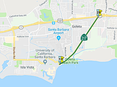
StatusSan Jose Creek Bridge No. 51-0217 Replacement (05-SB-217 0.9/1.4)
") The following project was included in the final adopted 2018 SHOPP in March 2018: PPNO 2386. 05-Santa Barbara-217 0.8/1.4. Route 217 Near Goleta, from 0.2 mile south to 0.4 mile north of San Jose
Creek Bridge No. 51-0217. Replace bridge. Begin Con: 4/1/2022. Total
Project Cost: $30,810K.
The following project was included in the final adopted 2018 SHOPP in March 2018: PPNO 2386. 05-Santa Barbara-217 0.8/1.4. Route 217 Near Goleta, from 0.2 mile south to 0.4 mile north of San Jose
Creek Bridge No. 51-0217. Replace bridge. Begin Con: 4/1/2022. Total
Project Cost: $30,810K.
In June 2019, the CTC approved the following SHOPP
scope amendment: 05-SB-217 0.8/1.4 0.9/1.4 PPNO
2386. Near Goleta, from 0.1 0.2 mile south to 0.4
mile north of San Jose Creek Bridge No. 51-0217. Replace bridge. Increase
in construction capital is due to bridge design change from seven spans to
two spans. This is necessary to reduce the impacts of columns within the
creek. The new bridge requires a deeper structure depth, raising the
roadway profile and requiring additional earthwork, landscaping, and
working days. Increase in R/W capital is due to the larger footprint of
the earthwork slopes requiring acquisitions and increase in mitigation
costs. Updated cost: $42,318K
(Source: June 2019 CTC Minutes, Agenda Item
2.1a.(1) Scope Item 71)
The 2020 SHOPP, approved in May 2020, included the
following Bridge Restoration item of interest (carried over from the 2018
SHOPP): 05-Santa Barbara-217 PM 0.9/1.4 PPNO 2386 Proj ID 0512000134 EA
1C360. Route 217 near Goleta, from 0.1 mile south to 0.4 mile north of San
Jose Creek Bridge No. 51-0217. Replace bridge. Programmed in FY21-22, with
construction scheduled to start in April 2022. Note: Construction
capital and construction support phases are not authorized. Total
project cost is $42,318K, with $28,034K being capital (const and right of
way) and $14,284K being support (engineering, environmental, etc.).
(Source: 2020 Approved SHOPP a/o May 2020)
In October 2020, the CTC approved for future
consideration of funding the following project for which a Mitigated
Negative Declaration (MND) has been completed: Route 217 in Santa Barbara
County. Replace the existing San Jose Creek Bridge on Route 217 in
Santa Barbara County. (05-SB-217, PM 0.9/1.4) (PPNO 2386). This project is
located in Santa Barbara County, near Goleta on Route 217. The Department
proposes to replace the San Jose Creek Bridge. This project is currently
programmed in the 2020 SHOPP for a total of $42,318,000 and $34,217,000 is
currently through G-13 Contingency. Construction is estimated to begin
2021-2022. The scope, as described for the preferred alternative, is
consistent with the project scope programmed by the Commission in the 2020
SHOPP.
(Source: October 2020 CTC Agenda, Agenda Item
2.2c.(1))
In October 2020, the CTC approved the following SHOPP
SB1 Support Phase allocation: $3,459,000 for PS&E for 05-SB-217 PM
0.9/1.4. PPNO 05-2386 ProjID 0512000134 EA 1C360. Route 217 Near Goleta,
from 0.1 mile south to 0.4 mile north of San Jose Creek Bridge No.
51-0217. Replace bridge. (Concurrent consideration of funding under
Resolution E-20-102; October 2020.)
(Source: October 2020 CTC Agenda, Agenda Item
2.5b.(2b) #6)
In January 2021, the CTC amended the SHOPP for this
project: (1b) #11. 05-SB-217 0.9/1.4 PPNO 2386 ProjID 0512000134 EA 1C360.
Route 217 Near Goleta, from 0.1 mile south to 0.4 mile north of San Jose
Creek Bridge No. 51-0217. Replace bridge. Amended to increase R/W
capital due to a need for offsite mitigation to meet permit requirements
and an increase in the number of utilities needing relocation. R/W
Cap went from $599K to $833K, for a revised total of $42,552K.
(Source: January 2021 CTC Agenda, Agenda Item
2.1a.(1b) #11)
In June 2021, the CTC approved the following amendment
to the 2020 SHOPP: 05-SB-217 0.9/1.4 PPNO 2386 ProjID 0512000134 EA
05-1C360. Near Goleta, from 0.1 mile south to 0.4 mile north of San Jose
Creek Bridge No. 51-0217. Replace bridge. Note: Increase construction
capital to fund a required future landscape mitigation monitoring child
project. Const Cap $27,435K $28,807K; Total
$42,552K $43,924K.
(Source: June 2021 CTC Agenda, Agenda Item
2.1a.(1d) #33)
In February 2022, the California Coastal Commission
reviewed an application to to replace the Route 217 bridge at San Jose
Creek (05-SB-217 0.9/1.4) with new bridge with four traffic lanes,
standard bridge railings and shoulders, separated bicycle and pedestrian
path, and coastal hazards adaptation features, located between the City of
Goleta and the University of California, Santa Barbara in unincorporated
Santa Barbara County. The application described the project as "Route 217
at the crossing of San Jose Creek, from postmile 0.9 to postmile 1.4,
Santa Barbara County. Project Description: Deconstruct and replace the
highway bridge with a new bridge with four traffic lanes, standard bridge
railings and shoulders, a widened Class I bicycle and pedestrian path, and
design features that allow for additional elevation to accommodate future
coastal hazards; and habitat restoration and monitoring." The CDP
application also notes: Caltrans proposes to construct a new pre-cast,
wide flange girder bridge approximately 213.6 feet long and 105 feet wide
with a 4.75-foot-thick deck. The upstream soffit elevation will be 13.5
feet, and the downstream soffit elevation will be 16.4 feet NAVD88. 4
Replacement will occur in two stages. The new east abutment will be in the
same location as the existing east abutment, while the new west abutment
will be located approximately 10 feet west of the existing west abutment.
The new abutments will be outside the edges of the stream banks and above
the Ordinary Highway Water Mark (OHWM). The thicker, longer bridge deck
will allow Caltrans to reduce the number of bridge spans from seven to
two. Accordingly, the number of bridge piers will be reduced from six to
one, with the proposed bridge including a single pier of 8,
66-inch-diameter piles. The proposed project also includes restoration to
compensate for habitat impacts associated with the bridge replacement. The
proposed bridge will maintain the existing four-lane configuration and
will meet modern safety standards for shoulder widths. The width of the
inside shoulder will increase from 8 feet to 10 feet, and the width of the
outside shoulder will increase from 4.7 feet to 10 feet. These widened
shoulders will allow vehicles to pull completely out of the travel lane in
case of an emergency. Like the existing bridge, the proposed bridge will
include a separated, Class I bicycle and pedestrian path along the
northbound outside shoulder. The proposed bridge will widen this path from
8 feet to 10 feet to enhance bicycle and pedestrian safety and access, and
will include an open-style railing to maximize views of San Jose Creek.
The proposed bridge will include construction of new roadway stormwater
drainage facilities, such as new dikes and over-side drains, to
accommodate future stormwater flows. Six new roadway lights will be added
as part of the project, two northeast of the bridge and four southwest of
the bridge in the Sandspit Road interchange. Caltrans will also remove the
existing flashing beacon system on the southbound highway immediately
before the bridge, for a net total of five new lights. None of the
new lights are located on the bridge deck or above San Jose Creek. The
proposed bridge structure will include features to allow Caltrans to raise
the structure in the future to accommodate coastal hazards, which may be
exacerbated by sea level rise within the bridge’s expected 75-year
service life. Additional rebar with couplers and pins will be installed to
allow for extension of the bridge piles, whereby the deck could be jacked
to an increased height. A project to raise the bridge structure in this
way and re-design the road approaches at either end would be programmed
and
planned by Caltrans based on monitoring of future sea level rise and
associated impacts at the project site, and is not included as part of the
proposed project. Construction is projected to start in 2023 and will
require about 550 workdays over a duration of approximately 30 calendar
months. The staged construction will most likely require two calendar
years to perform the various activities within the waterway during
the in-stream work season (June 1 to October 31).
(Source: California Coastal Commission Minutes,
February 2022, Application No. 4-21-0182)
In October 2022, the CTC approved the following
construction phase allocation: $34,507,000. 05-SB-217 0.9/1.4. PPNO
05-2386; ProjID 0512000134; EA 1C360. Route 217 Near Goleta, from 0.1 mile
south to 0.4 mile north of San Jose Creek Bridge № 51-0217. Outcome/Output:
Replace bridge with new structure which meets current standards and
provides shoulders for disabled vehicles, maintenance workers, pedestrians
and bicycles. Programmed allocation: CON ENG $6,782,000; CONST
$27,157,000. CEQA - MND, 9/20/2020; Re-validation 8/18/2022. NEPA - CE,
10/8/2020; Re-validation 8/18/2022. Future consideration of funding
approved under Resolution E-20-102; October 2020. Seven month time
extension for CONST and CON ENG approved under Waiver 22-73; June 2022.
SB1 Baseline Agreement approved under Resolution SHOPP-P-2021-04B: January
2021.
(Source: October 2022 CTC Agenda, Agenda Item
2.5b.(1) #11)
Fowler Road Extension (SB 1.1 to SB 2.2)
In February 2012, the CTC approved for future consideration of funding a project that will extend Fowler Road from South Street to Fairview Avenue; extend Ekwill Street from Kellogg Avenue to Fairview Avenue; and add roundabouts at the Fowler Road/Fairview Avenue intersection, at the Ekwill Street/Pine Avenue intersection, and at the Route 217 northbound and southbound on- and off-ramps. This project will also add a right turn lane and modify parking on Kellogg Avenue near Hollister Avenue. The project is programmed in the 2010 State Transportation Improvement Program (STIP). The total estimated project cost is $17,955,000 for capital and support. Construction is estimated to begin in Fiscal Year 2012-13. The scope, as described for the preferred alternative, is consistent with the project scope programmed by the Commission in the 2010 STIP. A copy of the FEIR has been provided to Commission staff. Resources that may be impacted by the project include; noise, biological resources including wetlands and Waters of the U.S. Potential impacts associated with the project can all be mitigated to below significance through proposed mitigation measures.
The 2018 STIP, approved at the CTC March 2018 meeting, appears to allocate funding for PPNO 4611, SB 1.1/2.2, In Goleta, from 0.1 mile north of San Jose Creek Bridge to Hollister Avenue. Construct roundabouts at Hollister Avenue ramps. Extend Fowler Road from Fairview Avenue to Kellogg Avenue. Extend Ekwill Street to Kellogg Avenue. The STIP shows funding being adjusted from $9.272M to $11.372M, and the construction being delayed to FY20-21.
The 2020 STIP, approved at the March 2020 CTC meeting,
continued the financial programming for PPNO 4611 "Rt 217, Fowler and
Ekwill St extensions"
(Source: March 2020 CTC Agenda, Item 4.7, 2020 STIP
Adopted 3/25/2020)
In January 2023, the CTC approved the following STIP
allocation: $11,372,000. 05-SB-217 1.1/2.2 2.1/2.5.
PPNO 05-4611; ProjID 0500000548; EA 4611U. Fowler Road & Ekwill
Street Extension. Route 217 In Goleta, from 0.1 mile north of
San Jose Creek Bridge to Hollister Avenue. Construct roundabouts at
Hollister Avenue ramps. Extend Fowler Road from Fairview Avenue to
Kellogg Avenue. Extend Ekwill Street to Kellogg Avenue. In Goleta,
from 1.1 mile north of San Jose Creek Bridge to Hollister Avenue.
Construct roundabouts at Hollister Avenue ramps. Extend Fowler Road from
Kellogg Avenue to Technology Drive. Extend Ekwill Street from Kellogg
Avenue to Fairview Avenue. CEQA - EIR, 11/16/2011; Re-validation
06/07/2022. NEPA - CE, 11/16/2011; Re-validation 06/07/2022. Right of Way
Certification: 11/14/2022. Contribution from other local sources:
$3,198,000. Future consideration of funding approved under Resolution
E-12-07; February 2012. Time Extension for FY 20-21 CON expires on
02/28/2023. Commission staff recommended approval of a minor scope change
on 12/27/2022. CONST $11,372,000.
(Source: January 2023 CTC Agenda, Agenda Item 2.5c.(2))
 Naming
 This section named the "Clarence Ward Memorial Boulevard". It was named by Assembly Bill 2718,
Chapter 1953, in 1955. California State Senator Clarence C. Ward served
the people of Santa Barbara County from 1941 to 1955. He was a former
Santa Barbara District Attorney, and was one of the sponsors of the
enabling law that created the Santa Barbara College of the University of
California in Santa Barbara on July 1, 1944 (taking over the facilities of
Santa Barbara State College).
This section named the "Clarence Ward Memorial Boulevard". It was named by Assembly Bill 2718,
Chapter 1953, in 1955. California State Senator Clarence C. Ward served
the people of Santa Barbara County from 1941 to 1955. He was a former
Santa Barbara District Attorney, and was one of the sponsors of the
enabling law that created the Santa Barbara College of the University of
California in Santa Barbara on July 1, 1944 (taking over the facilities of
Santa Barbara State College).
(Image source: AARoads)
 Classified Landcaped Freeway
The following segments are designated as Classified Landscaped Freeway:
| County | Route | Starting PM | Ending PM |
| Santa Barbara | 217 | 1.05 | 2.87 |
 Exit Information
 Other WWW Links Status
 Part (1) unconstructed. Part (2) is constructed to freeway standards from Goleta to Route 101.
 Freeway
[SHC 253.1] Entire route. Added to the Freeway and Expressway system in 1965.
 Statistics
Overall statistics for Route 217:
 Pre-1964 Legislative Route
This route number appears not to have been assigned by the California Legislature before the 1963 renumbering.
© 1996-2020 Daniel P. Faigin.
Maintained by: Daniel P. Faigin
<webmaster@cahighways.org>.
 Route 216
 Route 218