
 California Highways:
Click here for a key to the symbols used. An explanation of acronyms may be found at the bottom of the page.
 Routing
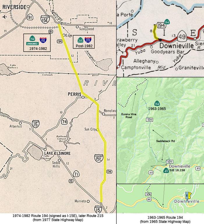 Nocurrent
routing.
Nocurrent
routing.
 Suffixed Routings
The 1974-1982 routing was once signed as I-15E.
 Post 1964 Signage History
 As defined on July 1, 1964, Route 194 ran from Route 49 near
Downieville to Eureka Mine Road near Saddleback Mountain.
The route ran along Saddleback Road. It appears not to have been signed, and was one of the last dirt unimproved single-lane state highways.
In 1965, Chapter 1372 deleted this routing.
In 1974, Chapter 537 redefined the route: "Route 15 near Temecula
to Route 15 near Devore via San Bernardino and passing near Riverside."
This routing was signed as I-15E (Route 194 was created because
legislatively one could not have suffixed routes). The 1974 renumbering
was concurrant with the creation of a new definition for Route 15 to the
west.
In 1982, Chapter 681 deleted this routing and renumbered it was "Route 215".
Some significant history of this route (as I-15E) is discussed under I-15.
 Pre 1964 Signage History
 The 1964-1965 routing with the number (near Downieville) was LRN 36.
The route that became LRN 36 goes back to the original definition of the
Sierra State Highway in 1907: "An act to make an appropriation for the
location, survey, and construction of a state highway from a point known
as the Mt. Pleasant Ranch on the road between Quincy and Marysville thence
in a SE-ly direction by a place called Eureka to Downieville, Sierra
Cty.". This became Route 36 internally, and was codified in the mid-1930s
with the definition of the legislative route numbers. Surveys for the path
of LRN 36 took place in 1915. In particular, the California Highway
Commission ordered surveys to connect Downieville to other counties and
centers of population on September 22, 1914. By 1918, LRN 36 was
shown on state maps as a special appropriations road with the simplified
definition of "Downieville to Mount Pleasant." By 1920, LRN 36 was
state maintained and aligned between Downieville to the vicinity of the
Eureka Mine via the Eureka Mine Road. It was an unimproved local
road taken over by the State between Downieville and Mount Pleasant in
1907. The 1935 Division of Highways Map of Sierra County included
LRN 36 as beginning at Route 49/LRN 25 at Cannon Point and following the
Eureka Mine Road to Saddleback Mountain. The Eureka Mine Road is
displayed on modern maps as Saddleback Road. This route was not a
pre-1964 signed route.
(Source: Gribblenation Blog (Tom Fearer), "Former California State Route 194 from Downieville to Saddleback Mountain", July 2022)
Scott Parker on AARoads provides some interesting history on this
segment:
(Source: Scott Parker (SParker) on AARoads, "Re: Former CA 194 north from CA 49 to Saddleback Mountain", 7/8/2019)
It seems that both LRN 30 and LRN 36 were exercises in "how to get to Quincy the hard way!" Since the corridor the Division of Highways really wanted, LRN 21 through the Feather River Canyon, was a long hard slog in terms of construction; the 1907-09-built Western Pacific main line occupied most of the readily available alignment in the canyon, and the state highway had to carve out a path for itself wherever the railroad wasn't. So in the interim, any traffic from the Sacramento Valley to Quincy (then a significant lumber and mining center) had to go "over the hill" on LRN 30, which by all accounts was a treacherous oiled-earth road that crossed some severe topology -- but was still CSAA-signed as Route 24, a designation that was switched to LRN 21 as soon as that facility was completed. My guess is that LRN 36 was intended to be a logical extension of the "Gold Center" corridor that characterized Route 49 (and its various LRN iterations), since if it served Quincy, a major mining center, the route would have maintained its original purpose rather than surmount Yuba Pass and end up on the eastern Sierra slope. I'd go so far as to say that if LRN 36 had been completed to Quincy, Route 49 would have been rerouted over it and the remainder of LRN 25 east to LRN 83/Route 89 at Sattley would have seen a different SSR designation. But similar topological obstacles to the ones encountered on LRN 30 existed for a potential LRN 36 extension as well, so once the Feather River Canyon route was opened to traffic, and further plans for LRN 36 were dropped along with the decommissioning of LRN 30. Whoever owned/operated the now-defunct mine north of Downieville probably had enough political clout to ensure that the stub route was state maintained, so it remained on the books until '65.
 The post-1974 routing was as follows:
Route 194 was not defined as part of the initial state signage of routes in 1934. It is unclear what (if any) route was signed as Route 194 between 1934 and 1964.
 Interstate Submissions
The portion from Devore to I-10 was accepted as 139(b) non-chargeable mileage in 1972 as I-215, changed to I-15E in 1973, changed back to I-215 in 1982 when the route was renumbered as Route 215. The portion between Route 10 and Route 60 was accepted as 139(a) mileage in 1973. The portion between Route 60 and Route 15 was accepted as 139(a) mileage in 1972.
 Other WWW Links
 Pre-1964 Legislative Route
In 1933, Chapter 767 defined the routes from "The Descanso-Temecula Road near Aguanga to Hemet" and "Hemet to [LRN 19] near Moreno" as part of the state highway system. In 1935, these were added to the highway code as LRN 194, with the routing:
In 1959, Chapter 1062 changed the ends and relaxed the routing: "[LRN 19] near Moreno [LRN 78] east of Temecula to [LRN 78] near Aguanga [LRN 26] near Beaumont via the
vicinity of Hemet". This is the routing of Route 79 along Lamb
Canyon. The portion from [LRN 78] to Moreno (Gilman Springs Road) became
LRN 186 in 1959 (Route 177) and was later deleted.
© 1996-2020 Daniel P. Faigin.
Maintained by: Daniel P. Faigin
<webmaster@cahighways.org>.
 Route 193
 Route 195