
 California Highways:
Click here for a key to the symbols used. An explanation of acronyms may be found at the bottom of the page.
 Routing
 Post 1964 Signage History
The definition of this route is unchanged from 1963.
In late 1964, two freeway segments of Route 125 were adopted by the
California Highway Commission. The first segment began at I-8 in La Mesa
and extended north to Mission Gorge Road to a planned junction with Route 52. The second extended north from the Otay River. The new alignment of
Route 125 multiplexed the Route 94 freeway from the vicinity of Sweetwater
Road to Campo Road.
(Source: Gribblenation Blog (Tom Fearer), "California State Route 94", 12/10/2023)
The Route 94 freeway between Kenwood Road/Conrad Drive east to Avocado
Boulevard opened in July 1970. The northern interchange between Route 94
and Route 125 was rebuilt to freeway standards and openied to traffic in
January 1976.
(Source: Gribblenation Blog (Tom Fearer), "California State Route 94", 12/10/2023)
According to Andy Field, the western end of this route was originally to connect to Route 163. It is unclear if this would have been an all Route 94 loop in downtown San Diego, or part Route 163 and part Route 94.
 Pre 1964 Signage History
Originally, Route 94 was part of a stage road between San Diego and Yuma.
During 1869, a new stage road was surveyed through Campo at the behest of
San Diego County by James Pascoe. The Campo Road can be seen on the 1882
Bancroft's Map of California extending from San Diego east to towards the
Mountain Springs Grade by way of Campo. The Campo Road largely strayed
south of the Texas & Pacific Railway east of San Diego towards
Imperial Valley. During 1915 the Campo Road became part of the Auto Trail
known as the Old Spanish Trail. The Old Spanish Trail originated at Horton
Square in San Diego at Broadway and 4th Avenue. The Old Spanish
Trail crossed the southern United States and terminated in Florida in St.
Augustine. In 1931, the county of San Diego submitted Campo Road to the
California Highway Commission for consideration as a secondary State
Highway.
(Source: Gribblenation Blog (Tom Fearer), "California State Route 94", 12/10/2023)
In 1934, Sign Route 94 was signed along the route from San Diego to Jct. US 80 (I-8) at White Star, via Jamul and Campo. This originally ran along Campo Road, Federal Blvd, and Market Street (although it may have also run along Broadway) to Pacific Highway. It was LRN 200, defined in 1933, as "[LRN 2] near San Diego to [LRN 12] W of Jacumba via Campo". In 1935, this was added to the state highway code with the same routing.
LRN 200 originated at US 101/LRN 2 and US 80/US 395/LRN 12 in downtown
San Diego at Broadway/12th Avenue. LRN 200 departed downtown
San Diego via Broadway, 30th Street, F Street and Lemon Grove
Boulevard (now Federal Boulevard). East of San Diego, LRN 200 passed
through Jamul, Potrero and Campo. By 1938, Sign Route 94/LRN 200 was
extended west of 12th Avenue via Broadway to the new alignment
of US 101/LRN 2 at Pacific Highway. US 80/US 395 along LRN 12 was extended
south of Broadway via 12th Avenue to US 101/LRN 2. By 1944, an
expansion of Harbor Drive realigned US 101/LRN 2 onto a bypass of Market
Street in downtown San Diego. The new alignment of US 101 along Harbor
Drive saw US 80/US Route 395/LRN 12 extended west of 12th
Avenue via Market Street. Sign Route 94/LRN 200 was then realigned to a
new origin point at Market Street/12th Avenue. Sign Route 94/LRN 200 then departed downtown San Diego via Market Street, 32nd
Street and Federal Boulevard towards Lemon Grove. In 1947, LRN 77 was
realigned onto 11th Avenue in downtown San Diego as part of the
Cabrillo Freeway corridor. The new alignment of US 395/US 80/LRN 77 in
downtown San Diego on 11th Avenue extended Sign Route 94/LRN 200 a block west from 12th Avenue.
(Source: Gribblenation Blog (Tom Fearer), "California State Route 94", 12/10/2023)
By the mid 1950s, there were plans to realign Sign Route 94 near Barrett
Junction, and to widen it to freeway standards between Euclid and Campo
Road. It was at this time the route gained the name of the "Wabash
Freeway". The Wabash Freeway also included a portion of Sign Route 67/LRN 198 to US 80/LRN 12. The Wabash Freeway alignment from Wabash
Boulevard-Campo Road was adopted by the California Highway Commission on
June 17, 1953. This was followed by the adoption of the Campo Road-US 80
segment on October 22, 1953, and the 18th Street-Wabash
Boulevard segment on November 17, 1954. The Wabash Freeway began at the
planned junction with the US 101 freeway in downtown San Diego at F Street
and 18th Street. The Wabash Freeway between Wabash Boulevard
and 56th Street opened on March 18, 1957. This construction saw
Sign Route 94/LRN 200 realigned onto the Wabash Freeway east to Campo
Road. The segment of the Wabash Freeway from Campo Road east to US 80/LRN 12 was now the new alignment of Sign Route 67/LRN 198. Construction of the
Wabash Freeway west of Wabash Boulevard to 18th Street was
planned for the 1957-58 Fiscal Year. Note that by 1960, the Wabash Freeway
name was no longer being used.
(Source: Gribblenation Blog (Tom Fearer), "California State Route 94", 12/10/2023)
 Status
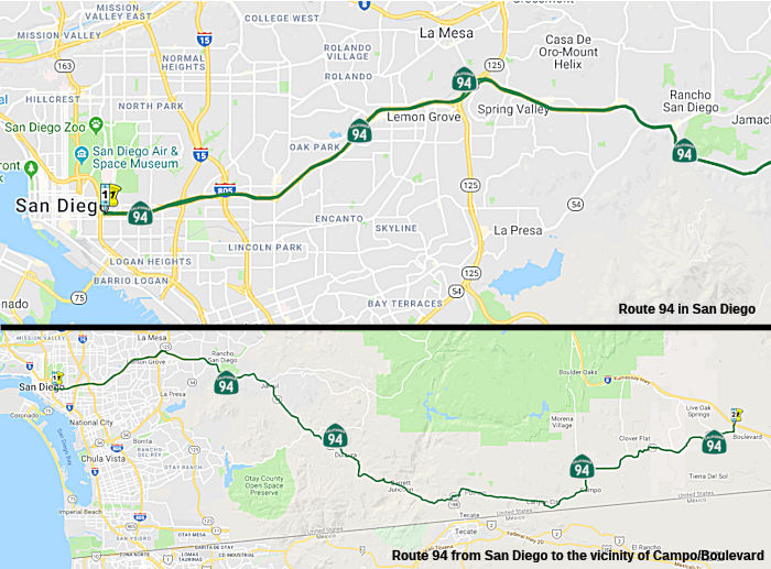
Route 5 in San Diego to Route 125 near Spring Valley
Route 94 HOV / Express Lanes (~ SD 1.501 to SD 4.03)
![[Map]](maps/094-tcrp-77.jpg) In September 2007, the CTC approved a
resolution to revise the project scope and update the schedule and funding
plan for TCRP Project #77 – Route 94; complete environmental studies
and construct HOV lanes from downtown San Diego (Route 5) to Route 805 in
San Diego County (~ SD 1.501 to SD 4.03). In 2002, San Diego Association
of Governments (SANDAG) developed an additional tax ordinance for
transportation in the region, TransNet II. At the same time, SANDAG took
the opportunity to study in detail both HOV lane needs and the development
of Bus Rapid Transit (BRT) routes throughout the region. As the studies
impacted the Route 94 alternative study, the decision was made to postpone
further work on this project until final decisions were made by SANDAG. In
November 2005, San Diego voters passed TransNet II. With the TransNet II
funds now available, SANDAG, in conjunction with the Department, resumed
the alternative study identifying several projects along the Route 94
corridor. As part of recent Regional Transportation Plan (RTP) updates,
SANDAG has completed its HOV and BRT studies. These studies show a high
priority need for critical HOV and BRT efforts on Route 94 between Route 5
and Route 805, while the Route 94 segment between Route 805 and Route 125
(the portion of original TCRP #77 limits) was shown as a lower priority
need for HOV and BRT. To address the high priority need, Caltrans
requested to reduce the limits of the project to the area between Route 5
and Route 805 only. The scope of the work would expand to include
construction of HOV lanes and the implementation of BRT service from Route 15 to Route 805. It is anticipated that funding for the construction of
the HOV lanes will come from a combination of local, State and federal
sources. The schedule and funding for the segment between Route 805 and
Route 125 will be addressed in the future under a completely separate
project. It is anticipated that construction will be complete in
FY2015/2016.
In September 2007, the CTC approved a
resolution to revise the project scope and update the schedule and funding
plan for TCRP Project #77 – Route 94; complete environmental studies
and construct HOV lanes from downtown San Diego (Route 5) to Route 805 in
San Diego County (~ SD 1.501 to SD 4.03). In 2002, San Diego Association
of Governments (SANDAG) developed an additional tax ordinance for
transportation in the region, TransNet II. At the same time, SANDAG took
the opportunity to study in detail both HOV lane needs and the development
of Bus Rapid Transit (BRT) routes throughout the region. As the studies
impacted the Route 94 alternative study, the decision was made to postpone
further work on this project until final decisions were made by SANDAG. In
November 2005, San Diego voters passed TransNet II. With the TransNet II
funds now available, SANDAG, in conjunction with the Department, resumed
the alternative study identifying several projects along the Route 94
corridor. As part of recent Regional Transportation Plan (RTP) updates,
SANDAG has completed its HOV and BRT studies. These studies show a high
priority need for critical HOV and BRT efforts on Route 94 between Route 5
and Route 805, while the Route 94 segment between Route 805 and Route 125
(the portion of original TCRP #77 limits) was shown as a lower priority
need for HOV and BRT. To address the high priority need, Caltrans
requested to reduce the limits of the project to the area between Route 5
and Route 805 only. The scope of the work would expand to include
construction of HOV lanes and the implementation of BRT service from Route 15 to Route 805. It is anticipated that funding for the construction of
the HOV lanes will come from a combination of local, State and federal
sources. The schedule and funding for the segment between Route 805 and
Route 125 will be addressed in the future under a completely separate
project. It is anticipated that construction will be complete in
FY2015/2016.
 In 2015, it was reported that Caltrans has been studying
the environmental impacts of adding Express Lanes along Route 94 between
I-805 and Downtown San Diego. The addition of these Express Lanes would
support the planned South Bay Rapid service, as well as carpools and
vanpools along the route. Local and state representatives, as well as
community stakeholders, along the project alignment have requested that
Caltrans and SANDAG consider incorporating community-based alternatives
into the SR 94 Express Lanes Draft Environmental Impact Report (EIR).
Specifically, there was a request to study buses on shoulders options,
general purpose lane conversions and access to transit from local
communities along Route 94. The proposed Bus on Shoulder Project addresses
the community’s request to study buses on shoulders in the Route 94/I-805 corridor on an interim basis. Caltrans will also be analyzing a
general lane conversion alternative and providing direct access to
existing and future Rapid services from the communities along Route 94,
which requires evaluation of the I-15/Route 94 HOV direct connector. But
by July 2015, community sentiment had turned. This resulted in a recent
flood of letters from elected officials asking the San Diego Association
of Governments (SANDAG) and Caltrans to not only explore putting a bus
stop in the neighborhood, but to potentially scale back the freeway
expansion. As it currently stands, the project would add an elevated ramp
for buses and carpooling between I-805 and Route 94, which could stretch
all the way to 30th Street, connecting to two new express lanes going into
and out of Downtown. The two miles of new “managed lanes”
would service carpooling and buses, linking up to “bus rapid
transit” networks along I-15 to the north and a similar project
planned along I-805 to the south.
In 2015, it was reported that Caltrans has been studying
the environmental impacts of adding Express Lanes along Route 94 between
I-805 and Downtown San Diego. The addition of these Express Lanes would
support the planned South Bay Rapid service, as well as carpools and
vanpools along the route. Local and state representatives, as well as
community stakeholders, along the project alignment have requested that
Caltrans and SANDAG consider incorporating community-based alternatives
into the SR 94 Express Lanes Draft Environmental Impact Report (EIR).
Specifically, there was a request to study buses on shoulders options,
general purpose lane conversions and access to transit from local
communities along Route 94. The proposed Bus on Shoulder Project addresses
the community’s request to study buses on shoulders in the Route 94/I-805 corridor on an interim basis. Caltrans will also be analyzing a
general lane conversion alternative and providing direct access to
existing and future Rapid services from the communities along Route 94,
which requires evaluation of the I-15/Route 94 HOV direct connector. But
by July 2015, community sentiment had turned. This resulted in a recent
flood of letters from elected officials asking the San Diego Association
of Governments (SANDAG) and Caltrans to not only explore putting a bus
stop in the neighborhood, but to potentially scale back the freeway
expansion. As it currently stands, the project would add an elevated ramp
for buses and carpooling between I-805 and Route 94, which could stretch
all the way to 30th Street, connecting to two new express lanes going into
and out of Downtown. The two miles of new “managed lanes”
would service carpooling and buses, linking up to “bus rapid
transit” networks along I-15 to the north and a similar project
planned along I-805 to the south.
(Sources: Keep San Diego Moving, SDCity
Beat 7/1/2015)
In December 2009, the CTC relinquished right of way in the city of La Mesa along Routes 94 and 125 between Grove Street and Spring Street (~ SD 9.26 to SD R10.404R), consisting of relocated and reconstructed county roads and frontage roads. The County of San Diego, by freeway agreement dated September 30, 1968, agreed to accept title upon relinquishment by the State to roads which on that date were within an unincorporated area of the county and have since been annexed by the City.
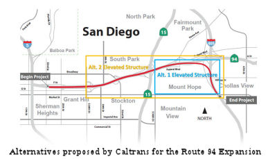
Route 94 / Route 125 Interchange (~ SD R9.651R to SD T11.5)
 In September 2000, the California Transportation
Commission considered a $1.7 million phase 1 proposal (TCRP Project #87)
for two new freeway connector ramps at the Route 94/Route 125 interchange.
Total estimated cost is $90 million. This funding was extended in
September 2005 as the project is ready to proceed. In April 2007, the CTC
amended project 87.2 to orogram an additional $3,610,000 in TCRP funds for
Project Approval & Environmental Document (PA&ED). This project
will construct the ultimate two-lane freeway-to-freeway connectors from
westbound Route 94 to northbound Route 125 and from southbound Route 125
to eastbound Route 94. The project will also widen Route 125 providing
additional lanes from Spring Street to Lemon Avenue, and provide auxiliary
lanes from the connectors to the next interchange at Lemon Avenue. The
additional $3,610,000 for PA&ED was needed to study impacts to the
large number of residential, commercial, and resource rich areas that will
be impacted by this project. It is estimated that four years will be
required to complete the needed environmental studies, complete the draft
environmental document, circulate it for public comment, and gain final
approval. The project is now scheduled for construction between FY 2012
and FY 2017.
In September 2000, the California Transportation
Commission considered a $1.7 million phase 1 proposal (TCRP Project #87)
for two new freeway connector ramps at the Route 94/Route 125 interchange.
Total estimated cost is $90 million. This funding was extended in
September 2005 as the project is ready to proceed. In April 2007, the CTC
amended project 87.2 to orogram an additional $3,610,000 in TCRP funds for
Project Approval & Environmental Document (PA&ED). This project
will construct the ultimate two-lane freeway-to-freeway connectors from
westbound Route 94 to northbound Route 125 and from southbound Route 125
to eastbound Route 94. The project will also widen Route 125 providing
additional lanes from Spring Street to Lemon Avenue, and provide auxiliary
lanes from the connectors to the next interchange at Lemon Avenue. The
additional $3,610,000 for PA&ED was needed to study impacts to the
large number of residential, commercial, and resource rich areas that will
be impacted by this project. It is estimated that four years will be
required to complete the needed environmental studies, complete the draft
environmental document, circulate it for public comment, and gain final
approval. The project is now scheduled for construction between FY 2012
and FY 2017.
TCRP Project #77 regarded an environmental study to add capacity to the Route 94 corridor between downtown San Diego to the Route 125 junction in Spring Valley. Currently, only the Alternative Analysis has been approved. The Alternative Analysis is to provide a thorough study of several alternative approaches to providing capacity enhancements. Study alternatives include, but are not limited to, reversible lanes, additional travel lanes (HOV and mixed flow), auxiliary lanes, and access improvement modifications. The environmental report/study will further evaluate the design alternatives from the Alternative Analysis. In 2002, San Diego Association of Governments (SANDAG) began development of an additional tax ordinance for transportation in the region, Transnet II. At the same time, SANDAG took the opportunity to study in greater detail both HOV lane needs and the development of Bus Rapid Transit routes throughout the region. As SANDAG’s studies impacted the Route 94 alternative study, the decision was made to postpone further work on the Alternative Analysis until final decisions were made by SANDAG. In November 2005, the San Diego voters passed Transnet II. With the Transnet II funds now available, interest in the Alternative Analysis has resumed in 2006 with SANDAG identifying several projects along the Route 94 corridor. The Department, working in conjunction with SANDAG, is now able to resume the Alternative Analysis study with greater knowledge of future improvements needed in the region and can proceed towards starting the environmental process.
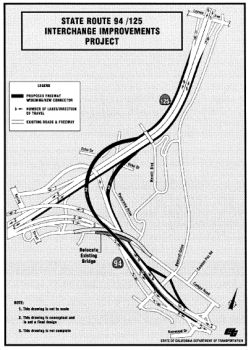
In August 2016, the CTC approved for future consideration of funding a project on Route 94 (11-SD-94, PM R10.5/T11.5) and Route 125 (11-SD-125, PM 13.6/14.6) in San Diego County that will construct a freeway-to-freeway connection from southbound Route 125 to eastbound Route 94 in the city of La Mesa. The project is not fully funded. The project is programmed in the Traffic Congestion Relief Program. The total estimated cost is $188,496,000 for capital and support. Depending on the availability of funding, construction is estimated to begin in Fiscal Year 2018-19. The Department has identified the need for a scope change to reduce the number of connectors from two to one. An amendment will be placed on the October 2016 California Transportation Commission meeting agenda to reflect the scope change.
In January 2017, it was reported that construction had
not yet commenced on this project, although some homes in the area had
been sold by Caltrans. A fact sheet from January 2016 noted that the
project encompasses two miles, with the freeway-to-freeway connector
passing under the existing Route 125 and joining eastbound Route 94
between Bancroft and Kenwood drives, according to the fact sheet.
Construction of two auxiliary lanes is planned: one lane along southbound
Route 125 from Lemon Avenue to the connector and the other lane from the
connector to Kenwood Drive. Other proposed improvements include replacing
the Mariposa Street overcrossing, widening the Route 94 bridges over
Bancroft Drive, constructing “bridge structures” on Panorama
Drive and Echo Drive over the connector, and constructing noise barriers
along Route 94 and Route 125. The estimated project cost totaled $71.33
million, with $5 million coming from the State Transportation Congestion
Relief Program and $1.7 million in TransNet funds from the San Diego
Association of Governments (SANDAG) for environmental studies.
(“TransNet,” says SANDAG’s website, “is the
half-cent sales tax for local transportation projects that was first
approved by voters in 1988, and extended in 2004 for another 40
years.”) However, “construction of these improvements will be
scheduled as funding becomes available.” In December 2016, Caltrans
project manager Lou Melendez responded, when asked about the status of the
project. “We stopped the project when we ran out of money.” He
said Caltrans funds ran out in 2015, and the project was “put on a
shelf.” Melendez said there was no funding because the
SANDAG-sponsored Measure A failed in November. In the year “2021,
things might improve”. The City of La Mesa is aware of the project
status, and that it is awaiting funding, said Greg Humora, the La Mesa
public works director/city engineer whose promotion to assistant city
manager was announced at the December 13, 2016 city-council meeting. On
December 15, Humora said the Route 125/Route 94 is the “number one
interchange project in the county” and identified by “TransNet
as a high-priority project.”
(Source: San Diego Reader, 1/18/2017)
In June 2017, the CTC authorized the following TCRP allocation: Allocation Amendment - TCRP Project. Request the reallocation of $536,000 for Environmental on TCRP Project 87.2 – Build two new freeway connector ramp projects in San Diego County. (PPNO 0356) [Approved.]: This is a financial re-allocation of $536,000 for TCRP Project 87.2 – Route 94/Route 125; build two new freeway connector ramps project (PPNO 0356) in San Diego County. Re-allocate $536,000 in previously allocated funds for PA&ED.
The 2018 STIP, approved at the CTC March 2018 meeting, appears to allocate Advance Project Development Element (APDE) funding of $7.948M in FY18-19 for PS&E on PPNO 0356 Route 94/Route 125 Connectors.
The 2020 STIP, approved at the CTC March 2020 meeting,
continued the programmed funding for PPNO 0356 "Rt 94/125 Connectors
(APDE)".
(Source: March 2020 CTC Agenda, Item 4.7, 2020 STIP
Adopted 3/25/2020)
In August 2020, the CTC approved an allocation of
$4,000,000 for the State-Administered Senate Bill 1 (SB 1) Local
Partnership Program (LPP) (Formulaic) Route 94/Route 125 Connector (PPNO
0356) project.
(Source: August 2020 CTC Agenda, Agenda Item
2.5s.(1))
 In April 2024, Caltrans held an Open House regarding this
project. The project is located in Spring Valley (unincorporated San Diego
County) and the City of La Mesa on Route 94 from Spring Street
Undercrossing to Kenwood Drive Undercrossing and on Route 125 from Spring
Street Undercrossing to Lemon Avenue Undercrossing. Caltrans proposes to
build the project in 2 phases. The original project extended more than 3
miles along both routes and made major improvements in the following
categories: (a) Auxiliary Lanes; (b) Bicycle, Pedestrian, and ADA
Improvements; and (c) Direct Freeway-to-Freeway Connector from Southbound
Route 125 to Eastbound Route 94. Phase 1 features Aux Lanes on Southbound
Route 125 (Lemon Avenue to Spring Street), on Eastbound Route 94 (Bancroft
to Kenwood Drive), and on Northbound Route 125 (Route 94 to Lemon Avenue).
The proposed auxiliary lanes will allow for easier merging onto the
freeway from local streets and greater storage to keep queuing off the
through lanes, improving freeway operations and safety. The Mariposa
Street Overcrossing will be replaced to accommodate the Route 125 aux
lanes. There would also be sound and retaining wall improvements to be
build along the aux lanes. The Mariposa Street Overcrossing Replacement
will be striped as a Class III Bikeway (Bike Route) by using sharrow
pavement markings to allow shared use of the lanes with motor vehicles,
and Spring Street and Bancroft Drive will be striped as a buffered Class
II Bikeway (Bike Lane) with a green-painted lane in each direction. The
Mariposa Street Overcrossing Replacement will have new 7’-wide
sidewalks on both sides and ADA-compliant curb ramps on all four corners.
Bancroft Drive will receive 6’-wide standard sidewalks and
ADA-compliant ramps at the eastbound ramps end. Phase 2 will feature a
freeway-to-freeway connector from Southbound Route 125 to Eastbound Route 94. The new connector will join eastbound Route 94 just west of the
eastbound offramp to Bancroft Drive. Currently, the portion of southbound
Route 125 between the Lemon Avenue onramp and the Spring Street offramp
carries approximately 83,400 vehicles a day, with an average of 20,550
vehicles a day exiting at Spring Street. The proposed connector would
eliminate the need for southbound Route 125 traffic to use Spring Street
to connect to eastbound Route 94, reducing queueing and delays for the
freeway and local street network and improving traffic flow, thus
increasing the level of safety and operations. The estimated total cost of
Phases 1 and 2 remains $240 million. Phase 1 is fully funded. Phase 1
Design and Environmental Reevaluation will be completed by summer 2025,
with Phase 1 Construction beginning shortly thereafter. Phase 2
Environmental will begin no later than June 2026. Phase 2 Design should
begin no later than June 2028.
In April 2024, Caltrans held an Open House regarding this
project. The project is located in Spring Valley (unincorporated San Diego
County) and the City of La Mesa on Route 94 from Spring Street
Undercrossing to Kenwood Drive Undercrossing and on Route 125 from Spring
Street Undercrossing to Lemon Avenue Undercrossing. Caltrans proposes to
build the project in 2 phases. The original project extended more than 3
miles along both routes and made major improvements in the following
categories: (a) Auxiliary Lanes; (b) Bicycle, Pedestrian, and ADA
Improvements; and (c) Direct Freeway-to-Freeway Connector from Southbound
Route 125 to Eastbound Route 94. Phase 1 features Aux Lanes on Southbound
Route 125 (Lemon Avenue to Spring Street), on Eastbound Route 94 (Bancroft
to Kenwood Drive), and on Northbound Route 125 (Route 94 to Lemon Avenue).
The proposed auxiliary lanes will allow for easier merging onto the
freeway from local streets and greater storage to keep queuing off the
through lanes, improving freeway operations and safety. The Mariposa
Street Overcrossing will be replaced to accommodate the Route 125 aux
lanes. There would also be sound and retaining wall improvements to be
build along the aux lanes. The Mariposa Street Overcrossing Replacement
will be striped as a Class III Bikeway (Bike Route) by using sharrow
pavement markings to allow shared use of the lanes with motor vehicles,
and Spring Street and Bancroft Drive will be striped as a buffered Class
II Bikeway (Bike Lane) with a green-painted lane in each direction. The
Mariposa Street Overcrossing Replacement will have new 7’-wide
sidewalks on both sides and ADA-compliant curb ramps on all four corners.
Bancroft Drive will receive 6’-wide standard sidewalks and
ADA-compliant ramps at the eastbound ramps end. Phase 2 will feature a
freeway-to-freeway connector from Southbound Route 125 to Eastbound Route 94. The new connector will join eastbound Route 94 just west of the
eastbound offramp to Bancroft Drive. Currently, the portion of southbound
Route 125 between the Lemon Avenue onramp and the Spring Street offramp
carries approximately 83,400 vehicles a day, with an average of 20,550
vehicles a day exiting at Spring Street. The proposed connector would
eliminate the need for southbound Route 125 traffic to use Spring Street
to connect to eastbound Route 94, reducing queueing and delays for the
freeway and local street network and improving traffic flow, thus
increasing the level of safety and operations. The estimated total cost of
Phases 1 and 2 remains $240 million. Phase 1 is fully funded. Phase 1
Design and Environmental Reevaluation will be completed by summer 2025,
with Phase 1 Construction beginning shortly thereafter. Phase 2
Environmental will begin no later than June 2026. Phase 2 Design should
begin no later than June 2028.
(Source: Caltrans Project Page, dated April 2023)
In June 2025, the CTC approved an amendment
reprogramming STIP funds: The Route 94/Route 125 Auxiliary Lanes project
(PPNO 0356) is currently programmed in the 2024 STIP with $85,000,000 in
RIP funds for the CON phase in 2026-27. Initially, the project intended to
build auxiliary lanes on Route 94 and Route 125 in addition to a
connector. However, high contaminated groundwater levels were encountered
at the planned connector's location, which would require continuous
dewatering and treatment before discharging. Therefore, a project change
request was processed in March 2025 to down-scope the project by removing
the Connector work, which will now be delivered under PPNO 1541, and
moving forward with the auxiliary lanes project scope. As a result, the
Route 94/Route 125 Auxiliary Lanes project will be ready to start
construction earlier, and the Department recommends reprogramming the
funds from the CON phase from 2026-27 to 2025-26.
(Source: June 2025 CTC Agenda, Agenda Item 2.1a.(3) #10)
In June 2025, the CTC approved the following LPP
(Formulaic) – Allocation Amendment: $4,000,000 $853,000.
11-SD-94 10.0/11.8. PPNO 11-0356; ProjID 1100000078; EA 14665. Route 94/125 Connector. In Lemon Grove at Route 94/Route 125 Interchange.
Construct southbound Route 125 to eastbound Route 94 freeway connector
ramp. Future consideration of funding approved under Resolution E-16-58;
August 2016. Related LPP Program Amendment approved under Resolution
LPP-P-2021-02; August 2020. Contribution from other sources: $7,946,000.
Concurrent STIP Amendment under 24S-03; June 2025. Amend Resolution
LPP-A-2021-01 to deallocate $147,000 in RW Support and $3,000,000 in RW
Capital due to the funds lapsing. Allocation changes: LPP-F/20-21 ⇒
R/W Sup $1,000,000 $853,000; LPP-F/20-21 ⇒
R/W Sup $3,000,000 $0.
(Source: June 2025 CTC Agenda, Agenda Item 2.5s.(8))
In March 2026, the CTC adopted the 2026 STIP, which
included the following as continued programming from 2024: PPNO 11-0356,
“Rt94 Spring-Kenwood/Rt125 Spring-Lemon, Aux Lns(24S-03)”.
Total Programmed ($×1000): $98,948. Prior years programming
($×1000): $98,948. 2026 and Future Programming ($×1000): $0.
Programming Breakdown ($×1000): $0 (PA&ED), $13,948 (PS&E),
$71,000 (Const), $14,000 (Con Sup), $0 (R/W), $0 (R/W Sup).
(Source: March 2026 CTC Agenda, Agenda Item 4.4; 2026 STIP Staff Recommendations Adopted 2/27/2026)
In March 2026, the CTC adopted the 2026 STIP, which
included the following as continued programming from 2024: PPNO 11-1541,
“IC & Arterial Opr Imprvmnts -Fwy Connect, BikePed
Rt94-Rt125”. Total Programmed ($×1000): $16,000. Prior years
programming ($×1000): $6,000. 2026 and Future Programming
($×1000): $10,000 FY27-28. Programming Breakdown ($×1000):
$6,000 (PA&ED), $10,000 (PS&E), $0 (Const), $0 (Con Sup), $0
(R/W), $0 (R/W Sup).
(Source: March 2026 CTC Agenda, Agenda Item 4.4; 2026 STIP Staff Recommendations Adopted 2/27/2026)
In June 2026, the CTC approved the following
allocation: $84,900,000. 11-SD-94 R10.3/R11.9; 11-SD-125 13.6/14.6. PPNO
11-0356; ProjID 1100000078; EA 14665. SR 94/125 Auxiliary Lanes.
In San Diego County in and near La Mesa on Route 94 from Spring Street
undercrossing to 0.1 mile east of Kenwood Drive undercrossing and on Route 125 from 0.2 mile south of Spring Street undercrossing to 0.2 mile north
of Lemon Avenue undercrossing. Construct NB Route 125, SB Route 125, and
EB Route 94 auxiliary lanes. CEQA - MND, 12/16/2015; Re-validation
02/23/2026. NEPA - FONSI, 12/16/2015; Re-validation 02/23/2026. Future
consideration of funding approved under Resolution E-16-58; August 2016.
Right of Way Certification: 04/02/2026. As part of this allocation
request, the Department requested to extend the completion of CONST and
CON ENG an additional 6 months beyond the 36-month deadline. Construction
Phase Allocation ($ × $1000): Budgeted (Actual, if different):
Con Sup/CON ENG $14,000 ($13,900); Const $71,000.
(Source: June 2026 CTC Agenda, Agenda Item 2.5c.(5))
In December 2016, the CTC authorized relinquishment of right of way in the city of La Mesa along Route 125 on Bowling Green Drive and Echo Drive (11-SD-125-PM 13.5/14.0) and along Route 94 on Panorama Drive (11-SD-94-PM 10.5/10.8), consisting of collateral facilities. The City, by letter dated August 1, 2016, agreed to waive the 90-day notice requirement and accept title upon relinquishment by the State.
Route 125 near Spring Valley to Route 188 near Tecate
In March 2012, the CTC authorized SHOPP funding on Route 94, in San Diego County, 11-SD-94 13.8/14.4 Near Lemon Grove, from Via Mercado Road to 0.1 mile east of Jamacha Boulevard. $1,600,000 to construct median barrier to improve safety by reducing cross centerline collisions.
In March 2013, the CTC authorized $13,008,000 to rehabilitate 30 lane miles of pavement to extend service life and improve ride quality for the segment near Jamul, from Route 54 to 0.2 miles east of Marron Valley Road (~ SD 14.927 to SD 30.069).
In December 2014, the CTC authorized relinquishment of right of way in the county of San Diego on superseded Route 94 (Old Campo Road) between Miller Ranch Road and Fair Oaks Drive near Jamacha (~ SD 15.515, SD R16.963), consisting of superseded highway right of way. The County, by letter dated October 9, 2014, agreed to waive the 90-day notice requirement and accept title upon relinquishent by the State.
In October 2012, the CTC authorized relinquishment of right of way in the county of San Diego along Route 94 at Steele Canyon Road (near Jamacha) (~ SD 17.351), consisting of collateral facilities.
In August 2017, it was reported that the Jamul Indian Village has given
$1.1 million to the county to go toward traffic improvements along Route 94 (~ SD 20.652 to SD 22.711). The money is part of $3.4 million the tribe
has pledged toward safety measures along the dark, winding highway in
rural East County. The Jamul group and the county last April signed a
contract that guaranteed that the tribe would commit $23 million to
Caltrans to improve conditions issues along Route 94. The tribe also
agreed to an additional $3.7 million in funding to the county for
improvements. The tribe has promised more than $120 million altogether for
public safety, law enforcement, transportation and firefighting for te
residents and roads around its Hollywood Casino Jamul-San Diego. A news
release sent Thursday from the Jamul tribe notes that it was recently
informed that Caltrans “is unable to take the lead role on these
highway improvements.” The tribe says it will now coordinate
directly with the county for roadway improvements. Cathryne Bruce-Johnson,
spokeswoman for Caltrans, said that the state agency “is not party
to the Intergovernmental Agreement between the county of San Diego and the
Jamul Indian Village for off-reservation roadway improvements.”
(Source: San Diego U-T, 8/25/2017)
Roadway Realignment near Dulzura (SD 20.7/SD 38.9)
![[Improvements]](maps/094-improvements.jpg) In
November 2007, the CTC received notice of preparation of an EIR regarding
construction of roadway improvements including adding passing lanes and
upgrading existing lanes and shoulders to current standards on Route 94
near Dulzura in San Diego County between PM SD 20.7 and PM SD 38.9. The
project is fully funded in the 2006 State Transportation Improvement
Program, Congestion Mitigation Air Quality Program and San Diego’s
Association of Governments Transnet Program. The total estimated project
cost is $56 million. Construction is estimated to begin in Fiscal Year
(FY) 2010-11.
In
November 2007, the CTC received notice of preparation of an EIR regarding
construction of roadway improvements including adding passing lanes and
upgrading existing lanes and shoulders to current standards on Route 94
near Dulzura in San Diego County between PM SD 20.7 and PM SD 38.9. The
project is fully funded in the 2006 State Transportation Improvement
Program, Congestion Mitigation Air Quality Program and San Diego’s
Association of Governments Transnet Program. The total estimated project
cost is $56 million. Construction is estimated to begin in Fiscal Year
(FY) 2010-11.
In October 2016, the CTC amended the SHOPP as follows: 11-SD-94 29.6/29.8 | Route 94 Near Dulzura, from north of Marron Valley Road to south of Dutchman Canyon Road. Roadway realignment, curve improvement, and shoulder widening. During preliminary design, the excavation boundary increased. This will result in additonal easement and acquisition areas. Furthermore, to allow for future maintenance for proposed drainage outlets, additional utility relocations and access easements are required. These changes add $154,000 to the cost of the project.
In August 2018, the CTC authorized $4,711,000 in SHOPP
funding for San Diego 11-SD-94 29.4/29.7: Route 94 Near Dulzura, from 0.3
mile east of Grande Creek Bridge to 0.1 mile west of Marron Valley Road.
Outcome/Output: Roadway realignment, curve improvement, and shoulder
widening. This project will increase safety and reduce the number and
severity of collisions.
(Source: August 2018 CTC Agenda Item 2.5f.(3) Item
18)
In May 2015, the CTC authorized relinquishment of right of way in the county of San Diego along Route 94 at Community Building Road (near Engineering Springs, S of Dulzura) (~ SD 30.608), consisting of a reconstructed county road. It also authorized vacation of right of way in the county of San Diego along Route 94 at Community Building Road, consisting of highway right of way no longer needed for State highway purposes.
Route 188 near Tecate to I-8 near In-Co-Pah Park via Campo and Jacumba Hot Springs
In August 2016, the CTC approved $3,450,000 for Route 94 near Campo, at Campo Creek Bridge No. 57-0120. Following a recent bridge inspection, it was concluded this bridge needs replacement due to extensive deterioration of the existing deck and timber stringers and the potential high scour threat to the bridge foundations. Temporary shoring has been installed; however, shoring could fail as a result of monsoonal rainstorms and flash floods, thus placing the bridge at risk of collapse. This project will demolish the existing bridge and construct new to current standards. (The new bridge appears to be 57-1259, constructed in 2016, at SD 050.64; the other two Campo Creek bridges date to 1947 and 1964)
The SAFETEA-LU act, enacted in August 2005 as the reauthorization of TEA-21, provided an expenditure for High Priority Project #1639: Resurface and construct truck lane at Route 94 and I-8 interchange. $2,400,000 . (SD 065.37)
 Naming
 The portion of this route between Route 5 and Route 125 (~ SD 1.554 and SD R9.614) is
named the "Martin Luther King Jr. Freeway". It was named by Senate
Concurrent Resolution 67, Chapter 129, in 1989. Martin Luther King, Jr.,
(January 15,1929-April 4, 1968) was a seminal figure in the battle for
civil rights in the United States. Martin Luther attended segregated
public schools in Georgia, graduating from high school at the age of
fifteen; he received the B. A. degree in 1948 from Morehouse College, a
distinguished Negro institution of Atlanta from which both his father and
grandfather had been graduated. After three years of theological study at
Crozer Theological Seminary in Pennsylvania where he was elected president
of a predominantly white senior class, he was awarded the B.D. in 1951.
With a fellowship won at Crozer, he enrolled in graduate studies at Boston
University, completing his residence for the doctorate in 1953 and
receiving the degree in 1955. In 1954, Martin Luther King accepted the
pastorale of the Dexter Avenue Baptist Church in Montgomery, Alabama. In
December, 1955, he led the first great Negro nonviolent demonstration of
contemporary times in the United States, the bus boycott in Atlanta. In
1957 he was elected president of the Southern Christian Leadership
Conference. In the eleven-year period between 1957 and 1968, King traveled
over six million miles and spoke over twenty-five hundred times, appearing
wherever there was injustice, protest, and action; and meanwhile he wrote
five books as well as numerous articles. He was named Man of the Year by
Time magazine in 1963; and became not only the symbolic leader of American
blacks but also a world figure. At the age of thirty-five, Martin Luther
King, Jr., became the youngest man to have received the Nobel Peace Prize.
When notified of his selection, he announced that he would turn over the
prize money of $54,123 to the furtherance of the civil rights movement. On
the evening of April 4, 1968, while standing on the balcony of his motel
room in Memphis, Tennessee, where he was to lead a protest march in
sympathy with striking garbage workers of that city, he was assassinated.
The portion of this route between Route 5 and Route 125 (~ SD 1.554 and SD R9.614) is
named the "Martin Luther King Jr. Freeway". It was named by Senate
Concurrent Resolution 67, Chapter 129, in 1989. Martin Luther King, Jr.,
(January 15,1929-April 4, 1968) was a seminal figure in the battle for
civil rights in the United States. Martin Luther attended segregated
public schools in Georgia, graduating from high school at the age of
fifteen; he received the B. A. degree in 1948 from Morehouse College, a
distinguished Negro institution of Atlanta from which both his father and
grandfather had been graduated. After three years of theological study at
Crozer Theological Seminary in Pennsylvania where he was elected president
of a predominantly white senior class, he was awarded the B.D. in 1951.
With a fellowship won at Crozer, he enrolled in graduate studies at Boston
University, completing his residence for the doctorate in 1953 and
receiving the degree in 1955. In 1954, Martin Luther King accepted the
pastorale of the Dexter Avenue Baptist Church in Montgomery, Alabama. In
December, 1955, he led the first great Negro nonviolent demonstration of
contemporary times in the United States, the bus boycott in Atlanta. In
1957 he was elected president of the Southern Christian Leadership
Conference. In the eleven-year period between 1957 and 1968, King traveled
over six million miles and spoke over twenty-five hundred times, appearing
wherever there was injustice, protest, and action; and meanwhile he wrote
five books as well as numerous articles. He was named Man of the Year by
Time magazine in 1963; and became not only the symbolic leader of American
blacks but also a world figure. At the age of thirty-five, Martin Luther
King, Jr., became the youngest man to have received the Nobel Peace Prize.
When notified of his selection, he announced that he would turn over the
prize money of $54,123 to the furtherance of the civil rights movement. On
the evening of April 4, 1968, while standing on the balcony of his motel
room in Memphis, Tennessee, where he was to lead a protest march in
sympathy with striking garbage workers of that city, he was assassinated.
(Biography excerpted from the information on the Nobel Prize site; more information is also available at The King Center; Image sources: AAroads, Biography.Com)
Until 1989, it was named the "Helix Freeway". This is named after nearby Mt. Helix, which itself was named after the local Helix species of snail. This probably has something to do with its spiraling base. The mountain's peak is 1,370'. Mt. Helix appears on the La Mesa city seal, and the name is applied to various landmarks and roads
The portion of this route E of Rout 125 (~ SD R9.614 to SD R13.529) is informally named the "Campo Freeway".
 The portion of this route between Bancroft Drive and Avocado Boulevard in the County of San Diego (~ SD
R11.09 to SD R13.367) is offically named the "James Craig Schmidt
Memorial Highway." It was named in memory of James Craig Schmidt,
who was born in 1927, in Peoria, Illinois. After graduating from high
school, Schmidt enlisted in the United States Navy, and later attended
Illinois Wesleyan University, the University of Illinois, and De Paul
University Law School, becoming a member of the Illinois State Bar and
later the California State Bar. In 1958, Mr. Schmidt moved to San Diego,
married, and began his career in the savings and loan industry, becoming
legal counsel and senior vice president with Home Federal Savings and Loan
before later joining San Diego Federal Savings and Loan as executive vice
president-managing officer. In 1967, Mr. Schmidt was appointed as
Assistant Secretary for Business and Transportation under Governor Reagan,
and was later appointed to the California Toll Bridge Authority and the
State Transportation Board. Mr. Schmidt was involved in local
transportation issues for many years in the County of San Diego, was
instrumental in the removal of tolls from the San Diego-Coronado Bridge,
and was a long-time board member of the San Diego Highway Development
Association and the first recipient of its lifetime achievement award in
2011. Mr. Schmidt had a distinguished record of community service, as a
member of many organizations and the recipient of numerous awards,
including the designation by the City of San Diego of a James C. Schmidt
Day in 2000 for his service and dedication to the city. As an avid sports
fan, Mr. Schmidt attended every game of the San Diego Chargers from the
date of their first game in San Diego in 1961, and helped launch the first
Holiday Bowl in San Diego in 1978 and served as President of the 1986
Holiday Bowl and Chairman of the 1987 Holiday Bowl. Further, as a guest
commentator for the Daily Transcript, Mr. Schmidt wrote regular articles
on a wide variety of topics, including sports, transportation, housing,
real estate, desalinization, and grand jury reports, helping to educate
readers and document local history. James Craig Schmidt died of cancer in
January 2013. Named on 9/27/13 by ACR 57, Res. Chapter 136, Statutes of
2013.
The portion of this route between Bancroft Drive and Avocado Boulevard in the County of San Diego (~ SD
R11.09 to SD R13.367) is offically named the "James Craig Schmidt
Memorial Highway." It was named in memory of James Craig Schmidt,
who was born in 1927, in Peoria, Illinois. After graduating from high
school, Schmidt enlisted in the United States Navy, and later attended
Illinois Wesleyan University, the University of Illinois, and De Paul
University Law School, becoming a member of the Illinois State Bar and
later the California State Bar. In 1958, Mr. Schmidt moved to San Diego,
married, and began his career in the savings and loan industry, becoming
legal counsel and senior vice president with Home Federal Savings and Loan
before later joining San Diego Federal Savings and Loan as executive vice
president-managing officer. In 1967, Mr. Schmidt was appointed as
Assistant Secretary for Business and Transportation under Governor Reagan,
and was later appointed to the California Toll Bridge Authority and the
State Transportation Board. Mr. Schmidt was involved in local
transportation issues for many years in the County of San Diego, was
instrumental in the removal of tolls from the San Diego-Coronado Bridge,
and was a long-time board member of the San Diego Highway Development
Association and the first recipient of its lifetime achievement award in
2011. Mr. Schmidt had a distinguished record of community service, as a
member of many organizations and the recipient of numerous awards,
including the designation by the City of San Diego of a James C. Schmidt
Day in 2000 for his service and dedication to the city. As an avid sports
fan, Mr. Schmidt attended every game of the San Diego Chargers from the
date of their first game in San Diego in 1961, and helped launch the first
Holiday Bowl in San Diego in 1978 and served as President of the 1986
Holiday Bowl and Chairman of the 1987 Holiday Bowl. Further, as a guest
commentator for the Daily Transcript, Mr. Schmidt wrote regular articles
on a wide variety of topics, including sports, transportation, housing,
real estate, desalinization, and grand jury reports, helping to educate
readers and document local history. James Craig Schmidt died of cancer in
January 2013. Named on 9/27/13 by ACR 57, Res. Chapter 136, Statutes of
2013.
(Image source: Legacy.Com)
 The portion of this route between Old Campo Road and Melody Road in the County of San Diego (~ SD R16.5 to
SD 20.653) is officially named the Stephen Palmer, Sr. Memorial
Highway. It was named in memory of Caltrans Imperial Landscape Crew
member Stephen Palmer, Sr., was born in 1946, in Lima, Peru. Palmer served
in the United States Navy from July 21, 1964, to November 22, 1967.
Stephen Palmer, Sr., began working for the Department of Transportation
(Caltrans) in 2007, where he quickly worked his way into playing an
integral role and became a proud member of Caltrans District 11’s
Imperial Landscape Crew. Palmer died from injuries sustained after being
struck by a trolley car in the National City area of San Diego while on
the job on May 4, 2011. Working for Caltrans runs in the family; Palmer's
son, Stephen Palmer, Jr., also works for Caltrans District 11 Maintenance.
It was named by SCR 83, chaptered 2/3/2014, Resolution Chapter 3.
The portion of this route between Old Campo Road and Melody Road in the County of San Diego (~ SD R16.5 to
SD 20.653) is officially named the Stephen Palmer, Sr. Memorial
Highway. It was named in memory of Caltrans Imperial Landscape Crew
member Stephen Palmer, Sr., was born in 1946, in Lima, Peru. Palmer served
in the United States Navy from July 21, 1964, to November 22, 1967.
Stephen Palmer, Sr., began working for the Department of Transportation
(Caltrans) in 2007, where he quickly worked his way into playing an
integral role and became a proud member of Caltrans District 11’s
Imperial Landscape Crew. Palmer died from injuries sustained after being
struck by a trolley car in the National City area of San Diego while on
the job on May 4, 2011. Working for Caltrans runs in the family; Palmer's
son, Stephen Palmer, Jr., also works for Caltrans District 11 Maintenance.
It was named by SCR 83, chaptered 2/3/2014, Resolution Chapter 3.
(Image source: Caltrans In Remembrance Page)
 The portion of Route 94 from post mile SD 24.50 to SD 29.50 in the
County of San Diego is named the "Border Patrol Agent Jarod Charles
Dittman Memorial Highway". It was named in memory of Jarod Charles
Dittman, who was born in September 1979, in the City of Fargo, North
Dakota and graduated from Philipsburg-Osceola High School in 1998. He
later went on to graduate from Pennsylvania State University and became a
member of a Civil War reenactment group, the 148th Pennsylvania Volunteer
Infantry, Company C. Jarod served in the Pennsylvania Army National Guard
and was later deployed to Kosovo, where he observed that the children
there were in need of winter clothing. He orchestrated a drive to collect
coats and boots in the United States and had them distributed throughout
the countryside around Kosovo. Jarod continued in his service to his
country and began his career as a Border Patrol Agent for the United
States Department of Homeland Security on March 5, 2007, as a member of
the 660th Session of the Border Patrol Academy. He was assigned to the
Brown Field Station immediately after graduation from the academy and
loved his career and his fellow agents. On March 30, 2008, while Border
Patrol Agent Dittman was working the midnight shift, he was involved in a
single vehicle rollover accident at approximately 1:00 a.m. in the morning
when he was en route to his assigned work area from the Brown Field
Station. Agent Dittman was found by another border patrol agent after he
had been ejected from his service vehicle. Border Patrol Agent Jarod
Charles Dittman was 28 years of age at the time of his death and is
survived by his wife and his daughter. Named by Assembly Concurrent
Resolution (ACR) 154, 8/17/2018.
The portion of Route 94 from post mile SD 24.50 to SD 29.50 in the
County of San Diego is named the "Border Patrol Agent Jarod Charles
Dittman Memorial Highway". It was named in memory of Jarod Charles
Dittman, who was born in September 1979, in the City of Fargo, North
Dakota and graduated from Philipsburg-Osceola High School in 1998. He
later went on to graduate from Pennsylvania State University and became a
member of a Civil War reenactment group, the 148th Pennsylvania Volunteer
Infantry, Company C. Jarod served in the Pennsylvania Army National Guard
and was later deployed to Kosovo, where he observed that the children
there were in need of winter clothing. He orchestrated a drive to collect
coats and boots in the United States and had them distributed throughout
the countryside around Kosovo. Jarod continued in his service to his
country and began his career as a Border Patrol Agent for the United
States Department of Homeland Security on March 5, 2007, as a member of
the 660th Session of the Border Patrol Academy. He was assigned to the
Brown Field Station immediately after graduation from the academy and
loved his career and his fellow agents. On March 30, 2008, while Border
Patrol Agent Dittman was working the midnight shift, he was involved in a
single vehicle rollover accident at approximately 1:00 a.m. in the morning
when he was en route to his assigned work area from the Brown Field
Station. Agent Dittman was found by another border patrol agent after he
had been ejected from his service vehicle. Border Patrol Agent Jarod
Charles Dittman was 28 years of age at the time of his death and is
survived by his wife and his daughter. Named by Assembly Concurrent
Resolution (ACR) 154, 8/17/2018.
(Image source: 10 News, Find a Grave)
 The portion of Route 94 from Potrero Valley Road (SD 41.393) to Bell Valley
Truck Trail (SD R44.96) in the County of San Diego is designated the
“Border Patrol Agent Daniel H. Salazar Memorial Highway”.
Daniel “Danny” Humberto Salazar was born in May 1982 in Los
Angeles County. He grew up in Downey, and had a passion for music and, as
a self-taught musician, played the guitar, bass guitar, ukulele, piano,
and his specialty, drums. After high school, Danny attended Río Hondo
College in the City of Whittier, graduated from the college with an
associate of science degree, and successfully passed an emergency medical
technician training program. He was a volunteer firefighter for the City
of Downey and completed several ridealongs with the Los Angeles and Long
Beach Fire Departments. He attended a rigorous wildland fire academy in
the County of San Diego and worked for the wildland fire crew in the
County of Lassen. He attended the Los Angeles Fire Department Leadership
Academy but had to step down from his position due to an injury suffered
during training. He later applied to be a United States Border Patrol
Agent; and after completing the 19-week United States Border Patrol
Academy, graduated as a member of Class 1097 on December 7, 2018, and
received an official offer to begin his career as a border agent at the
United States Customs and Border Protection’s El Cajon Station. On
May 13, 2022, while he was responding to a sensor activation, Danny passed
away from injuries sustained in an on-duty single vehicle crash on a
border road near Potrero, south of Bell Valley. Named by ACR 81, Res.
Chapter 50, Statutes of 2026, 4/28/2026.
The portion of Route 94 from Potrero Valley Road (SD 41.393) to Bell Valley
Truck Trail (SD R44.96) in the County of San Diego is designated the
“Border Patrol Agent Daniel H. Salazar Memorial Highway”.
Daniel “Danny” Humberto Salazar was born in May 1982 in Los
Angeles County. He grew up in Downey, and had a passion for music and, as
a self-taught musician, played the guitar, bass guitar, ukulele, piano,
and his specialty, drums. After high school, Danny attended Río Hondo
College in the City of Whittier, graduated from the college with an
associate of science degree, and successfully passed an emergency medical
technician training program. He was a volunteer firefighter for the City
of Downey and completed several ridealongs with the Los Angeles and Long
Beach Fire Departments. He attended a rigorous wildland fire academy in
the County of San Diego and worked for the wildland fire crew in the
County of Lassen. He attended the Los Angeles Fire Department Leadership
Academy but had to step down from his position due to an injury suffered
during training. He later applied to be a United States Border Patrol
Agent; and after completing the 19-week United States Border Patrol
Academy, graduated as a member of Class 1097 on December 7, 2018, and
received an official offer to begin his career as a border agent at the
United States Customs and Border Protection’s El Cajon Station. On
May 13, 2022, while he was responding to a sensor activation, Danny passed
away from injuries sustained in an on-duty single vehicle crash on a
border road near Potrero, south of Bell Valley. Named by ACR 81, Res.
Chapter 50, Statutes of 2026, 4/28/2026.
 Historical Route
Route 94 from the junction of Jamacha Road in Rancho San Diego to the eastern terminus at the junction with Historic Highway Route 80 in Boulevard (~ SD 14.83 to SD R64.125) has been designated as “Historic Highway Route 94” This naming recognizes the history of Route 94. Route 94 was previously known as Campo Road or Old Route 200, which began as foot trails, and with great labor was improved to accommodate wagons and stagecoaches and, until 1918, was the main artery road from San Diego, California to Yuma, Arizona. In 1829, the trails provided access to the Jamul Rancho owned by Governor Don Pio Pico. In the 1880s, Campo Road provided necessary and difficult access for the backcountry pioneers to San Diego to sell their products and secure needed supplies. The first telegraph line from San Diego to Arizona followed the general route of Campo Road in 1874. The first horseless carriage trip on Campo Road from San Diego to Campo and back was made in 1904 by John Gay of Lakeside The early Campo Road was used by the United States Military during the Mexican Revolution in 1911, during World War I, and extensively during World War II for support of Camp Lockett located in Campo. Camp Lockett was the last home of the famous Buffalo Soldiers of the 10th Cavalry of the United States Army. On August 21, 1933, the title to Old Route 200 was transferred to the State of California and renamed Route 94. The beginning of Highway Route 94 at the time of transfer was in Lemon Grove at North Avenue and Imperial Avenue (now Lemon Grove Avenue), continuing through Spring Valley, Jamul, Dulzura, Cottonwood Grade, Potrero Grade, to Campo, then easterly along CampCreek and terminating at the junction of Route 12 at White Star, a total distance of about 66 miles. The San Diego and Arizona Railway, the last transcontinental rail link built in the United States, which was completed in 1919, crosses Route 94 in five locations, two at grade and three by bridge, and generally follows Route 94 all the way to Yuma. Named by Assembly Concurrant Resolution (ACR) 131, 6/2/2010, Resolution Chapter 33.
 ACR 123 (Resolution Chapter 104, 8/16/2006) designated segments of former U.S. Highway Route 80 in San Diego and Imperial Counties as Historic
U.S. Highway Route 80, and requested the Department of
Transportation to design and facilitate the posting of appropriate signs
and take related actions in that regard. The resolution noted that US 80,
largely parallel to current I-8, was a 180-mile highway spanning San Diego
and Imperial Counties from San Diego Bay to the Colorado River, and played
a major role in the development of this state during much of the 20th
century. In 1909, California voters approved a statewide bond measure for
road improvement purposes in the amount of $18 million, providing, among
other things, funds to construct a road between San Diego and Imperial
Counties, and their county seats of San Diego and El Centro. In 1915, a
unique wood plank road was built over the Imperial Valley sand hills,
resulting in a shorter route. In 1925, the federal government became
involved in standardized highway route designations across the nation and
even numbers were assigned to major highways running east and west, and
odd numbers for highway running north and south. The numbering of highways
proceeded in numerical order beginning in the north and east and
continuing south and west, respectively, and, as a result, the routing
along California's southern border was formally designated as US 80. This
road, from San Diego to Tybee Island, Georgia, was adopted as US 80 on
November 11, 1926. US 80 was the first ocean-to-ocean transcontinental
highway to be completed, and portions of the route were known as the
Bankhead, Broadway of America, Dixie, Lee, Old Spanish Trail, and Southern
Transcontinental Highway.
ACR 123 (Resolution Chapter 104, 8/16/2006) designated segments of former U.S. Highway Route 80 in San Diego and Imperial Counties as Historic
U.S. Highway Route 80, and requested the Department of
Transportation to design and facilitate the posting of appropriate signs
and take related actions in that regard. The resolution noted that US 80,
largely parallel to current I-8, was a 180-mile highway spanning San Diego
and Imperial Counties from San Diego Bay to the Colorado River, and played
a major role in the development of this state during much of the 20th
century. In 1909, California voters approved a statewide bond measure for
road improvement purposes in the amount of $18 million, providing, among
other things, funds to construct a road between San Diego and Imperial
Counties, and their county seats of San Diego and El Centro. In 1915, a
unique wood plank road was built over the Imperial Valley sand hills,
resulting in a shorter route. In 1925, the federal government became
involved in standardized highway route designations across the nation and
even numbers were assigned to major highways running east and west, and
odd numbers for highway running north and south. The numbering of highways
proceeded in numerical order beginning in the north and east and
continuing south and west, respectively, and, as a result, the routing
along California's southern border was formally designated as US 80. This
road, from San Diego to Tybee Island, Georgia, was adopted as US 80 on
November 11, 1926. US 80 was the first ocean-to-ocean transcontinental
highway to be completed, and portions of the route were known as the
Bankhead, Broadway of America, Dixie, Lee, Old Spanish Trail, and Southern
Transcontinental Highway.
 Exit Information
 Other WWW Links
 Scenic Route
[SHC 263.5] From Route 125 near Spring Valley to Route 8 west of Jacumba.
Although this segment is eligible for Scenic Highway status, it has not yet met the criteria to be officially designated as Scenic Highway.
 Classified Landcaped Freeway
The following segments are designated as Classified Landscaped Freeway:
| County | Route | Starting PM | Ending PM |
| San Diego | 94 | 1.41 | 5.99 |
| San Diego | 94 | 6.15 | 8.77 |
| San Diego | 94 | 9.23 | 10.50 |
| San Diego | 94 | R10.99 | R11.40 |
 Commuter Lanes
 Freeway
[SHC 253.5] From Route 5 near San Diego to 0.3 miles east of Sweetwater Bridge. Constructed to freeway standards from Route 5 to 2 mi W of Route 54. The portion from Route 5 to Route 54 near Jamacha Road was added to the Freeway and Expressway system in 1959. A revised designation (Route 5 to 0.3 miles east of the Sweetwater Bridge) was defined in 1992.
 National Trails
  This route was part of the "Old Spanish Trail". You can see it on an early 1923 map at the OST100 web site. Campo on the map is now on Route 94. The 1924 and 1925 maps no
longer show Campo, and by 1926 when the federal highways came into
existence, Campo is replaced by Alpine (the US 80 alignment).
This route was part of the "Old Spanish Trail". You can see it on an early 1923 map at the OST100 web site. Campo on the map is now on Route 94. The 1924 and 1925 maps no
longer show Campo, and by 1926 when the federal highways came into
existence, Campo is replaced by Alpine (the US 80 alignment).
 Statistics
Overall statistics for Route 94:
 Pre-1964 Legislative Route
In 1933, the route from "[LRN 38] near Camp Richardson to S end Fallen Leaf Lake" was defined to be a state highway. In 1935, that route was codified as LRN 94, and retained that definition until 1963. It ran from Route 89 near Camp Richardson to the south end of Fallen Leaf Lake, and was signed as Route 188 between 1964 and 1965. This was defined in 1933.
In a discussion on AARoads in June 2017, Sparker noted: Sometimes the reason for maintaining one of the old and otherwise useless LRN's was less than either noble or commercially viable; an example of this was old LRN 94, which ran from Route 89 near Richardson Bay near the south side of Emerald Bay up the hill to Fallen Leaf (about 4 miles), which was a small area comprised of a series of lodges; while the ownership of these was private, the lodges were often used for off-the-books conferences and/or political meetings by state officials (including legislators) and lobbyists or other entities desiring face-to-face meetings with those officials away from public scrutiny. The LRN was kept maintained and plowed during winter to expedite these "conferences"—which according to "underground" Division of Highways lore, often morphed into multi-day poker games and/or drinking fests! By the early '60's, the usage of the facilities had declined to the point that state maintenance was no longer a "perk", so the 1965 deletion of numerous marginal routes (after '64 LRN 94 became the original Route 188) was applied to this one as well, with the Route 188 number re-used in San Diego County as the Tecate border access route some years later.
© 1996-2024 Daniel P. Faigin.
Maintained by: Daniel P. Faigin
<webmaster@cahighways.org>.
 From Route
  Route 93
 Route 95