
 California Highways:
Click here for a key to the symbols used. An explanation of acronyms may be found at the bottom of the page.
 Routing
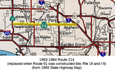 No current routing.
 Post 1964 Signage History
 In 1963, Route 214 was defined as the route from "Route 19 near
Lakewood to Route 5 near Anaheim." This routing ran along Carson and
Lincoln Blvds.
In 1965, Chapter 1372 added the condition that "this route shall cease to be a state highway when Route 91 freeway is completed from Route 19 to Route 5 and the commission relinquishes that portion of present Route 91 from Route 19 to Route 5."
In 1981, Chapter 292 deleted the routing.
 Pre 1964 Signage History
The 1964-1981 routing was the old surface street routing of Sign Route 18/US 91 (pre-1963 Sign Route 15) along Lincoln Avenue between US 101 (present-day I-5) and Sign Route 19. This was LRN 178.
LRN 178 was defined in 1933 as "Cerritos Avenue to [LRN 43] near Olive
via Anaheim" Cerritos Avenue was later renamed Lakewood Avenue; LRN 43 was
to become Sign Route 18 (briefly) and then US 91. The route followed
Carson Street, Lincoln Avenue and Center Street (now Lincoln Avenue in
Anaheim) between Lakewood Ave (Sign Route 19/LRN 168) and LRN 43. In 1934,
this became part of Sign Route 18. In 1947, AASHO approved the extension
of US 91 from Barstow to Long Beach. The extension of US 91 to Long
Beach was created from a multiplex of LRN 43/Sign Route 18 (which became
US 91), LRN 178/Sign Route 18 along Lincoln Avenue, Sign Route 19/LRN 168
to Los Alamitos Traffic Circle, and west on US 101A/LRN 60 on Pacific
Coast Highway. In 1953, LRN 178 was truncated to the new mainline of
US 101 at Manchester Avenue/LRN 174. This removed the segment of LRN 178 between US 101/LRN 174 east through Anaheim to US 91/LRN 43. At
this tims, US 91 and Sign Route 18 were still routed along Center Street
in Anaheim and Olive. By 1956, US 91/Sign Route 18 were rerouted
from the eastern terminus of LRN 178 onto US 101/LRN 174 and then along
Sign Route 14/LRN 175 towards US 91/LRN 43 in Santa Ana Canyon. In
1957, the legislature clarified the end points of LRN 178 as "LRN 168
(Sign Route 19) near Lakewood and LRN 174 (US 101) near Anaheim." In 1961,
Sign Route 18 was truncated to San Bernardino, leaving US 91 as the only
Sign Route on LRN 178. In 1963, US 91 was truncated to Barstow; in 1964,
former US 91 in Santa Ana Canyon and along Sign Route 14 became Route 91,
and LRN 178 became Route 214. Route 214 was to be deleted once the Route 91 freeway was completed.
(Source: Gribblenation Blog (Tom Fearer), "Former California State Route 214 (former California State Route 18 and US Route 91)", 6/14/2023)
 Other WWW Links
 Pre-1964 Legislative Route
In 1949, Chapter 1467 added LRN 214 as "[LRN 68] near Ralston Ave to [LRN 55]" This was roughly Ralston Ave in Belmont between US 101 and Route 35/I-280.
In 1953, Chapter 1485 deleted that definition, operative January 1, 1955
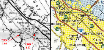 In1959,
Chapter 1062 added a new definition of LRN 214, as the route from LRN 239
(future I-280) near Woodside to LRN 68 (Bypass US 101; present-day freeway
US 101) at the Harbor Boulevard Interchange in Redwood City. This appears
to have been the designation for surface LRN 107 created in advance of the
freeway routing for LRN 107 (although until the freeway was constructed,
both were technically LRN 107). The route was Route 84 along Woodside
Road.
In1959,
Chapter 1062 added a new definition of LRN 214, as the route from LRN 239
(future I-280) near Woodside to LRN 68 (Bypass US 101; present-day freeway
US 101) at the Harbor Boulevard Interchange in Redwood City. This appears
to have been the designation for surface LRN 107 created in advance of the
freeway routing for LRN 107 (although until the freeway was constructed,
both were technically LRN 107). The route was Route 84 along Woodside
Road.
© 1996-2020 Daniel P. Faigin.
Maintained by: Daniel P. Faigin
<webmaster@cahighways.org>.
 Route 213
 Route 215