
 California Highways:
Click here for a key to the symbols used. An explanation of acronyms may be found at the bottom of the page.
 Routing
 Post 1964 Signage History
In 1963, this route was defined as “Route 82 near Mountain View to Route 17 near Milpitas.”
In 1965, Chapter 1371 extended the route from I-880 to I-680 by changing "Route 17" to "Route 680". This was done because there were once plans to build a Route 237 freeway angling northeast from about Zanker Rd, crossing I-880 near Dixon Landing Rd, and intersecting I-680 at Scott Creek Rd. There's a bridge at the latter interchange over "nothing", and with sharp eyes you can spot the "future rt. 237" marking on I-680 NB.
In 1988, Chapter 106 clarified the routing to be “Route 82 near
in Mountain View to Route 680 near in
Milpitas.”
 Pre 1964 Signage History
This was originally part of Route 9. It was LRN 113, defined in 1933. Before the current bridge over the Guadalupe River was constructed, it took a route into Alviso via Gold Street north and 1st Street southwest back to current Route 237.
 In 1954, a freeway routing for Sign Route 9 (Route 237) was proposed. The 6.8 mi freeway
would avoid the circuitous route through Alviso and cut 1.1 mi off the
driving distance. The plans call for initial construction of a two-lane
highway between the Bayshore and the Eastshore Freeways. The highway would
be raised sufficiently to avoid the periodic flooding the area was subject
to. The route follows the existing highway except for two miles between
Lawrence Station Road and the San Jose-Alviso Road. From the Lawrence
Station Road, the route runs almost straight easterly on a new alignment
through open country to San Jose-Alviso Road. It cuts across a southerly
loop and eliminates a triangular course in and out of Alviso then follows
the general line of the original highway from the San Jose-Alviso Road to
the Eastshore Freeway just W of Milpitas. Two curves near Coyote Creek and
Bowers Lane would be eliminated.
In 1954, a freeway routing for Sign Route 9 (Route 237) was proposed. The 6.8 mi freeway
would avoid the circuitous route through Alviso and cut 1.1 mi off the
driving distance. The plans call for initial construction of a two-lane
highway between the Bayshore and the Eastshore Freeways. The highway would
be raised sufficiently to avoid the periodic flooding the area was subject
to. The route follows the existing highway except for two miles between
Lawrence Station Road and the San Jose-Alviso Road. From the Lawrence
Station Road, the route runs almost straight easterly on a new alignment
through open country to San Jose-Alviso Road. It cuts across a southerly
loop and eliminates a triangular course in and out of Alviso then follows
the general line of the original highway from the San Jose-Alviso Road to
the Eastshore Freeway just W of Milpitas. Two curves near Coyote Creek and
Bowers Lane would be eliminated.
(Source: 1954 Newspaper Article via Joel Windmiller, 2/13/2023)
 Status
This is completely constructed to freeway standards from 1/2 mile from Route 82 (237 SCL 0.50) to I-880 (237 SCL R9.26); the last segment (from Middlefield Road to Maude Avenue) opened in 1997. There is currently construction work ongoing at the intersection with I-880.
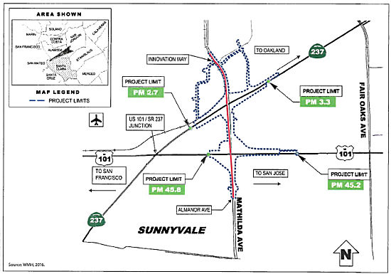
Matilda Monster (Route 237/US 101 Interchange, (04-SCl-237, PM 2.7/3.3, 04-SCl-101, PM 45.2/45.8))
 In August 2018, it was reported that the VTA will approve the final pieces of a funding package
in September 2018 to begin construction of a new $48 million interchange
for the Mathilda Monster at US 101 and Route 237. Work could begin by late
December 2018, and, if all goes well, be done by the end of 2019. This
includes widening Mathilda to three lanes, new stop lights and better
ramps. Design is complete, however there is a $17 million deficit with the
delay in Measure B funding. That half-cent sales tax is hung up in a
lawsuit.
In August 2018, it was reported that the VTA will approve the final pieces of a funding package
in September 2018 to begin construction of a new $48 million interchange
for the Mathilda Monster at US 101 and Route 237. Work could begin by late
December 2018, and, if all goes well, be done by the end of 2019. This
includes widening Mathilda to three lanes, new stop lights and better
ramps. Design is complete, however there is a $17 million deficit with the
delay in Measure B funding. That half-cent sales tax is hung up in a
lawsuit.
(Source: Mercury News, 8/14/2018)
In August 2018, the CTC approved for future
consideration of funding the following project for which a Final
Environmental Impact Report (FEIR) has been completed: Route 237 and US 101 in Santa Clara County (04-SCl-237, PM 2.7/3.3, 04-SCl-101, PM
45.2/45.8). Construct roadway improvements on a portion of Route 237 and
US 101 in the city of Sunnyvale. (PPNO 0462H) This project proposes to
improve Mathilda Avenue in the city of Sunnyvale in Santa Clara County,
from the Almanor Avenue/Ahwanee Avenue Interchange to Innovation Way. The
project proposes to improve the on and off ramps at the Route 237/Mathilda
Avenue and US 101/Mathilda Avenue Interchanges. Also proposed in the
project are new retaining walls, reconstruction of sound walls,
signalization of intersections, new left-turn lanes, modifications to
bicycle and pedestrian facilities, storm water treatment facilities,
street lighting, ramp metering, signage and light rail crossing
facilities. The proposed project is estimated to cost in total
approximately $42 million. Funding sources are anticipated to be from
various local funds. The project is estimated to begin construction in
2018. Additionally, the August CTC meeting approved an allocation of
$17,000,000 for the locally-administered Senate Bill 1 (SB 1) Local
Partnership Program (LPP) (Competitive) Mathilda Avenue Improvements at
Route 237 and US 101 project (PPNO 0462H), in Santa Clara County.
(Source: August 2018 CTC Agenda Item 2.2c.(11),
Agenda Item 2.5s.(2))
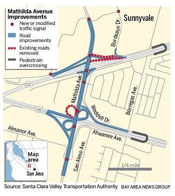 In August 2019, it was reported that Moffett Park Drive between Mathilda and Bordeaux was
closing permanently in preparation for the realigning of the westbound
Route 237 off-ramp onto Mathilda. Motorists, cyclists, and pedestrians
will still be able to travel along Moffett Park east of Bordeaux and west
of Mathilda. As an alternative to using Moffett to exit, motorists were
directed to Innovation Way, which has been signalized to better
accommodate higher traffic volumes. Work on the westbound Route 237
off-ramp onto Mathilda will commence with the closure of Moffett Park
Drive. The realignment of the off-ramp eliminates the short spacing of
signals along Mathilda just north of the Route 237 overcrossing and will
help improve traffic flow by easing backups and lessening delays.
Completion of the ramp realignment is expected in Fall 2019. Construction
on the entire project is expected to be complete in Summer 2020.
In August 2019, it was reported that Moffett Park Drive between Mathilda and Bordeaux was
closing permanently in preparation for the realigning of the westbound
Route 237 off-ramp onto Mathilda. Motorists, cyclists, and pedestrians
will still be able to travel along Moffett Park east of Bordeaux and west
of Mathilda. As an alternative to using Moffett to exit, motorists were
directed to Innovation Way, which has been signalized to better
accommodate higher traffic volumes. Work on the westbound Route 237
off-ramp onto Mathilda will commence with the closure of Moffett Park
Drive. The realignment of the off-ramp eliminates the short spacing of
signals along Mathilda just north of the Route 237 overcrossing and will
help improve traffic flow by easing backups and lessening delays.
Completion of the ramp realignment is expected in Fall 2019. Construction
on the entire project is expected to be complete in Summer 2020.
(Source: Mercury News $$$, 8/1/2019)
In October 2023, the CTC authorized relinquishment of
right of way (04-SCl-237-PM 2.8/3.0; 2 segments) consisting of collateral
facilities to the City of Sunnyvale (City) along Route 237 on and along
West Moffett Park Drive, under the terms and conditions as stated in the
freeway agreement dated December 4, 2018. The City, by letter dated
June 9, 2023, agreed to waive the 90-day notice requirement and accept
title upon relinquishment by the State.
(Source: October 2023 CTC Agenda, Agenda Item 2.3c)
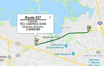
Route 237 HOV/HOT Lanes (~ SCL 3.047 to SCL 8.036)
 In January 2012, it was reported there are plans to
convert the HOV lanes on Route 237 to HOT (Toll) Lanes. This change means
the lanes will have fixed entry and exit points. They will remain free to
carpoolers, those on motorcycles, and those with exemption stickers; other
drivers can use Fasttrak transponders. The conversion will take place on
2/27/2012, and costs $11.8 million. The toll is anticipated to range
between 30¢ and $3.00. These lanes opened at the end of March 2012.
In January 2012, it was reported there are plans to
convert the HOV lanes on Route 237 to HOT (Toll) Lanes. This change means
the lanes will have fixed entry and exit points. They will remain free to
carpoolers, those on motorcycles, and those with exemption stickers; other
drivers can use Fasttrak transponders. The conversion will take place on
2/27/2012, and costs $11.8 million. The toll is anticipated to range
between 30¢ and $3.00. These lanes opened at the end of March 2012.
In March 2015, it was reported that the Valley
Transportation Authority (VTA) was finalizing its plan to add HOT lanes on
Route 237 from Mathilda Avenue in Sunnyvale (237 SCL 3.047) to North First
Street (237 SCL 6.898) in San Jose. Phase 2 of the plan, which is set to
be completed in late 2016, deals particularly with the extension of
express lanes on Route 237, but it is part of a bigger project called
Silicon Valley Express Lanes Program that deals with express lane
extensions on US-101, Route 85 and Route 237. These lanes are extensions
of the current express lanes that run from I-880 north and south from
Milpitas to Route 237, and along Route 237 from I-880 interchange to
Lawrence Expressway heading west and beginning at North First Street going
east. Total project cost is $21 million. About 36% of funding for Phase 2
will come from tax revenues, and the other 64% comes largely from federal
grants. Phase 3 of the project will span multiple corridors and will
entail adding direct connectors and "flyovers" for Route 85 and US-101 in
South San Jose and Route 85 and US-101 in Mountain View. The entire
Silicon Valley Express Lanes Program is set to be completed in 2035.
(Source: San Jose Mercury-News, 3/13/2015)
In June 2015, it was reported that Caltrans and the
Valley Transportation Authority were changing the striping into the
express lane on WB Route 237 between North First Street (apx 237 SCL
6.898) and Zanker Road (apx 237 SCL 8.036). About 4,100 feet of double
solid white stripes will be replaced by dashed striping, which indicates
new entry and exit points and allows carpoolers earlier access into the
express lane. And it will allow commuters to exit the express lane at the
North First offramp, which has been prohibited by the double solid white
stripe. The Route 237 express lane ends near Lawrence Expressway. This
design will be evaluated for 6 months before it will be made permanent.
(Source: San Jose Mercury News, 6/23/2015)
In August 2017, it was reported that Caltrans plans to
extend the metering lights westbound during the morning commute from 10
a.m. until 11 a.m, perhaps by the end of 2017. In 2018, work to extend the
carpool/express lanes on Route 237 to US 101 and I-880 could begin.
(Source: Mercury News, 8/16/2017)
In September 2018, it was reported that the VTA has
begun the next phase of work to convert the carpool lanes on Route 237
into Express Lanes from Zanker Road in San Jose to Mathilda Avenue in
Sunnyvale. As on I-580 in the Livermore Valley and I-680 in Contra Costa
County, hours will run from 5 a.m. to 8 p.m. and most drivers will need
FasTrak. These will likely be the rules on I-880 from Oakland to Milpitas,
and on US 101 from Route 85 in Mountain View to I-380 on the Peninsula.
Those with three or more people in a vehicle will ride free of charge.
Those carrying just two people may also have to pay but will likely get a
50 percent discount off the toll. The express lanes will take a year to
complete.
(Source: Mercury News, 9/26/2018)
In November 2019, it was reported that the second phase
of the Silicon Valley Express Lanes on Route 237 was rolling out, when
carpool lanes convert to express lanes, but the new rules may leave some
commuters baffled. Express lanes, which will be extended west on Route 237
to Mathilda Avenue in Sunnyvale, are the most significant change governing
Bay Area roadways in almost 50 years when carpool lanes and metering
lights first sprouted. The first phase of Route 237 express lanes opened
in 2012 near Dixon Landing Road and include the I-880/Route 237 connector.
With the new lanes, all express lanes users must have a FasTrak
transponder, and the lanes will run from 5 a.m. to 8 p.m. weekdays.
Electric car owners will no longer ride free in a carpool lane. They will
also pay a toll to use the express lane but will get a 50 percent
discount. The CHP will use cameras to catch cheaters with fines going to
the VTA instead of the state. Drivers will be able to merge into the toll
lanes at almost all locations on Route 237, rather than only at specific
entrance and access points, which is the case on I-680 express lanes in
the Fremont area.
(Source: Mercury News, 11/14/2019)
[CTC February 2002 Agenda Item 2.3c]. The following segments of the original routing may have been relinquished: PM R5.6 to PM R5.8 in the City of San Jose.
San Jose Aux Lanes (04-SCl-237 7.0/8.0)
In October 2017, the CTC added the following project into the SHOPP: 04-SCl-237 7.0/8.0: On Route 237 in Santa Clara County: In San Jose, in the westbound direction from Zanker Road to North First Street. Construct auxiliary lane.
The following project was included in the final adopted 2018 SHOPP in March 2018: PPNO 1492A. 04-Santa Clara-237 7.0/8.0. Route 237 In San Jose, in the eastbound direction from North First Street to Zanker Road. Construct auxiliary lane. Begin Con: 6/15/2022. Total Project Cost: $15,175K.
The following project was included in the final adopted 2018 SHOPP in March 2018: PPNO 1492A. 04-Santa Clara-237 7.0/8.0. Route 237 In San Jose, in the eastbound direction from North First Street to Zanker Road. Construct auxiliary lane. Begin Con: 2/1/2023. Total Project Cost: $79,073K.K.
The 2020 SHOPP, approved in May 2020, included the
following Mobility item of interest (carried over from the 2018 SHOPP):
04-Santa Clara-237 PM 7.0/8.0 PPNO 1492A (1492B) Proj ID 0416000060
(0416000061) EA 0K240 (0K250). Route 237 in San Jose, in the eastbound
(westbound) direction from North First Street to Zanker Road. Construct
auxiliary lane. Programmed in FY21-22, with construction scheduled to
start in February 2023. Total project cost is $15,175K ($79,073K), with
$8,285K ($71,642K) being capital (const and right of way) and $6,890K
($7,431K) being support (engineering, environmental, etc.).
(Source: 2020 Approved SHOPP a/o May 2020)
In October 2020, the CTC approved the following SHOPP
Support Phase allocation: $2,080,000 for PS&E and $130,000 for R/W Sup
for 04-SCl-237 PM 7.0/8.0. PPNO 04-1492A ProjID 0416000060 EA 0K240. Route 237 in San Jose, in the eastbound direction from North First Street to
Zanker Road. Construct auxiliary lane.
(Source: October 2020 CTC Agenda, Agenda Item
2.5b.(2a) #17)
In June 2021, the CTC amended the SHOPP to delete this
project: 04-SCl-237 7.0/8.0 PPNO 1492B; ProjID 0416000061 EA
04-0K250. In San Jose, in the westbound direction from Zanker Road to
North First Street. Construct auxiliary lane. Note: Delete
project. Additional traffic studies concluded that the project build
alternative will not achieve the intended benefit. Total
$79,073K.
(Source: June 2021 CTC Agenda, Agenda Item
2.1a.(2d) #20)
In May 2022, the CTC approved the following
construction phase allocation: $7,826,000. 04-SCl-237 7.0/8.0. PPNO
04-1492A; ProjID 0416000060; EA 0K240. Route 237 In San Jose, in the
eastbound direction from North First Street to Zanker Road.
Outcome/Output: Construct auxiliary lane to reduce congestion, and improve
highway operations and mobility. Programmed Allocation: CON ENG:
$1,560,000; CONST $8,030,000.
(Source: May 2022 CTC Agenda, Agenda Item 2.5b.(1)
#5)
In November 2006 and February 2008, the CTC considered relinquishment of segments in San Jose, consisting of reconstructed and relocated city streets. The February 2008 relinquishement was near Zanker Road. (apx 237 SCL 8.036))
At one time, there were plans to build this a freeway from I-880 to I-680 (~ SCL 9.494 to SCL 11.012). However, this now seems unlikely, and a study is being conducted in 2002 to explore upgrading Route 262 instead. According to a posting by Joe Rouse on m.t.r, the planned freeway alignment tied in with the existing alignment west of I-880, crossing I-880 at Dixon Landing Road, and ending at I-680 just south of Scott Creek Road. There are two bridges on I-680 just south of Scott Creek where the ramps would have passed underneath that might have been part of the plan. The problem with this hypothetical routing (it is unclear if it ever went beyond the "on paper" level) was that it would go through a big chunk of the South Bay National Wildlife Refuge. Daniel T. reported on m.t.r that the 1967 and 1969 Gousha maps of San Jose both show the proposed routing, and this routing matches the 1967 Regal Map of San Jose, which actually shows interchange designs. According to the map routings, the I-680 to I-880 connector left the current Route 237 alignment just east of Lafayette Street. It then went NE to Zanker Road, with a standard diamond interchange. It then turned NNE, having a modified cloverleaf interchange with the Nimitz Freeway (EB 237/NB Nimitz and WB 237/SB Nimitz were to be flyovers). Dixon Landing would have been rerouted to loop around the southern end of this interchange. Route 237 would then cross the Alameda/Santa Clara County line, have a half interchange at Oakland Road (straight ramps for EB 237/SB Oakland, loop ramps for NB Oakland/WB 237). The last interchange, 237/680, would be a trumpet, with EB 237/NB 680 flying over and NB 680/WB 237 flying under (at Scott Creek Road, hence the Caltrans Bridge Log entry).
In December 2016, it was reported that long-range plans call for
converting Calavaras Blvd (Route 237, 237 SCL 9.504) in Milpitas to six
lanes. In 2009 the city adopted a traffic impact fee on all new
developments to help fund the widening of Calaveras over the UPRR tracks.
But there is still a huge funding gap, and nothing is imminent. Fomer
Milpitas Mayor Bob Livengood said in 1993 that “unless something
really strange happens, what Calaveras looks like today is what Calaveras
will look like for many years to come.”
(Source: Mercury News, 12/8/2016)
 Commuter Lanes
In Santa Clara County, there is a westbound HOV lane from the I-880/Route 237 junction to E of Mathilda Avenue, for a length of 6 mi. Eastbound, there is a HOV lane from Mathilda Avenue to 1.1 mi W of I-880, for a length of 5.7 mi. The westbound lane was opened in 1984, extended in 1991, and relocated in 1995. The eastbound lane was opened in 1984, extended in 1991, relocated in 1995, and shortened in 1996. These require two or more occupants, and are in operation weekdays during the following hours: 5:00-9:00pm and 3:00-7:00pm.
There are plans to connect direct HOV connectors between Route 237 and Tasman Drive. July 2002 CTC Agenda.
 Naming
 Named Structures
Bridge 37-0470, the South Alviso Overhead bridge in the City of San Jose (SCL R006.10), is officially designated the "Warren West Memorial Bridge". It was built in 1993, and was named by Assembly Concurrent Resolution No. 59, Chapter 105, in the same year. Warren West was driving piles to support the South Alviso Overhead when he suffered a fatal heart attack on January 22, 1993.
 Exit Information
 National Trails
 This route is part of the De Anza National Historic Trail.
 Other WWW Links
 Classified Landcaped Freeway
The following segments are designated as Classified Landscaped Freeway:
| County | Route | Starting PM | Ending PM |
| Santa Clara | 237 | R0.38 | R1.01 |
| Santa Clara | 237 | 1.05 | 2.05 |
| Santa Clara | 237 | 3.22 | R3.75 |
| Santa Clara | 237 | R3.98 | R4.55 |
| Santa Clara | 237 | 5.40 | 6.05 |
| Santa Clara | 237 | 6.46 | 7.12 |
| Santa Clara | 237 | 7.81 | 8.17 |
 Freeway
[SHC 253.1] Entire route. Added to the Freeway and Expressway system in 1959.
 Statistics
Overall statistics for Route 237:
 Pre-1964 Legislative Route
In 1956 (ex. sess.), Chapter 63 defined LRN 237 as “Junipero Serra Boulevard as it exists and as it was constructed by Joint Highway District No. 10 from its junction with [LRN 56] in Daly City to the present terminus of said highway in the City of San Bruno. Upon the effective date of this section, the Joint Highway District No. 10 shall be dissolved in accordance with the provisions of Chapter 20 of Part 1 of Division 16 of the Streets and Highway Code and all property, assets, and liabilities of said district shall become the property of the State.”
This is a close approximation of the current route of I-280, but was really the original 1964 routing of Route 117. The Route 117 designation may be predated the I-280 designation.
© 1996-2020 Daniel P. Faigin.
Maintained by: Daniel P. Faigin
<webmaster@cahighways.org>.
 From Route
  Route 236
 Route 238