
 California Highways:
Click here for a key to the symbols used. An explanation of acronyms may be found at the bottom of the page.
 Routing
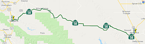 (a) From Route 101 near Santa Margarita to Route 33.
 Post 1964 Signage History
This segment remains as defined in 1963.
 Pre 1964 Signage History
This segment was LRN 58, but was signed as Route 178 until 1964. The renumbering occurred as part of the renumber of former US 466 as Route 58. This segment was defined in 1933, signed in 1934.
Tom Fearer (Max Rockatansky) noted on AARoads:
(Source: Tom Fearer on AARoads, "Bitterwater Road, Old SSR 178, more LRN 137, and the 1914 Salinas River Bridge", 2/8/2017)
From 1934 to 1956, Route 178 would have used Pozo Road to cross the La Panza Range to reach Santa Margarita and US 101. A look at even Google Maps shows why Route 178 was realigned, it wasn't a very good route that had a hugely twisty alignment. The modern route is largely something you can hold a decent 45-55 MPH in most curves much like Route 198 over the Diablos. When Route 178 was plotted out in 1934 it went through a town called La Panza (named after the range) and the village of Pozo which is located near Santa Margarita Lake. Pozo still exists as an inhabited place while La Panza is now a ghost town. Splitting off of Route 58 on Pozo Road there was oddly a Calfire Station despite the poor road quality. On the old California state maps, LRN 137 runs from Route 178 just outside of Santa Margarita over the Salinas River up to Creston. In 1956, Route 178/LRN 58 was realigned along what was LRN 137 to the modern southern terminus of Route 229 east along modern Route 58. US 101 was also shifted west to the modern bypass which meant Route 178/LRN 58 was extended through Santa Margarita.
 Status
Trout Creek Bridge (05-SLO-58 3.1)
In December 2017, the CTC approved for future consideration of funding a project, located near the town of Santa Margarita in San Louis Obispo County, that proposes to replace the Trout Creek Bridge on Route 58 (05-SLO-58, PM 3.08). The proposed project will construct a two lane bridge with bicycle lanes in each direction. The project is funded and programmed in the 2016 SHOPP with an estimated total of $8.9 million, which includes Construction (capital and support) and Right-of-Way (capital and support). Construction is estimated to begin in Fiscal Year 2019-20. The scope, as described for the preferred alternative, is consistent with the project scope programmed by the Commission in the 2016 SHOPP.
The following project was included in the final adopted 2018 SHOPP in March 2018: PPNO 0072B. 05-SLO-58 3.1. Route 58 Near
Santa Margarita, at Trout Creek Bridge No. 05-49-0091. Replace
bridge. Begin Con: 8/12/2020. Total Project Cost: $13,324K.
In May 2019, the CTC approved the following SHOPP
Amendment 05-SLO-58 3.1 PPNO 0072B ProjID 0515000099. Route 58 Near Santa
Margarita, at Trout Creek Bridge No. 05-49-0091. Replace
bridge. Increase const cap to $7,573K; total to $14,910K. Note: Increase
in construction capital is due to increase in abutment pile quantity and
rock slope protection, volatility in precast pricing, and change in
traffic handling and barrier rail type.
(Source: May 2019 CTC Agenda Item 2.1c.(1) Amend
Item 51)
In March 2020, the CTC approved the following financial
allocation: 05-SLO-58 PM 3.1. PPNO 0072B. ProjID 0515000099. EA 0L723. On
Route 58 near Santa Margarita, at Trout Creek Bridge No. 49-0091. Outcome/Output:
Replace bridge, widen shoulders and install bridge rail to current
standards. Financial allocation: $9,848,000.
(Source: March 2020 CTC Agenda, Agenda Item
2.5b.(1) #19)
 (b) From Route 33 to Route 43.
Post 1964 Signage HistoryThis segment remains as defined in 1963.
In July 2022, it was reported that Route 58 signage was observed on
Stockdale Highway at the interchange with I-5.
(Source: Andy Field (andy3175) on AARoads, 7/10/2022)
Pre 1964 Signage HistoryThis segment was LRN 58, but was signed as Route 178 until 1964. The renumbering occurred as part of the renumber of former US 466 as Route 58. This segment was LRN 58, but was signed as Route 178 until 1964. It was also defined in 1933, signed in 1934.
Status![[Buttonwillow]](maps/058-buttonwillow.jpg) In April 2010, the CTC approved for future
consideration of funding a project in Kern County that will rehabilitate a
6.5 mi portion of Route 58 with new asphalt paving over existing concrete
near Buttonwillow (~ KER 27.542). The project is fully funded in the 2008
State Highway Operation and Protection Program. Total estimated project cost
is $3,005,000 for capital and support. Construction is estimated to begin in
Fiscal Year 2010-11. The project had a mitigated negative environmental
declaration (MND). The project will involve construction activities
resulting in impacts to the habitat of Federally listed threatened and
endangered species including the Tipton kangaroo rat, the San Joaquin
antelope squirrel, and the San Joaquin kit fox.
In April 2010, the CTC approved for future
consideration of funding a project in Kern County that will rehabilitate a
6.5 mi portion of Route 58 with new asphalt paving over existing concrete
near Buttonwillow (~ KER 27.542). The project is fully funded in the 2008
State Highway Operation and Protection Program. Total estimated project cost
is $3,005,000 for capital and support. Construction is estimated to begin in
Fiscal Year 2010-11. The project had a mitigated negative environmental
declaration (MND). The project will involve construction activities
resulting in impacts to the habitat of Federally listed threatened and
endangered species including the Tipton kangaroo rat, the San Joaquin
antelope squirrel, and the San Joaquin kit fox.
 Naming
 Freeway
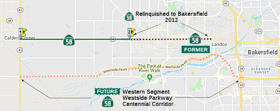 (3) From Route 43 to just west of Van Buren Place near
Bakersfield.
(3) From Route 43 to just west of Van Buren Place near
Bakersfield.
Upon a determination by the commission that it is in the best interests of the state to do so, the commission may, upon terms and conditions approved by it, relinquish to the City of Bakersfield or the County of Kern the portion of Route 58 that is located within the city limits of that city if the city or county agrees to accept it. The following conditions shall apply upon relinquishment: (1) The relinquishment shall become effective on the date following the county recorder's recordation of the relinquishment resolution containing the commission's approval of the terms and conditions of the relinquishment. (2) On and after the effective date of the relinquishment, the relinquished portion of Route 58 shall cease to be a state highway. (3) The portion of Route 58 relinquished under this subdivision shall be ineligible for future adoption under Section 81. (4) For the portion of Route 58 that is relinquished under this subdivision, the City of Bakersfield or the County of Kern shall install and maintain within the jurisdiction of the city signs directing motorists to the continuation of Route 58. Added by AB 1858, Chapter 315, September 18, 2006.
In March 2012, the CTC authorized relinquishment of right of way in the county of Kern on Route 58 from the Bakersfield city limits west of Allen Road (approx KER 45.943) to Mohawk Street (approx KER 50.642), from Verdugo Lane to the Bakersfield city limits west of Patton Way, under terms and conditions as stated in the relinquishment agreement dated February 14, 2012, determined to be in the best interest of the State. Authorized by Chapter 491, Statutes of 2010, which amended Section 358 of the Streets and Highways Code.
Post 1964 Signage HistoryThis segment remains as defined in 1963.
During 1973 the Kern Council of Governments (Kern COG) identified a need
for a "Westside Freeway" to replace Rosedale Highway as the alignment of
Route 58 in their 1990 Transportation Plan & Program. The Route 99 (former US 99) / Route 58 interchange in Bakersfield was completed in
1976. Route 58 was relocated east of Route 99 onto a new freeway
grade (Rosa Parks Highway). North from the new interchange, Route 58
was multiplexed on northbound Route 99 to Rosedale Highway. From
Route 99, the routing of Route 58 continued west to I-5 along Rosedale
Highway.
(Source: Gribblenation Blog (Tom Fearer), "Westside Parkway and the Centennial Corridor; Future California_State_Route 58", 2/2024)
The existing alignment of Route 58 in western Bakersfield persisted with
minimal improvements despite being part of the Freeways & Expressway
System. Feasibility studies on transferring Route 58 to the proposed
Westside Freeway began in 1992 with a Tier 1 Environmental Impact
Statement (EIS). Caltrans and the Federal Highway Administration
approved an EIS which had evaluated two proposed alternatives for the
proposed Westside Freeway.
(Source: Gribblenation Blog (Tom Fearer), "Westside Parkway and the Centennial Corridor; Future California_State_Route 58", 2/2024)
▸In 2006, AB 1858, Chapter 315, September 18, 2006 permitted relinquishment of the portion of this route in Bakersfield. This segment was relinquished in March 2012. Note that this relinquishment did not preclude a subsequent adoption of a different routing between the same points.
▸In 2013, Chapter 525 (SB 788, 10/9/2013) split this into two segments:
The California Transportation Commission, which is responsible for handling the adoption and relinquishment of State highways, approved the adoption of Stockdale Highway from I-5 to the western end of the Westside Parkway and the majority of the Westside Parkway (from its western end up to Coffee) as Route 58 in late 2020. The city of Bakersfield subsequently transferred this portion of the Westside Parkway to Caltrans on February 5, 2021. Noting from the status below:(3) From Route 43 to just west of Van Buren Place near Bakersfield.
(4) Mohawk Street near Bakersfield to Route 99.
In December 2020, the CTC approved the recommendation
of route adoption for Route 58 as a new freeway alignment from 0.3 miles
east of Heath Road to Coffee Road as part of the Route 58 corridor
improvements. The Commission approved the Resolution for Future
Consideration of Funding for the Final Environmental Impact Report (EIR)
via Resolution E-18-30 during the March 2018 Commission meeting, and the
Department signed a revalidation form on June 1, 2020. The Department
approved the Route Transfer Report on October 15, 2020. In
1973, the Kern Council of Governments (Kern COG) prepared the 1990
Transportation Plan and Program and the County prepared the Rosedale
General Plan, each identifying the “Westside Freeway,” now
known as WSP, as a major circulation element. Studies for this transfer of
highway location on the Route 58 corridor began in 1992 with a Tier 1 EIR/
Environmental Impact Statement (EIS). In 2001, the Department, as the
California Environmental Quality Act (CEQA) lead agency, and the FHWA, as
the National Environmental Policy Act (NEPA) lead agency, approved the
environmental document that evaluated two alignment alternatives for the
corridor.
Construction of WSP, which was intended to be a State highway, began in
2008 and was completed in April 2015. Due to work proposed on Route 99,
the Department approved the City’s Project Report and Final EIR/EIS
for the Centennial Corridor Project on December 4, 2015. That
environmental document cleared the route to be transferred into the SHS
and this freeway adoption. In 2016, the Department began evaluating WSP to
determine the feasibility of the route transfer. As a result, certain
areas of WSP were found to need remediation before transfer into the SHS.
Between 2017 and 2020, the City completed the required remediation work to
the Department's satisfaction. The proposed Route 58 freeway alignment
along WSP is a 6-mile-long, 4 to 6-lane freeway with 12-foot lane widths
and 10-foot shoulder widths, and is located approximately 1-2 miles south
of the current Route 58.
(Source: October 2020 CTC Agenda, Agenda Item
2.3a.(2))
As part of the Transfer, once the route adoption is
approved, the Department will concurrently relinquish the superseded Route 58 to the City and County, within their respective jurisdictions.
The Department and the City and County have executed relinquishment
agreements for Route 58 within the Transfer limits. On October 1,
2020, the Department approved a $12,100,000 pavement rehabilitation and
Americans with Disability Act (ADA) facility upgrade project along Route 58, from Route 43 to 0.1 mile west of Allen Road, within the Transfer
limits. To date, the Department has expended $1,400,000 of the
programmed funds. In lieu of completing the project, the Department
agreed to pay the County the remaining project budget of $10,650,000 as
the cost of relinquishment and is the only cost to the Department
associated with the Transfer. This was covered in the SHOPP amendment
above.
(Source: October 2020 CTC Agenda, Agenda Item
2.3a.(1))
There are several concurrent actions associated with
this transfer that were presented to the Commission on the December 2020
agenda for approval. There was the route adoption, the Freeway Route Adoption, the relinquishment of three segments of the current Route 58 to
the City and County within their respective jurisdictions, an action item
under Reference 2.3c.(2), and the funds transfer from the Department to
the County, an action item under Reference 2.5b.(4). All of these
associated actions must be approved by the Commission for the Transfer to
be approved. If any of the concurrent actions presented above are
not approved, then the Transfer as a whole is not approved, and all prior
associated approvals are nullified. The approval of both route adoption
book items will allow for the execution of Freeway Agreements with the
City and County.
(Source: October 2020 CTC Agenda, Agenda Item
2.3a.(1))
Note: The 2013 changing of the definition means that the segment of the Centennial Corridor within Bakersfield may not be state highway; legislative changes would be required to add it back to the state system.
Pre 1964 Signage HistoryThis segment was LRN 58, but was signed as Route 178 until 1964. The renumbering occurred as part of the renumber of former US 466 as Route 58. This segment was also defined in 1933, signed in 1934.
The pre-2020 routing of Route 58 was added to the SHS on September 5, 1933 by an approved County Board of Supervisors' resolution as part of the Breed Act; therefore, this routing has never been officially adopted by the Commission. A new routing was submitted for adoption at the end of 2020: See the discussions on the Western Segment, Westside Parkway, and Centennial Corridor below.
StatusThe SAFETEA-LU act, enacted in August 2005 as the reauthorization of TEA-21, provided the following expenditures on or near this route:
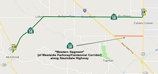
Western Segment (Heath Road to I-5: ~ KER 31.879 to ~ KER 44.038)
In October 2008, the CTC received a notice of preparation of an EIR regarding these routes. The study will evaluate a range of alternative route alignments for Route 58 as a limited access facility from its current terminus at Route 99 to Route 5. Upon completion of the Environmental Impact Report (EIR), a proposed route adoption will be presented to the Commission. The EIR will be divided into three segments:
The entire corridor is not fully funded. Funding for the Eastern Connection has been identified in the Regional Transportation Plan, but the project is currently not programmed. Estimated total cost of this segment is $650 million, with construction estimated to begin in Fiscal Year 2015. Phase 1, 2, 3, and 4 of the Westside Parkway project are fully funded in the 2008 State Transportation Improvement Program. Estimated cost, capital and support, is $234 million. Phases 5 and 6 are currently not programmed. The Western Segment is currently not programmed. The Westside Parkway and Western Segment portions have been previously addressed in CEQA and NEPA environmental documents; however, the Eastern Connection remains to be evaluated. This EIR will incorporate by reference the previously analyzed segments to revalidate these segments and evaluate current conditions and impacts of the Eastern Connection segment. This EIR and the subsequent route adoption would incorporate the Westside Parkway into the State Highway System after environmental evaluation of impacts to air, noise and traffic volumes. The Westside Parkway will begin construction in phases in FY 2008-09 utilizing the previous EIR. The Western Segment does not have an estimated start construction date.
 There are six alternatives being considered:
In November 2012, it was reported that Caltrans had selected Alternative B.
In May 2014, it was reported that Alternative B was
still the preferred and least expensive option. The EIR, released 15
months late, found Alternative B would improve traffic throughout
metropolitan Bakersfield -- but as currently planned would require the
demolition of 200 single-family homes, 110 multiple-family structures and
121 commercial buildings. Previously, the freeway alternative through
southwest Bakersfield was thought to require the demolition of more than
199 single-family homes, 16 multiple-family structures and 36 businesses.
Currently, Caltrans also estimates Alternative B would require 293 full
parcel acquisitions, 129 partial parcel acquisitions -- and could displace
an estimated 961 people. However, many of the full parcial acquisitions
could only end up needing only "sliver takes". The project right now is in
public hearing mode. A decision is expected by year's end, and if the
project is approved construction could begin by mid-2016. According to the
EIR, Alternative B's recommended path would have "adverse effects to the
character of ... southwest Bakersfield and (the) Westpark neighborhood,"
which it would bisect. It also would raise noise levels above the
generally acceptable 62-70 decibel range in 484 outdoor areas, which can
be mitigated with soundwalls and landscaping. Caltrans has considered
Alternatives A and C to be unfeasible since December 2012. Alternative A,
a connector southwest of Alternative B, would affect Rancho Vista Historic
District. Alternative C, a connector slightly to the northeast of B, would
impact Saunders Park. Both the park and the historic district are
protected under Federal Highway Administration guidelines. Alternative A
would demolish the most structures, and at $691 million in right-of-way
and construction costs is the most expensive. Alternative C has the fewest
demolitions, but at $665.5 million for right-of-way and construction is
the second most expensive proposal.
(Source: Bakersfield Californian, 5/9/2014)
In June 2014, the CTC received the draft EIR for review. The EIR noted the environmental impacts as well as the public controversy. It proposed the following mitigations for the route:
In March 2018, the CTC approved for future
consideration of funding a project that proposes to construct a new
freeway alignment for Route 58 in order to link Route 58 with Interstate 5
(I-5). The project also includes route improvements along Route 58 from
I-5 (~ KER 31.879) to Cottonwood Road (~ KER R55.432), and to Route 99
from Wilson Road to Gilmore Avenue. The estimated total overall cost of
the project is $629.0 million. The project is not totally funded and
currently programmed in the 2016 State Transportation Improvement Program
(STIP) for an estimated total $33.0 million for Construction capital, $19
million in federal earmarked funds and $62 million in local Transportation
Development Fund sources. The project is estimated to begin in Fiscal Year
2018-19. The scope, as described for the preferred alternative, is
consistent with the project scope programmed by the Commission in the 2016
STIP.
(Source: CTC Agenda, March 2018 Agenda Item 2.2c(10))
In December 2020, the CTC amended the 2020 SHOPP to
revise the following project as indicated: 06-Ker-58 PM 39.9/46.0. PPNO
06-6756 ProjID 0615000212 EA 0U110. Route 58 In and near Bakersfield, from
Route 43 to 0.1 mile west of Allen Road. Pavement
rehabilitation. Financial Contribution Only (FCO) to Kern
County for pavement rehabilitation to relinquish by relocating a portion
of the route. The change zeroes the previous programming for
PS&E ($1,200K) R/W Sup ($250K) and Con Sup ($1,900K).
It increases Const Cap ($7,000K $10,650K). This
increases the total for the project by $300K. (Concurrent CONST allocation
under Resolution FP-20-41; December 2020.) (Concurrent
relinquishment agreements under Resolutions R-4056 and R-4057; December
2020.) Note: Accelerate project to accommodate relinquishment.
This portion of the route is being relocated to a new alignment previously
constructed by local agencies. This project is a Financial
Contribution Only (FCO) to allow Kern County to bring pavement to good
repair after relinquishment.
(Source: December 2020 CTC Agenda, Agenda Item
2.1a.(1d) #10)
 Also, in December 2020, the CTC approved a Caltrans
request for a route adoption and transfer of highway location of Route 58
as a State highway to a new alignment from I-5 to Coffee Road in Kern
County. This is part of the Route 58 corridor improvements. The purpose of
the transfer of highway location is to establish a new alignment for a
portion of Route 58 in Kern County. The City of Bakersfield (City),
Kern County (County), and the Department are jointly proposing the route
adoption of segments of the local roads known as Stockdale Highway and the
Westside Parkway (WSP) into the State Highway System (SHS) as the new
Route 58 alignment. The proposed Transfer consists of the adoption
of a new parallel route approximately 2-3 miles south of the existing
Route 58 alignment along the Stockdale Highway segment from I-5 to Heath
Road and the WSP segment from Heath Road to the Coffee Road interchange,
as well as the relinquishment of the superseded segments of Route 58 to
the City and County within their respective jurisdictions, as shown on the
attached vicinity map. In December 2011, the City, County, and the
Department agreed to transfer Stockdale Highway, WSP, and the Centennial
Corridor into the SHS in phases to ultimately form a continuous Route 58
alignment from I-5 to Route 99 and to relinquish the current Route 58 to
the City or County. The Centennial Corridor is the final segment of
the proposed Route 58 corridor from I-5 to Route 99, linking WSP from
Truxtun Avenue to Route 99 on a new freeway alignment, and is currently
under construction with an anticipated completion by the 2022-2023
timeframe.
Also, in December 2020, the CTC approved a Caltrans
request for a route adoption and transfer of highway location of Route 58
as a State highway to a new alignment from I-5 to Coffee Road in Kern
County. This is part of the Route 58 corridor improvements. The purpose of
the transfer of highway location is to establish a new alignment for a
portion of Route 58 in Kern County. The City of Bakersfield (City),
Kern County (County), and the Department are jointly proposing the route
adoption of segments of the local roads known as Stockdale Highway and the
Westside Parkway (WSP) into the State Highway System (SHS) as the new
Route 58 alignment. The proposed Transfer consists of the adoption
of a new parallel route approximately 2-3 miles south of the existing
Route 58 alignment along the Stockdale Highway segment from I-5 to Heath
Road and the WSP segment from Heath Road to the Coffee Road interchange,
as well as the relinquishment of the superseded segments of Route 58 to
the City and County within their respective jurisdictions, as shown on the
attached vicinity map. In December 2011, the City, County, and the
Department agreed to transfer Stockdale Highway, WSP, and the Centennial
Corridor into the SHS in phases to ultimately form a continuous Route 58
alignment from I-5 to Route 99 and to relinquish the current Route 58 to
the City or County. The Centennial Corridor is the final segment of
the proposed Route 58 corridor from I-5 to Route 99, linking WSP from
Truxtun Avenue to Route 99 on a new freeway alignment, and is currently
under construction with an anticipated completion by the 2022-2023
timeframe.
(Source: October 2020 CTC Agenda, Agenda Item
2.3a.(1))
The construction of WSP was completed in April
2015. Due to work proposed on Route 99, the Department approved the
City’s Project Report and Final EIR/EIS for the Centennial Corridor
Project on December 4, 2015. That environmental document cleared the route
to be transferred into the SHS. In 2016, the Department began
evaluating the current Route 58 between I-5 and Route 99 and the proposed
Stockdale Highway and WSP routes to determine the feasibility of the route
transfer. As a result, certain areas of WSP were found to need
remediation before transfer into the SHS. Between 2017 and 2020, the
City completed the required remediation work to the Department's
satisfaction. Initial Site Assessments (ISAs) were conducted to
document the current environmental conditions for the portions of
Stockdale Highway and WSP to be adopted into the SHS. The
Department’s ISA review in 2018 revealed some areas on the WSP that
required additional environmental remediation by the City. These
areas on WSP are not included as part of this Transfer. The City is
currently working with the Department and the Department of Toxic and
Substance Control to satisfactorily remediate the areas so the Department
may adopt the remaining portion of WSP into the SHS at a future
date. The ISAs were updated in 2020. The 2015 Final EIR/EIS
was revalidated in June 2020. A Route Transfer Report was prepared
by the Department and approved on October 15, 2020.
(Source: October 2020 CTC Agenda, Agenda Item
2.3a.(1))
As part of the Transfer, once the route adoption is
approved, the Department will concurrently relinquish the superseded Route 58 to the City and County, within their respective jurisdictions.
The Department and the City and County have executed relinquishment
agreements for Route 58 within the Transfer limits. On October 1,
2020, the Department approved a $12,100,000 pavement rehabilitation and
Americans with Disability Act (ADA) facility upgrade project along Route 58, from Route 43 to 0.1 mile west of Allen Road, within the Transfer
limits. To date, the Department has expended $1,400,000 of the
programmed funds. In lieu of completing the project, the Department
agreed to pay the County the remaining project budget of $10,650,000 as
the cost of relinquishment and is the only cost to the Department
associated with the Transfer. This was covered in the SHOPP amendment
above.
(Source: October 2020 CTC Agenda, Agenda Item
2.3a.(1))
There are several concurrent actions associated with
this Transfer that were presented to the Commission on the December 2020
agenda for approval. There was the route adoption, the Freeway Route Adoption, the relinquishment of three segments of the current Route 58 to
the City and County within their respective jurisdictions, an action item
under Reference 2.3c.(2), and the funds transfer from the Department to
the County, an action item under Reference 2.5b.(4). All of these
associated actions must be approved by the Commission for the Transfer to
be approved. If any of the concurrent actions presented above are
not approved, then the Transfer as a whole is not approved, and all prior
associated approvals are nullified. The approval of both route adoption
book items will allow for the execution of Freeway Agreements with the
City and County.
(Source: October 2020 CTC Agenda, Agenda Item
2.3a.(1))
Related to the route adoption, in December 2020, the
CTC also relinquished three segments of (now former) Route 58: (1)
06-Ker-58-PM 31.8/39.9 Right of way on the superseded portion of Route 58
(Blue Star Memorial Highway) in the county of Kern, from Tracy Avenue to
0.1 miles west of Route 43 (Enos Lane). (2) 06-Ker-58-PM 40.1/45.7 Right
of way on the superseded portion of Route 58 (Rosedale Highway) in the
county of Kern, from 0.1 miles east of Route 43 (Enos Lane) to 0.2 miles
east of Jenkins Road. (3) 06-Ker-58-PM 45.5/46.0 Right of way on the
superseded portion of Route 58 (Rosedale Highway) in the city of
Bakersfield, from Jenkins Road to Van Buren Place. The City/County agreed
to waive the 90-day notice requirement and accept title upon
relinquishment by the State under the terms and conditions stated in the
relinquishment agreement dated October 27/26, 2020.
(Source: October 2020 CTC Agenda, Agenda Item
2.3c.(2))
Lastly, in December 2020, the CTC approved the
following SHOPP SB1 Rehabilitation Project allocation: $10,650,000
financial contribution for pavement rehabilitation for 06-Ker-58 PM
39.9/46.0. PPNO 06-6756 ProjID 0615000212 EA 0U110. Route 58 In and near
Bakersfield, from Route 43 to 0.1 mile west of Allen Road. Outcome/Output:
Financial Contribution Only (FCO) to Kern County for pavement
rehabilitation to relinquish by relocating a portion of the route.
(Source: December 2020 CTC Agenda, Agenda Item
2.5b.(4))
In March 2012, the CTC authorized relinquishment of right of way in the county of Kern on Route 58 from the Bakersfield city limits west of Allen Road (approx KER 45.943) to Mohawk Street (approx KER 50.642), from Verdugo Lane to the Bakersfield city limits west of Patton Way, under terms and conditions as stated in the relinquishment agreement dated February 14, 2012, determined to be in the best interest of the State. Authorized by Chapter 491, Statutes of 2010, which amended Section 358 of the Streets and Highways Code.
Westside Parkway (~ KER 45.033 to ~ KER 51.102)
 This segement is under intense
discussion regarding upgrading it to freeway. There are a number of
potential alignments, all of which are controversial. In August 2001, an
alignment was selected. The Kern River Freeway/Parkway would run from the
Renfro Road/Stockdale Highway intersection (~ KER 45.033) to Route 178
along the Kern River and just south of Truxton Avenue (~ KER 51.102), and
a new freeway along the 7th Standard Road corridor between
Route 99 and I-5. Final adoption of the 7th Standard freeway
hinges on its incorporation into the General Plans of the Cities of
Bakersfield and Shafter. Part of the Southern Beltway has also been
approved by the City of Bakersfield, which adopted a partial alignment
along the Engle Road corridor in 2001.
This segement is under intense
discussion regarding upgrading it to freeway. There are a number of
potential alignments, all of which are controversial. In August 2001, an
alignment was selected. The Kern River Freeway/Parkway would run from the
Renfro Road/Stockdale Highway intersection (~ KER 45.033) to Route 178
along the Kern River and just south of Truxton Avenue (~ KER 51.102), and
a new freeway along the 7th Standard Road corridor between
Route 99 and I-5. Final adoption of the 7th Standard freeway
hinges on its incorporation into the General Plans of the Cities of
Bakersfield and Shafter. Part of the Southern Beltway has also been
approved by the City of Bakersfield, which adopted a partial alignment
along the Engle Road corridor in 2001.
The "Kern River Freeway/Parkway" is also known as the
Westside Parkway. The City of Bakersfield is the lead agency for this
project. Construction is currently programmed for the 2006- 2007 Fiscal
Year. The City of Bakersfield also maintains the Bakersfield Freeways site on the project. Note that there are no plans to make these freeways part of the state highway system. Update:
It appears the eventual plans are to incorporate this parkway, when
finished, as part of Route 58.
The Westside Parkway follows a similar route to the Kern River Freeway Project that Caltrans had been working on for many years. Caltrans completed a Tier 1 Environmental Document for the Kern River Freeway Project, which allows the City to now acquire right of way for the Westside Parkway Project. The Tier 1 Document also provides the City a base from which to develop the Tier 2 or Construction Level Environmental Document for the Westside Parkway. Starting at the west end of the project at Heath Road, the Westside Parkway is planned to begin as a four lane divided highway. However, the right of way being acquired for the Westside Parkway will ultimately allow 8 lanes to be constructed, and bridges and other structures are planned to be constructed for this ultimate 8 lane width even if not all the lanes are constructed initially. The Parkway will be at grade (not elevated or depressed) at Heath Road and there will be a signalized intersection with Heath Road. There will also be a signalized intersection at Stockdale Highway, but this will be the last traffic signal on the Westside Parkway. Exit ramps will exist at Allen Road, Calloway Drive, Coffee Road, and Mohawk Street. As the Parkway continues east, it will go under Renfro Road. Whether the Westside Parkway is depressed and Renfro Road remains at its current grade, or whether the Parkway remains at grade and Renfro is elevated, or whether there is a mixture of these two scenarios is currently being analyzed as part of the Tier 2 Environmental Document.
Continuing east, the Parkway remains at grade and crosses the Rosedale Rio Bravo Water Recharge Area. At Allen Road, the Westside Parkway is currently planned to be at grade with Allen Road elevated to go over the Parkway. The Allen Road interchange has been designed to be offset to the east, minimizing the amount of land needed from the Rosedale Rio Bravo Water Storage District for the Westside Parkway. The City is also purchasing property along the south side of the Westside Parkway east of Allen Road that will be provided to the Rosedale Rio Bravo Water Storage District for groundwater recharge. This additional recharge area is to replace the District recharge property west of Allen Road needed for the Westside Parkway. At Allen Road, the Westside Parkway is planned to expand to 6 lanes as it continues east. As the Parkway approaches Jewetta Avenue, it is planned to start becoming depressed below existing grade. Jewetta will go over the Parkway and will be elevated about 10 feet above existing grade, and the Westside Parkway will be depressed about 12 feet below existing grade at the Jewetta crossing. Calloway Drive is also planned to go over the Westside Parkway. It is hoped that the Westside Parkway can be depressed in this area and Calloway can remain at its existing grade. But studies regarding shallow groundwater in the area are currently underway, and these studies could result in the parkway not being able to be entirely depressed and which would require Calloway to be partially elevated.
East from Calloway, the Westside Parkway is currently proposed to remain at existing grade until it begins to approach Coffee Road. At Coffee Road, the Parkway would be elevated and go over existing Coffee Road. It is planned to continue elevated and cross over the Friant-Kern Canal. The westbound off ramp is planned to exit onto Brimhall Road as shown. After crossing the Friant-Kern Canal, the Parkway will continue east and south of the Shell Refinery. A portion of the Cross Valley Canal is planned to be realigned in this area to allow for the Parkway construction.
At Mohawk Street the Westside Parkway will probably be at grade with Mohawk going over the Parkway. The extension of Mohawk Street between Rosedale Highway and Truxtun Avenue is currently planned for construction in 2005, prior to the Westside Parkway beginning construction in 2006. Mohawk is planned to have 6 lanes and a median island, and will go under the Burlington Northern and Santa Fe (BN&SF) railroad tracks and over the Parkway, the Cross Valley Canal, and the Kern River.
The Parkway will then continue east across the Kern River where it will tie in with Truxtun Avenue just west of Route 99. The first phase of the Westside Parkway construction will be at the east end of the project from either Truxtun Avenue or Mohawk Street, to either Coffee Road or Calloway Drive. The next phases will continue construction west to Allen Road, and then on to Heath Road. The entire project is currently slated to be complete by 2009.
In August 2008, the CTC approved using Proposition 1B funds for Phase 2 of the Westside Parkway. This involved construction of a new 6 lane expressway in Bakersfield, from Mohawk Street to Coffee Road. The funding would be used to complete right of way acquisition to construct new facility with 6 lanes, connecting Mohawk Street and Coffee Road, and to provide east/west traffic congestion relief, improved traffic operations, providing new access, and improved safety conditions.
In July 2010, the CTC approved for future consideration of funding the Westside Parkway project, which will construct a new east-west freeway referred to as the Westside Parkway within the Route 58 corridor from Heath Road to a point near Route 99 at Truxtun Avenue in the City of Bakersfield and an unincorporated portion of Kern County. The project also includes the extension of Mohawk Street south from Rosedale Highway, across the Kern River, to Truxtun Avenue. The project as proposed will result in significant unavoidable impacts to agricultural resources and transportation/traffic. Specifically, the project would result in the conversion of 79 acres of prime farmland to transportation use. In addition, the level of service decrease at the Mohawk Street/California Avenue intersection cannot be mitigated through a grade separated interchange as the acquisition and relocation of at least four, and as many as eight, major commercial buildings near the intersection is not feasible. Findings of Fact were developed which provide that mitigation measures and/or alternatives to the proposed project that would substantially reduce or avoid these significant unavoidable impacts are infeasible. On December 13, 2006, the City found that there were several benefits that outweigh the unavoidable adverse environmental effects of the project. These benefits include, but are not limited to, reducing congestion; supporting the City’s current and planned development west of Route 99; accommodating potential future multimodal transportation facilities; and providing an alignment for future multimodal transportation facilities that reduces congestion on the transportation network in the western Bakersfield metropolitan area.
In January 2013, the Kern County COG reported that
completion of the Westside Parkway project is anticipated for Spring 2013,
at least for the segment from Truxtun Avenue just west of Route 99 to
Allen Road. Construction began phases in 2009, after the California
Transportation Commission (CTC) allocated $131 million under the State
Transportation Improvement Program to the City of Bakersfield. The
first phase of the project, the Mohawk Street Extension, connected Mohawk
Street from Truxtun Avenue to Rosedale Highway. This phase included three
bridges, decorative façades and lighting and new traffic signals. The
Mohawk Street Extension opened nine months ahead of schedule on June 30,
2011. As of early 2013, construction was continuing on Phase 2, which
continues from Mohawk Street to Allen Road. As of January 2013, the
contractor was paving the future freeway lanes and working on the bridges
at Coffee Road, Calloway Drive, Jewetta Avenue and at the Friant-Kern
Canal. Work also continued on Phase 4, the Truxtun Tie-in. This phase
completes the eastern end by constructing the on- and off-ramps between
the freeway and Truxtun Avenue. This phase also includes three bridges and
a third lane to Truxtun Avenue in both directions from the on- and
off-ramps through the Empire Drive intersection. Lastly, as part of Phase
6, the contractor was also finishing work on the Allen Road Bridge.
Traffic is expected to move onto the bridge by the end of 2012. All phases
under construction are expected to open in spring 2013. The CTC recently
allocated $26 million for the final phase of the Westside Parkway, which
will extend the freeway to Stockdale Highway and Heath Road. Construction
is expected to start in the spring 2013, and wrap up in summer 2014.
(Source: Kern COG Winter 2012 Newsletter)
 In August 2013, the first segment of the five-mile,
$164.3 million Westside Parkway opened between Truxtun Avenue west of
Route 99 and Allen Road. The parkway’s final $30.1 million
segment, from Allen Road to the Heath Road and Stockdale Highway
intersection, is due to be completed in 2014. Will it be a state highway?
Initially, no. The Westside Parkway, from Truxtun Avenue to Stockdale
Highway/Heath Road, will be a city-owned and operated facility when it
first opens later this year. However, Caltrans is the lead agency for the
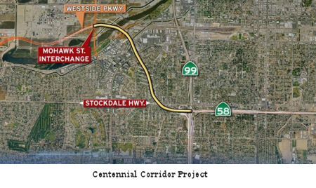
proposed Centennial Corridor project, which would link Route 58 east of
Route 99 with the Westside Parkway freeway at Truxtun Avenue.
In August 2013, the first segment of the five-mile,
$164.3 million Westside Parkway opened between Truxtun Avenue west of
Route 99 and Allen Road. The parkway’s final $30.1 million
segment, from Allen Road to the Heath Road and Stockdale Highway
intersection, is due to be completed in 2014. Will it be a state highway?
Initially, no. The Westside Parkway, from Truxtun Avenue to Stockdale
Highway/Heath Road, will be a city-owned and operated facility when it
first opens later this year. However, Caltrans is the lead agency for the
proposed Centennial Corridor project, which would link Route 58 east of
Route 99 with the Westside Parkway freeway at Truxtun Avenue.
In December 2020, the CTC approved the recommendation
of route adoption for Route 58 as a new freeway alignment from 0.3 miles
east of Heath Road to Coffee Road as part of the Route 58 corridor
improvements. The Commission approved the Resolution for Future
Consideration of Funding for the Final Environmental Impact Report (EIR)
via Resolution E-18-30 during the March 2018 Commission meeting, and the
Department signed a revalidation form on June 1, 2020. The Department
approved the Route Transfer Report on October 15, 2020. In
1973, the Kern Council of Governments (Kern COG) prepared the 1990
Transportation Plan and Program and the County prepared the Rosedale
General Plan, each identifying the “Westside Freeway,” now
known as WSP, as a major circulation element. Studies for this transfer of
highway location on the Route 58 corridor began in 1992 with a Tier 1 EIR/
Environmental Impact Statement (EIS). In 2001, the Department, as the
California Environmental Quality Act (CEQA) lead agency, and the FHWA, as
the National Environmental Policy Act (NEPA) lead agency, approved the
environmental document that evaluated two alignment alternatives for the
corridor.
Construction of WSP, which was intended to be a State highway, began in
2008 and was completed in April 2015. Due to work proposed on Route 99,
the Department approved the City’s Project Report and Final EIR/EIS
for the Centennial Corridor Project on December 4, 2015. That
environmental document cleared the route to be transferred into the SHS
and this freeway adoption. In 2016, the Department began evaluating WSP to
determine the feasibility of the route transfer. As a result, certain
areas of WSP were found to need remediation before transfer into the SHS.
Between 2017 and 2020, the City completed the required remediation work to
the Department's satisfaction. The proposed Route 58 freeway alignment
along WSP is a 6-mile-long, 4 to 6-lane freeway with 12-foot lane widths
and 10-foot shoulder widths, and is located approximately 1-2 miles south
of the current Route 58.
(Source: October 2020 CTC Agenda, Agenda Item
2.3a.(2))
There are several concurrent actions associated with
the transfer of highway location that are being presented to the
Commission on this month’s agenda for their approval. This request
is for the Freeway Route Adoption, an action item under Reference
2.3a.(2). Separate requests are being submitted for the Transfer of
Highway Location, an action item under Reference 2.3a.(1), the
relinquishment of three segments of the current Route 58 to the City and
County within their respective jurisdictions, an action item under
Reference 2.3c.(2), and the funds transfer from the Department to the
County, an action item under Reference 2.5b.(4). All of these associated
actions must be approved by the Commission for this Highway Route Adoption
to be approved. If any of the concurrent actions presented above are not
approved, then the Transfer of Highway Location as a whole is not
approved, and all prior associated approvals are nullified. The approval
of both route adoption book items will allow for the execution of Freeway
Agreements with the City.
(Source: October 2020 CTC Agenda, Agenda Item
2.3a.(2))
Related to the route adoption, in December 2020, the
CTC also relinquished one segment of (now former) Route 58: 06-Ker-58-PM
45.5/46.0 Right of way on the superseded portion of Route 58 (Rosedale
Highway) in the city of Bakersfield, from Jenkins Road to Van Buren Place.
The City agreed to waive the 90-day notice requirement and accept title
upon relinquishment by the State under the terms and conditions stated in
the relinquishment agreement dated October 27, 2020.
(Source: October 2020 CTC Agenda, Agenda Item
2.3c.(2))
2007 CMIA. The following project was submitted to the Corridor Mobility Improvement Account for funding: widening the Rosedale Hwy to 6 lanes from Allen Rd to Route 99 ($20,871K requested). Not recommended for funding. (just W of KER 45.975, since relinquished, to KER 50.611)
Centennial Corridor (~ KER 50.611 to KER T52.266)
 The Centennial Corridor project would be an extension of
Route 58; so upon approval, this project along with the Westside Parkway
would become the new alignment for Route 58, and the Westside Parkway
would become part of the state-owned and operated freeway system. West of
Heath Road, the westerly terminus of the Westside Parkway freeway, traffic
would use Stockdale Highway to access I-5; and so along with the Westside
Parkway, this portion of Stockdale Highway would then also become
designated as Route 58. The portion of existing Route 58 (Rosedale
Highway) between Mohawk Street and Allen Road is already operated and
maintained by either the city or the county. This portion of the roadway
was previously relinquished by Caltrans to the city and county to
facilitate the TRIP project to widen Rosedale Highway. But even with that
relinquishment, this portion of the roadway currently remains identified
as Route 58, so there is not any confusion to the traveling public. Once
the Westside Parkway and Stockdale Highway are designated as Route 58, the
remaining un-relinquished portions of the current alignment of Route 58
between Route 99 and I-5 would then also become city- and county-operated
and maintained roadways (except for the short north-south segment of
roadway that Route 58 and Route 43 share, which would remain under state
jurisdiction as Route 43).
The Centennial Corridor project would be an extension of
Route 58; so upon approval, this project along with the Westside Parkway
would become the new alignment for Route 58, and the Westside Parkway
would become part of the state-owned and operated freeway system. West of
Heath Road, the westerly terminus of the Westside Parkway freeway, traffic
would use Stockdale Highway to access I-5; and so along with the Westside
Parkway, this portion of Stockdale Highway would then also become
designated as Route 58. The portion of existing Route 58 (Rosedale
Highway) between Mohawk Street and Allen Road is already operated and
maintained by either the city or the county. This portion of the roadway
was previously relinquished by Caltrans to the city and county to
facilitate the TRIP project to widen Rosedale Highway. But even with that
relinquishment, this portion of the roadway currently remains identified
as Route 58, so there is not any confusion to the traveling public. Once
the Westside Parkway and Stockdale Highway are designated as Route 58, the
remaining un-relinquished portions of the current alignment of Route 58
between Route 99 and I-5 would then also become city- and county-operated
and maintained roadways (except for the short north-south segment of
roadway that Route 58 and Route 43 share, which would remain under state
jurisdiction as Route 43).
(Source: Bakersfield Californian, 7/28/13, 2/24/13)
Note that there are no plans to relocate Route 58 off Rosedale Highway. There are plans to transfer jurisdiction over Rosedale Highway to the city of Bakersfield. When this transfer occurs, the route will still be signed as Route 58 but will be relinquished to the City. Relocation of Route 58, in this particular question to the Westside Pkwy or North Beltway most likely will not occur, because these facilities will be designed as local freeways (Update: Future plans changed this: there are plans to make the new Westside Parkway/Centennial Corridor Route 58 after it is completed.).
In October 2015, it was reported that the City of
Bakersfield was considering buying the Wild West Shopping Center at the
end of Route 58 at South Real Road for about $7.9 million. The shopping
center would be razed to make way for the Centennial Corridor that will
connect Route 58 and Route 99 to the Westside Parkway. The nearly 5 acre
parcel sits where westbound Route 58 dead-ends into Route 99. For years
extending freeway access on Route 58 to the west side has been a top city
priority. Once the Centennial Corridor is constructed, it will link up
with the existing Westside Parkway. But in its path are dozens of existing
homes and businesses including the Wild West center.
(Source: Kern Golden Empire, 10/14/2015; KVPR, 10/14/2015)
In October 2015, it was also noted why Caltrans omitted transition ramps for the sorthbound Route 99 to the Centennial Corridor (Route 58) west, and from the Centenial Corridor (Route 58) east to the Route 99 northbound. This is because Caltrans notes that projected SB Route 99 to WB Route 58 movements and EB Route 58 to NB Route 99 would be "nominal."
In early 2017, Derek updated his Centennial Corridor blog to document the destruction of single family housing along the right of way of the Centennial Corridor.
In April 2017, there was an update on the the Route 58
beltway improvements that connect to the Centennial Corridor. This project
provides traffic improvements along Route 58, from Route 99 to Cottonwood
Road, and adds a lane in either direction along Route 99 in the area
between Ming Avenue and Wilson Road. The project is 60 percent complete;
completion expected in early 2018. Work on the pump plant, which removes
water that collects under the road, on northbound Route 99 near Ming
Avenue continues. Falsework, or temporary support, for the new connector
bridge for Route 99 to eastbound Route 58 is nearly complete. Crews will
begin installing steel for the bridge stems and bottom frame in May 2017.
Work to widen the bridges at P Street, the Bakersfield Corral Overhead (a
railroad bridge), and Madison Street are also underway. Lastly, multiple
retaining and sound walls are being constructed along Route 58 on both
sides of the freeway. Walls and barrier rails are also under construction
along the on- and off-ramps at Chester Avenue, H Street and Union Avenue.
(Source: Bakersfield.Com, 4/20/2017)
With respect to the Centennial Corridor itself, which
connects Route 58 to the Westside Parkway with possible connections to
southbound Route 99, the April update noted the following: The Design
Phase is 65 percent complete; and right-of-way acquisition is 98 percent
complete. Final design, right-of-way acquisitions of single-family
properties, and demolition activities are underway. To date, 202 of the
222 houses and retail properties have been demolished. The City Council
has approved purchase agreements for 192 single family properties (99
percent of what must be acquired); nine multi-family properties (100
percent of what must be acquired); and 17 commercial/industrial properties
(89 percent of what must be acquired). Sewer, local streets, screen wall
and sound wall packages are being prepared and work is expected to begin
in summer 2017. On March 29, the City Council awarded the $41.1 million
contract for the Kern River Bridge Improvements Project to Security Paving
Company.
(Source: Bakersfield.Com, 4/20/2017)
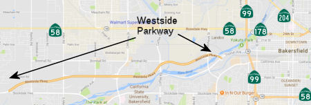
In July 2017, I was informed via email that once the Centennial Corridor is project is completed, the Westside Parkway will be designated as Route 58 and Stockdale Highway will be adopted as a temporary alignment for Route 58 westward to I-5, pending completion of a new freeway alignment. [In the map above, the] purple line shows the Centennial Corridor alignment that has been selected and is under construction. The orange line shows the Westside Parkway and the red line shows the interim alignment along Stockdale Highway, which will eventually be replaced by a new freeway alignment that will run to the southwest of the terminus of the Westside Parkway and connect with I-5 a couple of miles north of its junction with Route 43.
In December 2017, it was reported that the Westside
Parkway has essentially been completed since 2015 aside from the
Centennial Corridor. The Centennial Corridor is a 1 mile gap between the
east end of the Westside Parkway and the current ramp junction of Route 58
and Route 99. At present moment 99% of land parcels required to finish the
Centennial Corridor gap have been acquired and construction of rerouting
sewers has recently begun.
(Source: Gribblenation Blog, Route 58 - Westside Parkway)
The 2018 STIP, approved at the CTC March 2018 meeting, appears to have a number of allocations (shown as local) for this route: PPNO 3705, Rt 58-Westside Parkway Connector Mainline-Ph1, upping the total funding from $33,001K to $63,211K for construction in FY19-20; PPNO 6943, Rt 58-Westside Parkway Connector Interchange-Ph2, for $30,000K in FY22-23.
In June 2018, it was reported that on June 8, the U.S.
Department of Transportation released more than $1.5 billion in grants to
fund what it calls "critical freight, highway, and bridge improvements"
via the Infrastructure for Rebuilding America or "INFRA" program created
by the Fixing America's Surface Transportation (FAST) Act of 2015. As
required by the FAST Act, USDOT notified Congress on June 5 about the 26
projects selected to receive the $1.535 billion worth of grants via the
INFRA program; triggering a mandatory 60-day congressional review period
before the agency can, in fact, award them. One of these grants was for
"Centennial Corridor State Route 58/99 Freight Improvement Project", with
a proposed award of $ 50,000,000 out of a total project cost of $
386,637,000.
(Source: AASHTO Jounal, 6/8/2018; USDOT Reportof
Awards Under 23 U.S.C. 117 During Fiscal Years (FY) 2017 and FY 2018,
6/4/18)
In August 2018, the CTC received notice of a State Transportation Improvement Program (STIP) amendment to authorize the project to proceed as an Assembly Bill (AB) 3090 reimbursement arrangement (the amendment was approved in October 2018). This would permited the KCOG and Bakersfield to advance the construction of the Westside Parkway – Route 58 Connector Mainline – Phase 1 (Centennial) Project (PPNO 3705) with local funds, with the AB 3090 reimbursement over a three-year period beginning in Fiscal Year (FY) 2019-20. The approximately 20 mile long Centennial Corridor, defined in the Centennial Corridor environmental document, spans from I-5 to Cottonwood Road east of Route 99. Since approximately 1998, the City of Bakersfield and the Department have delivered major improvements to the corridor toward developing the ultimate project, which included the Westside Parkway, the Route 58 Gap Closure project, and the Route 58/Route 99 Bakersfield Freeway Connector project. The primary purpose of the Centennial Corridor, also referred to as Westside Parkway or Route 58 Corridor, is to improve regional and inter-regional travel and goods movement along Route 58, between the junctions with Route 99 and I-5. The fiscal challenges have required that the improvements be phased as funds became available, through the STIP, Local Measure, federal programs and most recently Senate Bill 1 Trade Corridor Enhancement Program.
The project was originally programmed for construction
in the 2012 STIP for delivery in FY 2015-16. In the subsequent STIP cycles
it was repeatedly pushed out to future years due to insufficient STIP
funding capacity, and most recently in the 2018 STIP it was pushed out to
FY 2019-20 and split into two phases, Phase 1 and Phase 2. Phase 1
primarily provides improvement to the mainline connectors and is ready to
proceed to construction. The Westside Parkway Interchange Phase 2
connector is programmed in FY 2022-23 and the final connector phase at I-5
remains to be programmed. Every effort is being made to obtain and secure
funding to complete the improvements in the corridor. This project remains
the top priority for the region.
(Source: August 2018 CTC Agenda Item 2.1b.(3);
October 2018 CTC Agenda Item 2.1a.(3))
In October 2018, it was reported that the Belle Terrace
overpass would be closed until spring 2020. The closure of this road that
crosses over Route 99 is part of the Centennial Corridor project. The
Belle Terrace overpass is 55 years old and shorter than the current
standard. It will also need to be widened to accommodate additional lanes
beneath it when Route 99 is widened. The northbound Route 99 exit to Wible
Road/Stockdale Highway is also slated to close permanently on 11/14/2018.
In conjunction with the Belle Terrace bridge closure, all traffic will
shift to the west side of Wible Road between Ming Avenue and Route 58,
with one lane in each direction. Traffic signals will be set to flashing
red at the shopping center just north of Ming and at Belle Terrace. In
addition to the closure of the overpass, Belle Terrace access will be
closed on the east side of Wible Road. Drivers won’t be able to
enter or exit Belle Terrace at that location on Wible Road. Drivers will
need to follow a posted detour through the end of 2018.
(Source: Bakersfield Now, 10/26/2018)
In May 2019, the CTC approved allocating an additional
$3,300,000 for the previously approved SHOPP Operational Improvement
project (PPNO 6891) on Route 99 and Route 58 in Kern County, to complete
construction. The project will widen traffic lanes, add an auxiliary lane
and improve signs on northbound (NB) Route 99 between Ming Avenue and
Route 58. The project will also replace the Belle Terrace Overcrossing
(OC) and reconstruct the NB Route 99/EB Route 58 connector. The project is
designated as a Financial Contribution Only (FCO) and therefore is not
eligible for G-12 authority. This project is located within a main freight
corridor for California funded with various local funds, SB 1 funds, SHOPP
funds and federal grants. Many of these projects are in various stages of
construction. The overall cost of these projects is estimated to be over
$1 billion dollars. In March 2018, the Commission allocated $30,960,000 in
Construction Capital, and $0 in Construction Support. The City is funding
the cost of Construction Support in the amount of $3,850,000. A
cooperative agreement (Co-Op) between the Department and the City,
designates the City as the construction implementation agency, responsible
for contract administration and associated support cost. The Department,
as a project sponsor, provides project oversight and funding for
additional Construction Capital cost incurred during construction. The
$30,960,000 allocation provided to the City is being invoiced and the
Department is reimbursing for actual allowable costs incurred and paid to
the contractor. In June 2018, the City augmented the allocated
Construction Capital funds and awarded the project contract for
$32,460,000. Construction began in October 2018; the contract status is
currently active with 27 percent of the construction bid items completed.
The project is expected to be completed by April 2020. Since the start of
construction, the project has incurred a funding shortfall due to
agreed-upon contract Change Orders (CO). The City has negotiated with the
contractor, and they both agreed on the amount needed to pay for these
COs, and the Department concurred. The total amount needed to pay for
these COs is $3,500,000. Based on funding proportions and the terms of the
Co-Op agreement , the City will provide $200,000 in local funds, and SHOPP
funds will provide $3,300,000. As with the original allocation, the
$3,300,000 allocation provided to the City is to be invoiced and the
Department will reimburse for actual allowable costs incurred and paid to
the contractor. The Department is requesting a supplemental fund amount of
$3,300,000 in Construction Capital to complete the construction of this
project. Since the City is funding the total cost of Construction Support,
the Department is not requesting any Construction Support funds. When this
supplemental request is approved, the Department and the City have agreed
to amend the Co-Op, requiring that any future cost increases in
construction will not come from SHOPP funds. A major portion of the
construction cost increase is due to differing site conditions at the soil
nail walls. Retaining Walls No. 6 and 62 were type-selected as soil nail
walls based on their proximity to existing Wible Road, and the need for
“top-down” construction. Field soil investigation prior to
wall design, including multiple soil test borings, revealed the existence
of layers of loose to medium dense sands. The geotechnical report did
include measures to mitigate loose, caving sandy soil during construction.
These measures included constructing a berm, using temporary shotcrete to
stabilize the excavation, and using full length temporary casings.
Furthermore, stability testing would be performed to determine the
acceptable lift height of soil and exposure time during excavation. The
wall design option as a soil nail wall type remained unchanged through the
course of design and went through all the required design and
constructability reviews before advertising the project contract. Using
over 2,000 soil nails, the 24-foot-high retaining wall supports a 3,500
feet embankment consisting of loose, sandy soil. During construction,
excavation at the soil nail wall location revealed a more dominant
presence of loose, less competent soils than anticipated and field
excavation activities were halted. The Construction Manager then
collaborated with the Contractor and Geotechnical Engineer to develop a
timely and cost-effective solution that involves “soil mixing”
to stabilize the soil and preventing caving of over 56,000 linear feet of
soil nail bores. Another significant portion of the construction cost
increase is the result of the discovery of an AT&T abandoned conduit
during field preparation to demolish the bridge. The conduit was
discovered inside the bridge and was determined to contain asbestos. An
earlier asbestos survey, that was conducted during the design phase, did
not find any asbestos on the Belle Terrace Bridge. The asbestos conduit
removal will require additional costs to be safely detached prior to
bridge demolition, as contractors are required to adhere to special safety
procedures when dealing with items containing asbestos. The cost
associated with this operation is $550,000. The bridge demolition
operation has been delayed to accommodate a change in the means and
methods for demolition of the bridge and mitigation of the asbestos
containing conduit. The remainder of the cost increase, $475,000 is due to
the additional field work needed to excavate and remove “Unknown
Buried Manmade Objects”; consisting of large, unearthed chunks of
concrete rubble at the project site.
(Source: May 2019 CTC Minutes, Agenda Item
2.5e.(1))
In June 2019, the CTC approved $6,321,000 for an FY
2019-20 AB 3090 reimbursement for the Westside Parkway - Phase 1
(Centennial) project.
(Source: June 2019 CTC Minutes, Agenda Item
2.5c.(7))
In March 2020, the CTC approved the 2020 STIP, which
appeared to delete the programmed funding for PPNO 3705A "Rt 58-Westside
Parkway Connector Interchange-Ph2"
(Source: March 2020 CTC Agenda, Item 4.7, 2020 STIP
Adopted 3/25/2020)
In October 2022, it was reported that the Centennial
Corridor project was nearing the finish line. Work was progressing on the
freeway overpass at Route 99 and Stockdale Highway, as well as the last
800' connecting the overpass. The Centennial Corridor project is comprised
of four different phases. The overpass consists of two projects, one
called the Mainline and the other one called the Bakersfield Freeway
Connector, The Bakersfield Freeway Connector is should be completed by the
end of 2022. It consists of that loop ramp from westbound Route 58 to
southbound Route 99 and everything associated with the Ming offramp,
southbound Ming offramp. The southbound Ming Avenue exit is due to open in
October 2022 after a long closure, but it will look different. In order to
separate them from cars merging from the new eastbound connector onto
southbound Route 99, motorists will have to commit to taking the Ming
offramp north of Stockdale Highway – more than a mile before they
actually exit. But that creates another problem – how to keep cars
exiting at Stockdale Highway safely apart from cars getting in line to
exit farther down at Ming. That’s why Caltrans plans to permanently
close the Stockdale exit. City officials oppose that – they want to
maintain direct freeway access to Cal State Bakersfield, Mercy Southwest
Hospital and the Park at Riverwalk and an important developing commercial
corridor.
(Source: KGET Bakersfield 17, 10/12/2022)
In December 2022, the CTC was noticed about the
following forthcoming STIP amendment: Rescind $25,593,000 of
Regional Improvement Program (RIP) funding from the Construction
phase of the Extend Hageman Road Easterly Across Route 99 and
connect to Route 204 in Bakersfield project (PPNO 06-3525; EA
484500; 06-Ker-5 26.700/27.200) and program $24,093,000 of the RIP
funds to the Construction phase of the new Centennial Corridor EB
Route 58 to NB Route 99 Loop Connector project (PPNO 06-8029; EA
48467; 06-Ker-58 T52.200/R52.400), in Kern County. According to the
background in the agenda item, the RIP funds from the CON phase of the
Hageman Flyover project are being reprogrammed to the CON phase of
Bakersfield Freeway Connector loop project because of a potential delay in
the Hageman Flyover project. The Centennial Corridor EB 58 to
NB 99 Loop Connector project is in the City of Bakersfield - from
the eastbound Route 58 freeway to existing northbound Route 99. At
the Route 58/Route 99 Interchange, construct a new connector starting west
of Route 99, on the south side of Route 58 with a bridge spanning over
Route 99 between postmile T52.2/R 52.40, and connecting to northbound
Route 99 between postmile 23.2/23.7.The Bakersfield Freeway Connector Loop
project proposes to construct a loop connector for the EB Route 58 to NB
Route 99 movement at the existing Route 58/Route 99 interchange. In its
existing condition, it takes the traveling public an additional 2.4 miles
to make the connection from EB Route 58 to NB Route 99. The proposed
Bakersfield Freeway Connector Loop project will provide a direct
connection by providing exit at EB Route 58 approximately 250 feet west of
Route 99. The existing EB Route 58/Route 99 grade separation bridge
will be widened to accommodate the connector. The loop ramp will cross
over Wible Road before connecting onto the NB Route 99/Ming Avenue Bypass
On-Ramp. A bridge will be constructed over Wible Road and a
retaining wall will be constructed adjacent to the existing NB Route 99 to
EB Route 58 connector. The Ming Avenue Bypass On-ramp will be re-aligned
to the east and the elevation of the on-ramp will be raised to meet the
connector, which will then merge with the Ming Avenue Bypass On-Ramp,
retaining walls are proposed at this location along NB Route 99 and the
proposed connector. After the merge, the single lane will then merge with
NB Route 99 prior to the existing westbound (WB) Route 58 to NB Route 99
Connector. Each phase of the Centennial Corridor Project has been approved
and proceeded to CON except for the Route 58/99 Bakersfield Freeway
Connector Phase 2 project (EA 48467). The supplemental project report for
this project will be approved in late November 2022 and final design will
be completed by June 2023 allowing the project to proceed to CON in Fall
2023. The revised totals show ($ × 1,000): Const Cap 24,093;
PA&ED 500; PS&E 1,500.
(Source: December 2022 CTC Agenda, Agenda Item
2.1b.(2))
In July 2023, it was reported that the California
Transportation Commission awarded $9.3 million for the final ramp for the
interchange at Route 99 and Route 58 as part of more than $2.2 billion to
fund projects across the state. According to a news release issued by
KernCOG, the Route 58 mainline connection from Route 99 to the 7-mile
Westside Parkway freeway is scheduled to open to traffic with a
ribbon-cutting in September 2023, providing connectivity to I-5 via
Stockdale Highway west of Bakersfield. Once the connector is open, the
agency said, two more Route 99 / Route 58 interchange ramps will be
completed over the next several years — the Route 58 westbound to
Route 99 northbound and the Route 99 southbound to Route 58 westbound
movements. According to Caltrans, the estimated construction cost for the
Centennial Corridor Southbound Route 99 and westbound Route 58 Connector
project is more than $29 million. It is expected to be complete by summer
2028. The funding to complete the final ramp for the 99-to-58
freeway-to-freeway interchange comes from the Trade Corridor Enhancement
Program. The program is funded by state and federal fuel taxes, including
the Senate Bill 1 Transportation Improvement Fee.
(Source: Tehachapi News, 7/9/2023)
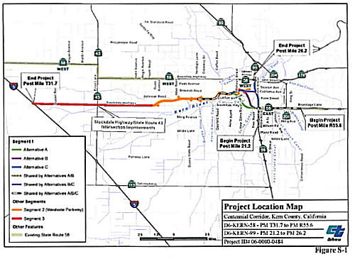
 In August 2023, the CTC approved for future consideration of funding
06-Ker-58, PM T31.7/R55.6 06-Ker-99, PM 21.2/26.2. Centennial
Corridor Project. Construct a new alignment for Route 58 to
provide a continuous route along Route 58 from Cottonwood Road on existing
Route 58, east of Route 99 to I-5. Improvements to Route 99 from Wilson
Road to Gilmore Avenue would also be required for the connection with
Route 58, in Kern County. The project is located on Route 58 from PM T31.7
to PM R55.6, and on Route 99 from PM 21.2 to PM 26.2, in Kern County. The
Department proposes to construct a new alignment for Route 58, to provide
a continuous route from Cottonwood Road on existing Route 58, east of
Route 99 to I-5. Improvements to Route 99, from Wilson Road to Gilmore
Avenue, would also be required for the connection with SR 58. The project
is currently programmed in the 2022 STIP for a total of $26,093,000, which
includes Construction (Capital). Construction is estimated to begin in
2025-26. The scope, as described for the preferred alternative, is
consistent with the project scope as programmed by the Commission in the
2022 STIP. A copy of the FEIR has been provided to Commission staff. The
Commission approved the project for future consideration of funding on
March 21, 2018, under Resolution E-18-30. Since the approval of the FEIR,
there have been changes to the project and an Addendum was prepared
pursuant to CEQA. These changes include the addition of a loop connector
for the eastbound Route 58 to NB Route 99 movement at the Route 58/Route 99 interchange and associated adjustments. The loop connector was not
included in the original FEIR due to lack of available funding at the
time. The proposed loop connector is located within the approved
archaeological and architectural Area of Potential Effects, within the
approved Biological Study Area, and within Department right of way. There
are no changes to avoidance, minimization, and/or mitigation measures
since approval of the FEIR in December 2015. The proposed loop connector
would have no significant environmental effects or substantial increase in
the severity of previously identified significant effects. The project
changes do not meet the criteria outlined in CEQA Guidelines Section 15162
and Section 15163 to prepare a Subsequent or Supplemental FEIR. The
Department subsequently completed an Addendum to the FEIR pursuant to
CEQA. The Department has approved this project for construction. This
approval and the Addendum will satisfy the environmental requirements for
this stage of the planning process.
In August 2023, the CTC approved for future consideration of funding
06-Ker-58, PM T31.7/R55.6 06-Ker-99, PM 21.2/26.2. Centennial
Corridor Project. Construct a new alignment for Route 58 to
provide a continuous route along Route 58 from Cottonwood Road on existing
Route 58, east of Route 99 to I-5. Improvements to Route 99 from Wilson
Road to Gilmore Avenue would also be required for the connection with
Route 58, in Kern County. The project is located on Route 58 from PM T31.7
to PM R55.6, and on Route 99 from PM 21.2 to PM 26.2, in Kern County. The
Department proposes to construct a new alignment for Route 58, to provide
a continuous route from Cottonwood Road on existing Route 58, east of
Route 99 to I-5. Improvements to Route 99, from Wilson Road to Gilmore
Avenue, would also be required for the connection with SR 58. The project
is currently programmed in the 2022 STIP for a total of $26,093,000, which
includes Construction (Capital). Construction is estimated to begin in
2025-26. The scope, as described for the preferred alternative, is
consistent with the project scope as programmed by the Commission in the
2022 STIP. A copy of the FEIR has been provided to Commission staff. The
Commission approved the project for future consideration of funding on
March 21, 2018, under Resolution E-18-30. Since the approval of the FEIR,
there have been changes to the project and an Addendum was prepared
pursuant to CEQA. These changes include the addition of a loop connector
for the eastbound Route 58 to NB Route 99 movement at the Route 58/Route 99 interchange and associated adjustments. The loop connector was not
included in the original FEIR due to lack of available funding at the
time. The proposed loop connector is located within the approved
archaeological and architectural Area of Potential Effects, within the
approved Biological Study Area, and within Department right of way. There
are no changes to avoidance, minimization, and/or mitigation measures
since approval of the FEIR in December 2015. The proposed loop connector
would have no significant environmental effects or substantial increase in
the severity of previously identified significant effects. The project
changes do not meet the criteria outlined in CEQA Guidelines Section 15162
and Section 15163 to prepare a Subsequent or Supplemental FEIR. The
Department subsequently completed an Addendum to the FEIR pursuant to
CEQA. The Department has approved this project for construction. This
approval and the Addendum will satisfy the environmental requirements for
this stage of the planning process.
(Source: August 2023 CTC Agenda, Agenda Item 2.2c.(2) Item 6)
In October 2023, the CTC approved the following STIP
allocation: $28,500,000. 06-Ker-58 T52.2/R52.4; 06-Ker-99 23.2/23.7. PPNO
06-8029; ProjID 0623000083; EA 48467. Centennial Corridor EB58 to
NB99 Loop Connector. In the City of Bakersfield from the
eastbound Route 58 to existing northbound Route 99. At the Route 58/Route 99 Interchange, construct a new connector starting west of Route 99, on
the south side of Route 58 with a bridge spanning over Route 99 between
postmile T52.2/R 52.40, and connecting to northbound Route 99 between
postmile 23.2/23.7. CEQA - EIR, 12/04/2015; Re-validation 12/02/2022. NEPA
- EIS, 12/04/2015; Re-validation 12/02/2022. Right of Way Certification:
08/23/2023. Additional $4,407,000 increase will be funded with future Kern
RIP shares. Future consideration of funding approved under Resolution
E-18-30; March 2018. An Addendum for the previously approved Future
Consideration of Funding was approved under Resolution E-23-122A; August
2023. Allocation: CONST $24,093,000 $28,500,000.
(Source: October 2023 CTC Agenda, Agenda Item 2.5c.(2))
In December 2023, the CTC approved for future
consideration of funding the following project for which a FEIR and an
Addendum have been completed: Centennial Corridor Project. Route 58 and Route 99 in Kern County. Construct a new alignment for Route 58, to
provide a continuous route from Cottonwood Road on existing Route 58, east
of Route 99 to I-5. Improvements to Route 99, from Wilson Road to Gilmore
Avenue, would also be required for the connection with Route 58, in Kern
County. (06-Ker-58, PM T31.7/R55.6; 06-Ker-99, PM 21.2/26.2; PPNO 06-8030)
The project is located on Route 58 from PM T31.7 to PM R55.6, and on Route 99 from PM 21.2 to PM 26.2, in Kern County. The Department proposes to
construct a new alignment for Route 58, to provide a continuous route from
Cottonwood Road on existing Route 58, east of Route 99 to I-5.
Improvements to Route 99, from Wilson Road to Gilmore Avenue, would also
be required for the connection with Route 58. The project is currently
programmed in the Trade Corridor Enhancement Program (TCEP). The total
programmed amount, which includes Right of Way (Capital), and Construction
(Capital) is $13,400,000. Construction began in 2023-2024. The scope, as
described for the preferred alternative, is consistent with the project
scope as programmed by the Commission in the TCEP. A copy of the FEIR has
been provided to Commission staff. The Commission approved the project for
future consideration of funding on March 21, 2018, under Resolution
E-18-30 and August 17, 2023, under Resolution E-23-122A. Since the
approval of the FEIR and Addendum, there have been changes to the project
and a new Addendum was prepared pursuant to CEQA. These changes include
the construction of a southbound Route 99 to westbound Route 58 connector
ramp. The ramp would be constructed at the current location of the
southbound Route 99 to Stockdale off-ramp. The existing Stockdale off-ramp
would be permanently closed. The connector ramp would be a fly-over
structure, which would cross over Stockdale Highway, the existing
westbound Route 58 to southbound Route 99 loop connector, and Real Road
before merging to the westbound Route 58. West of Real Road, an existing
retaining wall would be reconstructed to accommodate the new connector
ramp. An additional 470-foot auxiliary lane would be constructed on
westbound Route 58 to accommodate merging. There are no substantial
changes proposed in the new connector ramp that would require major
revisions of the FEIR due to involvement of new significant environmental
effects or a substantial increase in the severity of previously identified
significant effects. The project changes do not meet the criteria outlined
in CEQA Guidelines Section 15162 and Section 15163 to prepare a Subsequent
or Supplemental FEIR. The Department subsequently completed an Addendum to
the FEIR pursuant to CEQA. The Department has approved this project for
construction. This approval and the Addendum will satisfy the
environmental requirements for this stage of the planning process.
(Source: December 2023 CTC Agenda, Agenda Item 2.2c.(2))
In January and February 2024, it was report that the
final piece of the Centennial Corridor in Bakersfield was opening, with
the opening of the connection between the unlinked east and west halves of
Route 58 with north-south Route 99. Almost 200 homes and businesses were
demolished to make room for the freeway footprint, including a number of
homes in the Westpark and Garnsey neighborhoods of west-central
Bakersfield. Beyond the new six-story overpass that delivers eastbound
traffic onto Route 99 south, the southbound Ming Avenue off-ramp has been
redesigned and drivers must commit to the dedicated lane a half-mile
before they actually exit the freeway, or they’ll miss it. An
important milestone was the Westside Parkway, completed in 2014, which has
become the western portion of the Centennial Corridor. As of February, 18,
2024, the Centennial Corridor was officially open to westbound traffic
from the Westside Parkway and eastbound Westside Parkway to Route 58,
Route 99, and Ming Avenue. Drivers can access the corridor from westbound
Highway 58 heading towards the Westside Parkway and from the eastbound
Westside Parkway to Route 58, Route 99, and Ming Avenue. The northbound
Route 99 exit and flyover ramp to westbound Route 58 remained closed until
construction completes. The Centennial Corridor freeway project demolished
a significant swath of Bakersfield's Westpark neighborhood, home to an
estimated sixty percent people of color. About 1,000 residents were
displaced as Caltrans removed 271 homes, plus fifteen multi-family
buildings (totaling 110 housing units), and 36 commercial structures (with
121 businesses).
(Source: KGET, 1/15/2024; Bakersfield Now, 2/20/2024; Streetsblog 2/9/2024)
Naming Before the move of Route 58 to the Westside Parkway, Route 58 was routed along "Rosedale
Highway". Rosedale Highway was named by location, based on the
community of Rosedale. Rosedale is in Kern County, California, a was
formerly a country town 10 miles west of Bakersfield. As of 2021, it is
now surrounded by suburban housing and currently has the highest household
income in Kern County, according to Census estimates. Rosedale was founded
in 1891 as a colony of English farmers. A post office operated at Rosedale
from 1891 to 1913.
Before the move of Route 58 to the Westside Parkway, Route 58 was routed along "Rosedale
Highway". Rosedale Highway was named by location, based on the
community of Rosedale. Rosedale is in Kern County, California, a was
formerly a country town 10 miles west of Bakersfield. As of 2021, it is
now surrounded by suburban housing and currently has the highest household
income in Kern County, according to Census estimates. Rosedale was founded
in 1891 as a colony of English farmers. A post office operated at Rosedale
from 1891 to 1913.
(Image source: Deviant Art)
 Bakersfield is named after Colonel Thomas Baker, who tried to develop a waterway from Kern Lake to
San Francisco Bay in the early 1860s had a corral here know as "Baker's
field." In 1868 the name was transferred to the city.
Bakersfield is named after Colonel Thomas Baker, who tried to develop a waterway from Kern Lake to
San Francisco Bay in the early 1860s had a corral here know as "Baker's
field." In 1868 the name was transferred to the city.
(Image source: Find a Grave)
 The portion of Westside Parkway (future Route 58) between the Coffee Road offramp and the
Allen Road offramp on Route 58 in the County of Kern is named the “Harvey
L. Hall Memorial Highway”. It was named in memory of
Harvey L. Hall, who was a pioneer of modern emergency medical services in
California, fostered the concept of “Unity in Our Community,”
and was the City of Bakersfield’s 25th, and longest-serving, mayor.
Harvey Hall was born in Los Angeles in January 1941 at the Long Beach
Memorial Hospital, and was adopted at birth. He later attended Lowell and
Longfellow elementary schools, Washington and Golden State middle schools,
Bakersfield High School, Bakersfield College, and San Francisco City
College. Because of a dare to go on a ride-along in an ambulance in 1960,
Hall’s interest was piqued in becoming an ambulance driver and
sparked what would culminate in a 58-year career of caring for those in
need. With a vision to build the best ambulance company in America, Hall,
with a $15,000 bank loan, two ambulances, and his residence serving as
headquarters, founded Hall Ambulance Service, Inc., on February 10, 1971.
Hall worked tirelessly to build relationships within the medical community
and with his “customers,” and gained a reputation for
providing a five-star ambulance service that resulted in the surrounding
communities approaching him to bring his ambulance service to, ultimately,
88 percent of the County of Kern’s population as their exclusive
9-1-1 paramedic provider. Hall introduced the first mobile intensive care
paramedic program in the County of Kern in May 1975, dramatically
elevating the level of medical care that could be provided in the field,
while in 1990 the National Association of Emergency Medical Technicians
selected his ambulance service as one of the top three ambulance service
providers in the nation and, the following year, the ambulance service was
honored as the United States Paramedic EMS Service of the Year. In
December 2001, Harvey Hall elevated the care provided by his paramedics to
a higher level by launching Hall Air Ambulance and eight years later he
ushered in a new era of specialized medical transportation with the
creation of Hall Critical Care Transport, which provides both ground and
air regional interfacility transport solutions. Hall was a longtime member
of both the California Ambulance Association and the American Ambulance
Association. In 2015, Harvey Hall championed the cause to find solutions
to the growing gap between the cost to provide safety net ambulance
services to California’s most vulnerable residents and the
reimbursement for services paid by Medi-Cal by founding the 911 Ambulance
Provider’s Medi-Cal Alliance. On March 30, 1999, Harvey Hall
announced his candidacy for mayor on the steps of Centennial Plaza in the
City of Bakersfield with his message of “Unity in Our
Community” that was embraced by the voters, resulting in his winning
the March 2000 election with 62 percent of the vote. During his tenure
extending for four terms, Mayor Hall was eager to help recognize the
accomplishments, celebrations, and pride of Bakersfield’s diverse
population, presenting 1,836 proclamations and 10,750 Certificates of
Appreciation, performing 958 ribbon cuttings with his custom-made
oversized scissors, leading 91 groundbreakings, delivering 981 speeches,
extending 469 welcomes, hosting 452 foreign visitors, and participating in
64 military events. Mayor Hall started the Mayor Hall Freeway Litter
Cleanup Program, where, for 13 years, he personally led residents early on
Saturday mornings as they picked up litter along highway onramps and
offramps in the city. In 2008, when President George W. Bush called on
Mayor Hall to develop a plan to end homelessness in the Bakersfield
community, Mayor Hall introduced Home First: Kern County’s Plan to
End Chronic Homelessness, which brought together a coalition of
organizations to tackle the challenging issue of homelessness in our
communities. On May 19, 2017, California State University, Bakersfield,
awarded Mayor Hall an honorary Doctorate of Humane Letters for distinction
in his chosen field of endeavor, widely recognized eminence, and
demonstrated values consistent with those of higher education, and on his
birthday, in January 2018, Mayor Hall was inducted into the City of
Bakersfield’s Hall of Fame. Mayor Hall was the longest serving mayor
in the history of the City of Bakersfield. Hall passed away at 77 years of
age on May 19, 2018, surrounded by his family and with his three dogs at
his side. Named by Assembly Resolution ACR 64, Res. Chapter 138, Statutes of 2021, 09/17/21. Note: Technically, the Westside Parkway is not Route 58 as of October 2021,
and the segment of existing Rosedale Highway (shown by Google as part of
Route 58) between Coffee Road and Allen Road has been relinquished to
the City of Bakersfield. (Image source: Find a Grave)
The portion of Westside Parkway (future Route 58) between the Coffee Road offramp and the
Allen Road offramp on Route 58 in the County of Kern is named the “Harvey
L. Hall Memorial Highway”. It was named in memory of
Harvey L. Hall, who was a pioneer of modern emergency medical services in
California, fostered the concept of “Unity in Our Community,”
and was the City of Bakersfield’s 25th, and longest-serving, mayor.
Harvey Hall was born in Los Angeles in January 1941 at the Long Beach
Memorial Hospital, and was adopted at birth. He later attended Lowell and
Longfellow elementary schools, Washington and Golden State middle schools,
Bakersfield High School, Bakersfield College, and San Francisco City
College. Because of a dare to go on a ride-along in an ambulance in 1960,
Hall’s interest was piqued in becoming an ambulance driver and
sparked what would culminate in a 58-year career of caring for those in
need. With a vision to build the best ambulance company in America, Hall,
with a $15,000 bank loan, two ambulances, and his residence serving as
headquarters, founded Hall Ambulance Service, Inc., on February 10, 1971.
Hall worked tirelessly to build relationships within the medical community
and with his “customers,” and gained a reputation for
providing a five-star ambulance service that resulted in the surrounding
communities approaching him to bring his ambulance service to, ultimately,
88 percent of the County of Kern’s population as their exclusive
9-1-1 paramedic provider. Hall introduced the first mobile intensive care
paramedic program in the County of Kern in May 1975, dramatically
elevating the level of medical care that could be provided in the field,
while in 1990 the National Association of Emergency Medical Technicians
selected his ambulance service as one of the top three ambulance service
providers in the nation and, the following year, the ambulance service was
honored as the United States Paramedic EMS Service of the Year. In
December 2001, Harvey Hall elevated the care provided by his paramedics to
a higher level by launching Hall Air Ambulance and eight years later he
ushered in a new era of specialized medical transportation with the
creation of Hall Critical Care Transport, which provides both ground and
air regional interfacility transport solutions. Hall was a longtime member
of both the California Ambulance Association and the American Ambulance
Association. In 2015, Harvey Hall championed the cause to find solutions
to the growing gap between the cost to provide safety net ambulance
services to California’s most vulnerable residents and the
reimbursement for services paid by Medi-Cal by founding the 911 Ambulance
Provider’s Medi-Cal Alliance. On March 30, 1999, Harvey Hall
announced his candidacy for mayor on the steps of Centennial Plaza in the
City of Bakersfield with his message of “Unity in Our
Community” that was embraced by the voters, resulting in his winning
the March 2000 election with 62 percent of the vote. During his tenure
extending for four terms, Mayor Hall was eager to help recognize the
accomplishments, celebrations, and pride of Bakersfield’s diverse
population, presenting 1,836 proclamations and 10,750 Certificates of
Appreciation, performing 958 ribbon cuttings with his custom-made
oversized scissors, leading 91 groundbreakings, delivering 981 speeches,
extending 469 welcomes, hosting 452 foreign visitors, and participating in
64 military events. Mayor Hall started the Mayor Hall Freeway Litter
Cleanup Program, where, for 13 years, he personally led residents early on
Saturday mornings as they picked up litter along highway onramps and
offramps in the city. In 2008, when President George W. Bush called on
Mayor Hall to develop a plan to end homelessness in the Bakersfield
community, Mayor Hall introduced Home First: Kern County’s Plan to
End Chronic Homelessness, which brought together a coalition of
organizations to tackle the challenging issue of homelessness in our
communities. On May 19, 2017, California State University, Bakersfield,
awarded Mayor Hall an honorary Doctorate of Humane Letters for distinction
in his chosen field of endeavor, widely recognized eminence, and
demonstrated values consistent with those of higher education, and on his
birthday, in January 2018, Mayor Hall was inducted into the City of
Bakersfield’s Hall of Fame. Mayor Hall was the longest serving mayor
in the history of the City of Bakersfield. Hall passed away at 77 years of
age on May 19, 2018, surrounded by his family and with his three dogs at
his side. Named by Assembly Resolution ACR 64, Res. Chapter 138, Statutes of 2021, 09/17/21. Note: Technically, the Westside Parkway is not Route 58 as of October 2021,
and the segment of existing Rosedale Highway (shown by Google as part of
Route 58) between Coffee Road and Allen Road has been relinquished to
the City of Bakersfield. (Image source: Find a Grave)
 Other WWW Links Freeway
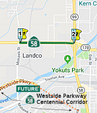 Mohawk Street near Bakersfield to Route 99.
Post 1964 Signage HistoryThis segment was created as a split of the segment from Route 43 to Route 99 in 2013, reflecting relinquishment in Bakersfield.
StatusWestside Parkway/Centennial Corridor
For the construction of the replacement Westside Parkway and Centennial Corridor that parallels this segment, see Segment (c) [3] above.
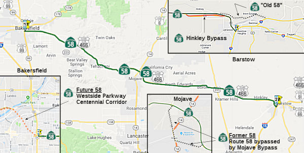 From Route 99 to Route 15 near Barstow via Bakersfield and Mojave.
Upon a determination by the commission that it is in the best interests of the state to do so, the commission may, upon terms and conditions approved by it, relinquish to the City of Bakersfield or the County of Kern the portion of Route 58 that is located within the city limits of that city if the city or county agrees to accept it. The following conditions shall apply upon relinquishment: (1) The relinquishment shall become effective on the date following the county recorder's recordation of the relinquishment resolution containing the commission's approval of the terms and conditions of the relinquishment. (2) On and after the effective date of the relinquishment, the relinquished portion of Route 58 shall cease to be a state highway. (3) The portion of Route 58 relinquished under this subdivision shall be ineligible for future adoption under Section 81. (4) For the portion of Route 58 that is relinquished under this subdivision, the City of Bakersfield or the County of Kern shall install and maintain within the jurisdiction of the city signs directing motorists to the continuation of Route 58. Added by AB 1858, Chapter 315, September 18, 2006.
In 2010, SB 1318 (9/29/10, Chapter 421) changed the last sentence to be "the City of Bakersfield or the County of Kern shall install and maintain within the jurisdiction of the city or county signs directing motorists to the continuation of Route 58."
Post 1964 Signage HistoryThis segment remains as defined in 1963.
Note: The Gribblenation Blog “California State Route 58 from CA 99 in Bakersfield east to Interstate 15 in Barstow” provides a good timeline of the construction of the segments of this route.
In 2006, Chapter 315 permitted relinquishment of the portion of this route in Bakersfield.
Pre 1964 Signage History This was a portion of US 466. Between US 101 and Bakersfield, US 466
consisted of the present-day Route 41 and Route 46. Between Bakersfield
and the Nevada border, US 466 ran concurrant with US 91, now I-15. See the
page on US 466, and the Gribblenation Blog entry on the Tehachapi to Interstate 15 in Barstow, for
information on how the US 466 routing diverged from the Route 58 routing.
This was a portion of US 466. Between US 101 and Bakersfield, US 466
consisted of the present-day Route 41 and Route 46. Between Bakersfield
and the Nevada border, US 466 ran concurrant with US 91, now I-15. See the
page on US 466, and the Gribblenation Blog entry on the Tehachapi to Interstate 15 in Barstow, for
information on how the US 466 routing diverged from the Route 58 routing.
The portion of the segment, from Mojave (LRN 4 / Route 99) to Barstow (US 91/I-15) was defined in 1919.
The portion of this segment between Bakersfield (LRN 4 / Route 99) and Mojave (LRN 23 / Route 14 / US 6) was defined in 1931. It representated the state assuming responsibility for a previous county road that had a class of traffic that qualified it for state jurisdiction. The original function of the county road was providing access to the Kern county seat from the far-flung Mojave desert region. It was also noted that the route serves as a relief and alternative for the Ridge Route.
Route 58 was adopted into the State Highway System in 1919 and was first paved in the late 1930s. The highway was constructed along the natural terrain, using prescriptive rights of way.
Over time, the original surface routing has been bypassed with freeway routings. Existing former surface routings include:
StatusRoute 99 to Cottonwood Road (~ KER R52.526 to KER R55.413)
2007 CMIA. The following project was submitted to the Corridor Mobility Improvement Account for funding: widening the route to 6 lanes between Route 99 and Cottonwood Rd. ($62,300K) (~ KER R52.526 to KER R55.413). Not recommended for funding. (just W of KER 45.975, since relinquished, to KER 50.611)
In January 2018, the CTC amended a previous SHOPP
allocation: $27,042,000. 06-Ker-58 R52.4/R55.5. Route 58 In Bakersfield
from Route 99 to Cottonwood Road (~ KER R52.526 to KER R55.413).
Outcome/Output: Rehabilitate pavement using Continuous Reinforced Concrete
Pavement (CRCP) and construct auxiliary lane. This project will improve
safety, ride quality, and traffic operations. Cost adjustment: CON ENG $3,410,000.
$4,055,000.
(Source: CTC Agenda, January 2018, Agenda Item
2.5b(1))
Cottonwood Road to Route 184 Improvements (~ KER R55.413 to KER 59.7)
 In August 2016, the CTC approved for future consideration of funding a project on Route 58
(06-Ker-58, PM R55.4/R59.7 — between Cottonwood and Route 184) in
Kern County that will rehabilitate the roadway on a portion of Route 58 in
the City of Bakersfield. The project is programmed in the 2016 State
Highway Operation and Protection Program. The total programmed amount is
$34,982,000 for capital and support. Construction is estimated to begin in
Fiscal Year 2016-17. The scope, as described for the preferred
alternative, is consistent with the project scope programmed by the
Commission in the 2016 State Highway Operation and Protection Program.
In August 2016, the CTC approved for future consideration of funding a project on Route 58
(06-Ker-58, PM R55.4/R59.7 — between Cottonwood and Route 184) in
Kern County that will rehabilitate the roadway on a portion of Route 58 in
the City of Bakersfield. The project is programmed in the 2016 State
Highway Operation and Protection Program. The total programmed amount is
$34,982,000 for capital and support. Construction is estimated to begin in
Fiscal Year 2016-17. The scope, as described for the preferred
alternative, is consistent with the project scope programmed by the
Commission in the 2016 State Highway Operation and Protection Program.
In July 2017, the CTC approved $37.3 million for pavement rehabilitation and roadway upgrades to a five-mile segment of Route 58 from Cottonwood Road to 0.3 mile east of the Route 58/Route 184 separation to repair damage caused by winter storms and heavy freight traffic.
In September 2016, it was reported by Gary Richards (but echoing a
response from Joe Rouse) that all the green paddle mile markers that had
once been on Route 58 and Route 14 have been removed. According to Joe,
Caltrans HQ Traffic Ops was approached by staff in District 9 about
removing the milepost markets, for the reasons that created confusion when
it came to responding to roadway incidents (for the CHP, Caltrans and
local law enforcement continue to use postmiles to locate roadway
incidents). Because mileposts are not a requirement in the California
MUTCD, Caltrans concurred with their request. The green mile markers were
located on the freeway portions of Route 58 from roughly Tehachapi to the
San Bernardino County line and on the freeway portions of Route 14 in Kern
County.
(Source: Joe Rouse on AAroads, 9/8/2016)
Tehachapi Climbing Lanes (Multiple segments: ~KER 76.3 to ~ KER R88.56)
 In January 2020, it was reported that Caltrans plans to
soon release to the public plans on three sections of truck-climbing lanes
that would allow motorists to pass big rigs traveling on Route 58 from
Bakersfield to Tehachapi. Caltrans' Project Initiation Document for the
State Route 58 Truck Climbing Project still needs final approval. It was
slated to be completed in Summer 2019. Lanes being considered are:
starting halfway between General Beale and Bena roads (~KER 71.409) and
ending shortly before Route 223 (~ KER 75.41); beginning shortly before
Bealeville Road (~ KER 76.886) and extending to Hart Flat (~ KER 80.24);
and starting before Broome Road (~ KER R84.992) and ending before the
Tehachapi Creek Bridge. The proposal at this point is to widen
asymmetrically on the outside shoulder. The layout proposed would include
a 14-foot truck climbing lane; however two of those feet would be
comprised of barrier striping. Some alternatives and challenges to each
location included widening or realigning Bena Road, removing or extending
Broome Road Bridge, and obtaining right-of-way for encroachment to the
parcels surrounding the new lanes. Even though there currently is no local
or state funding for the projects, Caltrans is eager to find money for the
preliminary environmental and engineering studies for all three
truck-climbing lanes.
In January 2020, it was reported that Caltrans plans to
soon release to the public plans on three sections of truck-climbing lanes
that would allow motorists to pass big rigs traveling on Route 58 from
Bakersfield to Tehachapi. Caltrans' Project Initiation Document for the
State Route 58 Truck Climbing Project still needs final approval. It was
slated to be completed in Summer 2019. Lanes being considered are:
starting halfway between General Beale and Bena roads (~KER 71.409) and
ending shortly before Route 223 (~ KER 75.41); beginning shortly before
Bealeville Road (~ KER 76.886) and extending to Hart Flat (~ KER 80.24);
and starting before Broome Road (~ KER R84.992) and ending before the
Tehachapi Creek Bridge. The proposal at this point is to widen
asymmetrically on the outside shoulder. The layout proposed would include
a 14-foot truck climbing lane; however two of those feet would be
comprised of barrier striping. Some alternatives and challenges to each
location included widening or realigning Bena Road, removing or extending
Broome Road Bridge, and obtaining right-of-way for encroachment to the
parcels surrounding the new lanes. Even though there currently is no local
or state funding for the projects, Caltrans is eager to find money for the
preliminary environmental and engineering studies for all three
truck-climbing lanes.
(Source: Tehachapi News, 1/17/2020; Image source: Caltrans Environmental Report Annoucement)
In June 2021, the CTC approved amending the STIP to use
the funding available through the 2021 Mid-Cycle STIP and share
distribution of the federal Coronavirus Response and Relief Supplemental
Appropriations Act of 2021 funds (COVID Relief Funds) to add a new project
to the STIP: Route 58 Eastbound Truck Climbing Lane (PPNO 2664); program
$2,272K to the PA&ED phase in FY 2021-22.
(Source: June 2021 CTC Agenda, Agenda Item
2.1a.(19))
In April 2022, it was reported that the $165 million
Keene Paving Project environmental review is underway. The project
proposes to upgrade existing pavement, guardrail, bridge rail, median
barrier, drainage, and lighting on Route 58 from PM KER 77.20 to KER
R88.56. The project will also involve realigning the curves at PM KER
77.7, 78.5, R83.2, and 87.1 as well as potential construction of a
wildlife undercrossing and/or culvert modifications within the limits of
the future Route 58 Truck Climbing Lane project (PM KER 76.3 –
79.5). Constructing this mitigation structure in advance would serve to
address potential impacts to wildlife habitat connectivity and movement as
a result of the construction and operation of the Route 58 truck climbing
lane by enhancing habitat connectivity and promoting safe movement of
wildlife under the existing highway. The tentative construction schedule
shows a start date of March 2025 and an end date of November 2026, all
subject to funding. The paving project will cut away mountains to
straighten the road and may reduce accidents that seem to require the
highway to be closed with increasing frequency. Additionally, according to
information provided to Kern COG in January 2020, truck climbing lanes are
being considered from Beale Road to Tehachapi Creek Bridge just west of
the city. In a 2012 study completed by Kern COG, it was estimated the
project would cost about $8 million per mile per lane — about
$99.2 million. The lanes were recommended for implementation by 2020. The
estimate is now up to about $150 million with a start date of October 2026
and an undetermined end date. There are three specific locations for the
proposed truck climbing lanes:
(Source: Tehachapi News, 4/20/2022)
In June 2021, the CTC approved including "SR58 Truck
Climbing Lane" in the list of projects for the Coronavirus Response and
Relief Supplemental Appropriations Act of 2021 (CRRSAA). The CRRSAA
Program guidelines require regions submit a project list for allocation by
the Commission prior to the obligation of funds. Under CRRSAA, the funds
may be used for a broad range of surface transportation purposes listed in
Section 113(b) of Title 23 of the U.S. Code and are meant to
“prevent, prepare for, and respond to coronavirus.”
Specifically, CRRSAA allows states to cover revenue losses, which is
important given that California’s State-generated transportation
revenues have declined by about $1.5 billion due to the pandemic.
Additionally, CRRSAA allows the funds to be used for preventive and
routine maintenance; operations; personnel; salaries; contracts; debt
service payments; and availability payments; as well as transfers to
public tolling agencies. At the March 2021 Commission meeting, the CTC
approved the CRRSAA funding distribution and regional apportionments. The
CRRSAA allocation for this project was $928,000.
(Source: June 2021 CTC Minutes, Agenda Item 2.5k)
In January 2023, it was reported that the District 9
environmental team is nearing completion of the draft environmental
document for the State Route 58 Truck Climbing Lane Project. The public
comment period for this project will begin once the draft environmental
document is made public. The schedule for public circulation is
Winter/Spring of 2023. The project relates to about three sections of
truck-climbing lanes that would allow motorists to pass slow-moving
tractor-trailers traveling on Route 58 from Bakersfield to Tehachapi.
(Source: Tehachapi News, 1/14/2023)
In March 2023, it was reported that Caltrans District 9
was seeking public comment on a proposed Route 58 truck climbing lane
project. The project would be to construct a 12-foot-wide eastbound truck
climbing lane on Route 58 in Eastern Kern County from 0.8 miles east of
the junction with Route 223 to 0.4 miles west of Hart Flat Rd. near the
city of Tehachapi. The project features could include: re-striping the
intersection with Bealville Road to provide an eastbound acceleration
lane, removal of the Bena Road at-grade intersection to eliminate
conflicts with traffic entering or exiting Route 58, increasing inside and
outside shoulder width, drainage improvements, culvert enhancement to
improve wildlife connectivity, guardrail and signage upgrades, relocation
of lighting at the Bealville Road intersection, and additions of rumble
strips. If the project is approved, construction could begin as soon
as 2027 with the estimated cost of around $50 million.
(Source: Mojave Desert News, 3/27/2023)
In June 2023, there was a question asked on the AARoads
forum about the interaction of this project with the Bena Road/Bealville
Road interchange. A forum member investigated, and found the following in
the Environmental Assessment: “The Bena Road at-grade intersection
(post mile 77.06) will be removed to provide access control. Removing this
connection will eliminate cross traffic in an existing conflict area. The
leftturn pocket from westbound Route 58 to Bena Road will be removed, and
traffic will be diverted 1.4 miles west to the intersection of Route 223
and Route 58. The existing westbound left-turn pocket onto Bena Road will
be re-striped to provide an acceleration lane for vehicles exiting
Bealville Road to travel eastbound on Route 58. These modifications to the
intersection and proposed access control measures will eliminate an
existing conflict area and enhance highway operations.”
(Source: Skluth on AARoads, "Re: Headlines About California Highways – May 2023", 6/4/2023)
In July 2023, an update was provided on the truck
climbing lanes. Although two or three segments of truck climbing lanes
have been discussed through the years, the project expected to be underway
first is what Caltrans calls the most critical section of Route 58 through
the Tehachapi Mountains — from approximately 0.8 miles
east of the junction with Route 223 to 0.4 miles west of Hart Flat Road.
This project was originally proposed to begin in 2027. However, city
officials have reported ongoing efforts to work with Caltrans, state Sen.
Shannon Grove, R-Bakersfield, and KernCOG to consolidate the truck
climbing lane project with the Keene Pavement Project, with both to begin
in 2026 or as early as 2025. The Keene Pavement Project will remove four
curves, replace disintegrating pavement and make other improvements on a
10- to 12-mile stretch of Route 58 just west of Tehachapi. According to
the Caltrans District 9 quarterly report, the project will begin in March
2026 and is expected to be completed by November 2026. Caltrans has
committed to funding and moving forward with the truck climbing lane
project. The segment of the project expected to be completed first is the
most easterly of planned truck passing lanes on the eastbound side of
Route 58 between Bakersfield and Tehachapi. The lower elevation section of
the highway is part of Caltrans District 6, headquartered in Fresno, and
details of when that part of the project might move forward are not
currently available. District 9 is headquartered in Bishop.
(Source: Tehachapi News, 7/9/2023)
In October 2023, the CTC approved for future
consideration of funding the following project for which a Mitigated
Negative Declaration (MND) has been completed: State Route 58 Truck
Climbing Lane Project. Route 58 in Kern County. Construct a
12-foot-wide truck climbing lane on eastbound Route 58, from 0.8 mile east
of the Route 58/Route 223 junction to 0.4 mile west of Hart Flat Road. The
project also includes operational improvements to an at-grade intersection
(Bealville/Bena Road), stormwater improvements, and drainage improvements
to enhance wildlife connectivity, in Kern County. (09-Ker-58, PM
76.30/79.80; PPNO 2664). The project is currently programmed in the
2022 State Transportation Improvement Program (STIP) for a total of
$3,200,000, which includes Project Approval and Environmental Document.
Construction is estimated to begin 2026-27. The scope, as described for
the preferred alternative, is consistent with the project scope as
programmed by the Commission in the 2022 STIP. The project will result in
less than significant impacts to the environment after mitigation. The
following resource areas may be impacted by the project: wildlife
connectivity, wetlands, riparian vegetation, and aquatic resources.
Avoidance, minimization, and mitigation measures will reduce any potential
effects on the environment. These measures include, but are not limited
to, construction of a wildlife underpass structure along with enhancements
to existing structures to improve wildlife connectivity, and the purchase
of in-lieu fee credits and/or mitigation bank credits from an approved
mitigation bank. As a result, a MND was completed for this project.
(Source: October 2023 CTC Agenda, Agenda Item 2.2c.(1))
In October 2023, it was reported that the CTC approved
$91 million to build a 3.5-mile truck climbing lane on eastbound Route 58
between Bakersfield and Tehachapi. Design work remains to be done as part
of a larger rehabilitation project on the highway, but once construction
is finished by around 2028, drivers on a vital freight corridor will face
less safety risks from tractor-trailers interrupting traffic flow along
what are now just two lanes in each direction from Caliente to Keene.
Elected and appointed officials lauded the CTC's decision to amend the
scope of work and add money for a 44.8-mile, $257 million highway
rehabilitation project that will now include wildlife underpasses as well
as the truck climbing lane. Other work planned for the project includes
better lighting, a guard rail and improved drainage. The additional money
is expected to come from the bipartisan Infrastructure Investment and Jobs
Act signed by President Biden in November 2021. Construction is scheduled
to take about two years, during which time the highway will be reduced to
one lane in each direction. The truck climbing lane is planned to extend
from seven-tenths of a mile east of Route 223 to 3.4 miles east of Broome
Road. The project will require putting up a retaining wall and possibly
the purchase of slivers of right of way to make room for a new lane
measuring about 14 feet wide.
(Source: Tehachapi News, 10/23/2023)
Keene Pavement Project (09-Ker-58, PM 77.20/88.56)
In August 2022, the CTC approved for future
consideration of funding the following project for which a MND has been
completed: Route 58 in Kern County. Construction of a wildlife
crossing and/or culvert modifications, realigning curves, upgrading
existing pavement, guardrail, bridge rail, median barrier, drainage, and
lighting on Route 58 in Kern County. (PPNO 2668) The project is located on
Route 58 between postmile 77.20 and R88.56, in Kern County. The Department
proposes to upgrade existing pavement, guardrail, bridge rail, median
barrier, drainage, and lighting. The project will also realign curves and
construct a wildlife crossing and/or culvert modifications. This project
is currently programmed in the 2022 SHOPP for a project total of
$165,515,000, which includes Right of Way (capital) and Construction
(capital and support). Construction is estimated to begin in 2024-25. The
scope, as described for the preferred alternative, is consistent with the
project scope as programmed by the Commission in the 2022 SHOPP.
(Source: August 2022 CTC Agenda, Agenda Item
2.2c.(1))
In July 2023, it was reported that city officials have
reported ongoing efforts to work with Caltrans, state Sen. Shannon Grove,
R-Bakersfield, and KernCOG to consolidate the Tehachapi truck climbing
lane project with the Keene Pavement Project, with both to begin in 2026
or as early as 2025. The Keene Pavement Project will remove four curves,
replace disintegrating pavement and make other improvements on a 10- to
12-mile stretch of Route 58 just west of Tehachapi. According to the
Caltrans District 9 quarterly report, the project will begin in March 2026
and is expected to be completed by November 2026.
(Source: Tehachapi News, 7/9/2023)
Tehachapi-Dennison Road Interchange (~KER R94.204)
In March 2020, the CTC approved the 2020 STIP which
continued the programmed funding for PPNO 3482 "Tehachapi Dennison Rd
interchange". Programmed was $2,704K in prior year funding.
(Source: March 2020 CTC Agenda, Item 4.7, 2020 STIP
Adopted 3/25/2020)
Cache Creek Bridges (06-Ker-58, PM R99.0/R100.3)
In May 2018, the CTC approved for future consideration
of funding the following project for which a Mitigated Negative
Declaration (MND) has been completed: Route 58 in Kern County. Replace
existing Cache Creek Bridges on Route 58 near the city of Tehachapi. (PPNO
6674) (06-Ker-58, PM R99.0/R100.3) This project is located on Route 58
near the city of Tehachapi in Kern County. The project proposes to replace
the eastbound and westbound bridges. The project proposes to address the
current critical condition of the bridge decks and various corrosion
issues. Repair strategies were evaluated and replacing both bridges was
determined to be the preferred strategy. The proposed project is estimated
to cost $16.8 million. The project is fully funded and is currently
programmed in the 2018 SHOPP for $16.6 million which includes Construction
(capital and support) and Rightof-Way (capital and support). The project
is estimated to begin construction in 2018. The scope, as described for
the preferred alternative, is consistent with the project scope programmed
by the Commission in the 2016 SHOPP.
(Source: CTC Agenda, May 2018 Agenda Item 2.2c(1))
In May 2019, it was reported that Caltrans was hosting
a public information meetings for the Cache Creek Bridge Replacement
project. This project will replace the eastbound and westbound Cache Creek
bridges on Route 58 in Kern County approximately 5 miles east of
Tehachapi. Preliminary construction work has already begun but road
closures are not scheduled until the end of May 2019.
(Source: Caltrans District 9 FB Post, 5/6/2019)
In March 2015, the CTC authorized $2,394,000 for a project in Kern County near Tehachapi (06-Ker-58, R99.2/R99.8), at the Sand Canyon Road Undercrossing (Bridge No. 50-0345R): Replace eastbound bridge and resurface ramps to restore bridge load capacity.
In September 2006, the CTC considered a resolution to relinquish right of way in the County of Kern, near Mojave, at Randsburg Cutoff Road and along Business Route 58, from 2.7 miles northerly of State Route 14 to about 4.8 miles easterly of State Route 14, consisting of superseded highway. (6-Ker-58-PM 107.5 and 108.9/117.8)
Mojave Bypass (~ KER M108.149 to KER R127.641)
In Sepember 2003, a new four lane freeway bypass near the town of Mojave. Diamond interchanges are located at each end and at Route 14. The bypass begins just east of the junction of Route 58 and Randsburg Cutoff Road and ends near Airport Road a couple of miles east of Mojave at Route 58. This may eventually be a continuation of I-40. According to Caltrans, the old routing will become Business Route 58. An interchange is being built at the south end of the Mojave Bypass for WB Route 58 to SB Route 14 and NB Route 14 to EB Route 58 movements. This will create a single stop light for those most common movements at the existing Route 14/Route 58 intersection. For other movements, you will travel north on Route 14 all the way to Route 58 through Mojave. There are currently insufficient traffic volumes for a Route 14 freeway to the Route 58 freeway.
The Mojave Bypass will end on its eastern end at California City Blvd., about where the current freeway alignment begins west of Boron. This means that Route 58 will be full freeway from Bakersfield (Route 99) to the Kern County / San Bernardino County line EXCEPT for two at-grade intersections west of Tehachapi. Specifically, there is a 2-lane segment of Route 58 that runs about 4 miles of both sides of Kramer Junction (Route 58/US 395 intersection). However, this isn't all there yet, as Paul D. DeRocco reports that the bypass ends at around 25th St. in Mojave, and there remain four or five at-grade intersections before the freeway starts up again just east of California City Blvd.
The October 2004 CTC agenda showed a resolution to relinquish right of way in the County of Kern, between Business Route 58 West to 1.9 km east of Business Route 58 East, consisting of reconstructed and relocated county roads, frontage roads and cul-de-sacs (6-Ker-58 108.998/117.19,6-Ker-14 18.579/20.008 ). The County, by cooperative agreement, dated October 8, 2002, waived the 90-day notice requirement and agreed to accept title upon relinquishment by the State.
The July 2005 CTC agenda showed a funding request in Mojave from 4.1 kilometer west of West Junction Route 14 to west Junction Route 14, and from east Junction Route 14 to 6.8 km east of east Junction Route 14 to rehabilitate Route 58 for relinquishment.
There are also plans to have an interchange with 20 Mule Team Parkway on the new Route 58 freeway (~ KER R136.394).
Kramer Junction Upgrade (SBD 0.000 to R9.0)
In his 2006 Strategic Growth Plan, Governor Schwartzenegger proposed a comprehensive Route 58 project. It converts over thirty miles of two-lane conventional highway to four-lane expressway and constructs an interchange at the Route 58/US 395 junction (~ SBD 5.357).
There are also plans for widening and realigning a 13-mile segment of Route 58 centered on Kramer Junction, where Route 58 intersects with US 395, in San Bernardino County. This section of Route 58 is currently a non-standard 2-lane highway between a 4-lane freeway to the west and a 4-lane expressway to the east, and the project would close this gap. This 2-lane segment includes an at-grade signalized intersection at Route 58/US 395 (Kramer Junction), an at-grade crossing of the Burlington Northern Santa Fe (BNSF) railroad west of that intersection, and numerous uncontrolled at-grade driveway and street access points. There is also an at-grade railroad crossing on US 395 north of the Route 58/US 395 intersection that slows traffic and contributes to accidents when traffic backs up during train crossings.
![[Kramer Jct.]](maps/058-kramer.jpg) In April 2010, the CTC approved for future consideration of funding a project in
San Bernardino County that will construct roadway improvements including
lane widening, median and shoulder installation to an 11.1 mile portion of
Route 58 from the Kern County line to 5.7 miles east of Kramer Junction
near the city of Barstow. The project is fully funded in the 2008 State
Highway Operation and Protection Program. Total estimated project cost is
$32,243,000 for capital and support. Construction is estimated to begin in
Fiscal Year 2011-12. The project received a mitigated negative environment
impact declaration (MND). The project will involve the acquisition of new
right-of-way and construction activities resulting in impacts to the
habitat of Federally listed threatened species including the desert
tortoise and the Mohave ground squirrel. As a result, an MND was completed
for this project.
In April 2010, the CTC approved for future consideration of funding a project in
San Bernardino County that will construct roadway improvements including
lane widening, median and shoulder installation to an 11.1 mile portion of
Route 58 from the Kern County line to 5.7 miles east of Kramer Junction
near the city of Barstow. The project is fully funded in the 2008 State
Highway Operation and Protection Program. Total estimated project cost is
$32,243,000 for capital and support. Construction is estimated to begin in
Fiscal Year 2011-12. The project received a mitigated negative environment
impact declaration (MND). The project will involve the acquisition of new
right-of-way and construction activities resulting in impacts to the
habitat of Federally listed threatened species including the desert
tortoise and the Mohave ground squirrel. As a result, an MND was completed
for this project.
In October 2013, the CTC received a draft EIR regarding a project in Boron. This project in San Bernardino County will widen a portion of Route 58 from two lanes to four lanes, as well as construct a Route 58/US 395 Interchange and an overhead structure at Burlington Northern Santa Fe Railway near the town of Boron. The project is programmed in the 2012 State Transportation Improvement Program. The total estimated cost is $199,509,000 for capital and support. Construction is estimated to begin in Fiscal Year 2017-18. The scope, as described for the preferred alternative, is consistent with the project scope programmed by the Commission in the 2012 State Transportation Improvement Program. Alternatives considered for the proposed project include:
In October 2015, the CTC approved for future consideration of funding a project that will realign and widen Route 58, and construct a railroad grade separation and an interchange at the Route 58/US 395 junction. The project is programmed in the 2014 State Transportation Improvement Program. The total estimated cost is $194,838,000 for capital and support. Construction is estimated to begin in Fiscal Year 2017-18. The scope, as described for the preferred alternative, is consistent with the project scope programmed by the Commission in the 2014 State Transportation Improvement Program.
 Also, in October 2015, the CTC adopted a portion of Route 58 as a controlled access
highway from the Kern/San Bernardino County line to 3.7 miles east of US 395. A Project Report and an Environmental Impact Report/Environmental
Impact Statement were approved on July 1, 2014. A Notice of Determination
for compliance with the California Environmental Quality Act (CEQA) was
published and filed with the State Clearinghouse on July 2, 2014. A Record
of Decision for compliance with the National Environmental Policy Act
(NEPA) was submitted to FHWA for publication in the Federal Register then
approved on September 29, 2014. This route adoption corresponds to a
segment of a project that consists of realigning and widening a portion of
Route 58 from a two-lane conventional highway to a four-lane divided
expressway, located north of existing Route 58 from the Kern/San
Bernardino County line (PM SBD R0.0) to 3.7 miles east of US 395 (PM SBD
R9.0). The proposed project includes construction of a spread
diamond/cloverleaf interchange at Route 58/US 395 Junction and an overhead
structure at the Burlington Northern Santa Fe Railway intersection. The
new four-lane divided controlled access highway will implement route
continuity, increase capacity, reduce congestion and improve traffic
safety. The portion of Route 58 proposed for route adoption will be a
four-lane divided expressway located north of existing Route 58. Just west
of the proposed adoption segment, Route 58 is a four-lane facility adopted
by the California Highway Commission as a freeway on November 20, 1958.
Just east of the proposed adoption segment, Route 58 is a two-lane
facility adopted by the Commission as a controlled access highway on
January 24, 1986. The segment of existing Rotue 58 between approximately
PM SBD T0.44 to PM SBD R8.1 will be relinquished to the County of San
Bernardino. The realignment and widening of the Route 58 Project has been
planned with the approval of a Project Study Report in 1991 where several
alternatives were proposed. The Project Report and the Environmental
Impact Report/Environmental Impact Statement (EIR/EIS) were approved on
July 1, 2014 with the realignment of Route 58 to the north of its existing
alignment being the preferred alternative.
Also, in October 2015, the CTC adopted a portion of Route 58 as a controlled access
highway from the Kern/San Bernardino County line to 3.7 miles east of US 395. A Project Report and an Environmental Impact Report/Environmental
Impact Statement were approved on July 1, 2014. A Notice of Determination
for compliance with the California Environmental Quality Act (CEQA) was
published and filed with the State Clearinghouse on July 2, 2014. A Record
of Decision for compliance with the National Environmental Policy Act
(NEPA) was submitted to FHWA for publication in the Federal Register then
approved on September 29, 2014. This route adoption corresponds to a
segment of a project that consists of realigning and widening a portion of
Route 58 from a two-lane conventional highway to a four-lane divided
expressway, located north of existing Route 58 from the Kern/San
Bernardino County line (PM SBD R0.0) to 3.7 miles east of US 395 (PM SBD
R9.0). The proposed project includes construction of a spread
diamond/cloverleaf interchange at Route 58/US 395 Junction and an overhead
structure at the Burlington Northern Santa Fe Railway intersection. The
new four-lane divided controlled access highway will implement route
continuity, increase capacity, reduce congestion and improve traffic
safety. The portion of Route 58 proposed for route adoption will be a
four-lane divided expressway located north of existing Route 58. Just west
of the proposed adoption segment, Route 58 is a four-lane facility adopted
by the California Highway Commission as a freeway on November 20, 1958.
Just east of the proposed adoption segment, Route 58 is a two-lane
facility adopted by the Commission as a controlled access highway on
January 24, 1986. The segment of existing Rotue 58 between approximately
PM SBD T0.44 to PM SBD R8.1 will be relinquished to the County of San
Bernardino. The realignment and widening of the Route 58 Project has been
planned with the approval of a Project Study Report in 1991 where several
alternatives were proposed. The Project Report and the Environmental
Impact Report/Environmental Impact Statement (EIR/EIS) were approved on
July 1, 2014 with the realignment of Route 58 to the north of its existing
alignment being the preferred alternative.
In August 2017, the CTC approved an allocation of $192,630,000 ($77,800,000 for Fiscal Year 2017-18, $84,235,000, for Fiscal Year 2018-19, and $30,595,000 for Fiscal Year 2019-20 with funding only available in the years that they are programmed) for the STIP Kramer Junction project (PPNO 0215C) on Route 58 in San Bernardino County. This is a STIP Construction Manager/General Contractor (CMGC) project and the funds are programmed in three different fiscal years. The requested allocation amount eliminates any funding uncertainty and provides an incentive to the Contractor to deliver the project more quickly and efficiently (FY18, FY19, and FY20). This project was programmed in the STIP for $139,427,000 in Construction Capital and $15,668,000 in Construction Support with delivery scheduled in October 2016. It was originally going to be delivered using the traditional Design-Bid-Build method. However, the Department selected this project as a pilot project for the CMGC delivery method. The CMGC method is innovative and allows a greater flexibility for delivery. Due to the recent statewide STIP Program funding shortfall, it was determined to keep this project in the STIP, it would need to be programmed over three fiscal years with no cost adjustment allowed during the 2016 programming. CMGC process results in a more accurate construction cost at award and reduces change orders due to the early involvement of the contractor in project design. The CMGC process also requires an Independent Cost Estimate to verify the construction cost of the project is reasonable. After implementing numerous innovations and completing negotiations, the agreed contract price for this project was set at $162,800,000, which is within 3.3 percent of the Independent Cost Estimate. In addition, the capital cost increased because the Department determined that adding a long life pavement treatment to the Route 58 project would reduce the amount of required future maintenance. The total construction capital cost including contingencies, state furnished materials, and supplemental work for this project is $172,630,000. The increase in construction support is twofold. Firstly, the delay of a year due to the unexpected underfunding of the STIP; which resulted in an escalation of the cost by $633,000. Second, during design, the work plan was revisited and it was determined that the construction support cost should be increased based on a similar project in the area. The support/capital ratio for this project was increased to 11.6 percent which is consistent with the Hinkley Route 58 re-alignment project which is completing construction this month. The Hinkley project is 22 miles away, in a remote location similar to Kramer, with a support/capital ratio of 11.4 percent. This accounts for the remaining $3,699,000 of the $4,322,000 cost increase for construction support. The Department is ready to award this project upon approval of this funds request. The Department and contractor have completed a robust risk analysis. The availability of water for this project has been identified as a risk. The Department has included contingency as part of this request for this risk.
 In January 2018, a project update noted that the
project’s design has been completed. Right of Way acquisition
continues with a few parcels requiring condemnation. Utility relocation
plans are almost complete. Caltrans and the CMGC have agreed upon a
Guaranteed Maximum Price. Construction is scheduled to begin late-2017 and
end late 2020.
In January 2018, a project update noted that the
project’s design has been completed. Right of Way acquisition
continues with a few parcels requiring condemnation. Utility relocation
plans are almost complete. Caltrans and the CMGC have agreed upon a
Guaranteed Maximum Price. Construction is scheduled to begin late-2017 and
end late 2020.
(Source: Caltrans District 8 Powerpoint Presentation, January 2018)
In January 2018, a project update noted that the
project is still in the early stages, as crews continue to work on
clearing and grubbing (earthwork), utility relocations, environmental
protection fence installations, and Railroad overhead bridge column
installations. Currently the project is approximately 20% complete. The
majority of construction activity continues to be away from the current
Route 58 Expressway.
(Source: Caltrans Commuter Alert, 7/5/2018)
In October 2019, it was reported that Caltrans would be
opening a portion of the new segment of Route 58 near Kramer Junction. The
new segment is located at Kern County Line spanning approximately one mile
and again east of Kramer Junction for approximately one mile. This
includes the interchange with US 395. At the same time, the old section of
Route 58 will be closed to through traffic from approximately one mile
east of the Kern County Line to approximately three miles east of Kramer
Junction. Essentially, all lanes of the new, 13.3-mile road are open
except for a short portion east of Kramer Junction. Final work is also
nearing completion on bridges that will carry US 395 traffic over BNSF
Railway tracks, work that is being performed by the railroad. The nearly
$200 million project was begun in January, 2018. The project should be
completed by June 2020.
(Source: Caltrans District 8 Commuter Alert, 10/23/2019; AntelopeValley
Press, 11/3/2019)
The 2020 STIP, approved at the March 2020 CTC meeting,
included PPNO 0215C, 4-lane expressway, Kramer Junction Phase 1 (CMGC), in
the Interregional portion of the STIP with no change in programming:
$244,936K in prior year funding.
(Source: March 2020 CTC Agenda, Item 4.7, 2020 STIP
Adopted 3/25/2020)
In June 2020, it was reported that the Kramer Junction
Expressway was open to traffic.
(Source: AARoads, PDERocco, "Re: CA-58 Kramer Junction Bypass", 6/23/2020)
In December 2020, as a side-effect of the Kramer Hills
Widening and the Route 58 bypass, it was announced that long time US 395
business Astroburger has closed its doors for good. It will be raised for
a new ARCO station. Although the building had become dilapidated
over the years with weeds in the parking lots, lack of signage, and
unsure-of hours, it still drew a crowd on Sunday afternoons for visitors
returning from mountain and or desert trips, enjoying Astroburger for the
milkshakes and all-American fast food. Astroburger’s heyday was
during the early formation of the 1970s Space Shuttle program at nearby
Edwards Air Force Base, where many of the early shuttle components
were built and tested. The opening last year of the long-awaited Route 58
bypass, a four lane freeway, that now avoids the once dreaded Four Corners
stop signals, and the sometimes hour-long back up for Mojave to Barstow
run, was the death of the iconic drive-in. Pressure has been put on the
Larrs Family, who owns most of the Four Corners property, to bring
additional business off the new freeway into the small business area to
support their leasees, especially in light of the new super-sized
Love’s Truck Stop being built one exit west, in Boron. The possible
four-drive-thru site project will also eventually eliminate the Pottery
Shop on the Northwest corner of Old Hwy 58 and US 395. ARCO is the first
business committing to the project. (An older ARCO station found itself on
the dead end road to nowhere with the opening of the bypass, It closed
last year.) The large antique store, known for its old gas station signs,
will not be part of the project and will remain.
(Source: 100.7 KIBS FM, 12/2/2020)
Hinkley Upgrade (SBD 21.8 to SBD 31.1)
 There is a portion of 4-lane expressway (10 miles or so), and then 2-lane
highway through Hinkley, and just past Lenwood Road west of Barstow. Caltrans proposes to construct a 4-lane divided freeway/expressway to close the 10-mile gap from 2.8 miles west of Hidden River Road (PM SBD 21.8 ) to
0.7 miles east of Lenwood Road (PM SBD 31.1). There is currently an
environmental study in process.
There is a portion of 4-lane expressway (10 miles or so), and then 2-lane
highway through Hinkley, and just past Lenwood Road west of Barstow. Caltrans proposes to construct a 4-lane divided freeway/expressway to close the 10-mile gap from 2.8 miles west of Hidden River Road (PM SBD 21.8 ) to
0.7 miles east of Lenwood Road (PM SBD 31.1). There is currently an
environmental study in process.
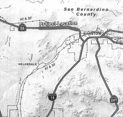 In May 2013, the CTC received
notice of a proposed EIR related to a project that would widen a portion
of Route 58 from two lanes to four lanes. The project is programmed in the
2012 State Transportation Improvement Program. The total estimated cost
for construction and support is $194,925,000. Construction is estimated to
begin in Fiscal Year 2014-15. There are four alternatives being
considered: (1) No Build Alternative. (2) Southerly Alignment (Identified
Preferred Alternative). A new alignment would diverge from the existing
alignment of Route 58 west of Valley View Road and rejoin the existing
Route 58 alignment just east of Lenwood Road. The alignment would run
approximately 0.5 mile south of the existing Route 58 alignment. (3) A new
facility would run along the existing Route 58 alignment. At the easterly
end of the project the alignment would be adjusted to avoid encroachment
on the Burlington Northern Santa Fe (BNSF) railroad tracks. (4) Northerly
Alignment. A new alignment would diverge from the existing alignment of
Route 58 east of Frontier Road and would rejoin the existing Route 58
alignment just east of Lenwood Road. The alignment would run approximately
0.5 mile north of the existing Route 58 alignment.
In May 2013, the CTC received
notice of a proposed EIR related to a project that would widen a portion
of Route 58 from two lanes to four lanes. The project is programmed in the
2012 State Transportation Improvement Program. The total estimated cost
for construction and support is $194,925,000. Construction is estimated to
begin in Fiscal Year 2014-15. There are four alternatives being
considered: (1) No Build Alternative. (2) Southerly Alignment (Identified
Preferred Alternative). A new alignment would diverge from the existing
alignment of Route 58 west of Valley View Road and rejoin the existing
Route 58 alignment just east of Lenwood Road. The alignment would run
approximately 0.5 mile south of the existing Route 58 alignment. (3) A new
facility would run along the existing Route 58 alignment. At the easterly
end of the project the alignment would be adjusted to avoid encroachment
on the Burlington Northern Santa Fe (BNSF) railroad tracks. (4) Northerly
Alignment. A new alignment would diverge from the existing alignment of
Route 58 east of Frontier Road and would rejoin the existing Route 58
alignment just east of Lenwood Road. The alignment would run approximately
0.5 mile north of the existing Route 58 alignment.
In October 2013, the CTC considered for future approval of funding a project in San Bernardino County that will widen a portion of Route 58 from two lanes to four lanes in and near the town of Hinkley. The project is programmed in the 2012 State Transportation Improvement Program. The total estimated cost is $194,925,000 for capital and support. Construction is estimated to begin in Fiscal Year 2014-15. The scope, as described for the preferred alternative, is consistent with the project scope programmed by the Commission in the 2012 State Transportation Improvement Program.
In June 2014, the CTC authorized $137,487,000 for the STIP project to widen Route 58 to 4-lanes in Hinkley, from Valley View Drive to Agate Road. The project will add 18 new lane miles and construct two overcrossings.
In August 2015, it was reported that work on the
Hinkley Bypass was progressing. The $201 million project was awarded to
Skanska USA Civil and is expected to be finished by December 2016. Crews
have already started work. The project will widen and realign Route 58
from a two-lane conventional highway to a four-lane expressway. Two
interchanges will be built at Hinkley Road and Lenwood Road. The
expressway will be extended approximately 2.89 miles west of Hidden River
Road to approximately 0.7 miles east of Lenwood Road. The expressway will
have 12-foot standard lanes, 10-foot standard shoulder widths and a
78-foot-wide median. The existing Route 58 will remain open during
construction. Hinkley and Lenwood roads are closed to traffic. However,
off-road enthusiasts are creating difficulties for construction. They are
upset about the construction because once the project is completed there
will be no means of legally crossing the expressway for off-road
enthusiasts. This blockage will extend from Barstow to Kramer Junction and
possibly beyond. Fences will be erected on both sides of the highway,
which will prevent off-roaders from crossing legally. Off-road enthusiasts
are advocating for Caltrans to add an underpass in the Hinkley area so
off-roaders can get to one side from the other. The belief is that if an
underpass is not added, some off-roaders will break the law and cut holes
in the fences.
(Source: Victor Valley Daily Press, 8/1/2015)
In November 2016, it was noted that they've recently
opened the Hinkley Rd overpass, and closed the detour via Dixie Rd, so
they can fill in the gap in the new roadbed. The Lenwood Rd overpass is
not yet paved.
(Source: pderocco @ AAroads, 11/2/2016)
In March 2017, it was reported that the Hinkley Bypass
was getting closer to opening. In preparation, Caltrans and its contractor
Skanska was shifting eastbound Route 58 traffic from the existing highway
to the new alignment on the Route 58 Hinkley Expressway. Westbound traffic
will remain on the existing highway for until early April, then will shift
to the new Route 58 Hinkley Expressway. The project began in June 2015 and
is widening and realigning the highway from two lanes to a four-lane
expressway. In addition, two interchanges on the widened and realigned
section of the highway are being built. One is at Hinkley Road, the other
at Lenwood Road.
(Source: Desert Dispatch, 3/12/2017)
In June 2020, the CTC authorized relinquishment of 16
segments of right of way, consisting of collateral facilities on
superseded portion of State Route 58 (Barstow-Bakersfield Highway) and
Realigned Route 58 from Wagner Road to Lenwood Road, in the County of San
Bernardino along Route 58 near Hinkley (08-SBd-58-PM R22.64/R30.53) under
the terms and conditions as stated in the relinquishment agreement dated
April 22, 2014.
(Source: June 2020 CTC Agenda, Agenda Item 2.3c)
The new portion of the Route 58 freeway then begins, from ½ mile east of Lenwood Road to I-15 (~ SBD R29.922 to SBD R34.687). Caltrans has begun the process of scoping out the Hinkley section of Route 58 for upgrade to 4-lane expressway and the portion surrounding Kramer Junction won't be too far behind. In 2007, funding for construction of the Hinkley 4-lane expressway ($130,400K) was requested from the Corridor Mobility Improvement Account (CMIA), but the project was non-recommended.
In August 2015, the CTC authorized relinquishment of 08-SBd-58-PM R33.4, 08-SBd-15-PM 71.5/72.0: Relinquishes right of way in the city of Barstow along Route 15 on Main Street (formerly Route 31, formerly Route 66) and at “L” Street, consisting of superseded highway and collateral facilities. There's a little bit of Route 58 in there as well, near Main Street. The City, by freeway agreement dated November 19, 1990, agreed to accept title upon relinquishment by the State, and by Resolution No. 4868-2017, agreed to waive the 90-day requirement and accept the relinquishment.
Near Barstow, the new Route 58 interchange has been completed (~ 058 SBD R34.653, ~ 015 SBD 69.949), and the old interchange is now signed as plain old "Old Highway 58"—no shield, no nothing (~ 015 SBD 75.031). The old routing was up for relinquishment in April 2004. According to Joe Rouse, the original plan was to build a freeway tying in with the then-existing highway just west of Barstow (about ¾ mile E of where Community Blvd ends at Old Hwy 58). A large interchange and short freeway spur was built on I-15 as part of that. This spur ended at Main Street and the interchange was signed as such. When the new Route 58 freeway was completed southwest of Barstow, this interchange was removed and replaced with an extension of L Street and a new diamond interchange.
The April 2005 CTC agenda showed a resolution to relinquish right of way in the City of Barstow, between Irwin Road and I-15, consisting of superseded highway right of way.
Naming The interchange at Route 99 and eastbound Route 58 in the County of Kern (~
KER R52.591) is named the "CHP Officer Gerald N. Harris Memorial
Interchange". It was named in memory of Officer Gerald Nathan
Harris, who was born in 1938 in the City of Bakersfield, California.
Officer Harris graduated from North High School in 1957, and enlisted in
the United States Marine Corps shortly thereafter. After several years of
service, he was honorably discharged on December 5, 1965. Officer Harris
was a service salesman employed by Three Way Chevrolet prior to becoming a
California Highway Patrol Officer. Officer Harris graduated from the
Department of the California Highway Patrol Academy in 1967 with Academy
Class CTC-IV-67, and was assigned to the Santa Fe Springs Area, where he
served for approximately one year before being transferred to the
Bakersfield Area, where he spent the remainder of his career. Officer
Harris, badge number 5554, was killed in the line of duty on February 27,
1974, while directing traffic at an intersection in the City of
Bakersfield, where he was struck by a hit-and-run driver. The impact of
the collision left Officer Harris with a broken leg and other injuries,
which, at the time, did not appear to be life threatening. When Officer
Harris subsequently required special medical treatment, the president of
Continental Telephone in the City of Bakersfield volunteered his
company’s medical plane to take him to a hospital in San Francisco
for special treatment, but Officer Harris, unfortunately, died shortly
thereafter from an embolism. Officer Harris was a hardworking, dedicated
officer who loved his job and enjoyed the people with whom he worked, and
who, throughout his career, received several letters commending him on his
exemplary service, including one from then Wasco Chief of Police, Robert
Duke, and several thank you letters from those whose lives he saved or
changed dramatically. Officer Harris was good natured, gracious, honest
and loyal, and would always go out of his way to help those in need. In
his spare time, he enjoyed weight lifting, the Police Olympics, softball,
volunteering to teach bicycle safety to children in schools, and spending
time with his family and friends. Named by Senate Concurrent Resolution
119, Resolution Chapter 131, August 28, 2014.
The interchange at Route 99 and eastbound Route 58 in the County of Kern (~
KER R52.591) is named the "CHP Officer Gerald N. Harris Memorial
Interchange". It was named in memory of Officer Gerald Nathan
Harris, who was born in 1938 in the City of Bakersfield, California.
Officer Harris graduated from North High School in 1957, and enlisted in
the United States Marine Corps shortly thereafter. After several years of
service, he was honorably discharged on December 5, 1965. Officer Harris
was a service salesman employed by Three Way Chevrolet prior to becoming a
California Highway Patrol Officer. Officer Harris graduated from the
Department of the California Highway Patrol Academy in 1967 with Academy
Class CTC-IV-67, and was assigned to the Santa Fe Springs Area, where he
served for approximately one year before being transferred to the
Bakersfield Area, where he spent the remainder of his career. Officer
Harris, badge number 5554, was killed in the line of duty on February 27,
1974, while directing traffic at an intersection in the City of
Bakersfield, where he was struck by a hit-and-run driver. The impact of
the collision left Officer Harris with a broken leg and other injuries,
which, at the time, did not appear to be life threatening. When Officer
Harris subsequently required special medical treatment, the president of
Continental Telephone in the City of Bakersfield volunteered his
company’s medical plane to take him to a hospital in San Francisco
for special treatment, but Officer Harris, unfortunately, died shortly
thereafter from an embolism. Officer Harris was a hardworking, dedicated
officer who loved his job and enjoyed the people with whom he worked, and
who, throughout his career, received several letters commending him on his
exemplary service, including one from then Wasco Chief of Police, Robert
Duke, and several thank you letters from those whose lives he saved or
changed dramatically. Officer Harris was good natured, gracious, honest
and loyal, and would always go out of his way to help those in need. In
his spare time, he enjoyed weight lifting, the Police Olympics, softball,
volunteering to teach bicycle safety to children in schools, and spending
time with his family and friends. Named by Senate Concurrent Resolution
119, Resolution Chapter 131, August 28, 2014.
(Image source: Scoopnet; Calif. Assn. of Highway Patrolmen)
 The segment of this route between Rout 99 and Route 184 (~ KER R52.591 to KER R59.396) is named the "Rosa
Parks Highway". This highway was named to honor Rosa Parks on her 89th
birthday. Rosa Parks was born on February 4, 1913, in Tuskegee, Alabama.
On December 1, 1955, she was arrested in Montgomery, Alabama for refusing
to give up her seat on a bus to a white man. This will for equal rights
was considered the start of the equal rights movements, and was the
impetus for a boycott of Montgomery buses, led by Dr. Martin Luther King,
Jr., by approximately 42,000 African-Americans for 381 days. This boycott
let to the United States Supreme Court ruling that Montgomery's
segregation law was unconstitutional on November 13, 1956; on December 20,
1956, Montgomery officials were ordered to desegregate buses. As a result
of this event, Rosa Parks has been considered to be the "Mother of the
Modern Day Civil Rights Movement". Her courage and conviction laid the
foundation for equal rights for all Americans and for the Civil Rights Act
of 1964. She was also the first woman to join the Montgomery chapter of
the NAACP, and was an active volunteer for the Montgomery Voters League.
She cofounded the Rosa and Raymond Parks Institute for Self Development in
1987 to motivate and direct youth to achieve their highest potential
through the "Pathways to Freedom" program. She is the recipient of many
awards including the Presidential Medal of Freedom, the Congressional Gold
Medal of Honor, and the first International Freedom Conductor Award from
the National Underground Railroad Freedom Center. Named by Assembly
Concurrent Resolution 134, Chapter 110, on August 15, 2002.
The segment of this route between Rout 99 and Route 184 (~ KER R52.591 to KER R59.396) is named the "Rosa
Parks Highway". This highway was named to honor Rosa Parks on her 89th
birthday. Rosa Parks was born on February 4, 1913, in Tuskegee, Alabama.
On December 1, 1955, she was arrested in Montgomery, Alabama for refusing
to give up her seat on a bus to a white man. This will for equal rights
was considered the start of the equal rights movements, and was the
impetus for a boycott of Montgomery buses, led by Dr. Martin Luther King,
Jr., by approximately 42,000 African-Americans for 381 days. This boycott
let to the United States Supreme Court ruling that Montgomery's
segregation law was unconstitutional on November 13, 1956; on December 20,
1956, Montgomery officials were ordered to desegregate buses. As a result
of this event, Rosa Parks has been considered to be the "Mother of the
Modern Day Civil Rights Movement". Her courage and conviction laid the
foundation for equal rights for all Americans and for the Civil Rights Act
of 1964. She was also the first woman to join the Montgomery chapter of
the NAACP, and was an active volunteer for the Montgomery Voters League.
She cofounded the Rosa and Raymond Parks Institute for Self Development in
1987 to motivate and direct youth to achieve their highest potential
through the "Pathways to Freedom" program. She is the recipient of many
awards including the Presidential Medal of Freedom, the Congressional Gold
Medal of Honor, and the first International Freedom Conductor Award from
the National Underground Railroad Freedom Center. Named by Assembly
Concurrent Resolution 134, Chapter 110, on August 15, 2002.
(Image source: The Negro Woman in History Blog)
 The segment of this route between Route 184 and the Kern County/San Bernardino
county line (~ KER R59.396 to KER R143.832) is named the Kern County
Korean War Veterans Memorial Highway. It was named in honor of the
Veterans of the Korean War from Kern County. From June 25, 1950, until
July 27, 1953, the United States was involved in a bloody conflict with
North Korea and China following the North Korean invasion of South Korea.
Of the 1,789,000 Americans that served in Korea for the purpose of
preventing the Communist takeover of South Korea, 36,516 Americans died,
103,284 were wounded, 7,245 were prisoners of war, and 8,176 are still
unaccounted for. There were 42 Kern County military personnel killed in
action in Korea, three died while missing, two died while captured, and
six died from wounds, and approximately 8,120 Korean War veterans lived in
Kern County as of 2004. In 2004, thirty-six Korean veterans organized as
the Korean War Veterans Association (KWVA), Charles N. Bikakis Chapter,
P.O. Box 10133, Bakersfield, CA 93389-0133. Named by Assembly Concurrent
Resolution 209, Chapter 194, September 16, 2004.
The segment of this route between Route 184 and the Kern County/San Bernardino
county line (~ KER R59.396 to KER R143.832) is named the Kern County
Korean War Veterans Memorial Highway. It was named in honor of the
Veterans of the Korean War from Kern County. From June 25, 1950, until
July 27, 1953, the United States was involved in a bloody conflict with
North Korea and China following the North Korean invasion of South Korea.
Of the 1,789,000 Americans that served in Korea for the purpose of
preventing the Communist takeover of South Korea, 36,516 Americans died,
103,284 were wounded, 7,245 were prisoners of war, and 8,176 are still
unaccounted for. There were 42 Kern County military personnel killed in
action in Korea, three died while missing, two died while captured, and
six died from wounds, and approximately 8,120 Korean War veterans lived in
Kern County as of 2004. In 2004, thirty-six Korean veterans organized as
the Korean War Veterans Association (KWVA), Charles N. Bikakis Chapter,
P.O. Box 10133, Bakersfield, CA 93389-0133. Named by Assembly Concurrent
Resolution 209, Chapter 194, September 16, 2004.
(Image source: Flikr)
In Bakersfield, this is named the "Bakersfield-Tehachapi Highway", based on its endpoints.
 Tehachapi Pass (~ KER R94.16) is believed to derive from the name the local
Indians gave to a creek: Tah-ee-chay-pah. At least part of the word is
thought to carry the meaning of frozen. One writer theorizes “the
meaning ‘frozen’ may have been applied first to the creek,
which at some time was found to be frozen.” The pass today is very
busy on account traffic on Route 58 that links Bakersfield with Mojave.
Union Pacific and BNSF Railway share trackage rights across the
challenging grade. To keep the steepness from being too severe, surveyors
called for a loop, famous in railroad circles, that is situated about 18
miles west of the pass. The loop is almost 3/4 th of a mile around; it
gains 77 feet in elevation and requires about 85 box cars to fill the
whole of it. The rail route across the pass was built largely by 3,000
workers brought in from Canton, China. Most of the original track
was laid over a two-year span (1874-1876). The work was accomplished only
with picks, shovels, horse drawn carts and blasting powder. The loop has
been dubbed one of the “seven wonders of the railroad world.”
Tehachapi Pass (~ KER R94.16) is believed to derive from the name the local
Indians gave to a creek: Tah-ee-chay-pah. At least part of the word is
thought to carry the meaning of frozen. One writer theorizes “the
meaning ‘frozen’ may have been applied first to the creek,
which at some time was found to be frozen.” The pass today is very
busy on account traffic on Route 58 that links Bakersfield with Mojave.
Union Pacific and BNSF Railway share trackage rights across the
challenging grade. To keep the steepness from being too severe, surveyors
called for a loop, famous in railroad circles, that is situated about 18
miles west of the pass. The loop is almost 3/4 th of a mile around; it
gains 77 feet in elevation and requires about 85 box cars to fill the
whole of it. The rail route across the pass was built largely by 3,000
workers brought in from Canton, China. Most of the original track
was laid over a two-year span (1874-1876). The work was accomplished only
with picks, shovels, horse drawn carts and blasting powder. The loop has
been dubbed one of the “seven wonders of the railroad world.”
(Sources: Bill Sanford "Getting out of the Central
Valley: Highway passes to the east" (emailed draft 10/1/2010); Image
source: Sierra Mountain Passes)
 Business Routes
 Named Structures
This route also has the following Safety Roadside Rest Areas:
 Additionally, at PM SBD 18.3 in San Bernardino County, there is a memorial to CHP Officer Kenneth L.
Archer and Officer Robert G. Carey. California Highway Patrol
Officer Robert G. Carey was piloting a departmental helicopter on February
24, 1982, in response to an emergency call of a downed aircraft in the
Harper Lake area north of Route 58, when he and his fellow officer, flight
observer Kenneth L. Archer, gave their lives in the line of duty as their
helicopter crashed at Harper Lake. Named by Assembly Concurrent Resolution
174, Chapter 143, September 18, 2000.
Additionally, at PM SBD 18.3 in San Bernardino County, there is a memorial to CHP Officer Kenneth L.
Archer and Officer Robert G. Carey. California Highway Patrol
Officer Robert G. Carey was piloting a departmental helicopter on February
24, 1982, in response to an emergency call of a downed aircraft in the
Harper Lake area north of Route 58, when he and his fellow officer, flight
observer Kenneth L. Archer, gave their lives in the line of duty as their
helicopter crashed at Harper Lake. Named by Assembly Concurrent Resolution
174, Chapter 143, September 18, 2000.
(Image source: Facebook)
 National Trails
The segment of this route from Bakersfield to Route 155 was historically named the "Lions Trail".
 Scenic Route Freeway
[SHC 253.4] Entire portion. Added to the Freeway and Expressway system in 1959.
 Classified Landcaped Freeway
The following segments are designated as Classified Landscaped Freeway:
| County | Route | Starting PM | Ending PM |
| Kern | 58 | T52.22 | R55.66 |
| Kern | 58 | R55.66 | R55.71 |
| Kern | 58 | R55.71 | R56.69 |
 Exit Information Other WWW Links
 Interstate Submissions
Submitted for inclusion in the interstate system in 1956 and 1968; not accepted either time. Route 58 is constructed to freeway standards from the jct of Route 99 in Bakersfield to 19 miles east to the jct with Route 223, and begins again as freeway at a point .5 miles east of the Route 223 intersection to approximately 1 mile before Tehachapi Pass. Freeway begins again near the Edwards Air Force base for approximately 19 miles to a point east of Boron.
The question is often raised of why this has not been designated as a continuation of I-40. After all, it was submitted once -- it could be submitted again. Scott Parker addressed this in an AAroads post on 7/10/2016, which is as good an explanation as any (minor editing was done to fit the conventions of this website):
As with the Route 99 corridor, any push for Interstate status for Route 58 will have to come from political forces in the affected regions; there is little possibility that Caltrans itself would initiate such an action. Local political action was responsible for the last three [non-chargable] Interstate conversions (I-110 in '81, I-710 in '84, and I-880 in '86); in each case, a congressman from the area (the late Glenn Anderson, D-Gardena, in the case of the first two) was on point for the necessary AASHTO/FHWA vetting. Part of the problem is that the actual construction involved in Interstate upgrades is considered within Caltrans to be just another drain on their resources -- and that the budgeting process that is involved in apportioning funds to each district would be substantially disrupted by "piling on" such an outlay in addition to the requirements of the STIP under which they are operating. Unless an improvement to Interstate standards on one of the corridors in question is actually contained within the currently effective STIP, even considering 5 to 15-year windows for upgrades to any is thought of as an "off-book" project. It's not like it was with the pre-'73 Division of Highways; Caltrans is an omnibus tranportation/transit agency with as much $$ volume going to localized (mostly urban/suburban) programmed projects -- just examine any of the last three or four STIP's on a line-item level! [Ed: And if you note, the first interstate submissions for this route were prior to 1973] Long-distance corridor work, unless severely substandard facilities are involved (like Route 99 between Route 198 and the Fresno area), is undertaken if and only if there is sufficient funding available -- which, given the more recent bias toward street/transit issues in denser locales, is not always a given.
In short, Interstate conversion isn't cheap -- and Caltrans' priorities are presently focused on localized issues; they won't run point on such long-distance upgrades. If either Route 58 or Route 99 is to gain Interstate status -- despite being warranted by commercial traffic stats -- it will come from outside. Since the Route 99 corridor is already listed (via an addendum to the High Priority Corridor 54 description) as a future Interstate, the only legislative action required for signage would be for a member of Congress to pick a number and tack it onto the existing legislative description; the existence of the state plan to expand Route 99 would likely serve as a de facto "25-year-window" for facility compliance. Arranging for the same treatment for Route 58 would require an entirely new corridor designation (Barstow to Buttonwillow); the process would be similar if not identical to the language added to the yearly federal funding bill that eventually resulted in I–42 in NC. Again, that would have to come from a congressional source with sufficient clout to steer it through the committee process. In the case of either corridor, it's likely that Caltrans would approach either "mandate from above" with their usual shrug of the shoulders; they'd likely spread any upgrade projects over as many STIP terms as they could, and carry on as before, with work progressing at a marginally faster rate than before.
Scott Parker also noted more information on the history of the submission
of Route 58 as interstate:
(Source: SParker on AARoads, "Re: Westside Parkway & Centennial Corridor (CA 58 realignment, Bakersfield)", 8/20/2021)
The last time anything formal about Route 58 becoming I-40 was back in 1968, when the corridor was a part of the original 4500-mile configuration of that year's Interstate additions; submitted by DOH the previous year. Of course, when the cut-down to 1500 miles occurred, this was one of the deletions. Nothing since then, although a conversation I had with Caltrans planners back in 1987 indicated that Route 58 was about the only corridor that they would even consider submitting for such status. But Caltrans and their political handlers have had several opportunities with the various federal omnibus bills since that time (ISTEA, NHS, SAFETEA-LU, etc.) to get such a corridor concept on the books, but haven't done so to date, which seems to indicate that official enthusiasm for such an action is presently negligible. And since Route 58's currently fully a free-flow freeway/expressway for the entire length between I-15 and CA 99, it probably won't get short-term attention unless safety issues stemming from the Route 223 interchange or any of the other remaining at-grade crossings become publicly problematic, prompting "spot" fixes, including grade separations/interchanges, as needed. But the chances of an end-to-end upgrade program at this time are pretty slim.
 Blue Star Memorial Highway
This route was designated as a "Blue Star Memorial Highway" by Assembly Concurrent Resolution 203, Ch. 324 in 1969.
 Statistics
Overall statistics for Route 58:
 Interregional Route
 Pre-1964 Legislative Route
The route that became LRN 58 was first defined in the 1919 Third Bond Act as the route from Mojave to Needles via Barstow. In 1925, Chapter 279 authorized the highway commission “...to acquire necessary rights of way and to construct and maintain a highway, which shall constitute and be a state highway, extending from Needles or from a point to be selected by the California Highway Commission upon the route of the state highway extending from San Bernardino to Needles in the county of San Bernardino to a point to be selected by the California Highway Commission and the state of Arizona opposite the town of Topock, Arizona or at such other point thereon as may be selected by said California Highway Commission...”
In 1931, Chapter 82 authorized extension of the route from Bakersfield to Mojave, with the state taking jurisdiction over a former county route. In 1933, the route was extended further, from [LRN 2] near Santa Margarita to [LRN 4] near Bakersfield. By 1935, the route was codified in the highway code as follows:
[LRN 2] near Santa Margarita to the Arizona State Line near Topock Arizona via Bakersfield, Mojave, Barstow, and Needles
Later in 1935, it was amended by Chapter 513 to add the following, "together with an extension from a point on such [LRN 58] near Needles easterly by the most direct and practicable route to the Arizona-California line at the Colorado River, including a bridge over and across said river to be constructed, owned, operated, and maintained jointly with the state of Arizona". This definition remained until the renumbering in 1963.
The route was signed as Route 178 between US 101 (LRN 2) and Bakersfield, as US 466 between Bakersfield and Barstow, and as US 66 between Barstow and the Arizona border. After 1964, this routing was signed as Route 58 between Santa Margarita (US 101) and Barstow. Between Barstow and the Arizona line, portions were the unsigned National Trails Highway ("old US 66"), and portions were I-40. It should be noted that this is one of the few routes where the pre-1963 legislative route number was the post 1963 signed route number.
© 1996-2020 Daniel P. Faigin.
Maintained by: Daniel P. Faigin
<webmaster@cahighways.org>.
 Route 57
 Route 59