
 California Highways:
Click here for a key to the symbols used. An explanation of acronyms may be found at the bottom of the page.
 Routing
No current routing.
 Post 1964 Signage History
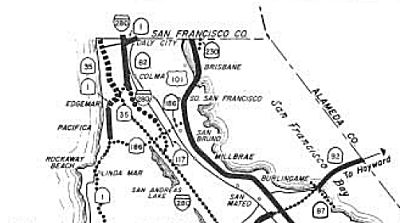
1963 - 1965 Routing (SF Bay Area)
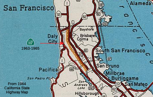 In 1963, Route 117 was defined as the route ran
from "Crystal Springs Road in the City of San Bruno northerly to Route 280
in Daly City." Its definition also noted that " Joint Highway District No.
10 is dissolved in accordance with the provisions of Chapter 20 of Part 1
of Division 16 of the Streets and Highways Code, and all property, assets,
and liabilities of said district are the property of the State."
In 1963, Route 117 was defined as the route ran
from "Crystal Springs Road in the City of San Bruno northerly to Route 280
in Daly City." Its definition also noted that " Joint Highway District No.
10 is dissolved in accordance with the provisions of Chapter 20 of Part 1
of Division 16 of the Streets and Highways Code, and all property, assets,
and liabilities of said district are the property of the State."
In 1965, that definition of Route 117 was deleted by Chapter 1372. This included the portion of Junipero Serra Boulevard south of Serramonte Boulevard, which did not have the parallel I-280 until the early 1970s. This segment is built to expressway standards, complete with CalTrans green signs at intersections, jersey barriers, and even a CalTrans maintenance station at Junipero Serra and Westborough. This may also have been what is the current routing of I-280, as in 1967 some maps show Route 280 as continuing along Skyline to Sneath in San Bruno before cutting up to S San Francisco and Daly City.
Junipero Serra Boulevard north of San Bruno was transferred legislatively
as Route 280, which functioned as a placeholder connection for
I-280. This was shown on the 1966 Division of Highways Map.
Junipero Serra Boulevard was relinquished from the State Highway System
during 1970 following the completion of I-280 on the Junipero Serra
Freeway north of San Bruno.
(Source: Gribblenation Blog (Tom Fearer), "California State Route 117 (i)", 12/20/2023)
A document on the Millbrae Spur Property noted that:
In early 1955 the proposed route of the Junipero Serra Highway was reoriented in San Bruno to go to Skyline Boulevard and south to Ralston Avenue in Belmont. This new route was located considerable west of the original route; it no longer divided the Peninsula cities. In the 1960s the route was again modified, and the proposed Junipero Serra Highway was absorbed into the Interstate Highway System, which created I-280 connecting San Francisco and San Jose.
Chris Sampang has surmised this might confirm that former Route 117 is
leftover right of way. Scott Parker (SParker) confirmed that on AAroads, noting:
(Source: Scott Parker on AARoads, "Re: junipero serra over / under in Daly City", 1/5/2019)
As I-280 functionally supplanted that section of Junipero Serra Blvd., it was likely that the present configuration was made to enhance the local business prospects of the immediate area; it moved from side to side to connect existing commercial facilities. FYI, the original supplanted segment of Serra was the original (1964) Route 117; that designation was deleted ca. 1970 after I-280 was opened to traffic.
 ChrisSampang
noted that at Seton Hospital there is an overhead picture of Daly City
from 1955 that shows two grade separations on the Junipero Serra Boulevard
corridor (Route 117), which correspond to current exits on the Serra
Freeway: Alemany Boulevard/John Daly Boulevard and Washington Street.
There are some intriguing difference.
ChrisSampang
noted that at Seton Hospital there is an overhead picture of Daly City
from 1955 that shows two grade separations on the Junipero Serra Boulevard
corridor (Route 117), which correspond to current exits on the Serra
Freeway: Alemany Boulevard/John Daly Boulevard and Washington Street.
There are some intriguing difference.
1972 - 1986 Routing (San Diego Area)
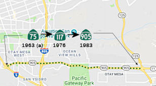 In 1972, Chapter 1216 recreated Route 117 as "the
international boundary near Borderfield northeasterly to Route 5."
In 1972, Chapter 1216 recreated Route 117 as "the
international boundary near Borderfield northeasterly to Route 5."
In 1976, Chapter 1354 changed "Borderfield" to "Border Field" and added "(b) Route 5 near the south end of San Diego Bay to Route 125 near Brown Field." This was a transfer from Route 75.
In 1986, Chapter 929 renumbered Route 117 as (non-chargable interstate) Route 905.
 Pre 1964 Signage History
1963 - 1965 Routing (SF Bay Area)
The 1964-1965 routing was LRN 237 (defined in 1956), but was never constructed or signed. LRN 237 was defined as "Junipero Serra Boulevard as it exists and as it was constructed by Joint Highway District № 10 from its junction with LRN 56 (Route 1) in Daly City to the present terminus of said highway in the City of San Bruno. Upon the effective date of this section, the Joint Highway District № 10 shall be dissolved in accordance with the provisions of Chapter 20 of Part 1 of Division 16 of the Streets and Highway Code and all property, assets, and liabilities of said district shall become property of the State."
Joint Highway District № 10 was created during 1928 as a
cooperative between San Francisco County and San Mateo County. The
purpose of the district was to ultimately construct a new arterial highway
from San Franscico south to San Jose. By 1939 the district had
located an alignment for Junipero Serra Boulevard as far south as Santa
Clara County line. Junipero Serra Boulevard had constructed to
Crystal Springs Road by 1952 via right-of-way largely obtained in
Millbrae. Joint Highway District № 10 began to encounter
financial difficulties and issues finding a suitable alignment; this led
to Junipero Serra Boulevard being turned over to the state as LRN 237
during 1956. The general routing of the Junipero Serra Freeway
(I-280) following LRN 237/existing Junipero Serra Boulevard north of San
Bruno was adopted by the California Highway Commission during 1960.
(Source: Gribblenation Blog (Tom Fearer), "California State Route 117 (i)", 12/20/2023)
In 1958, the CHC adopted the planned Junipero Serra Freeway from the end
of Junipero Serra Boulevard/LRN 237 near San Bruno Avenue to Saratoga
Avenue in Santa Clara. The prospective relocation of LRN 237 onto an
adopted freeway corridor was under study. By 1960, the southern terminus
of LRN 237 was connected to the adopted Junipero Serra Freeway corridor of
LRN 239.
(Source: Gribblenation Blog (Tom Fearer), "California State Route 117 (i)", 12/20/2023)
1972 - 1986 Routing (San Diego Area)
The post-1972 routing was new, although the portion added from Route 75 was approximately LRN 281, although its proposed routing was slighly N of the current Route 905.
Sign Route 117 was not defined as part of the initial state signage of routes in 1934. It is unclear what (if any) route was signed as Sign Route 117 between 1934 and 1964.
 Other WWW Links
 Pre-1964 Legislative Route
In 1933, Chapter 767 added the route from "Monterey to [LRN 2] near Salinas" to the highway system. In 1935, this was codified as LRN 117 in the highway code with that definition, which remained unchanged until the 1963 renumbering. The route ran from Monterey to US 101 near Salinas, and is present-day Route 68.
Tom Fearer investigated the history of LRN 117, and noted the following:
(Source: Gribblenation Blog (Tom Fearer), "California State Route 68")
© 1996-2020 Daniel P. Faigin.
Maintained by: Daniel P. Faigin
<webmaster@cahighways.org>.
 Route 116
 Route 118