
 California Highways:
Click here for a key to the symbols used. An explanation of acronyms may be found at the bottom of the page.
 Routing
 Post 1964 Signage History
This route is as defined in 1963.
 Pre 1964 Signage History
This was part of a 1959 extension of LRN 210. It was not signed before 1963.
Route 161 was not defined as part of the initial state signage of routes in 1934. It is unclear what (if any) route was signed as Route 161 between 1934 and 1964.
Note: The following is summarized from Gribblenation Blog (Tom Fearer), “California State Route 161”, September 2021. See the blog post for more details, history, links to maps, and other artifacts and correspondence. Excerpted with permission.
The history of Route 161 is tied heavily to that of the Klamath
Reclamation Project within the Klamath Basin. In 1905 the Federal
Government announced it would fund the Klamath Reclamation Project which
would drain much of the Klamath Basin for agricultural use. The A
Canal was constructed during 1906 and began delivering diversions from the
Klamath River and Upper Klamath Lake in 1907. The Southern Pacific
Railroad plotted a line through the Klamath Basin in 1909 connecting many
of the existing communities such as Klamath Falls and Merill. In
1910 Clear Lake Dam was completed that was followed by the Lost River
Division Dam in 1912. Anderson-Rose Dam and the Link River dam was
completed by 1921, followed by the Malone Division Dam on the Lost River
in 1923. By 1944, Route 139 was established east of Tulelake, connecting
Klamath Falls with Susanville, but there still was not an east/west
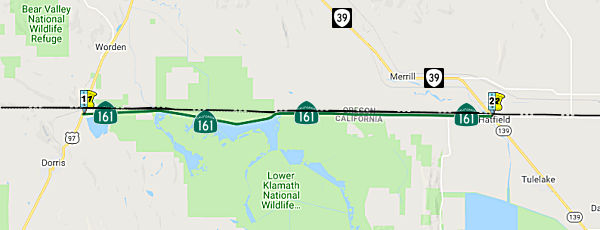
highway connecting the area to Dorris at US 97/LRN 72. The State
Line Highway between Tulelake and Dorris was mostly constructed in 1948
via funding of a 15.4 mile Federal Aid Secondary program, and was a
Siskiyou County maintained roadway. By 1956, State Line Highway was
completed east of Malone Road to Riyte 139/LRN 210. In 1959, LRN 210 had a
second segment added between Hatfield (immediately north of Tulelake) on
the Oregon/California State Line west to US 97/LRN 72 near Dorris. Much of
State Line Highway was rebuilt west of Hatfield in 1958 including a new
bridge over the Lost River. State Line Highway was accepted for
Division of Highways maintenance after meeting state standards on November
1st, 1959.
(Source: Gribblenation Blog (Tom Fearer), “California State Route 161”, September 2021)
 Naming
 Freeway
[SHC 253.1] Entire route. Added to the Freeway and Expressway system in 1959.
 Scenic Route
[SHC 263.1] Entire route.
 National Trails
![[Volcanic Byways]](logos/volcanic.jpg) This route is part of the Volcanic Legacy Scenic Byway All American Road.
This route is part of the Volcanic Legacy Scenic Byway All American Road.
 Other WWW Links
 Statistics
Overall statistics for Route 161:
 Pre-1964 Legislative Route
In 1933, Chapter 767 defined the routes from "[LRN 2] near Cahuenga Park to [LRN 4] near Burbank" and from "[LRN 4] near Glendale to [LRN 9] near Monrovia" as part of the state highway system. In 1935, LRN 161 was added to the highway code with the following routing:
In 1947 (1st ex. sess.), Chapter 11 added an additional segment and clarified the routing:
In 1957, Chapter 1911 reversed the order and changed (b): “[LRN 4]
near Glendale to [LRN 2] near Riverside Drive Vineland
Avenue”
This route was signed as follows:
This was a segment of US 99.
This is the remainder of the Ventura Freeway, Route 134, between I-5 and US 101. Before the construction of Route 134, this ran N from US 101 (Ventura Blvd) along Fulton to Moorpark, along Moorpark to Alameda, and along Alameda to San Fernando Road. This avoided Griffith Park.
This is the older surface street routing of Route 134 from San Fernando Road to Foothill Blvd along Colorado Blvd and Colorado Street. Between 1964 and 1992, it was Route 248. The LRN was also applied to the freeway routing of Route 134 between the present-day Route 710/I-210 junction and US 99 (present-day I-5). Some of this was signed as Alternate US 66. Sparker at AAroads noted that Alternate US 66 ran along Colorado Blvd west of Fair Oaks Ave (where LRN 9 turned north and NW along Sign Route 118) west to Figueroa St., where Alternate US 66 (along with Sign Route 11, which joined Alt. US 66 from Linda Vista Ave. south of the Rose Bowl) turned south (the whole of Sign Route 11 was LRN 165). LRN 161 continued west through Glendale and Burbank, signed as Route 134, originally terminating at US 101/LRN 2 in Sherman Oaks but cut back to Lankershim Blvd. (LRN 159) in North Hollywood circa 1957. The purpose of the 2nd section of LRN 161 was simply to straighten out the alignment of US 66 in the Pasadena/Arcadia area.
© 1996-2020 Daniel P. Faigin.
Maintained by: Daniel P. Faigin
<webmaster@cahighways.org>.
 From Route
  Route 160
 Route 162