
 California Highways:
Click here for a key to the symbols used. An explanation of acronyms may be found at the bottom of the page.
 Routing
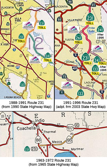 No Current Routing.
 Post 1964 Signage History
 In 1963, Route 231 was defined as "Route 86 to Route 195 near Mecca
via Avenue 66."
In 1972, Chapter 1216 deleted that routing.

 During 1986, the Transportation Corridors Agencies (TCA) of Orange County were created. Corridors
governed by the TCA included: the Eastern Transportation Corridor,
Foothill Transportation Corridor and San Joaquin Hills Transportation
Corridor. 1987 Legislative Chapter 1413 allowed for transportation
corridors to be constructed by way of toll funds. The Eastern
Transportation Corridor was assigned as Route 231, and was originally
defined as "Route 5 near the border of the Cities of Tustin and Irvine to
Route 91." At this point, the TCA routes were Route 231 (I-5 near
Tustin/Irvine to Route 91 roughly along Jamboree Road) and Route 241 (I-5
near San Clemente to Route 231 near Santiago Canyon Road (County Sign Route S18) near
Irvine Lake). Route 133 was not part of the TCA system.
During 1986, the Transportation Corridors Agencies (TCA) of Orange County were created. Corridors
governed by the TCA included: the Eastern Transportation Corridor,
Foothill Transportation Corridor and San Joaquin Hills Transportation
Corridor. 1987 Legislative Chapter 1413 allowed for transportation
corridors to be constructed by way of toll funds. The Eastern
Transportation Corridor was assigned as Route 231, and was originally
defined as "Route 5 near the border of the Cities of Tustin and Irvine to
Route 91." At this point, the TCA routes were Route 231 (I-5 near
Tustin/Irvine to Route 91 roughly along Jamboree Road) and Route 241 (I-5
near San Clemente to Route 231 near Santiago Canyon Road (County Sign Route S18) near
Irvine Lake). Route 133 was not part of the TCA system.
 In 1988, Chapter 1364 created a new definition of Route 231 as: "Route 5 near the border of the Cities of Tustin and Irvine
to Route 91."
In 1988, Chapter 1364 created a new definition of Route 231 as: "Route 5 near the border of the Cities of Tustin and Irvine
to Route 91."
In 1991, Route 133 was brought into the TCA system,
bringing changes to the route definitions. SB 732, Chapter 775 created a
new definition of Route 261 as “Route 5 near the border of the
Cities of Tustin and Irvine to Route 231”, using a routing
transferred from former Route 231. Chapter 775 extended Route 231 to the
end of Route 133 by a combination of a transfer from Route 241 (Route 261
to Route 241) and creation of a new highway from Route 241 to Route 133:
"Route 5 near the border of the Cities of Tustin and Irvine
at Route 133 to ...". Route 241 was silently truncated to run from
the Route 231/Route 241 junction near Bee Canyon and Limestone Canyon Park
to I-5. The legislative definition of Route 241 didn't need to change, as
the western end remained Route 231.
In 1996, Chapter 1154 deleted the routing and completed the incorporation of Route 133. The portion of Route 231 from Route 133 to Route 241 was transferred to Route 133. The portion from Route 241 to Route 91 was transferred to Route 241, making Route 241 run from Route 133 to Route 91. This route is one of the toll roads that form the Orange County Transportation Corridors (now Route 133, Route 261, and Route 241).
 Pre 1964 Signage History
The 1964-1972 routing for Route 231 was part of LRN 204, defined in 1935. It first appeared on the 1936-37 Division of Highways Map aligned between US 99 and Route 111.
The 1988-1996 routing of Route 231 was not part of the state highway system in 1963.
 Other WWW Links
1988-1996 Routing
1964-1972 Routing
 Naming
 Status
Overall statistics for former Route 231:
 Pre-1964 Legislative Route
 In 1949, Chapter 1261 defined LRN 231 as:
“[LRN 165] in San Pedro to [LRN 167] in Long Beach, via the mainland portion of Long Beach Outer Harbor and Terminal Island, subject to the following conditions:
1. Except as provided in paragraph number 2, no expenditure shall be made from state highway funds for the acquisition of rights of way for or construction, improvement, or maintenance of said highway until the following conditions have been met:
(a) The Federal Government shall have made available all funds necessary for the construction of said route, other than funds provided under paragraph 2.
(b) The Federal Government and the Cities of Los Angeles and Long Beach shall have granted a sufficient and adequate right of way without cost to the State of California for that portion of said route traversing lands owned or controlled by each of them.
(c) The authorized representatives of the Cities of Los Angeles and Long Beach and the appropriate agency of the Federal Government shall have approved the proposed alignment and the proposed location of all major structures on the route submitted by the State Department of Public Works.
2. Any city or county may contribute to, and the California Highway Commission may allocate monies from the State Highway Fund for the improvement of portions of [LRN 231] on the mainland when such improvement is found necessary to complete and integrated system of freeways between San Pedro, Long Beach, and the Civic Center in the City of Los Angeles.
3. If funds from sources other than state highway funds have not been made available for the construction on all portions of said [LRN 231] that are not on the mainland prior to January 15, 1953, said [LRN 231] shall on that date cease to be a state highway and this section shall have no further force or effect. ”
LRN 231 does not show on any pre-1963 state highway maps, although the routing is shown in the May/June issue of CHPW (see the page on Route 103). The non-state funding never came through, and LRN 231 was removed from the system in 1953.
© 1996-2020 Daniel P. Faigin.
Maintained by: Daniel P. Faigin
<webmaster@cahighways.org>.
 Route 230
 Route 232