
 California Highways:
Click here for a key to the symbols used. An explanation of acronyms may be found at the bottom of the page.
 Routing
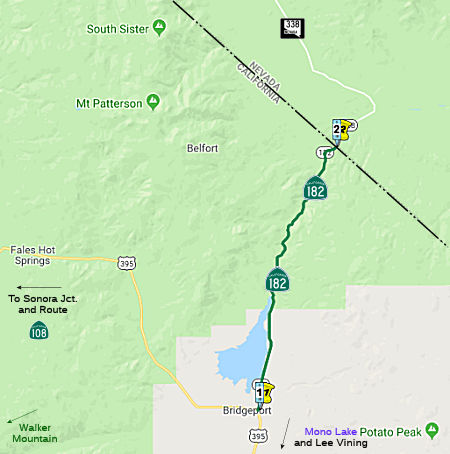 From Route 395 near Bridgeport to the Nevada state line via Walker River.
 Post 1964 Signage History
This route is as defined in 1963.
 Pre 1964 Signage History
This route was LRN 96, defined in 1933. It appears not to have been signed before 1964.It followed the Sweetwater Road from Bridgeport to Nevada.
The corridor of LRN 96 and modern Route 182 is tied to the formation of
Bridgeport. The first documented European expedition of Bridgeport
Valley was in 1827 via an expedition led by Jedediah Smith. The
prospects of the Bodie Mining District led to the establishment of
Bridgeport in Bridgeport Valley. Mono County was created by the
California Legislature during 1861 with Aurora being selected as the
original County Seat. The 1863 Sage Brush Survey determined Aurora
laid within the boundaries of Nevada which invalidated its Mono County
Seat status. Bridgeport was selected as the new Mono County Seat in
1864. Bridgeport was located on the Sweetwater Road connecting the
Bodie Mining District north via the East Walker River to the Wellington
Toll Road. The Sweetwater Stage Road was constructed by Mono County
residents during 1873. The only significant change to the Sweetwater
Stage Road prior to being adopted as LRN 96 was in 1923 when the first
five miles north of Bridgeport were relocated to less flood prone grounds
during construction of the Bridgeport Reservoir. A survey to
modernize LRN 96 to the standards set by NV 22 was also conducted.
The Bridgeport Reservoir had additional regulations put in place that
would allow LRN 96 to be straightened through old overflow flats. In
1956, aan 8.2 mile segment of the highway was reconstructed as part of FAS
580. The straightening of LRN 96 brought the highway up to modern
standards and saved 20 minutes of travel in the Bridgeport-Yerington
corridor. A second phase of the project included surfacing the
rebuilt 8.2 miles of LRN 96. During the 1976 Nevada State
Highway Renumbering NV 22 was renumbered to NV 338, which served as a
continuation of Route 182.
(Source: Gribblenation Blog (Tom Fearer), “California State Route 182 and the Sweetwater Road”, 11/2021)
Route 182 was not defined as part of the initial state signage of routes in 1934. It is unclear what (if any) route was signed as Route 182 between 1934 and 1964.
 Status
In August 2002, the CTC considered a proposal to relinquish the segment from PM MNO 0.8 to MNO PM 1.5.
 Other WWW Links
 Statistics
Overall statistics for Route 182:
 Pre-1964 Legislative Route
LRN 182 was defined in 1933 (and captured into the highway code in 1935) as:
“from [LRN 2] near Orange to Orange County Park.”
The routing ran along Chapman from Main Street to Orange County Park. In 1957, Chapter 1911 amended the definition to begin at "[LRN 43] near Orange", and it had this definition until 1963, when it was included as part of Route 22. This segment was deleted from Route 22 in 1965 and is no longer part of the state highway system. It ran along Chapman Avenue. It appears to be present-day Orange County Sign Route S25.
© 1996-2020 Daniel P. Faigin.
Maintained by: Daniel P. Faigin
<webmaster@cahighways.org>.
 Route 181
 Route 183