
 California Highways:
Click here for a key to the symbols used. An explanation of acronyms may be found at the bottom of the page.
 Routing
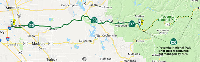 From Route 5 near Mossdale to the west boundary of Yosemite National Park via
the vicinity of Manteca and Oakdale, and via Big Oak Flat and Buck
Meadows.
From Route 5 near Mossdale to the west boundary of Yosemite National Park via
the vicinity of Manteca and Oakdale, and via Big Oak Flat and Buck
Meadows.
 Post 1964 Signage History
This segment is unchanged from its 1963 definition. There is a adopted but unconstructed 20 mile portion from Route 99 to Oakdale that is parallel to the existing traversable route.
Route 120 Bypass
 In 1967, the bypass process started when the CHC considered adoption of a freeway
routing for 21.1 mi of Route 120 between Route 99 E of Manteca and Atlas
Road, E of Oakdale. The recommended routing runs E from Route 99 about 1
mi S of Yosemite Avenue (existing Route 120), turning slightly NE about 1
mi W of Oakdale Valley Home Highway to cross Jackson Avenue (the existing
highway in and E of Escalon) just N of River Road. It then turns SE to
cross the Stanislaus River and the NE tip of Oakdale, and curves E again
to rejoin the Route 108/Route 120 expressway at Atlas Road. It was noted
that the Manteca Bypass was 2nd on the county's priority list.
In 1967, the bypass process started when the CHC considered adoption of a freeway
routing for 21.1 mi of Route 120 between Route 99 E of Manteca and Atlas
Road, E of Oakdale. The recommended routing runs E from Route 99 about 1
mi S of Yosemite Avenue (existing Route 120), turning slightly NE about 1
mi W of Oakdale Valley Home Highway to cross Jackson Avenue (the existing
highway in and E of Escalon) just N of River Road. It then turns SE to
cross the Stanislaus River and the NE tip of Oakdale, and curves E again
to rejoin the Route 108/Route 120 expressway at Atlas Road. It was noted
that the Manteca Bypass was 2nd on the county's priority list.
(Source: Stockton Evening and Sunday Record, 7/24/1967, via Joel
Windmiller, 2/16/2023)
The Route 120 bypass dates back to 1976, when state
funding for the construction was approved by the CTC. An article in the Manteca/Ripon Bulletin explored the history. It notes that, originally, both Caltrans head Adriana Gianturcco and the CTC were against
the route. What turned the tide was persistent grassroots pressure
including blanket distribution of information to travelers caught in
hellacious Manteca traffic jams on Fridays and Sundays and an aggressive
effort to enlist the support of media outlets in the influential Bay Area.
Additionally, Jack Snyder — the Manteca councilman who had taken the
point in the community effort to end the five-mile plus long traffic jams
that paralyzed Manteca from Bay Area residents going to and from the
Sierra — worked with Gov. Jerry Brown to convince him to support the
routing. Although businesses were originally against it, it turned out to
be the catalyst for economic development in Manteca. It was responsible
for getting outside residents to spend money in Manteca from retail to
hotel rooms thanks to venues such as Big League Dreams and Bass Pro Shops
that have highly visible freeway locations with easy access. The Route 120
Bypass also played a key role in Manteca snagging Great Wolf
Resorts’ attention and their proposal to invest up to $200 million
in what could ultimately be a 600-room hotel, 70,000-square-foot indoor
water park, and 60,000-square-foot conference center. The 120 Bypass was
built with ample room for expansion and widening of bridges across the
freeway.
(Source: Manteca/Ripon Bulletin, 12/31/2010)
The Caltrans design for the original bypass was a route
that alternated over a five-mile stretch from four lanes to three lanes to
two lanes and back to three lanes. The result was deadly head-on crashes
from unsafe passing maneuvers that quickly earned the Manteca 120 Bypass
the dubious title of “Blood Alley.” During a period of several
months, the bypass was averaging a fatality a week. The death toll in 18
months reached 32. Local leaders lobbied the state extensively to secure
barriers down the center of the bypass to separate traffic and virtually
eliminate head-on collisions.
(Source: Manteca/Ripon Bulletin, 7/25/2020)
Scott Parker (Sparker) on AAroads noted: When the
alignment opened to traffic in spring 1980, it was configured as a "super
two" with a few overpasses and a couple of interchanges. The overpasses
were quite short, consisting of a single span over the roadway, which was
a single lane in each direction with a double-yellow line down the center
(this preceded the later prevalence of K-rails). The scaling down of Route 120 was one of the actions taken by Caltrans under Adriana Gianturco, who
openly preferred to provide as few amenities to the driving public as
possible to discourage private automobile usage. In the mid-1980's, after
Gianturco was out of office, the existing single carriageway was widened
to provide an alternating passing lane to accommodate the high volume of
truck traffic on that facility. When the decision was made to expand the
highway to a full 2+2 freeway, the crossing single-span overpasses had to
be razed because there wasn't room to place twin carriageways through
them; they were replaced with conventional CA-standard overpasses with a
supporting bent in the median. The very wide 3-lane carriageway that
preceded the freeway upgrade can still be seen today as an extra-wide
inner shoulder on the EB lanes of the current freeway.
(Source: Scott Parker (Sparker) on AAroads, "Re: CA 120 Freeway; a legacy of US 99W, US 48 and US 50", 3/7/2019)
A 1992 San Joaquin county planning document noted that
Route 120 was primarily a two-lane facility, portions of which were a
freeway and portions of which were a conventional highway. The Western
segment between I-5 and Route 99, had the greatest traffic volumes,
ranging from 18,000 to 24,500 in 1987. Traffic conditions, at that time,
were at a level "F" level of service. In July 1992, the three "priority"
projects identified in the Council of Governments (COG) Regional
Transportation Improvement Plan (RTIP) included the following:
(Source: San Joaquin COG Community Development Plan, Volume III, Chapter II.C (Transportation), June 1992)
It noted that the Manteca Bypass project would widen the existing 3-lane facility to 4-lanes, as well as constructing a new interchange at Union. The Escalone Bypass would be an extension of the Manteca Bypass on a new alignment S of the existing Route 120. Under a joint agreement between the San Joaquin COG and the Stanislaus County Association of Area Governments, the agencies advocate funding to complete the Route 120 improvements, consisting of a bypass constructed around the City of Oakdale. The new Manteca Bypass facility will require a major reconstruction of the existing Route 99/Manteca Bypass interchange. In the 2010 COG model, the Escalon Bypass is assumed to be a 2-lane expressway rather than a freeway. A single grade separation is assumed at Austin Road.
The report also notes that the most significant freeway and State highway projects, which may be required to accomodate planned growth over the twenty year period, in addition to the projects identified in the seven year RTIP, included:
The Manteca Unified School District put up some money
toward making the Union Road crossing possible. The state originally only
wanted to provide crossings that were actually interchanges at Airport Way
and Main Street. The state didn’t favor Union Road being extended
across the freeway. The school district was concerned about bus service to
areas south of the Route 120 Bypass. It wasn’t until 1995 that the
Union Road overcrossing was turned into a full blown interchange.
(Source: Manteca/Ripon Bulletin, 12/31/2010)
See the STATUS section below for information on safety improvements being made to the bypass.
Construction of the Don Pedro Reservoir changed the path of Route 120. In
1962, a public hearing was held in Sonora to discuss the relocation of
Route 120/LRN 40 from Yosemite Junction to Groveland due to the proposed
expansion of the Don Pedro Reservoir. By 1963, an adopted realignment
corridor of Route 120 and Route 49 between Yosemite Junction-Moccasin had
been selected in anticipation of the Don Pedro Reservoir being expanded.
In 1964, a freeway alignment of Route 120 was announced from the top of
the Priest Grades eastward bypassing Big Oak Flat and Groveland. The
project zone map depicts a freeway replacement of New Priest Grade Road as
already having a previously adopted (likely in 1962). The planned
Priest Grade Freeway appears to dip south from Priest Station unlike the
two existing Priest Grades. The 1967 DOH Map displays the planned
realignment of Route 120 around the Priest Grades that would be above the
waters of the planned expansion of the Don Pedro Reservoir.
Construction on the expansion of Don Pedro Dam began in August 1967 and
was formally dedicated upon completion during May 1971. Route 120
and Route 49 were realigned in the Chinese Camp-Moccasin corridor to a new
two-lane expressway. Ultimately the Route 120 freeway bypasses of
the Priest Grades, Big Oak Flat and Groveland were never
constructed.
(Source: Gribblenation Blog (Tom Fearer), "California State Route 120/New Priest Grade Road and Old Priest Grade Road", July 2022)
 Pre 1964 Signage History
This segment was signed as Route 120 in the initial signage of state routes in 1934 (Jct. US 99 at Manteca to Jct. Route 168 (later renumbered as US 6) at Benton, via Groveland and through Yosemite National Park). Although the 1934 definition map shows the line of Route 120 continuing to Mossdale, it wasn't in the published definition.
The portion between Mossdale and Oakdale was LRN 66. The future LRN 66 was first defined in 1921 by Chapter 845, which called for the transfer and conveyance to the state of “... that certain road situated in the county of San Joaquin ... to wit: Beginning at a point on the W boundary of the city of Manteca, and on the township line between T1S and T2S, R7E, Mt Diablo base and meridian, and running thence W on the township line to the W side of the Southern Pacific RR RoW to the state highway at the Mossdale School...” In 1933, the route was extended from the Southern Pacific Highway (which was roughly [LRN 4]) near Manteca to [LRN 13] near Oakdale. In 1935, it was captured into the state highway code as: (1) [LRN 5] near Mossdale School to [LRN 4] at Manteca; (2) [LRN 4] near Manteca to [LRN 13] near Oakdale
Out of Oakdale to Yosemite Junction (which, at the time, was the junction with signed Route 49, it was LRN 13. Future LRN 13 started in 1901 was the road from Sonora to Bridgeport. It was extended from Sonora to Salida in the 1909 bond act. In 1935, the portion relevant to this discussion was codified into the highway code as: From [LRN 4] at Salida to [LRN 23] at Long Barn. This routing included the portion from Oakdale to Yosemite Junction. This portion was signed as Route 120, and after 1961, was cosigned with Route 108.
LRN 13 continued NE from Yosemite Junction as Route 49 (and after 1958, cosigned Route 49 / Route 108). LRN 40 started at Yosemite Junction and ran SE through Chinese Camp down to Moccasin (where LRN 65/Route 49 continued S), then E to US 395. Future LRN 40 was first defined in 1899 by Chapter 26, which called for "...locating and constructing a free wagon road from the Mono Lake Basin to and connecting with a wagon road called the "Tioga Road" and near the "Tioga Mine"..."
In 1915, Chapter 306 and Chapter 396 extended the LRN 40 further. Chapter 306 added "that portion of the Great Sierra Wagon Road, better known as the Tioga Road, lying without the boundary of Yosemite National Park, providing that the portion within the park is taken over by the federal government." Chapter 396 added "that certain toll road in Tuolumne and Mariposa counties known as the Big Oak Flat and Yosemite Toll Road beginning at a point near the former location of Jack Bell Sawmill in Tuolumne County and extending thence in an E-ly direction through a portion of Mariposa County at Hamilton Station, thence again into Tuolumne County, past the Hearden Ranch, Crocker Station, Crane Flat, and Gin Flat to the boundary line of the original Yosemite Grant near Cascade Creek"
The 1915 extension of LRN 40 included the New Priest Grade Road, which had been completed in 1913. New Priest Grade Road had its origins in the Grizzly Gulch Trail—a haggard foot trail on the southern flank of Grizzly Gulch dating back to the early California Gold Rush. Travelers ascending the Grizzly Gulch Trail would pass by what ultimately become Priest Station, which had been established in 1849 as a mining supply store. A ferry crossing across the Tuolumne River across what is now known as Murderer's Gulch was developed by Joseph Ward during 1850. Wards Ferry included a new highway which provided direct access between Sonora and the Big Oak Flat-Groveland area. In 1853, the Grizzly Gulch Trail was declared a public highway by Tuolumne County. By 1859 a new highway was completed along the southern flank of Grizzly Gulch as a franchise toll road. This highway at the time was known as the Grizzly Gulch Wagon Road and provided direct access from Jacksonville to the Big Oak Flat-Groveland area. The Grizzly Gulch Wagon Road proved not to be as popular as Wards Ferry from Sonora due to the high gradients and longer distance traveled (a maximum gradient of 17-20%; one of the steepest roadways in the western Sierra Nevada Mountains). In time the Grizzly Gulch Wagon Road would come to be known as the Priest Grade or Old Priest Grade. Construction of New Priest Grade Road starting in 1912 and was completed in 1913 as a replacement for what is now Old Priest Grade Road. New Priest Grade Road features a sustained gradient slightly exceeding 5% but is two and a half times longer than Old Priest Grade Road. By 1918, New Priest Grade Road appeared as part of LRN 40 on the 1918 California Highway Commission Map as a special appropriations road. It was modernized to state highway standards in 1927, including sufficient width to allow 2-way traffic.Jacksonville (Former Route 49: ~ Route 120 TUO R19.352)
Jacksonville was a California Gold Rush mining
community located on the Tuolumne River of southwest Tuolumne
County. The original alignments of Sign Route 49 and Sign Route 120
both once passed through the town site of Jacksonville. Jacksonville
was razed during 1967-71 to make way for the expanded Don Pedro Lake which
inundated the town site.
(Source: Gribblenation Blog (Tom Fearer), "Former California State Route 49 and California State Route 120 through Jacksonville", 7/13/2023)
In 1853 the Grizzly Gulch Trail was declared a public
highway by Tuolumne County. By 1859, a new highway was completed
along the southern flank of Grizzly Gulch as a franchise toll road.
This highway at the time was known as the Grizzly Gulch Wagon Road and
provided direct access from Jacksonville to the Big Oak Flat-Groveland
area. This was later renamed Priest Grade Road. In 1912, the communities
of Big Oak Flat and Groveland hired a surveyor to locate a new grade along
the northern flank of Grizzly Gulch as replacement for the Priest
Grade. Construction of a seven-foot-wide roadway along northern
Grizzly Gulch began in 1912 via local donations. By 1913, the New Priest
Grade Road was completed. New Priest Grade Road was also purchased
by Tuolumne County as a public roadway. The State of California
added the New Priest Grade Road as part of LRN 40 via legislation in 1915
as:
(Source: Gribblenation Blog (Tom Fearer), "Former California State Route 49 and California State Route 120 through Jacksonville", 7/13/2023)
"that certain toll road in Tuolumne and Mariposa counties known as the Big Oak Flat and Yosemite Toll Road beginning at a point near the former location of Jack Bell Sawmill in Tuolumne Cty and extending thence in an E-ly direction through a portion of Mariposa Cty at Hamilton Station, thence again into Tuolumne Cty, past Hearden Ranch, Crocker Station, Crane Flat, and Gin Flat to the boundary line of the original Yosemite Grant near Cascade Creek."
The road was modernized to state highway standards in
1927. During 1933, LRN 65 was extended south of Sonora to Mariposa by way
of Chinese Camp and Jacksonville. This served to connect the traditional
communities of the California Gold Rush via the so called "Mother Lode
Highway." In 1934, when Sign Routes were announced, Jacksonville
became host to a multiplex: Sign Route 49 and Sign Route 120 along the
Tuolumne River. Sign Route 49 was aligned from Sign Route 140 in
Mariposa to Sign Route 24 at Reno Junction. Sign Route 120 was
aligned from US 99 in Manteca to Sign Route 168 near Benton. Sign
Route 120 east of Jacksonville followed New Priest Grade Road, Big Oak
Flat Road and Tioga Pass Road through Yosemite National Park over the
Sierra Nevada Mountains. In 1962, public hearings were held to
discuss the relocation of Sign Route 120/LRN 40 from Yosemite Junction to
Groveland due to the proposed expansion of the Don Pedro Reservoir.
The realignment would also include portions of Sign Route 49 through the
Chinese Camp and Jacksonville area. The adoption of a new alignment
occurred in 1963. Construction on the expansion of Don Pedro Dam began in
August 1967 and was formally dedicated upon completion during May
1971. Route 120 and Route 49 were realigned in the Chinese
Camp-Moccasin corridor to a new two-lane expressway. The town site
of Jacksonville was submerged under the waters of Don Pedro Lake.
The realignment of Route 49 and Route 120 shifted both highways to the
south bank of the Tuolumne River and Don Pedro Lake.
(Source: Gribblenation Blog (Tom Fearer), "Former California State Route 49 and California State Route 120 through Jacksonville", 7/13/2023)
In 1917, Chapter 704 extended the route through an act "...to extend the Mono Lake Basin state road E-ly to a junction with the county road from Mono Lake Post Office to Mono Mills" In 1933, it was extended further, from [LRN 23] near Mono Lake to [LRN 76] near Benton Station. This led to the 1935 codification as (1) [LRN 13] to [LRN 23] near Mono Lake via Big Oak Flat, Buck Meadows, and Tioga Mine, excluding the portion of [LRN 40] lying within the boundaries of Yosemite National Park; (2) [LRN 23] near Mono Lake to [LRN 76] near Benton Station
In 1934, when the initial Sign State Routes were announced, Route 120 was
announced as being aligned from US 99 in Manteca to Route 168 near
Benton. Route 120 followed New Priest Grade Road, Big Oak Flat Road
and Tioga Pass Road through Yosemite National Park over the Sierra Nevada
Mountains. Outside of Yosemite National Park the crossing of the
Sierra Nevada Mountains taken by Route 120 comprised of components of LRN 40.
(Source: Gribblenation Blog (Tom Fearer), "California State Route 120/New Priest Grade Road and Old Priest Grade Road", July 2022)
Currently, Route 120 enters Yosemite National Park in Tuolumne County via
the modern Big Oak Flat Road. Originally Route 120 entered Yosemite
National Park via the Old Tioga Pass Road and Route 140 entered via the
Old Big Oak Flat Road. The Big Oak Flat Road is the second oldest highway
into Yosemite just behind the Old Coulterville Road. Much of the alignment
of Route 120 follows the path set out by the Big Oak Flat Road. Details on
the history of the entrance into Yosemite and the changes in routing may
be found in the Gribblenation Blog "Old California State Route 140 and California State Route 120 entrances to Yosemite National Park".
(Source: Gribblenation Blog "Old California State Route 140 and California State Route 120 entrances to Yosemite National Park")
Tom Fearer on AAroads notes that the alignment of Tioga Pass Road used to
be very different in the early days of the state highway system. Route 120
took a turn on what is now Evergreen Road to Aspen Valley Road which used
to be the original routing of Tioga Pass Road. Route 140 from Evergreen
Road used the modern alignment of Route 120 to Yosemite National Park. The
alignments can be seen very easily on the 1935 Tuolumne County Map. Tioga Pass Road originally traversed Aspen Valley way north of the modern road where it met up with the modern
alignment of the road via White Wolf Road. Sometime between 1942 and 1944,
Tioga Pass Road was moved to the modern realignment which resulted to
changes to Route 120 and Route 140. Route 140 was cut back to the El
Portal Entrance of Yosemite on the Merced River while Route 120 was
rerouted off of Evergreen Road onto Big Oak Flat Road where Route 120
enters Yosemite today. The changes are reflected on the 1954 and 1955
state highway maps.
(Source: Tom Fearer (Max R) on AARoads, "Re: Tioga Pass Road", 7/8/2017)
 During 1935,the Division of Highways submitted a proposal to extend US 6 into California. A June 1935 sketch map from the Division of
Highways shows US 6 with two proposed alignments in California: (1) US 6
enters California via Route 168 near Benton, terminating to the south at
Long Beach by way of Owens Valley and Los Angeles (this alignment was a
violation of the even numbering intended to denote a US Route with a
general east/west orientation); (2) US 6 entering California via Route 168
to Benton, all of Route 120 (including Tioga Pass Road, much of the Big
Oak Flat Road and New Priest Grade Road) west to US 50, US 50 over
Altamont Pass to Hayward, LRN 105 from Hayward to the original 1929 San
Mateo-Hayward Bridge, west over San Francisco Bay via the 1929 San
Mateo-Hayward Bridge and north via multiplex of US 101 into downtown San
Francisco (this alignment to San Francisco via Tioga Pass would have
maintained the east/west orientation). US 6 was approved to be
extended to Long Beach on February 8, 1937, by the American Association of
State Highway Officials Executive Committee.
During 1935,the Division of Highways submitted a proposal to extend US 6 into California. A June 1935 sketch map from the Division of
Highways shows US 6 with two proposed alignments in California: (1) US 6
enters California via Route 168 near Benton, terminating to the south at
Long Beach by way of Owens Valley and Los Angeles (this alignment was a
violation of the even numbering intended to denote a US Route with a
general east/west orientation); (2) US 6 entering California via Route 168
to Benton, all of Route 120 (including Tioga Pass Road, much of the Big
Oak Flat Road and New Priest Grade Road) west to US 50, US 50 over
Altamont Pass to Hayward, LRN 105 from Hayward to the original 1929 San
Mateo-Hayward Bridge, west over San Francisco Bay via the 1929 San
Mateo-Hayward Bridge and north via multiplex of US 101 into downtown San
Francisco (this alignment to San Francisco via Tioga Pass would have
maintained the east/west orientation). US 6 was approved to be
extended to Long Beach on February 8, 1937, by the American Association of
State Highway Officials Executive Committee.
(Source: Gribblenation Blog (Tom Fearer), "California State Route 120/New Priest Grade Road and Old Priest Grade Road", July 2022)
 Status
As of 1995, the section from I-5 near Mossdale to the junction with Route 99 (~ SJ R0.67 to SJ T6.618) is a four-lane freeway.
McKinley Ave Interchange (PM SJ R0.9/R3.3)
 The SAFETEA-LU act, enacted in August 2005 as the reauthorization of TEA-21,
provided the following expenditures on or near this route:
The SAFETEA-LU act, enacted in August 2005 as the reauthorization of TEA-21,
provided the following expenditures on or near this route:
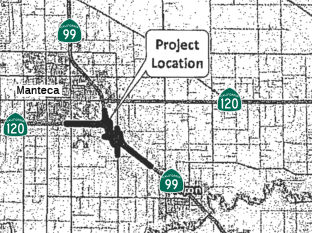
The 2018 STIP, approved at the CTC March 2018 meeting, appears to show $12.3M allocated for construction from the 2016 STIP for PPNO 3046 Rt 120/McKinley Avenue, new interchange. In Manteca, at McKinley Avenue. Construct new interchange. This project will convert the existing grade separation at McKinley Road to a full interchange at Route 120 to provide an acceptable level of service (LOS) for the projected traffic volumes that would result from planned developments within the City of Manteca and surrounding interchanges. Local roads would not support the projected increase in demand under their existing conditions. The proposed project is needed to provide more efficient access to and from Route 120 and to accommodate traffic volumes for the planned growth areas in the vicinity of McKinley Avenue.
The 2020 STIP, approved at the CTC March 2020 meeting,
continues the programmed funding for PPNO 3046 "Rt 120/McKinley Avenue,
new interchange"
(Source: March 2020 CTC Agenda, Item 4.7, 2020 STIP
Adopted 3/25/2020)
In October 2020, the CTC approved for future
consideration of funding the following project for which a Mitigated
Negative Declaration (MND) has been completed: Route 120 in San Joaquin
County. Construct a new interchange, freeway auxiliary lanes and
connecting roadways on SR 120 in San Joaquin County. (10-SJ-120, PM
1.9/3.0) (PPNO 3046) (EA 0H890) This project is located in San Joaquin
County on Route 120 at McKinley Avenue. This is a locally implemented
project by the City of Manteca. This project will convert the existing
grade separation at McKinley Road to a full interchange at Route 120, to
provide an acceptable level of service for the projected traffic volumes
that would result from planned developments within the City of Manteca and
surrounding interchanges. The proposed project is needed to provide
more efficient access to and from Route 120 and to accommodate traffic
volumes for the planned growth areas in the vicinity of McKinley Avenue.
This is a STIP project and is funded with Regional Improvement Program
(RIP) funds, Local funds, and Federal Demonstration funds. The total cost
of the project is $44,705,000 of which $12,300,000 are RIP funds.
Construction funds were programmed in 2019-20 and a time extension was
approved by the Commission until February 2022, for a total of $12,300,000
RIP funds. The scope, as described for the preferred alternative, is
consistent with the project scope programmed by the Commission in the
STIP.
(Source: October 2020 CTC Agenda, Agenda Item
2.2c.(1))
In March 2021, it was reported that the interchange at
McKinley Avenue along the Route 120 Bypass was expected to be in place by
the summer of 2023. There are just a few issues preventing the city from
going to bid and breaking ground on the project that has been in the
making for more than a decade. One of those issues is the need for
PG&E to relocate power poles. Unlike the Union Road/Route 120 Bypass,
where PG&E had to relocate major transmission lines and declined to
split the $3 million tab, the lines involved are distribution lines that
serve homes. The McKinley Avenue interchange is needed for a variety of
reasons.
(Source: Manteca/Ripon Bulletin, 3/17/2021)
In January 2022, the CTC approved the following
allocation for a locally-funded STIP project: $12,300,000 for the McKinley
Avenue/Route 120 Interchange project, on the State Highway System
(10-SJ-120 R0.9/R3.3), in San Joaquin County. (PPNO 3046). 10-SJ-120 R2.0/R2.6
R0.9/R3.3. PPNO 10-3046; ProjID 1012000159; EA 0H890. McKinley
Avenue/State Route 120 Interchange. Route 120 In Manteca, at
McKinley Avenue. Construct new interchange.
(Source: January 2022 CTC Agenda, Agenda Item
2.5c.(2))
In late 2010, it was noted that the mayor of Manteca believes an effort
may have to get underway in the next four years to push for adding a third
lane in each direction. The biggest roadblock is the need to have two
transition lanes onto southbound Route 99 to ease the daily commute
slowdown. That could happen once the city is able to secure a new
interchange on Route 99 south of Austin Road (99 SJ 4.895). Such a move
would eliminate the on and off ramps at Austin Road.
(Source: Manteca/Ripon Bulletin, 12/31/2010)
Union Road DDI Project (SJ R4.321)
In June 2019, it was reported that despite the claims
of Ceres on Route 99 to have the first DDI (Diverging Diamond
Interchange), that honor may go to Route 120 at Union Road. The City of
Manteca recently broke ground on construction of California’s first
Diverging Diamond Interchange, at Route 120 and Union Road. The Diverging
Diamond Interchange, commonly abbreviated DDI, is a cutting-edge design
that reduces conflict points between vehicles and moves traffic more
efficiently through the interchange. DDIs have been gaining popularity
throughout the United States since the early 2000s, but until now, one had
not been constructed in California. The DDI is unique in that traffic on
the freeway overpass is shifted to the left side of the road, before being
shifted back to the right. Construction of the DDI at Route120 and Union
Road will modify the existing interchange to add additional traffic
capacity and improve operations. As the prime consultant in charge of
design of the modification, Mark Thomas worked closely with the City of
Manteca and Caltrans to gain project approval for the DDI. Caltrans
guidelines and approval processes were being developed as design work on
Route 120/Union Road Interchange progressed, so we partnered with Caltrans
District 10 and Headquarters to gain acceptance for the design. Union Road
is a key crossing of Route 120 in the City’s bicycle master plan,
and there is not currently any sidewalk or bike path through the area. The
new Class I path will provide a 12-foot wide grade-separated trail that
eliminates all bicycle/vehicle conflict points within the interchange to
provide safe and efficient passage for bicycles and pedestrians.
(Source: Mark Thomas, 6/25/2019; UnionRoad
Project Page)\
In November 2020, it was reported that
California's first diverging diamond interchange (DDI) has finally debuted
in Manteca.
(Source: ABC 10, 11/19/2020)
Route 120 Bypass Safety Improvements (SJ R4.321 to SJ T6.699)
In September 2020, it was reported that there are
increasing concerns about safety along the Route 120 Bypass approaching
Route 99, especially for drivers heading south toward Ripon and Modesto.
This is leading Caltrans to set in motion the first phase of a $131.5
million project at the intersection of the Route 120 Bypass and Route 99 to improve vehicle movements and capacity. The project, expected
to break ground in late 2021, won’t be in place until 2023. Before
then, Caltrans is taking steps aimed at reducing the potential for carnage
until two lanes are in place for eastbound Route 120 heading toward
Modesto. Interim improvements include placement of lane delineators and
route shields on the pavement for EB Route 120 traffic as it approaches
the Route 99 interchange. This is in addition to the auxiliary lanes that
will open in November 2020 between the Main Street, Union Road, and
Airport Way interchanges that are part of Manteca’s $28.4 million
diverging diamond interchange at Union Road. The new safety measures are
the outgrowth of a 120 Bypass safety committee working with Caltrans and
the California Highway Patrol. In 2019. in a bid to improve safety and
discourage last-minute lane changes, Caltrans installed 2,700 feet of
wider, 8-inch, double-white striped lane delineation from just east of the
Main Street overcrossing to the southbound Route 99 connector ramp.
Crossing over double-white stripes is a traffic violation. Stay In Lane
signs were installed on both shoulders, just west of Van Ryn Avenue
bridge, to help reduce the frequency of vehicles queue-jumping for
southbound Route 99 and sideswipe collisions. Watch For Stopped Vehicle
signs were also installed on both shoulders, just west of the Main Street
overcrossing, to help reduce the number of rear-end collisions. Those
improvements were made after Caltrans installed advisory signs on the
Airport Way and Union Road overcrossing advising motorists of the
upcoming lane splits.
(Source: Manteca/Ripon Bulletin, 9/4/2020)
The first phase of the projected interchange
improvements in 2021 involve:
(Source: Manteca/Ripon Bulletin, 9/4/2020)
Route 99/Route 120 Connector Improvements near Manteca (10-SJ-120 PM T6.624/6.295)
 The 2018 STIP, approved at the CTC March 2018 meeting, appears to allocate $13.550 for PPNO 3162, the Route 99/Route 120 Connector near Manteca (~ SJ 5.722)
In October 2019, the CTC had on its agenda for future
consideration of funding the following project: 10-SJ-99 PM 3.1/6.2 Route 99 and Route 120 in San Joaquin County. Construct roadway and interchange
improvements on Route 99 at Route 120 near the city of Manteca in San
Joaquin County. (PPNO 3162, Proj ID 1016000038 EA 1E740). This project is
located near the eastern/southeastern border of the City of Manteca on
Route 99/Route 120 in San Joaquin County. This project proposes to
construct improvements to the Route 99/Route 120 interchange. The project
is divided into three phases. The purpose is to reduce traffic congestion
and improve operations of Route 99 with the Route 120 and Austin Road
interchanges. Phase 1A of this project is currently programmed in the 2018
STIP with $13.6 million in Regional Improvement Program funds and $3.4
million in Senate Bill 1 Local Partnership Program funds for Construction
(capital and support) and Right-of-Way (capital and support). Phase 1A is
currently not fully funded, but it is a candidate for the 2020 SHOPP. The
total cost estimate for this project is $115.3 million which includes all
three phases. Construction is estimated to begin in Fiscal Year 2020-21.
The scope, as described for the preferred alternative, is consistent with
the project scope programmed by the Commission in the 2018 STIP.
(Source: October 2019 CTC Agenda, Agenda Item
2.2c.(1))
Also in October 2019, the CTC approved an allocation of
$3,408,000 for the SB 1 Local Partnership Program (LPP) (Formulaic) Route 99/Route 120 Connector Project (PPNO 3162). Add new auxiliary lanes,
upgrade existing bridges, relocate an at-grade railroad crossing,
intersections, construct additional connector lanes, ramp upgrades, and
new signals/lighting. Due to funding constraints, the Project will be
constructed in three phases. The initial phase will construct a second
lane on the eastbound Route 120 to southbound Route 99 connector and
auxiliary lanes, which will require the partial closure of the Austin
Road/Route 99 interchange. The second phase will widen the connector from
northbound Route 99 to westbound Route 120 to two lanes an widen Route 120
from four lanes to six between Main Street and SR 99. The third phase will
construct braided ramps to the Austin Road interchange to restore full
access.
(Source: October 2019 CTC Agenda, Agenda Item
2.5s.(1))
In February 2020, this project was programmed in the
STIP Regional Improvement Program (RIP) for $10,142,000 in Construction
($4,942,000 in Construction Capital and $5,200,000 in Construction
Support) for allocation in Fiscal Year 2021-22.
(Source: January 2024 CTC Agenda, Agenda Item 2.5s.(4))
The 2020 STIP, approved at the March 2020 CTC meeting,
made a number of adjustments related to this:
(Source: March 2020 CTC Agenda, Item 4.7, 2020 STIP
Adopted 3/25/2020)
| PPNO | Project | Prior | 20-21 | 21-22 | 22-23 | 23-24 | 24-25 |
| 3162 | Rt 99/120 Connector | 3,408K | 10,142K | 0 | 0 | 0 | 0 |
| 3162 | Rt 99/120 Connector | -3,408K | -10,142K | 0 | 0 | 0 | 0 |
| 3162A | Rt 99/120 Connector, Phase 1A | 3,408K | 0 | 10,142K | 0 | 0 | 0 |
| 3162B | Rt 99/120 Connector, Phase 1B | 0 | 0 | 0 | 0 | 7,893K | 0 |
In May 2020, this project’s financial
contribution from the State Highway Operation and Protection Program
(SHOPP), project EA 1E74U/PPNO 3126A, was programmed for $28,736,000 in
Construction Capital for allocation in 2021-22.
(Source: January 2024 CTC Agenda, Agenda Item 2.5s.(4))
In June 2022, the Draft 2022 Program Environmental
Impact Report for the Regional Transportation Plan/Sustainable Communities
Strategy (RTP/SCS) was released. It included the following projects:
(Source: Draft Program EIR for the RTP/SCS, June 2022)
In June 2022, the project received a 20-month
allocation time extension for the Construction phase.
(Source: January 2024 CTC Agenda, Agenda Item 2.5s.(4))
In May 2023, the CTC received notice of a forthcoming
STIP amendment that would amend the 2022 STIP to move $13,125,00 in
Construction (CON) Regional Improvement Program (RIP) funds from Fiscal
Year 2023-24 to 2025-26 for the Route 99/Route 120 Connector Project Phase
1B (PPNO 3162B), in San Joaquin County, per STIP Guidelines. The Route 99/Route 120 Connector Project Phase 1B (PPNO 3162B) project will improve
the connector from northbound Route 120 by widening the connector to two
lanes and adding a merge/weave lane on westbound Route 120 between Route 99 and the Main Street Interchange. The eastbound Route 120 to northbound
Route 99 connector will be replaced with a new structure to allow the
existing Route 99/Route 120 separation structure to be converted to two
westbound lanes. This project is critical to the region, as it will
relieve traffic congestion and improve operation of Route 99 with the
Route 120 and Austin Road Interchanges. Unfortunately, the Phase 1A
component of the project has experienced delays associated with Union
Pacific Rail Road and Pacific Gas and Electric, as many new utility
relocations have been requested by these agencies. These approvals are
required for securing Right of Way certification. The Phase 1B component
of the project is scheduled to begin construction immediately upon the
completion of Phase 1A. As such, an amendment to the programmed CON funds
for Phase 1B is needed. This request is to move the project’s CON
RIP funding from 2023-24 to 2025-26.
(Source: May 2023 CTC Agenda, Agenda Item 2.1b.(21))
In November 2023, the Engineer’s Estimate (EE)
reflected the need for $11,119,000 in Construction Capital (125.0 percent
over the programmed amount) and $5,200,000 in Construction Support (no
increase over the programmed amount) from the STIP-RIP, $1,349,000
in Construction Capital from the LPP (Formulaic), and $32,079,000 in
Construction Capital from the SHOPP. The additional funds are
requested to come from San Joaquin Council of Governments’ (SJCOG)
STIP-RIP shares. The remaining increase will be funded by regionally
administered funds. SJCOG plans to advertise the project in February
2024 and begin construction in May 2024. Construction is planned for
two construction seasons with a duration of 355 working days.
(Source: January 2024 CTC Agenda, Agenda Item 2.5s.(4))
In January 2024, the CTC approved the following
construction phase allocation, which represents a 125% increase in
Construction: $17,668,000. 10-SJ-99 3.1/6.2. PPNO 10-3162A; ProjID
1016000038; EA 1M290. SR 99/120 Connector Project Phase 1A. In
and near the City of Manteca, widen the eastbound Route 120 to southbound
Route 99 connector ramp from one-lane to two lanes; Remove the Austin Road
overcrossing and replace with a new 4-lane structure spanning Route 99 and
UPRR; add a new connecting road from Austin Road to East Woodward Avenue
and Moffat Boulevard and modify the existing UPRR gated crossing at East
Woodward Avenue to conform to the new connector road; modify the existing
northbound Austin Road exit ramp to conform to the higher overcrossing
profile grade; Temporarily close the Austin Road northbound entrance and
southbound exit ramps; resulting in a partial interchange. CEQA - MND,
08/22/2019; Re-validation 11/17/2023. NEPA - CE, 09/25/2019; Re-validation
11/17/2023. Right of Way Certification: 11/15/2023. Future consideration
of funding approved under
Resolution E-20-15; March 2020. Time extension for LPP-F FY 22-23 CONST
expires on June 30, 2024 and for RIP FY 21-22 expires on February 29,
2024. Concurrent allocation for SHOPP Project EA 10-1E74U FCO for
$32,079,000 under Resolution FP-23-64. Contribution from other sources:
$3,229,000. Additional $6,177,000 increase will be funded with future
SJCOG RIP shares. ALLOCATION IS CONTINGENT UPON THE APPROVAL OF A BUDGET
REVISION BY THE DEPARTMENT OF FINANCE. The Construction Capital is greater
than the programmed amount due to modifications to the original structure
design and adjustments made to the EE to reflect recent bids for
electrical items. A portion of this project will replace the existing
2-lane Austin Road OC with a 4-lane OC. The estimate from the
Project Report (PR) for the Austin Road OC was $16,920,000, which included
mobilization and contingency. The current Construction Capital
estimate (without mobilization and 10 percent contingency) is now
$22,072,000 or approximately 30 percent higher. Most of this cost is in
the structure footings which required longer and stiffer piles due to the
potentially liquifiable soils compared to what was estimated before the
geotechnical investigations were completed. In addition, based on comments
from the Department’s Structures office, the project team has
redesigned the structure to use a three-column bent rather than the
four-column bent shown in the 65 percent plans. The roadway costs are
currently estimated at $19,930,000, which is approximately $6,403,000
higher than the PR estimate. The majority of this increase is
attributable to the electrical items, which increased by a total of
$4,055,000. This includes the addition of items to interconnect the
City’s signals, to modify the fiber optic line installed by the
Department in 2018, and to modify the Department’s traffic count
stations that were not anticipated in the PR. The estimate for the
four new traffic signals was approximately $600,000 higher than the PR
estimate due to the higher costs of electrical materials and the new
Woodward/Atherton signal is more expensive that the three-legged signal on
the old roadway that bifurcated the Betschart parcel. Approximately
$1,748,000 is attributed to several minor quantity adjustments to roadway
items prior to Ready to List. The remaining cost changes are attributable
to the unit cost adjustments and result in a need of an additional
$6,177,000. The increases will be funded from future STIP RIP
shares, financial contribution from the SHOPP, and regionally administered
funds.
(Source: January 2024 CTC Agenda, Agenda Item 2.5s.(4))
Manteca (Route 99) to Adela
In May 2012, the CTC authorized relinquishment of right of way in the city of Manteca along Route 120 on Austin Road (~ SJ 6.843), consisting of a collateral facility.
Murphy Road Roundabout (10-SJ-120 10.82)
In December 2023, the CTC approved amending the
following project into the 2022 SHOPP: 10-SJ-120 10.82. PPNO 10-3620;
ProjID 1022000221; EA 1Q010. Route 120 Near Manteca, at the intersection
with Murphy Road. Improve safety by constructing roundabout.
Concurrent COS allocation under Resolution FP-23-49; December 2023.
Allocation ($ × $1000) PA&ED $1,530; PS&E $2,467; R/W Sup
$498 ; Con Sup $1,159; R/W Cap $942 ; Const Cap $5,870; TOTAL $12,466.
FY25-26 BC: 11/27/2026.
(Source: December 2023 CTC Agenda, Agenda Item 2.1a.(1a) #27)
In December 2023, the CTC approved the following SHOPP
preconstruction-phase allocation:. $1,530,000. 10-SJ-120 10.82. PPNO
10-3620; ProjID 1022000221; EA 1Q010. Route 120 Near Manteca, at the
intersection with Murphy Road. Improve safety by constructing roundabout.
Concurrent Amendment under SHOPP Amendment 22H-014; December 2023.
Programmed (Allocation, if different): PA&ED
$1,530,000.
(Source: December 2023 CTC Agenda, Agenda Item 2.5b.(2) #8)
French Camp Road Roundabout Intersection
Improvements (10-San Joaquin-120 PM 11.6)
In March 2020, the CTC amended the following project
into the 2018 SHOPP: 10-SJ-120 11.6 PPNO 3477 ProjID 1019000084 EA 1K460
Route 120 near Manteca, at French Camp Road. Construct roundabout. Total
cost: $16,204K. BC 12/16/2024. Construction and R/W acquisition not yet
programmed. The CTC also approved the following financial allocation:
10-SJ-120 PM 11.6. PPNO 3477. ProjID 1019000084. EA 1K460. Route 120 near
Manteca, at French Camp Road. Construct roundabout. (Concurrent Amendment
under SHOPP Amendment 18H-015; March 2020.) Financial allocation:
PA&ED $1,660,000
(Source: March 2020 CTC Agenda, Agenda Item
2.1a.(1a) #28, 2.5b.(2a) #31)
The 2020 SHOPP, approved in May 2020, included the
following Collision Reduction item of interest (carried over from the 2018
SHOPP): 10-San Joaquin-120 PM 11.6 PPNO 3477 Proj ID 1019000084 EA 1K460.
Route 120 near Manteca, at French Camp Road. Construct roundabout.
Programmed in FY23-24, with construction scheduled to start in December
2024. Total project cost is $16,204K, with $10,536K being capital (const
and right of way) and $5,668K being support (engineering, environmental,
etc.).
(Source: 2020 Approved SHOPP a/o May 2020)
In August 2021, the CTC approved the following
preconstruction allocation: 10-SJ-120 11.6. PPNO 10-3477; ProjID
1019000084; EA 1K460, Route 120 Near Manteca, at French Camp Road.
Construct roundabout. Allocation: PS&E $1,598,000 R/W Sup
$591,000 ($350,000 programmed).
(Source: August 2021 CTC Agenda, Agenda Item
2.5b.(2a) #22)
In December 2021, the CTC approved the following SHOPP
amendment: 10-SJ-120 PM 11.6. PPNO 10-3477; ProjID 1019000084; EA 1K460.
Route 120 Near Manteca, at French Camp Road. Construct roundabout.
Construct signalized intersection. Note: Update description
due to change in intersection safety improvement from roundabout to
signalized intersection. Update to performance measure is due to change in
preferred alternative. Reduction in right of way capital is due to less
parcels and fewer utility relocations needed based on signalized
intersection. Reduce construction capital due to lower cost to build
a signalized intersection. Allocation changes ($1,000s): R/W Cap $2,453
⇒ $700; Const Cap $8,083 ⇒ $7,699.
(Source: December 2021 CTC Agenda, Agenda Item
2.1a.(1d) #38)
In September 2012, the CTC vacated right of way in the city of Escalon along Route 120 at Plaza Avenue (~ SJ R16.739), consisting of superseded highway right of way no longer needed for State highway purposes. The City of Escalon was given a 90-day notice of intent to vacate, without protesting such action.
In June 2008, the CTC relinquished right of way in the city of Escalon, on McHenry Avenue/Escalon Bellota Road, and Yosemite Avenue (~ SJ R16.754 to SJ R16.84), consisting of superseded highway and reconstructed and relocated city streets.
In November 2002, the CTC began exploration of construction of an expressway near Oakdale. In December 2002, the CTC considered a route adoption for a freeway location from 0.1 mi W of Valley Home Road to 2.8 mi E of Lancaster Road (10-STA-120 PM 3.0/R13.3).
Oakdale Bypass
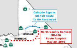 In January 2012 (and again in April 2012), the CTC approved a notice of consideration to rescind a
freeway adoption (the actual recission occured in May 2013). As
background, in the early 2000s, a consensus was reached to construct a
freeway on a new alignment along Route 120 to bypass the City of Oakdale,
also known as the Oakdale Bypass/Expressway. On December 11, 2002, the
Commission adopted the current Route 120 corridor. Numerous parcels, but
not all, were purchased to obtain the necessary right of way for the
adopted Route 120 Oakdale Bypass. Since that time, a lack of funding and
changing traffic patterns have resulted in a community and Department
agreement to drop the pursuit of the Oakdale Bypass in favor of an
alternative route. Consequently, the Department is proposing to rescind
the Route 120 freeway route adoption, from Valley Home Road to a point
approximately 2.8 miles east of Lancaster Road in Stanislaus County. Route 120 and Route 108 are the main routes to the fast growing Tuolumne County,
carrying a adediverse mixture of commercial, agricultural, recreational,
commuter, truck and local traffic. Traffic on both Route 120 and Route 108
into and through Oakdale has been growing for several decades which led to
a growing traffic congestion problem. The Department and the local
community have been struggling to address it for many years. Congestion is
most severe on weekends due to recreational traffic traveling to Yosemite
National Park, the Jamestown and Sonora areas, and points east. The
elevated interregional traffic demand often conflicts with local demand
resulting in congestion, increased noise and air pollution. The area most
severely affected is at the junction of Route 120 and Route 108 (Yosemite
Avenue and F Street) in downtown Oakdale where the level of service in
2001 was classified as “F”, representing heavily congested
traffic with long delays. The level of service was projected to continue
to degrade to „very high delays‟ by the year 2020 in the
absence of any system improvements.
In January 2012 (and again in April 2012), the CTC approved a notice of consideration to rescind a
freeway adoption (the actual recission occured in May 2013). As
background, in the early 2000s, a consensus was reached to construct a
freeway on a new alignment along Route 120 to bypass the City of Oakdale,
also known as the Oakdale Bypass/Expressway. On December 11, 2002, the
Commission adopted the current Route 120 corridor. Numerous parcels, but
not all, were purchased to obtain the necessary right of way for the
adopted Route 120 Oakdale Bypass. Since that time, a lack of funding and
changing traffic patterns have resulted in a community and Department
agreement to drop the pursuit of the Oakdale Bypass in favor of an
alternative route. Consequently, the Department is proposing to rescind
the Route 120 freeway route adoption, from Valley Home Road to a point
approximately 2.8 miles east of Lancaster Road in Stanislaus County. Route 120 and Route 108 are the main routes to the fast growing Tuolumne County,
carrying a adediverse mixture of commercial, agricultural, recreational,
commuter, truck and local traffic. Traffic on both Route 120 and Route 108
into and through Oakdale has been growing for several decades which led to
a growing traffic congestion problem. The Department and the local
community have been struggling to address it for many years. Congestion is
most severe on weekends due to recreational traffic traveling to Yosemite
National Park, the Jamestown and Sonora areas, and points east. The
elevated interregional traffic demand often conflicts with local demand
resulting in congestion, increased noise and air pollution. The area most
severely affected is at the junction of Route 120 and Route 108 (Yosemite
Avenue and F Street) in downtown Oakdale where the level of service in
2001 was classified as “F”, representing heavily congested
traffic with long delays. The level of service was projected to continue
to degrade to „very high delays‟ by the year 2020 in the
absence of any system improvements.
 In 1990, a Value Engineering study for the Route 120 Oakdale Bypass project identified a
need to further study the development of a Route 108 southern bypass as
well as the need for the Route 120 Oakdale Bypass itself. The Department
and local entities identified the preferred alternative for the Oakdale
Bypass as a northern corridor expressway starting across the Stanislaus
River near Twenty Six Mile Road and ending eight miles east of Oakdale.
The Route 120 Oakdale Bypass was adopted by sthe Commission in 2002.
During this same time period, changing traffic patterns in Stanislaus
County were fostering a growing realization that a southern bypass of
Riverbank and Oakdale (i.e. the NCC) was in critical need and should
perhaps be given a higher priority than the northern Oakdale Bypass. As a
result, StanCOG, the Cities of Modesto, Riverbank, and Oakdale, and the
County of Stanislaus identified the NCC as a priority corridor. In 2007,
following several years of project delay due to inadequate funding of the
Oakdale Bypass, the Commission redirected the Oakdale Bypass project
Interregional Transportation Improvement Program (ITIP) funds under the
authority of the resolution approving the 2006 State Transportation
Improvement Program (STIP) Augmentation, with the understanding these
funds would be restored to a viable replacement project in the future. In
May 2008, the Commission deleted all programming from the Oakdale Bypass
project under the authority of Resolution G-08-08 approving the 2008 STIP
adoption and recognizing the NCC project as the viable replacement
project. In May 2010, the Commission approved the Route Adoption of the
NCC Route 108 East under authority of Resolution HRA 10-02 Commiand HRA
10-03.
In 1990, a Value Engineering study for the Route 120 Oakdale Bypass project identified a
need to further study the development of a Route 108 southern bypass as
well as the need for the Route 120 Oakdale Bypass itself. The Department
and local entities identified the preferred alternative for the Oakdale
Bypass as a northern corridor expressway starting across the Stanislaus
River near Twenty Six Mile Road and ending eight miles east of Oakdale.
The Route 120 Oakdale Bypass was adopted by sthe Commission in 2002.
During this same time period, changing traffic patterns in Stanislaus
County were fostering a growing realization that a southern bypass of
Riverbank and Oakdale (i.e. the NCC) was in critical need and should
perhaps be given a higher priority than the northern Oakdale Bypass. As a
result, StanCOG, the Cities of Modesto, Riverbank, and Oakdale, and the
County of Stanislaus identified the NCC as a priority corridor. In 2007,
following several years of project delay due to inadequate funding of the
Oakdale Bypass, the Commission redirected the Oakdale Bypass project
Interregional Transportation Improvement Program (ITIP) funds under the
authority of the resolution approving the 2006 State Transportation
Improvement Program (STIP) Augmentation, with the understanding these
funds would be restored to a viable replacement project in the future. In
May 2008, the Commission deleted all programming from the Oakdale Bypass
project under the authority of Resolution G-08-08 approving the 2008 STIP
adoption and recognizing the NCC project as the viable replacement
project. In May 2010, the Commission approved the Route Adoption of the
NCC Route 108 East under authority of Resolution HRA 10-02 Commiand HRA
10-03.
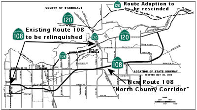
North County Corridor (~ 10-STA-120 PM 6.9-11.6)
![[108 Oakdale]](maps/108-oakdale.jpg) In May 2010, the CTC approved for future consideration of funding a project in Stanislaus County that would
study corridor options for a future alignment of Route 108 near the city
of Oakdale. There is no construction for this project because it is for
route adoption only. Once the route adoption is approved by the
Commission, and funding becomes available, the Stanislaus Council of
Governments and the Department will conduct further environmental studies
to identify a roadway alignment within the selected corridor. The
construction of the new roadway is anticipated to occur in Fiscal Year
(FY) 2025. Conceptual level cost estimates to build a new roadway range
from $600 to $800 million (FY 2009 costs), and $1.3 to $1.5 billion (FY
2030 costs). It is expected that the future project, however, will have
potential impacts to land use, farmlands, cultural resources, biological
resources, relocations, hazardous waste, water quality, paleontology, and
air quality.
In May 2010, the CTC approved for future consideration of funding a project in Stanislaus County that would
study corridor options for a future alignment of Route 108 near the city
of Oakdale. There is no construction for this project because it is for
route adoption only. Once the route adoption is approved by the
Commission, and funding becomes available, the Stanislaus Council of
Governments and the Department will conduct further environmental studies
to identify a roadway alignment within the selected corridor. The
construction of the new roadway is anticipated to occur in Fiscal Year
(FY) 2025. Conceptual level cost estimates to build a new roadway range
from $600 to $800 million (FY 2009 costs), and $1.3 to $1.5 billion (FY
2030 costs). It is expected that the future project, however, will have
potential impacts to land use, farmlands, cultural resources, biological
resources, relocations, hazardous waste, water quality, paleontology, and
air quality.
Specifically, the proposal is to modify the adopted route for Route 108 in Stanislaus County, in the vicinity of the cities of Modesto, Riverbank, and Oakdale. The ultimate facility is planned as a multi-lane freeway/expressway corridor, approximately 18 miles long. A Project Report was approved on April 13, 2010. An Environmental Impact Report was prepared for California Environmental Quality Act and the document was approved on April 13, 2010. This 18 mile long project, referred to as the North County Corridor (NCC) Route 108 East Route Adoption, will bypass the cities of Riverbank and Oakdale, improve interregional system connectivity, and improve regional traffic operations.
Route 108 is generally classified as a minor arterial through most of the project limits except for sections through the cities of Riverbank and Oakdale that are classified as principal arterial. Existing Route 108 functions as a “main street” and is predominantly a two-lane undivided conventional facility. Between the intersection of Route 108 (McHenry Avenue)/SR 219 (Kiernan Avenue) and the intersection of Route 108/Route 120 with Lancaster Road, Route 108 is encumbered by 83 public street intersections and many private driveways with direct access onto Route 108. It is highly congested during peak travel times and these conditions are expected to worsen as traffic volumes on Route 108 increase in the foreseeable future. Increasing levels of traffic on both Route 120 and Route 108 into and through the City of Oakdale have led to a growing traffic congestion problem that the Department and the local community have been addressing for over five decades. Traffic on Route 108 includes a combination of commuter, local commerce, goods movement, agricultural and farm operations, and a large component of interregional recreational traffic. This elevated interregional traffic demand often conflicts with local traffic demand resulting in congestion, increased noise and air pollution. Route 108 provides direct access to local residences, farms, and other community facilities along its route but also travels through the busy downtown areas of Oakdale and Riverbank. Congestion is most severe during weekends due to recreational traffic traveling to Yosemite National Park, and to the Jamestown and Sonora areas. Weekdays can also be very congested due to the heavy commute traffic. The area most severely affected by congestion is at the junction of Route 108 and Route 120 (Yosemite Avenue) in downtown Oakdale where the level of service (LOS) in 2001 was classified as “F”, representing heavily congested traffic with long delays. These conditions are expected to worsen over time as development continues and traffic volumes increase. The LOS is projected to degrade to “very high delays” by the year 2020 in the absence of any system improvement.
The ultimate facility is planned as a multi-lane freeway, approximately ten miles long, from Route 219 and McHenry Avenue to just east of Albers Road and as a multi-lane
controlled access highway for the remaining eight miles until it connects
with Route 120, approximately six miles east of the City of Oakdale. The
freeway segment will serve the urban areas of Modesto, Riverbank, and
Oakdale. The controlled access highway segment is planned for the rural
area of Stanislaus County south-east of Oakdale. The route adoptions will
be executed as two concurrent CTC actions on this month’s agenda
(see also Resolution HRA 10-03). Although the North County Corridor
encompasses a roadway facility between Route 99 and Route 120, the
proposed State route adoption is only for the segment between Route 108
(McHenry Avenue) and Route 120. These limits are a result of discussions
occurring June 2008 to February 2009 between State and local entities. A
freeway adoption connecting to Route 99 was interfering with the
development of a modification proposal at the Hammett Road/Route 99
interchange. The Project Study Report for that project has assumed Hammett
would remain a local road and proposes a local type interchange at Route 99. The Department concurred to pursue evaluating the new NCC Route 108
East Route Adoption. This request is for the Freeway Route Adoption, and a
separate request is being submitted for the Controlled Access Highway
Route Adoption (Resolution HRA 10-03). These two route adoptions will
allow for the execution of a freeway agreement and a controlled access
highway agreement with Stanislaus County.
Relinquishment of the existing Route 108 will occur after construction of the new bypass. Relinquishment will transfer the State’s right of way, title, and interest of the superseded section of Route 108 to the City of Oakdale, City of Riverbank, and Stanislaus County as depicted in the attached Route Adoption Map.
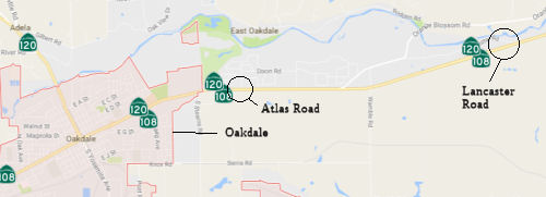 In September 2016, it was reported that one of the last
remaining battles over potential paths for the future North County
Corridor may be nearing an end, with momentum building for a tie-in with
existing Route 108 east of Oakdale at Lancaster Road. Dozens of families
in neighborhoods four miles to the west for months have protested the
concept of a roundabout at Atlas Road, with the North County Corridor
shooting south from that point and paralleling Stearns Road before
skirting Oakdale and running between Riverbank and Modesto. Oakdale
officials previously preferred the Atlas tie-in, thinking it might funnel
cars near a future shopping center; however, the city has changed its mind
and has adopted a resolution supporting the neighbor-preferred Lancaster
option. The EIR should be released in January 2017. Controversy over the
road’s western stretch, between Modesto and Riverbank, died down a
few years ago as engineers focused on redoing Kiernan Avenue, with
legitimate freeway interchanges at McHenry Avenue, Coffee and Oakdale
roads, and Roselle Avenue. If Caltrans picks the Lancaster tie-in on the
east end, the only unresolved choice would be south of Oakdale, with one
option close to the south edge of the city and the other further south,
largely focused on Claribel Road. Leaders of the county and three cities
would review the draft environmental study around March, accepting input
from the public and seeking consensus among each other. Caltrans’
final route selection could follow in early 2018.
In September 2016, it was reported that one of the last
remaining battles over potential paths for the future North County
Corridor may be nearing an end, with momentum building for a tie-in with
existing Route 108 east of Oakdale at Lancaster Road. Dozens of families
in neighborhoods four miles to the west for months have protested the
concept of a roundabout at Atlas Road, with the North County Corridor
shooting south from that point and paralleling Stearns Road before
skirting Oakdale and running between Riverbank and Modesto. Oakdale
officials previously preferred the Atlas tie-in, thinking it might funnel
cars near a future shopping center; however, the city has changed its mind
and has adopted a resolution supporting the neighbor-preferred Lancaster
option. The EIR should be released in January 2017. Controversy over the
road’s western stretch, between Modesto and Riverbank, died down a
few years ago as engineers focused on redoing Kiernan Avenue, with
legitimate freeway interchanges at McHenry Avenue, Coffee and Oakdale
roads, and Roselle Avenue. If Caltrans picks the Lancaster tie-in on the
east end, the only unresolved choice would be south of Oakdale, with one
option close to the south edge of the city and the other further south,
largely focused on Claribel Road. Leaders of the county and three cities
would review the draft environmental study around March, accepting input
from the public and seeking consensus among each other. Caltrans’
final route selection could follow in early 2018.
(Source: Modesto Bee, 9/22/2016)
The August 2017 Draft EIR noted: The proposed project
will connect Route 219 near Modesto to Route 120 near Oakdale. This
environmental document analyzes the four Build Alternatives (1A, 1B, 2A,
and 2B) and the NoBuild Alternative. The western end of all alternatives
is at the Route 219 (Kiernan Avenue)/Tully Road intersection. The project
is analyzed as three distinct segments for environmental evaluation
purposes and explaining the proposed improvements. Segment 1 represents
the more urbanized area; Segment 2 represents a transition from urbanized
to rural area; and Segment 3 represents the rural foothill area.
(Source: NCC DEIR August 2017)
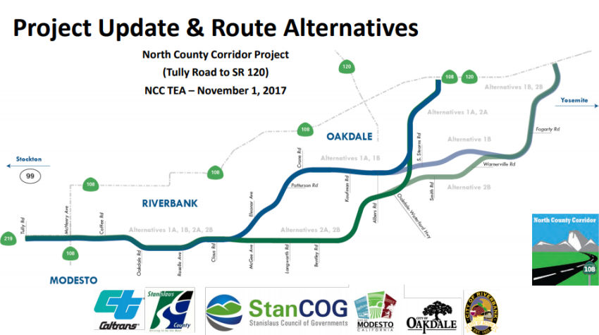 Segment 1 begins at the Route 219 Kiernan Avenue/Tully Road intersection, which is
the western end of the project for all four alternatives. All of the Build
Alternatives proceed along the same alignment, extending to the existing
Claus Road/Claribel Road intersection near the southeast portion of the
City of Riverbank and northeast portion of the City of Modesto’s
future sphere of influence, including future areas projected to be
incorporated into the City boundaries. The following
interchange/intersection designs are common to all Build Alternatives for
Segment 1: (◆) Tully Road/Route 219 (Kiernan Avenue) intersection
will consist of a modified signalized at-grade intersection; (◆)
Route 108 (McHenry Avenue)/Route 219, (Kiernan Avenue)/new Route 108,
Coffee Road/new Route 108, Oakdale Road/new Route 108, and Roselle
Avenue/new Route 108 will all consist of a proposed single-point urban
interchange and separate-grade undercrossing structures; (◆) The
Claus Road/new Route 108 signalized at-grade intersection will provide
access from the new Route 108 facility east of Claus Road as well as the
local road access to the City of Riverbank and future northeastern areas
of the City of Modesto.
Segment 1 begins at the Route 219 Kiernan Avenue/Tully Road intersection, which is
the western end of the project for all four alternatives. All of the Build
Alternatives proceed along the same alignment, extending to the existing
Claus Road/Claribel Road intersection near the southeast portion of the
City of Riverbank and northeast portion of the City of Modesto’s
future sphere of influence, including future areas projected to be
incorporated into the City boundaries. The following
interchange/intersection designs are common to all Build Alternatives for
Segment 1: (◆) Tully Road/Route 219 (Kiernan Avenue) intersection
will consist of a modified signalized at-grade intersection; (◆)
Route 108 (McHenry Avenue)/Route 219, (Kiernan Avenue)/new Route 108,
Coffee Road/new Route 108, Oakdale Road/new Route 108, and Roselle
Avenue/new Route 108 will all consist of a proposed single-point urban
interchange and separate-grade undercrossing structures; (◆) The
Claus Road/new Route 108 signalized at-grade intersection will provide
access from the new Route 108 facility east of Claus Road as well as the
local road access to the City of Riverbank and future northeastern areas
of the City of Modesto.
Segment 2 is where the four similar alternatives separate into two different alignments (1A/1B and 2A/2B). In Segment 2, Alternatives 1A and 1B veer northeast from near the existing Claus Road/Claribel Road intersection and pass through the southern boundary of the City of Oakdale to just east of Albers Road, and Alternatives 2A and 2B continue to extend easterly along Claribel Road and veer northeastward past the intersection of Claribel Road/Bentley Road to just east of Albers Road. In Segment 2:
In Segment 3, Alternatives 1A and 2A merge as similar alignments at the southern end of the City of Oakdale and continue on the same alignment to the proposed eastern end (A) at the new Route 108/Route 120 intersection just east of the City of Oakdale boundary. In Segment 3, Alternatives 1B and 2B merge as similar alignments north of the existing Warnerville Road/Emery Road intersection and continue on a northeasterly direction to the proposed other eastern end (B) at the new Route 108/Route 120 intersection west of the existing Route 120/Lancaster Road intersection. In Segment 3:
In November 2018, the Stanislaus County Public Works
Department noted that, on October 3, 2016, the Oakdale City Council passed
a resolution of preliminary support for NCC Alternatives 1B and 2B. With
the official release of the Draft EIR/EIS on August 9, 2017, City staff
has had the opportunity to review the Draft EIR/EIS and believes that
Alternative 1B should be the preferred alternative. At their September 18,
2017 meeting, the Oakdale City Council unanimously passed a resolution to
send Caltrans an official comment letter stating the City’s
preference for Alternative 1B. On October 24, 2017 City of Riverbank City
Council took the same action for similar reasons. The Riverbank City
Council unanimously passed a resolution adopting Alternative 1B as the
City’s preferred North County Corridor route Alignment.
(Source: Stanislaus County Public Works Presentation, 11/2018)
In December 2018, it was reported that Federal highway
officials approved a $20 million grant for the North County Corridor, a
future expressway skirting Modesto, Riverbank and Oakdale in north
Stanislaus County. The road is expected to cost $688 million and will
require additional funding. State transportation officials are expected to
pinpoint the exact route in early 2019, and construction could be a few
years away. The project was one of only four in California drawing BUILD
money, formerly known as TIGER grants; BUILD stands for Better Utilizing
Investments to Leverage Development. The corridor will be a west-east
facility from Route 108 (McHenry Avenue) north of the City of Modesto to
Route 120 approximately six miles east of the City of Oakdale. This new
roadway would be approximately 18 miles in length from a location on Route 219 (Kiernan Avenue) to a location on Route 120 approximately six miles
east of the City of Oakdale. The project may be an entirely new roadway or
incorporated into the existing roadway network and would serve as a bypass
for the cities of Riverbank, Oakdale and Modesto. The North County
Corridor Transportation Expressway Authority anticipates that the ultimate
facility would be planned as a multi-lane, access-controlled
expressway/freeway, with interchanges, at-grade intersections,
grade-separated railroad crossings, irrigation district crossings,
frontage roads, and local street alignments. Various roadway alignment
alternatives will be considered. The proposed roadway would be built in
existing unincorporated Stanislaus County. Funding for this phase of the
project is being provided by regional transportation impact fees and the
state funding that was once part of the cancelled state Oakdale Bypass
project.
(Source: Modesto Bee, 12/10/2018; NorthCounty
Corridor Webpage)
In June 2020, it was reported that the EIS for the
Route 108 Modesto bypass expressway, the first phase of which extends from
the Route 108/Route 219 junction north of Modesto to a terminus at present
Route 108/Route 120 east of Oakdale, has been approved. Stanislaus
County has a corridor design simulator that follows the facility, which is
being designed as a combination freeway/expressway, from west to
east. The routing has three roundabouts on the main expressway lanes
(3+3 on the west end; 2+2 east of Riverbank), along with several
interchanges at major arterials. Two of these are multi-lane; the
last one is at the eastern terminus as the connector to Route 120.
The expressway is designed to be upgradeable to full freeway (likely with
bridges over the circles); also, in a future phase this corridor will
follow Route 219 west to Route 99 near Salida.
(Source: Scott Parker on AARoads, "Re: California", 6/11/2020)
In December 2020, the CTC approved a route adoption and
future consideration of funding for the following project for which a
Final Environmental Impact Report (FEIR) has been completed: Route 108,
Route 219, and Route 120 in Stanislaus County (10-Sta-108, PM 27.5/44.5
• 10-Sta-219, PM 3.7/4.8 • 10-Sta-120, PM 6.9/11.6).
Construct a new freeway east of the City of Oakdale in Stanislaus County.
(PPNO 0228) This project is located on Route 108, Route 219, and
Route 120 in Stanislaus County, in the City of Modesto, City of Riverbank,
and City of Oakdale, from 0.1 mile west of the Route 219 (Kiernan
Avenue)/Tully Road Intersection in Stanislaus County to the new Route 108/Route 120 Junction east of the City of Oakdale. The purpose of this
project is to reduce average daily traffic volumes and traffic congestion
as well as accommodate anticipated future traffic on SR 108 and the
surrounding regional transportation network. This project is not fully
funded and the total project cost is $915,000,000. Construction is
estimated to begin in 2023.
(Source: December 2020 CTC Agenda, Agenda Item
2.2c.(1))
In January 2024, Caltrans released the draft 2024 SHOPP, which contained
the following project: 10-Stanislaus-120 R15.04. PPNO 10-3557; ProjID
1021000170; EA 1N350 . Route 120 Near Oakdale, at Wildcat Creek Bridge
№ 38-0009. Replace 14-foot culvert with a single-span bridge to
improve fish passage. Proposed ($ × 1000): PA&ED: $2,231;
PS&E: $2,697; R/W $275; R/W Sup $67; Con $11,862; Con Sup: $5,386;
Total: $22,518. Begin Con: 12/15/2028.
(Source: 2024 Draft SHOPP v4.0, 1/31/2024)
Yosemite Junction (~TUO 12.101)
In June 2015, it was reported that Tuolumne County
transportation officials are proposed their own construction project
preference to Caltrans proposed plans for improving safety and congestion
problems at Yosemite Junction (where Route 108 and Route 120 meet).
Caltrans has proposed two options; one involving a stop light and the
other a roundabout. Both would include adding additional lanes in both
directions on Route 108. The county is concerned about the limited site
distance coming down the hill into the intersection. They are also
concerned, for the eastbound traffic, that once past the intersection,
must go directly up a steep grade with a single lane that widens to a
passing lane farther up the highway. They would like to see the second
lane start before the intersection so trucks can cue up there. They also
suggested, if there is a light, it should be coordinated with the light at
O’Byrnes Ferry Road and perhaps use technology to identify, when
trucks are going in the eastbound direction, to hold the light green so
they can keep their momentum going up the hill.
(Source: MyMotherLode, 6/11/2015)
In April 2019, it was reported that Caltrans was
preparing a highway improvement project that will upgrade the junction of
Route 108 and Route 120 at Yosemite Junction. Road construction starts in
early May 2019, with the project expected to finish in August 2019.
Caltrans will make roadway improvements and install a traffic signal,
using a “High-T” intersection configuration. This is similar
to a typical signalized intersection, except that westbound traffic on
Route 108 would only be forced to stop when a pedestrian or cyclist is
crossing. Because few pedestrians are anticipated and bicycle volumes are
low at this location, the “High-T” signal for these westbound
vehicles will be green most of the time. The signal will have a greater
impact for vehicles on westbound Route 108 turning left onto Route 120,
and vehicles on eastbound Route 120. Currently, vehicles turning left at
the intersection have to wait for a suitable pause in traffic before
turning. There are times traffic is so intense that CHP directs vehicles
through the intersection. Caltrans’ project also will benefit
motorists approaching the three-way intersection from westbound Route 120
– a busy route, as Route 120 delivers visitors to and from Yosemite
National Park and foothill towns that dot the highway. After the project
is completed, a traffic signal will provide ample opportunities for
vehicles turning left while staying on Route 120. As added safety
measures, Caltrans will extend the left-turn lane on Route 108 and the
‘refuge’ lane for vehicles on westbound Route 120 turning left
onto Route 120. That ‘refuge’ lane provides time and space for
vehicles to match the flow of traffic before entering the mainline. A
cement curb will separate the left-turn and ‘refuge’ lanes
from the mainline. George Reed Inc. of Modesto will perform this work for
$3.3 million.
(Source: Caltrans District 10 FB Post, 4/25/2019)
Chinese Camp to Yosemite National Park
Tuolumne River Bridge (120 TUO 19.61)
In May 2016, it was reported that Caltrans is spending
nearly $21-million into a project on Route 120 to provide updates and
upgrades to the Tuolumne River Bridge. The bridge has not had a major
overhaul since it was built 46 years ago, in 1970. The bridge deck will be
replaced entirely. The bridge rails will be upgraded. The structure will
be strengthened to improve its ability to withstand an earthquake. These
improvements will help provide an additional forty years of service life
to the bridge. Work on the 1,400 foot long bridge, which spans the Don
Pedro Reservoir, is scheduled to begin after July 4, 2016, and wrap up in
November 2017 before Thanksgiving.
(Source: MyMotherLode.Com, 5/11/2016)
In July 2016, it was reported that travellers may
encounter significant delays on Route 120 until some time in 2017 as the
California Department of Transportation works on the James E. Roberts
Memorial Bridge. The bridge, on Route 120 at Don Pedro Reservoir, is along
the stretch of road that is both Route 120 and Route 49 before Route 120
breaks off toward Yosemite. Workers are scheduled to replace the bridge
deck and retrofit the structure, adding an estimated 40 years of service.
Traffic will be limited over the bridge to one way at a time throughout
the $20.8 million project, according to Caltrans. Completion is scheduled
for November 2017.
(Source: Roadnet.Com, 7/11/2016)
In December 2017, it was reported that the James E.
Roberts Memorial Bridge was essentially completed and was reopening to
two-way traffic.
(Source: MyMotherLode.Com, 12/22/2017)
Near Groveland, there are some interesting markers that have similar physical characteristics to a postmile marker, but instead read "ESA Begin" and "ESA End". This mark Environmentally Sensitive Areas. The sign code is G11-10, and it is illustrated here. These markers are used to mark the limits of an environmentally sensitive area within the State highway right of way. In this case, these are likely lengths of the highway where runoff has the potential to end up in the Hetch Hetchy Aqueduct.
 Business Routes
Although there is no mention of Business Route 120 through Manteca, all portions of Yosemite Avenue through Manteca that are not currently signed as Route 120 are actually old Route 120.
 Suffixed Routings
 Naming
 The portion of Route 120 in the City of Manteca from PM
SJ R1.845 to SJ R6.431 is name the “Mayor Jack Snyder Memorial
Highway”. It was named in memory of Mayor Jack C. Snyder, who
was born in Toledo, Ohio in November 1926, and who moved to Manteca,
California in 1962. Snyder’s dedication to serving his community
began on the Manteca City Council, where he served for 24 years, the
longest tenure in the City of Manteca’s 103-year municipal history.
Snyder worked tirelessly to gain support for the approval to build the
Route 120 bypass despite his colleagues’ skepticism of the project.
Snyder enlisted a group of dedicated volunteers to spend their weekends
traveling to the bay area to help gain support for a Route 120 bypass by
handing out flyers, speaking on radio stations, reaching out to
newspapers, and speaking with commuters who were traveling to and from the
bay area, facing incredible amounts of traffic in the Manteca area. Snyder
was able to successfully gain the needed support to begin building the
highway and stunned those who believed that his goal was not obtainable.
Snyder was instrumental in the creation of a greatly needed community park
for children, young adults, and families: Snyder’s colleagues on the
Manteca City Council were supportive of bypassing an opportunity for a new
local park by allowing the land to be sold to housing developers instead;
and Snyder prevailed by garnering plentiful community support that would
eventually lead to the creation of what is now known as Northgate
Community Park. Snyder continued his work supporting children and youth
who often faced juvenile delinquency issues in the community by creating a
local branch of the Boys & Girls Club of America in the 1970s, and
Snyder served on the local Boys & Girls Club of America Board for
decades to come. Snyder was also crucial to the establishment of a local
citizens volunteer corps titled “Seniors Helping Area Residents and
Police,” which was dedicated to helping patrol officers free up time
by assisting with routine duties and serving as extra eyes throughout
neighborhoods. Snyder passed away on April 20, 2021, at 94 years of age.
Named by Assembly Resolution ACR 138, Res. Chapter 128, 08/19/22.
The portion of Route 120 in the City of Manteca from PM
SJ R1.845 to SJ R6.431 is name the “Mayor Jack Snyder Memorial
Highway”. It was named in memory of Mayor Jack C. Snyder, who
was born in Toledo, Ohio in November 1926, and who moved to Manteca,
California in 1962. Snyder’s dedication to serving his community
began on the Manteca City Council, where he served for 24 years, the
longest tenure in the City of Manteca’s 103-year municipal history.
Snyder worked tirelessly to gain support for the approval to build the
Route 120 bypass despite his colleagues’ skepticism of the project.
Snyder enlisted a group of dedicated volunteers to spend their weekends
traveling to the bay area to help gain support for a Route 120 bypass by
handing out flyers, speaking on radio stations, reaching out to
newspapers, and speaking with commuters who were traveling to and from the
bay area, facing incredible amounts of traffic in the Manteca area. Snyder
was able to successfully gain the needed support to begin building the
highway and stunned those who believed that his goal was not obtainable.
Snyder was instrumental in the creation of a greatly needed community park
for children, young adults, and families: Snyder’s colleagues on the
Manteca City Council were supportive of bypassing an opportunity for a new
local park by allowing the land to be sold to housing developers instead;
and Snyder prevailed by garnering plentiful community support that would
eventually lead to the creation of what is now known as Northgate
Community Park. Snyder continued his work supporting children and youth
who often faced juvenile delinquency issues in the community by creating a
local branch of the Boys & Girls Club of America in the 1970s, and
Snyder served on the local Boys & Girls Club of America Board for
decades to come. Snyder was also crucial to the establishment of a local
citizens volunteer corps titled “Seniors Helping Area Residents and
Police,” which was dedicated to helping patrol officers free up time
by assisting with routine duties and serving as extra eyes throughout
neighborhoods. Snyder passed away on April 20, 2021, at 94 years of age.
Named by Assembly Resolution ACR 138, Res. Chapter 128, 08/19/22.
In May 2021, it was reported that Manteca Mayor Ben
Cantu it working with Assemblyman Heath Flora and Caltrans in a bid to get
the Route 120 Manteca Bypass (SJ R4.321 to SJ T6.699) named after Jack
Snyder. who passed away in April 2021 at age 94. Typically such an honor
requires the approval of the California Legislature and some sponsoring
group to pick up the cost of making and installing the signs along the
freeway. Snyder served 24 years on the Manteca City Council ——
the longest in Manteca’s 103-year municipal history. He is also the
only “comeback” council member as Snyder got appointed to a
council vacancy 12 years after leaving office and then won re-election.
Arguably Snyder’s most high profile achievement that also showcased
his uncanny sense of out-of-the-box thinking to get around seemingly
insurmountable roadblocks as well as his skill at organizing volunteers
was the Route 120 Bypass. Up until the mid-1970s, Route 120 ran through
downtown Manteca and followed the route of Yosemite Avenue that passed
Airport Way and continued westward toward the San Joaquin River. Bay Area
people traveling to and from the Sierra and the foothills for weekend
excisions had turned Route 120 through Manteca into a rolling parking lot
heading east late Friday afternoons and evenings and then head west late
Sunday afternoons. It wasn’t unusual for traffic to back up 5 miles
at a time trying to clear what were then two sets of traffic signals in
Manteca. While Manteca had only 13,000 residents, it was reported by
police and city officials that motorists at intersections without traffic
signals would have to wait sometimes an average of five minutes to
cross Yosemite Avenue during peak travel times on the weekend. Building a
bypass of Manteca on Route 120 was not even listed in the 20-year
statewide highway project plan. When area representatives in Sacramento
told the council the region lacked the political muscle at the Capitol to
get a bypass project built any sooner due to the clout of the Los Angeles
and San Francisco urban areas, Snyder decided the best move was to get the
San Francisco Bay Area on Manteca’s side. It started with a small
army of volunteers who spent Fridays and Sundays walking up to stalled
cars filled with Bay Area residents frustrated with the traffic delays and
handing them flyers. Essentially the flyers urged them to contact their
representatives to get funding for the Bypass to end their wait times
trying to get through Manteca. Snyder and his volunteers blitzed Bay Area
newspapers and radio stations to make their case and get support. In the
end political operatives were stunned that Manteca was able to line up
coastal urban support for what they had dismissed as a local highway
project. Then after a “hybrid” highway-freeway was put in
place with on and off ramps but two lanes with alternating passing lanes,
Snyder led the charge to get Caltrans to install barriers down the
centerline the length of the Bypass after 32 people died in the first 18
months of it being open.
(Source: Manteca/Ripon Bulletin, 5/19/2021; Image source: Manteca/Ripon Bulletin, 5/19/2021)
 The portion of Route 120 in
both directions between Sexton Road (SJ 120 14.834) and Brennan Road (SJ
120 15.860) in the County of San Joaquin is named the Officer Justin
Kepler Memorial Highway. It was named in memory of Justin Kepler,
who was born in April 1988, in San Jose, California. Justin Kepler
excelled in academics. At the age of 14, he passed the California High
School Proficiency Examination and received his high school diploma.
Justin Kepler went on to attend Modesto Junior College, where despite
having talents and interests that included music, language, and auto
mechanics, he received an emergency medical technician (EMT) certification
and studied criminal justice to pursue his dream of becoming a police
officer. Justin Kepler grew up in a family of law enforcement. His father,
uncle, and cousins were police officers for the San Jose Police
Department. Justin wanted to follow in his father’s footsteps, as
did his brothers, who both are currently California Highway Patrol
officers. On April 16, 2012, Justin Kepler was hired by the Stockton
Police Department and attended the South Bay Regional Public Safety
Training Consortium academy in the City of San Mateo, California. On
September 27, 2012, Justin Kepler was sworn in as a Stockton police
officer by the Chief of Police of the Stockton Police Department, Eric
Jones. During his four-year career as a police officer, Justin Kepler
obtained the status of field training officer and specialized in impaired
driving enforcement. Justin absolutely loved his career and was proud to
follow in the footsteps of his father and older brother. On August 20,
2016, Justin Kepler, 28, was riding his personal motorcycle home on Route 120 from the City of Manteca, California, where, upon approaching the
intersection at Brennan Road in the City of Escalon, he was hit by a sport
utility vehicle (SUV) and thrown approximately 35 feet. The driver of the
SUV fled the scene without reporting the accident, and Justin died on the
scene. Named by Assembly Concurrent Resolution 119, Res. Chapter 38,
09/14/20.
The portion of Route 120 in
both directions between Sexton Road (SJ 120 14.834) and Brennan Road (SJ
120 15.860) in the County of San Joaquin is named the Officer Justin
Kepler Memorial Highway. It was named in memory of Justin Kepler,
who was born in April 1988, in San Jose, California. Justin Kepler
excelled in academics. At the age of 14, he passed the California High
School Proficiency Examination and received his high school diploma.
Justin Kepler went on to attend Modesto Junior College, where despite
having talents and interests that included music, language, and auto
mechanics, he received an emergency medical technician (EMT) certification
and studied criminal justice to pursue his dream of becoming a police
officer. Justin Kepler grew up in a family of law enforcement. His father,
uncle, and cousins were police officers for the San Jose Police
Department. Justin wanted to follow in his father’s footsteps, as
did his brothers, who both are currently California Highway Patrol
officers. On April 16, 2012, Justin Kepler was hired by the Stockton
Police Department and attended the South Bay Regional Public Safety
Training Consortium academy in the City of San Mateo, California. On
September 27, 2012, Justin Kepler was sworn in as a Stockton police
officer by the Chief of Police of the Stockton Police Department, Eric
Jones. During his four-year career as a police officer, Justin Kepler
obtained the status of field training officer and specialized in impaired
driving enforcement. Justin absolutely loved his career and was proud to
follow in the footsteps of his father and older brother. On August 20,
2016, Justin Kepler, 28, was riding his personal motorcycle home on Route 120 from the City of Manteca, California, where, upon approaching the
intersection at Brennan Road in the City of Escalon, he was hit by a sport
utility vehicle (SUV) and thrown approximately 35 feet. The driver of the
SUV fled the scene without reporting the accident, and Justin died on the
scene. Named by Assembly Concurrent Resolution 119, Res. Chapter 38,
09/14/20.
(Image source: Modesto Bee)
The portion of this route from the San Joaquin county line near Escalon to Yosemite National Park (~ SJ R16.855 to TUO R56.51) is named the "Northern Yosemite Highway". It was named by Assembly Concurrent Resolution 27, Chapter 69, in 1989.
 The portion of Route 120 from the Mariposa/Tuolumne County line to the Rim of
the World Vista (~ TUO 0.000 to TUO R44.641) is named the "CDF
Firefighter Eva Marie Schicke Memorial Highway". It was named in
memory of California Department of Forestry and Fire Protection (CDF)
Firefighter Eva Marie Schicke, who passed away in the line of duty on
September 12, 2004, at the age of 23, while battling a fire in the
Stanislaus National Forest. Schicke was born in Turlock, California, in
1980 and moved to Placerville with her family in 1988. She was a two-sport
standout in basketball and volleyball at Ponderosa High School in Shingle
Springs, California. In 1998, Schicke returned to Turlock, California, to
attend California State University, Stanislaus (CSUS), where she received
a degree in criminal justice in 2002. Schicke was an outstanding
collegiate athlete. She played basketball at CSUS for four years, was a
three-year starter for the CSUS Warriors, and was the second leading team
scorer during her senior year. A highly versatile player, Schicke played
forward, point, and off-guard positions. On the court, Schicke showed the
toughness, drive, and physical prowess that made her a leader among her
teammates and later contributed to her successful firefighting career.
Schicke began her career with CDF in June 2000; her first assignment was
at the CDF station in Arnold, California. Schicke proved to be an
outstanding employee and quickly developed into a topnotch firefighter.
Her sense of humor, determination, work ethic, and mental and physical
toughness all contributed to her success with CDF. Schicke was held in
high regard by all who worked with her and was proud to have earned the
respect of her fellow firefighters. In recognition of her outstanding
abilities as a firefighter, Schicke was selected to join the crew of
Copter 404 in June of 2004. These highly coveted assignments are typically
reserved for the most experienced firefighters who demonstrate outstanding
job knowledge, work ethic, and physical conditioning. Schicke thrived on
the challenges presented by fighting wildland fires and loved the
camaraderie that she found in the station and airbase. On September 12,
2004, Schicke and the crew of Copter 404 were engaged in firefighting
efforts on a fire near Groveland, California, when Schicke and six other
firefighters were overrun by the fire. Schicke was completing her fifth
season with CDF at the time of her death and was the first female
firefighter from CDF to die in the line of duty. Schicke personified the
professionalism, work ethic, and dedication for which CDF firefighters are
known. Named by Assembly Concurrent Resolution (ACR) 156, Resolution
Chapter 166, on 9/19/2008.
The portion of Route 120 from the Mariposa/Tuolumne County line to the Rim of
the World Vista (~ TUO 0.000 to TUO R44.641) is named the "CDF
Firefighter Eva Marie Schicke Memorial Highway". It was named in
memory of California Department of Forestry and Fire Protection (CDF)
Firefighter Eva Marie Schicke, who passed away in the line of duty on
September 12, 2004, at the age of 23, while battling a fire in the
Stanislaus National Forest. Schicke was born in Turlock, California, in
1980 and moved to Placerville with her family in 1988. She was a two-sport
standout in basketball and volleyball at Ponderosa High School in Shingle
Springs, California. In 1998, Schicke returned to Turlock, California, to
attend California State University, Stanislaus (CSUS), where she received
a degree in criminal justice in 2002. Schicke was an outstanding
collegiate athlete. She played basketball at CSUS for four years, was a
three-year starter for the CSUS Warriors, and was the second leading team
scorer during her senior year. A highly versatile player, Schicke played
forward, point, and off-guard positions. On the court, Schicke showed the
toughness, drive, and physical prowess that made her a leader among her
teammates and later contributed to her successful firefighting career.
Schicke began her career with CDF in June 2000; her first assignment was
at the CDF station in Arnold, California. Schicke proved to be an
outstanding employee and quickly developed into a topnotch firefighter.
Her sense of humor, determination, work ethic, and mental and physical
toughness all contributed to her success with CDF. Schicke was held in
high regard by all who worked with her and was proud to have earned the
respect of her fellow firefighters. In recognition of her outstanding
abilities as a firefighter, Schicke was selected to join the crew of
Copter 404 in June of 2004. These highly coveted assignments are typically
reserved for the most experienced firefighters who demonstrate outstanding
job knowledge, work ethic, and physical conditioning. Schicke thrived on
the challenges presented by fighting wildland fires and loved the
camaraderie that she found in the station and airbase. On September 12,
2004, Schicke and the crew of Copter 404 were engaged in firefighting
efforts on a fire near Groveland, California, when Schicke and six other
firefighters were overrun by the fire. Schicke was completing her fifth
season with CDF at the time of her death and was the first female
firefighter from CDF to die in the line of duty. Schicke personified the
professionalism, work ethic, and dedication for which CDF firefighters are
known. Named by Assembly Concurrent Resolution (ACR) 156, Resolution
Chapter 166, on 9/19/2008.
(Image source: 2881 Fire Wire Winter 2015; CFN California Fire News;
Historically, the portion of this route between Route 108 and the Yosemite Valley (~ TUO 12.349 to TUO R56.51) was named the "Big Oak Flat and Yosemite Road". The portion betwen Oakdale and Yosemite via Groveland was locally called the "Big Oak Flat Road.
 Named Structures
Bridge 32-0018 (TUO R019.61), at the Tuolumne River in Tuolumne county, is named the "Jacksonville Bridge". It was built in 1971, and named by Assembly Concurrent Resolution 99, Chapter 124 the same year. The Jacksonville Bridge is named for the historic gold rush town of Jacksonville, founded by Col. Alden A.M. Jackson in 1849.
 Roberts") The Tuolumne River Bridge on Route 120
(again, Bridge 32-0018 (TUO R019.61)) in Tuolumne County is named the "James
E. Roberts Memorial Bridge". It was named in memory of James E.
"Jim" Roberts, in recognition of his exemplary career with the Department
of Transportation (Caltrans) as a structural engineer for a half-century.
James Roberts had a BS Civil Engineering, and began his engineering career
with Caltrans in the summer of 1953, but was deployed six weeks later to
active duty in Korea as a commissioned 2LT in the Army, where he was
involved in the rebuilding of damaged bridges after the war ended. He
remained in the Army Reserves until he retired as a colonel in 1985 after
33 years of active and reserve duty. He returned to Caltrans in the summer
of 1955 to what was then the Bridge Department, Construction Branch, and
began working on the US 101 Bypass in Cotati and eventually was moved to
work on the "Grapevine" project in Bakersfield, where he began a four-year
trek over the hill after work, to the University of Southern California
(USC), returning home around midnight, to earn his MS Structural
Engineering from USC in 1966. Jim Roberts worked his way up through the
ranks at Caltrans, until in 1981 he was promoted to Deputy of Engineering,
and then became the project director representing Caltrans in working with
the City and County of Sacramento and the Sacramento Regional Transit
District to build the light rail project. Roberts returned to Caltrans in
1985 as the manager of bridge design, and on July 1, 1987, became the
Division Chief of the Division of Structures, equivalent to Assistant
State Highway Engineer. Jim Roberts then became the Chief Bridge Engineer,
and was instrumental in establishing seismic performance criteria
following the Loma Prieta Earthquake of 1989. Jim Roberts recognized the
need for a better training program for young engineers and established the
Bridge Design Academy, and was instrumental in creating opportunities for
women to promote into higher positions in engineering. He was active in
over 17 professional organizations, including State President of the
Professional Engineers in California Government in 1972; wrote over 50
papers and publications on bridges and other transportation issues; and
was the recipient of over 20 professional awards during his career. He
retired in 2001 from Caltrans, and died on July 6, 2006. Named by Senate
Concurrent Resolution (SCR) 4, Resolution Chapter 83, on 7/10/2007.
The Tuolumne River Bridge on Route 120
(again, Bridge 32-0018 (TUO R019.61)) in Tuolumne County is named the "James
E. Roberts Memorial Bridge". It was named in memory of James E.
"Jim" Roberts, in recognition of his exemplary career with the Department
of Transportation (Caltrans) as a structural engineer for a half-century.
James Roberts had a BS Civil Engineering, and began his engineering career
with Caltrans in the summer of 1953, but was deployed six weeks later to
active duty in Korea as a commissioned 2LT in the Army, where he was
involved in the rebuilding of damaged bridges after the war ended. He
remained in the Army Reserves until he retired as a colonel in 1985 after
33 years of active and reserve duty. He returned to Caltrans in the summer
of 1955 to what was then the Bridge Department, Construction Branch, and
began working on the US 101 Bypass in Cotati and eventually was moved to
work on the "Grapevine" project in Bakersfield, where he began a four-year
trek over the hill after work, to the University of Southern California
(USC), returning home around midnight, to earn his MS Structural
Engineering from USC in 1966. Jim Roberts worked his way up through the
ranks at Caltrans, until in 1981 he was promoted to Deputy of Engineering,
and then became the project director representing Caltrans in working with
the City and County of Sacramento and the Sacramento Regional Transit
District to build the light rail project. Roberts returned to Caltrans in
1985 as the manager of bridge design, and on July 1, 1987, became the
Division Chief of the Division of Structures, equivalent to Assistant
State Highway Engineer. Jim Roberts then became the Chief Bridge Engineer,
and was instrumental in establishing seismic performance criteria
following the Loma Prieta Earthquake of 1989. Jim Roberts recognized the
need for a better training program for young engineers and established the
Bridge Design Academy, and was instrumental in creating opportunities for
women to promote into higher positions in engineering. He was active in
over 17 professional organizations, including State President of the
Professional Engineers in California Government in 1972; wrote over 50
papers and publications on bridges and other transportation issues; and
was the recipient of over 20 professional awards during his career. He
retired in 2001 from Caltrans, and died on July 6, 2006. Named by Senate
Concurrent Resolution (SCR) 4, Resolution Chapter 83, on 7/10/2007.
(Image source: National Academies Press)
 National Trails
 This portion of this segment from I-5 to Route 99
(i.e., former US 50) was part of the coast-to-coast "Lincoln Highway"
and the "Victory Highway".
This portion of this segment from I-5 to Route 99
(i.e., former US 50) was part of the coast-to-coast "Lincoln Highway"
and the "Victory Highway".
The portion of this segment from Route 108 to Yosemite National Park has historically been part of the "Mark Twain-Bret Harte Trail".
 Freeway
[SHC 253.6] Entire portion. Added to the Freeway and Expressway system in 1959.
 Scenic Route
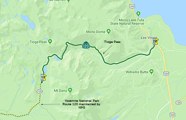 From the east boundary of Yosemite National Park to Route 395 near Mono Lake.
Post 1964 Signage HistoryThis segment is unchanged from its 1963 definition.
Pre 1964 Signage HistoryThis segment was signed as Route 120 in the initial signage of state routes in 1934 (Jct. US 99 at Manteca to Jct. Route 168 (later US 6) at Benton, via Groveland and through Yosemite National Park). It was LRN 40, defined in 1915. It includes Tioga Pass.
As for the Tioga Pass Road itself, the eastern section up Lee Vining
Canyon to the Tioga Mine was built in 1883. The connecting section of the
Tioga Pass Road from Big Oak Flat Road was built as a wagon trail from
1902 to 1910. The National Park Service purchased the Tioga Pass Wagon
Road in 1915, which was when the era of automotive travel over the road
began. Surprisingly Lee Vining Canyon has only a 7% grade which is a hell
of an accomplishment for a roadway in the eastern Sierras.
(Source: Tom Fearer (Max R) on AARoads, "Re: Tioga Pass Road", 7/8/2017)
Note: The paragraphs marked with ° are summarized and excerpted from Gribblenation Blog (Tom Fearer), "The Tioga Pass Road", September 2020. See the article for much more detail on the history of the pass.
° The road across Tioga Pass began life as the
"Great Sierra Wagon Road", proposed by the Great Sierra Company. It had an
estimated cost of $17,000 dollars in 1881 for the road from the Big Oak
Flat Road near Crane Flat east to the Tioga Peak mines. In 1882 the
Great Sierra Company authorized a survey for a wagon road and railroad to
the mines of Tioga Ridge which was completed by August during said
year. In July of 1882 the California & Yosemite Short Line
Railroad was incorporated with the intended goal of also building a rail
line to the Tioga Mining District. By September of 1883 the Great Sierra
Wagon Road had been completed east from the Big Oak Flat Road to the Tioga
Mining District. As the years wore on the Great Sierra Wagon Road remained
in periodic use but began to fall into disrepair due to a lack of
maintenance. In 1896 an appropriations bill to purchase the Great Sierra
Wagon Road was proposed but never gained traction in the House of
Representatives. In 1899 the Army was directed by Congress to survey
the Great Sierra Wagon Road. The Army determined the Great Sierra
Road, while in a state of disrepairm had been well engineered with an
average gradient of 3%. A recommendation was made by the Yosemite
National Park commissioners that the Great Sierra Wagon Road could be
repaired for $2,000 dollars, versus the cost of constructing a new highway
for an estimated cost of approximately $61,000 dollars. Yosemite
National Park thusly formally recommended that the Federal Government
acquire the Great Sierra Wagon Road. In 1911 the Federal Government
brought a lawsuit against the franchise holders of the Great Sierra Wagon
(referred to as the "Old Tioga Road"). The Federal suit argued that
the Tioga Road had been long abandoned and sought to condemn the franchise
rights so it could be incorporated as a Park Road. Ultimately the
law suit found that the owners of the Tioga Road had maintained it enough
that their claims to ownership were valid. Stephen Mather, Assistant to
the Secretary of the Interior sought to improve automotive access to
Yosemite National Park. Mather learned that the purchase price of
the Tioga Road within Yosemite National Park was $15,500 dollars.
Mather along with several other private contributors purchased the Tioga
Road with Yosemite. The Tioga Road was subsequently purchased by the
Federal Government for $10 dollars on April 10th, 1915. The Tioga
Pass Road was repaired and was opened to automotive traffic on July 28th,
1915. As noted in the discussion of LRN 40, in 1915 Legislative Chapter
306 and 396 changed the definition of LRN 40 to include all of the
segments Tioga Pass Road and Big Oak Flat Road that were not in within the
boundary of Yosemite National Park.
(Source: Yosemite.Ca via Gribblenation Blog (Tom Fearer), "The Tioga Pass Road", September 2020)
° Note that the original Tioga Pass Road diverged
from the Big Oak Flat Road at the South Fork Tuolumne River via modern
Evergreen Road. The Tioga Pass Road followed Evergreen Road to Aspen
Valley Road. The Tioga Pass Road entered Yosemite National Park via
what is now Aspen Valley Road to Aspen Valley. From Aspen Valley the
original Tioga Pass Road followed the Old Tioga Road Trail to the White
Wolf Lodge. From the White Wolf Lodge the Tioga Pass Road followed
modern White Wolf Road back to the modern Tioga Pass Road. In 1940 the
current route of the Big Oak Flat Road in Yosemite National Park was
opened between Crane Flat and Yosemite Valley. The Old Big Oak Flat
Road from Tuolumne Grove to Yosemite Valley was largely converted into a
one-way scenic alternate. Sometime between 1942 and 1944 Route 140 was cut
back to the El Portal Entrance of Yosemite on the Merced River while Route 120 was rerouted off of Evergreen Road onto the Big Oak Flat Road to Route 120 via the current Carlon Day Use Area. In 1956/1957, the New
Big Oak Flat Road between Evergreen Road and Crane Flat was opened to
traffic. After the new alignment of the Big Oak Flat Road between
Evergreen Road and Crane Flat opened the Old Big Oak Flat Road from the
Carlon Day Use Area to Tuolumne Grove was abandoned or turned into
trails. The portion of the Big Oak Flat Road from Crane Flat to the
Tuolumne Grove became part of the Tioga Pass Road.
(Source: Gribblenation Blog (Tom Fearer), "The Tioga Pass Road", September 2020)
° With respect to the eastern extension to Mono
Lake, in 1899 what would become LRN 40 was added to the State Highway
System. This was "a free wagon road from the Mono Lake Basin to and
connecting with a wagon road called the Tioga Road and near the
Tioga Mine". The Department of Public Works first considered building the
eastern extension of the Tioga Road to Mono Basin first via an established
pack trail over Bloody Pass. By 1902, a new route via Lee Vining
Canyon had been selected and construction began. By 1910
construction through Lee Vining Canyon to the Tioga Mine had been
completed to State standards.
(Source: Gribblenation Blog (Tom Fearer), "The Tioga Pass Road", September 2020)
NamingThis route was officially designated the "Great Sierra Wagon Road" and "Tioga Road". It was named by Chapter 306 in 1915.
 The portion of Route 120 from post mile MNO R0.898 to
post mile MNO R4.766 in the County of Mono is named the Chiura Obata
Great Nature Memorial Highway. It was named in memory of Chiura
Obata, who was born in November 1885 in Japan and raised in the city of
Sendai. At seven years of age, he began his formal training in the art of
sumi-e, Japanese ink and brush painting; at fourteen years of age, Obata
began an apprenticeship with a master painter in Tokyo, and in 1901, he
received a prestigious art award in Tokyo. In 1903, Obata boarded a
steamship for the United States as a teenager with a desire to see the
world and study art, eventually finding a home in San Francisco,
California. He found the California landscape to be a true inspiration for
his painting. Upon coming to the United States, Obata not only was
the recipient of intense racial epithets; he was even hit and spat upon by
people on the streets of San Francisco simply because of his ethnicity,
but he also encountered the institutionalized racism that existed in many
laws of the time that restricted the rights of Asian-born immigrants like
himself, including prohibitions from owning land and becoming a United
States citizen. Obata became an avid baseball player, playing many games
at Golden Gate Park, and was one of the founders of the Fuji Club, the
first Japanese American baseball team on the American mainland. In 1921,
Obata cofounded the East West Art Society in San Francisco with other
American, Russian, Chinese, and Japanese artists to promote a uniting of
Asian and Western art traditions. In 1927, Obata made a six week camping
trip to Yosemite and the Sierra Nevada Mountains that proved to be a
defining moment in his professional life, about which he would later say,
“This experience was the greatest harvest for my whole life and
future in painting”. Obata’s art is infused with his reverence
for nature, which he viewed as a powerful spiritual force; he thought of
nature as dai-shizen, or Great Nature, reflecting his belief that it is an
essential source of inspiration and peace for all human beings. In 1932,
Obata began his career as an influential educator, teaching in the art
department at the University of California, Berkeley for nearly 20 years.
After the attack on Pearl Harbor in December 1941, the President’s
Executive Order No. 9066 resulted in the forced removal of all Japanese
Americans on the west coast of the United States; Obata lost his job at
the university and his art supply store. In April 1942, Obata and his
family were sent to the Tanforan Racetrack near San Francisco and
eventually to the Topaz War Relocation Center in central Utah; firmly
believing in the healing power of art, in less than a month he and his
fellow artists were able to create an art school with over 600 students.
While Obata was director of the Topaz Art School, he continued to paint
images of life in the camp as well as the beauty he saw in the desert
landscape; even in the face of such confinement, Obata proved to be a
figure of peace and resilience. In 1943, Obata and his family were
released from the relocation center in Topaz, Utah, and returned to
California in 1945 at the end of World War II; after 1945, Obata continued
to visit Yosemite and the eastern Sierra Nevada Mountains to paint his
landscapes. In 1954, two years after the United States government allowed
Japanese immigrants to become citizens of the United States, Obata and his
family became naturalized American citizens. In that same year, Chiura and
his wife, Haruko Obata, led the first of the "Obata Tours" to Japan,
introducing many Americans to Japanese arts, architecture, and culture;
the tours fostered understanding through the arts between the two
countries that had previously been at war. From 1955 to 1970, until he was
85 years of age, Obata traveled throughout California, giving lectures and
demonstrations on Japanese brush painting and in 1965, in Japan, Obata
received the Emperor’s Award, the Order of the Sacred Treasure, 5th
Class, in recognition of his efforts to spread cultural understanding.
Obata’s life and work have been celebrated and exhibited throughout
the world, and his legacy in connection to our National Parks remains an
inspiration for all Californians. Named by Assembly Concurrent Resolution
112, Res. Chapter 37, 09/14/20.
The portion of Route 120 from post mile MNO R0.898 to
post mile MNO R4.766 in the County of Mono is named the Chiura Obata
Great Nature Memorial Highway. It was named in memory of Chiura
Obata, who was born in November 1885 in Japan and raised in the city of
Sendai. At seven years of age, he began his formal training in the art of
sumi-e, Japanese ink and brush painting; at fourteen years of age, Obata
began an apprenticeship with a master painter in Tokyo, and in 1901, he
received a prestigious art award in Tokyo. In 1903, Obata boarded a
steamship for the United States as a teenager with a desire to see the
world and study art, eventually finding a home in San Francisco,
California. He found the California landscape to be a true inspiration for
his painting. Upon coming to the United States, Obata not only was
the recipient of intense racial epithets; he was even hit and spat upon by
people on the streets of San Francisco simply because of his ethnicity,
but he also encountered the institutionalized racism that existed in many
laws of the time that restricted the rights of Asian-born immigrants like
himself, including prohibitions from owning land and becoming a United
States citizen. Obata became an avid baseball player, playing many games
at Golden Gate Park, and was one of the founders of the Fuji Club, the
first Japanese American baseball team on the American mainland. In 1921,
Obata cofounded the East West Art Society in San Francisco with other
American, Russian, Chinese, and Japanese artists to promote a uniting of
Asian and Western art traditions. In 1927, Obata made a six week camping
trip to Yosemite and the Sierra Nevada Mountains that proved to be a
defining moment in his professional life, about which he would later say,
“This experience was the greatest harvest for my whole life and
future in painting”. Obata’s art is infused with his reverence
for nature, which he viewed as a powerful spiritual force; he thought of
nature as dai-shizen, or Great Nature, reflecting his belief that it is an
essential source of inspiration and peace for all human beings. In 1932,
Obata began his career as an influential educator, teaching in the art
department at the University of California, Berkeley for nearly 20 years.
After the attack on Pearl Harbor in December 1941, the President’s
Executive Order No. 9066 resulted in the forced removal of all Japanese
Americans on the west coast of the United States; Obata lost his job at
the university and his art supply store. In April 1942, Obata and his
family were sent to the Tanforan Racetrack near San Francisco and
eventually to the Topaz War Relocation Center in central Utah; firmly
believing in the healing power of art, in less than a month he and his
fellow artists were able to create an art school with over 600 students.
While Obata was director of the Topaz Art School, he continued to paint
images of life in the camp as well as the beauty he saw in the desert
landscape; even in the face of such confinement, Obata proved to be a
figure of peace and resilience. In 1943, Obata and his family were
released from the relocation center in Topaz, Utah, and returned to
California in 1945 at the end of World War II; after 1945, Obata continued
to visit Yosemite and the eastern Sierra Nevada Mountains to paint his
landscapes. In 1954, two years after the United States government allowed
Japanese immigrants to become citizens of the United States, Obata and his
family became naturalized American citizens. In that same year, Chiura and
his wife, Haruko Obata, led the first of the "Obata Tours" to Japan,
introducing many Americans to Japanese arts, architecture, and culture;
the tours fostered understanding through the arts between the two
countries that had previously been at war. From 1955 to 1970, until he was
85 years of age, Obata traveled throughout California, giving lectures and
demonstrations on Japanese brush painting and in 1965, in Japan, Obata
received the Emperor’s Award, the Order of the Sacred Treasure, 5th
Class, in recognition of his efforts to spread cultural understanding.
Obata’s life and work have been celebrated and exhibited throughout
the world, and his legacy in connection to our National Parks remains an
inspiration for all Californians. Named by Assembly Concurrent Resolution
112, Res. Chapter 37, 09/14/20.
(Image source: The Rafu Shimpo, 8/26/2019)
 Tioga Pass (~ MNO R7.369) is at the eastern entrance to Yosemite National Park in
Mono County. The name was brought west from the east. It was originally an
Iroquois Indian word meaning ‘where it forks.’ In this region,
the name was first applied to the Tioga Consolidated Mine registered in
Bodie on March 14, 1878. Two years later another Tioga Mine opened near
Mount Dana. The Tioga Pass road dates from 1882-83. The pass is the
highest road crossing of the Sierra, lacking only 55 feet of being 10,000
feet above sea level. From the pass, one can head north on foot to access
Gaylor Peak. One may also head south to climb the lofty 13,057-foot summit
of Mt. Dana.
Tioga Pass (~ MNO R7.369) is at the eastern entrance to Yosemite National Park in
Mono County. The name was brought west from the east. It was originally an
Iroquois Indian word meaning ‘where it forks.’ In this region,
the name was first applied to the Tioga Consolidated Mine registered in
Bodie on March 14, 1878. Two years later another Tioga Mine opened near
Mount Dana. The Tioga Pass road dates from 1882-83. The pass is the
highest road crossing of the Sierra, lacking only 55 feet of being 10,000
feet above sea level. From the pass, one can head north on foot to access
Gaylor Peak. One may also head south to climb the lofty 13,057-foot summit
of Mt. Dana.
(Sources: Bill Sanford "Getting out of the Central
Valley: Highway passes to the east" (emailed draft 10/1/2010); Image
source: Great Lakes Travel)
Scenic Route[SHC 263.6] Entire portion.
Freeway[SHC 253.6] Entire portion. Added to the Freeway and Expressway system in 1959.
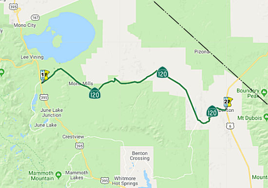 From Route 395 near Mono Lake to Route 6 near Benton Station.
Post 1964 Signage HistoryThis segment is unchanged from its 1963 definition.
Route 120 between US 395 and US 6, while a benign drive in the summer, is
prone to severe snow drifts during the winter. While the western end of
this section sits at about 6800 foot altitude, and the eastern end at
Benton Jct. is even lower at about 5700 feet, the center segment rises to
about 8200 foot elevation -- higher than Conway Summit to the north on US 395. The very lack of variation of the terrain around the highway
contributes to heavy snow drifting during winter months -- there's not
much in the way of steep hills for the snow to fall off -- it tends to
stay packed up on the ground (and the highway); there's nothing stopping
it from "piling on", so to speak. Plowing would be pointless -- by the
time the road was plowed from one end of the snowdrift area to the other,
it would have been overtaken by more drifting in the plow's wake. It's
actually one of the later spring openings on a state highway in that area;
the crews tend to wait until most of the pack has melted off before
plowing it through. The saving grace is that it takes a sizeable snowstorm
to pack it up in the first place, so it's often late November or even
early December before Route 120 is closed in that area.
(Source: Scott Parker (Sparker) at AAroads, 8/2/2016)
Pre 1964 Signage HistoryThis segment was signed as Route 120 in the initial signage of state routes in 1934 (Jct. US 99 at Manteca to Jct. Route 168 (later US 6) at Benton, via Groveland and through Yosemite National Park). It was an extension to LRN 40 defined in 1933.
NamingThe portion of this segment from Route 395 to the site of Mono Mills is named the "Mono Lake Basin Road". It was named by Resolution Chapter 704 in 1917. Mono is derived from the word "Monache," a division of the Shoshonean Indians.
 Classified Landcaped Freeway
The following segments are designated as Classified Landscaped Freeway:
| County | Route | Starting PM | Ending PM |
| San Joaquin | 120 | R0.07 | R4.09 |
| San Joaquin | 120 | R4.54 | R6.33 |
 Interregional Route
 Exit Information
 Other WWW Links
 Statistics
Overall statistics for Route 120:
 Pre-1964 Legislative Route
In 1933, Chapter 767 defined the route "[LRN 2] near Soledad to Pinnacles National Monument and Pinnacles National Monument to Hollister-Priest Valley Road in Bear Valley" as part of the highway system. In 1935, this was codified in the highway code as LRN 120 with the definition:
A 1934 Division of Highways Map shows the eastern segment of LRN 120
(Route 146) running west from Route 25 into Pinnacles National Monument
past the current terminus about a mile to Bear Gulch. The Bear Gulch Road
is pretty much a straight to the western LRN 120 (Route 146) which makes
it likely that this is what the post number gap is based off of. That
means,if the map is correct, there was for a time a less than 2 mile gap
between both segments of LRN 120 (Route 146). The state maps are too
zoomed out really to provide any insight onto when the eastern segment of
Route 120 might have been pulled back to the boundary with Pinnacles
National Monument where the current Route 146 terminus is located. Route 146 in East Pinnacles still retains the same length that it had when it was a National Monument; this is because when the Monument was
expanded to a Park, the boundary was expanded. That left Route 146 East
maintained by Caltrans within the new National Park Boundary. From the
west on Route 146 the highway segment is only 2.45 miles. Despite no
reassurance markers westbound there is a Route 146 END sign at the former
boundary for Pinnacles National Monument. The Eastern Segment of Route 146
has mileage markers ranging from 12.70 to 15.15. Essentially it is a
straight line from the terminus of the western segment across the
Pinnacles which ends at 10.19.
(Source: Tom Fearer (Max R) in AARoads, "CA 146 East", 6/2/2017)
This is the route from US 101 near Soledad to Pinnacles National Monument, and then to Route 25. It is present-day Route 146.
© 1996-2020 Daniel P. Faigin.
Maintained by: Daniel P. Faigin
<webmaster@cahighways.org>.
 Route 119
 Route 121