
 California Highways:
Click here for a key to the symbols used. An explanation of acronyms may be found at the bottom of the page.
 Routing
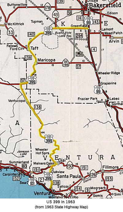 No current routing.
 Pre 1964 Signage History
Until July 1, 1964, the following route was signed as US 399:
The route between US 101 and Taft was conceptualized via an 1890 survey
over Pine Mountain south to Ventura. The 1890 survey was followed by wagon
road being constructed over Pine Mountain to Ventura during 1891. The
communities of Maricopa and Taft organized a "Good Roads Club" in 1911
which led to a political movement to explore upgrading the Pine
Mountain-Ventura Wagon Road to State Highway standards.
(Source: Gribblenation Blog (Tom Fearer), "California State Route 33 and legacy of US Route 399 on the Maricopa-Ventura Highway", August 2021)
In 1913, Chapter 610 declared and established a state highway from the city of Bakersfield through a portion of the counties of Kern, San Luis Obispo, Santa Barbara and Ventura to the city of San Buenaventura, to be designated and known as the "Bakersfield, Maricopa and Ventura state highway." This highway was referenced as:
"A certain highway now partly constructed and partly in the course of construction by the several counties through which the same passes and running substantially along the following lines, courses, and distances: Commencing at a point on the proposed California state highway between Bakersfield and Los Angeles [LRN 4] thence following the present county road W 6 mi, then S 12 mi, thence W ½ mi, thence S ¾ mi, thence W 8 mi, thence SW 4 mi, thence W 5 mi to the town limits of the city of Maricopa, thence ... SW 13 miles to the W boundary of Kern County..., thence from a junction at the Kern Cty line with the proposed road as surveyed by Buffington ... for a distance of approx. 5 mi in the county of San Luis Obispo W about 1 mi through the lands of the Kern Cty Land Company and Cuyama Ranch, thence SW-ly 1½ mi, thence E-ly ¾ mi, thence SE-ly about 1 mi through the lands of the Santa Barbara Forest Reserve and of S.B. Miller, said line of proposed road ... following along the E-ly side of the Cuyama River and in the valley of said Cuyama river to the S border of SLO Cty. Thence from a junction point ... being in Sec. 11 T9N R25W SBM and running in a generally SE-ly direction, following the valley of the Cuyama river for a distance of 8.1 mi to a point in the E boundary of Santa Barbara Cty in Sec 17 T8N R24W SBM. Thence from ... the W boundary of Ventura Cty in the valley of the Cuyama River...beginning at a point in Sec 17 T8 R24W SBM approx. 1100 ft S of the N boundary of Sec 17, thence SE-ly along the NE bank of the Cuyama river a distance of 10 mi to a point near the center of Sec 19 T7N R23W on the S-ly bank of the Cuyama river thence E about ¾ mi to a point in the W half of Sec 20 T7N R23W, thence S through the W half of the W half of Sec 20 T7N R23W, and the W half of the W half of Sec 29 T7N R23W on the E side of Boulder Cyn, thence S on the W side of Boulder Cyn through the E half of the SE qtr of Sec 30 and the W half of Sec 32 T7N R23W, thence SW passing the great saddle rock to a point on the summit of Pine Mtn at the quarter corner between Sec 5 and 6, T6N R23W, thence S along the W side of Chorro Chiquito Cyn through Sec 6, 7, 8 and 18 T6N R23W to the valley of the Sespe River, thence crossing the Sespe River and S up the E side of Cherry Ck Cyn through Sec 19, 30, and 31 T6N R23W to the summit of Ortega Hill in Sec 31 T6N R23W, thence from the top of Ortega Hill and following along the Wheeler Ridge passing through the SW corner of Sec 32 T6N R23W, through the NE corner of Sec 1 T5N R24W, through the center of Sec 6 T5N R23W, to the SE corner of Sec 5 T6N R23W, thence S through Sections 8 and 9 T6N R23W, to a point near the ¼ corner on the S side of Sec 8 T5N R23W, to a point in the Matilja Rd near the Matilja Hot Springs in said Sec 29.... thence SE-ly with the Matilja and Meiners Rds ... to the town of Nordhoff ... thence S-ly with the San Antonio Crk Rd, the Nordhoff Rd, and the Ventura Avenue to the N-ly limits of San Buenaventura."
This segment was adopted into the California Highway System in 1915.
In 1929, Chapter 541 amended this definition to be:
“…is amended to read as follows: A certain highway now partly constructed by the several counties through which the same passes and by joint highway district number six of the State of California and running substantially along the following lines: Commencing at a point in the Cuyama river valley on the state highway running between Santa Maria, Maricopa, and Bakersfield, and known as [LRN 57] of the state highway system, and running thence SE-ly up the Cuyama river valley to a point in Ventura County; thence S-ly over the Coast Range mountains and through the Santa Barbara national forest to Matilja Hot Springs; thence SE-ly to the city of San Buenaventura. The entire length from San Buenaventura (Ventura) to [LRN 57] of the state highway in the Cuyama valley is hereby declared to be, and is hereby constituted, a state highway... provided that said highway shall not become a state highway ... until said highway shall have been fully completed.”
However, both the 1913 and 1929 statutes were repealed in 1935 by the act that created the highway code.
In 1915, Chapter 748 did something similar to the 1913 statute, with an act for the survey, location, and estimate of cost of a state highway from a point on the present located state highway in Kern County S of Bakersfield to the town of Nordhoff, Ventura County. Again, this was repealed in 1935 by the act that created the highway code. It is possible these early routes were LRN 57, but portions may have shown up in the eventual definition of LRN 138 in 1933.
The Maricopa-Ventura Highway opened on October 22, 1933.
The first mention of US 399 is found in a letter by the Division of
Highways to the AASHO Executive Secretary dated September 6, 1934. US 399
appears as a proposed US Route that would connect US 101 to US 99. US 399
is described as having a proposed length of 131 miles beginning from a
south terminus at US 101 in Ventura along with a north terminus at US 99
in Bakersfield.
(Source: Gribblenation Blog (Tom Fearer), "California State Route 33 and legacy of US Route 399 on the Maricopa-Ventura Highway", August 2021)
In the CHPW announcing the 1934 signage of routes, the route that would become US 399 is shown with a US highway shield, but no specific number, and only runs as far as the junction with LRN 57 (Sign Route 166). That map does not show US highway signage on the route into Bakersfield. "399" is not included on the list of routes in that issue, as the list only covers state sign routes.
Signage of the route as US 399 dates back to around 1935.
Prior to the Ojai Freeway, US 399 (possibly co-signed with Sign Route 150) started at US 101 (Thompson Blvd) and S Ventura Avenue. It continued
N up Ventura Avenue in Ojai, to a junction with Baldwin Avenue, where it
met Sign Route 150 entering from the W. There are some reports* that US 399 may have used Nye Road in Casitas Springs; and Sulphur Mtn Rd, and
abandoned loop and/or Creek Rd, or Old Grade Rd in the Oakview area. It it
did, that usage ended by 1936. Note that there is also a section of Old
Ventura Ave starting at Park Ave in Ojai; that is likely an older routing.
(Source: *Mapmikey: The Virginia Highways Project: US Highways: Histories for Mainline, Suffixed, and Bannered Routes: US 399)
A digression: Sign Route 150 appears to have been an interesting hydra in the area, meaning that there possibly were multiple roads signed as Sign Route 150. The main route—that is, the one that appears to correspond with the state highway map—entered from the Santa Barbara area along Casitas Pass Road. As it neared the lake approaching from the W, it made a horseshoe turn and proceeded to cross the lake along a route that is now underwater, veering N to meet Baldwin Road near the SB Santa Ana Road connection. Sign Route 150 then followed Baldwin Road (and Old Baldwin Road) to meet Ventura Avenue. But the USGS maps also show other routes signed as part of Sign Route 150: Notably, a connection (again, now underwater) to Casitas Vista Road (likely a continuation of Casitas Pass Road) that continued to meet Ventura Road, where it continued S into Ventura as a US 399/Sign Route 150 cosign. The pre-lake Sign Route 150 met another road that is now also underwater, continuing to the NE to about where Santa Ana Road is, where it met today's Route 150 at Baldwin Road. That same USGS map also shows Sign Route 150 running from the Ventura Road/Santa Ana Road junction along Santa Ana Road and Burnham Road to Baldwin Road. The USGS maps are notorious for sometimes showing roads as signed that weren't, but as it was the ACSC that was doing the signing and numbers were less significant to folks, there were often spurs or alternates signed with the number. However, it is clear that Sign Route 150 shared US 399 between Baldwin Road and Ojai Avenue, split back off on its lonesome to the E along Ojai Avenue as solely Sign Route 150.
After the Ojai Freeway was constructed in the early 1950s, the routing in Ventura changed. By 1956, US 399 was using a connector that started near N. Thompson and Main (US 101) near N Garden, which went diagonally to pick up the Ojai Freeway near Park Row Avenue (Note that S. Garden was the US 101 connector between Thompson and W Main before the freeway). That connector was modified with the construction of the Mission Plaza Shopping Center; it now starts off of N Olive below Rex Street, providing accessibility to the Ojai Freeway (now Route 33, nee US 399) from W. Main (which was US 101). After the freeway portion of the Ojai Freeway ends heading N (see the page on Route 33), the road downgrades into Ventura Avenue.
In 1955, planning for the first 4 miles of the Ojai Freeway was nearing
completion. The Ojai Freeway was slated to be a realignment of US 399/LRN 138 off of Main Street and Ventura Avenue in the City of the Ventura. In
1956, the first 4.1 miles of the Ojai Freeway opened as a realignment of
US 399/LRN 138. The first segment of the Ojai Freeway began at US 101/LRN 2 on West Main Street near downtown Ventura. There was a planned
interchange to intersect the Ventura Freeway when it was extended through
Ventura. By the end of 1962, the Ventura Freeway through the City of
Ventura was completed (opening during late October 1962). This served to
remove US 101/LRN 2 from Main Street/Garden Street/Thompson Boulevard
through the City of Ventura. moving the connection with the Ojai
Freeway/US 399 to an interchange structure. The original plans were to
extend the Ojai Freeway to Route 150, but that never came to fruition.
(Source: Gribblenation Blog (Tom Fearer), "California State Route 33 and legacy of US Route 399 on the Maricopa-Ventura Highway", August 2021)
In December 1956, US 399 was moved to the first part of the new Ojai
Freeway to open, out of Ventura to the first Ventura Ave overpass. The
freeway started at the Main St/S. Garden (now Business Route 101) and headed NW past
Olive Street and past what are now the ramps for the Main St exit.
(Source: Mapmikey: The Virginia Highways Project: US Highways:
Histories for Mainline, Suffixed, and Bannered Routes: US 399)
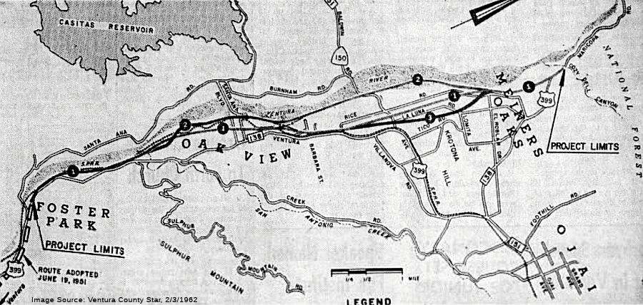 In 1962, it was reported that the the proposals for Ojai Freeway routings through
Foster Park, Oakview, and Meiners Oaks had been narrowed to three basic
locations, with alternate jogs bringing the total to six. The DOH intended
to widen Route 150 from its junction with the new freeway to Ojai's W city
limits, creating a four-lane road at a cost of $200,000. Route 1 would run
E of the river through Oak View and through Mira Monte between La Luna and
Rice Roads to a junction with US 399 at Cozy Dell Canyon. Option 2, the
least expensive, would follow the Ventura River all the way to the same
terminus. Option 3 would be the same as Option 1 through Oak View but
would swing E to a line between La Luna and Tico Roads, then back towards
the river to the terminus. All routes would closely follow the railroad
tracks through Casitas Springs. The Creek Road route that was proposed in
1959 was abandoned. A total of 211 families would be affected by proposed
Option 1, at a cost of 14.9 milllion; Option 2 would affect 112 families
and cost $12.3 million, and Option 3 would affect 190 families and cost
$15.3 million. This proposal never came to fruition, and the Ojai section
of the freeway was deleted from the project.
In 1962, it was reported that the the proposals for Ojai Freeway routings through
Foster Park, Oakview, and Meiners Oaks had been narrowed to three basic
locations, with alternate jogs bringing the total to six. The DOH intended
to widen Route 150 from its junction with the new freeway to Ojai's W city
limits, creating a four-lane road at a cost of $200,000. Route 1 would run
E of the river through Oak View and through Mira Monte between La Luna and
Rice Roads to a junction with US 399 at Cozy Dell Canyon. Option 2, the
least expensive, would follow the Ventura River all the way to the same
terminus. Option 3 would be the same as Option 1 through Oak View but
would swing E to a line between La Luna and Tico Roads, then back towards
the river to the terminus. All routes would closely follow the railroad
tracks through Casitas Springs. The Creek Road route that was proposed in
1959 was abandoned. A total of 211 families would be affected by proposed
Option 1, at a cost of 14.9 milllion; Option 2 would affect 112 families
and cost $12.3 million, and Option 3 would affect 190 families and cost
$15.3 million. This proposal never came to fruition, and the Ojai section
of the freeway was deleted from the project.
(Source: Ventura County Star, 2/3/1962 via email from Will
Poundstone. 1/1/2024)
Between Baldwin Avenue and Ojai Avenue, US 399 was co-signed with Sign Route 150. Sign Route 150 split off at Ojai Ave, and US 399 continued along Maricopa Avenue which turned into Maricopa Highway, now Route 33.
Near Ojala (near Matilijia Lake), around 1949, US 399 was removed from
the lower part of the Ojala Quarry driveway; and around 1953, US 399 was
removed from the driveway to 15275 Hwy 33 south of Ojala, which no longer
connects back up with Route 33.
(Source: Mapmikey: The Virginia Highways Project: US Highways:
Histories for Mainline, Suffixed, and Bannered Routes: US 399)
By 1931, the three Matilija Tunnels on LRN 138 in Wheeler Gorge had been
completed. Construction continued in 1934 along LRN 138 from Ventura to
LRN 57 in Cuyama Valley, along an alignment following; Ojai Valley,
Wheeler Gorge, the Sespe Gorge and Pine Mountain.
(Source: Gribblenation Blog (Tom Fearer), "California State Route 33 and legacy of US Route 399 on the Maricopa-Ventura Highway", August 2021)
Maricopa Highway continued as US 399 (today's Route 33) to a point E of Cuyama Ranch, where it met Sign Route 166 and continued co-signed to the NE (this is today a Route 33/Route 166 cosign, legislatively Route 33) into Maricopa. In Maricopa, Sign Route 166 continued to the E along Maricopa Highway, while US 399 continued (potentially cosigned with Sign Route 33) N along California St. This later became today's West Side Highway; it is unclear the former name of the road.
In the period between 1934 and 1938 between the outskirts of Maricopa and
Taft, US 399 originally used Petroleum Club Road. This corridor was
constructed as a frontage road of the Sunset Railroad and would be the
site of the Lakeview Gusher in 1910. In January 1938, US 399 was moved to
the current West Side Highway routing. Within Taft, before 1935, US 399
used Wood St. to abandoned route north that is now a parking lot adjacent
to West Kern Oil Museum, to today's Taft Bypass, to Center St. or Main St,
to 1st St to Kern St.to 6th St/Harrison St. In May
1935, US 399 was given a more direct routing through Taft using West Side
Hwy, Kern St, and 6th St/Harrison St.
(Source: Mapmikey: The Virginia Highways Project: US Highways:
Histories for Mainline, Suffixed, and Bannered Routes: US 399; Gribblenation Blog, "Petroleum Club Road (former California State Route 33 and US Route 399 past the Lakeview Gusher)", 5/6/2026)
Within Taft, US 399 originally ran along 6th Street/Harrison
Street, with Sign Route 33 splitting off at San Emigdio Street. Later, the
route was adjusted to have Sign Route 33 continue on Kern Street. This
happened in 1935, when Sign Route 33 (LRN 138) was realigned through Taft.
The then new alignment was constructed onto two extensions of Kern Street
on both sides of downtown. The multiplex of US 399 and Sign Route 33 was
realigned to meet at Kern Street and 6th Street.
(Source: Gribblenation Blog, "Petroleum Club Road (former California State Route 33 and US Route 399 past the Lakeview Gusher)", 5/6/2026)
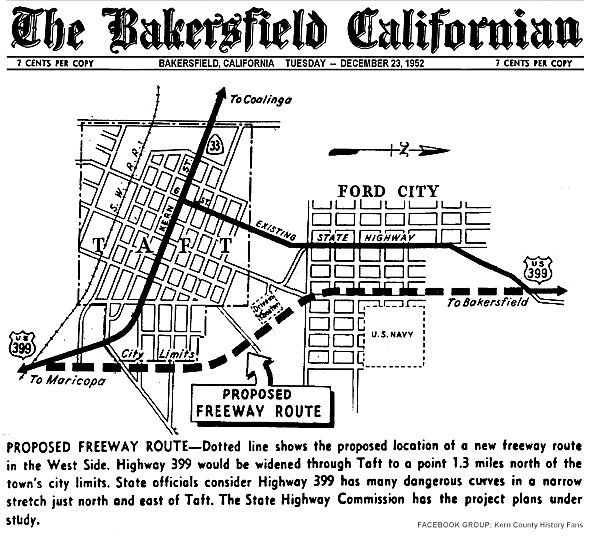 In 1952, a freeway alignment was adopted for US 399 (now Route 33 and Route 119)
through Taft. The plan was to widen US 399 through Taft to a point 1.3mi N
of the town's city limits. Project plans were under study The bypass was
constructed in 1956. Subsequent discussion on the Facebook post where this
map was posted indicated that the final adopted routing differed slightly
from the routing shown. Specifically, the proposed route seems to show the
new routing running along Monroe St, whereas the actually routing runs
about 6-7 blocks to the E, running straight to the N and curving back
after passing what is shown as the US Navy land in the diagram. In any
case, by 1956, US 399 was using the alignment used by today's Route 119:
veering off the West Side Highway/Kern Street at Taft Highway. It merges
with the old alignment, Harrison St. just N of the town of Taft in a
community called Ford City. Note that Harrison Street continues NE after
the first merge to meet Taft Highway again, at a point E of Elk Hills
Road; that portion of Harrison Street was the original US 399 prior to the
Taft Highway realignment.
In 1952, a freeway alignment was adopted for US 399 (now Route 33 and Route 119)
through Taft. The plan was to widen US 399 through Taft to a point 1.3mi N
of the town's city limits. Project plans were under study The bypass was
constructed in 1956. Subsequent discussion on the Facebook post where this
map was posted indicated that the final adopted routing differed slightly
from the routing shown. Specifically, the proposed route seems to show the
new routing running along Monroe St, whereas the actually routing runs
about 6-7 blocks to the E, running straight to the N and curving back
after passing what is shown as the US Navy land in the diagram. In any
case, by 1956, US 399 was using the alignment used by today's Route 119:
veering off the West Side Highway/Kern Street at Taft Highway. It merges
with the old alignment, Harrison St. just N of the town of Taft in a
community called Ford City. Note that Harrison Street continues NE after
the first merge to meet Taft Highway again, at a point E of Elk Hills
Road; that portion of Harrison Street was the original US 399 prior to the
Taft Highway realignment.
(Source: Art Moore on FB, 12/22/2022, sharing map from the Bakersfield Californian, 12/23/1952)
US 399 continued E along Taft Highway. Near the community of Tupman (N Coles Oil Field), US 399 originally veered off along today's Golf Course Road and Tupman Road (now Golf Course Road, until it crosses Taft Highway and becomes Tupman again). That loop was cut off by the construction of Taft Highway. US 399 continued along Taft Highway into Greenfield, where it met US 99.
The original route of US 99 used Union/19th/Chester through
downtown Bakersfield. In June 1934, US 99 was rerouted in Bakersfield to
use Union to Golden State Ave. It is unclear if US 399 even entered
Bakersfield solely as US 399. If it did, it would have run from Taft
Highway to where it meets Stine Road (Taft Highway may have been Panama
Road at this time). It then would have run a connection with Wilson Road,
then E to Wible Road, N to Bell Terrace, E to Oleander Ave, N on Oleander
to Brundage Lane, E on Brundage to Chester, and then N on Chester to 19th/Chester,
where it would have ended with US 466. However, that route does not appear
to have been a legislative route; but then again, before 1935 the state
did not define specific routes within cities. As US 99 was later removed
from downtown, the timing of that removal would have been when US 399 was
changed to follow Taft Hwy to US 99 in Greenfield, then north co-signed
with US 99 to likely end at US 466 (Golden State Ave at Sumner St).
However, it is extremely unlikely US 399 was posted on the solo approach,
if it went that way at all.
(Source: Mapmikey: The Virginia Highways Project: US Highways:
Histories for Mainline, Suffixed, and Bannered Routes: US 399)
Note that it could well be that the route of US 399 was not defined prior to 1935 in the vicinity of Bakersfield. This is because prior to 1935, the state did not maintain highways within major cities. According to Nathan Edgers, the 1924 state highway map shows LRN 57 on a zigzag route into Bakersfield, partly marked "paved by local authorities - not taken over by state"; the local-built part in 1924 appears to be Stine Road, Wilson Road (?), and Wible Road, which fits with the description above. Note that the 1924 routing (shown as "authorized, not taken over by state") does not appear to go through Taft or Tupman, but instead follows the railroad from Maricopa through Gosford to Bakersfield. State maps are a bit inconsistent in this time period regarding the routing through Taft and Tupman. The 1926 shows a route straight from Maricopa to US 99, and no route through Taft or Tupman, and it doesn't show the 1924 routings. The 1928 shows something similar, although the route from Maricopa to US 99 is an unimproved road. The 1930 shows a new route that runs to Taft (and continues to McKittrick and on to Coalinga, although unimproved, which is likely future Sign Route 33); and the route from Taft continues NE and over the top of the Buena Vista Lake Reservoir to meet US 99; there is also a bit more zig-zaggy route that runs up to future Sign Route 178. But those routes don't show on the 1932 map. They reappear, with more improvements, in the 1934 state highway map. By the 1935 map, US 399 is shown, and it is co-signed into Bakersfield along US 99.
The 1936-37 Division of Highways Map shows US 399 (defined in 1934)
co-signed with US 99 on Golden State Avenue. US 399 is shown to multiplex
US 99 from Greenfield into downtown Bakersfield via Union Avenue where it
would have terminated at US 466. In 1957, US 99/US 466/LRN 4 on Golden
State Avenue was relocated to an overpass of the Garces Traffic Circle.
Connection to LRN 142/Chester Avenue would be made from the US 99/US 466/LRN 4 overpass via frontage roads. The first units of the Bakersfield
Bypass freeway routing were funded in 1960-1961, and opened in 1962. US 99
moved to the "West Bakersfield" freeway in 1963. The West Bakersfield
Freeway saw the relinquishment of Union Avenue south of Brundage Lane/LRN 141, which truncated US 399 out of Bakersfield to US 99 at Pumpkin Center
on Taft Highway.
(Source: Gribblenation Blog (Tom Fearer), “California State Route 204; former US Route 99, US Route 399 and US Route 466 in Bakersfield”, April 2021)
In 1962, the portion of US 399 in Bakersfield was later relegated to Business Loop status in 1962, and became Business Route 99/Route 204 in 1964. However, the portion of former US 399 south of Brundage Lane (current parallel street to Route 58, the replacement for US 466) was removed from the state route in 1978; only the portion of former US 99 on Union Avenue from Golden State Avenue/Sumner Street south to Route 58 remains in the state system as Route 204. All of the route remains part of Business Route 99.
On May 1, 1963, the Division of Highways submitted a request to the AASHO
Executive Committee to remove US 399 as part of the planned 1964
California State Highway Renumbering. This request was considered by the
AASHO Executive Committee on June 19, 1963 and met with their approval. US 399 subsequently would effectively cease to exist as of 1/1/1964. US 399
was replaced by Route 119 from Bakersfield to Taft and by a realigned
Route 33 from Maricopa via the Ventura-Maricopa Highway to Ventura
(including a co-signed portion with Route 166).
(Source: Gribblenation Blog (Tom Fearer), "California State Route 33 and legacy of US Route 399 on the Maricopa-Ventura Highway", August 2021)
With the decommissioning of US 399, Ventura to Taft became Route 33 (and
is still Route 33 today except that the diagonal arterial between Main
St/S Garden St in Ventura was torn out, leaving only the ramps to/from
Olive St to Ojai Freeway). There is also supposedly an abandoned diagonal
in Maricopa between Alameda St and the Route 33/Route 166. Additionally,
with the decomissioning, Taft to Greenfield became Route 119 (although, as
noted above, there was a rerouting off Golf Course Rd north of Dustin
Acres).
(Source: Mapmikey: The Virginia Highways Project: US Highways:
Histories for Mainline, Suffixed, and Bannered Routes: US 399)
 Other WWW Links
© 1996-2024 Daniel P. Faigin.
Maintained by: Daniel P. Faigin
<webmaster@cahighways.org>.
 Route 395
 Route 404