
 California Highways:
Click here for a key to the symbols used. An explanation of acronyms may be found at the bottom of the page.
 Routing
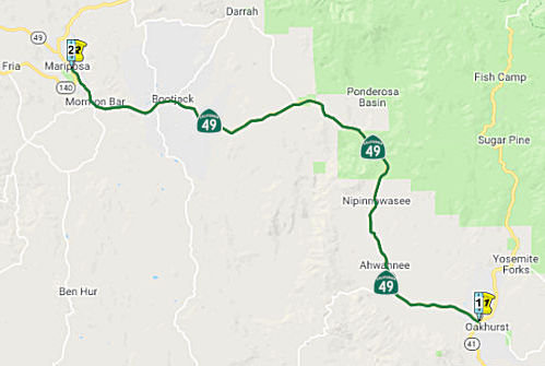 (a) (1) From Route 41 near
Oakhurst to Route 140 at Mariposa.
(a) (1) From Route 41 near
Oakhurst to Route 140 at Mariposa.
 Post 1964 Signage History
As defined in 1963, this segment was part of a larger segment running from "Route 41 near Oakhurst to Route 120 near Moccasin Creek." In 1984, Chapter 409 split this into two segments: "(a) Route 41 near Oakhurst to Route 140 at Mariposa. (b) Route 140 at Mariposa to Route 120 near Moccasin."
 Pre 1964 Signage History
Before 1964, this was a proposed route with routing determined. It was an extension of LRN 65 defined in 1959. This was not part of the original 1934 state signage of Route 49.
Tom Fearer, on the Gribblenation Blog, has an excellent summary of this historical routings of Route 49. His site includes a lot of maps that I won't reproduce here illustrating past routings as the specific routing of Route 49 has changed over the years.
 It appears that, in 1961, there were two alternatives
considered for the freeway routing between Oakhurst and Mariposa. These
were considered in June 1961. It appears that Alternative 1 was chosen
It appears that, in 1961, there were two alternatives
considered for the freeway routing between Oakhurst and Mariposa. These
were considered in June 1961. It appears that Alternative 1 was chosen
(Source: Joel Windmiller, via Mariposa History and
Pictures FB Group)
 In 1975, the CHC published a notice of intent to abandon
the adopted freeway routing between Route 41 and 0.4 mi S of the Madera
County Line. The stated reason was lack of funds and no plans to construct
the freeway in the foreseeable future.
In 1975, the CHC published a notice of intent to abandon
the adopted freeway routing between Route 41 and 0.4 mi S of the Madera
County Line. The stated reason was lack of funds and no plans to construct
the freeway in the foreseeable future.
(Source: Fresno Bee, 11/26/1975, via Joel Windmiller, 2/25/2023)
 Status
In May 2021, it was reported that Caltrans will improve driving
conditions by repairing and repaving Route 49 from the Mariposa/Madera
county line to the Route 49/Route 140 south junction in Mariposa (~ MPA
0.00 to MPA 18.479). The $20.75 million project – awarded to
Teichert Construction of Roseville, CA – is scheduled to begin in
May 2021 and continue until winter 2021. Once completed, 34.6 lane miles
of roadway will be rehabilitated and freshly repaved. The project also
includes restriping the roadway, installing rumble strips, and repairing
guard rails.
(Source: Sierra Sun Times, 5/4/2021)
In October 2018, it was reported that the CTC approved funding for
preventative repair work on the Stockton Creek Bridge (MPA 017.20, Bridge
40-0021) on Route 49.
(Source: Sierra Sun Times, October 2018)
 Named Structures
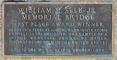 Bridge 40-0048, at the east fork of the Chowchilla River in Mariposa county (MPA 002.87), is named the "William M. Sell Memorial
Bridge". It was built in 1972, and was named by Assembly Concurrent
Resolution 22, Chapter 46, the same year. William Martin Sell, Jr.,
(1882-1971), a lifetime resident of the Sierra and hostler, served on the
Madera County Board of Supervisors.
Bridge 40-0048, at the east fork of the Chowchilla River in Mariposa county (MPA 002.87), is named the "William M. Sell Memorial
Bridge". It was built in 1972, and was named by Assembly Concurrent
Resolution 22, Chapter 46, the same year. William Martin Sell, Jr.,
(1882-1971), a lifetime resident of the Sierra and hostler, served on the
Madera County Board of Supervisors.
(Image Source: Mariposa County Historical Sites Interactive Map Tour)
 Scenic Route
[SHC 263.4] Entire portion.
 Freeway
[SHC 253.4] Entire portion. Added to the Freeway and Expressway system in 1959.
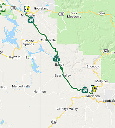 (2) From Route 140 at Mariposa to Route 120 near Moccasin.
Post 1964 Signage HistoryAs defined in 1963, this segment was part of a larger segment running from "Route 41 near Oakhurst to Route 120 near Moccasin Creek." In 1984, Chapter 409 split this into two segments: "(a) Route 41 near Oakhurst to Route 140 at Mariposa. (b) Route 140 at Mariposa to Route 120 near Moccasin."
Pre 1964 Signage HistoryIn 1934, Route 49 was signed along the route from Jct Route 140 at Mariposa to Jct. Route 24 (now Route 70) near Reno Jct, via Sonora, Jackson, and Nevada City. It was part of a 1933 extension of LRN 65.
Originally when Route 49 was originally signed in 1934 the southern
terminus was in Mariposa at Route 140. In 1960 there appears to have been
an adopted alignment extension of LRN 65 (which Route 49 ran on) from
Mariposa to Oakhurst which can be seen looking at the 1959 and 1960 State
Highway Maps.
(Source: Tom Feaerer (Max R) on AARoads, June 2017)
Bagby (~ MPA R34.524)
Bagby was a small community located on the original
alignment of Route 49 at the bottom of the Merced River Canyon of Mariposa
County. The community of Bagby was located on the historic Merced
River crossing of Ridley's Ferry and was for a time a siding of the
Yosemite Valley Railroad. Bagby was bypassed by a new alignment of
Route 49 during 1966 as the site was being prepared to be inundated due to
the expansion of Lake McClure. In 1933, LRN 65 (signed as Route 49 in
1935) was extended from Moccasin south to Mariposa. The expansion of
LRN 65 incorporated the Merced River Canyon Road through Bagby as a State
Highway. During 1945, the Yosemite Valley Railroad went defunct that left
only Route 49 as the only mode of transportation through Bagby. In 1965, a
0.7-mile relocation of Route 49 was announced that would bypass
Bagby. The relocation of Route 49 was deemed to be necessary due to
the expansion of Exchequer Dam that would inundate the site of
Bagby. During 1966, the new Merced River Bridge opened as the bypass
alignment of Route 49 around Bagby. Bagby would be razed to make way
for an expanded Lake McClure during late year 1966. New Exchequer
Dam would be completed during 1967 and would begin to flood the site of
Bagby.
(Source: Gribblenation Blog (Tom Fearer), "Former California State Route 49 through Bagby", 12/2022)
StatusIn late May 2018, it was reported that Caltrans has opened northbound and
southbound Route 49 from the Tuolumne/Mariposa County line (MPA 48.835/TUO
0.0) to Moccasin/Route 120 (~ TUO R6.427) in Tuolumne County following a
long-term closure since violent storms whipped through the region on March
22, causing hillslides and heavy flooding in parts of Tuolumne and
Mariposa counties. Route 49 in Tuolumne County will have periodic one-way
traffic controls for culvert work through June 2018. Repair work on Route 49 in Tuolumne County is estimated at $2.5 million to $3 million. Severe
damage from the storm also forced Route 49 in northern Mariposa County and
Route 132 in eastern Stanislaus County to close. While the deluge undercut
sections of the roadway and destroyed culverts on both sections of Route 49, it carried away a 60-foot section of Route 132. Route 132 opened
Friday, May 18, while Route 49 in Mariposa County (Bear Valley Road (~ MPA
29.509) to Coulterville (~MPA 44.698)) is scheduled to open later in
summer 2018.
(Source: Sierra Sun Times, 5/24/2018)
Scenic Route[SHC 263.4] Entire portion.
Named Structures Between PM MPA 30.5 and MPA 31.0 is the "General John Fremont Historical Plaque". It was named by Assembly
Concurrent Resolution 145, Chapter 143, in 1994. General John Fremont was
born in Savannah, Georgia, on January 21, 1813. He was a teacher of
mathematics, and an engineer in the U. S. Topographical Corps. He was
involved in many significant explorations and events outside of
California. In the mid 1840s, he was exploring the area around the Great
Salt Lake. After leaving Great Salt Lake, he explored the upper
tributaries of the Columbia, descended the valley of that River to Fort
Vancouver, near its mouth, and on 10 November set out on his return. His
route lay through an almost unknown region leading from the Lower Columbia
to the Upper Colorado, and was crossed by high and rugged mountain chains.
Deep snow soon forced him to descend into the great basin, and he
presently found himself, in the depth of winter, in a desert, with the
prospect of death to his whole party from cold and hunger. By astronomical
observation he found that he was in the latitude of the bay of San
Francisco; but between him and the valleys of California was a snow clad
range of mountains. Fremont undertook the passage without a guide, and
accomplished it in forty days, reaching Sutter's Fort, on the Sacramento,
early in March with his men reduced almost to skeletons, and with only
thirty-three out of sixty-seven horses and mules remaining. He continued,
through various expeditions, to explore the great basin and the maritime
region of Oregon and California. At one point, he was ordered to leave
California by the Mexican authorities, and refused to comply. The Mexican
commander, General José Castro, then mustered the forces of the
province and prepared to attack the Americans, who numbered only
sixty-two. Fremont took up a strong position near Monterey, built a rude
fort of felled trees, hoisted the American flag, and, having plenty of
ammunition, resolved to defend himself. After four days of siege, General
Castro proposed a cessation of hostilities. On 9 May 1846, he met a party
in search of him with dispatches from Washington, directing him to watch
over the interests of the United States in California, there being reason
to apprehend that the province would be transferred to Great Britain, and
also that General Castro intended to destroy the American settlements on
the Sacramento. In less than a month he had freed Northern California from
Mexican authority. He received a lieutenant colonel's commission on 27
May, and was elected governor of California by the American settlers on 4
July. On 13 January 1847, Fremont concluded with the Mexicans articles of
capitulation, which terminated the war in California and left that country
permanently in the possession of the United States. After even more
events, he was elected as Senator from California, and later ran for
President against James Buchanan. At the time of the Civil War, he was
made a Major General in command of the Western Department.
Between PM MPA 30.5 and MPA 31.0 is the "General John Fremont Historical Plaque". It was named by Assembly
Concurrent Resolution 145, Chapter 143, in 1994. General John Fremont was
born in Savannah, Georgia, on January 21, 1813. He was a teacher of
mathematics, and an engineer in the U. S. Topographical Corps. He was
involved in many significant explorations and events outside of
California. In the mid 1840s, he was exploring the area around the Great
Salt Lake. After leaving Great Salt Lake, he explored the upper
tributaries of the Columbia, descended the valley of that River to Fort
Vancouver, near its mouth, and on 10 November set out on his return. His
route lay through an almost unknown region leading from the Lower Columbia
to the Upper Colorado, and was crossed by high and rugged mountain chains.
Deep snow soon forced him to descend into the great basin, and he
presently found himself, in the depth of winter, in a desert, with the
prospect of death to his whole party from cold and hunger. By astronomical
observation he found that he was in the latitude of the bay of San
Francisco; but between him and the valleys of California was a snow clad
range of mountains. Fremont undertook the passage without a guide, and
accomplished it in forty days, reaching Sutter's Fort, on the Sacramento,
early in March with his men reduced almost to skeletons, and with only
thirty-three out of sixty-seven horses and mules remaining. He continued,
through various expeditions, to explore the great basin and the maritime
region of Oregon and California. At one point, he was ordered to leave
California by the Mexican authorities, and refused to comply. The Mexican
commander, General José Castro, then mustered the forces of the
province and prepared to attack the Americans, who numbered only
sixty-two. Fremont took up a strong position near Monterey, built a rude
fort of felled trees, hoisted the American flag, and, having plenty of
ammunition, resolved to defend himself. After four days of siege, General
Castro proposed a cessation of hostilities. On 9 May 1846, he met a party
in search of him with dispatches from Washington, directing him to watch
over the interests of the United States in California, there being reason
to apprehend that the province would be transferred to Great Britain, and
also that General Castro intended to destroy the American settlements on
the Sacramento. In less than a month he had freed Northern California from
Mexican authority. He received a lieutenant colonel's commission on 27
May, and was elected governor of California by the American settlers on 4
July. On 13 January 1847, Fremont concluded with the Mexicans articles of
capitulation, which terminated the war in California and left that country
permanently in the possession of the United States. After even more
events, he was elected as Senator from California, and later ran for
President against James Buchanan. At the time of the Civil War, he was
made a Major General in command of the Western Department.
(Source: Biography of General Fremont; Image Source: NoeHill Travels, American Battlefield Trust)
 Near Mormon Creek, there is the "Mormon Battalion Historical Plaque" (TUO 14.737), named by Senate Concurrent Resolution 40, Chapter 95, in 1995. The Morman Battalion was a
battalion of 500 Mormons under command of Col. (later General) Stephen W.
Kearney, Commander of the Army of the West. They were a key element in the
Mexican-American War that resulted in the liberation of California from
Mexican Rule. In 1846 this infantry battalion made the longest march in
United States Army history, 2.400 miles, from Council Bluffs, Iowa to San
Diego, California, to assist in the military defeat of Mexico.
Near Mormon Creek, there is the "Mormon Battalion Historical Plaque" (TUO 14.737), named by Senate Concurrent Resolution 40, Chapter 95, in 1995. The Morman Battalion was a
battalion of 500 Mormons under command of Col. (later General) Stephen W.
Kearney, Commander of the Army of the West. They were a key element in the
Mexican-American War that resulted in the liberation of California from
Mexican Rule. In 1846 this infantry battalion made the longest march in
United States Army history, 2.400 miles, from Council Bluffs, Iowa to San
Diego, California, to assist in the military defeat of Mexico.
(Image source: Historical Marker Database)
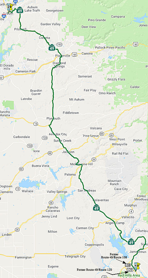 (3) From Route 120 near Chinese Camp to Route 80 near Auburn
via the vicinity of Sonora; via Angels Camp, San Andreas, and Jackson; and
via the vicinity of El Dorado, Diamond Springs, and Placerville.
(3) From Route 120 near Chinese Camp to Route 80 near Auburn
via the vicinity of Sonora; via Angels Camp, San Andreas, and Jackson; and
via the vicinity of El Dorado, Diamond Springs, and Placerville.
(b) The relinquished former portion of Route 49 within the City of Auburn is not a state highway and is not eligible for adoption under Section 81. For the relinquished former portion of Route 49, the City of Auburn shall maintain within its jurisdiction signs directing motorists to the continuation of Route 49. The city may apply to the department for approval of a business route designation in accordance with Chapter 20, Topic 21, of the Highway Design Manual.
Post 1964 Signage HistoryAs defined in 1963, this was a single segment running from "Route 120 to Route 20 via Sonora, Angels Camp, San Andreas, Jackson, El Dorado, Diamond Springs, Placerville, and Auburn." Before the year was out, this was split into two segments by Chapter 1698: "(b) Route 120 to Route 80 in Auburn via the vicinity of Sonora; via Angels Camp, San Andreas, and Jackson; via the vicinity of El Dorado, Diamond Springs, and Placerville. (c) Route 80 near Auburn to Route 20."
In 1965, Chapter 1372 changed the wording further to "Route 120 near Chinese Camp to Route 80 in Auburn via the vicinity of Sonora; via Angels Camp, San Andreas, and Jackson; via the vicinity of El Dorado, Diamond Springs, and Placerville." This change has the side effect of transferring the former segment of cosigned Route 108/Route 49 between Yosemite Junction NE to Route 49 formally to Route 108, and to eliminate the cosigning of Route 120 with Route 49 from Route 49 near Chinese Camp NW to Yosemite Junction.
In 1968, Chapter 282 changed the terminus to "Route 80 near Auburn".
According to Joe Rouse, the segment of Route 49 from Moccasin to Chinese
Camp was supposed to be part of a four-lane freeway/expressway facility on
Route 120 from Oakdale to (he thinks) somewhere near Groveland. This would
have included a replacement of New Priest Grade. Because it's built to
two-lane expressway standards, the speed limit is higher. The James Robert
Bridge across Lake Don Pedro was built to accommodate four lanes; as a
result, the piers are wider than the structure itself with Y-shaped bent
caps that now only support one set of lanes.
(Source: Joe Rouse on AAroad, 9/10/2016)
 In 1968, the CHC began discussing proposals for the Sonora Bypass. The 6.1 mi
section, a combination of Route 49 and Route 108, extends from 0.4 mi W of
Mooney Road S of Jamestown to 1.1 mi E of Sonora. The recommended
alternative was designated as A-2. It leaves the alignment of existing
Route 49 0.5 N of Mooney Road to run due N for about a mile. It then turns
NE, recrossing the existing highway N of Jamestown and continuing to near
the SW corner of Sonora. It then jogs E to pass 0.5 mi S of Sonora before
turning generally NE again to join a previously adopted freeway at
existing Route 108 immediately E of Pine Road. The plan is for a scenic
expressway, not a freeway, at this point. Route A-1, the other proposal,
was identical to A-2 from the western start for more than half the total
route distance, splitting a half-mile east of Volponi Acres at Mill Villa
Hill, where A-2 heads S to join up with Route B, near Campo Seco Road.
Route A-1 at Mill Villa Hill jogs S of the existing highway and passes
through the southern edge of Sonora, crossing Washington and Stewart Sts.
on a 40' high overpass. Route B immediately heads S after crossing the
Jacksonville Road generally paralleling Campo Seco Road.
In 1968, the CHC began discussing proposals for the Sonora Bypass. The 6.1 mi
section, a combination of Route 49 and Route 108, extends from 0.4 mi W of
Mooney Road S of Jamestown to 1.1 mi E of Sonora. The recommended
alternative was designated as A-2. It leaves the alignment of existing
Route 49 0.5 N of Mooney Road to run due N for about a mile. It then turns
NE, recrossing the existing highway N of Jamestown and continuing to near
the SW corner of Sonora. It then jogs E to pass 0.5 mi S of Sonora before
turning generally NE again to join a previously adopted freeway at
existing Route 108 immediately E of Pine Road. The plan is for a scenic
expressway, not a freeway, at this point. Route A-1, the other proposal,
was identical to A-2 from the western start for more than half the total
route distance, splitting a half-mile east of Volponi Acres at Mill Villa
Hill, where A-2 heads S to join up with Route B, near Campo Seco Road.
Route A-1 at Mill Villa Hill jogs S of the existing highway and passes
through the southern edge of Sonora, crossing Washington and Stewart Sts.
on a 40' high overpass. Route B immediately heads S after crossing the
Jacksonville Road generally paralleling Campo Seco Road.
(Source: Newspaper Article dated 1/18/1968 via Joel Windmiller,
2/16/2023)
In 2008, Chapter 635 (AB 1915, 9/30/2008) authorized the relinquishment of the portion within the city limits of the city of Auburn, with the usual terms and conditions language:
(1) The commission may relinquish to the City of Auburn the portion of Route 49 that is located within the city limits of that city, upon terms and conditions the commission finds to be in the best interests of the state, if the department and the city enter into an agreement providing for that relinquishment.
(2) A relinquishment under this subdivision shall become effective immediately following the county recorder's recordation of the relinquishment resolution containing the commission's approval of the terms and conditions of the relinquishment.
(3) On and after the effective date of the relinquishment, the relinquished portion of Route 49 shall cease to be a state highway.
(4) The portion of Route 49 relinquished under this subdivision shall be ineligible for future adoption under Section 81.
(5) For the portion of Route 49 that is relinquished under this subdivision, the City of Auburn shall maintain within its jurisdiction, signs directing motorists to the continuation of Route 49. The city may apply to the department for approval of a business route designation in accordance with Chapter 20, Topic 21, of the Highway Design Manual.
The portion within Auburn was relinquished in May 2009.
In September 2012, AB 2679, Chapter 769, updated the text to recognize that the portion had been relinquished.
SB 788 (Chapter 525, 10/9/2013) Delted the relinquishment wording to eliminate the requirement for continuity of traffic flow:
(b) The relinquished former portion of Route 49 within the City of Auburn is not a state highway and is not eligible for adoption under Section 81. For the relinquished former portion of Route 49, the City of Auburn shall maintain within its jurisdiction signs directing motorists to the continuation of Route 49and shall ensure the continuity of traffic flow on the relinquished portion of Route 49, including any traffic signal progression. The city may apply to the department for approval of a business route designation in accordance with Chapter 20, Topic 21, of the Highway Design Manual.
Pre 1964 Signage HistoryIn 1934, Route 49 was signed along the route from Jct Route 140 at Mariposa to Jct. Route 24 (now Route 70) near Reno Jct, via Sonora, Jackson, and Nevada City. Between Chinese Camp and Sonora, a different route is used. Picture a triangle:
Between Route 120 and Route 108 S of Jamestown, this was a new routing for Route 49 defined in 1965. Between Route 108 S of Jamestown and Route 108 near Sonora, this was LRN 13 (1910). Between Route 108 near Sonora and US 50, Route 49 was LRN 65, defined in 1933. The segment between US 50 and I-80 was defined in 1921.
Jacksonville (Former Route 49: ~ Route 120 TUO R19.352)
Jacksonville was a California Gold Rush mining
community located on the Tuolumne River of southwest Tuolumne
County. The original alignments of Sign Route 49 and Sign Route 120
both once passed through the town site of Jacksonville. Jacksonville
was razed during 1967-71 to make way for the expanded Don Pedro Lake which
inundated the town site.
(Source: Gribblenation Blog (Tom Fearer), "Former California State Route 49 and California State Route 120 through Jacksonville", 7/13/2023)
In 1853 the Grizzly Gulch Trail was declared a public
highway by Tuolumne County. By 1859, a new highway was completed
along the southern flank of Grizzly Gulch as a franchise toll road.
This highway at the time was known as the Grizzly Gulch Wagon Road and
provided direct access from Jacksonville to the Big Oak Flat-Groveland
area. This was later renamed Priest Grade Road. In 1912, the communities
of Big Oak Flat and Groveland hired a surveyor to locate a new grade along
the northern flank of Grizzly Gulch as replacement for the Priest
Grade. Construction of a seven-foot-wide roadway along northern
Grizzly Gulch began in 1912 via local donations. By 1913, the New Priest
Grade Road was completed. New Priest Grade Road was also purchased
by Tuolumne County as a public roadway. The State of California
added the New Priest Grade Road as part of LRN 40 via legislation in 1915
as:
(Source: Gribblenation Blog (Tom Fearer), "Former California State Route 49 and California State Route 120 through Jacksonville", 7/13/2023)
"that certain toll road in Tuolumne and Mariposa counties known as the Big Oak Flat and Yosemite Toll Road beginning at a point near the former location of Jack Bell Sawmill in Tuolumne Cty and extending thence in an E-ly direction through a portion of Mariposa Cty at Hamilton Station, thence again into Tuolumne Cty, past Hearden Ranch, Crocker Station, Crane Flat, and Gin Flat to the boundary line of the original Yosemite Grant near Cascade Creek."
The road was modernized to state highway standards in
1927. During 1933, LRN 65 was extended south of Sonora to Mariposa by way
of Chinese Camp and Jacksonville. This served to connect the traditional
communities of the California Gold Rush via the so called "Mother Lode
Highway." In 1934, when Sign Routes were announced, Jacksonville
became host to a multiplex: Sign Route 49 and Sign Route 120 along the
Tuolumne River. Sign Route 49 was aligned from Sign Route 140 in
Mariposa to Sign Route 24 at Reno Junction. Sign Route 120 was
aligned from US 99 in Manteca to Sign Route 168 near Benton. Sign
Route 120 east of Jacksonville followed New Priest Grade Road, Big Oak
Flat Road and Tioga Pass Road through Yosemite National Park over the
Sierra Nevada Mountains. In 1962, public hearings were held to
discuss the relocation of Sign Route 120/LRN 40 from Yosemite Junction to
Groveland due to the proposed expansion of the Don Pedro Reservoir.
The realignment would also include portions of Sign Route 49 through the
Chinese Camp and Jacksonville area. The adoption of a new alignment
occurred in 1963. Construction on the expansion of Don Pedro Dam began in
August 1967 and was formally dedicated upon completion during May
1971. Route 120 and Route 49 were realigned in the Chinese
Camp-Moccasin corridor to a new two-lane expressway. The town site
of Jacksonville was submerged under the waters of Don Pedro Lake.
The realignment of Route 49 and Route 120 shifted both highways to the
south bank of the Tuolumne River and Don Pedro Lake.
(Source: Gribblenation Blog (Tom Fearer), "Former California State Route 49 and California State Route 120 through Jacksonville", 7/13/2023)
Jamestown (~ TUO 13.477 to ~ TUO 16.516)
The First State Highway Bond Act defined the road from
Salida east to Sonora through Jamestown as a State Highway; this
eventually became LRN 13. The routing of LRN 13 through Jamestown was via
Main Street. In 1934, this was signed as part of Sign Route 49. In 1941,
Sign Route 49/LRN 13 south of Jamestown was relocated off of what is now
Harvard Mine Road; the new alignment was dedicated on August 31, 1941. The
September/October 1948 California Highways & Public Works notes that
Sign Route 108 was extended west of Jamestown co-signed with Sign Route 49, to at least Montezuma Road. The bypass of Jamestown alignment of Route 49/Route 108 opened sometime between 1967 and 1970.
(Source: Gribblenation Blog (Tom Fearer), "Former California State Route 49-108 on Main Street in Jamestown", 3/2023)
Jackson (~ AMA 2.252 to ~ AMA 5.453)
LRN 34 was defined in 1909 as "From LRN 4 near Arno to
Jackson". LRN 34 was extended over Carson Pass to Hope Valley by way of
legislative action taken during 1911. Prior to 1933 the State of
California was prohibited from maintaining highways within incorporated
cities. The through route in Jackson for eastbound LRN 34 appears to
have always entered Jackson via Sutter Street which passed by the active
mines in the city. The through route through Jackson for LRN 34
eastbound towards Carson Pass would have been via Main Street, Water
Street and Broadway. Then, in 1921, LRN 65 was defined, providing a
north/south state highway through Jackson. LRN 65 was defined as
"...that portion of the public highway commencing at Auburn in Placer
County through Placerville, Jackson, San Andreas, and Angels to and
connecting with the state highway at Sonora, Tuolumne county..." LRN 65
passed through the city of Jackson northbound via Broadway, Water Street,
Main Street and Sutter Street towards Martell. In 1933, the state codes
were changed permitting state highways within cities; and in 1934, the
sign route system was created. The entirety of LRN 65 was assigned as a
portion of Sign Route 49. Sign Route 8 was assigned as a new highway
that followed LRN 5 from Stockton to Mokelumne Hill, LRN 65 to Jackson and
LRN 34 over Carson Pass. Sign Route 49 and Sign Route 8 both
multiplexed north from Mokelumne Hill into Jackson via Broadway. At
Water Street, Sign Route 8 split east via LRN 34 towards Carson Pass
whereas Sign Route 49 followed LRN 65 through downtown Jackson via Main
Street and Sutter Street towards Martell. By 1940, Sign Route 8 had been
truncated to Mokelumne Hill in favor Sign Route 88 east of Jackson.
Sign Route 88 eastbound had entered Jackson multiplexed with Sign Route 49
southbound on Sutter Street, Main Street and Water Street towards
Broadway. Sign Route 88 originated from Stockton and reached Jackson
via LRN 97 (added to the State Highway System during 1935) and LRN 34.
(Source: Gribblenation Blog (Tom Fearer), "The history of California State Route 49, 8 and 88 in Jackson", 4/10/2023)
In 1944, a realignment of Sign Route 49, Sign Route 88,
LRN 34 and LRN 65 in Jackson was approved by the California Highway
Commission as a Post-World War II project. Sign Route 49 and LRN 65/Mother Lode Highway were realigned west of downtown Jackson onto a new
bypass alignment. Sign Route 88 followed the new western bypass of
downtown to a new junction at the Carson Pass Highway/LRN 34 south of
Jackson Creek. The new highway alignments in Jackson were dedicated
on August 7, 1948, by State Highway Commissioner Homer P. Brown and
Jackson Mayor Edward T. Wise. The alignment of Sign Route 49 and
Sign Route 88 in Jackson have remained unaltered since August 1948.
(Source: Gribblenation Blog (Tom Fearer), "The history of California State Route 49, 8 and 88 in Jackson", 4/10/2023)
San Andreas (~ CAL 19.414 to CAL R22.241)
Modern Route 49 currently passes through San Andreas
via a bypass of downtown on Charles Street. Prior to the current
bypass alignment being constructed, Route 49 passed through San Andreas
via Main Street and Gold Strike Road. The state highway system came to San
Andreas with the 1909 First State Highway Bond Act, which defined what
would become LRN 24. The original definition of LRN 24 had San
Andreas as the eastern route terminus with the highway originating at LRN 4 in Lodi. An eastern segment of LRN 24 was added to by 1911
Legislative Chapter 468, which annexed the Big Trees Toll Road over
Ebbetts Pass into the State Highway System. A second highway in San
Andreas was added to the State Highway System as part of 1921 Legislative
Chapter 839, which defined what would become LRN 65. LRN 65 passed
north/south through San Andreas and originally was defined as: "All that
portion of the public highway commencing at Auburn in Placer County
through Placerville, Jackson, San Andreas and Angels to and connecting
with the state highway lateral at Sonoma, Tuolumne county is hereby...
declared to be a state highway... highway shall be known as the "Mother
Lode Highway"." 1934 saw the signage of routes, and Route 12 and
Route 49 were added as Sign Routes directly serving San Andreas.
Route 12 terminated in San Andreas via the western segment of LRN 24 at
Route 49/LRN 65, at the intersection of Charles Street at Main
Street. Route 49 followed LRN 65 through San Andreas via southern
Charles Street, Main Street and Gold Strike Road. By 1963, a new bypass
alignment of Route 49/LRN 65 was in the process of construction, as Main
Street in downtown San Andreas was an choke point on Route 49/LRN 65.
(Source: Gribblenation Blog (Tom Fearer), "Former California State Route 49 on Main Street and Gold Strike Lane in San Andreas", September 2022)
Placerville (~ ED 14.043 to ED 16.255)
 In a discussion on AARoads, Nathan Edgars (NE2),
Scott Parker (Sparker) and Tom Feaerer (Max Rockatansky) provide more history: Route 49 through Placerville is surprisingly steep and narrow for a route that
runs to a downtown area. With all the work it must have taken to get an
expressway on US 50 it seemed like it would be an obvious choice to
upgrade. It appears that the alignment of Route 49 in Placeville is
original as most of the infrastructure would have existed back in 1934. US 50 would have run on Main Street originally which had a brief multiplex
with Route 49. The four lane expressway US 50 now takes through
Placerville appears to have been complete by 1957 or 1958.
In a discussion on AARoads, Nathan Edgars (NE2),
Scott Parker (Sparker) and Tom Feaerer (Max Rockatansky) provide more history: Route 49 through Placerville is surprisingly steep and narrow for a route that
runs to a downtown area. With all the work it must have taken to get an
expressway on US 50 it seemed like it would be an obvious choice to
upgrade. It appears that the alignment of Route 49 in Placeville is
original as most of the infrastructure would have existed back in 1934. US 50 would have run on Main Street originally which had a brief multiplex
with Route 49. The four lane expressway US 50 now takes through
Placerville appears to have been complete by 1957 or 1958.
(Source: AARoads Discussion, June 2017)
In 1962, public hearings were held for the future
relocation of about 23 miles of Route 49 in El Dorado County from the
Amador County Line to Coloma. The relocation map shows a number of
feasible options under consideration. These options connected on the S to
the existing state highway, and on the N to a segment of Route 49 adopted
3/16/1959. The route also connected to the new routing of US 50, adopted
4/25/1962.
(Source: Placerville Mountain Democrat, 7/5/1962 via Joel
Windmiller, 1/29/2023)
 In 1982, notice was published regarding rescinding of the
route adoption of a 7.7 mi segment of Route 49 N of US 50 between US 50
and Marshall Road. This segment was adopted in 1964. It connected with a
separate segment S of US 50 that was rescinded by the CHC back in 1975.
The ostensible reason for the rescission was lack of funds. The two
segments together would have created a future bypass of the downtown
Placerville area. This may be the route shown as A on the proposal map.
In 1982, notice was published regarding rescinding of the
route adoption of a 7.7 mi segment of Route 49 N of US 50 between US 50
and Marshall Road. This segment was adopted in 1964. It connected with a
separate segment S of US 50 that was rescinded by the CHC back in 1975.
The ostensible reason for the rescission was lack of funds. The two
segments together would have created a future bypass of the downtown
Placerville area. This may be the route shown as A on the proposal map.
(Source: Caltrans Advertisement, July 1982 in Mountain Democratic,
via Joel Windmiller, 1/29/2023)
 In 1958, public meetings were held on the proposed realignment of Route 49 between Lotus
and Cool. The proposal calls for the eventual realignment of 10.3 mi of
Route 49, beginning at Cool and generally following the present highway to
a point near Pilot Hill, where it crosses the existing road and continues
in an E direction N of the present alignment to about 1 mi W of Hastings
Creek. From this point to Hastings Creek, the existing alignment will
generally be utilized. At Hastings Creek, the road will be on a new
alignment south of the present road to just E of Greenwood Creek. Between
Greenwood Creek and Brush Creek, the route again follows the existing
alignment. At Brush Creek, the highway again departs the existing
alignment and continues E on a new alignment S of the present road to
Lotus Road where it will join the portion of Route 49 that was relocated
after the heavy storms of 1955.
In 1958, public meetings were held on the proposed realignment of Route 49 between Lotus
and Cool. The proposal calls for the eventual realignment of 10.3 mi of
Route 49, beginning at Cool and generally following the present highway to
a point near Pilot Hill, where it crosses the existing road and continues
in an E direction N of the present alignment to about 1 mi W of Hastings
Creek. From this point to Hastings Creek, the existing alignment will
generally be utilized. At Hastings Creek, the road will be on a new
alignment south of the present road to just E of Greenwood Creek. Between
Greenwood Creek and Brush Creek, the route again follows the existing
alignment. At Brush Creek, the highway again departs the existing
alignment and continues E on a new alignment S of the present road to
Lotus Road where it will join the portion of Route 49 that was relocated
after the heavy storms of 1955.
(Source: Press-Tribune, 11/12/1958, via Joel Windmiller, 2/23/2023)
In a discussion on AARoads, Nathan Edgars (NE2), Scott Parker (Sparker)
and Tom Feaerer (Max R) provide more history: The Foresthill Bridge (near
~ ED 38.233, which is accessible for free so long as you tell the people
at the ranger station all you want is a picture or two) was constructed
from 1971 to 1973 and was intended to be a realignment of Route 49 for the
Auburn Dam Project. The Auburn Dam Project was stopped in 1975 after an
earthquake due to the design of the dam being deemed insufficient to
withstand a similar magnitude with the concrete gravity arch design. The
Auburn Dam was supposed to the tallest dam in the United States and would
have flooded the confluence of the North Fork and Middle Fork American
River where Route 49 traverses. The original alignments of Route 49
through Grass Valley and Nevada City would have probably been: Auburn
Street, Main Street, Nevada City Highway, Sacramento Street, and Broad
Street. With Grass Valley,Route 20 would have come in to meet Route 49 via
the Rough and Ready Highway at the intersection of Main Street and Auburn
Street. Route 20 would have multiplexed Route 49 all the way to Nevada
City where it continued over Sacramento Street onto Nevada Street. LRN 25
would have met Route 20 and Route 49 in Grass Valley at Bennett Street,
which would have become Route 174 during the 1964 renumbering. The modern
freeway alignment of Route 20/Route 49 can be seen in development from
1966 to 1969 State Highway Maps. Route 20 seems to have been realigned off
the Rough and Ready Highway to the south to meet Route 49 at Empire Street
sometime between 1982 and 1986.
(Source: AARoads Discussion, June 2017)
StatusThere appears to be an effort to add a roundabout at Mackey Ranch Road (~
TUO 12.127), as part of a safety project with the Chicken Ranch Rancheria
of Me-Wuk Indians. Completion is expected in 2020.
(Source: D10 Tweet, 7/10/2019)
In March 2012, the CTC authorized vacation of right of way in the county of Tuolumne near Sonora along Route 49 at Poppy Hills Drive (~ TUO 23.402), consisting of highway right of way no longer needed for State highway purposes. The County of Tuolumne was given a 90-day notice of intent to vacate, without protesting such action.
In May 2019, the CTC approved for future consideration of funding a
project is located on Route 49 near the town of Tuttletown in Tuolumne
County (10-Tuo-49, PM 25.3). The project proposes to widen the southbound
side of Route 49 at post mile 25.3. The proposed project addresses the
need to provide adequate pavement width to accommodate Surface
Transportation Assistance Act design vehicles. The project will also
address the need to reduce recurring maintenance repair work on shoulder
damage caused by trucks driving off the route pavement edges. The
estimated total cost of the proposed project is $2.6 million and is not
currently programmed. Construction is estimated to begin in 2021.
(Source: May 2019 CTC Minutes, Agenda Item
2.2c.(1))
In August 2011, the CTC approved a locally-administered STIP project for $100,000 in Angels Camp, from Murphy’s Grade Road (~ CAL 8.376) to downtown Angels Camp, that will construct sidewalks and install landscaping.
Calaveras 49 Mobility Improvement Project (10-Cal-4, PM R20.8/21.4 10-Cal-49, PM 8.4/9.1)
 The 2020 SHOPP, approved in May 2020, included the
following Collision NEW Long Lead Mobility item of
interest: 10-Calaveras-49 PM 8.5/9.1 PPNO 3434 Proj ID 1017000057 EA
1H010. Route 49 in Angels Camp, on Main Street from north of Stockton Road
to north of Francis Street; also on Route 49 from 0.2 miles west and east
of Main Street (PM R20.9/R21.3). Construct roundabouts, upgrade facilities
to Americans with Disabilities Act (ADA) standards, and enhance pedestrian
and bicyclist safety. Note: Presence of historic properties and cultural
resources require extensive environmental consultations and clearances. A
total of 41 parcels are potentially impacted. Programmed in FY24-25, with
construction scheduled to start at the end of December 2025. Total project
cost is $18,665K, with $12,053K being capital (const and right of way) and
$6,612K being support (engineering, environmental, etc.). Only the
PA&ED (Planning and Environmental) costs of $1,727K are authorized.
The 2020 SHOPP, approved in May 2020, included the
following Collision NEW Long Lead Mobility item of
interest: 10-Calaveras-49 PM 8.5/9.1 PPNO 3434 Proj ID 1017000057 EA
1H010. Route 49 in Angels Camp, on Main Street from north of Stockton Road
to north of Francis Street; also on Route 49 from 0.2 miles west and east
of Main Street (PM R20.9/R21.3). Construct roundabouts, upgrade facilities
to Americans with Disabilities Act (ADA) standards, and enhance pedestrian
and bicyclist safety. Note: Presence of historic properties and cultural
resources require extensive environmental consultations and clearances. A
total of 41 parcels are potentially impacted. Programmed in FY24-25, with
construction scheduled to start at the end of December 2025. Total project
cost is $18,665K, with $12,053K being capital (const and right of way) and
$6,612K being support (engineering, environmental, etc.). Only the
PA&ED (Planning and Environmental) costs of $1,727K are authorized.
(Source: 2020 Approved SHOPP a/o May 2020)
In August 2023, the CTC approved for future
consideration of funding 10-Cal-4, PM R20.8/21.4 10-Cal-49, PM 8.4/9.1. Calaveras
49 Mobility Improvement Project. Make intersection, roadway,
pedestrian, and bicycle improvements on Route 4 and Route 49, in Calaveras
County. (MND) (PPNO 3434) (SHOPP). The project is located on Route 4 from
PM R20.8 to PM 21.4, and Route 49 from PM 8.4 to PM 9.1, in Calaveras
County. The Department proposes to construct roundabouts, upgrade
facilities, and enhance pedestrian and bicycle safety. The project is
currently programmed in the 2022 SHOPP for a total of $19,485,000, which
includes Right of Way (Support and Capital) and Construction (Support and
Capital). Construction is estimated to begin 2026-27. The scope, as
described for the preferred alternative, is consistent with the project
scope as programmed by the Commission in the 2022 SHOPP. A copy of the MND
has been provided to Commission staff. The project will result in less
than significant impacts to the environment after mitigation. The
following resource areas may be impacted by the project: visual aesthetics
due to the loss of heritage oak trees. Avoidance, minimization, and
mitigation measures will reduce any potential effects to the environment.
These measures include, but are not limited to, paying in-lieu fees to the
City of Angels Camp Oak Tree Preservation Fund, per the City of Angels
Camp Oak Tree and Heritage Tree Ordinance. As a result, a MND was
completed for this project.
(Source: August 2023 CTC Agenda, Agenda Item 2.2c.(1) Item 10)
In August 2023, the CTC approved the following SHOPP
Pre-Construction Phase (environmental support, design, and R/W support)
allocation: $3,966,000. 10-Cal-49 8.5/9.1. PPNO 10-3434; ProjID
1017000057; EA 1H010. Route 49 In Angels Camp, on Main Street from north
of Stockton Road to north of Francis Street; also on Route 49 from 0.2
miles west and east of Main Street (PM R20.9/R21.3). Construct
roundabouts, upgrade facilities to Americans with Disabilities Act (ADA)
standards, and enhance pedestrian and bicyclist safety. Concurrent
consideration of funding under Resolution E-23-114; August 2023. Two month
allocation time extension for PS&E and R/W Sup approved under Waiver
23-72; June 2023. Allocation (Programmed / Allocated):
PS&E $2,158,000 / $2,481,000; R/W Sup $1,248,000 / $1,485,000.
(Source: August 2023 CTC Agenda, Agenda Item 2.5b.(2a) #19)
In July 2006, the CTC considered Resolution No. R-3637, relinquishment of right of way near PM CAL 18.6, in the County of Calaveras, at 0.1 mile northerly of Angels Road, consisting of superseded highway right of way.
Route 49/Route 26 Interchange Improvements (~10-Cal-49 PM 27.565/27.66)
 In October 2020, the CTC amended the following project into the 2020 SHOPP: 10-Cal-26 PM 18.1 PPNO
3494 ProjID 1019000164 EA 1K820. Route 26 near Mokelumne Hill, at the
intersection with Route 49. Intersection improvements. PA&ED:
$1,610K; PS&E: $1,759K; R/W Sup: $668K; Con Sup: $1,602K; R/W Cap:
$6,258K; Const Cap: $7,055; Total: $18,952K. Begin Const: 3/14/2025.
In October 2020, the CTC amended the following project into the 2020 SHOPP: 10-Cal-26 PM 18.1 PPNO
3494 ProjID 1019000164 EA 1K820. Route 26 near Mokelumne Hill, at the
intersection with Route 49. Intersection improvements. PA&ED:
$1,610K; PS&E: $1,759K; R/W Sup: $668K; Con Sup: $1,602K; R/W Cap:
$6,258K; Const Cap: $7,055; Total: $18,952K. Begin Const: 3/14/2025.
(Source: October 2020 CTC Agenda, Agenda Item
2.1a.(1a) #21)
In October 2020, the CTC approved the following SHOPP
Support Phase allocation: $1,610,000 for PA&ED for 10-Cal-26 PM 18.1.
PPNO 10-3494 ProjID 1019000164 EA 1K820. Route 26 Near Mokelumne Hill, at
the intersection with Route 49. Intersection improvements. (Concurrent
Amendment under SHOPP Amendment 20H-003; October 2020.)
(Source: October 2020 CTC Agenda, Agenda Item
2.5b.(2a) #34)
In September 2021, Caltrans started holding open houses
regarding a project to improve the intersection of Route 26 and Route 49
(~10-Cal-49 PM 27.565/27.66; 10-Cal-26 18.022/CAL 18.118), as a result of
a number of broadside collisions. The intersection where the two highways
meet currently has a four-way stop, which Caltrans believes warrants an
overhaul. Proposed alternatives to the current four-way stop include a
roundabout (Alternative 1) or two-signal stop lights (Alternative 2), with
the third option being to leave it as-is (Alternative 3). According to
Caltrans, a pattern of broadside collisions has been identified at the
intersection of Route 26 and Route 49, which are caused by motorists
failing to yield. The proposed roundabout is estimated to cost close to
$10.5 million dollars, while the traffic signal would cost about half of
that, at $4.8 million. Pros for the roundabout listed online by Caltrans
include eliminating head-on and broadside collisions, more continuous flow
of traffic, less noise and air pollution, and they are more
pedestrian-friendly. An obvious con is the cost, as well as more difficult
construction staging. Pros listed for a traffic signal include easier
construction staging, more cost-effectiveness, and ease of use as drivers
are already familiar with traffic signals at intersections. A major con
listed is higher through-speeds and more “conflict points”
leading to more severe collisions. Other cons listed are less continuous
flow of traffic, less pedestrian-friendly, and less access to businesses
near the intersection. In a Facebook poll posted in a Mokelumne Hill
community group, the majority of votes were for leaving the intersection
as-is, at 103 votes. The next highest response, at 32 votes, was in favor
of a roundabout, and only six votes went to the signal option. Several
community members submitted their own suggestions, including decreasing
the speed limits through the intersection, adding rumble strips, flashing
lights, or making stops required one way, with cross-traffic required to
yield. Two votes went to the proposal to “pay attention and
drive.” A tentative schedule provided by Caltrans estimates project
completion by November of 2025.
(Source: Caltrans District 10 on FB, 9/14/2021; Calaveras Enterprise, 10/20/2021)
In October 2022, the CTC approved for future
consideration of funding Highway 26/49 Intersection Control
Improvement Project (10-Cal-26, PM 18.10, 10-Cal-49, PM 18.10).
Improve safety at the intersection of Route 26 and Route 49, in Mokelumne
Hill, in Calaveras County. The project is located at the intersection of
Route 26 and Route 49, in Calaveras County. The Department proposes to
construct a roundabout at the intersection of Route 26 and Route 49 in the
town of Mokelumne Hill to reduce the number and severity of broadside
collisions at the intersection. This project is fully funded and currently
programmed in the 2022 SHOPP for a project total of $18,952,000, which
includes Right of Way (capital and support) and Construction (capital and
support). Construction is estimated to begin in 2024-25. The scope, as
described for the preferred alternative, is consistent with the project
scope as programmed by the Commission in the 2022 SHOPP.
(Source: October 2022 CTC Agenda, Agenda Item
2.2c.(1))
In October 2022, the CTC approved the following
pre-construction phase allocation: $2,427,000. 10-Cal-26 18.1. PPNO
10-3494; ProjID 1019000164; EA 1K820. Route 26 Near Mokelumne Hill, at the
intersection with Route 49. Intersection improvements. Allocation:
FY23-24 PS&E $1,759,000; R/W Sup $668,000. Concurrent consideration of
funding under Resolution E-22-84; October 2022.
(Source: October 2022 CTC Agenda, Agenda Item 2.5b.(2a) #12)
In November 2005, the CTC considered relinquishment of right of way in the City of Sutter Creek, at the entrance to the Sutter Terrace Mobile Home Park (~ AMA 4.542), consisting of reconstructed and relocated city streets.
Amador/Sutter Creek Bypass
The Amador/Sutter Creek bypass of Route 49 is planned to follow a new, straighter alignment from the Route 104/49 junction in Sutter Hill (~ AMA 6.95) north to Drytown (~ AMA 13.485).
Between 2002 and 2006, a bypass was constructed of the cities of Sutter Creek and Amador City (~ AMA R7.306 to AMA R10.762). The EIR came back with a negative declaration in May 2002 (CTC May 2002 2.2c.(1)). The bypass was a two-lane expressway that opened in mid-November 2006.
In March 2006, the CTC considered relinquishment of right of way in the city of Amador City, consisting of superseded highway right of way. The City of Amador City, by relinquishment agreement dated March 20, 2003, and by amendment to agreement dated December 29, 2006, waived the 90-day notice requirement and agreed to accept title upon relinquishment by the State. The CTC also considered relinquishment of right of way in the city of Sutter Creek, consisting of superseded highway right of way and reconstructed city street. The City of Sutter Creek, by controlled access highway agreement dated March 17, 2003, agreed to accept title upon relinquishment by the State. The City by relinquishment agreement dated March 17, 2003, and by amendment to agreement dated December 29, 2006, waived the 90-day notice requirement and agreed to accept title upon relinquishment by the State.
In December 2007, five segments of right of way in the county of Amador, between PM 9.0 and 11.7, consisting of superseded highway right of way and relocated and reconstructed county roads, were up for relinquishment.
In August 2014, the CTC authorized vacation of right of way in the county of Amador along Route 49 near its junction with Main Street (this is N of Sutter Creek but S of Amador City), consisting of superseded highway right of way no longer needed for State highway purposes. The County was given a 90-day notice of intent to vacate and did not protest such action (10-Ama-49-PM R10.8).
Plymouth: Shenandoah Road Interchange (~ AMA 17.226)
The SAFETEA-LU act, enacted in August 2005 as the reauthorization of TEA-21, provided the following expenditures on or near this route:
In July 2017, it was reported that Caltrans is
partnering with Plymouth and the Amador County Transportation Commission
to convert an intersection with four stop signs into a user-friendly
roundabout. The project broke ground Friday, July 14, at the site where
Route 49 connects with Shenandoah Road and Main Street. The Route 49
Plymouth Roundabout is expected to have a total project cost of $6 million
and be finished in the spring of 2018. George Reed Construction of Modesto
is performing the work. Rather than all four vehicles being forced to come
to a complete stop, idling their engines and contributing to noise and air
pollution, motorists will glide through the roundabout with minimal delay.
It will also benefit farm equipment turning east onto Shenandoah Road, and
commercial trucks turning west onto Main Street or passing through on the
way to Jackson or Placerville. This Route 49 intersection also will be
upgraded to the standards of the Surface Transportation Assistance Act,
providing easier access for large trucks and tractors bringing in supplies
and hauling out wine grapes, produce and livestock.
(Source: Caltrans District 10 Facebook page, 7/14/2017)
 In March 2012, the CTC approved
for future consideration of funding a project that will improve safety by
replacing a compound curve with a single radius curve, widening the lanes
and shoulders, and removing trees to improve sight distance along Route 49
(~ ED 3.868). The project is programmed in the 2010 State Highway
Operation and Protection Program (SHOPP). The total estimated project cost
is $2,601,000 for capital and support. Construction is estimated to begin
in Fiscal Year 2012-13. The scope, as described for the preferred
alternative, is consistent with the project scope programmed by the
Commission in the 2010 SHOPP.
In March 2012, the CTC approved
for future consideration of funding a project that will improve safety by
replacing a compound curve with a single radius curve, widening the lanes
and shoulders, and removing trees to improve sight distance along Route 49
(~ ED 3.868). The project is programmed in the 2010 State Highway
Operation and Protection Program (SHOPP). The total estimated project cost
is $2,601,000 for capital and support. Construction is estimated to begin
in Fiscal Year 2012-13. The scope, as described for the preferred
alternative, is consistent with the project scope programmed by the
Commission in the 2010 SHOPP.
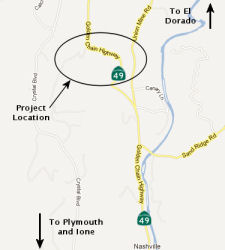
![[Route 49 near El Dorado]](maps/049-eldorado.jpg) In February 2009, the CTC
approved a project to realign, widen and add shoulders on Route 49 near El
Dorado (03-ED-49, PM 6.6/8.2). Depending on the availability of funding,
it is estimated that the Department will begin construction in Fiscal Year
2008-09.
In February 2009, the CTC
approved a project to realign, widen and add shoulders on Route 49 near El
Dorado (03-ED-49, PM 6.6/8.2). Depending on the availability of funding,
it is estimated that the Department will begin construction in Fiscal Year
2008-09.
 In April 2012, the CTC approved
for future consideration of funding a project that is located in the
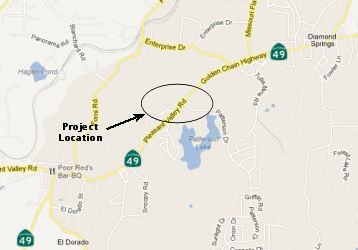
community of Diamond Springs in El Dorado County. The project will
signalize and improve the intersection of Pleasant Valley Road (Route 49)
and Patterson Drive (~ ED 10.704). Proposed improvements include widening
the approaches to the intersection; addition of turn pockets; installation
of traffic signals; installation of curbs, gutters, and sidewalks; grading
and paving; drainage improvements; and minor landscaping. The project is
estimated to cost $4.05 million and is programmed with State ($1,600,000)
funds and Local ($2,450,000) funds. Construction is estimated to begin in
fiscal year 2013/14.
In April 2012, the CTC approved
for future consideration of funding a project that is located in the
community of Diamond Springs in El Dorado County. The project will
signalize and improve the intersection of Pleasant Valley Road (Route 49)
and Patterson Drive (~ ED 10.704). Proposed improvements include widening
the approaches to the intersection; addition of turn pockets; installation
of traffic signals; installation of curbs, gutters, and sidewalks; grading
and paving; drainage improvements; and minor landscaping. The project is
estimated to cost $4.05 million and is programmed with State ($1,600,000)
funds and Local ($2,450,000) funds. Construction is estimated to begin in
fiscal year 2013/14.
In December 2007, the CTC considered relinquishment of right of way in the townsite of Diamond Springs, county of El Dorado, from approximately 213 feet west of the existing intersection of Route 49 and Pleasant Valley Road to 525 feet north of the existing intersection of Route 49 and Pleasant Valley Road and 256 feet east of the existing intersection of Route 49 and Pleasant Valley Road, consisting of superseded highway right of way (~ ED 11.871).
In May 2016, the CTC authorized $1,000,000 for a project in El Dorado County, on Route 49 from north of the intersection of Route 49 and Fowler Lane (~ ED 11.862) to Bradley Dr. (~ ED 12.364). Outcome/Output: Improve traffic safety and operations by realigning Route 49.
A new Route 49 alignment is planned between Placerville and Coloma (~ ED 14.832 to ED 23.112) directly paralleling Cold Springs Road.
South Fork American River Bridge (~ ED 023.99)
In May 2015, the CTC approved for future consideration of funding a project in El Dorado County that will replace the South Fork American Bridge on Route 49 near the towns of Coloma and Lotus. The project is programmed in the 2014 State Highway Operation and Protection Program. The estimated cost is $20,817,000 for capital and support. Construction is estimated to begin in Fiscal Year 2015-16. The scope, as described for the preferred alternative, is consistent with the project scope programmed by the Commission in the 2014 State Highway Operation and Protection Program.
In June 2016, the CTC approved $16,593,000 for a project in El Dorado County on Route 49 near Coloma, from 0.1 mile east of Marshall Road to 0.3 mile east of Lotus Road. Outcome/Output: Provide seismic standards and structural integrity by replacing South Fork American River Bridge No. 25-0021 on new alignment, constructing retaining walls, installing drainage systems, and relocating utilities
In March 2023, it was reported that the Placer County Board of
Supervisors unanimously approved a fund transfer agreement with Caltrans
that permits it to receive funding allocated for the removal of Route 49
Bridge debris in the North Fork of the American River (~ PLA 0.008). The
$8 million in funding was made available to Placer through Assembly Bill
178 within the California 2022-23 budget to “remove the steel and
concrete wreckage of the former State Route 49 Bridge that lies in the
American River.” The bridge broke into three pieces and was
washed away in December 1964, when the partially constructed Hell Hole Dam
failed during an atmospheric weather event. Just nine months later the
Auburn Dam Project was passed by Congress and signed into law by President
Johnson on September 2, 1965. The metal and concrete bridge debris
deposited in the river channel and along its banks was left where it was
because it was assumed the Auburn Reservoir would soon cover it under
hundreds of feet of water. However, the debris creates a hazard to those
who swim and boat this river segment in the heavily used Confluence area
of the Auburn State Recreation Area. The receipt of the funds is the first
step in getting the project underway and the execution of the transfer
agreement will assist in receiving the $8 million. From there, Placer
County will begin to evaluate the actual removal. They will do
environmental studies, make sure it’s feasible and safe and start
the process of working with stakeholders, regulatory agencies and to
eventually be able to remove the debris. Due to the funding being a
lump-sum bill, there is no option to increase the funds and the county
would have to go back to the legislative advocacy process for a new
allotment.
(Source: Gold County Media, 3/2/2023; Protect American River Canyons, 4/30/2023)
Although not directly on Route 49, there are plans to retrofit and
upgrade the Foresthill Bridge (~ PLA 0.044). The bridge was constructed in 1973 for $13 million as a proposed rerouting of Route 49 to avoid low-lying
areas that would be flooded when the Auburn Dam was completed. The dam,
however, was cancelled and the connection to Route 49 was never
constructed, leaving the bridge orphaned and maintained by Placer County.
In February 2010, it was reported that the bridge was up for an estimated
$71 million seismic retrofitting. Potential contractors were treated to an
up-close view of the bridge and briefed on the scope of work to be done,
including the complex job of painting the span without letting original
lead-based paint particles drop into the river below. Bids were to be
advertised in April 2010, and the contract to be awarded in May 2010.
Construction could start in August 2010 and last until 2012.
(Source: Auburn Journal, February 2010)
Cool to Auburn Corridor (~ ED 34.546 to PLA 3.128)
In April 2023, it was reported that a multi-year study
looking into a bevy of concerns regarding a stretch of Route 49 between
Cool and Auburn has provided a list of potential fixes. Narrow roadways,
tight turns, limited shoulders packed with parked cars, hikers and
river-goers crossing the road to and fro and oversized trucks driving
through tight turns all contribute to long drive times and raise the risk
of possible traffic incidents on Route 49. The El Dorado County
Transportation Commission, in partnership with California State Parks,
Caltrans, El Dorado County and the Placer County Transportation Planning
Agency, conducted a study after concerns were raised by local residents
and authorities in early 2020. Trip data, collected using the Replica Data
software platform, determined that travelers along the highway made trips
with an average distance of 58 miles, with longer trips during peak summer
months. The data suggested most travelers through the confluence area were
likely not local residents and average vehicle occupancy was 1.6 people
per vehicle. The Replica Data software platform collected information
using cell phone location data from within the study corridor. Key pain
points and potential solutions were identified through data collection,
public workshops and surveys between 2021 and 2023. Completed in February
2023, the EDCTC’s final report is a set of suggestions and
prioritized timelines; actual projects will require one or more of the
agencies in the area to schedule, budget and plan them, and would need to
go through a development process of possibly three to 10 years. Problems
and projects identified include:
(Source: Mountain Democrat, 4/3/2023)
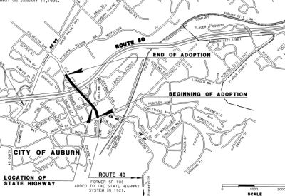
Lincoln Way/Borland Ave Curve Realignment and Roundabout (03-Pla-49, PM 1.8/2.4)
 In October 2016, the CTC amended into the SHOPP the
following: 3-Pla-49 2.2/2.4 | Route 49 In Auburn, from 0.3 mile south of
Lincoln Way/Borland Avenue to Lincoln Way/Borland Avenue. Realign curves.
Allocation: $764K (R/W), $1.697MM (C), Support (PA & ED $732K / PS
& E $1.003MM / RW Sup $306K / Con Sup $819K / Total $2.86MM). FY
19/20. The following project was also included in the final adopted 2018 SHOPP in March 2018.
In October 2016, the CTC amended into the SHOPP the
following: 3-Pla-49 2.2/2.4 | Route 49 In Auburn, from 0.3 mile south of
Lincoln Way/Borland Avenue to Lincoln Way/Borland Avenue. Realign curves.
Allocation: $764K (R/W), $1.697MM (C), Support (PA & ED $732K / PS
& E $1.003MM / RW Sup $306K / Con Sup $819K / Total $2.86MM). FY
19/20. The following project was also included in the final adopted 2018 SHOPP in March 2018.
(Image source: Caltrans 11/11/2022)
In January 2019, the CTC amended the SHOPP as follows:
03-Pla-49 2.2/2.4 PPNO 4785 Proj ID 0316000077. Route 49 In Auburn, from 0.3
0.2 mile south of Lincoln Way/Borland Avenue to Lincoln
Way/Borland Avenue. Realign curves roadway and construct
roundabout. Total est. cost: $5,324,000 $8,919,000.
(Source: January 2019 CTC Minutes, Agenda Item 2.1a(1) Amendment Item 6)
In June 2019, the CTC approved for future consideration
of funding a project located on Route 49 in the city of Auburn in Placer
County (03-Pla-49, PM 1.8/2.4). The project proposes to realign two
reverse curves at the Route 49/Borland Avenue/Lincoln Way intersection.
The project proposes to construct a roundabout facility and widen shoulder
widths to meet the Highway Design Manual standards. The proposed project
will address the need to reduce the number of collisions involving loss of
control in the reversing curves and trailer off-tracking on narrow
shoulders at tight radius curves. The project is currently programmed in
the 2018 SHOPP for an estimated total of $8.9 million, which includes
Construction (capital and support) and Right-of-Way (capital and support).
Construction is estimated to begin in 2020. The scope, as described for
the preferred alternative, is consistent with the project scope programmed
by the Commission in the 2018 SHOPP.
(Source: June 2019 CTC Minutes, Agenda Item
2.2c.(1))
In June 2019, the CTC approved the following SHOPP
support phase allocation: $1,500,000 03-Placer-49 2.2/2.4 PPNO 4785 ProjID
0316000077. Route 49 In Auburn, from 0.2 mile south of Lincoln Way/Borland
Avenue to Lincoln Way/Borland Avenue. Realign roadway and construct
roundabout. PS&E $1,150,000 R/W Support $350,000. (Concurrent
consideration of funding under Resolution E-19-50; June 2019.) (As part of
this allocation request, the Department is requesting to extend the
completion of the R/W Sup phase an additional 5 months beyond the 36 month
deadline.)
(Source June 2019 CTC Minutes, Agenda Item
2.5b.(2a) Item 13)
In October 2021, the CTC was informed of the following
SHOPP Safety Resolution G-03-10 Delegated Allocation: $6,270,000.
03-Pla-49 2.2/2.4. PPNO 03-4785; ProjID 0316000077; EA 1H240. Route 49 In
Auburn, from 0.2 mile south of Lincoln Way to Lincoln Way. Outcome/Output:
Realign roadway and construct a roundabout at the intersection with
Lincoln Way and Borland Avenue to improve traffic flow and safety.
This project will reduce the number and severity of collisions.(Additional
$69,550 contribution from City of Auburn for utility agreement.) (Future
consideration of funding approved under Resolution E-19-50; June 2019.)
(Sixteen month time extension for CONST and CON ENG approved under Waiver
20-31; June 2020.) Allocation: CON ENG $1,300,000; CONST $4,000,000.
(Source: October 2021 CTC Agenda, Agenda Item
2.5f.(3) #1)
In June 2022, the CTC approved a request for an
additional $2,276,000 in Construction Capital for the SHOPP Safety
Improvements project on Route 49, in Placer County, to award the
construction
contract (03-Pla-49 2.2/2.4, PPNO 03-4785; ProjID 0316000077; EA 1H240).
This project is located on Route 49 in the City of Auburn, at Lincoln Way,
in Placer County. The project will replace the signalized
intersection by realigning the roadway and constructing a
roundabout. This safety improvement project will reduce the number
of collisions experienced on this segment of Route 49. The project
will reduce the potential for rear-end collisions and other collisions
involving the loss of control in the reversing curves and will eliminate
problems due to trailer off-tracking on the narrow shoulders in the tight
radius curves. In June 2019, the project was programmed for $4,000,000 in
Construction Capital and $1,300,000 in Construction Support in the SHOPP
(Subprogram: Safety Improvements) for allocation in the Fiscal Year
2019-20. In June 2020, the project received a 16-month time
extension for project expenditure for the Plans, Specifications, and
Estimate phase. In August 2021, the project received a construction
allocation for $4,745,000 in Construction Capital and $1,525,000 in
Construction Support. In January 2022, the project received a
six-month time extension for awarding the project contract; bids were
opened in January 2022, and the amount required to award to the lowest
bidder exceeded the amount available from the approved project allocation
and G-12 allotment. In November 2021, the Department advertised the
contract, with the bid opening in January 2022. The contract
received four bids, however, the first and second-lowest ranked bidders
did not meet the “good faith effort” for the Disadvantaged
Business Enterprise (DBE) goals. The third lowest bidder is 42.0
percent above the Engineer’s Estimate (EE) and the fourth bidder is
52.6 percent above the EE. The lowest three bidders were contacted about
their bids. Each of them explained that their bids are higher than
anticipated due to the relatively smaller footprint of the project area,
risks related to utility relocation during construction, the restrictions
on the number of working days, and a slower production rate of work needed
due to short shifts and staged work, which is reflected in the bid items
related to sanitary sewer line relocation, traffic control, street
sweeping, structural concrete items. In addition, each of the contractors
stated that their bids reflected pressures related to the current supply
chain issues, labor shortages due to the pandemic, a higher DBE
recruitment goal, and current material price volatilities. The Department
had anticipated a higher price for the elements of the roundabout by
estimating the proposed scope of work based on historical unit prices and
escalating them to the midpoint of construction. In addition, the
Department included higher costs for the limitations of the footprint,
utility relocation risks, and possible risks associated with
constructability and traffic control. Although the project estimate
was updated six weeks prior to the approval of the allocation by the
Commission at the August 2021 meeting, when the supply chain issues and
labor shortages were still dynamic, it is possible that the overall
estimate was still undervalued as the current market trends are beyond
those expectations. Due to the recently implemented higher DBE
recruitment goal, no allowances were considered in the EE. The
biggest cost differences between the EE and lowest bid are related to the
unit prices for a number of bid items. In aggregate, these items amount to
an increase of $1,629,000 over the EE. The remaining increase is due
to minor unit price cost increases of other bid items. The Department has
determined that these additional requested supplemental funds are in
the best interest of the State to avoid delays in implementing this
important safety improvement project and avoid the extra cost to the
Department. The Department has exercised all feasible measures to
minimize costs in carrying out work related to this project and has
determined that this request is well-supported and is the only viable
alternative available.
(Source: May 2022 CTC Agenda, Agenda Item 2.5e.(3))
In October 2022, it was reported that construction had
started on a $9.9 million roadway project that will improve a quarter-mile
segment of Route 49 near Lincoln Way and Borland Avenue in south Auburn.
The project will realign two reversing curves to improve sight distance
and safety by reducing the sharpness of each curve. Additionally, the
existing traffic signal at the Lincoln Way/Borland Avenue intersection
will be replaced with a roundabout to improve safety and traffic flow.
This safety project is the second of three Auburn-area projects that will
improve the Route 49 corridor in Placer County. In spring 2022, Caltrans
completed a $47.4 million roadway improvement and complete streets project
between the I-80 separation and Dry Creek Road that widened shoulders,
added sidewalks and new traffic signals and rehabilitated the roadway. A
$26.7 million safety project is in development to add a median concrete
barrier on Route 49 between Lorenson Road and Lone Star Road in North
Auburn, with roundabouts providing operational improvements at the two
intersections.
(Source: District 3 on FB, 10/26/2022)
In April 2023, it was reported that preparation work
was resuming for a roundabout at the gateway to the American River Canyon
as utility contract work at the intersection of Lincoln Way and Borland
Avenue intersection begins. This map, provided to the city of Auburn by
the Caltrans contractor, outlines construction and traffic impacts
expected as part of the American Canyon Roundabout work, which has
restarted this week. The work is in preparation for Caltrans' $9.9 million
roadway project that aims to improve a quarter-mile segment of Route 49
near Lincoln Way and Borland Avenue. The project will align two reversing
curves to improve sight distance and safety by reducing the sharpness of
each curve. The work will include replacing the Lincoln Way/Borland Avenue
intersection with a traffic circle. After utility work is completed,
Caltrans' can restart its efforts to install a traffic circle at the busy
intersection, which is the gateway to recreational activities in the
Auburn State Recreation Area. The project was previously paused due to the
winter weather conditions.
(Source: Gold Country Media, 4/25/2023)
In May 2009, the CTC relinquished right of way in the city of Auburn on Route 49, under terms and conditions as stated in the relinquishment agreement dated April 14, 2009, determined to be in the best interest of the State. Authorized by Chapter 635, Statutes of 2008, which amended Section 349 of the Streets and Highways Code. (~ 3-Pla-49-PM 2.52/3.0)
 In February 2012, the CTC
adopted a routing for Route 49 in the city of Auburn (~ PLA 3.09 to PLA
3.276). The purpose of this route adoption is to address the lack of
continuity of Route 49 through the City of Auburn. On August 30, 2008, the
Governor signed Assembly Bill 1915 which amended Section 349 of the
Streets and Highways Code and provided the authority to relinquish a
portion of Route 49 within the City of Auburn. On May 14, 2009, at the
request of the City of Auburn and the California Department of
Transportation (Department), the California Transportation Commission
(Commission) relinquished a portion of Route 49 to the City of Auburn. The
relinquished portion extended from the I-80 interchange, along south Grass
Valley Highway, east on Lincoln Way and east on High Street to the
intersection with Elm Avenue. This stretch of highway is the main
thoroughfare through downtown Auburn and was part of a revitalization
project proposed by the City called Streetscape Project for Lincoln Way
and High Street. Phase 1 of this project was completed on June 28, 2010.
The City also wanted control over future projects proposed for
construction and to limit the amount of traffic and speed within the
downtown area. The City’s General Plan identifies this route as a
city street with multi-purpose mixed use. This route adoption as a
conventional highway will allow Route 49 to reconnect to I-80 via Elm
Avenue. The portion of Elm Avenue to be adopted is 0.3 mile long and is
classified as an urban minor arterial. It is a four-lane arterial with a
12-foot median, 5-foot shoulders with curb, gutter and sidewalks on both
sides of the road. Access to Elm Avenue between Tuttle Street and the
westbound I-80 on ramp is controlled and the median is used as left turn
lanes. East of Tuttle Street to the intersection of High Street / Route 49, the 12-foot median becomes a two-way left turn lane and there are
several driveways serving local businesses. This section does not have any
shoulders, but continues the curb, gutter and sidewalks from the previous
section. The portion of Elm Avenue from the I-80 on ramp to the
intersection with Route 49 is not included in this adoption, thus
maintaining a gap in Route 49 continuity, albeit a smaller gap. Continuity
can be obtained through the designation of I-80 between the Elm Avenue and
the Grass Valley Highway interchanges as I-80/Route 49. Elm Avenue
currently serves as the preferred truck route for truck traffic travelling
along Route 49 through the City of Auburn. Trucks travelling south from
Grass Valley predominately turn left on Elm Avenue to avoid downtown and
then another left on High Street to get back on Route 49. Trucks
travelling on I-80 predominately take the Elm Avenue off-ramp to access
southbound Route 49. To access northbound Route 49 from I-80, trucks may
either use Elm Avenue or Route 49 (Grass Valley Highway). For trucks
travelling north from El Dorado County, the preferred truck route diverges
from Route 49 once they enter the city due to a tight turning radius that
exists at the corner of existing Route 49 and Elm Avenue. Currently, at
this location, there are “Truck Route” signs placed by the
City to direct trucks to turn left on Lincoln Way and then right on Elm
Avenue. On December 12, 2011, the City of Auburn passed Resolution No.
11-123 approving the proposed Route 49 Route Adoption along Elm Avenue.
In February 2012, the CTC
adopted a routing for Route 49 in the city of Auburn (~ PLA 3.09 to PLA
3.276). The purpose of this route adoption is to address the lack of
continuity of Route 49 through the City of Auburn. On August 30, 2008, the
Governor signed Assembly Bill 1915 which amended Section 349 of the
Streets and Highways Code and provided the authority to relinquish a
portion of Route 49 within the City of Auburn. On May 14, 2009, at the
request of the City of Auburn and the California Department of
Transportation (Department), the California Transportation Commission
(Commission) relinquished a portion of Route 49 to the City of Auburn. The
relinquished portion extended from the I-80 interchange, along south Grass
Valley Highway, east on Lincoln Way and east on High Street to the
intersection with Elm Avenue. This stretch of highway is the main
thoroughfare through downtown Auburn and was part of a revitalization
project proposed by the City called Streetscape Project for Lincoln Way
and High Street. Phase 1 of this project was completed on June 28, 2010.
The City also wanted control over future projects proposed for
construction and to limit the amount of traffic and speed within the
downtown area. The City’s General Plan identifies this route as a
city street with multi-purpose mixed use. This route adoption as a
conventional highway will allow Route 49 to reconnect to I-80 via Elm
Avenue. The portion of Elm Avenue to be adopted is 0.3 mile long and is
classified as an urban minor arterial. It is a four-lane arterial with a
12-foot median, 5-foot shoulders with curb, gutter and sidewalks on both
sides of the road. Access to Elm Avenue between Tuttle Street and the
westbound I-80 on ramp is controlled and the median is used as left turn
lanes. East of Tuttle Street to the intersection of High Street / Route 49, the 12-foot median becomes a two-way left turn lane and there are
several driveways serving local businesses. This section does not have any
shoulders, but continues the curb, gutter and sidewalks from the previous
section. The portion of Elm Avenue from the I-80 on ramp to the
intersection with Route 49 is not included in this adoption, thus
maintaining a gap in Route 49 continuity, albeit a smaller gap. Continuity
can be obtained through the designation of I-80 between the Elm Avenue and
the Grass Valley Highway interchanges as I-80/Route 49. Elm Avenue
currently serves as the preferred truck route for truck traffic travelling
along Route 49 through the City of Auburn. Trucks travelling south from
Grass Valley predominately turn left on Elm Avenue to avoid downtown and
then another left on High Street to get back on Route 49. Trucks
travelling on I-80 predominately take the Elm Avenue off-ramp to access
southbound Route 49. To access northbound Route 49 from I-80, trucks may
either use Elm Avenue or Route 49 (Grass Valley Highway). For trucks
travelling north from El Dorado County, the preferred truck route diverges
from Route 49 once they enter the city due to a tight turning radius that
exists at the corner of existing Route 49 and Elm Avenue. Currently, at
this location, there are “Truck Route” signs placed by the
City to direct trucks to turn left on Lincoln Way and then right on Elm
Avenue. On December 12, 2011, the City of Auburn passed Resolution No.
11-123 approving the proposed Route 49 Route Adoption along Elm Avenue.
 Naming
 Much of this route is named the "Gold Country Highway" or the "Golden Chain
Highway". It was named for its location, because it links historic
towns and points of interest in California's gold country. The name
"Golden Chain Highway" seems to have been popularized by tourist
organizations on promotional materials for the highway (such as the
"Golden Chain Council of the Mother Lode"), and subsequently on websites promoting the highway.
Much of this route is named the "Gold Country Highway" or the "Golden Chain
Highway". It was named for its location, because it links historic
towns and points of interest in California's gold country. The name
"Golden Chain Highway" seems to have been popularized by tourist
organizations on promotional materials for the highway (such as the
"Golden Chain Council of the Mother Lode"), and subsequently on websites promoting the highway.
(Image source: Drive Highway 49, California's Golden Chain)
 The portion of this route between Sonora and Auburn (~
TUO 17.969 to PLA 1.256) is officially named the "Mother Lode Highway",
per Chapter 839 in 1921. It was named for its location. The "Mother Lode
Highway", named in 1921, connects towns and points of interest in
California's gold country.
The portion of this route between Sonora and Auburn (~
TUO 17.969 to PLA 1.256) is officially named the "Mother Lode Highway",
per Chapter 839 in 1921. It was named for its location. The "Mother Lode
Highway", named in 1921, connects towns and points of interest in
California's gold country.
(Image source: 1946 California Golden Chain Highway 49 Mother Lode Map)
 The portion of Route 49 one mile before and after its intersection
with Parrott's Ferry Road, in Tuolumne County (~ TUO 19.394 to TUO
21.394)is officially named the "Deputy Dave Grant Memorial Highway".
This segment was named in memory of Deputy David P. Grant, a 15 year
veteran of the Tuolumne County Sheriff's Department with more than 26
years of law enforcement experience. During the late morning of May 31,
2004, Deputy Grant suffered fatal injuries responding to a "plane down"
call near the town of Columbia. While responding to the call at a high
rate of speed, Deputy Grant's vehicle swerved to avoid colliding with two
other vehicles, left the roadway, and struck a tree. Deputy Grant was
critically injured and transported to the Sonora Regional Medical Center
where, surrounded by family and fellow deputies, he succumbed to his
injuries. This was the first loss for the Tuolumne County Sheriff's
Department in more than 37 years. At the age of 16, David P. Grant served
as an Explorer Cadet with the Sonora Police Department; and was sworn in
as a Sonora police officer in 1978. Desiring to broaden his experience in
a larger department, Deputy Grant accepted an appointment with the
Oceanside Police Department in 1981 and served the City of Oceanside with
distinction for eight years. He was sworn in as a Tuolumne County Deputy
Sheriff on October 9, 1989. Named by Assembly Concurrent Resolution (ACR)
132, Resolution Chapter 105, on 8/16/2006.
The portion of Route 49 one mile before and after its intersection
with Parrott's Ferry Road, in Tuolumne County (~ TUO 19.394 to TUO
21.394)is officially named the "Deputy Dave Grant Memorial Highway".
This segment was named in memory of Deputy David P. Grant, a 15 year
veteran of the Tuolumne County Sheriff's Department with more than 26
years of law enforcement experience. During the late morning of May 31,
2004, Deputy Grant suffered fatal injuries responding to a "plane down"
call near the town of Columbia. While responding to the call at a high
rate of speed, Deputy Grant's vehicle swerved to avoid colliding with two
other vehicles, left the roadway, and struck a tree. Deputy Grant was
critically injured and transported to the Sonora Regional Medical Center
where, surrounded by family and fellow deputies, he succumbed to his
injuries. This was the first loss for the Tuolumne County Sheriff's
Department in more than 37 years. At the age of 16, David P. Grant served
as an Explorer Cadet with the Sonora Police Department; and was sworn in
as a Sonora police officer in 1978. Desiring to broaden his experience in
a larger department, Deputy Grant accepted an appointment with the
Oceanside Police Department in 1981 and served the City of Oceanside with
distinction for eight years. He was sworn in as a Tuolumne County Deputy
Sheriff on October 9, 1989. Named by Assembly Concurrent Resolution (ACR)
132, Resolution Chapter 105, on 8/16/2006.
(Image Source: Officer Down Memorial Page)
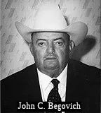 The segment from the southern city limit of the City of Jackson to the intersection of Route 88 (~ AMA 2.266 to AMA 4.013) is officially
named the "John C. Begovich Memorial Highway". John Begovich was an
elected public official from Amador County. He was born on January 17,
1916, in Jackson Gate, California. He graduated from Sutter Creek High
School and attended Sacramento Junior College and was a champion athlete
at both institutions. In 1942, he enlisted in the United States Army where
he rose to the rank of second lieutenant and earned 13 decorations,
including the silver star, the bronze star, and three purple hearts. In
1945, he returned to Amador County and was selected to be the county
Veterans Service Officer and County Civil Defense Director. In 1955, he
was appointed judge in the Amador County Judicial District while retaining
his position as Veterans Service Officer. In 1960, he was elected as
Senator from the 9th Senatorial District serving Amador and El Dorado
Counties and worked on numerous issues important to his constituents and
the state, including the bistate park system within the Tahoe Basin,
highway improvements, the creation of a second department of the Superior
Court for El Dorado County, and a $250,000,000 veterans bill. In 1966, he
was appointed by President Lyndon B. Johnson as one of four United States
Federal Marshals in the State of California, serving in that capacity
until 1970. In 1976, he was elected Supervisor of District 1, Amador
County, where he made care of the elderly residents of the county one of
his primary concerns. He was reelected as supervisor in 1980, 1984, 1988,
and 1992. He died on November 2, 1999. Named by Assembly Concurrent
Resolution 139, Chapter 120, August 30, 2000.
The segment from the southern city limit of the City of Jackson to the intersection of Route 88 (~ AMA 2.266 to AMA 4.013) is officially
named the "John C. Begovich Memorial Highway". John Begovich was an
elected public official from Amador County. He was born on January 17,
1916, in Jackson Gate, California. He graduated from Sutter Creek High
School and attended Sacramento Junior College and was a champion athlete
at both institutions. In 1942, he enlisted in the United States Army where
he rose to the rank of second lieutenant and earned 13 decorations,
including the silver star, the bronze star, and three purple hearts. In
1945, he returned to Amador County and was selected to be the county
Veterans Service Officer and County Civil Defense Director. In 1955, he
was appointed judge in the Amador County Judicial District while retaining
his position as Veterans Service Officer. In 1960, he was elected as
Senator from the 9th Senatorial District serving Amador and El Dorado
Counties and worked on numerous issues important to his constituents and
the state, including the bistate park system within the Tahoe Basin,
highway improvements, the creation of a second department of the Superior
Court for El Dorado County, and a $250,000,000 veterans bill. In 1966, he
was appointed by President Lyndon B. Johnson as one of four United States
Federal Marshals in the State of California, serving in that capacity
until 1970. In 1976, he was elected Supervisor of District 1, Amador
County, where he made care of the elderly residents of the county one of
his primary concerns. He was reelected as supervisor in 1980, 1984, 1988,
and 1992. He died on November 2, 1999. Named by Assembly Concurrent
Resolution 139, Chapter 120, August 30, 2000.
(Image Source: Claritage Press Blog, 1/7/2018)
 The portion of Route 49 from Valley View Way PM AMA R7.298 to approximately PM
AMA R10.560 before the Jay-D Ornsby-Adkins Bridge (bridge number 26-0043),
located at post mile R10.576, in the County of Amador is named the "America’s
Heroes–Veterans Memorial Highway". It was designated to
appreciate, admire, and honor the men and women who have served in the
Armed Forces of the United States of America to protect and defend our
country and the freedom, rights, and privileges enjoyed by all Americans.
Nearly two million veterans reside in the State of California, and the
County of Amador is home to many of these brave and honorable individuals.
This was an indication that the state assembly intends to make it a
priority to fully support our state’s veterans in ways that
commemorate their great sacrifice. Named by Assembly Concurrent Resolution
(ACR) 165, Chapter 125, Statutes of 2016, on August 16, 2016.
The portion of Route 49 from Valley View Way PM AMA R7.298 to approximately PM
AMA R10.560 before the Jay-D Ornsby-Adkins Bridge (bridge number 26-0043),
located at post mile R10.576, in the County of Amador is named the "America’s
Heroes–Veterans Memorial Highway". It was designated to
appreciate, admire, and honor the men and women who have served in the
Armed Forces of the United States of America to protect and defend our
country and the freedom, rights, and privileges enjoyed by all Americans.
Nearly two million veterans reside in the State of California, and the
County of Amador is home to many of these brave and honorable individuals.
This was an indication that the state assembly intends to make it a
priority to fully support our state’s veterans in ways that
commemorate their great sacrifice. Named by Assembly Concurrent Resolution
(ACR) 165, Chapter 125, Statutes of 2016, on August 16, 2016.
(Image source: Ledger Dispatch)
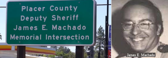 The intersection of Route 49 and Elm Avenue in the City of
Auburn (~ PLA 2.526) is named the "James E. Machado Memorial
Intersection". It was named in memory of James E. Machado, a deputy
sheriff with four years of service with the Placer County Sheriff’s
Department, who was shot and killed on July 13, 1978, with his own service
weapon, in a struggle with an escaped mental patient. The altercation
occurred on the shoulder of the northbound lanes of State Highway Route 49
at Elm Avenue in the City of Auburn. With the help of citizens who
witnessed the shooting, the suspect was quickly located by officers of the
California Highway Patrol and an officer of the Auburn Police Department.
The suspect confronted the responding officers with Deputy Machado’s
service weapon, and was subsequently killed when the officers fired
several rounds at the suspect. Law enforcement officers from throughout
the state attended Deputy Machado’s funeral, and he was posthumously
awarded the Placer County Sheriff’s Purple Heart. Named by Senate
Concurrent Resolution 114, Resolution Chapter 102, on August 7, 2014.
The intersection of Route 49 and Elm Avenue in the City of
Auburn (~ PLA 2.526) is named the "James E. Machado Memorial
Intersection". It was named in memory of James E. Machado, a deputy
sheriff with four years of service with the Placer County Sheriff’s
Department, who was shot and killed on July 13, 1978, with his own service
weapon, in a struggle with an escaped mental patient. The altercation
occurred on the shoulder of the northbound lanes of State Highway Route 49
at Elm Avenue in the City of Auburn. With the help of citizens who
witnessed the shooting, the suspect was quickly located by officers of the
California Highway Patrol and an officer of the Auburn Police Department.
The suspect confronted the responding officers with Deputy Machado’s
service weapon, and was subsequently killed when the officers fired
several rounds at the suspect. Law enforcement officers from throughout
the state attended Deputy Machado’s funeral, and he was posthumously
awarded the Placer County Sheriff’s Purple Heart. Named by Senate
Concurrent Resolution 114, Resolution Chapter 102, on August 7, 2014.
(Image Source: YouTube video of Dedication; PlacerCounty
Sheriff's Dept. via SacBee)
Named Structures![[Stevenot Plaque]](images/049-stevenot-plaque.jpg) Bridge 32-0040 over the Stanislaus River in Tuolumne and Calaveras counties (~ R027.28) is named the "Archie Stevenot Bridge".
It was constructed in 1976, and was named by Senate Resolution 338, Page
4758, in 1988. Archie Stevenot (d. 1968), miner, cowboy, rancher,
postmaster, and ox team swamper, helped found the California State Chamber
of Commerce and was officially named "Mr. Mother Lode" by the California
legislature. He was also the founder of the "Mother Lode Association" in
1919, which was the first highway association and promoted the assignment
of the number "49" to Route 49.
Bridge 32-0040 over the Stanislaus River in Tuolumne and Calaveras counties (~ R027.28) is named the "Archie Stevenot Bridge".
It was constructed in 1976, and was named by Senate Resolution 338, Page
4758, in 1988. Archie Stevenot (d. 1968), miner, cowboy, rancher,
postmaster, and ox team swamper, helped found the California State Chamber
of Commerce and was officially named "Mr. Mother Lode" by the California
legislature. He was also the founder of the "Mother Lode Association" in
1919, which was the first highway association and promoted the assignment
of the number "49" to Route 49.
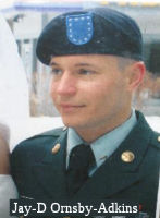 The Route 49 Amador Creek Bridge, Bridge No. 26-0043 (AMA R010.56),
is named the "Jay-D Ornsby-Adkins Bridge." This bridge was named in
memory of Jay-D Ornsby-Adkins, born on December 9, 1985, in Middle Swan,
Western Australia. He attended Ione Elementary School in Ione, Amador
County, and graduated from Independence High School in Sutter Creek,
Amador County, in 2005. He pursued a career in the United States Army and
graduated from basic training on December 8, 2006, at Ft. Knox, Kentucky.
He was assigned to the Delta Company 1st Battalion, 15th Infantry
Regiment, at Ft. Benning, Georgia, where he continued to train, advance
his skills, and prepare for combat, and earned the expert badge for
grenade, rifle sharpshooter, and pistol marksman. On March 9, 2007, Jay-D
Ornsby-Adkins was deployed to Iraq as a member of the Delta Company 1st
Battalion, 15th Infantry Regiment; and on April 28, 2007, while on patrol,
Private First Class Ornsby-Adkins and three other members of his unit died
in combat. Named by Senate Concurrent Resolution (SCR) 84, Resolution
Chapter 86, on 7/10/2008.
The Route 49 Amador Creek Bridge, Bridge No. 26-0043 (AMA R010.56),
is named the "Jay-D Ornsby-Adkins Bridge." This bridge was named in
memory of Jay-D Ornsby-Adkins, born on December 9, 1985, in Middle Swan,
Western Australia. He attended Ione Elementary School in Ione, Amador
County, and graduated from Independence High School in Sutter Creek,
Amador County, in 2005. He pursued a career in the United States Army and
graduated from basic training on December 8, 2006, at Ft. Knox, Kentucky.
He was assigned to the Delta Company 1st Battalion, 15th Infantry
Regiment, at Ft. Benning, Georgia, where he continued to train, advance
his skills, and prepare for combat, and earned the expert badge for
grenade, rifle sharpshooter, and pistol marksman. On March 9, 2007, Jay-D
Ornsby-Adkins was deployed to Iraq as a member of the Delta Company 1st
Battalion, 15th Infantry Regiment; and on April 28, 2007, while on patrol,
Private First Class Ornsby-Adkins and three other members of his unit died
in combat. Named by Senate Concurrent Resolution (SCR) 84, Resolution
Chapter 86, on 7/10/2008.
Bridge 26-0017, PM AMA 012.14, commonly known as the "Rancheria Creek Bridge", was officially named the "Amador County Veterans Memorial Bridge". Named by Senate Concurrant Resolution 43, Chapter 106, in 1997.
This route also had the following Safety Roadside Rest Areas:
Scenic Route[SHC 263.4] Entire portion.
Freeway[SHC 253.4] From Route 108 south of Jamestown to Route 108 near Sonora; and from Route 88 near Jackson to Route 50 near Placerville. These segments were added to the Freeway and Expressway system in 1959.
 Alternate Routes
The following cities within this segment sign the route to make distinction between "Historic" Route 49 and "Bypass" Route 49:
The following communities do not have historic or bypass signage, but do have streets named "Old Highway 49" (or something similar):
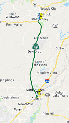 (4) From Route 80 near Auburn to Route 20 in Grass Valley.
Post 1964 Signage History▸As defined in 1963, this was a single segment running from "Route 120 to Route 20 via Sonora, Angels Camp, San Andreas, Jackson, El Dorado, Diamond Springs, Placerville, and Auburn." Before the year was out, this was split into two segments by Chapter 1698: "(b) Route 120 to Route 80 in Auburn via the vicinity of Sonora; via Angels Camp, San Andreas, and Jackson; via the vicinity of El Dorado, Diamond Springs, and Placerville. (c) Route 80 near Auburn to Route 20."
▸In 1984, Chapter 409 changed the wording of the terminus to "Route 80 near Auburn to Route 20 in Grass Valley."
The very high Foresthill Bridge for Foresthill Road over the American River was built in the 1970s as part of construction for the abandoned Auburn Dam project; the bridge was built in the case that Old Foresthill Road and Route 49 would be flooded out by the then-forthcoming Auburn Reservoir (which never came to fruition). According to Travis Mason-Bushman, after the construction of the dam, Route 49 would've been placed on the bridge, but as construction halted in 1976, this never materalized (although some officials in Auburn still hope for the dam to be built). Currently, this bridge (located about a half mile from Route 49 on Foresthill Road) is the third-highest in the United States.
A discussion of the Highways to Boulevards program during the March 2022
CTC meeting identified the following segment(s) as potential Highways to
Boulevards conversion projects: Route 49 North of Bell Road (~ PLA 6.391);
Route 49 near Palm Avenue (~ PLA 3.787)
(Source: March 2022 CTC Agenda, Agenda Item 4.3)
Pre 1964 Signage HistoryIn 1934, Route 49 was signed along the route from Jct Route 140 at Mariposa to Jct. Route 24 (now Route 70) near Reno Jct, via Sonora, Jackson, and Nevada City. It was LRN 17, and was defined in 1909.
 In 1962, the CHC adopted a freeway routing for 4.5 mi
between Rock Creek and 0.2 mi S of the Nevada County Line at the Bear
River. In 1975, the CHC published a notice of intent to abandon this
freeway adoption. It was not scheduled for construction in the foreseeable
future and no right of way had been acquired.
In 1962, the CHC adopted a freeway routing for 4.5 mi
between Rock Creek and 0.2 mi S of the Nevada County Line at the Bear
River. In 1975, the CHC published a notice of intent to abandon this
freeway adoption. It was not scheduled for construction in the foreseeable
future and no right of way had been acquired.
(Source: Sacramento Bee, 7/10/1975, via Joel Windmiller, 2/25/2023)
 In 1954, it was reported that a freeway routing for Route 40 between a point near the Placer County line (~ PLA 11.308) to 1.5 mi S
of Rattlesnake Creek (~ NEV 7.214) had been adopted. The route follows in
general the existing highway, with minor changes to straighten curves and
eliminate humps. However, given the lack of interchanges as of 2023, it
appears the freeway was never constructed.
In 1954, it was reported that a freeway routing for Route 40 between a point near the Placer County line (~ PLA 11.308) to 1.5 mi S
of Rattlesnake Creek (~ NEV 7.214) had been adopted. The route follows in
general the existing highway, with minor changes to straighten curves and
eliminate humps. However, given the lack of interchanges as of 2023, it
appears the freeway was never constructed.
(Source: Auburn Journal, 4/29/1954, via Joel Windmiller,
2/1/2023)
StatusIn December 2014, the CTC authorized relinquishment of right of way in the city of Auburn along Route 49 at Fulweiler Avenue (~ PLA 3.469), Palm Avenue (~ PLA 3.782), and Persimmon Drive (~ PLA 3.927), consisting of collateral facilities. The City, by cooperative agreement dated April 26, 2004 and by letter signed June 26, 2013, agreed to waive the 90-day notice requirement and accept title upon relinquishment by the State. The County, by cooperative agreement dated June 8, 2004 and by letter signed September 19, 2013, agreed to waive the 90-day notice requirement and accept title upon relinquishment by the State.
Highway 49 Safety Study (~ PLA 3.26 to NEV R13.705)
In November 2020, it was reported that Caltrans was
releasing the State Route (SR) 49 Safety Assessment Report (http://www.hwy49safety.com/) highlighting safety findings and proposed improvements to the corridor
between I-80 in Auburn and McKnight Way in Grass Valley. In February 2020,
a team including Caltrans and its transportation partners embarked on a
safety assessment of the Route 49 corridor to identify safety-related
improvements that could be installed in the very near term, identify
enhancements that could be added to planned construction projects, and
plan longer-term projects to improve corridor safety. For analysis
purposes, the team divided the corridor into four segments of similar
characteristics based on features that include population density, traffic
volumes and the rural or urban nature of the area:
(Source: Yubanet.Com, 11/10/2020; State Route 49: I-80 to McKnight Way Draft Safety Assessment Report)
The existing safety features and collision history of
each segment were assessed and used to outline recommendations for
improvements to the corridor. There were specific key issues identified
for the entire corridor, as well as for each segment. Examples include:
(Source: State Route 49: I-80 to McKnight Way Draft Safety Assessment Report)
The report also identifies near and long term safety
improvement recommendations in both non-engineering and engineering
domains. The former stresses the education and enforcement options
available. The engineering options emphasize signage, markings, and simple
roadway features in the near term. Long term engineering measures are more
substantial: raised medians, turn pockets, wider roadways, changeable
message signs, wildlife crossings, vehicle pullout areas, intersection
improvements, and much more.
(Source: State Route 49: I-80 to McKnight Way Draft Safety Assessment Report)
Highway 49 Rehabilitation Project (~ PLA 3.26 to PLA 7.426)
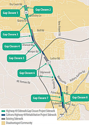 In February 2019, it was reported that the Highway 49 Gap Closure Project
will close the gaps between sidewalks in the approximately 4.4-mile Route 49 corridor between I-80 and Dry Creek Road (~ PLA 3.26 to PLA 7.426),
creating a continuous sidewalk on at least one side of the highway. This
project is just one of several on-going efforts to improve Route 49 by
constructing sidewalks, bike lanes, and operational improvements. In
spring of 2017, Caltrans was scheduled to repair sections of Route 49
within the greater Auburn area. During the planning process, Caltrans
acquired additional funding to add bike lanes in both directions and
sidewalks in certain segments, creating what’s known today as the
“Highway 49 Rehabilitation Project.” While
the additional money expanded the scope of improvements to Route 49,
sidewalk gaps would still remain in the corridor, even after the Route 49
Rehabilitation . In 2018, Placer County constructed approximately one-half
mile of sidewalks on Route 49 in front of the Bel Air Shopping Center
between New Airport Road and just north of Willow Creek Drive. At the
request of the City of Auburn and Placer County, PCTPA agreed to lead a
multi-agency effort to determine where and how to fill in the remaining
sidewalk gaps. The Route 49 Sidewalk Gap Closure project creates a
“shelf ready” project by completing the required environmental
and design work. This project was originally incorporated into the Placer
County Measure M transportation sales tax measure that failed back in
November 2016. The Measure M sales tax measure would have constructed
sidewalks, incorporated traffic signal synchronization, landscaping, and
operational improvements throughout the corridor. Without the passage of
Measure M, PCTPA looked to other funding opportunities such as the
extremely competitive Statewide Active Transportation Program (ATP) grant
to deliver a scaled down version of the original project. At the
California Transportation Commission’s (CTC) January 26, 2019
meeting, the CTC approved a $14.4 million dollar grant to construct
approximately 2.8 miles of sidewalk. The grant also included funding to
develop and implement a Safe Routes to School program at six area school
in partnership with the Placer County Department of Public Health. The
schools in the corridor include Rock Creek Elementary, Auburn Elementary,
E.V. Cain Middle School, Maidu High Independent Study, Confluence High
School and Placer High School.
In February 2019, it was reported that the Highway 49 Gap Closure Project
will close the gaps between sidewalks in the approximately 4.4-mile Route 49 corridor between I-80 and Dry Creek Road (~ PLA 3.26 to PLA 7.426),
creating a continuous sidewalk on at least one side of the highway. This
project is just one of several on-going efforts to improve Route 49 by
constructing sidewalks, bike lanes, and operational improvements. In
spring of 2017, Caltrans was scheduled to repair sections of Route 49
within the greater Auburn area. During the planning process, Caltrans
acquired additional funding to add bike lanes in both directions and
sidewalks in certain segments, creating what’s known today as the
“Highway 49 Rehabilitation Project.” While
the additional money expanded the scope of improvements to Route 49,
sidewalk gaps would still remain in the corridor, even after the Route 49
Rehabilitation . In 2018, Placer County constructed approximately one-half
mile of sidewalks on Route 49 in front of the Bel Air Shopping Center
between New Airport Road and just north of Willow Creek Drive. At the
request of the City of Auburn and Placer County, PCTPA agreed to lead a
multi-agency effort to determine where and how to fill in the remaining
sidewalk gaps. The Route 49 Sidewalk Gap Closure project creates a
“shelf ready” project by completing the required environmental
and design work. This project was originally incorporated into the Placer
County Measure M transportation sales tax measure that failed back in
November 2016. The Measure M sales tax measure would have constructed
sidewalks, incorporated traffic signal synchronization, landscaping, and
operational improvements throughout the corridor. Without the passage of
Measure M, PCTPA looked to other funding opportunities such as the
extremely competitive Statewide Active Transportation Program (ATP) grant
to deliver a scaled down version of the original project. At the
California Transportation Commission’s (CTC) January 26, 2019
meeting, the CTC approved a $14.4 million dollar grant to construct
approximately 2.8 miles of sidewalk. The grant also included funding to
develop and implement a Safe Routes to School program at six area school
in partnership with the Placer County Department of Public Health. The
schools in the corridor include Rock Creek Elementary, Auburn Elementary,
E.V. Cain Middle School, Maidu High Independent Study, Confluence High
School and Placer High School.
(Source: Hwy 49 Gap Closure Project Page)
In June 2019, it was reported that Caltrans will begin
construction in mid-June 2019 on the $40.5 million project in Auburn, with
funding provided by Senate Bill 1 (SB 1), the Road Repair and
Accountability Act of 2017. The project, which stretches 4.4 miles from
the I-80/Route 49 interchange to Dry Creek Road, will rehabilitate
existing pavement and drainage, improve operational features and upgrade
pedestrian and bicycle facilities. Class II bicycle lanes will be
installed northbound and southbound on Route 49 between Elm Avenue and Dry
Creek Road, with bike timing loops at each signal to assist bicyclists
traveling the four-mile stretch. The project has been awarded to Flatiron
West, Inc. In addition to improving the highway’s durability and
ride quality with 21 lane miles of a Hot-Mix Asphalt (HMA) overlay,
construction crews will install new traffic signals at Locksley Lane and
Shale Ridge Road. Highway shoulders and pedestrian facilities will also be
upgraded to comply with the Americans with Disabilities Act (ADA).
Construction is anticipated to be completed in summer 2020.
(Source: YubaNet.Com, 6/4/2019)
In December 2014, the CTC authorized relinquishment of right of way in the county of Placer along Route 49 from Marguerite Mine Road (~ PLA 4.554) to Bell Road (~ PLA 6.382), consisting of collateral facilities.
Placer 49 Safety Barrier Project / Roundabout Plan (03-Placer-49 PM R8.7/R10.6)
") In August 2017, it was reported that Caltrans had
presented a concept — emphasis on the concept part
— called the Highway 49 roundabout plan. That concept envisions a
center barrier from North Auburn (~ PLA 4.676) to Grass Valley (~ NEV
R14.318). It would feature roundabouts, placed every 1¼ to 1½
miles, enabling drivers to leave the highway or change direction on the
road. Traffic lights wouldn't exist. The roundabouts would take their
place. Left-hand turns from a driveway onto the highway could no longer
occur. Instead motorists would turn right and follow the road to the
nearest roundabout, where they could turn around. The concept permits
creation of a center median that many people want. There is no price tag
on this idea, nor has there been any engineering work.
In August 2017, it was reported that Caltrans had
presented a concept — emphasis on the concept part
— called the Highway 49 roundabout plan. That concept envisions a
center barrier from North Auburn (~ PLA 4.676) to Grass Valley (~ NEV
R14.318). It would feature roundabouts, placed every 1¼ to 1½
miles, enabling drivers to leave the highway or change direction on the
road. Traffic lights wouldn't exist. The roundabouts would take their
place. Left-hand turns from a driveway onto the highway could no longer
occur. Instead motorists would turn right and follow the road to the
nearest roundabout, where they could turn around. The concept permits
creation of a center median that many people want. There is no price tag
on this idea, nor has there been any engineering work.
(Source: The Union, 8/15/2017; Image source: Yubanet.Com 5/19/2021 and Caltrans Postmile Tool)
In October 2017, the roundabout notion reappeared, when
Caltrans presented initial design graphics and a more in-depth look at the
proposed plan. Roundabouts on Route 49 would allow drivers prevented from
turning left by the proposed concrete median barrier to reverse course "in
an efficient and safe manner as well as address a frequently voiced
community concern — speeding motorists," the department said in a
news release. Ten safety improvement projects on Route 49 are planned by
Caltrans over the next six years, Whitmore said, in addition to increased
funding for California Highway Patrol enforcement of traffic laws. Those
projects include installing flashing beacons at Alta Sierra Drive (~ NEV
9.213), upgrading intersection lighting at Brewer Road, installing radar
speed feedback signs at various locations, and widening shoulders in some
areas, among others.
(Source: The Union, 10/5/2017)
In August 2019, the CTC amended the following project
into the 2018 SHOPP: 03-Pla-49 R8.7/R10.6. PPNO 4787. Proj ID 0319000004.
EA 4H600. Route 49 Near Auburn, from 0.3 mile south of Lorenson
Road/Florence Lane to 0.3 mile north of Lone Star Road. Construct concrete
median barrier and two roundabouts. Total Cost: $26,340K. Begin Const
9/5/2022.
(Source: August 2019 CTC Agenda/Minutes, Agenda
Item 2.1a.(1) Item 47)
In August 2019, the CTC approved the following
allocation: 03-Pla-49 R8.7/R10.6. PPNO 4787 Proj ID 0319000004 EA 4H600.
Route 49 Near Auburn, from 0.3 mile south of Lorenson Road/Florence Lane
to 0.3 mile north of Lone Star Road. Construct concrete median barrier and
two roundabouts. (Concurrent amendment under SHOPP Amendment 18H-011.)
PA&ED $1,500,000.
(Source: August 2019 CTC Agenda, Agenda Item
2.5b.(2a) #11)
The 2020 SHOPP, approved in May 2020, included the
following Collision Reduction item of interest (carried over from the 2018
SHOPP): 03-Placer-49 PM R8.7/R10.6 PPNO 4787 Proj ID 0319000004 EA 4H600.
Route 49 near Auburn, from 0.3 mile south of Lorenson Road/Florence Lane
to 0.3 mile north of Lone Star Road. Construct concrete median barrier and
two roundabouts. Programmed in FY21-22, with construction scheduled to
start in September 2022. Total project cost is $26,340K, with $20,500K
being capital (const and right of way) and $5,840K being support
(engineering, environmental, etc.).
(Source: 2020 Approved SHOPP a/o May 2020)
In May 2021, it was reported that Caltrans was
conducting virtual public meetings seeking community comments about the
proposed safety improvement project on Route 49 in Placer County. The
purpose of the safety project is to reduce cross centerline collisions by
installing a concrete median barrier on Route 49 between Lorenson
Road/Florence Lane and Lone Star Road in Placer County. To account for
out-of-direction travel by the construction of a median barrier, Caltrans
is proposing to install roundabouts or traffic signals at the Lorenson
Road/Florence Lane and Lone Star Road intersections to accommodate U-turn
movements.
(Source: FB Event Announcement, May 2021; Caltrans News Release, 5/19/2021)
In June 2021, the CTC approved the following SHOPP
amendment: 03-Pla-49 R8.7/R10.6. PPNO 4787 ProjID 0319000004 EA 03-4H600.
Route 49 Near Auburn, from 0.3 mile south of Lorenson Road/Florence Lane
to 0.3 mile north of Lone Star Road. Construct concrete median
barrier and two roundabouts. Note: Additional construction capital is
needed to account for added drainage systems along the median barrier, an
increase to the roundabout radius to accommodate truck turning movements,
and environmental mitigation. Additional R/W capital is needed for an
increase to utility relocations and for environmental mitigation
acquisitions. R/W Cap $2,000K $2,820K; Const Cap $18,500K
$27,010K; Total $26,340K $35,670K.
(Source: June 2021 CTC Agenda, Agenda Item
2.1a.(2d) #12)
In October 2021, the CTC approved the following project
for future consideration of funding: 03-Pla-49, PM R8.7/R10.6. Placer
49 Safety Barrier Project. Construct a concrete median barrier and
other safety features on Route 49 in Placer County. (MND) (PPNO 4787)
(SHOPP) (Related Item under Ref. 2.5b.(2)). This project is located on
Route 49 near Auburn, between Lorenson Road/Florence Lane and Lone Star
Road, in Placer County. The Department proposes to construct a concrete
median barrier on Route 49 to reduce the number and severity of cross
median collisions within this segment. In addition, safe turning
movements, including U-turn movements for out-of-direction travel as a
result from the construction of the concrete median barrier, will be
installed. This project is currently programmed in the 2020 SHOPP for a
total of $35,670,000, which includes Construction (capital and support)
and Right of Way (support). Construction is estimated to begin in 2022.
The scope, as described for the preferred alternative, is consistent with
the project scope as programmed by the Commission in the 2020 SHOPP. A
copy of the MND has been provided to Commission staff. The project
will result in less than significant impacts to the environment after
mitigation.
(Source: October 2021 CTC Agenda, Agenda Item
2.2c.(1))
In October 2021, the CTC approved the following
allocation for preconstruction project phases: $1.840,000. 03-Pla-49
R8.7/R10.6. PPNO 03-4787; ProjID 0319000004; EA 4H600. Route 49 Near
Auburn, from 0.3 mile south of Lorenson Road/Florence Lane to 0.3 mile
north of Lone Star Road. Construct concrete median barrier and two
roundabouts. (Concurrent consideration of funding under Resolution
E-21-89; October 2021.) (Four month time extension for PS&E and R/W
Sup approved under Waiver 21-59; June 2021) Allocation: PS&E
$940,000; R/W Sup $900,000.
(Source: October 2021 CTC Agenda, Agenda Item
2.5b.(2a) #5)
In August 2023, the CTC approved the following project
for future consideration of funding: 03-Pla-49, PM R8.7/R10.6. Placer
49 Safety Barrier Project. Construct a concrete median barrier and
two roundabouts in Placer County. (MND Addendum) (PPNO 4787) (SHOPP). The
project is located on Route 49, from postmile (PM) R8.7 to PM R10.6, in
Placer County. The Department proposes to construct a concrete median
barrier and two roundabouts. The project is currently programmed in the
2020 State Highway Operation and Protection Program (SHOPP) for a total of
$35,670,000, which includes Right of Way (Support and Capital) and
Construction (Support and Capital). Construction began in 2022-23. The
scope, as described for the preferred alternative, is consistent with the
project scope as programmed by the Commission in the 2020 SHOPP. A copy of
the MND has been provided to Commission staff. The Commission approved the
project for future consideration of funding on October 13, 2021, under
Resolution E-21-89. Since the approval of the MND there have been changes
to the project and an Addendum pursuant to the California Environmental
Quality Act (CEQA) was prepared. These changes include drainage
improvements including roadside ditch realignment and grading at PM R9.30,
PM R9.90, and PM R9.94. The upgraded drainage elements at the three new
locations would have impacts to ephemeral (0.010 acre) and intermittent
(0.002 acre) drainages and scrub shrub wetlands (0.030 acre). The drainage
element upgrades would include side ditch realigning and grading for
positive drainage and graded into a trapezoidal ditch to accommodate
drainage flows. The project activities would consist of vegetation removal
and roadway excavation. The decision was made to prepare a CEQA Addendum
because the original MND had discussed and analyzed impacts to the same
biogeographical areas. The project changes were deemed less than
significant. The impact at these three locations to upgrade drainage
elements and roadside ditch realignment was not considered a significant
increase in impacts. The project changes do not meet the criteria outlined
in CEQA Guidelines Section 15162 to prepare a Subsequent MND. The
Department subsequently completed an Addendum to the MND pursuant to CEQA.
The Department has approved this project for construction. This approval
and the Addendum will satisfy the environmental requirements for this
stage of the planning process.
(Source: August 2023 CTC Agenda, Agenda Item 2.2c.(2) Item 1)
In August 2023, the CTC approved a request for an
additional $150,000 in Plans, Specifications and Estimate (PS&E) and
$50,000 in Right of Way (RW) Capital Outlay Support (COS), for the SHOPP
Safety Improvements project on Route 49, in Placer County, to complete the
PS&E and RW phases. This project (03-PLA-49 R8.7/R10.6, PPNO 03-4787;
ProjID 0319000004; EA 4H600) is located on Route 49, near the City of
Auburn (City), south of Lorenson Road/Florence Lane to north of Lone Star
Road, in Placer County. The project will construct a concrete median
barrier and two roundabouts. In August 2019, this project’s PS&E
and RW phases were programmed for $940,000 and $900,000 in the SHOPP for
completion in Fiscal Year 2021-22. In June 2020, the project
received a 4-month allocation time extension for PS&E and RW Support.
In October 2021, the project received a PS&E allocation for $940,000
and RW allocation for $900,000. In March 2022, the project received G-12
funds in the amount of $294,000 for PS&E. In October 2022, the project
received G-12 funds in the amount of $290,000 for RW Support. In
June 2022, the project received a 20-month allocation time extension for
the construction phase. The PS&E phase is currently 90 percent
complete and the RW phase is 75 percent complete. The remaining
budget is $46,000 for the PS&E phase and $130,000 for the RW phase,
which is insufficient to complete the phases. The project completed
Ready to List in June 2023, and is anticipated to complete the remaining
PS&E activities by January 2024. The project realized cost increases
to the PS&E and RW phases due to the complex design and construction
staging, challenging right of way acquisition efforts involving multiple
parcels, and additional coordination with the permitting agencies. The
project location is in a rural setting north of the City with rolling hill
terrain. This segment of SR 49 is a 5-lane highway with a 65 miles
per hour posted speed. The proposed 1.3-mile median barrier prevents
cross-median collisions with roundabouts at both ends of the median
barrier to limit out-of-direction travel by providing legal U-turn
movements and as traffic calming measures. The roundabouts are
designed for two through lanes of traffic and a turning radius sufficient
for California legal trucks. Constructing the roundabouts with a design
speed of 25 miles per hour on a 65-mile per hour 5-lane highway required
complex construction staging and traffic handling. The large
footprint required to build the roundabouts resulted in impacts to
adjacent property owners, utilities, and environmentally sensitive areas.
Additional design work was done to reduce the roadway footprint and the
amount of area required for right of way acquisition, reduce utility
conflicts, and lessen impacts on environmentally sensitive areas. Right of
way was impacted by negotiations with a property owner for permanent
acquisition and utility easements on four of their parcels. The
condemnation process was required to obtain possession of the property
owner’s multiple parcels.
(Source: August 2023 CTC Agenda, Agenda Item 2.5e.(4))
In October 2023, the CTC was informed of the following
SHOPP Safety Sub-Allocation: $31,880,000. 03-Pla-49 R8.7/R10.6. PPNO
03-4787: ProjID 0319000004; EA 4H600. Route 49 Near Auburn, from 0.3 mile
south of Lorenson Road/Florence Lane to 0.3 mile north of Lone Star
Road. Outcome/Output: Construct concrete median barrier and
two roundabouts to improve safety. This project will reduce the
number and severity of collisions. CEQA - MND, 8/6/2021; Re-validation
6/30/2023. NEPA - FONSI, 8/6/2021; Re-validation 6/30/2023. Future
consideration of funding approved under Resolution E-21-89; October 2021.
Twenty month allocation time extension for CONST and CON ENG approved
under Waiver 22-73; June 2022. Allocation Date: 07/28/2023.
(Source: October 2023 CTC Agenda, Agenda Item 2.5f.(3) #1)
In May 2019, the CTC authorized relinquishment of right of way in the
county of Nevada (County) along Route 49 at Woodridge Drive (03-Nev-49-PM
1.9, 1 segment), consisting of a collateral facility. The County by letter
signed March 28, 2019, agreed to waive the 90-day notice requirement and
accept title upon relinquishment by the State.
(Source: May 2019 CTC Minutes, Agenda Item 2.3c)
In January 2021, it was reported that Caltrans celebrated the completion
of construction of two acceleration lanes – a 500-foot-long
southbound acceleration lane with a 660-foot merge taper and a
900-foot-long northbound acceleration lane with a 660-foot merge taper
– at the Wolf Road/Combie Road intersection (NEV 2.183). In
addition, highway drainage was upgraded and Americans with Disabilities
Act (ADA)-compliant curb ramps were constructed at the intersection.
Additional project safety features will include overhead lighting at the
beginning of the merge tapers in each direction, set to be installed later
in January 2021.
(Source: Caltrans News Release, 1/12/2021)
Route 49 Grass Valley Wildfire Evacuation Route (03-Nevada-49 2.1 /9.8)
In January 2024, Caltrans released the draft 2024
SHOPP, which contained the following project: 03-Nevada-49 2.1 /9.8. PPNO
03-4143; ProjID 0323000087; EA 4J110. Route 49 Near Grass Valley, from
Wolf
Road/Combie Road to Ponderosa Pines Road. Widen shoulders, construct
two-way left-turn lane, rehabilitate pavement and drainage systems, and
upgrade lighting, signs, guardrail, and Traffic Management System (TMS)
elements. (Additional contribution of $25,000,000 from Nevada County
Transportation Commission in Local Transportation Climate Adaptation
Program (LTCAP) funds.) Proposed ($ × 1000): PA&ED: $1,700;
PS&E: $1,310; R/W $6,077; R/W Sup $1,100; Con $29,013; Con Sup:
$4,000; Total: $43,200. Begin Con: 8/3/2027.
(Source: 2024 Draft SHOPP v4.0, 1/31/2024)
In January 2024, the CTC approved the following
State-Administered Local Transportation Climate Adaptation Program (LTCAP)
allocation: $3,400,000. 03-Nev-49 2.1/9.8. PPNO 03-4143; ProjID
0323000087; EA 4J110. SR 49 Grass Valley Wildfire Evacuation Route.
Extend shoulders, construct two-way left-turn lane, rehabilitate pavement
and drainage systems, and upgrade lighting, signs, guardrail, and Traffic
Management System (TMS) elements. Outcome/Output: Route 49
requires resiliency improvements to safely evacuate communities, adequate
access for emergency responders, and remove existing evacuation barriers.
Allocation: PA&ED $3,400,000.
(Source: January 2024 CTC Agenda, Agenda Item 2.5p.(2))
There are also plans to build a controlled access highway route; a segment from NEV PM 6.9 to PM R11.0 has been adopted.
In October 2019, the CTC authorized relinquishment of right of way in the
county of Nevada (County) along Route 49 on Dalewood Way, Braemer Way,
Allison Ranch Road, La Barr Meadows Road and Golden Star Road, consisting
of collateral facilities (03-Nev-49-PM 9.9/11.0) The County by
relinquishment agreement dated March 12, 2009, agreed to accept the
relinquishment and by resolution dated May 14, 2019, agreed to waive the
90-day notice requirement and accept title upon relinquishment by the
State.
(Source: October 2019 CTC Agenda, Agenda Item 2.3c)
La Barr Meadows Truck Lanes (03-Nev-49 R10.8 /R13.3)
The 2022 SHOPP included the following new project:
03-Nev-49 10.8 /R13.3. PPNO 4136; ProjID 0318000009; EA 3H510. Route 49
Near Grass Valley, from north of LaBarr Meadows Road to north of Crestview
Drive. Construct two-way left-turn lane, right-turn lanes, 10-foot
shoulders, and a northbound slow moving truck lane. Total Project Cost:
$78,770K. Begin Con: 2/19/2026.
(Source: “2022 State Highway Operation
And Protection Program, Fiscal Years 2022-23 through 2025-26”,
March 17, 2022)
In May 2023, the CTC approved the following SHOPP
(2a) and SB1 (2b) allocation for preconstruction project phases for
environmental, design and R/W support: $4,940,000. 03-Nev-49 10.8/R13.3.
PPNO 03-4136; ProjID 0318000009; EA 3H510. Route 49 Near Grass Valley,
from north of La Barr Meadows Road to north of Crestview Drive.
Construct two-way left-turn lane, right-turn lanes, 10-foot shoulders,
and a northbound slow moving truck lane. PS&E $2,950,000; R/W Sup
$1,990,000. (Withdrawn prior to the CTC meeting)
(Source: May 2023 CTC Agenda, Agenda Item 2.5b.(2a) #2)
In June 2023, the CTC approved the following SHOPP
Pre-Construction Phase (environmental support, design, and R/W support)
allocation: $4,940,000. 03-Nev-49 10.8/R13.3. PPNO 03-4136; ProjID
0318000009; EA 3H510. Route 49 Near Grass Valley, from north of La Barr
Meadows Road to north of Crestview Drive. Construct two-way
left-turn lane, right-turn lanes, 10-foot shoulders, and a northbound slow
moving truck lane. Allocation: PS&E $2,950,000; R/W Sup $1,990,000.
(Source: June 2023 CTC Agenda, Agenda Item 2.5b.(2a) #4)
La Barr Meadows Widening (NEV 11.11/13.3)
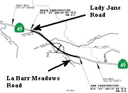 In 2007, the CTC recommended funding $18.568M from the Corridor Mobility
Improvement Account (CMIA) for the La Barr Meadows widening. In January
2008, the CTC approved the mitigated negative declaration. This project in
Nevada County will make roadway improvements that include widening from
two lanes to four lanes and construction of a new interchange along a
portion of Route 49 near Grass Valley. The project is fully funded in the
2006 State Transportation Improvement Program (STIP). The total estimated
project cost, capital and support, is $40,500,000. The project is funded
from $10,966,000 Regional Improvement Program, $10,966,000 Interregional
Improvement Program, and $18,568,000 Corridor Mobility Improvement
Account. It is estimated that construction will begin in Fiscal Year
2008-09. The project will involve construction activities in an area that
is habitat to federally protected migratory birds. The project will also
involve acquisition of new right-of-way and residential relocations.
In 2007, the CTC recommended funding $18.568M from the Corridor Mobility
Improvement Account (CMIA) for the La Barr Meadows widening. In January
2008, the CTC approved the mitigated negative declaration. This project in
Nevada County will make roadway improvements that include widening from
two lanes to four lanes and construction of a new interchange along a
portion of Route 49 near Grass Valley. The project is fully funded in the
2006 State Transportation Improvement Program (STIP). The total estimated
project cost, capital and support, is $40,500,000. The project is funded
from $10,966,000 Regional Improvement Program, $10,966,000 Interregional
Improvement Program, and $18,568,000 Corridor Mobility Improvement
Account. It is estimated that construction will begin in Fiscal Year
2008-09. The project will involve construction activities in an area that
is habitat to federally protected migratory birds. The project will also
involve acquisition of new right-of-way and residential relocations.
In March 2009, the CTC adjusted the funding on this due to increased cost. Delays in acquisition of some of the right of way parcels have led to delays in the delivery of design. Some of this was due to problems with ROW acquisition. Another problem was that the need to relinquish four new frontage roads to the County was not originally anticipated, requiring added effort in processing relinquishment activities, including a cooperative agreement, relinquishment agreement, and field surveys. These changes updated the End Design date to April 1, 2009 and the Begin Construction date to July 15, 2009.
In mid-May 2011, ground was broken on this project, which was now a $29 million project. The project will widen a 1.5-mile stretch to four lanes between Little Valley Road, just north of Alta Sierra, and Cornette Drive, south of Grass Valley. The project also includes the construction of frontage roads, right-turn projects, wider shoulders and the installation of traffic signal at La Barr Meadows Road intersection with the highway. Soundwalls will be constructed at three locations. The project is planned for completion in the fall of 2012.
In March 2013, the CTC adjusted the funding again, allocating an additional $840,000 in State Transportation Improvement Program (STIP) funds. The increase is due to a new Construction General Permit (CGP) for storm water discharges, drainage system modifications, increased traffic handling and a low asphalt price index at time of contract award plus a few miscellaneous issues.
Nevada-49 Corridor Improvement Project (03-Nev-49, PM 10.8/R 13.3)
 In August 2015, it was reported that Caltrans is studying
the feasability of a project to widen Route 49 to a four-lane highway,
with 10-foot shoulder upgrades, from Nevada County’s section of the
highway from miles 11.1 to mile 13.3. The project does not have a
definitive time line for completion, but the transportation department has
secured $6 million in funds for the feasibility and design plan. Caltrans
will seek the additional funds for construction of the project once the
design has been vetted and developed.
In August 2015, it was reported that Caltrans is studying
the feasability of a project to widen Route 49 to a four-lane highway,
with 10-foot shoulder upgrades, from Nevada County’s section of the
highway from miles 11.1 to mile 13.3. The project does not have a
definitive time line for completion, but the transportation department has
secured $6 million in funds for the feasibility and design plan. Caltrans
will seek the additional funds for construction of the project once the
design has been vetted and developed.
(Source: The Union, 8/4/2015)
The 2018 STIP, approved at the CTC March 2018 meeting, does not appear to allocate anything for this in the 2018 STIP, but does appear to show $6M allocated: $3M in prior years, and $3M in FY19-20 for Env. and Planning and PS&E.
In March 2020, the CTC approved the 2020 STIP which
adjusted the programmed funding for PPNO 4117 "La Barr - McKnight
widening" from $6,000K to $6,900K.
(Source: March 2020 CTC Agenda, Item 4.7, 2020 STIP
Adopted 3/25/2020)
In January 2022, the CTC approved for future
consideration of funding the Nevada-49 Corridor Improvement Project
(03-Nev-49, PM 10.8/R 13.3, PPNO 4117). The project is located on Route 49
from postmile 10.8 to R13.3, in Nevada County. The project proposed to
improve operations and mobility through the addition of northbound and
southbound truck climbing lanes outside an urbanized area. Caltrans
will construct a median with barrier, 10-foot shoulders, right turn lanes,
and create two at-grade access-controlled intersections. The project is
currently programmed in the 2020 State Transportation Improvement Program
(STIP) for a total of $34,100,000, which includes Right of Way (capital
and support) and Construction capital. Construction is estimated to
begin in 2026. The scope, as described for the preferred alternative, is
consistent with the project scope as programmed by the Commission in the
2020 STIP.
(Source: January 2022 CTC Agenda, Agenda Item
2.2c.(2))
Route 49 is a currently signed freeway from approximately 1 mile south of the Route 49/Route 20 interchange near Grass Valley, and runs for a length of 5 miles until reaching the Route 49/Route 20 interchange north of Nevada City (~ NEV R14.318 to NEV 15.15). This section of freeway was built in the late 60's. There are currently studies under to plan upgrading Route 49 to 4 lanes between Auburn and Grass Valley.
Scenic Route[SHC 263.4] Entire portion.
NamingMuch of this route is named the "Gold Country" Highway.
 The Route 20/Route 49 NE-bound frontage road in Grass
Valley from its intersection with South Auburn Street to its intersection
with Bennett Street (~020 NEV R12.856 to 020 NEV R13.12) is named "Hansen
Way." This segment was named in honor of the Hansen family of Grass
Valley, for their contributions to the community and for their building
supply company, Hansen Brothers, that was established in 1953. The Hansen
family historically has been very civic minded and has contributed
community service and philanthropic gifts to the community. Named by
Senate Concurrent Resolution (SCR) 10, Resolution Chapter 104, on
9/6/2005.
The Route 20/Route 49 NE-bound frontage road in Grass
Valley from its intersection with South Auburn Street to its intersection
with Bennett Street (~020 NEV R12.856 to 020 NEV R13.12) is named "Hansen
Way." This segment was named in honor of the Hansen family of Grass
Valley, for their contributions to the community and for their building
supply company, Hansen Brothers, that was established in 1953. The Hansen
family historically has been very civic minded and has contributed
community service and philanthropic gifts to the community. Named by
Senate Concurrent Resolution (SCR) 10, Resolution Chapter 104, on
9/6/2005.
(Image source: Grass Valley Downtown Assn)
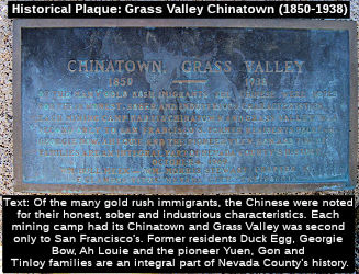 The Route 20/Route 49 SW-bound
frontage road in Grass Valley from the intersection with South Auburn
Street to Bennett Street (~020 NEV R12.856 to 020 NEV R13.12) is
officially named "Tinloy Street." This segment was named in honor
of the Tinloy family of Grass Valley. The Tinloy family has Chinese roots
and its presence in Grass Valley dates back to the 19th century. John
Tinloy was born to Kan Tinloy who immigrated to Nevada County from the
Canton Province in China during the Gold Rush in the 1880's and owned and
operated a store offering Chinese traditional food and artifacts, and this
store evolved into a social place, bank, and an employment bureau. He
married Alice Chen Shee, and together they raised one daughter and three
sons, and the family opened and operated a fine women's apparel store and
a grocery store in Grass Valley. The Tinloy family was active in the
Methodist Church in Grass Valley. The Tinloy family, stemming from the
community activism of John Tinloy, has historically been very civic minded
and contributed community service and philanthropic gifts to the
community. Named by Senate Concurrent Resolution (SCR) 11, Resolution
Chapter 121, on 9/14/2005.
The Route 20/Route 49 SW-bound
frontage road in Grass Valley from the intersection with South Auburn
Street to Bennett Street (~020 NEV R12.856 to 020 NEV R13.12) is
officially named "Tinloy Street." This segment was named in honor
of the Tinloy family of Grass Valley. The Tinloy family has Chinese roots
and its presence in Grass Valley dates back to the 19th century. John
Tinloy was born to Kan Tinloy who immigrated to Nevada County from the
Canton Province in China during the Gold Rush in the 1880's and owned and
operated a store offering Chinese traditional food and artifacts, and this
store evolved into a social place, bank, and an employment bureau. He
married Alice Chen Shee, and together they raised one daughter and three
sons, and the family opened and operated a fine women's apparel store and
a grocery store in Grass Valley. The Tinloy family was active in the
Methodist Church in Grass Valley. The Tinloy family, stemming from the
community activism of John Tinloy, has historically been very civic minded
and contributed community service and philanthropic gifts to the
community. Named by Senate Concurrent Resolution (SCR) 11, Resolution
Chapter 121, on 9/14/2005.
(Image credit: Historical Marker Database)
Named Structures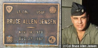 Bridge 17-0049 on Route 20, at the Route 20/Route 49
separation and Empire Street (020 NEV R012.24), is named the "Bruce
Allen Jensen, Lt. Col., USAF, Bridge". It was built in 1969, and was
named by Assembly Concurrent Resolution 43, Chapter 220, in 1971.
Lieutenant Colonel Bruce Allan Jensen was a casualty of the Vietnam War.
As a member of the Air Force, LTC Jensen served our country until August
27th, 1967 in Laos. He was 38 years old and was married. Bruce died when
his plane crashed into the land.
Bridge 17-0049 on Route 20, at the Route 20/Route 49
separation and Empire Street (020 NEV R012.24), is named the "Bruce
Allen Jensen, Lt. Col., USAF, Bridge". It was built in 1969, and was
named by Assembly Concurrent Resolution 43, Chapter 220, in 1971.
Lieutenant Colonel Bruce Allan Jensen was a casualty of the Vietnam War.
As a member of the Air Force, LTC Jensen served our country until August
27th, 1967 in Laos. He was 38 years old and was married. Bruce died when
his plane crashed into the land.
(Image Source: Virtual Vietnam Veterans Wall of Faces)
The South Yuba River Bridge over Route 49 (NEV
R21.857, South Yuba River Bridge No. 17-07) in the County of Nevada is
designated as the “Vietnam Veterans Memorial Bridge”.
It was named in memory of the men and women who served in the Vietnam War,
who had the difficult task of defending America, which they met with
courage and commitment. Named by Assembly Resolution ACR 21, Res. Chapter 107, Statutes of 2021, 09/07/21. Note: The 2006 Hallmark movie The Christmas Card depicted a Vietnam Veterans Memorial Bridge at this location, but it was filmed long before this resolution made the
designation.
(Source: Movie Information - Nevada City Chamber of Commerce)
Freeway[SHC 253.4] Entire portion. Added to the Freeway and Expressway system in 1959.
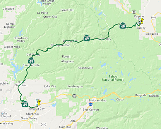 (5) From Route 20 at Nevada City to Route 89 near Sattley via Downieville.
Post 1964 Signage HistoryThis segment is as defined in 1963.
The route between Route 20 near Grass Valley and Route 20 near Nevada City is signed as Route 49, although it is legislatively Route 20.
Pre 1964 Signage HistoryIn 1934, Route 49 was signed along the route from Jct Route 140 at Mariposa to Jct. Route 24 (now Route 70) near Reno Jct, via Sonora, Jackson, and Nevada City. It was LRN 25. The portion from Route 20 to Downieville was defined in 1909; the portion from Downieville to Route 89 was defined in 1933.
Downieville
The 1909 bond act established Downieville as the N end
of LRN 25 (future Sign Route 49), and a road between Nevada City and
Downieville was shown on the 1918 CHC map. Traffic continuing E to Yuba
Pass would utilize the Jersey Bridge of the time. The original Jersey
Bridge was the site of the known only hanging of a woman in California
history, which took place on July 5, 1851, when an individual only known
as Juanita was executed at the structure. The original Jersey Bridge was
partially destroyed by a flood during the 1880s but was ultimately
rebuilt. The load capacity of the original Jersey Bridge is cited to
have been rated for 8,000 pounds.
(Source: Gribblenation Blog (Tom Fearer), "The alignment history of California State Route 49 in Downieville", February 2023)
The route was extended to Yuba City in 1933, and signed
as Sign Route 49 during 1934. At this time, it was aligned over the
original Jersey Bridge. Route 49 was shifted to a new alignment
downstream on the Downie River near the confluence of the North Fork River
during 1936 via a concrete bridge. The new alignment of Route 49 bypassed
much of Main Street and Commercial Street in downtown Downieville, in
favor of an alignment much closer to the Downie River/North Fork Yuba
River confluence. The new concrete bridge is described as carrying a
24-foot-wide road deck. The new bridge over the Downie River was
destroyed in a flood during December 1937. The original Jersey Bridge and
Durgan Bridge were also destroyed by the flood waters. The floods of 1937
shifted the alignment of the Route 49 back into downtown Downieville via
Main Street and Commercial Street to avoid the confluence of the Downie
River/North Fork River. A new iteration of the Jersey Bridge constructed
during 1938. The 1938 Jersey Bridge and Commercial Street comprise the
only one-lane component of Route 49. The remaining part of the 1936
alignment of Route 49 south of the Downie River is now known as Old
Highway.
(Source: Gribblenation Blog (Tom Fearer), "The alignment history of California State Route 49 in Downieville", February 2023)
In a discussion on AARoads, Nathan Edgars (NE2), Scott Parker (Sparker)
and Tom Feaerer (Max R) provide more history: With respect to Route 49
from Sierra City north to Route 70, it would seem that much like Route 180, Route 49 was actually signed on roadways in Sierra County that were
not under state maintenance (at least in 1938). The alignment doesn't
appear to be very different than modern Route 49. The 1935 Sierra and
Pulmas County Maps shows that the alignment between Sierraville and modern
Route 70 was county maintained at the time.By 1940,Route 49 is not shown
as existing between Sierraville and modern Route 70. The map is not
detailed enough to tell if Route 49 still ended in Sierraville or was cut
back to Yuba Pass at Route 89. By 1954 an implied new alignment of LRN 233
appears on the State Highway Map running from Sierraville to modern Route 70. The implied aligmment is much straighter than the existing roads or
how Route 49 turned out to be. By 1958 the new alignment appears to have
been abandoned and the State Highway Map shows that Route 49 is officially
state maintained on the previous county roads it occupied.
(Source: AARoads Discussion, June 2017)
StatusThe route between Sattley and Sierraville is signed as Route 49, although it is legislatively Route 89. This results in signs for 49 North and 89 South ... and the reverse of this going the other way.
In August 2011, the CTC approved $18,800,000 in SHOPP funding for repairs in and near Downieville, from 0.3 mile south of Downie River Bridge to 0.2 mile north of Yuba Pass camp ground (~ SIE 16.301 to SIE 40.918) that will rehabilitate 25.2 lane miles of roadway to improve the ride quality, prevent further deterioration of the road surface, minimize the costly roadway repairs and extend the pavement service life.
Downieville Side Hill Viaduct (~ SIE 16.823)
In June 2019, the CTC approved the following SHOPP
scope amendment: 03-Sie-49 Var PPNO 7809 ProjID 0318000176. Route 49 Near
Downieville (~ SIE 16.823), at various locations. Permanent embankment
restoration by reconstructing the existing lane adjacent to river as
a side hill viaduct placing Rock Slope Protection (RSP).
Project scope and description have changed to simplify project
construction and traveler impacts. A side hill viaduct will now be
constructed instead of placing 8-ton rock slope protection, which would
have required the use of a large crane resulting in roadway closure and
detour of 42 days. Due to the change in scope, the construction support
has increased and R/W capital has decreased. Updated total cost: $15,625K.
(Source: June 2019 CTC Minutes, Agenda Item
2.1a.(1) Scope Item 35)
In June 2019, the CTC approved the following support
phase allocation: $1,189,000 03-Sierra-49 Var PPNO 7809 ProjID 0318000176
Route 49 Near Downieville, at various locations. Permanent embankment
restoration by reconstructing the existing lane adjacent to river as a
side hill viaduct. PS&E $1,099,000 R/W Support $90,000. (Concurrent
amendment under SHOPP Amendment 18H-010.)
(Source June 2019 CTC Minutes, Agenda Item
2.5b.(2a) Item 16)
In May 2020, the CTC was informed of the following SHOPP Safety
Allocation that was made in March 2020: $2,576,000 03-Sie-49 44.1/44.4.
PPNO 03-7807 ProjID 0317000341 EA 3H400. Route 49 near Sierraville, from
2.9 miles to 3.2 miles north of Yuba Pass Campground. Outcome/Output:
Improve safety by realigning roadway, correcting cross slope, and widening
shoulders. This project will reduce the number and severity of collisions.
Allocation Date: 03/23/20.
(Source: May 2020 CTC Agenda, Agenda Item 2.5f.(3)
#5)
Scenic Route[SHC 263.4] Entire portion.
Freeway[SHC 253.4] Entire portion. Added to the Freeway and Expressway system in 1959.
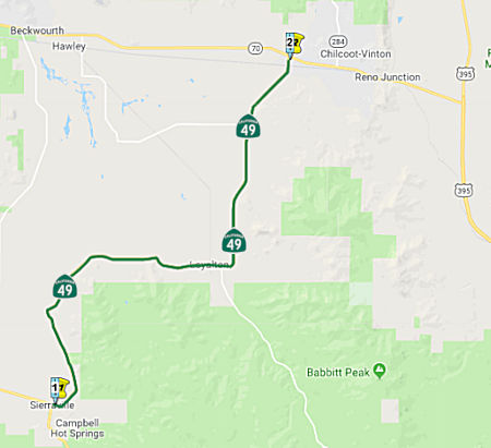 (6) From Route 89 near Sierraville to Route 70 near Vinton via Loyalton.
Post 1964 Signage HistoryThis segment is as defined in 1963.
The route between Satley and Sierraville is signed as Route 49, although it is legislatively Route 89.
Pre 1964 Signage HistoryIn 1934, Route 49 was signed along the route from Jct Route 140 at Mariposa to Jct. Route 24 (now Route 70) near Reno Jct, via Sonora, Jackson, and Nevada City. Route 70 was Alternate US 40 before 1964, and at one point was signed as Route 24.
In a discussion on AARoads, Nathan Edgars (NE2), Scott Parker (Sparker)
and Tom Feaerer (Max R) provide more history: With respect to the segment
from Route 89 to former LRN 36/Route 194, Yuba Pass is probably one of the
easier passes of the Sierras in the current state highway system. The pass
was only showing 5% grades, and is only 6,709 feet which is on the lower
side of the mountain passes. LRN 36 was part of the original state highway
system and terminated at Saddleback Mountain. Apparently LRN 36 was meant
to service the mining district north of Downieville which is odd
considering the town had long since declined well before the 1930s. LRN 36
was briefly renumbered to CA 194 in 1964 before being deleted from the
state highway system which is first reflected on the 1966 state highway
map. Route 194 was deleted in 1965 along with several other short routes
and urban connectors, including the original Route 215 along Garey Ave. in
Pomona. Ironically, when I-15E was commissioned in 1973, Caltrans re-used
the CA 194 designation as a "placeholder" for the suffixed route -- and 9
years later both designations (signed suffix and legally defined state
highway) were dropped in favor of I-215. The original intended purpose of
LRN 36 was to connect Downieville to Mount Pleasant on the old road
between Quincy and Marysville (Port Wine Ridge Road), giving Downieville
another outlet to the rest of the world. But Port Wine Ridge Road was
never taken over by the state, and neither was much of LRN 36. The concept
of LRN 36 intersecting a route to Quincy (originating in 1907) was laid to
rest two years in 1909 later when a subsequent state bond issue authorized
LRN 30, which took a more northerly route beginning in Oroville rather
than Marysville. Part of that route is the easternmost portion of present
Route 162, which terminates east of Lake Oroville. LRN 30 itself was
short-lived; the Division of Highways opted to extend LRN 21, then simply
a Richvale-Oroville connector, up the Feather River canyon via what was
mostly the then-WP service road, as LRN 30 featured severe grades and
treacherous canyon-side perches, whereas the Feather River alignment more
or less mimicked the rail line's relatively benign 1% gradient. LRN 30 was
deleted by the 1930's and its alignment east of Quincy subsumed by an
extended LRN 21; the entire route east of Oroville was signed as Route 24
and redesignated as Alternate US 40 in 1954-55 after a couple of severe
winters caused long closures of US 40 over Donner Pass. Another factor in
why LRN 36 really never was fully completely was the plunge in population
in Sierra County in the 20th Century. Sierra County would have had about
4,000 residents between 1900 to 1910 and only somewhere in the
neighborhood of 2,500 by the time the Signed State Highway era began in
the 1930s. Given the population barely moved from that point through the
rest of the 20th century really would have put LRN 36 low on the totem
pull considering the diminishing stature of Sierra County after the mining
heyday was long over. Really though, Yuba Pass and Route 89 turned out to
be a very viable route to get to Quincy from Downieville not to mention
that now there is also the Gold Lake Highway which cuts out some mileage
northbound. According to rail historians, much of the labor force that
built the WP line up the Feather River and across northern Nevada was
composed of former miners laid off from played-out diggings in the
northern Sierra; their experience with often dangerous underground
situations paid off when the line had to tunnel through obstacles. One
particular problem was the long (a bit over a mile) Spring Garden tunnel,
which bored beneath a ridge separating two branches of the upper Feather
River between Quincy and Blairsden. Since tunnel construction, even in the
early 1900's, was still a labor-intensive (dig, blast, clear, repeat)
process, problems that may have vexed the line's engineers were "old hat"
to many of these former miners -- the Spring Garden dig encountered
several underground streams that had to be either diverted or channeled --
usually the latter, where the tunnel was made wide enough to accommodate
"gutters" on each side of slightly raised track bed to deal with the
runoff (a common practice in Sierra gold mines and adapted for this
purpose). That tunnel is still in service today -- significantly enlarged
to handle double-stack container traffic that won't fit under Donner
snowsheds -- but still experiences occasional water issues during very
rainy seasons. LRN 36 remained in the state system until the widespread
deletions of 1965, although its purpose had essentially evaporated over
the previous half-century. LRN 36 was always a bit of an "outlier" in the
network; but for a long time there were recurring local rumblings about
the need for a direct route north to Quincy and the upper Feather River
area independent of a ridge-bound E-W facility; these kept the concept on
"life support" -- but after decades of inaction, the Division of Highways
finally decided to pull the plug and delete the successor Route 194.
(Source: AARoads Discussion, June 2017)
Freeway[SHC 253.4] Entire portion. Added to the Freeway and Expressway system in 1959.
 Interregional Route
 Classified Landcaped Freeway
The following segments are designated as Classified Landscaped Freeway:
| County | Route | Starting PM | Ending PM |
| Nevada | 49 | R13.26 | R13.45 |
| Nevada | 49 | R13.54 | R14.47 |
 Other WWW Links Pre 1964 Signage History
Route 49 was signed as part of the initial state signage of routes in 1934.
 Statistics
Overall statistics for Route 49:
 Pre-1964 Legislative Route
The route that would become LRN 49 was first defined in the 1919 Third Bond Act as running from Calistoga to Lower Lake. It was extended in 1933 from [LRN 8] near Napa to [LRN 49] near Calistoga. It was codified in the 1935 state highway code as:
"[LRN 8] near Napa to [LRN 15] via Calistoga and Lower Lake"
It remained unchanged until the 1963 renumbering. This was signed as Route 29 in two segments:
© 1996-2020 Daniel P. Faigin.
Maintained by: Daniel P. Faigin
<webmaster@cahighways.org>.
 Route 48
 Route 50