
 California Highways:
Click here for a key to the symbols used. An explanation of acronyms may be found at the bottom of the page.
 Routing
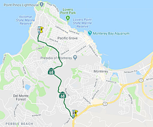 (a) (1) From Asilomar State Beach to Route 1.
(b) (1) Upon a determination by the commission that it is in the best interests of the state to do so, the commission may, upon terms and conditions approved by it, relinquish to the City of Pacific Grove or the County of Monterey the portion of Route 68 described in paragraph (1) of subdivision (a) located within the jurisdiction of the city or the unincorporated area of the county, respectively, if the department and the city or county enter into an agreement providing for that relinquishment.
(2) A relinquishment under this subdivision shall become effective immediately following the county recorder’s recordation of the relinquishment resolution concerning the commission’s approval of the terms and conditions of the relinquishment.
(3) On and after the effective date of the relinquishment, both of the following shall occur:
(A) The portion of Route 68 relinquished under this subdivision shall cease to be a state highway.
(B) The portion of Route 68 relinquished under this subdivision shall be ineligible for future adoption under Section 81.
(4) The city or county shall ensure the continuity of traffic flow on the relinquished former portion of Route 68 within its jurisdiction, including, but not limited to, any traffic signal progression.
(5) The city or county shall maintain signs on the relinquished former portion of Route 68 within its jurisdiction directing motorists to the continuation of Route 68.
 Post 1964 Signage History
As defined in 1963, this segment ran from "Asilomar Beach State Park to Route 1"
In 1992, Chapter 1243 changed "Beach State Park" to "State Beach"
In 2013, Chapter 525 (SB 788, 10/9/13) added section (b) permitting relinquishment of segment (1) in the City of Pacific Grove or the County of Monterey.
 Pre 1964 Signage History
This segment was LRN 262, defined in 1959. It was not signed as part of the initial 1934 state signing. It was also not part of the 1961 definition of state sign Route 68. In late 1964, the CHC adopted 4.1 miles of local roads and streets in the Monterey-Pacific Grove area as a new section of Route 68, extending between Route 1 at the Carmel Hill Interchange and Asilomar Beach State Park.
The route ends at Asilomar State Beach, which is part of the Asilomar Conference Center. This center was built in 1913 by the YWCA, and was deeded to the State of California Park System in 1956.
Tom Fearer over on the Gribblenation Blog investigated the history of LRN 117, and noted the following:
 Status
Collision Severity Reduction program project (PPNO 2378) on Route 68 (05-Mon-68 1.6/L4.02)
In June 2018, the CTC approved a request for an
additional $383,300 in Capital Outlay Support (Support Cost) for the State
Highway Operation Protection Program (SHOPP) Collision Severity Reduction
program project (PPNO 2378) on Route 68, in Monterey County for a revised
amount of $1,476,300. The project is located in Monterey County, on Route 68 from south of Piedmont Avenue to the Scenic Drive Overcrossing (Bridge
No. 44-0041), in and near Pacific Grove. The project will improve the
safety and operation of Route 68 at various locations in Monterey County.
The scope of work for this project includes shoulder widening,
installation of rumble strips, drainage improvements, retaining wall,
pavement restriping, improvements to signage, the upgrading of existing
guardrail systems and the placement of tapered edge with shoulder backing.
In addition, where possible, 5 and 8 foot outside shoulders will be
constructed to provide safer bicycle travel. The reason for the cost
increase request is that, during the Project Approval and Environmental
Document (PA&ED) phase, the Department assumed that a
telecommunications utility vault next to the existing bridge columns would
be relocated by the utility owner under the Pacific Grove centerline
rumble strip project (PPNO 2604); which is within the same project limits
and would start construction prior to this contract. However, the project
(PPNO 2604) later deferred the utility vault relocation to this project
and was not discovered until PS&E that the utility vault contains a
significant amount of fiber optic cables that could not be cut and
spliced. The relocation of the telecommunications utility vault would
increase the project capital costs by an estimated $1,000,000, and
required conductors to be as long as 9,000 linear feet, and caused service
disruptions to local government, businesses, and residents. The Department
decided to redesign the concrete barrier rail in front of the existing
bridge columns, allowing for the utility vault to stay in place and
maintain access through the existing manhole. This resulted in
unanticipated design changes, which included the adjustment and
replacement of drainage facilities. Around the utility vault, there is a
deep gully leading to an existing drainage inlet. In order to accommodate
the concrete barrier redesign around the utility vault, a drainage inlet
was modified, the shoulder to the uphill slope was widened, and runoff was
channeled by installation of a dike. The amount expended for the re-design
of the concrete barrier and drainage change was $165,000. The Department
received a design exception for corner sight distance in the PA&ED
phase. However during PS&E, a property owner near an intersection on
Route 68, within the project limits, contacted the Department’s
Maintenance staff via phone call regarding corner sight distance concerns.
This location was reinvestigated and the Department determined that a
design change to slightly modify both legs of the intersection, removal of
three trees, and grading of the hillside was required to improve corner
sight distance. In addition, to address the corner site distance, a minor
shoulder widening was required for 200 feet to capture runoff toward a new
drainage inlet. The corner sight distance improvements also required the
evaluation for tree removal, and design and landscape architecture efforts
to determine the plant mitigation of 30 tree plantings within the
Department’s right of way. The amount expended for the corner site
distance improvement was $99,000. This request also includes the remaining
work in the PS&E phase to allow the Department to bring the project to
RTL and to complete work to advertise, award, and approve the contract,
including contractor outreach, bidder inquiries, and preparation of work
for the begin of the construction phase. The estimated support costs for
the remaining work is $119,300.
(Source: June 2018 CTC Minutes, Agenda Item 2.5e(2))
In January 2019, the CTC approved a request for an
additional $952,000 for the State Highway Operation Protection Program
(SHOPP) Collision Severity Reduction project (PPNO 2378) on State Route (SR) 68, in Monterey County, to award the construction contract. The
reason for the cost increase was that the Engineers' Estimate from June
undervalued costs in three areas: the concrete barrier, the costs for
night work in a limited area, and the construction market.
(Source: January 2019 CTC Minutes, Agenda Item 2.5e(1))
Roadway Improvements - Skyline Forest Dr to Rte 1
In August 2018, the CTC added the following project
into the 2018 SHOPP: 05-Mon-68 3.4/3.8 PPNO 2742, Project 0517000113, EA
1J460 Route 68 Near Pacific Grove, from Skyline Forest Drive to west of
Route 1; also from Haul Road to west of Skyline Forest Drive (PM 2.7/3.2).
Increase safety by improving roadway cross slope at curve, sight distance,
widen shoulders, install rumble strip, tapered edge treatment and
construct drainage improvements. Expected cost: $12,427,000 Construction
begins 1/24/2023.
(Source: August 2018 CTC Agenda Item 2.1a.(1))
The 2020 SHOPP, approved in May 2020, included the
following Collision Reduction item of interest (carried over from the 2018
SHOPP): 05-Monterey-68 PM 3.4/3.8 PPNO 2742 Proj ID 0517000113 EA 1J460.
Route 68 near Pacific Grove, from Skyline Forest Drive to west of Route 1;
also from Haul Road to west of Skyline Forest Drive (PM 2.7/3.2). Increase
safety by improving roadway cross slope at curve, sight distance, widen
shoulders, install rumble strip, tapered edge treatment and construct
drainage improvements. Programmed in FY21-22, with construction scheduled
to start at the end of January 2023. Total project cost is $12,427K, with
$7,280K being capital (const and right of way) and $5,147K being support
(engineering, environmental, etc.).
(Source: 2020 Approved SHOPP a/o May 2020)
In December 2020, the CTC approved the following SHOPP
Support Phase allocation: $1,891,000 ($2,053,000 programmed) for PS&E
and $328,000 ($356,000 programmed) for R/W Sup for 05-Mon-68 PM 3.4/3.8.
PPNO 05-2742 ProjID 0517000113 EA 1J460. Route 68 Near Pacific Grove, from
Skyline Forest Drive to west of Route 1; also from Haul Road to west of
Skyline Forest Drive (PM 2.7/3.2). Increase safety by improving
roadway cross slope at curve, sight distance, widen shoulders, install
rumble strip, tapered edge treatment and construct drainage improvements.
(Source: December 2020 CTC Agenda, Agenda Item
2.5b.(2a) #14)
In January 2021, the CTC approved the following SHOPP
amendment: (1b) #10. 05-Mon-68 3.4/3.8 PPNO 2742 ProjID 0517000113 EA
1J460. Route 68 Near Pacific Grove, from Skyline Forest Drive to west of
Route 1; also from Haul Road to west of Skyline Forest Drive (PM 2.7/3.2).
Increase safety by improving roadway cross slope at curve, sight distance,
widen shoulders, install rumble strip, tapered edge treatment and
construct drainage improvements. It has been determined that construction
of a planned retaining wall will not be needed. This change resulted
in a decrease to construction support with less working days, a decrease
in required right of way capital, and a decrease in construction capital.
The project was reduced from a total of $12,427K to $8,515K.
(Source: January 2021 CTC Agenda, Agenda Item
2.1a.(1b) #10)
Holman Roundabout Interchange Improvements (~ MON L4.214)
In July 2005, the CTC considered funding to widen from 2 lanes to 4 lanes and improve intersection on Route 68 west of Community Hospital of Monterey Peninsula entrance to Route 1/Route 68 Junction.
In June 2009, the CTC approved for future consideration of funding a project that will widen and upgrade Route 68 from just west of the Community Hospital of Monterey entrance to the Route 1/Route 68 interchange. The project is not fully funded. The project is programmed in the 2008 State Transportation Improvement Program (STIP) for $100,000 for right of way. The project is proposed to be funded primarily by private development sources, the City of Monterey, and future Transportation Agency for Monterey County STIP shares. The total estimated cost is $21,170,000, capital and support. Depending on the availability of funding, construction is estimated to begin in Fiscal Year 2010-11.
In January 2018, it was reported that a ribbon-cutting
ceremony occured for the completion of the Holman Highway 68 Roundabout
Project was held on Thursday, October 12, 2017. Elected officials,
community members and representatives from the Transportation Agency for
Monterey County, Caltrans, Harris & Associates, Granite Construction,
Pebble Beach Company, Community Hospital of the Monterey Peninsula and the
Monterey Bay Unified Air Pollution Control District, gathered on the
sidewalk near the roundabout to celebrate the occasion. The project which
was a public-private partnership between the City of Monterey, City of
Pacific Grove, Pebble Beach Company, the Monterey Bay Unified Air
Pollution Control District, the County of Monterey, Caltrans and TAMC was
designed to relieve congestion near the Route 68/Route 1 intersection and
improve access to the Community Hospital, Pacific Grove, Monterey and
Pebble Beach. It is the first highway to highway roundabout in Monterey
County.
(Source: Transporation Agency for Monterey County, January 2018)
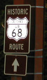 David Markowitz reported an interesting mis-signage on
Route 68. Apparently, either a contractor or a guerilla art project has
put up a "Historic Route 68" sign...with the wrong shield, on a segment
that has never been authorized for historic signing. It is unclear where
the sign came from.
David Markowitz reported an interesting mis-signage on
Route 68. Apparently, either a contractor or a guerilla art project has
put up a "Historic Route 68" sign...with the wrong shield, on a segment
that has never been authorized for historic signing. It is unclear where
the sign came from.
 Naming
 This segment (~ MON 0.0 to MON 4.166) is named "W. R. Holman Highway". Named in honor of Wilford Rensselaer Holman. Holman
was the son of Rensselaer Luther Holman, who was born in Underhill,
Vermont, and first came to California around the Horn in 1850. He had
developed a hardware and implement business in Sacramento but in 1886 he
moved to Pacific Grove where, in 1891 in company with G. W, Towle, he
developed a department store which later, under the ownership of Holman's
sons, Wilford and Clarence, became Holman's Department Store. In 1985 the
store was purchased by a Watsonville department store and today is known
as Ford's of Monterey Bay. W. R. Holman also became know for his interest
in holly. At Holly Hills Ranch, near Watsonville, Santa Cruz County, he
turned his hobby into the largest single planting of holly in the world.
He was born August 28, 1884, and died December 1981. Holman married Zena
Patrick in 1912; she died in 1980. The highway was named in 1976. As for
the road itself, Holman and Julia Platt were largely responsible for
advocating the creation of a new road to improve travel between Carmel and
Pacific Grove. The highway had other names such as the Pacific Grove 'cut
off' or the "Carmel Cut-Off".
This segment (~ MON 0.0 to MON 4.166) is named "W. R. Holman Highway". Named in honor of Wilford Rensselaer Holman. Holman
was the son of Rensselaer Luther Holman, who was born in Underhill,
Vermont, and first came to California around the Horn in 1850. He had
developed a hardware and implement business in Sacramento but in 1886 he
moved to Pacific Grove where, in 1891 in company with G. W, Towle, he
developed a department store which later, under the ownership of Holman's
sons, Wilford and Clarence, became Holman's Department Store. In 1985 the
store was purchased by a Watsonville department store and today is known
as Ford's of Monterey Bay. W. R. Holman also became know for his interest
in holly. At Holly Hills Ranch, near Watsonville, Santa Cruz County, he
turned his hobby into the largest single planting of holly in the world.
He was born August 28, 1884, and died December 1981. Holman married Zena
Patrick in 1912; she died in 1980. The highway was named in 1976. As for
the road itself, Holman and Julia Platt were largely responsible for
advocating the creation of a new road to improve travel between Carmel and
Pacific Grove. The highway had other names such as the Pacific Grove 'cut
off' or the "Carmel Cut-Off".
(Source: Monterey/Carmel Historical Society; Image
source: AAroads, Mayo Hayes O'Donnell Library)
 The portion of Route 68
located between Morse Drive (MON 2.26) and Skyline Forest Drive (MON 3.37)
in the County of Monterey is named the “Army Specialist Roger
Lee Memorial Highway”. It was named in memory of United
States Army Specialist Roger Lee of Monterey, California, who was killed
in action on July 6, 2010, along with two others in an attack on their
vehicle by insurgents with an improvised explosive device in Qalat,
Afghanistan. Lee was assigned to the 1st Battalion, 4th Infantry Regiment,
based in Hohenfels, Germany, and deployed to Afghanistan as part of
Operation Enduring Freedom. Lee was a native of Monterey, California, and
graduated from Monterey High School. Before joining the United States
Army, Lee worked as an automobile mechanic and lived on the central coast.
Named by Assembly Resolution ACR 203, Res. Chapter 166, 08/30/22.
The portion of Route 68
located between Morse Drive (MON 2.26) and Skyline Forest Drive (MON 3.37)
in the County of Monterey is named the “Army Specialist Roger
Lee Memorial Highway”. It was named in memory of United
States Army Specialist Roger Lee of Monterey, California, who was killed
in action on July 6, 2010, along with two others in an attack on their
vehicle by insurgents with an improvised explosive device in Qalat,
Afghanistan. Lee was assigned to the 1st Battalion, 4th Infantry Regiment,
based in Hohenfels, Germany, and deployed to Afghanistan as part of
Operation Enduring Freedom. Lee was a native of Monterey, California, and
graduated from Monterey High School. Before joining the United States
Army, Lee worked as an automobile mechanic and lived on the central coast.
Named by Assembly Resolution ACR 203, Res. Chapter 166, 08/30/22.
(Image source: IraqWarHeroes)
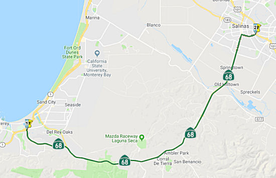 (a) (2) From Monterey to Route 101 in Salinas.
Post 1964 Signage HistoryAs defined in 1963, this segment ran to "Route 101 near Salinas". In 1992, Chapter 1243 changed "near Salinas" to "in Salinas"
This is constructed to freeway standards for 2 miles either direction from the Salinas River Bridge south of Salinas. The original plan was to construct a freeway alignment bypassing Salinas to the west, then rejoining the current Route 68 alignment (Main Street) at Hunters Lane. The routing would have involved a split with the US 101 freeway one mile northwest of the current Main Street (Business Route 101/Route 183) interchange, close to the current Laurel Drive/Davis Road interchange. Route 68 would have continued south on Davis Road past Blanco Road, at which point it would turn southeast to meet up with Main Street, then continue southwest on Main Street from Hunters Lane to the current freeway alignment. Two vestiges of this planned routing remain in Salinas:
 In 1974, the CHC declared its intention to rescind the freeway adoption of Route 68: a
5.4 mi segment from Foster Road to US 101 near Salinas.
In 1974, the CHC declared its intention to rescind the freeway adoption of Route 68: a
5.4 mi segment from Foster Road to US 101 near Salinas.
(Source: The Californian, 9/23/1974 via Joel Windmiller, 2/25/2023)
According to Sean Torgson, the sign bridges on US 101 in Salinas, before the Route 68 exit, have an off-centered control destination that reads 'Monterey Pennisula'. In one case it looks as if a potential Route 68 shield is covered up w/ a 'RAMP 25 MPH' sign. He speculates that this to directly connect to a Route 68 freeway, but since it wasn't constructed, they left the shields off.
Pre 1964 Signage HistoryThis route was LRN 117, defined in 1933. It was not signed as part of the initial 1934 state signing. Sign Route 68 was defined by the CHC in 1961. Tom Fearer over on the Gribblenation Blog investigated the history of LRN 117, and noted the following:
StatusIn August 2011, the CTC approved $3,478,000 in SHOPP funding for repairs near the city of Monterey, from Route 1 to 0.3 mile west of Laureless Grade (~ MON R4.000 to MON 10.917), that will rehabilitate 13.7 lane miles of roadway to improve the ride quality and prevent further deterioration of the road surface.
Route 68 Corridor Improvement Project: Monterey/Josselyn Canyon to Salinas/Spreckels Blvd (05-Mon-68 PM 4.8/13.7)
 The 2018 STIP, approved at the CTC March 2018 meeting, appears to allocate $8,400K for PPNO 1790, Rt 68 Op Improvements,Josselyn Cnyn-Spreckels Blvd, ~ MON
5.227 to MON R18.077.
The 2018 STIP, approved at the CTC March 2018 meeting, appears to allocate $8,400K for PPNO 1790, Rt 68 Op Improvements,Josselyn Cnyn-Spreckels Blvd, ~ MON
5.227 to MON R18.077.
In October 2019, it was reported that Caltrans has
released details on a Route 68 Corridor Improvement Project: specifically,
Caltrans is exploring the possibility of placing one or multiple
roundabouts at intersections between Josselyn Canyon Road (~ MON 5.224)
and San Benancio Road (~ MON 13.323). There are potentially nine
intersections impacted. The other possibility is simply improving on the
lighted intersections already present on that stretch of the highway. The
preference of residents is widening Route 68 or adding a lane through
larger portions of the road. Caltrans is also looking into providing safe
wildlife crossings along the highway. Estimated time period is 2023.
(Source: 8">KION 5/46, 10/3/2019)
In March 2020, the CTC approved the 2020 STIP, which
adjusted the programmed funding and title of PPNO 1790 "Op Improvements,
Josselyn Cnyn-Spreckels Blvd (tech change)" to "Op Improvements,Josselyn
Cnyn-San Benancio Rd", with funding adjusted from $3,400K to $22,003K,
with $18,603K of that funding programmed for FY22-23.
(Source: March 2020 CTC Agenda, Item 4.7, 2020 STIP
Adopted 3/25/2020)
In July 2023, it was reported that Caltrans was holding
an “open house” to provide the public with an update on the
Route 68 Corridor Improvement Project. The Scenic Route 68 Corridor
Improvement Project aims to improve safety for motorists and wildlife and
improve traffic flow along about 10 miles of Route 68 between Monterey and
Salinas. The Route 68 Scenic Highway Plan was funded with a Caltrans
Sustainable Communities Transportation Planning Grant. It evaluates
current and future travel patterns between Salinas and the Monterey
Peninsula, the feasibility of affordable mid-term operational and capacity
improvements in the Route 68 corridor in context to other planning
regional improvements serving the same commute market and the potential
for wildlife connectivity enhancements. Work on this plan started in
December 2015 and was completed in August 2017. Its stated goals are to
improve safety, access, operations and wildlife connectivity, while
reducing congestion and greenhouse gas emissions. The concept recommends
converting 11 intersections to roundabout control between Salinas and
Monterey, restricting left turns out of side streets and driveways to
improve safety, improving access at the Laguna Seca and SPCA area via
striping then roundabout access, evaluating widening between Corral de
Tierra and San Benancio Road roundabouts, installing dynamic speed
feedback signs and intersection warning signs and constructing wildlife
connectivity improvements. Planning level cost estimates of the corridor
concept is $48.22 million plus an additional $21.4 million for wildlife
connectivity improvements.
(Source: Monterey Herald, 7/17/2023)
The project page for the project provides more
information on the plans. Caltrans in partnership with the Transportation
Agency for Monterey County proposes to improve intersection operations
along Route 68 between Josselyn Canyon Road and San Benancio Road (post
miles 4.8 -13.7) in order to reduce travel delays and vehicle collisions;
and enhance wildlife connectivity to further reduce collisions between
wildlife and vehicles. Caltrans will be the lead agency and will
prepare an environmental impact report for the project. The proposed
project provides two build alternatives which would either covert
intersections into roundabouts (Alternative 1) OR make modifications to
the existing signalized intersection configuration (Alternative 2) at the
following nine intersections. Each of the two proposed build alternatives
also include wildlife crossing improvements to existing culverts at five
locations to deter wildlife from entering Route 68. A No-Build
alternative will also be evaluated.
(Source: Corridor Improvement Program Project Page, 9/10/2023)
The Estimated Project Timeline includes Public Scoping
- October – November 2019; Draft Environmental Document (DED)
release – Fall 2023; DED Public Hearing – Fall 2023; Approve
Final Environmental Document – Summer 2024; Design and Permitting
– 2024-2026; Right of way acquisitions and utilities initiated
– Summer 2025; and the start of construction in Fall 2027.
(Source: Corridor Improvement Program Project Page, 9/10/2023)
Corral de Tierra Project (PM MON 12.8/13.2)
In June 2013, the CTC approved delaying RIP funding for construction from FY 2013-14 to FY 2014-15 for the Route 68 Safety and Operations Corral de Tierra project (PPNO 1813A) in Monterey County. This project will construct turn lanes, shoulder widening and driveway realignment at the Corral de Tierra Road intersection. It is programmed with $1,700,000 of RIP funds for construction in FY 2013-14.
In March 2016, the CTC approved for future consideration of funding a project that will construct turn lanes, merge lanes, and other improvements to the intersection of Route 68 and Corral de Tierra Road near the city of Salinas. The project is programmed in the State Transportation Improvement Program. The total estimated cost is $2,250,000 for capital and support. Construction is estimated to begin in Fiscal Year 2016-17. The scope, as described for the preferred alternative, is consistent with the project scope programmed by the Commission in the 2014 State Transportation Improvement Program. A copy of the MND has been provided to Commission staff. The project will result in less than significant impacts to the environment after mitigation. The following resource area may be impacted by the project: biological resources. Avoidance and minimization measures will reduce any potential effects on the environment. These measures include, but are not limited to, ESA fencing to be installed around sensitive areas, project area will be revegetated with native species, preconstruction surveys to be conducted for nesting birds and estivating California tiger salamanders, and loss of California tiger salamander habitat to be mitigated at a 1:1 ratio. As a result, an MND was completed for this project.
In June 2017, the CTC approved delaying construction on this project until FY 2017-18 to 2018-19. The environmental document was completed in 2015, the design is 95 percent complete and right of way is nearly complete. There is currently a corridor study for Route 68 that encompasses this project. The study addresses the ultimate needs and improvements for the corridor. The county was successful in November 2016 in passage of a measure to fund transportation projects, which included $50 million for this project location. With the passage of the measure, there is the desire to delay the construction of the project to allow time to assess the study and determine if there is an opportunity for leveraging additional funds for ultimate improvements in the corridor. In order to review and consider the corridor study, the county along with TAMC are requesting to move construction. This change could further benefit the corridor by allowing the parties to consider options with the current project scope, as well as coordinate with the corridor study, and facilitating the potential to match funds and opportunities for enhancement for the ultimate improvements.
The 2018 STIP, approved at the CTC March 2018 meeting, appears to delete $1,700K in funding from the Corral de Tierra Project. The project will improve safety and traffic flow at the Highway 68 and Corral De Tierra intersection by adding dual left turn lanes from westbound Hwy 68, adding a southbound merge lane and a northbound right turn lane on Corral De Tierra, and adding a fourth leg to the intersection.
In July 2010, the CTC approved for future consideration of funding a project that will construct roadway improvements including intersection improvements and bridge widening at San Benancio Road (~ MON 13.289) near the city of Monterey. The project is programmed in the 2010 State Transportation Improvement Program and includes local funds. Construction is estimated to begin in Fiscal Year 2010-11. Total estimated project cost is $5,401,000 for capital and support.
In October 2012, the CTC approved for future consideration of funding 05-Mon-68, PM 17.7/17.9 Route 68 Salinas River Bridge Widening Project. This project in Monterey County will bring the Salinas River Bridge up to current geometric and seismic standards by widening shoulders, adding approach and departure slabs, improving acceleration and weaving lane geometry, improving the bridge railing, seismically retrofitting the bridge, and providing maintenance access to the river bottom.
In May 2015, it was reported that Caltrans has Sustainable Transportation Planning Grant funding to the Transportation Agency for Monterey County for its State Route 68 Corridor Plan, which will determine operational and capacity improvements affordable over the next 5 to 20 years that contribute to the long-range sustainability of Route 68.
Naming The segment of Route 68 between Anza Drive in the County of Monterey and Blanco Road
in the City of Salinas (~ MON 15.896 to MON 19.955) is officially named
the "Ohlone Costanoan Esselen Highway." It was named in honor of
the Esselen people, who have been indigenous to the Greater Monterey
County area for more than 10,000 years.From their known ancestral tribal
villages from the coast and inland, the Esselen people hunted, traded, and
lived peacefully together, and are known today as the Ohlone Costanoan
Esselen Nation. The Esselen people lived from Big Sur on the Pacific Coast
to the Pajaro River to Fremont Peak to Salinas and the Pinnacles caves,
across the fertile valley to Arroyo Seco, up to Monterey, Carmel, and back
to Big Sur, where they built a vibrant, healthy, and culturally rich
society. For generations, their ancestors maintained strong family and
kinship ties through tribal and family gatherings, weddings, baptisms,
funerals, and other family events. Their cultural ties have bound their
tribe and families for generation after generation. Since the arrival of
Europeans, California Indians have endured a long and well-documented
history of change forced by assimilation and discrimination. The Esselen
people were forced from their ancestral lands and into starvation and
illness; to survive they hid in local mountains and canyons known today as
Palo Colorado, Ventana Wilderness, Arroyo Seco, Tassajara, Pinnacles,
Chualar Canyon, Prunedale Canyon, Corral de Tierra, Fort Ord, Santa Lucia,
and El Portero. In 1883, the Esselen people were formally recognized by
Special Agents Helen Hunt Jackson and Abbott Kinney of the Bureau of
Indian Affairs, and in 1906 were placed under the jurisdiction of the
Bureau of Indian Affairs, Washington, D.C., and became known as the
Monterey Band of Monterey County specifically identifying Tom Santos
Miranda and his family. Frequent communication was vital to tribal
society. Esselen ancestors developed roads by following deer trails and
creek beds from coastal villages to inland villages and families and their
most used route is known today as Route 68. Route 68 was later used by
Spaniards, Padre Junipero Serra, the Juan DeAnza Expedition, Los
Californios, and most recently by tourists traveling from mission to
mission, or to the Pebble Beach Golf Course, the racetrack located at
Laguna Seca, and Fort Ord. Named by ACR 55, Res. Chapter 135, Statutes of
2013 on 09/27/13.
The segment of Route 68 between Anza Drive in the County of Monterey and Blanco Road
in the City of Salinas (~ MON 15.896 to MON 19.955) is officially named
the "Ohlone Costanoan Esselen Highway." It was named in honor of
the Esselen people, who have been indigenous to the Greater Monterey
County area for more than 10,000 years.From their known ancestral tribal
villages from the coast and inland, the Esselen people hunted, traded, and
lived peacefully together, and are known today as the Ohlone Costanoan
Esselen Nation. The Esselen people lived from Big Sur on the Pacific Coast
to the Pajaro River to Fremont Peak to Salinas and the Pinnacles caves,
across the fertile valley to Arroyo Seco, up to Monterey, Carmel, and back
to Big Sur, where they built a vibrant, healthy, and culturally rich
society. For generations, their ancestors maintained strong family and
kinship ties through tribal and family gatherings, weddings, baptisms,
funerals, and other family events. Their cultural ties have bound their
tribe and families for generation after generation. Since the arrival of
Europeans, California Indians have endured a long and well-documented
history of change forced by assimilation and discrimination. The Esselen
people were forced from their ancestral lands and into starvation and
illness; to survive they hid in local mountains and canyons known today as
Palo Colorado, Ventana Wilderness, Arroyo Seco, Tassajara, Pinnacles,
Chualar Canyon, Prunedale Canyon, Corral de Tierra, Fort Ord, Santa Lucia,
and El Portero. In 1883, the Esselen people were formally recognized by
Special Agents Helen Hunt Jackson and Abbott Kinney of the Bureau of
Indian Affairs, and in 1906 were placed under the jurisdiction of the
Bureau of Indian Affairs, Washington, D.C., and became known as the
Monterey Band of Monterey County specifically identifying Tom Santos
Miranda and his family. Frequent communication was vital to tribal
society. Esselen ancestors developed roads by following deer trails and
creek beds from coastal villages to inland villages and families and their
most used route is known today as Route 68. Route 68 was later used by
Spaniards, Padre Junipero Serra, the Juan DeAnza Expedition, Los
Californios, and most recently by tourists traveling from mission to
mission, or to the Pebble Beach Golf Course, the racetrack located at
Laguna Seca, and Fort Ord. Named by ACR 55, Res. Chapter 135, Statutes of
2013 on 09/27/13.
(Image sources: Bicycling Monterey; Ohlone Costanoan Esselen Nation)
 Scenic Route
[SHC 263.4] Entire portion.
 Classified Landcaped Freeway
The following segments are designated as Classified Landscaped Freeway:
| County | Route | Starting PM | Ending PM |
| Monterey | 68 | 15.18 | R16.57 |
 National Trails
 This route is part of the De Anza National Historic Trail.
 Freeway
[SHC 253.1] Entire route. Added to the Freeway and Expressway system in 1959.
 Interregional Route
[SHC 164.13] Entire route.
 Exit Information
 Other WWW Links
 Statistics
Overall statistics for Route 68:
 Pre-1964 Legislative Route
The route that became LRN 68 was first defined in 1923 by Chapter 181, which directed the highway commission “...to layout and construct a highway or highways from the county line separating the city and county of San Francisco in, to, and through the county of San Mateo, as such location or locations as the said California Highway Commission may select...”
In 1925, Chapter 471 extended the route by directing the highway commission “...to lay out or construct a highway or highways from a point at or near the intersection of Army Street and San Bruno Avenue in the city and county of San Francisco, thence through the county of San Mateo to a point in the city of San Jose in the county of Santa Clara to be selected by the California Highway Commission....” There was a note from the governor with this indicated that the city of San Francisco must pay for the highway within the city, and is expected to help financially with the construction in San Mateo as agreed to in the 1923 act.
In 1935, the route was codified into the highway code as:
The Bay Shore Highway from San Francisco to San Jose.
The route includes the San Francisco-Oakland Bay Bridge and the approaches thereto on the San Francisco End, as those approaches are described in Section 1 of Chapter 9, Statutes of 1933.
In 1937, Chapter 48 added to the Bay Bridge paragraph wording including “both Harrison and Bryant Street from 10th Street to 5th Street in the City and County of San Francisco”. That same year, Chapter 841 changed "10th" to "Tenth" and "5th" to "Fifth".
In 1947, Chapter 1233 changed the southern end to "[LRN 2] near Ford Road S of San Jose", and deleted the paragraph relating to the Bay Bridge.
In 1961, Chapter 1146 changed the terminus of the route to "[LRN 5] near Oakland" (which by definition extended the route over the Bay Bridge).
This was the freeway bypass of surface US 101 ("El Camino Real", LRN 2, present-day Route 82), and was signed as Bypass US 101. Portions in San Francisco were signed as US 40, and later as I-80.
© 1996-2020 Daniel P. Faigin.
Maintained by: Daniel P. Faigin
<webmaster@cahighways.org>.
 Route 67
 Route 69