
 California Highways:
Click here for a key to the symbols used. An explanation of acronyms may be found at the bottom of the page.
 Routing
 (a) Route 110 is from Route 47 in San Pedro to Glenarm Street in Pasadena.
(b) The relinquished former portions of Route 110 that are located between 9th Street and Gaffey Street in the City of Los Angeles and Glenarm Street and Colorado Boulevard in Pasadena are not state highways and is are not eligible for adoption under Section 81. For the relinquished former portions of Route 110, the Cities of Los Angeles and Pasadena shall maintain within their respective jurisdictions signs directing motorists to the continuation of Route 110 and shall ensure the continuity of traffic flow on the relinquished portion of Route 110, including any traffic signal progression.
 Post 1964 Signage History
 As defined in 1963, Route 110 was defined to run “in Los
Angeles from the northerly terminus of Route 105 to the junction of Routes
5 and 10."
As defined in 1963, Route 110 was defined to run “in Los
Angeles from the northerly terminus of Route 105 to the junction of Routes
5 and 10."
In 1968, Chapter 282 repealed this definition and transferred the segment to I-10.
In 1981, Chapter 292 renumbered former Route 11 as Route 110,
making the definition "San Pedro to Colorado Boulevard in Pasadena." This
was a side effect of P.L 95-599 Surface Transportation Assistance Act of
1978 (11/6/1978), which authorized the renumbering of Route 11 between
Route 47 and I-10 as I-110. See the notes on Route 6, Route 66, and Route 11 for more information on this routing and its history.
In 2000, the portion between Glenarm Street and Colorado Blvd was relinquished to the City of Pasadena, per Senate Bill 1584, Chapter 270, August 31, 2000. The definition of the route on that end wasn't changed at that time, however the origin was clarified to be "Route 47 in San Pedro". This is likely the section between PM 31.9 and PM 33.1 that was up for relinquishment in September 2002.
In 2003, the legislative definition was clarified to eliminate the relinqished portion and to clarify that the relinqished portion can't become a state highway again (AB 1717, Chapter 525, 9/25/2003).
In 2008, Chapter 669 (AB 2211, 9/30/2008) redefined Route 110 as being
from Route 47 9th Street in San Pedro to
Glenarm Street in Pasadena, and provided for the relinquishment of the
portion of Route 110 from Route 47 to 9th Street in San Pedro
to the City of Los Angeles under specified conditions. After that
relinquishment, Route 110 would be defined as starting at Route 47 in San
Pedro.
(1) Notwithstanding subdivision (a), the commission may relinquish to the City of Los Angeles the portion of Route 110 located within the city limits from Route 47 to 9th Street pursuant to the terms of a cooperative agreement between the city and the department, upon a determination by the commission that the relinquishment is in the best interests of the state.
(2) A relinquishment under this subdivision shall become effective immediately following the recordation by the county recorder of the relinquishment resolution containing the commission's approval of the terms and conditions of the relinquishment.
(3) On and after the effective date of the relinquishment, all of the following shall occur: (A) The portion of Route 110 relinquished under this subdivision shall cease to be a state highway. (B) The portion of Route 110 relinquished under this subdivision may not be considered for future adoption under Section 81. (C) Route 110 shall be from Route 47 in San Pedro to Glenarm Street in Pasadena.
(4) For the portion of Route 110 that is relinquished under this subdivision, the city shall maintain within its jurisdiction signs directing motorists to the continuation of Route 110.
The above was relinquished in June 2009.
In 2012, Chapter 769 (AB 2679, 9/29/2012) redefined Route 110 as being
from "9th Street Route 47 in San
Pedro..." and changed the relinquishment language to:
(b) The relinquished former portions of Route 110 that are located between 9th Street and Gaffey Street in the City of Los Angeles and Glenarm Street and Colorado Boulevard in Pasadena are not state highways and is are not eligible for adoption under Section 81. For the relinquished former portions of Route 110, the Cities of Los Angeles and Pasadena shall maintain within their respective jurisdictions signs directing motorists to the continuation of Route 110 and shall ensure the continuity of traffic flow on the relinquished portion of Route 110, including any traffic signal progression.
This was originally the Arroyo Seco Freeway, later the Pasadena Freeway. It opened in 1940 and was the first freeway in California. The first section of the Harbor opened in 1952; the last, in 1970.
At one time, there was an exit off the Harbor Freeway NB at Alondra Blvd. This exit was removed when they constructed the HOV lane in the 1990s. You can find a picture of the exit here.
 Pre 1964 Signage History
The 1964-1968 definition of Route 110 was part of LRN 26, and was cosigned as US 60/US 70/US 99. It was originally signed as part of Route 11. Route 110 was not defined as part of the initial state signage of routes in 1934. It is unclear what (if any) route was signed as Route 110 between 1934 and 1964.
Before the present-day Route 110 freeway was constructed, pre-1994 Route 11 traveled along Gaffey, Figueroa St, Ave 22, and Linda Vista to Route 118. It appears to have had a connection with the pre-Foothill freeway freeway segment of Route 118. At one point after the completion of the Pasadena Freeway, US 66 was the freeway, whereas Route 11 ran along Figueroa from San Fernando Road N. This reflected Figueroa's status as Alternate US 66. The route was been signed as Route 11 since the initial state signage of routes in 1934. Circa 1940, the route was co-signed with federal routes: Route 66 (US 66) between Pasadena and Downtown Los Angeles, and Route 6 (US 6) between downtown and San Pedro. On July 1, 1964, the routings for US 6 and US 66 were truncated, and the route was signed only as Route 11. Figueroa Street was named for Jose Figueroa, a governor of California under Mexico.
There are additional details on the history of this route in: Gribblenation Blog (Tom Fearer), "The Harbor Freeway (Interstate 110 and California State Route 110)", May 2022.
Pasadena Freeway / Arroyo Seco Parkway (US 101 to Glenarm St)
Scott Parker on AARoads noted the following regarding
the early routings of LRN 165/Route 11:
(Scott Parker (SParker) on AARoads, "Re: US 66 1935 alignment via Eagle Rock pre-1936 via Royal Oaks Ave in Monrovia?", 5/21/2019)
It certainly seems that pre-'34-35 the Division of Highways was in the process of "trying out" various street alignments before settling on any particular one for its urban LRN's; LRN 165 was no exception. Through downtown L.A., it was pretty much a certainty -- due to the topology -- that any N-S thoroughfares would be either at Broadway or east or west along what is now Figueroa to avoid the interim hill. And given the desire to avoid the commercial downtown area (the 7th street alignment of US 101 didn't last long at all!), skirting it on Figueroa, which was well west of the main retail zone, was probably a consensus choice for that particular N-S highway alignment. But the problem there was the Elysian Park hill area; prior to the series of tunnels that opened in '35, everything had to go around the hills to the southeast. So LRN 165 could get up to Sunset on Figueroa, but for a couple of years no farther than that using that trajectory. For the first couple years of its existence, LRN 165 (aka Route 11 and, north of US 101, US 66) "jogged" south along US 101 to Broadway, turned NE, and followed it to Pasadena Ave., which intersected it right on its L.A. River bridge. From there it paralleled Broadway a couple of blocks north of that arterial to the intersection with Avenue 26 and Daly St. (LRN 4), where it turned NNE, crossed Arroyo Seco, and reached Highland Park, where it skirted the south side of Mt. Washington on what is now North Figueroa to York Blvd. A street, Garvanza Ave., extended north from there to Colorado Blvd. in the eastern portion of Eagle Rock; that later became the northernmost part of Figueroa St., with the whole thing being incorporated into LRN 165. Route 11 -- and after 1934, US 66 -- turned east on Colorado St (LRN 161, which was Rpute 134 west of Garvanza/Figueroa) to the anchorage of the famous/infamous "Suicide Bridge" multiple-arch high bridge over Arroyo Seco, where LRN 165 and Route 11 diverged north onto Linda Vista Ave. heading toward La Canada/Flintridge.; LRN 161/US 66 went east across the bridge into downtown Pasadena. Prior to 1934, when Garvanza was widened to 4 lanes, US 66 took a temporary non-state-highway detour -- the last iteration of ACSC-signed US 66 -- east on York Blvd back across Arroyo Seco, segueing onto South Pasadena's "Pasadena Ave." east to Fair Oaks, where it turned north into Pasadena itself. But once the tunnels under Elysian Park were completed, the entire street was renamed North Figueroa and LRN 165 rerouted over its length.
 The Figueroa Street Tunnels were constructed between 1930 and 1936 by the city
of Los Angeles. They originally carried Figueroa Street through Elysian
Park. Two lanes traveled in either direction, separated by white double
stripes. Pedestrians were welcome, if not expected; a single five-foot
sidewalk (since removed) ran alongside the forty-foot wide roadway.
Designed by municipal engineer Merrill Butler, the tunnels bore the
aesthetic flourishes that distinguished Butler's more-celebrated Los
Angeles River bridges. Art Deco patterns and ornamental street lamps
adorned the concrete faces of the portals and retaining walls. Inside,
reflective tiles reinforced a sense of motion. And above each of the eight
portals, a stylized version of the Los Angeles city seal was cast in
concrete. However, the tunnels were first and foremost a traffic relief
measure, the key part of a program to widen and extend Figueroa Street
between downtown and Pasadena. (The grade-separated intersection of Temple
and Figueroa is another legacy of this program.) Previously, the principal
route north of downtown had been North Broadway, which often choked with
traffic where it crossed the Los Angeles River. The four tunnels
represented a shortcut around North Broadway and through Elysian Park,
whose southeastern flank was sacrificed in the name of traffic flow.
Workers with contractor's H.W. Rohl's construction firm began drilling
through the sandstone and mudstone of the Elysian Hills in April 1930.
Tunnels two and four (counting from the south) they built by drilling
outward from the center of the bore toward each portal. Tunnel three --
the shortest -- they constructed using the cut-and-cover method. These
three tunnels opened to traffic in Nov. 1931. A second burst of
construction activity from 1935 to 1936 gave birth to tunnel one -- the
longest -- which burrowed 755 feet through the hills between Bishops Road
and Solano Avenue. On August 4, 1936, two-way traffic flowed through all
four of the Figueroa Street Tunnels for the first time. The first stage
was to extend Riverside Drive to the south and extend it over the Los
Angeles River, ending at San Fernando Road. This was completed in 1929.
Then, three tunnels were mined through the hills between Solano Avenue and
the edge of Los Angeles River in 1931. From the end of the most northerly
tunnel, the new roadway was extended to join the Riverside Drive bridge
over the Los Angeles River. Today this is the transition road from NB
Route 110 to the NB I-5. At this point, one could access Figueroa Street
from Broadway and Solano Avenue, turn right travel through the four
tunnels curve to the left then turn sharply right onto the Riverside Drive
bridge over the Los Angeles River.
The Figueroa Street Tunnels were constructed between 1930 and 1936 by the city
of Los Angeles. They originally carried Figueroa Street through Elysian
Park. Two lanes traveled in either direction, separated by white double
stripes. Pedestrians were welcome, if not expected; a single five-foot
sidewalk (since removed) ran alongside the forty-foot wide roadway.
Designed by municipal engineer Merrill Butler, the tunnels bore the
aesthetic flourishes that distinguished Butler's more-celebrated Los
Angeles River bridges. Art Deco patterns and ornamental street lamps
adorned the concrete faces of the portals and retaining walls. Inside,
reflective tiles reinforced a sense of motion. And above each of the eight
portals, a stylized version of the Los Angeles city seal was cast in
concrete. However, the tunnels were first and foremost a traffic relief
measure, the key part of a program to widen and extend Figueroa Street
between downtown and Pasadena. (The grade-separated intersection of Temple
and Figueroa is another legacy of this program.) Previously, the principal
route north of downtown had been North Broadway, which often choked with
traffic where it crossed the Los Angeles River. The four tunnels
represented a shortcut around North Broadway and through Elysian Park,
whose southeastern flank was sacrificed in the name of traffic flow.
Workers with contractor's H.W. Rohl's construction firm began drilling
through the sandstone and mudstone of the Elysian Hills in April 1930.
Tunnels two and four (counting from the south) they built by drilling
outward from the center of the bore toward each portal. Tunnel three --
the shortest -- they constructed using the cut-and-cover method. These
three tunnels opened to traffic in Nov. 1931. A second burst of
construction activity from 1935 to 1936 gave birth to tunnel one -- the
longest -- which burrowed 755 feet through the hills between Bishops Road
and Solano Avenue. On August 4, 1936, two-way traffic flowed through all
four of the Figueroa Street Tunnels for the first time. The first stage
was to extend Riverside Drive to the south and extend it over the Los
Angeles River, ending at San Fernando Road. This was completed in 1929.
Then, three tunnels were mined through the hills between Solano Avenue and
the edge of Los Angeles River in 1931. From the end of the most northerly
tunnel, the new roadway was extended to join the Riverside Drive bridge
over the Los Angeles River. Today this is the transition road from NB
Route 110 to the NB I-5. At this point, one could access Figueroa Street
from Broadway and Solano Avenue, turn right travel through the four
tunnels curve to the left then turn sharply right onto the Riverside Drive
bridge over the Los Angeles River.
The 1940 opening of the Arroyo Seco Parkway to Pasadena
created a chronic traffic jam at the tunnels, where several lanes merged
into two. To eliminate the bottleneck, state highway engineers rushed to
upgrade Figueroa Street to freeway standards. Blasting through the hills
above and to the west of the tunnels, workers built a new open-cut roadway
to carry four lanes of southbound traffic through Elysian Park to Castelar
(now Hill) Street. Northbound lanes were routed through the tunnels. By
Dec. 30, 1943, the sidewalk was gone, and four one-way lanes had replaced
two-way traffic.
(Source for information on the Figueroa Tunnels: KCET LA as Subject, 7/14/14. This includes loads and loads of pictures of the early days of the tunnels)
When the route was incorporated into the state highway system, Dayton Avenue (north of San Fernando Road), Pasadena Avenue (north of Avenue 39) and Annandale Boulevard (north of York Boulevard) were renamed Figueroa Street. North of Downtown, the consolidated and renamed segments of Figueroa Street replaced Broadway, Mission Road, Huntington Drive and Fair Oaks Avenue as the new official alignment of US 66. In 1937, Figueroa was extended from the first tunnel, directly over the Los Angeles River connecting with renamed Figueroa Street opposite Avenue 22 in a sweeping 90° curve. In 1939 the bypass roadway of Figueroa Street reached downtown Los Angeles. The roadway was extended southerly from Solano Avenue to a point north of Alpine Street to join the older extant segment of Figueroa Street. The extension included a grade separation at College Street. This last segment was funded in part, from the federal Public Works Administration Program. With completion of the extension to downtown Figueroa became the longest street in the City, extending from B Street in the Wilmington community to Colorado Boulevard in the Eagle Rock community, 31 miles in all, with 24 miles within the City. The segment south of downtown would become part of US 6.
 A roadway was envisioned along the Arroyo Seco as early as 1895. In 1924, the Major Street Traffic Plan proposed a parkway
and the concept was approved by voters that same year. During the next few
years, the Avenue 26, Avenue 43 and Avenue 60 decorative bridges were
designed to span the riverbed and a future 80-foot divided highway. The
Avenue 26 and Avenue 60 bridges were built by the City and the Avenue 43
bridge was eventually built by the State. The completion of the Figueroa
Street bridges over the Los Angeles River in 1937 and the availability of
WPA and public works fund led to the start of construction. Groundbreaking
was held on March 23, 1938 for a flood control channel and the parkway,
which would provide a direct connection between Broadway (now Arroyo
Parkway) at Glenarm Street in Pasadena with Figueroa Street at Avenue 22
in Los Angeles. The City designed and managed the construction of the
flood control channel and designed the freeway lighting, while the
Division of Highways managed the construction of the parkway. The first
segment was opened on January 4, 1939 and the entire segment of the
original Arroyo Seco Parkway was completed on December 30, 1940.
Construction continued for another 13 years on the segment to the south
that involved the conversion of the Figureoa Street bypass roadway (the
one with the four tunnels) to a freeway. A new roadway through the Elysian
Hills between Avenue 22 and Castelar Street (now Hill Street) was built
parallel to the bypass roadway in 1943. Upon its completion, Figueroa
Street was converted to the northbound lanes of the Arroyo Seco Parkway
and the new 1943 roadway was converted to the southbound lanes. One source
indicates the extension through Elysian Park was opened in 1946. In 1948,
a median was installed along Figueroa Street between Hill Street and
Alpine Street in order to convert it to parkway standards. In conjunction
with the median, the Arroyo Seco Parkway was extended southerly to Sunset
Boulevard on an alignment independent and westerly of Figueroa Street.
Finally, in 1953 the highway was extended through the entire length of the
four-level interchange to connect with the Harbor, Hollywood and Santa Ana
Parkways. All its original bridges are intact, as well as four others
crossing the Arroyo Seco prior to construction: The 1895 Santa Fe Arroyo
Seco Railroad Bridge (now part of the Metro Gold Line), the 1912 York
Boulevard Bridge, The 1925 Avenue 26 Bridge, and the 1926 Avenue 60
Bridge. The original Arroyo Seco Parkway was built to handle about 27,000
cars a day. By 2011, it was carrying more than 122,000 cars daily.
A roadway was envisioned along the Arroyo Seco as early as 1895. In 1924, the Major Street Traffic Plan proposed a parkway
and the concept was approved by voters that same year. During the next few
years, the Avenue 26, Avenue 43 and Avenue 60 decorative bridges were
designed to span the riverbed and a future 80-foot divided highway. The
Avenue 26 and Avenue 60 bridges were built by the City and the Avenue 43
bridge was eventually built by the State. The completion of the Figueroa
Street bridges over the Los Angeles River in 1937 and the availability of
WPA and public works fund led to the start of construction. Groundbreaking
was held on March 23, 1938 for a flood control channel and the parkway,
which would provide a direct connection between Broadway (now Arroyo
Parkway) at Glenarm Street in Pasadena with Figueroa Street at Avenue 22
in Los Angeles. The City designed and managed the construction of the
flood control channel and designed the freeway lighting, while the
Division of Highways managed the construction of the parkway. The first
segment was opened on January 4, 1939 and the entire segment of the
original Arroyo Seco Parkway was completed on December 30, 1940.
Construction continued for another 13 years on the segment to the south
that involved the conversion of the Figureoa Street bypass roadway (the
one with the four tunnels) to a freeway. A new roadway through the Elysian
Hills between Avenue 22 and Castelar Street (now Hill Street) was built
parallel to the bypass roadway in 1943. Upon its completion, Figueroa
Street was converted to the northbound lanes of the Arroyo Seco Parkway
and the new 1943 roadway was converted to the southbound lanes. One source
indicates the extension through Elysian Park was opened in 1946. In 1948,
a median was installed along Figueroa Street between Hill Street and
Alpine Street in order to convert it to parkway standards. In conjunction
with the median, the Arroyo Seco Parkway was extended southerly to Sunset
Boulevard on an alignment independent and westerly of Figueroa Street.
Finally, in 1953 the highway was extended through the entire length of the
four-level interchange to connect with the Harbor, Hollywood and Santa Ana
Parkways. All its original bridges are intact, as well as four others
crossing the Arroyo Seco prior to construction: The 1895 Santa Fe Arroyo
Seco Railroad Bridge (now part of the Metro Gold Line), the 1912 York
Boulevard Bridge, The 1925 Avenue 26 Bridge, and the 1926 Avenue 60
Bridge. The original Arroyo Seco Parkway was built to handle about 27,000
cars a day. By 2011, it was carrying more than 122,000 cars daily.
(Source: Historical information above on the Arroyo
Seco Parkway and Figueroa Tunnels: "Transportation Topics and Tales: Milestones in Transportation History in Southern California" by John E. Fisher, P.E. PTOE. Additional Arroyo Seco Information: Arroyo Seco Parkway At 70: The Unusual History Of The “Pasadena Freeway,” California Cycleway & Rare Traffic Plan Images)
The original routing was LRN 165, and was defined as part of the state highway system in 1933.
In 1935, a new route was defined for the planned Arroyo Seco Parkway. This route was LRN 205, and corresponds to the present routing. When LRN 205 was defined, the roughly parallel LRN 165 portion was signed as Route 11 and Alt US-66.
The Arroyo Seco Parkway was California's first freeway.
The innermost part was originally called North Figueroa, as it was an
extension of that street. The first "phase" involved the four tunnels,
with their art deco facades and bracketed streetlight sconces. If you look
at the bridges over the river you can see the earlier bridge style too.
The Arroyo Seco parkway ended northeast of the four Figueroa tunnels
across the Los Angeles river. Then both directions of travel fed into the
tunnels which contained Figueroa St. From there the route followed
Figueroa into downtown. On the first day, speeds reached an unprecedented
35 mph, without a single stop from Pasadena all the way into Los Angeles.
When the Four Level interchange with US 101 was built, in the late 1940s,
new lanes were built for southbound traffic, and the original became
northbound only. Both sets of lanes then were connected to the Hollywood
Fwy via the Four Level. The sharp jog in the southbound lanes of the
freeway east of the Los Angeles river is where the new southbound lanes
begin.
(Historical Information on the Arroyo Seco routing
is from postings on m.t.r by Tom Cockle, Harry Marnell and James
Stewart)
There was once an exit off the Arroyo Seco Parkway at
Fair Oaks. When it opened on December 30, 1940, the maximum speed limit
for Arroyo Seco Parkway was 45 mph. Taking the Fair Oaks Avenue exit in
South Pasadena was easily manageable – even when the off-ramp was
backed up with vehicles. Soon after its completion, however, the Arroyo
Seco Parkway was dubbed the “Arroyo Speedway” due to speeding
vehicles. When rounding the curve at high speed from Pasadena, the
off-ramp materialized suddenly becoming a blind exit ramp for many
motorists. Stopped vehicles in the inner lane trying to exit the Arroyo
Seco created a particularly hazardous condition. To avoid collisions at
the infamous South Pasadena off-ramp, the Fair Oaks exit was relocated
further up the Arroyo Seco Parkway (before the Raymond Hill curve), and is
permanently rerouted to arrive at Fair Oaks Avenue alongside the original
off-ramp. Today, the off-ramp is fenced off on Fair Oaks Avenue in South
Pasadena.
(Source: South Pasadenan, 9/18/2018)
Regarding the Truck Restrictions on Route 11 (Route 110) / US 6 / US 66 / US 99, Scott Parker on AAroads wrote:
(Source: Scott Parker (SParker) on AARoads, "Re: US 66 1935 alignment via Eagle Rock pre-1936 via Royal Oaks Ave in Monrovia?", 5/22/2019)
An interesting side-note about the Arroyo Seco/Pasadena Freeway signage -- at least prior to the incursion of the I-5/Golden State freeway in 1961-62 -- was how the left exit (NB currently but EB re former US 66) for North Figueroa and Avenue 26 was signed. During the "heyday" of the '50's, after completion of the downtown section of the then-Pasadena Freeway (the part bypassing Chinatown between the Spring St. exit and the 4-level interchange), that facility had four route numbers using it: US 66, US 99, US 6, and Route 11. All but US 66 exited the freeway at that left exit, which also peeled off the freeway's left lane. Overhead signage (white on black during that period) was specific -- except for the decided lack of control cities for that exit. The thru right lanes were labeled "EAST US 66, PASADENA FREEWAY, PASADENA" -- initially all in text; no shields. The same applied to the left exit lane -- "US 99, US 6" (but w/o cardinal directions), Alternate US 66". Route 11 didn't get a mention on the overhead signage, but there were a couple of trailblazer reassurance assemblies positioned on the left side of the EB carriageway with 45-degree LH arrows indicating the four routes to be accessed with the exit, including Route 11. But prominent on at least two of the advance "BBS's" approaching the exit was signage stating "NO TRUCKS OVER 6000 LB. ON PASADENA FREEWAY". The exit wasn't specifically labeled as a truck route, but that was implied; the idea was to divert any through truck traffic onto the old (LRN 165) alignment up Figueroa, continuing the practice initiated back in 1935. I do remember as a kid driving over Colorado St. into Pasadena (my mom shopped there often) and seeing quite a few trucks coming off Figueroa -- a sign the "default" truck route was at least functioning. And, IIRC, at the intersection of Colorado St. and Arroyo Ave (the surface extension of the Arroyo Seco Parkway/Pasadena Freeway), there was clear signage stating the truck restriction -- as well as the "Alternate US 66" junction -- which effectively extended the implied truck route to the opposite direction. The fact that until the alignments diverged north of York Blvd. US 66 and Alternate US 66 were only a few blocks apart tends to indicate that the whole "Alternate" purpose was to supply such a route for traffic deemed inappropriate for the narrow and curving parkway lanes. BTW, trucks were permitted on the segment of the Pasadena Freeway hosting the 4 signed routes until the Golden State/I-5 freeway interchange was fully opened at the end of 1962; the Harbor Freeway/Santa Monica freeway interchange opened within weeks of the former. At that time the truck restriction was extended south through the tunnels to the 4-level interchange; 20+ years of trucks attempting to shift to the left lane inside the tunnels in order to make the left exit -- and the various incidents that occurred as a result -- was more than enough for D7! Advance signage of that was placed on the Harbor Freeway all the way down to the Santa Monica/I-10 freeway interchange; the intent was to place all through commercial traffic intended for NB I-5 on EB I-10 around the downtown area so as to pass through the ELA interchange rather than the 4-level -- although truck traffic heading toward north US 101 still stayed on the Harbor north to the 4-level, as it does today.
The first segment of the Pasadena Freeway opened in 1940; the last segment opened in 1953.
Harbor Freeway (San Pedro to US 101)
Prior to the completion of Figueroa street in Gardena, the route from Gardena to Wilmington involved 190th Street, Main Street, and Wilmington Boulevard, with Route 11 continuing south on Wilmington and B to reconnect with the Figueroa routing.
The Harbor Freeway, a southerly extension of the Arroyo
Seco Parkway, had its inception in the 1930s when governmental
organizations and civic minded people in the Los Angeles area recognized
the need for a new traffic artery connecting the downtown business area of
the city with the San Pedro Harbor district. The first publications that
carried maps indicating the Harbor Freeway, designated the portion of it
going around the main downtown business district as the "West Bypass."
This location was shown as being a short distance westerly of Figueroa
Street, which is the location now generally followed by the part of the
Harbor Freeway as designed between Temple
Street and 23rd Street. From 23rd Street southerly
to 190th Street, the locationof the Harbor Freeway is on the
easterly side of Figueroa Street. From 190th Street to the
southerly end of Figueroa Street at the intersection with Wilmington-San
Pedro Road, the Harbor Freeway location is on the westerly side of
Figueroa Street and it follows along the west side of Wilmington-San Pedro
Road to a connection with Gaffey Street at Battery Street in the San Pedro
district. As of 1951, the design of the Harbor Freeway was going forward
on the basis of providing six lanes or eight lanes for the freeway
traffic. Traffic studies had indicated that eight lanes would be needed
from Slauson Avenue northerly and that six lanes would be required from
that point southerly. For the northerly portion of the Harbor Freeway,
adjoining the downtown Los Angeles business area, collecting and
distributing roadways were necessary part way on both sides and a
comprehensive system of on and off ramps was required. Those have been
designed on the basis of making most of the Los Angeles city east and west
cross streets between Temple Street and Olympic Boulevard one-way streets.
As of Mar/Apr 1951, two of those streets, Fifth and Sixth Streets, were
operating as one-way streets with considerable success. It was anticipated
that other streets in this vicinity would be made one-way streets before
this portion of the Harbor Freeway was completed.
(Source: March/April 1951 Calif Highways and Public Works)
As of March/April 1951, Freeway agreements covering the
entire length of the Harbor Freeway had been entered into between the City
of-Los Angeles, the County of Los Angeles, and the State. It was reported
that construction would impact 2,783 buildings and 5,402 families. As of
1951, right of way acquisition from Temple Street southerly to Exposition
Boulevard was in progress. Between Temple Street and Olympic Boulevard,
the most northerly-mile and a half section where active construction was
under way, about 95% of the property required for construction had been
obtained and cleared. For the most part, the private property needed for
freeway right of way had been obtained by negotiation. In very few
instances was it been necessary for the State to proceed with eminent
domain proceedings in order to acquire property that is needed. One of the
condemnation suits that
had to be initiated by the State involved a large holding that was
operated as a miniature golf course. The State originally offered $283,000
to the owners of this property, who were asking $600,000. After a 23-day
trial, the award was $278,608.75.
(Source: March/April 1951 Calif Highways and Public Works)
Construction of the freeway also impacted the 4th
Street Tunnel. At the time, Fourth Street was discontinuous between Flower
and Olive Streets. Freeway function required that Fourth be a through
artery for one-way eastbound traffic. In support of the freeway
(implication: The Division of Highways worked with the City), the city
designed and constructed a new tunnel, with an easterly portal just W of
Olive Street, and a westerly portal half-way between Flower and Hope
Street. The tunnel was to be 850' long, with a 50' bore, providing a 43'
wide rodeway and a 5' sidewalk. The westerly end would connect with the
viaduct planned to carry EB Fourth Street traffic and traffic from the
Harbor Freeway off-ramps over Flower and Figueroa. The tunnel was
constructed in 1953.
(Source: March/April 1951 Calif Highways and Public Works)
The three bridges comprising the Temple Street
undercrossing of the Harbor Freeway and the interchange roadways were
completed December 22, 1948, at a cost of $382,000. The contractor on
these bridges was James I.
Barnes Construction Company. The undercrossing bridges at First Street and
Second Street were completed January 18, 1951, at a cost of $450,000.
Oberg Brothers were the contractors.
(Source: Metro Primary Resources Blog, 1/18/2024)
In March 1954, a 1.1-mile section of the Harbor Freeway between 3rd Street and Olympic Boulevard opened to traffic. The Los Angeles Times described it as "a modern maze of 'on' and 'off' ramps for almost all of the east-west streets feeding into — or out of — the downtown district" and said it was "expected to do much to alleviate traffic congestion in the business district." The elaborate ribbon-cutting ceremony included an appearance by model Ann Bradford as Miss Freeway Link.
It was reported that the Harbor Freeway was realigned
to spare the Auto Club headquarters on South Figueroa and USC’s
Fraternity Row.
(Source: LA Daily Mirror, 9/13/2018)
Around 1957, the freeway had been constructed only as far as Santa Barbara Ave. From this point S, Route 11/US 6 ran along Figueroa.
Some nice pictures of the construction of this route may be found on the KCET website.
 Status
In June 2009, the CTC approved relinquishment of right of way in the city of Los Angeles on Route 110. City of Los Angeles is scheduled to approve the cooperative agreement in late May 2009. The City, by said agreement, will waive the 90-day notice requirement and agree to accept title upon relinquishment by the State under terms and conditions to be in the best interest of the State. Authorized by Chapter 669, Statutes of 2008, which amended Section 410 of the Streets and Highways Code. The relinquished former portions of Route 110 are located between 9th Street and Gaffey Street (points S of LA R0.746 on Gaffey St.) in the City of Los Angeles.
Route 47/Route 110 Interchange (~ LA R1.038)
In June 2012, the CTC amended the TCIF project baseline agreement for Project 19 – I-110 Freeway/Route 47 Interchange (PPNO TC19) to revise the schedule and project funding plan. This project is located at the interchange of the I-110 and Route 47 (Vincent Thomas Bridge). The project will eliminate an existing weaving condition of slow uphill moving trucks and fast downhill moving vehicles with the addition of a lane on the westbound to northbound Route 47/I-110 connector. Completion of the environmental phase has been delayed due to an extended public review period and the need to respond to numerous public comments regarding a nearby skate park. The design phase has also been delayed due to design changes relating to the addition of sound walls on the project.
The SAFETEA-LU act, enacted in August 2005 as the reauthorization of TEA-21, authorized $4,000,000 for High Priority Project #2885: I-110/Route 47/Harbor Blvd. Interchange Improvements, San Pedro.
In August 2012, the CTC approved for future consideration of funding a project that will widen the Route 47/I-110 connector from one to two lanes, extend the additional through lane on the northbound I-110 past the John S. Gibson Boulevard off-ramp, modify the northbound ramps at the I-110/John S. Gibson Boulevard interchange, and improve the intersection of John S. Gibson Boulevard and the northbound I-110 ramps. The project is programmed in the Trade Corridor Improvement Fund. The total estimated cost is $39,068,000 for capital and support. Construction is estimated to begin in Fiscal Year 2012-13. The scope, as described for the preferred alternative, is consistent with the project scope programmed in the Trade Corridor Improvement Fund.
In March 2013, the CTC approved revising the funding plan for Project 19 to increase construction support by $3,200,000, from $2,800,000 to $6,000,000 to account for the inadvertent omission of $3,000,000 for consultant construction management and $200,000 for in-house inspection work.
In August 2011, the CTC approved $2,000,000 in SHOPP funding for repairs in and near the city of Los Angeles, from Channel Street to Fremont Avenue (~ LA R1.277 to LA 31.003), that will repair bridge decks, replace seal joints and repair rails on 34 bridges to extend the service life of the structures.
C Street Interchange (~ LA 2.783)
In August 2012, the CTC approved for future consideration of funding a project that will construct a northbound off-ramp for access to Harry Bridges Boulevard, modify the northbound on-ramp from C Street, realign Harry Bridges Boulevard, and combine the I-110 ramp terminal/C Street/Figueroa Street intersection with the John S. Gibson Boulevard/Harry Bridges Boulevard intersection. The project is programmed in the Trade Corridor Improvement Fund. The total estimated cost is $34,176,000 for capital and support. Construction is estimated to begin in Fiscal Year 2012-13. The scope, as described for the preferred alternative, is consistent with the project scope programmed in the Trade Corridor Improvement Fund.
The construction schedule has been revised to reflect these delays. At the same meeting, the CTC also made amendments to Project 20, the I-110/C Street Interchange. This project is located at the I-110/C Street Interchange and adjacent to congressionally designated National Highway System Intermodal Connector Routes, all within the Port of Los Angeles. The project will consolidate two closely spaced intersections and construct a new northbound I-110 offramp with a direct connector ramp to eastbound Harry Bridges Boulevard. In May 2013, the CTC adjusted the project schedule and funding plan.
Route 405/Route 110 Interchange (~ 07-LA-110 8.0/9.0)
In June 2017, the CTC authorized the following SHOPP funding: Los Angeles 07-LA-110 8.0/9.0 $31,129,000 Route 110: In Los Angeles County, from I-405/I-110 Interchange to Torrance Boulevard Off-ramp. Outcome/Output: Construct auxiliary lane, realign loop connectors and signalize the southbound I-110 off-ramps to Torrance/Del Amo Boulevard and Hamilton Avenue. The project is necessary to reduce congestion, improve highway operations and mobility.
 In May 2018, it was reported that ground was broken for the 405/110
interchange project (~ LA 8.654). The $35-million I-110/I-405 interchange
improvement project will widen the northbound San Diego Freeway connector
to the southbound Harbor Freeway. A new auxiliary lane will also be
constructed from the I-110/I-405 interchange to Del Amo Boulevard.
Construction is anticipated to be completed in 2021. Metro provided seed
funding for the project’s initial environmental work through its
Measure R transportation sales tax that was approved by voters in 2008.
The SB1 "gas tax" allowed the improvement project to be fast-tracked.
Another $1.2 million of environmental work enabled the SBCCOG and Metro to
have the project shovel-ready when the funding became available last fall.
In May 2018, it was reported that ground was broken for the 405/110
interchange project (~ LA 8.654). The $35-million I-110/I-405 interchange
improvement project will widen the northbound San Diego Freeway connector
to the southbound Harbor Freeway. A new auxiliary lane will also be
constructed from the I-110/I-405 interchange to Del Amo Boulevard.
Construction is anticipated to be completed in 2021. Metro provided seed
funding for the project’s initial environmental work through its
Measure R transportation sales tax that was approved by voters in 2008.
The SB1 "gas tax" allowed the improvement project to be fast-tracked.
Another $1.2 million of environmental work enabled the SBCCOG and Metro to
have the project shovel-ready when the funding became available last fall.
(Source: Metro "The Source", 6/1/2018; DailyBreeze
6/1/2018, from which the graphic was snarfed)
In June 2020, it was reported that the northbound I-405
freeway connector to the southbound I-110 freeway in Carson would close
over the weekend for a $50 million road widening and realignment project.
The project will add a new lane between the on and off-ramps from the
I-405/I-110 interchange to Del Amo Boulevard, increasing the capacity of
the connector, in an attempt to improve traffic flow and reduce backups.
After the closure, traffic will be on the new configuration for the
connector. The article noted that work is 90% done, and the project is
tentatively scheduled to complete by the end of October 2020.
(Source: Daily Breeze, 6/26/2020)
In February 2017, it was reported that of the nation's "structurally
deficient" bridges, L.A. County is home to the seven most-traveled ones,
according to a report by the American Road and Transportation Builders
Association. What's particularly revealing is that, of those seven, six of
them are on I-110. The problem spots of I-110 include bridges that go over
Gardena Blvd., Alondra Blvd., and Redondo Beach Blvd. (~ LA 10.493, LA
10.763, LA 11.247); all these locations reside along the eastern border of
Gardena. All the I-110 bridges in the top seven were built in either the
1950s or '60s. The study estimates that more than 200,000 commuters
traverse these bridges on a daily basis. "Structurally deficient" means
that the bridges require rehabilitation or a replacement of a certain
component.
(Source: LAist, 2/16/2017)
Route 110 Express Lanes (~ LA 8.82 to LA 10.992)
In March 2016, the Los Angeles MTA presented its full
proposal for what transit lines could be built -- and when -- if Los
Angeles County voters approve a half-cent sales tax increase in November
2016. This proposal included funding for the I-110 Express Lane Ext South
to I-405/I-110 Interchange. The new project would extend the existing
I-110 Express Lanes southward to the I-405, for a total of 1 mile. This
will create a total of 5 Mixed-Flow lanes and 1 Express Lane for that
mile. Additionally, the proposal included funding for direct connector
ramps between the I-110 and I-405 express lanes.
(Source: Los Angeles Times 3/18/2016; Metro Board Report 3/24/2016)
In September 2010, the CTC approved for future consideration of funding a project in Los Angeles County will convert High Occupancy Vehicle lanes to High Occupancy Toll lanes. The project was covered environmentally with two separate environmental documents, one document for the Route 110 and Route 105 portion of the project and one document for the Route 10 and Route 10S portion of the project (note: it is unclear what Route 10S is). The project is programmed in the State-Local Partnership Program and includes federal and local funds. Construction is estimated to begin in Fiscal Year 2010-11. Total estimated project cost is $69,300,000 for capital and support. The project will not involve a substantial amount of construction activities but due to public interest and controversy associated with toll lanes and the large amount of public outreach and education involved with the project it was decided to prepare a higher level of environmental document.
In September 2012, it was reported that the Route 110 lanes were nearing completion.They opened November 10, 2012.
In March 2015, it was reported that the Route 110 lanes
might be a victim of their own success. So many drivers now steer into the
Harbor Freeway's northbound toll lanes to escape morning traffic jams that
the paid route is slowing down too. Over the course of a year, even as the
per-mile toll crept toward the maximum, traffic in the paid lanes
increased by almost 20% and speeds began to slow, officials say. Metro
officials are now experimenting with "carpool only" restrictions during
the heaviest periods of morning rush hour, or about half an hour each day.
Commuters who drive alone represent about one-third of total toll-lane
drivers, and removing them immediately improves traffic flow, they say.
But some researchers contend that restricting access is only a short-term
fix: the real solution, they say, is to keep raising prices to reduce
demand. Metro's algorithm modifies the per-mile toll as frequently as
every five minutes, based on how many cars are using the lanes. Tolls
range from 25 cents to $1.40 a mile, for a maximum one-way price of $15.40
along the 11-mile route. As cars enter the lanes, the price at that moment
appears on overhead digital signs. In theory, a higher toll will
discourage some drivers from using the lanes, freeing up space and speeds
for the remaining users.
(Source: Los Angeles Times, 3/24/2015)
In September 2016, the legislature passed a bill requiring LACMTA to take
additional steps, beyond the previous implementation of a low-income
assistance program, to increase enrollment and participation in the
low-income assistance program, as specified, through advertising and work
with community organizations and social service agencies. The bill would
also require LACMTA and the Department of Transportation to report to the
Legislature by December 31, 2018, on efforts to improve the HOT lane
program, including efforts to increase participation in the low-income
assistance program.
(AB 620, Chapter 738, Statutes of 2016, 9/28/2016)
In December 2018, the CTC relinquished right of way in the city of Los
Angeles (City) adjacent to Route 110, from Martin Luther King Jr.
Boulevard to 39th Street (07-LA-110-PM 19.5/19.7), consisting
of collateral facilities. The City, by freeway agreement dated August 23,
2016, agreed to accept title upon relinquishment by the State. The City,
by city council action adopted September 18, 2018, agreed to accept the
relinquishment. The 90-day notice period expired November 28, 2017.
(Source: December 2018 CTC Minutes, Agenda Item 2.3c)
In August 2018, the CTC approved for future consideration of funding the
following project for which a Mitigated Negative Declaration (MND) has
been completed: Route 110 in Los Angeles County (07-LA-110, PM
20.10/20.92). Construct an elevated offramp structure on I-110 in the city
of Los Angeles. (EA 27800) This project is located on I-110, between 30th
Street and the Figueroa Street Overcrossing in the city of Los Angeles in
Los Angeles County. The project proposes to construct an elevated off-ramp
structure. This proposed project is expected to bypass the bottleneck
intersections at Flower Street and Adams Boulevard and the Northbound
I-110 High Occupancy Toll offramp. The Project Approval and Environmental
Document is currently funded by a federal grant, Demo Intermodal
Transportation Efficiency Act and local Proposition C funds totaling
approximately $7.4 million. The proposed project is not fully funded and
the remaining phases of the total project are expected to be funded
through toll revenue, the State Transportation Improvement Program and
competitive grants and/or loans, over the next ten years. The project is
estimated to begin construction in 2024. A copy of the MND has been
provided to Commission staff. The project will result in less than
significant impacts to the environment after mitigation. The following
resource areas may be impacted by the project: community character and
cohesion, pedestrian and bicycle facilities, cultural resources, water
quality, and biological resources. Avoidance and minimization measures
will reduce any potential effects on the environment. These measures
include, but are not limited to, bus cards advertising historical sites in
the project area, landscape and lighting plans that reflect the character
of the surrounding communities, a Traffic Management Plan will be
developed, a Water Pollution Control Plan will be developed, Figueroa Way
will be re-designed to encourage pedestrian and bicycle use, and
construction will be phased to avoid bird nesting season. As a result, an
MND was completed for this project.
(Source: August 2018 CTC Agenda Item 2.2c(1))
Figueroa Street Flyover (~ LA 20.936)
In February 2016, it was reported that a recently
proposed flyover ramp coming off Route 110 might add an unforeseen pain
point to the otherwise smooth new walking and biking experience from the
big pedestrian- and bike-friendly MyFigueroa Figueroa Street makeover
project. The Caltrans ramp ("Interstate 110 High-Occupancy Toll Lanes
Flyover Project") would allow ExpressLanes drivers to get off northbound
Route 110 and end up on Figueroa just south of 23rd Street (~
LA 20.936), right onto a section of the street that's going to have
brand-new bike lanes. The ramp is being proposed in order to "bypass the
bottleneck intersections at Flower Street and Adams Boulevard and NB I-110
High-Occupancy Toll (HOT) off-ramp to Adams Blvd. There are also concerns
that the new concrete structure would "create a new physical barrier"
between the fantastic, Romanesque Revival St. John's Cathedral on Adams
(between Flower and Figueroa) and the rest of the neighborhood.
(Source: Curbed LA, 2/24/2016)
In April 2022, there was an update on this project.
Metro released a Notice of Preparation (NOP) for a new project in October
2021 and the Draft EIR was expected to be released in 2022. The new I-110
Adams Terminus Improvement Project involves two proposed alternatives. The
first proposed Build Alternative includes an elevated off-ramp structure
on the Northbound I-110 between 30th Street and Figueroa Street
Overcrossing in the City of Los Angeles. The second proposed Build
Alternative includes a dedicated High Occupancy Vehicle (HOV)/High
Occupancy Toll (HOT) lane alternative on Adams Blvd. Few details about the
proposed project have been released to the public. The flyover approach
(dating back to 2010) consists of a two-lane "flyover" ramp in the heart
of University Park. The ramp, which would reach approximately 55 feet at
its highest point, would allow drivers to exit the freeway at Figueroa Way
and 23rd Street, thereby reducing vehicle wait times at Adams
Boulevard. If constructed, the flyover would create a new physical barrier
between the historic St. John's Cathedral and the surrounding
neighborhood, obstructing key viewsheds and degrading the overall
character of the community. In addition to St. John's, the ramp would be
in close proximity to a range of historic resources, including St. Vincent
de Paul Church, the Automobile Club of Southern California, the Thomas
Stimson House, and the University Park Historic Preservation Overlay Zone
(HPOZ). In 2010 Caltrans attempted to claim the proposed flyover would
have no adverse impact on St. John's Cathedral or the community and
initially proceeded with a Mitigated Negative Declaration (MND). The LA
Conservancy and other community groups objected. Based on May, 2018
lawsuit filing by West Adams Heritage Association (WAHA), Caltrans
settled, agreed to suspend activities and prepare an Environmental Impact
Report (EIR). Despite no support from the community or a clear need,
Caltrans is expected to spend $7.8 million toward the environmental review
and approval process for this proposed project.
(Source: LA Conservancy, 4/2022; Metro Terminus Improvement Project Page, May 2022)
In January 2024, it was reported that Route 110 would be closed to
demolish the 21st Street pedestrian bridge (~ LA 21.057) that's
no longer in use. The bridge, which has been out of service for a couple
of decades, was hit by a crane in 2020, which escalated the need to
demolish it before additional damage occurred.
(Source: ABC 7, 1/26/2024)
In October 2014, the CTC authorized additional funding for Route 110 in the city of Los Angeles, from south of Washington Boulevard to north of Wilshire Boulevard (~ LA 21.242 to LA 22.649). The project's objectives are to close the slip-ramp, widen distributor roadways, widen and lengthen auxiliary lane, relocate gore area, and widen ramps to eliminate weaving movement and improve operations and safety.
In December 2010, there was a report on a Caltrans District 7 project that seeks to improve the flow of downtown traffic by adding lanes, improving the Route 110/I-10 interchange (~LA 21.339) and several ramp improvements. This project involves the widening of Route 110 and on- and off-ramps near the interchange of I-10. Northbound Route 110 from the 10 to 6th Street (~ LA 22.833) will be widened to accommodate an additional lane. Southbound Route 110 from Olympic Boulevard to 4th Street (~ LA 22.128 to LA 23.031) will see a similar change. As far as the surrounding ramps, the on- and off-ramps of 9th Street as well as the off ramps of 8th Street and Olympic Boulevard will each be widened to accommodate an additional lane in attempts to relieve traffic backup. A lane will also be added on the southbound 11th Street on- ramp (~ LA 22.009) and to the bridges at the 9th Street (~ LA 22.286) and Olympic Boulevard (~ LA 22.128) overcrossing. The construction, which began in early 2010, is forecast for completion in the spring of 2013 and is budgeted at $54.9 million.
US 101 to Pasadena - Arroyo Seco Parkway
The SAFETEA-LU act, enacted in August 2005 as the reauthorization of TEA-21, authorized $1,120,000 for High Priority Project #2713: Conduct necessary planning and engineering and implement comprehensive Corridor Management Plan for Arroyo Seco Historic Parkway, Los Angeles.
In August 2012, Caltrans proposed lowering the speed limit on the Arroyo Seco Parkway portion of Route 110 to 45 mph.
In May 2017, it was reported that Caltrans has plans to improve motorist
and worker safety along the entire length of the Route 110 Arroyo Seco
Parkway route from Pasadena to downtown Los Angeles. With the Route 110
Safety Enhancement Project, Caltrans proposes to install metal beam
guardrails and concrete barriers, add maintenance vehicle pullouts, remove
several thousand feet of curb and gutters, and apply graffiti-resistant
coating at various locations along the freeway. The project is designed to
provide features to meet current design standards and reduce repetitive
maintenance activities on the freeway. Caltrans said in planning documents
all the proposed work will be within state right-of-way. Caltrans said
once the improvements are in place, the state could implement current
functional and safety design standards which would increase safety and
overall operations in the project area. Work on the enhancement project
will include 61 work items of 18 different types at multiple locations.
The core project activity will be the removal of about 16,889 linear feet
– approximately 3.2 miles – of original concrete curbs and
gutter in six locations. Concrete barriers will be installed in six
locations, compression end treatments will be installed in seven locations
to ensure that the end of barriers – as concrete barriers or
structures – provide safe conditions for vehicle occupants in case
of impact, and traffic signs will be relocated or reassembled in five
locations. In a number of locations along the freeway, old sand-filled
cushions will be replaced by new ones.
(Source: Pasadena Now, 5/1/2017)
US 101 to Amador Street Auxiliary Lanes (07-LA-110 23.7 / 25.0R)
The 2022 SHOPP included the following new long lead
project: 07-LA-110 23.7 / 25.0R. PPNO 5415; ProjID 0717000342; EA 34300.
Route 110 In the city of Los Angeles, from Route 101 to Amador Street (PM
25.0L/R). Construct auxiliary lanes, make intersection improvements, and
reconstruct bridges. Total project cost: $10,000K. PA&ED Phase only.
(Source: “2022 State Highway Operation
And Protection Program, Fiscal Years 2022-23 through 2025-26”,
March 17, 2022)
In June 2022, the CTC approved the following
pre-construction phase SHOPP allocation: $10,000,000. 07-LA-110 23.7/25.
PPNO 07-5415; ProjID 0717000342; EA 34300. Route 110 In the city of Los
Angeles, from Route 101 to Amador Street (PM 25.0L/R). Construct auxiliary
lanes, make intersection improvements, and reconstruct bridges. Long Lead
Project. Allocation FY27-28 PA&ED $10,000,000.
(Source: June 2022 CTC Agenda, Agenda Item 2.5b.(2a) #35)
Parkway Safety Improvements (07-LA-110, PM 24.0/30.4)
In August 2008, Caltrans released for bid a project to construct concrete barrier in median and outside shoulder areas from I-5 to Glenarm Street (~ LA 24.0 to LA 30.6). This would be replacement of one of the longest existing stretchs of the old sterile steel and wood guardrails. Curbing would more than likely be destroyed the same as it was for the Hollywood Freeway a few years back. In addition, ornamental historical looking lighting will take the place of the regular highway overhead lighting. Additionally, the signs are scheduled to be replaced very soon. In June 2010, it was reported that these improvements would cost $17 million. The new medians, barriers and lighting are designed to improve safety and enhance the scenic feel of the road. Decorative concrete center dividers and rock-like side walls topped by fencing will replace metal guardrails.
 In August 2017, the CTC approved for future consideration of funding 07-LA-110, PM 24.0/30.4 Route 110 Safety Enhancement Project: Construct roadway improvements on a
portion of Route 110 in Los Angeles County. This collision reduction
project will upgrade metal beam guardrail, construct concrete barrier,
remove raised islands, and install safety lighting on Route 110 from
Stadium Way to Arroyo Drive in Los Angeles County. The project will be
funded from State Highway Operation and Protection Program (SHOPP) funds
and is programmed in the 2016 SHOPP for an estimated $6.8 million
Construction (capital and support) and Right of Way (capital and support).
Construction is tentatively scheduled to begin in Fiscal Year 2017-18. The
scope, as described for the preferred alternative, is consistent with the
project scope programmed by the Commission in the 2016 SHOPP. A copy of
the FEIR has been provided to Commission staff. Resources that may be
impacted by the project include utilities, emergency services, visual,
cultural resources, water quality, air quality, hazardous waste, noise,
and biological resources. Potential impacts associated with the project
can all be mitigated to below significance with the exception of impacts
to cultural resources for which a Statement of Overriding Considerations
was prepared. As a result, an FEIR was prepared for the project.
In August 2017, the CTC approved for future consideration of funding 07-LA-110, PM 24.0/30.4 Route 110 Safety Enhancement Project: Construct roadway improvements on a
portion of Route 110 in Los Angeles County. This collision reduction
project will upgrade metal beam guardrail, construct concrete barrier,
remove raised islands, and install safety lighting on Route 110 from
Stadium Way to Arroyo Drive in Los Angeles County. The project will be
funded from State Highway Operation and Protection Program (SHOPP) funds
and is programmed in the 2016 SHOPP for an estimated $6.8 million
Construction (capital and support) and Right of Way (capital and support).
Construction is tentatively scheduled to begin in Fiscal Year 2017-18. The
scope, as described for the preferred alternative, is consistent with the
project scope programmed by the Commission in the 2016 SHOPP. A copy of
the FEIR has been provided to Commission staff. Resources that may be
impacted by the project include utilities, emergency services, visual,
cultural resources, water quality, air quality, hazardous waste, noise,
and biological resources. Potential impacts associated with the project
can all be mitigated to below significance with the exception of impacts
to cultural resources for which a Statement of Overriding Considerations
was prepared. As a result, an FEIR was prepared for the project.
Specifically, in August 2017, the CTC approved an allocation of $9,491,000 for the Collision Reduction project (PPNO 4617) on Route 110, in Los Angeles County: $8,660,000 in Construction Capital from the Budget Act of 2017, Budget Act Items 2660-302-0890 and 2660-302-0042 and $831,000 in Construction Support from Budget Act Item 2660-001-0890, to provide funds to advertise the project. The reason for the cost increase was interesting:
This portion of Route 110 from downtown Los Angeles to the city of Pasadena, also known as Arroyo Seco Parkway, is one of the oldest routes in Southern California. The route has three narrow lanes, complex curvilinear alignment, shoulders that vary from zero to six feet, and on and off ramps designed for speeds as low as 5 mph. Extended lane closures and full freeway closures are not viable, because the Arroyo Seco Parkway is the only route connecting the cities of Pasadena and South Pasadena to downtown Los Angeles, with no viable parallel major arterials.
Repair of the exposed concrete barrier will result in the removal of the existing raised sidewalk, which requires intensive manual labor. Due to the lack of shoulders to perform the work and the inability to close lanes for an extended period, the contractor will be required to constantly remobilize to perform the work behind K-rails. This will make project traffic handling much more expensive than previously estimated. In addition, the unit costs for many material items were adjusted to reflect the intensive manual labor involved in repair of the concrete barrier and the construction of specific items of work.
In September 2019, it was reported that Caltrans has
begun studying several ways to improve safety along a nearly 5-mile
stretch of the Arroyo Seco Parkway (Route 110) starting at Figuroa St,
including lowering the speed limit to 45 miles per hour and reducing the
parkway to two lanes in each direction. The five alternatives - are
focused on making it safer to get off and on the nearly 80-year-old
freeway, which is notorious for its extremely short onramps and offramps.
The scoping and comment period ends 10/24/2019, after which the
environment impact review process would begin. Caltrans projects having
that phase completed by late 2020, early 2021. The alternatives are:
(Source: The Eastsider, 9/17/2019; Pasadena Now, 9/30/2019)
In June 2021, it was reported that improvements were being made to the
Figuroa St. Tunnels (~ LA 25.138R). Specifically, the tunnels are
undergoing a $6 million renovation to improve safety and make the nearly
90-year-old tunnels easier to maintain. Those improvements include
restoring the frequently tagged portals. The are being powered washed to
remove flaking paint and then being coated with a primer and then painted
to resemble the original finish and, finally, covered with anti-graffiti
coatings. The semi-circular portals are framed by "wings" and topped by
depictions of the city seal of Los Angeles. These structures were built
over several years in the early 1930s to extend Figueroa Street. More than
a decade later, they became part of the northbound Arroyo Seco Parkway.
The tunnels have their own Wikipedia page and also a write up on KCET. Work on the portals should be completed by July 2021,
but more extensive work, including new guard rails and barrier walls,
pullout areas and lighting are expected to be completed by fall of 2022.
(Source: Eastside, 6/23/2021)
Rick Ankrom Modification
 In August 2001, the artist Rick Ankrom modified one of the signs leading up to the NB I-5 offramp (~ LA 24.614L)
to add a "NORTH" placard and I-5 shield. Construction was based on MUCTD
standards and the signs were riveted onto the sign structure, even fooling
Caltrans who allowed the modification to remain. There have been a number
of articles on this modification, some of which are as follows:
In August 2001, the artist Rick Ankrom modified one of the signs leading up to the NB I-5 offramp (~ LA 24.614L)
to add a "NORTH" placard and I-5 shield. Construction was based on MUCTD
standards and the signs were riveted onto the sign structure, even fooling
Caltrans who allowed the modification to remain. There have been a number
of articles on this modification, some of which are as follows:
(Image source (and a great podcast): 99% Invisible)
As of 2005, these signs were still there and looked to be standing up better to the elements than the standard Caltrans issue signs!
The signs were removed in 2009, as noted by LA Observed. The newsigns that replaced the gurilla button copy additions are much more reflective, and also for the first time give equal weight to both I-5 and Route 110. The new signs designate I-5 North for drivers in the left two lanes, and Route 110 North for the right two lanes.
In July 2009, it was reported that Caltrans has contracted with a New Zealand company to pilot a "dynamic-lane" system on Route 110 where traffic backs up in a tunnel at the single-lane connector to northbound I-5 (~ LA 25.363L). At peak hours, the "smart studs" would illuminate to automatically open a second connector lane on Route 110, easing the long lines. The $3.2-million project will launch in November 2009, and, if successful, could be installed at other L.A. County junctions. The "smart stud" devices convert magnetic energy to electrical energy, known as inductive power transfer, which allows them to function independently from a fixed- cable system. Energy is delivered by a central cable that emits a magnetic field, but the studs do not need to be fixed by electrical wire to harness the electricity. The studs used in the Caltrans project will have embedded sensors that can transmit information over a frequency widely used in aircraft monitoring systems. The data on traffic flow and road and weather conditions are sent to a control center, which relays the information to electronic roadway signs, alerting drivers to resulting lane changes. The Caltrans project requires about 650 of the lights mounted close together in twin lines. The particular interchange is between a cliff and a reservoir, so no structural changes are possible. In this interchange, the #1 lane is a left exit from northbound Route 110 to northbound I-5, and the #2-#4 lanes are for through traffic only. This will change the #2 lane to an option lane that can continue north on Route 110 or go north onto I-5. Caltrans can't just make the #2 lane into an option lane at all times, because the curve is so sharp that most drivers can't make the curve at 50-55 MPH without slopping into the (now closed) on ramp 2nd lane. By opening the extra lane only when congestion slows traffic to 40 MPH or below, Caltrans is relying on the congestion to keep traffic at a safe speed. The lane was opened in mid-January 2010.
Connector Sidehill Viaduct Bridge Widening (07-LA-110 25.5 /25.7)
The 2022 SHOPP included the following new long lead
project: 07-LA-110 25.5 /25.7. PPNO 5740; ProjID 0720000152; EA 37130.
Route 110 In the city of Los Angeles, near the neighborhood of Cypress
Park, at N110-N5 Connector Sidehill Viaduct Bridge № 53-2225G.
Modify bridge structure to support a shoulder widening and a new concrete
barrier railing, and upgrade overhead sign structure, sign panels, and
safety devices. Total project cost: $26,664K. Begin Con: 9/29/2028.
(Source: “2022 State Highway Operation
And Protection Program, Fiscal Years 2022-23 through 2025-26”,
March 17, 2022)
In June 2022, the CTC approved the following
pre-construction phase SHOPP allocation: $1,795,000. 07-LA-110 25.5/25.7.
PPNO 07-5740; ProjID 0720000152; EA 37130. Route 110 In the city of Los
Angeles, near the neighborhood of Cypress Park, at NB Route 110 to NB I-5
Connector Sidehill Viaduct Bridge № 53-2225G. Modify bridge
structure to support a shoulder widening and a new concrete barrier
railing, and upgrade overhead sign structure, sign panels, and safety
devices. Long Lead Project. Allocation FY27-28 PA&ED $1,795,000.
(Source: June 2022 CTC Agenda, Agenda Item 2.5b.(2a) #36)
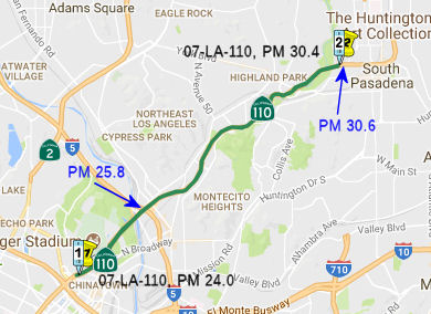
Figueroa Street - Orange Grove Dynamic Lanes (07-LA-110 PM 25.8/30.6)
In June 2017, the CTC approved the following SHOPP addition: 07-LA-110 25.8/30.6 Route 110: In the city of Los Angeles and South Pasadena, between Figueroa Street and Orange Grove Avenue. Convert outside lane to a dynamic lane/shoulder that can switch between the two depending on prevailing traffic conditions. This will require Dynamic Message Signs (DMS) monitored by the TMC. $4,982K (R/W) $25,284K (C) $13,278K (Support) PA&ED: 12/18/2018 R/W: 05/16/2020 RTL: 06/01/2020 BC: 02/26/2021. This project was included in the final adopted 2018 SHOPP in March 2018.
The 2020 SHOPP, approved in May 2020, included the
following Collision Reduction item of interest (carried over from the 2018
SHOPP): 07-LA-110 PM 25.8/30.6 PPNO 5083 Proj ID 0716000231 EA 33150.
Route 110 in the city of Los Angeles and South Pasadena, between Figueroa
Street and Orange Grove Avenue. Convert outside lane to a dynamic
lane/shoulder that can switch between the two depending on prevailing
traffic conditions. This will require Dynamic Message Signs (DMS)
monitored by the Transportation Management Center (TMC). Programmed in
FY20-21, with construction scheduled to start in January 2022. Total
project cost is $43,544K, with $30,266K being capital (const and right of
way) and $13,278K being support (engineering, environmental, etc.),
(Source: 2020 Approved SHOPP a/o May 2020)
According to Caltrans and the CTC, this safety
improvement project is located on Route 110 in the Cities of Los Angeles
and South Pasadena, in the County of Los Angeles. The freeway was built in
1940 with a design that predates current standards. The purpose of this
project is to address high accident rates attributed to the short
acceleration and deceleration lengths at the on-ramps and off-ramps. The
project will convert the existing outside lanes of the freeway into
shoulders, during off- peak hours, using Dynamic Message Signs that
respond to prevailing traffic conditions. When traffic volume is lower and
vehicle speeds are higher, the lanes will be converted to shoulders to
allow additional distance for acceleration, deceleration, and merging at
ramps. The shoulders will then convert back to lanes during peak hours
when vehicle speeds are lower.
(Source: January 2021 CTC Agenda, Agenda Item
2.5e.(2))
In January 2021, the CTC approved Caltrans' request for
an additional $1,071,000 in Capital Outlay Support (COS) for this project
(07-LA-110 25.8/30.6 PPNO 07-5083 ProjID 0716000231 EA 33150) to complete
the Project Approval and Environmental Document (PA&ED) project phase.
The PA&ED phase for this project was allocated in August 2017 for
$2,835,000. With the available G-12 authority, the total allotment for the
PA&ED phase is $3,319,000. A total of $2,973,000 has been expended to
date. Caltrans is requesting supplemental funds in the amount of
$1,071,000 to complete the remaining tasks for the PA&ED phase.
PA&ED is scheduled to occur in November 2021, and the ongoing work is
currently 50 percent complete. The requested funding is needed to issue
additional consultant task orders to supplement the efforts of Department
staff to meet the PA&ED schedule. The issuance of these task orders
has been placed on hold until the budget is available to cover the full
cost. As seen in the following action, Caltrans submitted a concurrent
request to deprogram all future phases of the project. These phases will
be re-programmed at the end of the environmental process after a preferred
alternative is selected and the associated costs are better known. Because
of the challenges described below, the development of this project has not
been consistent with that of other safety projects. To mitigate the length
of time to deliver permanent improvements, Caltrans has implemented
interim safety measures throughout this corridor, including upgrades to
barrier and lighting.
(Source: January 2021 CTC Agenda, Agenda Item
2.5e.(2))
The reason for the cost increase is interesting. This
project is located on the segment of Route 110 known as the Arroyo Seco
Parkway, which connects Pasadena with downtown Los Angeles. It is the
first freeway built in the western United States and is listed in the
National Register of Historic Places. An increase in the support cost is
being requested so that Caltrans can balance the goal of improving traffic
safety with the desire to preserve the historic elements of this facility.
At the beginning of the environmental process, Caltrans held public
scoping meetings to engage the community and identify its concerns. This
effort also included consultation with the State Historic Preservation
Officer (SHPO). Caltrans prepared and presented several design
alternatives that meet the need and purpose of this safety project. The
community expressed major concerns during these public scoping meetings,
especially regarding the visual impacts of the overhead Dynamic Message
Signs. To adequately address their concerns, a wider range of alternatives
are being considered. The Draft Environmental Document will contain six
alternatives, which is a larger number than was originally anticipated at
the time of programming. One alternative was introduced to permanently
convert outer lanes to shoulders and another alternative was expanded to
include further reconstruction work at ramps. With these two alternatives,
the use of the Dynamic Message Signs can be avoided. However, all six
alternatives are viable. A considerable amount of time and resources were
expended in refining the original alternatives. The use of consultant
contracts was an unplanned expense that was necessary to assist in the
preliminary engineering for this effort. A consultant contract is also
being used to supplement Caltrans staff in studying the environmental and
right of way impacts of the varied alternatives that came out of the
public scoping process, as some of the alternatives have a different
footprint than the scope of work that was originally programmed.
Significant effort will be needed to further address public concerns after
the Draft Environmental Document is released for public comments. Until a
preferred alternative is selected, Caltrans must study all viable
alternatives while attempting to expedite safety improvements. The
requested COS supplemental funds will allow the necessary resources to
complete these studies.
(Source: January 2021 CTC Agenda, Agenda Item
2.5e.(2))
As noted above, also in January 2021, the CTC amended
the 2020 SHOPP as follows regarding this project: (1b) #12. 07-LA-110
25.8/30.6 PPNO 5083 ProjID 0716000231 EA 33150. Route 110 In the city of
Los Angeles and South Pasadena, between Figueroa Street and Orange Grove
Avenue. Convert outside lane to a dynamic lane/shoulder that can switch
between the two depending on prevailing traffic conditions. This will
require Dynamic Message Signs (DMS) monitored by the Transportation
Management Center (TMC). The amendment unprogramed (i.e., zeroed out)
PS&E, R/W, and construction phases. Due to community input, additional
alternatives will be considered as part of the environmental process. The
remainder of the project will be re-programmed at completion of the
environmental document.
(Source: January 2021 CTC Agenda, Agenda Item
2.1a.(1b) #12)
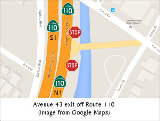 In January 2015, it was reported that residents who live
in areas adjacent to the Arroyo Seco Parkway and the offending abrupt
ramps have banded together to try and gather support for an idea
(previously introduced by Caltrans) that would reserve the right lanes on
both sides of the freeway just for drivers exiting or entering the
parkway. Jack Fenn of Montecito Heights and Clare Marter-Kenyon of Mount
Washington have collected 400 signatures on an online petition that begs for something to be done about the exit at Avenue 43 (~ LA 27.074); the 2012 Caltrans report their idea is based upon went further, suggesting the on/off-only lanes be adopted from Orange Grove (the northernmost point
of the freeway) down to Avenue 43. Parallel to this, a Caltrans rep
indicated that the agency is already looking into possibly having
exclusive on/off lanes at those entrances/exits during peak hours. In
September 2015, The Big Road Fix specifically explored how to correct the problems with the Avenue 43 exit of Route 110 near South Pasadena.
In January 2015, it was reported that residents who live
in areas adjacent to the Arroyo Seco Parkway and the offending abrupt
ramps have banded together to try and gather support for an idea
(previously introduced by Caltrans) that would reserve the right lanes on
both sides of the freeway just for drivers exiting or entering the
parkway. Jack Fenn of Montecito Heights and Clare Marter-Kenyon of Mount
Washington have collected 400 signatures on an online petition that begs for something to be done about the exit at Avenue 43 (~ LA 27.074); the 2012 Caltrans report their idea is based upon went further, suggesting the on/off-only lanes be adopted from Orange Grove (the northernmost point
of the freeway) down to Avenue 43. Parallel to this, a Caltrans rep
indicated that the agency is already looking into possibly having
exclusive on/off lanes at those entrances/exits during peak hours. In
September 2015, The Big Road Fix specifically explored how to correct the problems with the Avenue 43 exit of Route 110 near South Pasadena.
(Source: LAist, Curbed LA 1/14/2015)
Fair Oaks Avenue Interchange (~ LA 31.0)
The following project was included in the final adopted 2018 SHOPP in March 2018: PPNO 5196. 07-Los Angeles-110 31.0/31.0. On Route 110 In Pasadena and South Pasadena, at the Fair Oaks Avenue northbound offramp. Widen ramp from two lanes to four lanes. The city of South Pasadena will Advertise, Award, and Administer (AAA) the project construction contract. Begin Con: 4/20/2022. Total Project Cost: $3,773K.
In November 2018, it was reported that, as part of the mitigations from the cancellation of the Route 710 tunnel connection, improvements were planned for the Route 110/Fair Oaks interchange. LA Metro’s Ad Hoc Congestion, Highway and Roads Committee recommended the interchange be fixed as a first priority, awarding $38 million to South Pasadena to do so, part of the diversion of dollars once set aside in Measure R, a half-cent sales tax for transportation in the county, for the Route 710 Freeway north connector from I-10 to I-210. Without that roadblock removed, other fixes planned — traffic signal synchronization and removal of islands to add more right and left turn lanes — can proceed. In fact, South Pasadena also will get $10 million to synchronize traffic signals on Fair Oaks, Fremont and Huntington. Back in 1998, South Pasadena received $14.5 million from federal, state and local sources for street improvements, of which about $9.5 million remained. The city spent about $1 million on a reconfiguration plan for the Route 110 Freeway interchange at Fair Oaks that needs updating. It never got done because the city and Caltrans could never reach agreement. The project would include:
Once completed, South Pasadena and Pasadena can
synchronize traffic signals on Fair Oaks from Huntington Drive to I-210.
The cities could not do this until the signals, on- and off-ramps and turn
lanes are reconfigured at Route 110, as the freeway sits in the middle and
that is controlled by Caltrans.
(Source: Pasadena Star News, 11/26/2018)
In December 2019, the CTC had the following SHOPP
amendment on its agenda: 07-LA-110 31.0 PPNO 5196 Proj ID 0716000355 EA
33520. Route 110 In Pasadena and South Pasadena, at the Fair Oaks Avenue
northbound offramp. Widen ramp from two lanes to four lanes. The city of
South Pasadena will Advertise, Award, and Administer (AAA) the project
construction contract. Total Cost: $3,773K $1,401K.
Note: PS&E funds are not needed because Los Angeles County
Metropolitan Transportation Authority (LACMTA) will be doing the design
work.
(Source: December 2019 CTC Agenda, Agenda Item
2.1a.(1d) Item 38)
The 2020 SHOPP, approved in May 2020, included the
following Mobility item of interest (carried over from the 2018 SHOPP):
07-LA-110 PM 31.0/31.0 PPNO 5196 Proj ID 0716000355 EA 33520. Route 110 in
Pasadena and South Pasadena, at the Fair Oaks Avenue northbound offramp.
Widen ramp from two lanes to four lanes. The city of South Pasadena will
Advertise, Award, and Administer (AAA) the project construction contract.
Programmed in FY21-22, with construction scheduled to start in September
2022. Total planning contribution $1,400K.
(Source: 2020 Approved SHOPP a/o May 2020)
In March 2021, the CTC amended this project in the
SHOPP: (1d) #32. 07-LA-110 31.0/31.0 PPNO 5196 ProjID 0716000355 EA
33520. In Pasadena and South Pasadena, at the Fair Oaks
Avenue northbound offramp. Widen ramp from two lanes to four lanes. The
city of South Pasadena will Advertise, Award, and Administer (AAA) the
project construction contract. Amend to delete project. This
project was programmed to mitigate risk in the event that an adjacent
Route 710 project EA 02009/PPNO 07-0219M could not environmentally clear
this location. The Route 710 project completed PA&ED, so this project
is no longer needed.
(Source: March 2021 CTC Agenda, Agenda Item
2.1a.(1d) #32)
 Commuter Lanes
Commuter lanes exist on this route between Adams Boulevard in downtown Los Angeles and the Route 91 Freeway interchange. The portion between Slauson and 39th Street is an elevated HOV lane. They were opened to traffic in June 1993, require two or more occupants, and are in operation 24 hours a day. There has been talk of converting these into HOT lanes.
In June 2009, it was reported that Los Angeles County transportation officials were considering charging solo motorists 25 cents to $1.40 a mile to use the high occupancy toll lanes proposed for the Harbor and San Bernardino freeways. Officials plan to use congestion-based pricing, which means that tolls will rise and fall in direct relation with the flow of traffic — a formula designed to keep individual motorists, carpools, van pools and buses in the high occupancy lanes at a minimum of 45 mph, even during rush hour. Under the proposed pricing schedule, 25 cents a mile would be charged when demand is lowest for the lanes, while the maximum, $1.40 a mile, would be the toll during the busiest part of the day. Before the toll schedule is finalized in late July 2009, the public will be allowed to comment on the prices at five community hearings this month in Los Angeles, Torrance, Carson, El Monte and West Covina. The yearlong demonstration project has received $210.6 million in federal funds to help reduce traffic and improve bus service along the two freeways -- the largest congestion-easing grant awarded to any city to date, according to the U.S. Department of Transportation. Caltrans and the MTA will use the money to convert existing carpool lanes to high-occupancy toll lanes on 14 miles of the San Bernardino Freeway from Alameda Street to the 605 Freeway interchange and on 11 miles of the Harbor Freeway from Adams Boulevard to the Artesia Transit Center at 182nd Street. A second high-occupancy toll lane will be added in both directions to the San Bernardino Freeway. The project also calls for automated toll plazas, road improvements and additional transit services, including 57 clean-fuel buses for both freeway corridors. The entire project is expected to be completed by December 2010.
In March 2011, it was reported that the HOT lanes are expected to be complete in 2012. They will allow solitary drivers to enjoy the perks of car-pool lanes by paying a minimum of 25 cents per mile and a maximum $1.40 per mile. Tolls will be adjusted according to traffic conditions to maintain a free-flowing level of traffic. Buses, motorcycles, vanpools and carpools that currently use the car-pool lanes will not be charged a toll. General purpose lanes will continue to remain toll-free. Construction for the project, which is funded with a $210 million grant from the U.S. Department of Transportation, will begin in summer 2011.
In July 2011, ground was officially broken on the ExpressLanes project that will convert existing carpool (HOV) lanes along the Harbor Freeway (I-110) and the San Bernardino Freeway (I-10) to High-Occupancy Toll (HOT) lanes. The one-year demonstration program will covert 11 miles of existing carpool lanes on the I-110 (Harbor Freeway Transitway) between the Artesia Transit Center/182nd Street and Adams Boulevard near downtown Los Angeles and 14 miles on the I-10 (El Monte Busway) between Union Station/Alameda Street and the I-605 to toll lanes. During the construction phase of the program, workers will be installing a host of power and utility support units needed for the operation of 27 dynamic message signs (DMS) along the two freeway corridors as well as the installation of 22 toll transponder readers and approximately 145 signs to provide commuters information on the ExpressLanes and the tolls being charged to use the lanes. In addition, along the I-10 (San Bernardino Freeway) an additional toll lane will be constructed in each direction between the I-605 and the I-710 freeways to add capacity along that heavily traveled corridor. Currently, there is only one carpool lane operating in each direction along the El Monte Busway. None of the general purpose lanes will be taken away to covert the lanes and make the improvements. Construction crews also will widen Adams Boulevard off-ramp, add a right turn lane on Adams Boulevard, construct a pedestrian bridge, and re-stripe Figueroa Way in Los Angeles in support of the ExpressLanes project.
In June 2012, it was reported that drivers (even HOV drivers) will require a transponder for those routes. The so-called “congestion pricing” ranges between a minimum toll per mile of $0.25 and a maximum of $1.40 and will debut first in on I-110 in November, followed by I-10 early in 2013. Caltrans said the toll prices will fluctuate according to traffic levels in the carpool lane. Information on the project and the transponders can be found at the Metro ExpressLanes website.
In June 2014, LA Metro voted to make the HOT lanes permanent (they had previously been a demonstration project). The agency expected to distribute 100,000 of the transponders required to use the lanes, but ended up handing out more than 260,000.
 Naming
 The segment of Route 110 in San Pedro to US 101 (~LA 0.744 to LA 23.521) is named the "Harbor
Freeway". It was named by location. The first segment of the Harbor
Freeway opened in 1952; the last segment opened in 1970. This portion is
signed I-110. "Harbor" refers to San Pedro, which was originally named (in
October 1542, by Spanish explorer Juan Cabrillo) as "Bahia de los Fumos"
(Bay of Smokes). It was later named after Saint Peter, patron saint of
fishermen.
The segment of Route 110 in San Pedro to US 101 (~LA 0.744 to LA 23.521) is named the "Harbor
Freeway". It was named by location. The first segment of the Harbor
Freeway opened in 1952; the last segment opened in 1970. This portion is
signed I-110. "Harbor" refers to San Pedro, which was originally named (in
October 1542, by Spanish explorer Juan Cabrillo) as "Bahia de los Fumos"
(Bay of Smokes). It was later named after Saint Peter, patron saint of
fishermen.
(Image source: SoCal Regional Rocks and Roads; Aaron Robinson: In California, You Don't Have to Pay the Man—if You
Know the Code)
The portion of this route that was cosigned with US 6 (i.e., from
Route 1 in Long Beach to Route 5, ~ LA 4.115 to LA 25.624) was named the "Grand
Army of the Republic Highway" by Assembly Concurrent Resolution 33,
Chapter 73, in 1943. The GAR is a membership organization founded in
Decatur, Illinois on April 6, 1866 by Benjamin F. Stephenson. It's
membership was limited to honorably discharged veterans of the Union Army,
Navy, Marine Corps or the Revenue Cutter Service who had served between
April 12, 1861 and April 9, 1865. The GAR is responsible for the
establishment of Memorial Day, which began in 1868 when GAR
Commander-in-Chief John A. Logan issued General Order No. 11 calling for
all Departments and Posts to set aside the 30th of May as a day
for remembering the sacrifices of fallen comrades. The final Encampment of
the Grand Army of the Republic was held in Indianapolis, Indiana in 1949
and the last member, Albert Woolson died in 1956 at the age of 109 years.
[Information on the GAR excerpted from the pages of the Sons of Union Veterans of the Civil War].
 The Florence Avenue exit of Route 110 in the City of Los Angeles (~ LA 17.0) is
officially named the "Deputy Chief Kenneth O. Garner Memorial Exit".
This exit was named in memory of Kenneth O. Garner, who was born on
November 28, 1955, in Hot Springs, Arkansas, the third of four children
born to Otto and Mary Garner. Because his parents were both enlisted in
the United States Army during his childhood, he traveled the world and
lived in Taiwan, Germany, and Japan. Kenneth O. Garner graduated from San
Pedro High School in 1973 and received his Associate of Arts Degree in
Administration of Justice from Los Angeles Harbor College in 1975. He
received his Bachelor of Arts Degree in Psychology from the California
State University, Dominguez Hills in 1981. He was a graduate of the
Federal Bureau of Investigation (FBI) National Academy, and the
Supervisory Leadership Institute and the Senior Management Institute
Program (Boston University). Kenneth O. Garner was appointed to the Los
Angeles Police Department (LAPD) on June 6, 1977. As a police officer his
assignments included Southwest Area, 77th Street Area, Central
Area, 77th Street Vice, and Southeast Area. Upon promotion to
Sergeant in 1986, his assignments included Central Area, Operations-South
Bureau C.R.A.S.H., 77th Street Area, Internal Affairs Division,
and Operations-South Bureau, where he served as a Commander's Aide. After
being promoted to Lieutenant he was assigned to Wilshire Area and South
Traffic Division as a Watch Commander. In 1998, Lieutenant Garner was
promoted to the rank of Captain. His first assignment was in Foothill Area
as the Commanding Officer of the Operations-Support Division. He was also
assigned as the Commanding Officer of South Traffic Division, Foothill
Area, Transit Bus Division, and the 77th Street Area. On
October 2, 2005, Captain Garner was promoted to the rank of Commander and
assigned as the commanding officer of Personnel Group. In this assignment,
and among his many responsibilities, Commander Garner was responsible for
overseeing sworn, civilian, and reserve recruitment and hiring for the
department. He was charged with the enormous task of furthering the
mayor's hiring initiative to increase the LAPD's authorized strength to
10,000 sworn employees by 2010, the highest number of officers in LAPD
history. Due in large part to Commander Garner's efforts, the LAPD's
current sworn deployment is now at 9,895, a milestone achievement for the
department. This accomplishment is indicative that the department is on
pace to reach the mayor's goal of 10,000 officers later this year. On July
1, 2007, a month after celebrating his 30th year with the
department, Commander Garner was promoted to the rank of Deputy Chief of
Police. He was soon assigned as the Commanding Officer of Operations-West
Bureau, where he oversaw all police operations in the Hollywood, Wilshire,
West Los Angeles, and Pacific Areas and West Traffic Division. On March 2,
2008, Deputy Chief Garner returned to the community where he grew up and
assumed command of Operations-South Bureau, where he led the Criminal
Gang/Homicide Group, 77th Street, Southwest, Southeast, Harbor
Areas, and South Traffic Division. Deputy Chief Garner was a member in
good standing with the Oscar Joel Bryand Foundation and the Association of
Black Law Enforcement Executives, and was a member of the Epsilon Kappa
Chapter of the Kappa Alpha Psi Fraternity. He was also a member of the FBI
National Academy Association, the Northeast Toastmasters Club, and the Los
Angeles Police Command Officers Association. He was recipient of the
Trailblazer Award in 2008, where he was recognized for his outstanding
contribution to the progress of African Americans in the City of Los
Angeles. He received numerous community citations as well as awards from
the United States Congress, California State Assembly, and various church
and community organizations for his involvement and dedication to the
community. Deputy Chief Garner was a firm believer that teamwork played a
significant role in achieving success. He was truly determined to create
fundamental change for the people who live and work in the south region of
the City of Los Angeles. He supported residential, business, and community
organizations such as neighborhood Watch, the Watts Gang Task Force, and
the Los Angeles Urban League and Community Build. Deputy Chief Garner was
also committed to increasing the recognition and effectiveness of gang
intervention in the most troubled parts of the community. He also
initiated an innovative program for community re-entry and rehabilitation
of parolees, believing they deserved an opportunity for a better life.
Deputy Chief Garner enjoyed music, smooth jazz, and R&B, was an avid
reader, and a huge fan of the Los Angeles Dodgers and Lakers. He was also
a volunteer coach for youth basketball, baseball, and football at the Mar
Vista Recreation Center. Deputy Chief Garner passed away unexpectedly on
February 28, 2009, at the age of 53 years. Named by Senate Concurrent
Resolution (SCR) 106, Resolution Chapter 124, on 9/7/2010.
The Florence Avenue exit of Route 110 in the City of Los Angeles (~ LA 17.0) is
officially named the "Deputy Chief Kenneth O. Garner Memorial Exit".
This exit was named in memory of Kenneth O. Garner, who was born on
November 28, 1955, in Hot Springs, Arkansas, the third of four children
born to Otto and Mary Garner. Because his parents were both enlisted in
the United States Army during his childhood, he traveled the world and
lived in Taiwan, Germany, and Japan. Kenneth O. Garner graduated from San
Pedro High School in 1973 and received his Associate of Arts Degree in
Administration of Justice from Los Angeles Harbor College in 1975. He
received his Bachelor of Arts Degree in Psychology from the California
State University, Dominguez Hills in 1981. He was a graduate of the
Federal Bureau of Investigation (FBI) National Academy, and the
Supervisory Leadership Institute and the Senior Management Institute
Program (Boston University). Kenneth O. Garner was appointed to the Los
Angeles Police Department (LAPD) on June 6, 1977. As a police officer his
assignments included Southwest Area, 77th Street Area, Central
Area, 77th Street Vice, and Southeast Area. Upon promotion to
Sergeant in 1986, his assignments included Central Area, Operations-South
Bureau C.R.A.S.H., 77th Street Area, Internal Affairs Division,
and Operations-South Bureau, where he served as a Commander's Aide. After
being promoted to Lieutenant he was assigned to Wilshire Area and South
Traffic Division as a Watch Commander. In 1998, Lieutenant Garner was
promoted to the rank of Captain. His first assignment was in Foothill Area
as the Commanding Officer of the Operations-Support Division. He was also
assigned as the Commanding Officer of South Traffic Division, Foothill
Area, Transit Bus Division, and the 77th Street Area. On
October 2, 2005, Captain Garner was promoted to the rank of Commander and
assigned as the commanding officer of Personnel Group. In this assignment,
and among his many responsibilities, Commander Garner was responsible for
overseeing sworn, civilian, and reserve recruitment and hiring for the
department. He was charged with the enormous task of furthering the
mayor's hiring initiative to increase the LAPD's authorized strength to
10,000 sworn employees by 2010, the highest number of officers in LAPD
history. Due in large part to Commander Garner's efforts, the LAPD's
current sworn deployment is now at 9,895, a milestone achievement for the
department. This accomplishment is indicative that the department is on
pace to reach the mayor's goal of 10,000 officers later this year. On July
1, 2007, a month after celebrating his 30th year with the
department, Commander Garner was promoted to the rank of Deputy Chief of
Police. He was soon assigned as the Commanding Officer of Operations-West
Bureau, where he oversaw all police operations in the Hollywood, Wilshire,
West Los Angeles, and Pacific Areas and West Traffic Division. On March 2,
2008, Deputy Chief Garner returned to the community where he grew up and
assumed command of Operations-South Bureau, where he led the Criminal
Gang/Homicide Group, 77th Street, Southwest, Southeast, Harbor
Areas, and South Traffic Division. Deputy Chief Garner was a member in
good standing with the Oscar Joel Bryand Foundation and the Association of
Black Law Enforcement Executives, and was a member of the Epsilon Kappa
Chapter of the Kappa Alpha Psi Fraternity. He was also a member of the FBI
National Academy Association, the Northeast Toastmasters Club, and the Los
Angeles Police Command Officers Association. He was recipient of the
Trailblazer Award in 2008, where he was recognized for his outstanding
contribution to the progress of African Americans in the City of Los
Angeles. He received numerous community citations as well as awards from
the United States Congress, California State Assembly, and various church
and community organizations for his involvement and dedication to the
community. Deputy Chief Garner was a firm believer that teamwork played a
significant role in achieving success. He was truly determined to create
fundamental change for the people who live and work in the south region of
the City of Los Angeles. He supported residential, business, and community
organizations such as neighborhood Watch, the Watts Gang Task Force, and
the Los Angeles Urban League and Community Build. Deputy Chief Garner was
also committed to increasing the recognition and effectiveness of gang
intervention in the most troubled parts of the community. He also
initiated an innovative program for community re-entry and rehabilitation
of parolees, believing they deserved an opportunity for a better life.
Deputy Chief Garner enjoyed music, smooth jazz, and R&B, was an avid
reader, and a huge fan of the Los Angeles Dodgers and Lakers. He was also
a volunteer coach for youth basketball, baseball, and football at the Mar
Vista Recreation Center. Deputy Chief Garner passed away unexpectedly on
February 28, 2009, at the age of 53 years. Named by Senate Concurrent
Resolution (SCR) 106, Resolution Chapter 124, on 9/7/2010.
(Image source: YouTube; LAPD)
 The roadway was called the Arroyo Seco Parkway when its first six-mile section between Pasadena and Avenue 22 opened in 1940. At
some point, it morphed into the "Arroyo Seco Freeway"—a name
that lasted until 1954. The name came back per Caltrans statute in 1993,
when the segment was renamed the "Arroyo Seco Parkway".
[specifically, AB 1247 (Polanco) established a system of California
Historical Parkways to include highways built before 1945, and designated
asegment of the Pasadena Freeway as a California Historical Parkway and
names it the "Arroyo Seco Parkway". Chaptered as Chapter 179,
Statutes of 1993] The Parkway has been designated (by the ASCE) as a
historic engineering landmark and qualifies for inclusion in the National
Register of Historic Places. There is HAER documentation on it, some of
which is available on Caltrans' website. However, neither the Parkway nor
the Four Level have been included on the National Register of Historic
Places or been designated National Historic Landmarks. In 2010, the Los
Angeles Times reported that the Arroyo Seco Parkway name has
replaced the Pasadena Freeway name. The new "Parkway" signs are being
erected along I-5 between Route 2 and 1st Street; along US 101
from Alvarado Street to Soto Street; and on Route 110 between Wilshire
Boulevard and Pasadena (~ LA 22.669 to LA 30.6). The signs will cost about
$650,000 and should be installed by Fall 2010; the other improvements will
cost $17 million and should be finished by Spring 2011. In October 2010,
the LA City Cultural Heritage Commission reviewed a staff recommendation
to support having the West’s oldest freeway listed on the National
Register of Historic Places. The Highland Park Heritage Trust said it
supports the nomination. The effort to designate the freeway a national
historic monument comes only months after Caltrans angered the Highland
Park Heritage Trust and other preservationists by demolishing sections of
the freeway median and other features for a safety improvement project. In
the end, the motion was supported with modifications.
The roadway was called the Arroyo Seco Parkway when its first six-mile section between Pasadena and Avenue 22 opened in 1940. At
some point, it morphed into the "Arroyo Seco Freeway"—a name
that lasted until 1954. The name came back per Caltrans statute in 1993,
when the segment was renamed the "Arroyo Seco Parkway".
[specifically, AB 1247 (Polanco) established a system of California
Historical Parkways to include highways built before 1945, and designated
asegment of the Pasadena Freeway as a California Historical Parkway and
names it the "Arroyo Seco Parkway". Chaptered as Chapter 179,
Statutes of 1993] The Parkway has been designated (by the ASCE) as a
historic engineering landmark and qualifies for inclusion in the National
Register of Historic Places. There is HAER documentation on it, some of
which is available on Caltrans' website. However, neither the Parkway nor
the Four Level have been included on the National Register of Historic
Places or been designated National Historic Landmarks. In 2010, the Los
Angeles Times reported that the Arroyo Seco Parkway name has
replaced the Pasadena Freeway name. The new "Parkway" signs are being
erected along I-5 between Route 2 and 1st Street; along US 101
from Alvarado Street to Soto Street; and on Route 110 between Wilshire
Boulevard and Pasadena (~ LA 22.669 to LA 30.6). The signs will cost about
$650,000 and should be installed by Fall 2010; the other improvements will
cost $17 million and should be finished by Spring 2011. In October 2010,
the LA City Cultural Heritage Commission reviewed a staff recommendation
to support having the West’s oldest freeway listed on the National
Register of Historic Places. The Highland Park Heritage Trust said it
supports the nomination. The effort to designate the freeway a national
historic monument comes only months after Caltrans angered the Highland
Park Heritage Trust and other preservationists by demolishing sections of
the freeway median and other features for a safety improvement project. In
the end, the motion was supported with modifications.
(Image source: Wikipedia; NBC Los Angeles; Facebook)
 The segment N of the four-level interchange with US-101 (signed as State Route 110) (~ LA 23.521 to LA 30.6) was named
the "Pasadena Freeway" until 2010. It was named by the State
Highway Commission on November 18, 1954. Pasadena refers to the route's
terminus in the city of Pasadena, which was adopted by the stockholders of
the Indiana Colony in 1875, and was taken from the language of the
Chippewa Indians of the Mississippi Valley and means "valley."
The segment N of the four-level interchange with US-101 (signed as State Route 110) (~ LA 23.521 to LA 30.6) was named
the "Pasadena Freeway" until 2010. It was named by the State
Highway Commission on November 18, 1954. Pasadena refers to the route's
terminus in the city of Pasadena, which was adopted by the stockholders of
the Indiana Colony in 1875, and was taken from the language of the
Chippewa Indians of the Mississippi Valley and means "valley."
(Image source: 404'd page on Flikr)
 Named Structures
 The interchange of I-405
and I-110 (~ LA 8.629 to LA 8.97) in the City of Carson in the County of
Los Angeles is named the "CHP Officer Merle L. Andrews Memorial
Interchange". This interchange was named in memory of CHP Officer
Merle L. Andrews, who was killed in the line of duty on December 20, 1967.
Officer Andrews was attempting to arrest a man wanted in connection with a
stolen vehicle, robbery, and kidnaping when the man opened fire on Officer
Andrews, and Officer Andrews succumbed to his injuries as a result of the
shooting. Officer Andrews was born on February 4, 1928, in Redondo Beach,
California; his family settled in Compton where he graduated from Compton
High School and attended Compton Junior College. He enlisted in the United
States Navy serving from 1945 through 1949, and also followed in the
footsteps of his father and brother by joining the Compton Police
Department. He joined the CHP on July 8, 1958. After successfully
completing his academy training, he reported to the South Los Angeles area
on October 3, 1958. During his CHP career, Merle L. Andrews made
significant contributions to traffic safety and assisting the motoring
public and was known by his fellow officers for his dedication to the
department and to the protection of the citizens of our state. Named by
Assembly Concurrent Resolution (ACR) 20, Resolution Chapter 65, on
07/07/2005.
The interchange of I-405
and I-110 (~ LA 8.629 to LA 8.97) in the City of Carson in the County of
Los Angeles is named the "CHP Officer Merle L. Andrews Memorial
Interchange". This interchange was named in memory of CHP Officer
Merle L. Andrews, who was killed in the line of duty on December 20, 1967.
Officer Andrews was attempting to arrest a man wanted in connection with a
stolen vehicle, robbery, and kidnaping when the man opened fire on Officer
Andrews, and Officer Andrews succumbed to his injuries as a result of the
shooting. Officer Andrews was born on February 4, 1928, in Redondo Beach,
California; his family settled in Compton where he graduated from Compton
High School and attended Compton Junior College. He enlisted in the United
States Navy serving from 1945 through 1949, and also followed in the
footsteps of his father and brother by joining the Compton Police
Department. He joined the CHP on July 8, 1958. After successfully
completing his academy training, he reported to the South Los Angeles area
on October 3, 1958. During his CHP career, Merle L. Andrews made
significant contributions to traffic safety and assisting the motoring
public and was known by his fellow officers for his dedication to the
department and to the protection of the citizens of our state. Named by
Assembly Concurrent Resolution (ACR) 20, Resolution Chapter 65, on
07/07/2005.
(Image source: California Assn of Highway Patrolmen)
 Bridge 53-958 on I-110, the I-110/Route 91 interchange
(~ LA 9.626 to LA 10.06), is named the "Edmond J. Russ Interchange".
It was built in 1985, and was named by Assembly Concurrent Resolution 135,
Chapter 162. Ed Russ is a former mayor of Gardena; during his term (which
ended in 1982) he was able to push for the extension of the then Redondo
Beach Freeway to the Route 110. This extension relieved the traffic that
plagued Artesia Blvd from the end of the freeway at Broadway to Route 110.
When the extension was completed in 1985, it was given the legislative
name in his honor, but it was up to the private sector to produce the
funds to make and install the signs for the interchange. It wasn't until
1998-99 that a group of Gardena businesspeole and citizens, led by the
Gardena Valley News, began a campaign to raise the money needed. The signs
were installed in the latter half of 1999.
Bridge 53-958 on I-110, the I-110/Route 91 interchange
(~ LA 9.626 to LA 10.06), is named the "Edmond J. Russ Interchange".
It was built in 1985, and was named by Assembly Concurrent Resolution 135,
Chapter 162. Ed Russ is a former mayor of Gardena; during his term (which
ended in 1982) he was able to push for the extension of the then Redondo
Beach Freeway to the Route 110. This extension relieved the traffic that
plagued Artesia Blvd from the end of the freeway at Broadway to Route 110.
When the extension was completed in 1985, it was given the legislative
name in his honor, but it was up to the private sector to produce the
funds to make and install the signs for the interchange. It wasn't until
1998-99 that a group of Gardena businesspeole and citizens, led by the
Gardena Valley News, began a campaign to raise the money needed. The signs
were installed in the latter half of 1999.
(Image source: Freeway City)
 The I-110/I-105 interchange (~ LA
13.463 to LA 14.263) is named the "Judge Harry Pregerson Interchange".
It was named in honor of Judge Harry Pregerson, who was born in Los
Angeles, California in 1923. Judge Pregerson received his Bachelor of Arts
from the University of California, Los Angeles in 1947, and was awarded a
Bachelor of Laws from the University of California, Berkeley, Boalt Hall
School of Law in 1950. He served his country as a United States Marine
Corps First Lieutenant from 1944 to 1946 and was severely wounded in the
battle of Okinawa in World War II. Pregerson was an attorney in private
practice from 1951 to 1965, was a judge of the Los Angeles Municipal Court
from 1965 to 1966, was a judge of the Los Angeles Superior Court from 1966
to 1967, was appointed to the United States District Court for the Central
District of California on December 7, 1967, and was appointed to the
United States Court of Appeals for the Ninth Circuit on November 2, 1979.
Judge Pregerson presided over the Century Freeway lawsuit for more than
two decades starting in 1972, and kept control of the case for more than a
dozen years after he was elevated to the appeals court even though he
could have surrendered it to another judge. Additionally, Judge Harry
Pregerson ensured the construction of nearly 5,000 affordable housing
units to replace homes removed to make way for the Century Freeway and
oversaw the housing program under a consent decree from 1972 to 1995.
Pregerson insisted that a major portion of the construction jobs involved
in the building go to minorities and women and, when there were not enough
minorities and women qualified for the jobs, he helped to create a
construction apprenticeship program for them. The Century Freeway Housing
Program, now known as the Century Housing Corporation, a nonprofit
organization, grew out of the settlement of the Century Freeway lawsuit
presided over by Judge Harry Pregerson, and provided funds to acquire the
Westwide Residence Hall which houses 500 formerly homeless veterans and is
the largest housing and employment center for homeless veterans in the
country. The settlement of the Century Freeway lawsuit permitted
construction of I-105, known as the Century Freeway. In 1988 Judge Harry
Pregerson founded the Bell Homeless Shelter, of which one-third of the
clients are veterans, at a federal supply center in southeast Los Angeles
County. The next year, Pregerson partnered with charities, veterans
groups, labor organizations, the federal General Services Administration,
and then Los Angeles Mayor Tom Bradley to start the Westwood Transitional
Village, which provided furnished apartments for homeless families, with
preference given to veterans. Five years later, in 1994, Judge Pregerson
helped start the Salvation Army’s Haven Program, which arranges
housing and provides support services for homeless veterans. Additionally,
Judge Pregerson helped bring together judges, law enforcement, and county
officials to create a “homeless court,” which can clear an
offender’s record of minor violations, providing an incentive for
homeless individuals to complete a rehabilitation program and return to a
productive life. Until December 2015, Judge Harry Pregerson was the oldest
active judge on the Ninth Circuit Court of Appeals. He retired 12/27/2015 at the age of 92. The article on his retirement included the following quote: "I can't think of anything more important than to try
to help as many people as you can. That is a big motivator for me.
Sometimes the law is not very compassionate." Named by Assembly Concurrent
Resolution 142, Resolution Chapter 43, May 3, 2002.
The I-110/I-105 interchange (~ LA
13.463 to LA 14.263) is named the "Judge Harry Pregerson Interchange".
It was named in honor of Judge Harry Pregerson, who was born in Los
Angeles, California in 1923. Judge Pregerson received his Bachelor of Arts
from the University of California, Los Angeles in 1947, and was awarded a
Bachelor of Laws from the University of California, Berkeley, Boalt Hall
School of Law in 1950. He served his country as a United States Marine
Corps First Lieutenant from 1944 to 1946 and was severely wounded in the
battle of Okinawa in World War II. Pregerson was an attorney in private
practice from 1951 to 1965, was a judge of the Los Angeles Municipal Court
from 1965 to 1966, was a judge of the Los Angeles Superior Court from 1966
to 1967, was appointed to the United States District Court for the Central
District of California on December 7, 1967, and was appointed to the
United States Court of Appeals for the Ninth Circuit on November 2, 1979.
Judge Pregerson presided over the Century Freeway lawsuit for more than
two decades starting in 1972, and kept control of the case for more than a
dozen years after he was elevated to the appeals court even though he
could have surrendered it to another judge. Additionally, Judge Harry
Pregerson ensured the construction of nearly 5,000 affordable housing
units to replace homes removed to make way for the Century Freeway and
oversaw the housing program under a consent decree from 1972 to 1995.
Pregerson insisted that a major portion of the construction jobs involved
in the building go to minorities and women and, when there were not enough
minorities and women qualified for the jobs, he helped to create a
construction apprenticeship program for them. The Century Freeway Housing
Program, now known as the Century Housing Corporation, a nonprofit
organization, grew out of the settlement of the Century Freeway lawsuit
presided over by Judge Harry Pregerson, and provided funds to acquire the
Westwide Residence Hall which houses 500 formerly homeless veterans and is
the largest housing and employment center for homeless veterans in the
country. The settlement of the Century Freeway lawsuit permitted
construction of I-105, known as the Century Freeway. In 1988 Judge Harry
Pregerson founded the Bell Homeless Shelter, of which one-third of the
clients are veterans, at a federal supply center in southeast Los Angeles
County. The next year, Pregerson partnered with charities, veterans
groups, labor organizations, the federal General Services Administration,
and then Los Angeles Mayor Tom Bradley to start the Westwood Transitional
Village, which provided furnished apartments for homeless families, with
preference given to veterans. Five years later, in 1994, Judge Pregerson
helped start the Salvation Army’s Haven Program, which arranges
housing and provides support services for homeless veterans. Additionally,
Judge Pregerson helped bring together judges, law enforcement, and county
officials to create a “homeless court,” which can clear an
offender’s record of minor violations, providing an incentive for
homeless individuals to complete a rehabilitation program and return to a
productive life. Until December 2015, Judge Harry Pregerson was the oldest
active judge on the Ninth Circuit Court of Appeals. He retired 12/27/2015 at the age of 92. The article on his retirement included the following quote: "I can't think of anything more important than to try
to help as many people as you can. That is a big motivator for me.
Sometimes the law is not very compassionate." Named by Assembly Concurrent
Resolution 142, Resolution Chapter 43, May 3, 2002.
(Image Source: BerkeleyLaw, 11/30/2017)
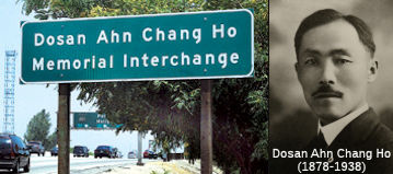 The I-10/I-110 interchange (~ LA 21.202 to LA 21.656) is
officially named the "Dosan Ahn Chang Ho Memorial Interchange".
Dosan Ahn Chang Ho was born in a small village in Korea in 1878. He
arrived in America in 1902 with his newlywed wife, Lee Hae Ryon (Helen
Ahn). As the steamship approached Hawaii, Ahn Chang Ho resolved to stand
tall above the sea of turmoil existing at that time in Korea, and resolved
to call himself "Dosan," which means Island Mountain. While living in San
Francisco, Dosan organized the San Francisco Social Meeting on September
23, 1903, and initiated a social reform movement that was in desperate
need in the Korean American society. As an accomplished orator and leader
at the age of 24, Dosan guided his countrymen to form a respectable
community for Koreans in the United States. He and his family settled in
Riverside, California, in March 1904 and worked tirelessly to unite Korean
Americans and to revive the patriotic spirit of the Korean people. He
moved to Los Angeles in 1913, where the Dorothy Chandler Pavilion now
stands, and played a significant role in the growth of the Korean American
community in the City of Los Angeles. Together with his friends, he formed
the Gonglip-Hyuphoe, or Cooperative Association, which would become the
basis for the Korean National Association, which Dosan later led as
president. This association maintained structure within the Korean
American community, both to build character of individuals and to enhance
the image of Koreans within the mainstream community. Dosan also
established one of the first English schools for Koreans so that his
fellow Korean Americans could learn English and the Bible. He helped to
relieve blighted living conditions for his fellow Korean Americans in the
Greater Los Angeles area, and became the spiritual leader of the Korean
Independence Movement. Following Japan's annexation of Korea in 1910,
Dosan formulated the basis for the Provisional Government of Korea, and
conceived Hung Sa Dahn (Young Korean Academy), an organization to develop
leaders for the independence movement, in 1913. In 1915, Dosan promoted
the development of the Korean language program for second generation
Korean Americans as an opportunity to pass on Korean traditions, values,
and identity to younger generations. Through his work, Dosan Ahn Chang Ho
had an enormously beneficial impact and significance on the history of
modern Korea and Korean Americans. Dosan's philosophy and teachings serve
as a model for Korean American youths. The interchange was named in honor
of the 100th Year Centennial Immigration for Korean Americans
to the United States. Named by Senate Concurrent Resolution 104, Chapter
160, September 11, 2002.
The I-10/I-110 interchange (~ LA 21.202 to LA 21.656) is
officially named the "Dosan Ahn Chang Ho Memorial Interchange".
Dosan Ahn Chang Ho was born in a small village in Korea in 1878. He
arrived in America in 1902 with his newlywed wife, Lee Hae Ryon (Helen
Ahn). As the steamship approached Hawaii, Ahn Chang Ho resolved to stand
tall above the sea of turmoil existing at that time in Korea, and resolved
to call himself "Dosan," which means Island Mountain. While living in San
Francisco, Dosan organized the San Francisco Social Meeting on September
23, 1903, and initiated a social reform movement that was in desperate
need in the Korean American society. As an accomplished orator and leader
at the age of 24, Dosan guided his countrymen to form a respectable
community for Koreans in the United States. He and his family settled in
Riverside, California, in March 1904 and worked tirelessly to unite Korean
Americans and to revive the patriotic spirit of the Korean people. He
moved to Los Angeles in 1913, where the Dorothy Chandler Pavilion now
stands, and played a significant role in the growth of the Korean American
community in the City of Los Angeles. Together with his friends, he formed
the Gonglip-Hyuphoe, or Cooperative Association, which would become the
basis for the Korean National Association, which Dosan later led as
president. This association maintained structure within the Korean
American community, both to build character of individuals and to enhance
the image of Koreans within the mainstream community. Dosan also
established one of the first English schools for Koreans so that his
fellow Korean Americans could learn English and the Bible. He helped to
relieve blighted living conditions for his fellow Korean Americans in the
Greater Los Angeles area, and became the spiritual leader of the Korean
Independence Movement. Following Japan's annexation of Korea in 1910,
Dosan formulated the basis for the Provisional Government of Korea, and
conceived Hung Sa Dahn (Young Korean Academy), an organization to develop
leaders for the independence movement, in 1913. In 1915, Dosan promoted
the development of the Korean language program for second generation
Korean Americans as an opportunity to pass on Korean traditions, values,
and identity to younger generations. Through his work, Dosan Ahn Chang Ho
had an enormously beneficial impact and significance on the history of
modern Korea and Korean Americans. Dosan's philosophy and teachings serve
as a model for Korean American youths. The interchange was named in honor
of the 100th Year Centennial Immigration for Korean Americans
to the United States. Named by Senate Concurrent Resolution 104, Chapter
160, September 11, 2002.
(Image source: Dosan Ahn Chang Ho Official Site)
Colloquially, the intersection of US 101 and Route 110 (~ LA 23.6 to LA 23.982) is called the "Four Level Interchange". Plans for it were unveiled in 1947 and it was constructed and open to traffic by 1949 or 1953-54, depending on who you believe. (SCAQMD and Library of Congress say 1949; Caltrans' own website says 1953; a historian at USC has material on the Web that says 1954). According to the Automobile Club, by the early 1950s the uppermost roadway was open for traffic on the Hollywood Freeway. The connections to the Harbor/Pasadena Freeway were completed a year later. This was the world's first four-level interchange. The Four Level itself has been recognized as a historic resource in its own right for some time. This has resulted in ill-advised cosmetic modifications, such as a cast-concrete bridge rail installed because it was considered to look "historic" (in fact the Four Level opened with very modern-looking steel bridge rails), as shown in the famous 1954 photo Caltrans Public Affairs has put online.
 The Four Level Interchange (~ LA 23.6 to LA 23.982) is officially named the Bill Keene Interchange. It was
named in honor of Bill Keene, a traffic and weather reporter for KNX Radio
in Los Angeles from 1957 until his retirement in 1993. Mr. Keene served in
a similar capacity on KNXT/Channel 2 and was part of the highly successful
"The Big News" with Jerry Dunphy and sports announcer Gil Stratton. Mr.
Keene was born on July 1, 1927, and started his professional career in
Scottsbluff, Nebraska, winning an audition at his high school, and served
in the United States Air Force in World War II as a pilot. Mr. Keene
became interested in weather reporting as a career after an unruly winter
interrupted his private flying lessons. Mr. Keene worked at KBOL-Boulder
and later hosted the Bill Keene Show" in Los Angeles, which was a local
variety show, where he met his future wife Louise Vienna. In his traffic
and weather-reporting days, Mr. Keene made traffic reports more
interesting by referring to accidents with words like "cattywampus,"
"chrome cruncher," and "paint peeler". Named by Senate Concurrent
Resolution 78, Chapter 165, August 30, 2004.
The Four Level Interchange (~ LA 23.6 to LA 23.982) is officially named the Bill Keene Interchange. It was
named in honor of Bill Keene, a traffic and weather reporter for KNX Radio
in Los Angeles from 1957 until his retirement in 1993. Mr. Keene served in
a similar capacity on KNXT/Channel 2 and was part of the highly successful
"The Big News" with Jerry Dunphy and sports announcer Gil Stratton. Mr.
Keene was born on July 1, 1927, and started his professional career in
Scottsbluff, Nebraska, winning an audition at his high school, and served
in the United States Air Force in World War II as a pilot. Mr. Keene
became interested in weather reporting as a career after an unruly winter
interrupted his private flying lessons. Mr. Keene worked at KBOL-Boulder
and later hosted the Bill Keene Show" in Los Angeles, which was a local
variety show, where he met his future wife Louise Vienna. In his traffic
and weather-reporting days, Mr. Keene made traffic reports more
interesting by referring to accidents with words like "cattywampus,"
"chrome cruncher," and "paint peeler". Named by Senate Concurrent
Resolution 78, Chapter 165, August 30, 2004.
(Image source: Franklin Ave Blog; Wikipedia; The Southern Californian)
 Tunnel 53-201R, at Figueroa Street (~ LA 24.909) in Los Angeles in Los Angeles county, is named the "Figueroa
Street Tunnels". They were built in 1936.
Tunnel 53-201R, at Figueroa Street (~ LA 24.909) in Los Angeles in Los Angeles county, is named the "Figueroa
Street Tunnels". They were built in 1936.
(Image source: SoCal Regional Rocks and Roads)
 Historical Route
[SHC 283] Between LA 25.7 and LA 31.9 is designated the "Arroyo Seco Parkway". This allows for reduced speed, and stimulated efforts to pursue preservation and rehabilitation of the historic roadway. There is a plan to turn this section into a Scenic Byway.
The portion of this route between Route 210 and Route 101 (i.e., ~ LA 23.521 to LA 30.6), as well as the parallel surface routings along Fair Oaks and Figueroa, are part of "Historic Highway Route 66", designated by Assembly Concurrent Resolution 6, Chapter 52, in 1991.
ACR 26 requested the Department of Transportation, upon application by an interested local agency or private entity, to identify any section of former U.S. Highway Route 6 that is still a publicly maintained highway and that is of interest to the applicant, and to designate that section as Historic U.S. Highway Route 6. Chaptered July 3, 2007. Resolution Chapter 67.
 National Trails
 This portion of this route from Route 210 to Route 101
(i.e., the segment that was US 66) was part of the "Arrowhead Trail
(Ocean to Ocean Trail)". It was named by Resolution Chapter 369 in
1925.
This portion of this route from Route 210 to Route 101
(i.e., the segment that was US 66) was part of the "Arrowhead Trail
(Ocean to Ocean Trail)". It was named by Resolution Chapter 369 in
1925.
 This portion of this route from Route 210 to Route 101 (i.e.,
the segment that was US 66) was part of the "National Old Trails Road".
This portion of this route from Route 210 to Route 101 (i.e.,
the segment that was US 66) was part of the "National Old Trails Road".
 This portion of this route from Route 210 to Route 101
(i.e., the segment that was US 66) was part of the "New Santa Fe Trail".
This portion of this route from Route 210 to Route 101
(i.e., the segment that was US 66) was part of the "New Santa Fe Trail".

 This portion of this route from Route 210 to
Route 101 (i.e., the segment that was US 66) appears to have been part of
the "National Park to Park Highway", and the "Pikes Peak Ocean
to Ocean Highway".
This portion of this route from Route 210 to
Route 101 (i.e., the segment that was US 66) appears to have been part of
the "National Park to Park Highway", and the "Pikes Peak Ocean
to Ocean Highway".
 The portion of this route from I-5 (former US 99) to Route 1
(i.e., former US 6) was part of the "Midland Trail".
The portion of this route from I-5 (former US 99) to Route 1
(i.e., former US 6) was part of the "Midland Trail".
 Interstate Submissions
 The portion from Route 47 in San Pedro to Route 10 was approved as chargeable interstate in December 1978.
The portion from I-10 to I-210 was submitted for inclusion in the
system in 1945, but it was not accepted. Only the portion from Route 47 to
Route 10 is signed as Interstate. However, it appears that the SB section
of Route 110 between US 101 and I-10 may be signed as I-110. See notes on
Route 101 for past use of the Route number.
In April 1958, the designation I-110 was proposed for the Embarcadero Freeway, as part of the first attempts to number urban routes (in that proposal, what was later I-110 in downtown was proposed as part of I-106). The Embarcadero was later proposed as I-380, which was later approved as I-480, downgraded to Route 480, and ultimately relinquished and destroyed.
At the time the Embarcadero was proposed as I-380, the stub connector between the current I-10/I-5 junction and the current I-10/US 101 junction was proposed as I-110 (with I-10 actually being cosigned with I-5 between the nothern segment of I-10 (San Bernardino Fwy) and the southern segment of I-10 (Santa Monica Freeway). This was the designation until 1968, when that I-110 stub was numbered as part of I-10, and the section of US 101 between the US 101/I-10 junction and the I-10/I-5/US 101 junction was renumbered from I-105 to US 101.
 Exit Information
 Other WWW Links
 Classified Landcaped Freeway
The following segments are designated as Classified Landscaped Freeway:
| County | Route | Starting PM | Ending PM |
| Los Angeles | 110 | 0.76 | 1.25 |
| Los Angeles | 110 | 1.35 | 11.24 |
| Los Angeles | 110 | 11.52 | 11.95 |
| Los Angeles | 110 | 12.13 | 17.98 |
| Los Angeles | 110 | 18.03 | 19.49 |
| Los Angeles | 110 | 20.03 | 20.34 |
| Los Angeles | 110 | 20.59 | 25.47 |
| Los Angeles | 110 | 25.64 | 26.62 |
| Los Angeles | 110 | 29.95 | 31.69 |
 Freeway
[SHC 253.5] From Route 47 to Colorado Boulevard in Pasadena. Added to the Freeway and Expressway system in 1959.
 Statistics
Overall statistics for Route 110:
 Pre-1964 Legislative Route
In 1933, Chapter 767 defined the route from "Fresno-Tracy West Side Highway to the Sonora-Mariposa Road via Modesto" as a state highway. In 1935, LRN 110 was codified into the highway system as:
In 1957, Chapter 36 changed the orign from LRN 41 to "[LRN 5] near Tracy"
In 1959, Chapter 1062 changed the origin to "[LRN 75] near Brentwood", and explicitly added a connection to "[LRN 238] southwest of Vernanlis". This added the little section along present I-580 between Route 132 and I-5.
This route ran from Route 4 near Brentwood to Route 49 via Modesto, and included a connection to I-5 SW of Vernalis.
The segment between Route 49 and I-580 was Route 132. The segment between I-5 and I-580 at the San Joaquin/Alameda county line was I-580.
The remainder of the route ran from the I-580/I-205 split to Route 4 near Brentwood, and was unconstructed Route 239.
© 1996-2020 Daniel P. Faigin.
Maintained by: Daniel P. Faigin
<webmaster@cahighways.org>.
 Route 109
 Route 111