
 California Highways:
Click here for a key to the symbols used. An explanation of acronyms may be found at the bottom of the page.
 Routing
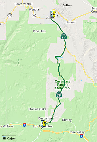 From Route 8 near Descanso to Route 78 near Julian.
 Post 1964 Signage History
As defined in 1963, this segment ran from (a) Route 8 near Descanso to Route 78.
In 1981, Chapter 292 changed the terminus of this segment to be "Route 78 near Julian".
 Pre 1964 Signage History
  In 1934, Route 79 was signed along the route from Jct. US 80
near Descanso to Temecula via Aguanga. This segment was LRN 78, defined in
1933.
In 1934, Route 79 was signed along the route from Jct. US 80
near Descanso to Temecula via Aguanga. This segment was LRN 78, defined in
1933.
 Naming
 The portion of Rout 79 from the intersection with Engineers Road in Cuyamaca to the intersection with Route 78 in Julian (~ 79 SD 12.139 to 79 SD 20.198),
then along Route 78 to the intersection with the next segment of Route 79
in Santa Ysabel to in San Diego County (~ 78 SD 51.126 to 78 SD 58.11) is
named the Firefighter Steven Rucker Memorial Highway. It was named
in memory of Firefighter Steven Rucker of Novato, California. In late
October 2003, Southern California experienced several devastating
wildfires that exceeded the devastation of any fires in the past century.
In San Diego County alone 400,000 acres burned, 2,600 homes where
destroyed, and 17 lives were lost. Dedicated firefighters from across
California and nationwide responded to the urgent call for assistance and
put their lives and personal safety at risk to save the lives and property
of the residents of San Diego County. Additionally, members of the Armed
Forces courageously met their country's call to duty, providing valuable
firefighting assets and assistance to California's emergency response
efforts in keeping with the finest traditions of United States military
service. Firefighters displayed courage and uncommon bravery in working
the fire lines for long hours and with little rest, often while their own
homes and families were in jeopardy elsewhere, and many of these
firefighters lost their own homes to the fires while defending the lives
and property of others. Through the tireless and heroic efforts of
California's firefighters, volunteers, and members of the community, the
historic town of Julian was ultimately saved from destruction by the
wildfires. One of these firefighters, Steven Rucker of Novato, California
gave the ultimate sacrifice and lost his life in San Diego County on
October 29th, 2003 fighting the advancing fire line as it threatened the
town of Julian and neighboring mountain communities. Named by Senate
Concurrent Resolution 53, July 8, 2004, Chapter 114.
The portion of Rout 79 from the intersection with Engineers Road in Cuyamaca to the intersection with Route 78 in Julian (~ 79 SD 12.139 to 79 SD 20.198),
then along Route 78 to the intersection with the next segment of Route 79
in Santa Ysabel to in San Diego County (~ 78 SD 51.126 to 78 SD 58.11) is
named the Firefighter Steven Rucker Memorial Highway. It was named
in memory of Firefighter Steven Rucker of Novato, California. In late
October 2003, Southern California experienced several devastating
wildfires that exceeded the devastation of any fires in the past century.
In San Diego County alone 400,000 acres burned, 2,600 homes where
destroyed, and 17 lives were lost. Dedicated firefighters from across
California and nationwide responded to the urgent call for assistance and
put their lives and personal safety at risk to save the lives and property
of the residents of San Diego County. Additionally, members of the Armed
Forces courageously met their country's call to duty, providing valuable
firefighting assets and assistance to California's emergency response
efforts in keeping with the finest traditions of United States military
service. Firefighters displayed courage and uncommon bravery in working
the fire lines for long hours and with little rest, often while their own
homes and families were in jeopardy elsewhere, and many of these
firefighters lost their own homes to the fires while defending the lives
and property of others. Through the tireless and heroic efforts of
California's firefighters, volunteers, and members of the community, the
historic town of Julian was ultimately saved from destruction by the
wildfires. One of these firefighters, Steven Rucker of Novato, California
gave the ultimate sacrifice and lost his life in San Diego County on
October 29th, 2003 fighting the advancing fire line as it threatened the
town of Julian and neighboring mountain communities. Named by Senate
Concurrent Resolution 53, July 8, 2004, Chapter 114.
(Image source: Western Sojourns, Find a Grave)
 Historical Route
The portion of Route 79 from where it intersects with I-8 at post mile L 0.044 at Japatul Valley Road in the County of San Diego to its intersection at post mile RIV 15.74 at Butterfield Stage Road in the County of Riverside is designated as Historic Highway Route 79. Route 79 begins in the community of Descanso and then climbs and winds through some of southern California’s most historically significant natural and manmade sites. Route 79 then travels through Cuyamaca Rancho State Park, surrounding travelers with geological and geographical landmarks. Route 79 next winds past gold mines, communities, and tiny towns that dot the primeval Cleveland National Forest. In 1600, those already old and overlapping trails that would later become Route 79 marked the way for Spanish explorer Pedro Fages and those riding horses with him. A portion of Highway Route 79 served as a segment of the 2,812-mile Butterfield Overland Mail Route, which was the first transcontinental postal delivery service in the country. In other states, several portions of the Butterfield Overland Mail Route have been officially registered as historic places, reminding today’s travelers of the bravery, determination, and adventurism of those who built and traveled this famous route in the 19th century. Route 79 further winds through Julian, a community that a handful of people founded and in which gold was discovered in 1870 (although the portion through Julian is surprisingly not covered by this resolution). By 1908, when the state began paving Route 79, the route had already been used by army surveyors, pre- and post-Civil War gold miners, American and European settlers, Chinese workers, immigrants from the British Isles, and European immigrants tired of the Austro-Hungarian wars. Route 79 has outstanding natural, cultural, historic, and scenic qualities. Thus, a portion of Route 79 has been recognized for its historical significance and importance in the development of California through designation by Senate Concurrent Resolution 147,Res. Chapter 181, 9/9/2016.
 ACR 123 (Resolution Chapter 104, 8/16/2006) designated segments of former U.S. Highway Route 80 in San Diego and Imperial Counties as Historic
U.S. Highway Route 80, and requested the Department of
Transportation to design and facilitate the posting of appropriate signs
and take related actions in that regard. The resolution noted that US 80,
largely parallel to current I-8, was a 180-mile highway spanning San Diego
and Imperial Counties from San Diego Bay to the Colorado River, and played
a major role in the development of this state during much of the 20th
century. In 1909, California voters approved a statewide bond measure for
road improvement purposes in the amount of $18 million, providing, among
other things, funds to construct a road between San Diego and Imperial
Counties, and their county seats of San Diego and El Centro. In 1915, a
unique wood plank road was built over the Imperial Valley sand hills,
resulting in a shorter route. In 1925, the federal government became
involved in standardized highway route designations across the nation and
even numbers were assigned to major highways running east and west, and
odd numbers for highway running north and south. The numbering of highways
proceeded in numerical order beginning in the north and east and
continuing south and west, respectively, and, as a result, the routing
along California's southern border was formally designated as US 80. This
road, from San Diego to Tybee Island, Georgia, was adopted as US 80 on
November 11, 1926. US 80 was the first ocean-to-ocean transcontinental
highway to be completed, and portions of the route were known as the
Bankhead, Broadway of America, Dixie, Lee, Old Spanish Trail, and Southern
Transcontinental Highway.
ACR 123 (Resolution Chapter 104, 8/16/2006) designated segments of former U.S. Highway Route 80 in San Diego and Imperial Counties as Historic
U.S. Highway Route 80, and requested the Department of
Transportation to design and facilitate the posting of appropriate signs
and take related actions in that regard. The resolution noted that US 80,
largely parallel to current I-8, was a 180-mile highway spanning San Diego
and Imperial Counties from San Diego Bay to the Colorado River, and played
a major role in the development of this state during much of the 20th
century. In 1909, California voters approved a statewide bond measure for
road improvement purposes in the amount of $18 million, providing, among
other things, funds to construct a road between San Diego and Imperial
Counties, and their county seats of San Diego and El Centro. In 1915, a
unique wood plank road was built over the Imperial Valley sand hills,
resulting in a shorter route. In 1925, the federal government became
involved in standardized highway route designations across the nation and
even numbers were assigned to major highways running east and west, and
odd numbers for highway running north and south. The numbering of highways
proceeded in numerical order beginning in the north and east and
continuing south and west, respectively, and, as a result, the routing
along California's southern border was formally designated as US 80. This
road, from San Diego to Tybee Island, Georgia, was adopted as US 80 on
November 11, 1926. US 80 was the first ocean-to-ocean transcontinental
highway to be completed, and portions of the route were known as the
Bankhead, Broadway of America, Dixie, Lee, Old Spanish Trail, and Southern
Transcontinental Highway.
 Scenic Route
[SHC 263.5] Entire portion.
 Freeway
[SHC 253.5] Entire portion. Added to the Freeway and Expressway system in 1959.
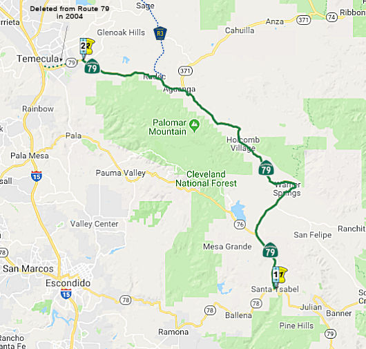 Route 78 near Santa Ysabel to the Temecula city limits east of Butterfield Stage
Road
Route 78 near Santa Ysabel to the Temecula city limits east of Butterfield Stage
Road
Post 1964 Signage HistoryIn 1963, this segment was defined as the route from "Route 78 to Route 71."
Note: in 1965, Chapter 1372 changed (c) to start at "Route 395" instead of "Route 71", but did not change (b) to end at Route 395. This is an odd change, perhaps an error. In 1969, Chapter 294 changed (c) again to start at "Route 15" instead of "Route 395"... again, failing to change (b) to terminate at Route 15. Again, possibly an error.
In 1974, Chapter 537 changed "Route 71" to "Route 15 near Temecula." This reflected the transfer of the portion of Route 71 from I-15 to Aguanga (present-day Route 79/Route 371 junction) from Route 71.
In 1981, Chapter 292 changed the origin of this segment to be "Route 78 near Santa Ysabel"
In 2004, SB 87, Chapter 386, September 8, 2004, relinquished the portion surrounding I-15 within the Temecula City Limits. The actual segment was up for relinquishment in January 2005. This changed the terminus to "the Temecula city limits east of Butterfield Stage Road".
Pre 1964 Signage History In 1934, Route 79 was signed along the route from Jct. US 80
near Descanso to Temecula via Aguanga.
 The portion between Aguanga and Route 15 in Temecula has
a much more colorful signage history. Originally, this portion was also
signed as Route 79. In 1939, US 395 was signed, and this portion became
part of a longer Route 71 that ran to Route 74 E of Anza. At that time,
Route 79 was rerouted up to US 60 W mi W of Beaumont (in the "Badlands")
using what was Route 83 (currently, present-day Riverside County Sign Route R3 and
present-day Route 79). This created a short segment (between Aguanga
and Former Route 83/County Sign Route R3) that was cosigned as Route 71/Route 79, and as
Route 71 between County Sign Route R3 and Temecula. In 1964, as noted below, Route 79 was
routed off of Gilman Springs Road (that became short-lived Route 177) onto
a new routing to Beaumont and I-10. Additionaly, the segment between County Sign Route R3
and Temecula was cosigned Route 79 (although the route was officially
Route 71), and County Sign Route R3 was signed (moving Route 79 off of the segment
through Sage to Hemet, and onto a new routing from Temecula to Hemet). The
segment from County Sign Route R3 to Temecula was resigned as only Route 79 in 1974 when
Route 71 was renumbered.
The portion between Aguanga and Route 15 in Temecula has
a much more colorful signage history. Originally, this portion was also
signed as Route 79. In 1939, US 395 was signed, and this portion became
part of a longer Route 71 that ran to Route 74 E of Anza. At that time,
Route 79 was rerouted up to US 60 W mi W of Beaumont (in the "Badlands")
using what was Route 83 (currently, present-day Riverside County Sign Route R3 and
present-day Route 79). This created a short segment (between Aguanga
and Former Route 83/County Sign Route R3) that was cosigned as Route 71/Route 79, and as
Route 71 between County Sign Route R3 and Temecula. In 1964, as noted below, Route 79 was
routed off of Gilman Springs Road (that became short-lived Route 177) onto
a new routing to Beaumont and I-10. Additionaly, the segment between County Sign Route R3
and Temecula was cosigned Route 79 (although the route was officially
Route 71), and County Sign Route R3 was signed (moving Route 79 off of the segment
through Sage to Hemet, and onto a new routing from Temecula to Hemet). The
segment from County Sign Route R3 to Temecula was resigned as only Route 79 in 1974 when
Route 71 was renumbered.
So why was Route 83 renumbered into Route 79, vs. staying Route 83.
According to Scott Parker on AARoads: The Route 79-for-Route 83 switch
happened only a few years after US 395 was commissioned in CA. Its
original San Diego-Riverside path via Vista, Fallbrook, and Lake Elsinore
was indeed convoluted. Much of that, part of LRN 77, was originally slated
to be Route 71 prior to US 395 entering the picture. But once US 395
happened, it was apparently decided to make Route 79 an eastern parallel
alternative to that route, so it subsumed old Route 83, with Route 71
serving as a northern "feeder" for Route 79, funneling traffic in from
east of L.A. all the way to the Inland Empire. Temecula was nothing more
than a rural junction point until substantial development began in the
mid-60's; the Division of Highways thought it more important to locate
Hemet, at the time the largest town southeast of Riverside, along this
alternate N-S corridor than to serve the smaller town also served by US 395 and Route 71.
(Source: Scott Parker on AARoads, "Re: CA 79", 10/30/2019)
The portion of the Rout between former Route 71 and Route 78 was part of the planned Imperial
Highway. The name "Imperial" refers to the Imperial Valley, which
took its name from the Imperial Land Co., a subsidiary of the California
Development Company charged with reclaiming the water-starved but arable
land east of San Diego for agricultural purposes in the early 1900s. The
company began building canals in 1900, diverting water from the Colorado
River for irrigation, and forming the Salton Sea in the process. The Los
Angeles area wanted to patch together a superhighway that would stretch
from the Pacific all the way to Brawley in the Imperial Valley, a distance
of 215 miles; the route was later extended a few miles farther south to El
Centro. The most route roughly followed the old Butterfield Stage overland
route, established in 1858: across the desert (Route 78) and along
today’s Route 79 to Temecula, where it headed on to Corona via Lake
Elsinore and Temescal Canyon (Route 71, later I-15). There the road turned
left down the Santa Ana Canyon on its way to Yorba Linda (present-day
Route 91) and La Habra (present-day Route 90), then across Los Angeles
County to meet the sea at El Segundo (as Imperial Highway, although it is
paralleled by I-105). The extension to Brawley was along Route 86 The
early Imperial Highway plans involved connecting a patchwork assortment of
roads of varying length and quality. In 1912, a group of Los Angeles
boosters informally known as the Committee of One Hundred, working with
Los Angeles, San Bernardino, Orange, Riverside and Imperial counties,
settled on a route along the edge of the inland Salton Sea that completely
bypassed San Diego County, from which Imperial County had been split off
in 1907. The Los Angeles section of road would be mostly a straight shot
from LAX to Anaheim, where the proposed road would dip south diagonally
before eventually reaching the Imperial Valley. By the 1920s, the efficacy
of the Imperial Highway concept had become apparent, and a new and more
forceful private group, the Imperial Highway Association, was formed in
1929 to encourage the regions involved to mount a fully cooperative
effort, including working closely with San Diego County, to get the job
done. The association adopted an official route for a more streamlined,
uniform highway in 1931 that ran slightly west of the earlier Salton Sea
route. The improved roadway, now referred to informally as “the
Cannon Ball Road,” would eliminate tight right angle turns that
slowed trucks, smooth and widen the various roadways involved, and have
new bridges where necessary. A major section in Yorba Linda was completed
in 1937. Two-lane portions of the highway through Inglewood had to be
expanded to four. A bridge over the Los Angeles River, completed in
1951, eliminated a crucial bottleneck; it replaced an old one that
collapsed in 1948. The final section of the Imperial Highway as envisioned
by the association was completed, and it was dedicated a scenic highway in
a ceremony on the Imperial-San Diego county border in December 1961. Of
its 220 total miles, 77 were county roads, with the rest being state
highways. The cost to complete the project was estimated at $16 million
(about $138 million in 2020 dollars). In 1965, Caltrans planned a new
freeway along the path of Imperial Highway, from LAX to Norwalk. It opened
in 1993 as I-105, though Imperial Highway itself remained in place, if
somewhat less crucial than it once was. Through Orange County, Imperial
Highway was Route 90. Major chunks of the roadway through Riverside and
San Diego counties were subsumed by newer freeways and highways over the
years. The 41-mile Los Angeles stretch, which passes through El Segundo,
Hawthorne, Inglewood, South Los Angeles, Lynwood, South Gate, Downey,
Norwalk, Santa Fe Springs and La Mirada, retains the original Imperial
Highway name, as does a section of Route 86 in El Centro (also known as
Imperial Avenue).
(Source: Daily Breeze, “South Bay History: Imperial Highway once figured as part of a superhighway plan”, 3/29/2021; Orange County History “The Imperial Highway”, 2011)
The segment between Santa Ysabel and Temecula was part of LRN 78, defined in 1933.
 Status
The intersection of Route 371 and Route 79 (~ RIV 2.237) has demonstrated itself to be a high source of accidents, with four deaths occuring in the period from July 2001 to July 2002. As a result, the intersection is being redesigned. Two-lane Route 79 is the main link between Temecula and the Warner Springs and Santa Ysabel areas of San Diego County. Two-lane Route 371 is a well-traveled back road between Southwest County and Palm Springs. Currently, the two roads converge in Aguanga where an oddly configured intersection contributes greatly to the accident count. Westbound traffic on Route 79 must stop at the intersection, while eastbound traffic on Route 79 and traffic coming down a steep curvy grade from Anza on Route 371 proceed without stopping. Beginning in Summer 2003, the intersection will be reconfigured to force drivers heading toward Temecula to stop and turn either left of right at a "T" intersection with Route 371. Turning left would take them quickly back to Route 79. Long-term improvements will include a merger lane from Route 371 to Route 79.
Aguanga Rumble Strips (08-Riverside-79 PM 5.4/11.4)
 In June 2017, the CTC added the following to the SHOPP: 08-Riv-79 5.4/11.4 Route 79: Near
Temecula, from 3.1 miles north of Route 371 to 1.1 miles south of Pauba
Road. Construct 8 foot shoulders and rumble strip $1,705K (R/W) $43,272K
(C) $10,359K (Support) PA&ED: 11/19/2019 R/W: 10/19/2021 RTL:
11/20/2021 BC: 08/20/2022
In June 2017, the CTC added the following to the SHOPP: 08-Riv-79 5.4/11.4 Route 79: Near
Temecula, from 3.1 miles north of Route 371 to 1.1 miles south of Pauba
Road. Construct 8 foot shoulders and rumble strip $1,705K (R/W) $43,272K
(C) $10,359K (Support) PA&ED: 11/19/2019 R/W: 10/19/2021 RTL:
11/20/2021 BC: 08/20/2022
The 2020 SHOPP, approved in May 2020, included the
following Collision Reduction item of interest (carried over from the 2018
SHOPP): 08-Riverside-79 PM 5.4/11.4 PPNO 3006G Proj ID 0816000049 EA
1G670. Route 79 near Temecula, from 3.1 miles north of Route 371 to 1.1
miles south of Pauba Road. Construct eight foot shoulders and rumble
strip. Programmed in FY21-22, with construction scheduled to start in
August 2022. Total project cost is $63,028K, with $44,977K being capital
(const and right of way) and $18,051K being support (engineering,
environmental, etc.).
(Source: 2020 Approved SHOPP a/o May 2020)
In June 2020, the CTC amended the 2020 SHOPP as
follows: 08-Riv-79 5.4/11.4. PPNO 3006G ProjID 0816000049 EA 1G670. On
Route 79 near Temecula, from 3.1 miles north of Route 371 to 1.1 miles
south of Pauba Road. Construct 8 foot shoulders and rumble
strip. Allocation changes: Con Sup $7,700K $8,520K
R/W Cap $1,705K $2,850K Const Cap $43,272K
$57,200K; Total $63,028K $78,921K.
Change description because full 8-foot shoulders will not be built in all
areas. Increase construction capital due to application of cost escalation
rates and due to increased retaining wall costs. Construction support
costs have been re-estimated and increased. Increase R/W capital because
more parcels, temporary easements, and additional mitigation costs are
needed. Construction is delayed one year to address project changes during
design.
(Source: June 2020 CTC Agenda, Agenda Item
2.1a.(5d) #23)
In January 2021, the CTC approved for future
consideration of funding 08-Riv-79, PM 5.4/11.4. SR-79 Construct
Shoulders and Rumble Strips Project. Construct eight-foot paved
shoulders, install rumble strips, and widen Temecula Creek Bridge on Route 79 in Riverside County. (MND) (PPNO 3006G) (SHOPP). The project is located
on Route 79 in Riverside County near Temecula. The project proposes to
construct eight-foot paved shoulders, install rumble strips, and widen the
Temecula Creek Bridge within the project area to reduce the number and
severity of collisions and improve motorist safety. This project is fully
funded and is currently programmed in the 2020 SHOPP for a total of
$78,921,000 that includes Construction (capital and support) and Right of
Way (capital and support). Construction is estimated to begin in 2022-23.
The scope, as described for the preferred alternative, is consistent with
the project scope programmed by the Commission in the 2020 SHOPP. A
Mitigated Negative Declaration (MND) has been completed. The project
will result in less than significant impacts to the environment after
mitigation. The following resource areas may be impacted by the
project: cultural and biological resources. Avoidance and
minimization measures will reduce any potential effects on the
environment. These measures include, but are not limited to, shallow
grading to permit cultural monitoring during construction and
preconstruction surveys to locate special-status plant species prior to
construction.
(Source: January 2021 CTC Agenda, Agenda Item
2.2c.(1))
In January 2021, the CTC approved the following
pre-construction support phase allocation(s): (2a) #26. $5,405,000
(PS&E; $4,700,000 Programmed); $863,000 (R/W Sup; $751,000
Programmed). 08-Riv-79 5.4/11.4. PPNO 08-3006G; ProjID 0816000049; EA
1G670. Route 79 Near Temecula, from 3.1 miles north of Route 371 to 1.1
miles south of Pauba Road. Construct shoulders and rumble strip.
(Concurrent consideration of funding under Resolution E-21-06; January
2021.) Prog Year 22-23.
(Source: January 2021 CTC Agenda, Agenda Item
2.5b.(2a) #26)
In March 2023, the CTC approved an additional $800,000
in Capital Outlay Support (COS), for the SHOPP Safety Improvements project
on Route 79, in Riverside County, to complete the Plans, Specifications,
and Estimates (PS&E) phase. This project is located on Route 79 near
Temecula, from north of Route 371 to south of Pauba Road, in Riverside
County. The project will construct shoulders, retaining walls, and
rumble strip, improve drainage, and install guardrail. The project
realized cost increases during PS&E due to a design change developed
to avoid condemnation of two right of way parcels. This project proposes
to construct safety components along Route 79. The alignment and
features are adjacent to several private properties. In August 2022,
a specific area of the project started to have an issue with falling
rocks. To address this issue, a rock fall protection system had to
be designed. The Department anticipated completing the additional
work within the G-12 allowances; however, the remaining work and available
funds were not in alignment. In September 2022, the Department was
proceeding with the condemnation of two parcels. After condemnation
hearings, the Department was able to determine a solution which will build
retaining walls in lieu of right of way acquisition. As a result,
the project required more resources than what was originally allocated due
to additional design, surveys, geotechnical studies, and environmental
reviews for the three additional retaining walls and the redesign of one
retaining wall. The remaining work and resource needs were analyzed,
and completion of PS&E is expected by November 2023. Therefore,
the project requires and additional $800,000 to complete the PS&E
phase.
(Source: March 2023 CTC Agenda, Agenda Item 2.5e.(9))
In August 2023, the CTC received a report of an SHOPP
Safety Sub-Allocation made by Caltrans on 07/17/2023: $65,505,000.
08-Riv-79 5.4/11.4. PPNO 08-3006G; ProjID 0816000049; EA 1G670. Route 79
Near Temecula, from 3.1 miles north of Route 371 to 1.1 miles south of
Pauba Road. Outcome/Output: Improve safety by constructing shoulders and
rumble strip. This project will reduce the number and severity of
collisions.. Preliminary Engineering (Budget / Expended):
PA&ED $5,590,000 / $5,606,738; PS&E $6,945,500 /
$6,805,664; R/W Sup $1,149,300 / $882,101.
CEQA - MND, 8/26/2020; Re-validation 6/30/2023. NEPA - FONSI, 8/26/2020;
Re-validation 6/30/2023. Future consideration of funding approved under
Resolution E-21-07; January 2021. Two month allocation time extension for
CONST and CON ENG approved under Waiver 23-72; June 2023. SB 1 Baseline
Agreement approval under Resolution SHOPP-P-2021 -04B; January 2021.
Allocation Date: 07/17/2023. Allocation (Programmed / Allocated):
CON ENG $8,520,000 / $10,050,000; CONST $57,200,000 / $55,455,000.
(Source: August 2023 CTC Agenda, Agenda Item 2.5f.(3) #6)
Arroyo Seco Bridge Reconstruction (RIV 9.34)
 In October 2018, it was reported that the CTC authorized funding (as part of a larger package of
bridge funding) to replace Bridge 56-0189 (RIV 9.34, built in 1932) over
the Arroyo Seco. The same package of funding also included replacement of
the bridge at Temecula Creek (likely Bridge 56-0190, RIV 14.43, built in
1939, although there is also Bridge 56-0188, RIV 7.07, built in 1980)
along the city’s east side. This work is set to begin in January
2021
In October 2018, it was reported that the CTC authorized funding (as part of a larger package of
bridge funding) to replace Bridge 56-0189 (RIV 9.34, built in 1932) over
the Arroyo Seco. The same package of funding also included replacement of
the bridge at Temecula Creek (likely Bridge 56-0190, RIV 14.43, built in
1939, although there is also Bridge 56-0188, RIV 7.07, built in 1980)
along the city’s east side. This work is set to begin in January
2021
(Source: Press Enterprise, 10/25/2018)
In May 2020, the CTC approved for future consideration
of funding the Bridge Replacement and Bridge Rail Upgrade project
(08-Riv-74, PM 13.2, 33.9; 08-Riv-79, PM 9.3; 08-Riv-371, PM 65.4), which
will replace one bridge and make improvements to other bridges in
Riverside County. (PPNO 3002C). The project is located in the City of Lake
Elsinore on Route 74, among other locations, in Riverside County. The
Department plans to widen Leach Canyon Bridge on Route 74 to provide
standard shoulder width and upgrade the bridge rail, as well as make
improvements to other bridges. The purpose of the project is to improve
the safety of the traveling public by upgrading bridge rails to meet
current crash and safety standards. This project is fully funded and
currently programmed in the 2018 SHOPP for a total of $12,880,000 which
includes Construction (capital and support) and Right of Way (capital and
support). The total estimated project cost is $14 million. Construction is
estimated to begin fiscal year 2020-2021. The scope, as described for the
preferred alternative, is consistent with the project scope programmed by
the Commission in the 2018 SHOPP.
(Source: May 2020 CTC Agenda, Agenda Item 2.2c.(1))
In August 2020, the CTC approved the following
financial allocation for construction and construction support:
$9,969,000. 08-Riv-74 PM 13.2/34.0. Route 74 In and near the cities of
Lake Elsinore, Perris, Menifee and Hemet, at Leach Canyon Channel Bridge
No. 56-0750 and Blue Ridge Wash Bridge No. 56-0257; also on Route 79 and
Route 371, at Arroyo Seco Bridge No. 56-0189, and Cahuilla Bridge No.
56-0490. Outcome/Output: Upgrade bridge rail on three bridges, replace one
bridge, and extend one culvert. This project will upgrade bridges to meet
current crash and safety standards.
(Source: August 2020 CTC Agenda, Agenda Item
2.5b.(1) #39)
Note: Although SB 87 (9/8/2004) changed the legislative definition to eliminate the portion in the City of Temecula, the bill also noted that the portion within Temecula may (not is, so they wrote the bill wrong) be relinquished. The relinquishment agreement must require that the operations and maintenance of the highways will be administered consistent with professional traffic engineering standards, that appropriate traffic studies or analysis will be performed to substantiate decisions affecting the highways, and that there be allowances for public notice and the consideration of public input on the proximate effects of any proposed decision on traffic flow, residences, or businesses, other than a decision on routine maintenance.
The SAFETEA-LU act, enacted in August 2005 as the reauthorization of TEA-21, provided the following expenditures on or near this route:
Historical RouteThe portion of Route 79 from where it intersects with I-8 at post mile L 0.044 at Japatul Valley Road in the County of San Diego to its intersection at post mile RIV 15.74 at Butterfield Stage Road in the County of Riverside is designated as Historic Highway Route 79. Route 79 begins in the community of Descanso and then climbs and winds through some of southern California’s most historically significant natural and manmade sites. Route 79 then travels through Cuyamaca Rancho State Park, surrounding travelers with geological and geographical landmarks. Route 79 next winds past gold mines, communities, and tiny towns that dot the primeval Cleveland National Forest. In 1600, those already old and overlapping trails that would later become Route 79 marked the way for Spanish explorer Pedro Fages and those riding horses with him. A portion of Highway Route 79 served as a segment of the 2,812-mile Butterfield Overland Mail Route, which was the first transcontinental postal delivery service in the country. In other states, several portions of the Butterfield Overland Mail Route have been officially registered as historic places, reminding today’s travelers of the bravery, determination, and adventurism of those who built and traveled this famous route in the 19th century. Route 79 further winds through Julian, a community that a handful of people founded and in which gold was discovered in 1870 (although the portion through Julian is surprisingly not covered by this resolution). By 1908, when the state began paving Route 79, the route had already been used by army surveyors, pre- and post-Civil War gold miners, American and European settlers, Chinese workers, immigrants from the British Isles, and European immigrants tired of the Austro-Hungarian wars. Route 79 has outstanding natural, cultural, historic, and scenic qualities. Thus, a portion of Route 79 has been recognized for its historical significance and importance in the development of California through designation by Senate Concurrent Resolution 147,Res. Chapter 181, 9/9/2016.
Scenic Route[SHC 263.5] Entire portion.
Freeway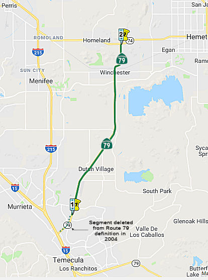 Temecula city limits south of Murrieta Hot Springs Road to Route 74 near Hemet
(b) The relinquished former portions of Route 79 within the City of Temecula and the City of San Jacinto are not state highways and are not eligible for adoption under Section 81. For the relinquished former portions of Route 79, the City of Temecula and the City of San Jacinto shall maintain within their respective jurisdictions signs directing motorists to the continuation of Route 79. The City of Temecula shall ensure the continuity of traffic flow on the relinquished former portions of Route 79 within its jurisdiction, including any traffic signal progression.
Post 1964 Signage HistoryAs defined in 1963, this segment ran from "Route 71 east of Temecula to Route 74 near Hemet." This routing began 4 mi NW of Aguanga on Route 71 (at that time, Route 71 ran from Temecula to 5 mi E of Anza along present-day Route 79 and Route 371), and ran into Hemet via Sage.
In 1965, Chapter 1372 changed this segment to start at "Route 395 near Temecula" instead of "Route 71 E of Temecula"
Scott Parker on AARoads provided some additional information: The
realignment of Route 79 away from its original alignment south of Hemet
over to Winchester Road was done in 1966, a couple of years before I-15
was extended south to San Diego with the batch of 1968 Interstate additions. The reason for doing so was the desire of Caltrans D8 to
relinquish the route from Hemet to the Aguanga area due to not only its
substandard (winding, very poor sight lines) characteristics, but because
the 1959 state Freeway & Expressway system pointedly avoided that
alignment but did include a new-terrain connector from Route 74 southwest
to Temecula that was quite close to the existing Winchester Road. As it
turned out, the Division of Highways simply elected to take over
maintenance of Winchester, bringing it into the system and allowing them
to relinquish old Route 79 (previous Route 83) to Riverside County and the
City of Hemet; it became signed Riverside County Sign Route R3 the following year. This
helped local housing developers; the regional "master plan" contained
plans for numerous large housing tracts flanking the new Route 79 as well
as Route 71 and US 395, accompanied by large-scale commercial development
centered on that portion of Temecula where the realigned Route 79
intersected the US 395/Route 71 combined alignment. Temecula as it is
today (a rather massive exurb) was planned over a half-century ago to be
the regional powerhouse it currently is.
(Source: Scott Parker on AARoads, "Re: CA 79", 10/30/2019)
With respect to the transfer of Route 71 to Route 79 from County Sign Route R3 to
Temecula, Scott noted: The adoption of Route 79 along Winchester Road
threw the area's highway network into chaos -- and this was before I-15
(and I-215) were even on the scene. The Division of Highways had recently
brought the connector from Route 79 near Aguanga northeast to Route 74
(i.e., originally part of Route 71, now Route 371) into the state system
as a "shortcut" from the San Diego area to Coachella Valley cities.
Without it, Route 71 would have simply been truncated to end at Murietta,
north of Temecula (at the site of the present 15/215 split) -- but D8
chose to multiplex Route 71 and Route 79 together for about 20 miles total
to Aguanga, where Route 71 struck out over the new route NE to Route 74
(which was a bit awkward, as Route 71 and Route 74 then intersected one
another twice, at Elsinore and near Anza). This arrangement lasted all of
8 years; after it was decided to route I-15 down Route 71 from Corona
south to Temecula. So, in 1974, D8 simply truncated Route 71 at the (then)
US 395 junction in Murietta, leaving Route 79 as the sole occupant of the
Temecula-Aguanga route; the Anza connector was redesignated as Route 371.
This happened at the same time as the commissioning of Route 330 due to
the reroute of CA 30 away from the San Bernardino mountains and over to
Redlands -- so a 300-series number wasn't an isolated case. Of course,
when I-15 was completed south of Corona, Route71 was cut back to its
Corona-Pomona section, and US 395 was cut back to I-15 at Hesperia, with,
first, I-15E and after 1982 I-215 taking over its routing. But today that
relatively short (about 3 mile) section of I-15 multiplexed with CA 79 in
Temecula is one of the most congested locations in the Inland Empire; and
both adjacent sections of CA 79 itself -- relinquished or not -- are the
two most heavily developed commercial "strips" in the area.
(Source: Scott Parker on AARoads, "Re: CA 79", 10/30/2019)
In 1969, Chapter 294 changed (c) again to start at "Route 15" instead of "Route 395".
In 2004, SB 87, Chapter 386, September 8, 2004, deleted the portion surrounding I-15 within the Temecula City Limits. The actual segment was up for relinquishment in January 2005. This changed the origin to "Temecula city limits south of Murrieta Hot Springs Road": (b) (1) Notwithstanding subdivision (a), the commission may relinquish to the City of Temecula the portion of Route 79 located within Temecula's city limits, upon terms and conditions the commission finds to be in the best interest of the state. (2) Any relinquishment agreement shall require that the City of Temecula administer the operation and maintenance of the highways in a manner consistent with professional traffic engineering standards. (3) Any relinquishment agreement shall require the City of Temecula to ensure that appropriate traffic studies or analysis will be performed to substantiate any decisions affecting the highways. (4) Any relinquishment agreement shall also require the City of Temecula to provide for public notice and the consideration of public input on the proximate effects of any proposed decision on traffic flow, residences, or businesses, other than a decision on routine maintenance. (5) Notwithstanding any of its other terms, any relinquishment agreement shall require the City of Temecula to indemnify and hold the department harmless from any liability for any claims made or damages suffered by any person, including a public entity, as a result of any decision made or damages suffered by any person, including a public entity, as a result of any decision made or action taken by the City of Temecula, its officers, employees, contractors, or agent, with respect to the design, maintenance, construction, or operation of that portion of Route 79 that is to be relinquished to the city. (6) Any relinquishment shall become effective immediately after the county recorder records the relinquishment resolution that contains the commission's approval of the terms and conditions of the relinquishment. (7) On and after the effective date of the relinquishment, both of the following shall occur: (A) The portion of Route 79 relinquished shall cease to be a state highway. (B) The portion of Route 79 relinquished may not be considered for future adoption under Section 81. (8) The City of Temecula shall ensure the continuity of traffic flow on the relinquished portion of Route 79, including any traffic signal progression. (9) For relinquished portions of Route 79, the City of Temecula shall maintain signs directing motorists to the continuation of Route 79.
Pre 1964 Signage HistoryThe original routing of Route 79 in this area (from Aguanga to Hemet via Sage) was LRN 194, defined in 1933. That segment was originally signed as Route 83, and was signed as part of Route 79 in 1938. In 1964, Route 79 was rerouted to a more direct route from I-15 to Route 74 in Hemet, and the original LRN 194 routing was In 1966, was resigned as Riverside County Sign Route R3 in 1966.
The post 1964 routing of this segment never had an LRN. Only the Route 83/County Sign Route R3 portion between Aguanga and Route 15 was signed as Route 79 in 1934; this was later Route 71.
StatusAccording to Don Hagstron in May 2003, there are discussions about a future southward extension of the Route 79 expressway that will bypass Downtown Hemet and San Jacinto and run towards Temecula. The project is delayed, perhaps due to the fact that Riverside County wants to run the expressway all the way up to the existing 6-lane highway portion of Winchester Road (Route 79) that takes you into Temecula and I-15. Don notes that any future Route 79 Freeway that would completely run east of I-215 and south of Hemet appears to be dead due to the protests of Menifee Valley residents who do not want a north-south freeway running through their unincorporated area. Andy Field has a diagram on his Route 125 page that show this proposal, it would be a new north-south freeway corridor that would lead from the current planned northern terminus of Route 125 in Poway north to I-10 in Riverside County, roughly paralleling Interstates 15 and 215 past Escondido, Temecula, and Perris.
Route 79 Realignment Project (~ RIV R15.858 to RIV M33.768)
Note: This spans the next two segments of Route 79.
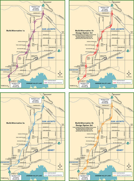 In February 2013, it was reported that there were
feedback sessions on the Route 79 realignment project. The Route 79 Realignment Project is a proposed
realignment of Route 79 between Domenigoni Parkway and Gilman Springs Road
in the San Jacinto-Hemet area. The need for the project is based on a
number of factors, including the following:
In February 2013, it was reported that there were
feedback sessions on the Route 79 realignment project. The Route 79 Realignment Project is a proposed
realignment of Route 79 between Domenigoni Parkway and Gilman Springs Road
in the San Jacinto-Hemet area. The need for the project is based on a
number of factors, including the following:
The Riverside County Transportation Commission (RCTC), the agency responsible for transportation in Riverside County and the administrator of Measure A (Riverside County’s ½ cent sales tax for transportation), has completed environmental studies on a variety of alternatives for the Project. RCTC and Caltrans have prepared and released a Draft Environmental Impact Report/Environmental Impact Statement (Draft EIR/EIS) for public review and comment. The Draft EIR/EIS describes the four proposed Build alternatives and two design options to realign Route 79 to the western area of the San Jacinto Valley. The Build alternatives propose to construct a limited access expressway with two lanes in each direction, divided in the center, with on and off ramps for access. In addition, two of the Build alternatives were revised in response to agency and public input to include a variation (design option) with a lowered roadway profile to reduce visual impacts to surrounding communities, mainly in the area south of Florida Avenue. RCTC and Caltrans accepted comments on the Draft EIR/EIS for 45 days after the release of the document on February 8, 2013. The comment period ended on March 25, 2013.
Alternative 1br was selected as the Preferred
Alternative and the Record of Decision was signed on December 16, 2016 by
Caltrans. The Environmental Document for the project was approved in
December of 2016. The project is in the expenditure plan for Measure A,
Riverside County's ½ cent sales tax measure for transportation, which
will fund a portion of the project. However, the expenditure plan assumed
50% of all project expenses would be paid for with federal and state
transportation funding sources. These sources are currently funded far
below historical levels; therefore, until additional funding is available,
the Commission cannot proceed with right-of-way acquisition or
construction of the project.
(Source: RCTC Route 79 Realignment Project Website)
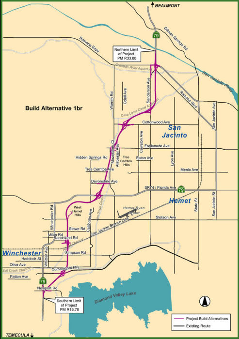 Build Alternative 1br will realign Route 79 from Domenigoni Parkway to Gilman
Springs Road and includes Roadway Segments B, C, G, I, J, M, and N. Local
access connections will include both at-grade intersections and
grade-separated interchanges. Roadway segments will include inside and
outside shoulders, a median, and two lanes traveling in each direction
(henceforth referred to as the Project roadway). The total median width
will be 84 feet (ft) measured from the inside edge of traveled lane on one
side of the roadway to the inside edge of traveled lane on the opposing
side of the roadway. The roadway section includes a median with 5 ft
inside shoulders, 12 ft travel lanes, and 10 ft outside shoulders. Side
slopes will be required outside the shoulders.
Build Alternative 1br will realign Route 79 from Domenigoni Parkway to Gilman
Springs Road and includes Roadway Segments B, C, G, I, J, M, and N. Local
access connections will include both at-grade intersections and
grade-separated interchanges. Roadway segments will include inside and
outside shoulders, a median, and two lanes traveling in each direction
(henceforth referred to as the Project roadway). The total median width
will be 84 feet (ft) measured from the inside edge of traveled lane on one
side of the roadway to the inside edge of traveled lane on the opposing
side of the roadway. The roadway section includes a median with 5 ft
inside shoulders, 12 ft travel lanes, and 10 ft outside shoulders. Side
slopes will be required outside the shoulders.
(Source: RECORD OF DECISION: StateRoute 79 Realignment Project)
The Project has been closely coordinated with Riverside County and the Cities of Hemet and San Jacinto over several years. While the Project would introduce a new highway into areas that have General Plan land use designations other than a major transportation facility, the jurisdictions anticipate the need to update their General Plans and circulation elements once an alignment has been selected. The City of Hemet 2030 General Plan says: “In the event that an alternative alignment or design option is ultimately selected, the City will need to amend the General Plan to indicate the selected roadway configuration” (Hemet 2012).
In October 2018, the CTC approved for future
consideration of funding the following project for which a Final Environmental Impact Report (FEIR) has been completed: Route 79 in Riverside County (08-Riv-79, PM R15.78/R33.8). Construct a new
alignment for a portion of Route 79 in Riverside County. (EA 49400). This
project is located on Route 79 near the cities of Hemet and San Jacinto in
Riverside County. The project proposes to realign Route 79 between
Domenigoni Parkway and Gilman Springs Road. This realignment is proposed
as a divided limited-access expressway by widening from one lane in each
direction to two lanes in each direction. The proposed project addresses
the need to improve traffic flow, reduce diversion of traffic from Route 79 onto local roads, operational efficiency and safety conditions. The
proposed project is currently estimated to cost approximately $1.5 billion
and anticipates funding from Federal designated funds, county measure
funds, Western Riverside Council of Governments, city and local bond
funds. Initial funding is currently programmed in the Federal
Transportation Improvements Program. Construction is estimated to begin in
fiscal year 2018-19.
(October 2018 CTC Agenda Item 2.2c(15))
Note: (1) The northern end of this realignment will connect with the Mid County Parkway Project, which itself would be a bypass of Route 74. In fact, if both are built, there is the possibility that Route 74 might be cosigned with Route 79 to Florida Ave, in lieu of building an eastern connection between the end of the parkway and the eastern edge of Hemet. (2) Given the relinquishment of Route 79 in Hemet, this expressway may serve to reestablish continuity of Route 79.
Freeway[SHC 253.5] Entire portion. Added to the Freeway and Expressway system in 1959.
 Route 74 near Hemet to the San Jacinto city limit near Menlo Avenue.
(b) The relinquished former portions of Route 79 within the City of Temecula and the City of San Jacinto are not state highways and are not eligible for adoption under Section 81. For the relinquished former portions of Route 79, the City of Temecula and the City of San Jacinto shall maintain within their respective jurisdictions signs directing motorists to the continuation of Route 79. The City of Temecula shall ensure the continuity of traffic flow on the relinquished former portions of Route 79 within its jurisdiction, including any traffic signal progression.
(c) (1) Notwithstanding subdivision (a), the commission may relinquish to the City of Hemet the portion of Route 79 that is located within the city limits of that city, upon terms and conditions the commission finds to be in the best interests of the state, if the department and the city enter into an agreement providing for that relinquishment. (2) A relinquishment under this subdivision shall become effective immediately following the county recorder's recordation of the relinquishment resolution containing the commission's approval of the terms and conditions of the relinquishment. (3) On and after the effective date of the relinquishment, the relinquished portion of Route 79 shall cease to be a state highway. (4) The portion of Route 79 relinquished under this subdivision shall be ineligible for future adoption under Section 81. (5) For the portion of Route 79 that is relinquished under this subdivision, the City of Hemet shall maintain within its jurisdiction signs directing motorists to the continuation of Route 79.
Post 1964 Signage HistoryIn 2006, AB 1938, September 18, 2006, authorized relinquishment in San Jacinto: (c) (1) Notwithstanding subdivision (a), the commission may relinquish to the City of San Jacinto any portion of Route 79 that is located within the city limits of that city, upon terms and conditions the commission finds to be in the best interests of the state, if the department and the city enter into an agreement providing for that relinquishment. (2) A relinquishment under this subdivision shall become effective immediately following the county recorder's recordation of the relinquishment resolution containing the commission's approval of the terms and conditions of the relinquishment. (3) On and after the effective date of the relinquishment, the relinquished portion of Route 79 shall cease to be a state highway. (4) The portion of Route 79 relinquished under this subdivision shall be ineligible for future adoption under Section 81. (5) For the portion of Route 79 that is relinquished under this subdivision, the City of San Jacinto shall maintain within its jurisdiction signs directing motorists to the continuation of Route 79.
In July 2007, the CTC relinquished right of way in the city of San Jacinto, under terms and conditions as stated in the cooperative agreement, dated June 4, 2007, determined to be in the best interest of the State. Authorized by Chapter 318, Statutes of 2006, which amended Section 379 of the Streets and Highways Code.
In 2007, SB 224, 10/14/2007, Chapter 718, authorized relinquishment in Hemet: (d) (1) Notwithstanding subdivision (a), the commission may relinquish to the City of Hemet the portion of Route 79 that is located within the city limits of that city, upon terms and conditions the commission finds to be in the best interests of the state, if the department and the city enter into an agreement providing for that relinquishment. (2) A relinquishment under this subdivision shall become effective immediately following the county recorder's recordation of the relinquishment resolution containing the commission's approval of the terms and conditions of the relinquishment. (3) On and after the effective date of the relinquishment, the relinquished portion of Route 79 shall cease to be a state highway. (4) The portion of Route 79 relinquished under this subdivision shall be ineligible for future adoption under Section 81. (5) For the portion of Route 79 that is relinquished under this subdivision, the City of Hemet shall maintain within its jurisdiction signs directing motorists to the continuation of Route 79.
In 2010, SB 1318 (Chapter 421, 9/29/10) split this segment, which was originally "From Route 74 near Hemet to Route 10 near Beaumont."
Pre 1964 Signage History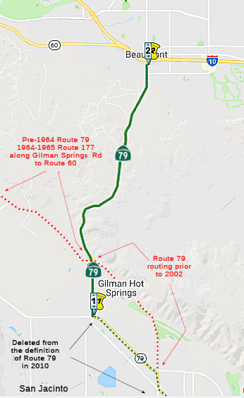 The San Jacinto city limit near Sanderson Avenue to Route 10 near Beaumont.
Post 1964 Signage HistoryThis section was created in 2010 by a split from the preceding segment (AB 1318, Chapter 421, 9/29/10).
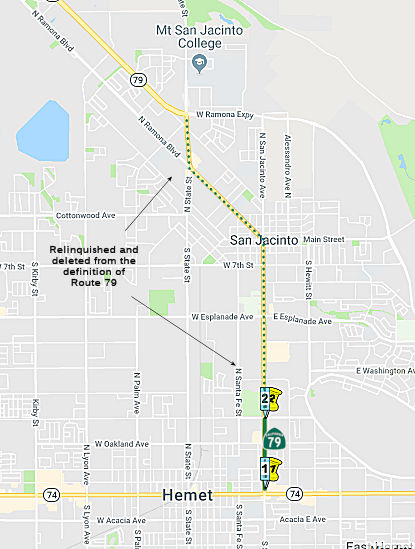
Between the Ramona Expressway and Gilman Springs Road, the routing for Route 79 was changed in July 2002. The original routing ran along Gilman Spring Road and State Street between Ramona Expressway and the Gilman Spring Road/Sanderson Road junction. This was an aging conventional highway with predominantly non-standard shoulders, non-standard horizontal and vertical curves, and an accident rate more than double similar state freeways. In 2002, this routing was relinquished in lieu of a new routing along Ramona Expressway and Sanderson Avenue. This new highway portion has a grade separated interchange and has recently been widened. The claim is that the new routing, in addition to being a better road, allows the property owners on the original routing to preseve the rural character of their area, while reducing vehicle speeds. The background and proposal do not note the rumor that the original routing was a problem for the Church of Scientology, as the Gilman Springs routing runs through the Golden Era Studio operated by the Church. This rerouting was addressed by the CTC in July 2002, when it defined a new routing that ran from 08-Riv-79 PM 29.9/R33.9 in the City of San Jacinto, and PM 29.9 to PM 13.2 in the County of Riverside, and relinquished the segments from from PM 29.9 to 30.9, and from PM 30.5 to 33.4
It appears the routing ran longer along Gilman Springs Road than that. One 1955 map shows Route 79 as continuing along Gilman Springs Road from Sanderson/Lamb Canyon to Route 60 in Moreno. In 1964, that routing was transferred to Route 177, and deleted in 1965. Note that Gilman Springs Road used to be called Foothill Road. At some point, it was rerouted along Lamb Canyon Road to Route 10 near Beaumont.
Pre 1964 Signage HistoryThis segment was not part of the original definition of Route 79 in 1934. It originally was a surface route along Gilman Springs Road between Route 74 and US 60, and was LRN 186. In 1959, the legislative definitions were changed to make the Gilman Springs routing into LRN 186, and a relaxed routing for LRN 194 was defined: [LRN 78] east of Temecula to [LRN 26] near Beaumont via the vicinity of Hemet". This permitted the routing Lamb Canyon. In 1963, a direct route between Hemet and Beaumont was constructed along Lamb Canyon. Until the construction of the route betwen San Jacinto and Beaumont, however, the original LRN 186 was signed as Route 79. The former Gilman Springs Road segment E of Route 79 became Route 177 in 1963.
Freeway[SHC 253.5] Entire portion. Added to the Freeway and Expressway system in 1959.
StatusSan Jacinto Median Barrier (08-Riv-79 PM M32.3/M33.793)
In August 2020, the CTC added the following project to
the 2020 SHOPP: 08-Riv-79 PM M32.3/M33.793 PPNO 3015N ProjID
0819000148 EA 1L080. On Route 79 Near San Jacinto, from Ramona Expressway
/ Sanderson Avenue to Gilman Springs Road (PM M33.793). Construct concrete
median barrier and install ground-in rumble strips. PA&ED $811K;
PS&E $966K; R/W SUP $21K; Con Sup $1,013K; R/W Cap $20K; Const Cap
$3,458K; TOTAL $6,289K. Begin Const 8/16/2022.
(Source: August 2020 CTC Agenda, Agenda Item
2.1a.(2a) #7)
Related to the above, in August 2020 the CTC approved
the following financial allocation: $811,000 for PA&ED.
08-Riv-79 PM M32.3/M33.8. PPNO 3015N ProjID 0819000148 EA 1L080. Route 79
Near San Jacinto, from Ramona Expressway / Sanderson Avenue to Gilman
Springs Road (PM M33.793). Construct concrete median barrier and install
ground-in rumble strips.
(Source: August 2020 CTC Agenda, Agenda Item
2.5b.(2a) #24)
In June 2021, the CTC approved the following
pre-construction allocation: 08-Riv-79 M32.3/M33.8. PPNO 3015N; ProjID
0819000148; EA 1L080. Route 79 Near San Jacinto, from Ramona
Expressway/Sanderson Avenue to Gilman Springs Road (PM M33.793).
Construct concrete median barrier and install ground-in rumble strips.
Allocation: PS&E $1,110,000 ($966,000 programmed); R/W Sup $21,000
(21-22)
(Source: June 2021 CTC Agenda, Agenda Item
2.5b.(2a) #25)
In May 2022, the CTC was informed of the following
SHOPP Safety Resolution G-03-10 Delegated Allocation: $5,156,000.
08-Riv-79 M32.3/M33.793. PPNO 08-3015N; ProjID 0819000148; EA 1L080. Route 79 Near San Jacinto, from Ramona Expressway/Sanderson Avenue to Gilman
Springs Road. Outcome/Output: Construct concrete median barrier and
install ground-in rumble strips to improve safety. This project will
reduce the number and severity of collisions. Allocation: CON ENG
$1,013,000; CONST $3,458,000. Allocation Date: 03/21/2022.
(Source: May 2022 CTC Agenda, Agenda Item 2.5f.(3)
#5)
Lamb Canyon Drainage Project (~ RIV M33.768 to RIV 40.076)
In March 2017, it was reported that median crossovers
for traffic control on Route 79 from Beaumont to San Jacinto have begun as
the California Department of Transportation continues work on the
$1.5-million Lamb Canyon Drainage Project. The Caltrans project will be
installing drainage inlets on Route 79 from Gilman Springs Road near San
Jacinto to First Street in Beaumont (~ RIV M33.768 to RIV 40.076). The
project began Tuesday, March 14, and is expected to be completed by
mid-to-late May. The crossovers will be between County Landfill Road and
just south of the Gilman Springs bridge where Lamb Canyon Road becomes
Sanderson Avenue in San Jacinto. One direction of traffic will be closed
completely, while the traffic is merged to one lane and directed to the
other side of the highway, a Caltrans news release said. The project is
needed to direct water off the highway and into the median, which will
reduce the potential for hydroplaning on this section of Route 79.
Advanced warning signs will be placed to inform motorists of closures and
crossovers.
(Source: My Valley News, 3/24/2017)
In May 2012, the CTC authorized SHOPP funding on Route 79, in Riverside County, 08-Riv-79 R34.2/40.1 In and near Beaumont, from 0.3 mile north of Gilman Springs Road to south of First Street. $190,000 to install ground-in rumble strips on shoulders and place reflective markers on median barrier to improve safety by reducing the number of run-off-the road collisions.
The SAFETEA-LU act, enacted in August 2005 as the reauthorization of TEA-21, provided the following expenditures on or near this route:
Freeway[SHC 253.5] Entire portion. Added to the Freeway and Expressway system in 1959.
 Other WWW Links
 Statistics
Overall statistics for Route 79:
 National Trails
 This route is part of the De Anza National Historic Trail.
 Interregional Route
 Pre-1964 Legislative Route
The route that would become LRN 79 was first defined in 1931 by Chapter 82 as part of "(r) [LRN 2] near Ventura to [LRN 4] at Castaic Junction". This was a well-traveled county highway that followed the Santa Clara River drainage from LRN 4 near Castaic Junction to LRN 2 near Ventura. It provided service for both local traffic (including trucking and domestic movement from ranches and orchards in the valley), as well as Inter-county traffic from points along the coast to points in northwest Los Angeles county. It also provided state-way traffic for travelers from Ventura to or from the state highway over the Tejon Pass into the San Joaquin Valley.
In 1935, this was codified into the highway code as:
In 1939, Chapter 473 extended the routing east along the former [LRN 4] routing to terminate at "[LRN 23] via Castaic Junction and Saugus".
In 1957, Chapter 1911 changed the definition to eliminate the specific routing, terminating it at "[LRN 23] near Solamint".
This was the route between US 101 near Ventura and Route 14 near Solamint. It was signed as Route 126. It ran along the Saugus Ventura Road to US 99, and after 1939, continued briefly cosigned with US 99 to the Ridge Route (now Magic Mountain Parkway) over to San Fernando Road (now Main Street) over to Sierra Highway (US 6, Sign Route 7, now Route 14).
© 1996-2020 Daniel P. Faigin.
Maintained by: Daniel P. Faigin
<webmaster@cahighways.org>.
 Route 78
 Route 80