
 California Highways:
Click here for a key to the symbols used. An explanation of acronyms may be found at the bottom of the page.
 Routing
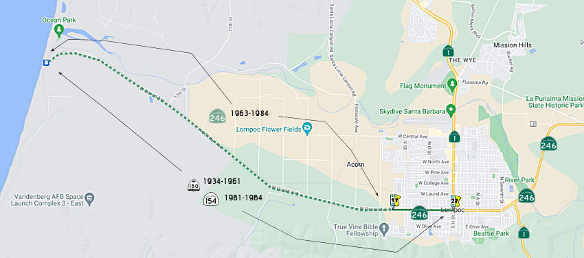 From current west city limits of the City of Lompoc to Route 1.
 Post 1964 Signage History
In 1963, this segment was defined as “(a) Surf to Route 1.”
In 1984, Chapter 1258 deleted the portion from Surf to Lompoc, giving:
“(a) Surf Current west city limits of the City
of Lompoc to Route 1.”
 Pre 1964 Signage History
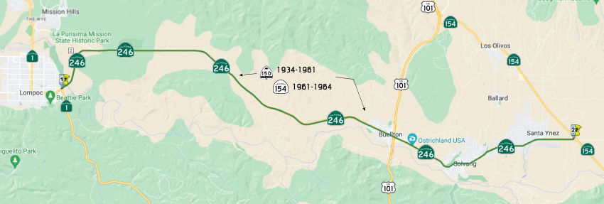
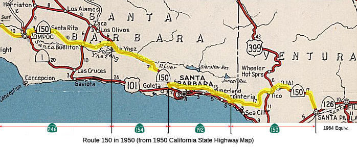 This was all LRN 149, defined in 1933. This was
originally signed as Route 150; in 1961, it was signed as part of Route 154. It was renumbered as part of Route 246 in 1964. It is present-day
Route 246 between Surf (10 mi W of Lompoc) and Route 154 near Santa Ynez.
This was all LRN 149, defined in 1933. This was
originally signed as Route 150; in 1961, it was signed as part of Route 154. It was renumbered as part of Route 246 in 1964. It is present-day
Route 246 between Surf (10 mi W of Lompoc) and Route 154 near Santa Ynez.
 Status
Lompoc Passing Lanes
In August 2014, the CTC approved for future consideration of funding a project that will construct passing lanes on a portion of Route 246 near the City of Lompoc. Based on the project map, the lanes will extend from Cebeda Canyon Road to near Santa Rita Road, a distance of about 8 miles (PM 11.8 to PM R20.9). The total estimated cost is $32,312,000. It is programmed in the 2014 STIP and construction is expected to commence in FY15-16.
In October 2014, the CTC allocated $3,470,000 for the Route 246 Passing Lanes. These will be constructed near Lompoc, from Cebada Canyon Road to Hapgood Road.
In June 2013, the CTC approved delayed construction for a year and adjusted the project scope for a project that would construct passing lanes in each direction from Cebada Canyon Road to Hapgood Road (west), including a four-foot median soft barrier, intersection improvements at Tularosa Road, Hapgood Road (west), and Santa Rita Road, profile improvements at Tularosa Road, and six wildlife crossings.
In May 2016, it was reported that a safety project to
construct passing lanes in both directions on Route 246 near Lompoc from
Cebada Canyon Road to Hapgood Road (East) will continue with paving for a
two-week period near Hapgood Road (East) beginning May 16, 2016. The
contractor for this $14.9 million project is Papich Construction of Pismo
Beach, CA. This project is fully funded by the Santa Barbara County
Association of Governments (SBCAG) Measure A program. It is expected to be
completed in late 2017.
(Source: Edhat Santa Barbara, 5/13/2016)
In October 2016, it was reported that the safety
project to construct passing lanes in both directions on Route 246 near
Lompoc from Cebada Canyon Road to Hapgood Road (East) continues with
earthwork in various locations within the project area.
(Source: Edhat Santa Barbara, 10/4/2016)
In May 2017, the CTC allocated $1,779,000 be allocated from Budget Act Item 2660-001-0042, to provide Construction Support funds to complete construction of this project. A cooperative agreement amendment will be executed with the Santa Barbara County Association of Governments to provide additional $772,000 from the local tax measure to fully fund the Construction Support. The project is located near the City of Lompoc along Route 246 in Santa Barbara County. The scope of work includes constructing passing lanes in both directions of Route 246, improving sight distance by modifying the profile at Tularosa Road and constructing drainage improvements to increase capacity of cross drainage. In addition, left-turn channelization will be provided at local roads and driveways to separate turning vehicles from through traffic. The project will improve the operations of this segment of Route 246 and reduce traffic delays. The project was awarded on March 26, 2015, and the current capital cost estimate is $19,402,000. Construction Capital is funded through Santa Barbara County Tax Measure A. The project is 45 percent complete with 100 percent of the project area disturbed for construction of the improvements. To date, $2,809,702 has been spent on construction support, inspection and management. Construction Support is currently funded by the STIP ($3,470,000). However, an additional $2,551,000 is needed for the current estimate at completion of $6,021,000. Santa Barbara County Association of Governments has agreed to provide $772,000 in Santa Barbara County Tax Measure A funds. Therefore, an additional $1,779,000 in STIP is needed. The increase in the cost estimate for construction support is needed for the additional construction duration of 274 days, due to delays from the effects of winter weather and addressing unforeseen storm damage impacts from the recent winter rains, nesting birds, and change orders for unsuitable material. The construction contract allowed 400 working days (WD) to complete the work. The current estimate to complete the work is now 674 WD. The additional construction support will be spent on completing the construction inspection and management of the project to completion. This amount includes anticipated increases to labor rates over the remaining duration of the project.
In June 2018, it was reported that Caltrans, local law
enforcement and city officials celebrated the completion of the Route 246
passing lanes project. The road connects Lompoc and Buellton in northern
Santa Barbara County. The project added passing lanes in both directions
from Cebada Canyon Road to Hapgood Road East outside of Lompoc. Caltrans
says the completion of the $14.9-million project now allows for safer
passing opportunities for drivers.
(Source: KSBY, 6/13/2018)
The 2022 SHOPP included the following new long lead project: 05-SBA-246
9.55 /R20.9. PPNO 3010; ProjID 0519000122; EA 1M360. Route 246 In and near
Lompoc and Buellton, from Route 1 to east of Domingos Road. Replace
bridge, rehabilitate pavement and drainage systems, construct Class 1 bike
and pedestrian path, and upgrade facilities to Americans with Disabilities
Act (ADA) standards, guardrail and signs. (Additional contribution from
the Santa Barbara County Association of Governments (SBCAG).) Note: Due to
the complexity and duration of environmental studies and permitting,
including biological and cultural resource studies as there is work in the
Santa Ynez River, and relocations of high priority utilities including gas
line and overhead power lines. Total project cost: $87,099K. Begin Con:
1/5/2029.
(Source: “2022 State Highway Operation
And Protection Program, Fiscal Years 2022-23 through 2025-26”,
March 17, 2022)
 Naming
 The portion of Route 246 from SB 9.56, the East
Junction of Route 1/Route 246, in the City of Lompoc, to SB R13.65, La
Purisima (Golf Course), east of the City of Lompoc is officially named the
"Mayor Dick DeWees Memorial Highway" This segment was named in
honor of Dick DeWees, who was elected Mayor of the City of Lompoc on
November 3, 1998, and served six consecutive terms until he passed away on
July 30, 2009. DeWees was born in 1948 in Mount Clemens, Michigan. DeWees
conducted his undergraduate and postgraduate studies at Eastern Michigan
University, majoring in dramatic arts. DeWees worked as an actor and
director in over 60 plays and musicals, appeared on local television and
radio programs, and was a voiceover artist in hundreds of commercials.
DeWees served as master of ceremonies of, and performed with, the Lompoc
Pops Orchestra for over a decade. DeWees served in a variety of positions
in marketing, sales, and administration during 20 years in the
broadcasting industry. DeWees started his own advertising consulting firm
and received the Sam Walton Business Leader Award. DeWees taught public
speaking at the Lompoc Valley Center of Allan Hancock College. Mayor
DeWees served on a variety of boards and committees and represented the
City of Lompoc on the Santa Barbara County Association of Governments and
the Local Agency Formation Commission. Dick DeWees loved being Mayor of
Lompoc, which he often said was the perfect job for him. Mayor DeWees led
the City of Lompoc through many complex and significant achievements,
including a settlement agreement with Cachuma contractors that brings more
water releases to the Lompoc Valley, improving water and wastewater
systems, stabilizing electric rates, extending the life of the city's
landfill, increasing the police force, expanding parks, annexing the Wye
area and entering into a cooperative agreement with Mission Hills to
provide water and sewer services in the Wye area, building an
award-winning aquatic center, opening a new community center, building a
skateboard park, and successfully managing the potential computer risks
referred to as Y2K. Mayor DeWees worked together with the Lompoc City
Council to deal with illegal dumping, graffiti, congregate living,
medicinal marijuana, truck parking, beach closures, fencing, budgets,
labor contracts, reorganizations, low-income housing and housing in-lieu
fees, development impact fees, utility rates, Community Development Block
Grants, facilitating urban county status for Santa Barbara County,
economic development, bus service, airport improvements, library funding,
cable television franchises and public television, historic preservation,
state and local ballot initiatives, WiFi, sidewalks, wineries, bikeways,
energy conservation, water conservation, animal control, police dogs, and
detox centers. Named by Assembly Concurrant Resolution (ACR) 165,
9/14/2010, Resolution Chapter 153.
The portion of Route 246 from SB 9.56, the East
Junction of Route 1/Route 246, in the City of Lompoc, to SB R13.65, La
Purisima (Golf Course), east of the City of Lompoc is officially named the
"Mayor Dick DeWees Memorial Highway" This segment was named in
honor of Dick DeWees, who was elected Mayor of the City of Lompoc on
November 3, 1998, and served six consecutive terms until he passed away on
July 30, 2009. DeWees was born in 1948 in Mount Clemens, Michigan. DeWees
conducted his undergraduate and postgraduate studies at Eastern Michigan
University, majoring in dramatic arts. DeWees worked as an actor and
director in over 60 plays and musicals, appeared on local television and
radio programs, and was a voiceover artist in hundreds of commercials.
DeWees served as master of ceremonies of, and performed with, the Lompoc
Pops Orchestra for over a decade. DeWees served in a variety of positions
in marketing, sales, and administration during 20 years in the
broadcasting industry. DeWees started his own advertising consulting firm
and received the Sam Walton Business Leader Award. DeWees taught public
speaking at the Lompoc Valley Center of Allan Hancock College. Mayor
DeWees served on a variety of boards and committees and represented the
City of Lompoc on the Santa Barbara County Association of Governments and
the Local Agency Formation Commission. Dick DeWees loved being Mayor of
Lompoc, which he often said was the perfect job for him. Mayor DeWees led
the City of Lompoc through many complex and significant achievements,
including a settlement agreement with Cachuma contractors that brings more
water releases to the Lompoc Valley, improving water and wastewater
systems, stabilizing electric rates, extending the life of the city's
landfill, increasing the police force, expanding parks, annexing the Wye
area and entering into a cooperative agreement with Mission Hills to
provide water and sewer services in the Wye area, building an
award-winning aquatic center, opening a new community center, building a
skateboard park, and successfully managing the potential computer risks
referred to as Y2K. Mayor DeWees worked together with the Lompoc City
Council to deal with illegal dumping, graffiti, congregate living,
medicinal marijuana, truck parking, beach closures, fencing, budgets,
labor contracts, reorganizations, low-income housing and housing in-lieu
fees, development impact fees, utility rates, Community Development Block
Grants, facilitating urban county status for Santa Barbara County,
economic development, bus service, airport improvements, library funding,
cable television franchises and public television, historic preservation,
state and local ballot initiatives, WiFi, sidewalks, wineries, bikeways,
energy conservation, water conservation, animal control, police dogs, and
detox centers. Named by Assembly Concurrant Resolution (ACR) 165,
9/14/2010, Resolution Chapter 153.
(Image source: Lompoc Record)
 From Route 1 to Route 154 near Santa Ynez.
Post 1964 Signage HistoryThis route remains as defined in 1963.
Pre 1964 Signage HistoryThis was all LRN 149, defined in 1933. This was originally signed as Route 150; by 1961, it was signed as part of Route 154. It was renumbered as part of Route 246 in 1964. It is present-day Route 246 between Route 1 and Route 154 near Santa Ynez.
StatusIn June 2016, the CTC authorized $6,899,000 for a project on Route 246 in Santa Barbara County (R20.7/26.3) near Buellton, from 0.4 mile east of Santa Rosa Creek Bridge to Route 246/101 Separation. Outcome/Output: Rehabilitate 22.8 lane miles of roadway by grinding existing lanes and shoulders and overlaying with rubberized asphalt to improve the ride quality and extend the service life of the existing pavement. Ramp reconstruction to meet current ADA standards also included.
In December 2009, the CTC relinquished right of way in the city of Solvang along Route 246 at Skytt Mesa Drive (~ SB 28.539), consisting of a collateral facility.
In February 2012, it was reported that the Alisal Bridge, which runs on Route 154 over the Santa Ynez River (Bridge 51-0079, SB R010.12, built in 1971) was determined by Caltrans after a recent inspection to be “structurally deficient,” with cracks and poor structural integrity, according to Solvang Public Works Director Matt van der Linden. The report estimated that the bridge, built in 1972, has about 10 years of viability remaining and recommended a seismic retrofit to reinforce the current structure before replacement. The concerns about the bridge led the Solvang City Council to shift its focus to replacing the Alisal Bridge and delay the improvement and widening project scheduled for the span on Route 246 near Alamo Pintado Road (Bridge 51-0130, SB 030.32, built in 1954, widened in 1972). The cost for replacing the 850-foot Alisal Bridge would be about $19.5 million, according to van der Linden, but it must have the seismic retrofit – a process that reinforces concrete and cabling – before it can receive federal funds. Van der Linden said that grant funding, if authorized by Caltrans, would be available to cover “approximately 88.5% of design and environmental processing costs, and 100% of the construction costs” of the estimated $650,000 retrofit, leaving Solvang on the hook for around $30,000.
Alamo Pintado Creek Bridge № 51-0130 Replacement (05-SBA-246 30.3/31.4)
The 2022 SHOPP included the following new long lead
project: 05-SBA-246 30.3 /31.4. PPNO 3013; ProjID 0519000148; EA 1M420.
Route 246 In and near Solvang, from Alamo Pintado Road to Entrance Road.
Replace bridge, construct Class 1 bike and pedestrian paths, and upgrade
facilities to Americans with Disabilities Act (ADA) standards. (Additional
$1,204,000 contribution from the city of Solvang.) Note: Due to the
complexity and duration of the bridge site over a creek involving
environmental studies that will involve biological and visual resources.
This project will be collaborating with the City of Solvang for complete
streets for connectivity to existing paths. Total project cost:
$32,063K Begin Con: 11/4/2027
(Source: “2022 State Highway Operation
And Protection Program, Fiscal Years 2022-23 through 2025-26”,
March 17, 2022)
In June 2023, the CTC approved the following amendment
to a long-lead project already in the 2022 SHOPP: 05-SB-246 30.3/31.4.
PPNO 05-3013; ProjID 0519000148; EA 1M420. Route 246 In and near Solvang,
from Alamo Pintado Road to Entrance Road. Replace bridge, construct Class
1 bike and pedestrian paths, and upgrade facilities to Americans
with Disabilities Act (ADA) standards. Additional $1,204,000 contribution
from the city of Solvang. Note: Delay all phases due to additional time
needed to complete analysis for fish passage and for review by an
architectural historian. Increase all programmed amounts because costs are
being escalated one year. Allocation Changes ($ × 1,000): PA&ED
$2,473 Prior; ⊘PS&E $3,995
FY24-25 $4,115 FY25-26; ⊘R/W
Sup $501 FY24-25 $516 FY25-26; ⊘Con
Sup $5,161 FY26-27 $5,316 FY27-28; ⊘R/W
Cap $2,675 FY26-27 $2,675 FY27-28; ⊘Const
Cap $17,258 FY26-27 $17,810 FY27-28; TOTAL $32,063
$32,905.
(Source: June 2023 CTC Agenda, Agenda Item 2.1a.(2f) #2)
In August 2011, an editorial indicated that Caltrans is exploring a roundabout at the intersection of Route 246 and Route 154 (~ SB R34.548). The roundabout was later constructed and present as of May 2016.
Naming The intersection of Route 154 and Rout 246 in Santa Barbara County (~ SB R34.548) is named the "Senior
Investigator Laura Jean Cleaves Memorial Junction". It was named in
memory of Laura Jean Cleaves, born on April 19, 1955, in Long Beach,
California. In 1976, Ms. Cleaves joined the Los Angeles County Sheriff's
Department, where she met her future husband, Deputy Stephen M. Cleaves,
and they were married in 1978 and moved to northern California two years
later, where she distinguished herself as the first female police officer
for the City of Arcata. Relocating to Santa Barbara County in 1981, Ms.
Cleaves accepted a position with the Santa Barbara Police Department and,
in 1984, became an investigator with the Santa Barbara County District
Attorney's Office where she excelled as a criminal investigator and was
later promoted to senior investigator. She continually demonstrated
honesty, integrity, professionalism, and leadership in all her varied
assignments. An avid and accomplished horsewoman, Ms. Cleaves wrote
articles on horse care, safety, and riding and provided riding instruction
for those with a love of horses and, in 1988, she began sharing her
expertise as a reserve deputy sheriff and instructor for the Sheriff's
Mounted Unit. Ms. Cleaves had a passion for protecting others, and while
on duty April 30, 2008, her vehicle was struck by a drunken driver and she
suffered a fatal injury. Named by Assembly Concurrent Resolution (ACR)
147, Resolution Chapter 161, on 9/19/2008.
The intersection of Route 154 and Rout 246 in Santa Barbara County (~ SB R34.548) is named the "Senior
Investigator Laura Jean Cleaves Memorial Junction". It was named in
memory of Laura Jean Cleaves, born on April 19, 1955, in Long Beach,
California. In 1976, Ms. Cleaves joined the Los Angeles County Sheriff's
Department, where she met her future husband, Deputy Stephen M. Cleaves,
and they were married in 1978 and moved to northern California two years
later, where she distinguished herself as the first female police officer
for the City of Arcata. Relocating to Santa Barbara County in 1981, Ms.
Cleaves accepted a position with the Santa Barbara Police Department and,
in 1984, became an investigator with the Santa Barbara County District
Attorney's Office where she excelled as a criminal investigator and was
later promoted to senior investigator. She continually demonstrated
honesty, integrity, professionalism, and leadership in all her varied
assignments. An avid and accomplished horsewoman, Ms. Cleaves wrote
articles on horse care, safety, and riding and provided riding instruction
for those with a love of horses and, in 1988, she began sharing her
expertise as a reserve deputy sheriff and instructor for the Sheriff's
Mounted Unit. Ms. Cleaves had a passion for protecting others, and while
on duty April 30, 2008, her vehicle was struck by a drunken driver and she
suffered a fatal injury. Named by Assembly Concurrent Resolution (ACR)
147, Resolution Chapter 161, on 9/19/2008.
(Image source: Officer Down Memorial Page)
 National Trails
 This route is part of the De Anza National Historic Trail.
 Other WWW Links
 Statistics
Overall statistics for Route 246:
 Pre-1964 Legislative Route
In 1959, Chapter 1062 defined LRN 246 as “[LRN 238] near Elkhorn to [LRN 17] near Auburn”. This is present-day Route 102. It ran along Elkhorn Blvd and Greenback Lane to Folsom, and then N along Folsom Road into Auburn.
© 1996-2020 Daniel P. Faigin.
Maintained by: Daniel P. Faigin
<webmaster@cahighways.org>.
 Route 245
 Route 247