
 California Highways:
Click here for a key to the symbols used. An explanation of acronyms may be found at the bottom of the page.
 Routing
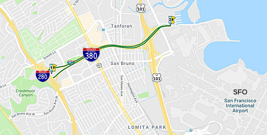
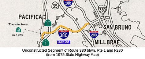 From Route 1 near Pacifica to Route 280 in San Bruno.
 Post 1964 Signage History
In 1969, Chapter 294 defined Route 380 via a transfer from Route 186 as “(a) Route 1 near Pacifica to Route 280 in San Bruno. (b) Route 280 in San Bruno to Route 101 in the vicinity of the San Francisco International Airport. (c) Route 101 in the vicinity of the San Francisco International Airport to Route 87.” This segment remains as defined in 1963. In 1970, Chapter 1473 deleted segment (c)
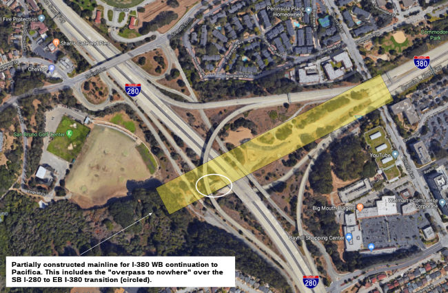
This segment would have been signed Route 380, as it was never planned to be part of the Interstate system. It would have curled through the hills, crossed Route 1, and continued slightly west before curving south to meet Route 1 again. Terrain and seismic problems (the route would cross over the San Andreas Fault) are what killed this segment of freeway. There has been talk in times past of extending 380 to Skyline Blvd, but no serious proposal has come forth for that.
 According to Chris Sampang, the Sneath Lane/San Bruno
Avenue exit off of I-280 (both southbound and northbound) has several
signs of the planned interchange to Route 380 west:
According to Chris Sampang, the Sneath Lane/San Bruno
Avenue exit off of I-280 (both southbound and northbound) has several
signs of the planned interchange to Route 380 west:
Through analysis of maps, Chris has identified a possible routing: I-380 would've continued west of the current Y interchange with I-280 first through a path between Claremont Drive and Crestmoor Drive headed to Skyline Boulevard (Route 35). Route 380 would've met near the San Bruno Avenue and Skyline Boulevard junction; most of the possible ROW is currently either forested or parkland. West of Route 35, Route 380 would've crossed the San Bruno City Limit and straddled it on the south side, following trails in the Golden Gate National Recreation Area in Sweeney Ridge as it entered Pacifica. It would follow some paved trails to the junction of Mori's Point Road, Bradford Way, and Route 1; this just also happens to be the current south end of the Route 1 freeway (and may imply that this south end of the Route 1 freeway was to have been directly connected into Route 380). Past Route 1, Route 380 would head southwest at a 20 degree angle or so away from Mori Point but towards the coast; at the coast, the freeway would make its southward turn back to Route 1. Another map that illustrates this quite well can be found here.
In March 2021, there was an interesting article on what was lost during
construction of the freeways. In the late 1960s, community members blocked
I-380 from being extended to the coast (as noted above). During this time,
the Division of Highways simply appraised and took whatever was in the
path. Among the properties taken for I-380 was a naval base across the
street from the Tanforan racetrack. Some 81 homes were taken, among them
one on Seventh Avenue in San Bruno for $10,760 in 1967.
(Source: Climate Online, 3/16/2021)
 Status
 Part (1) is unconstructed. According to the 2013 Traversable Routing Report, the traversable local streets are San Bruno Avenue and
Sharp Parks Road, but no local roads adequately fit the description of a
state highway. The freeway routing was rescinded effective 3/29/1979. The
city of Pacifica was to improve Sharp Park Road but the proposed
improvements do not meet state standards.
Part (1) is unconstructed. According to the 2013 Traversable Routing Report, the traversable local streets are San Bruno Avenue and
Sharp Parks Road, but no local roads adequately fit the description of a
state highway. The freeway routing was rescinded effective 3/29/1979. The
city of Pacifica was to improve Sharp Park Road but the proposed
improvements do not meet state standards.
 Pre 1964 Signage History
This route was LRN 229, defined in 1947.
 Naming
 The Caltrans "Naming" document indicates that this section is named the "Portola Freeway". Gaspar de Portola
was California's first Spanish governor. In 1769 marched north from San
Diego in command of the first party of Europeans to see San Francisco Bay.
This expedition also discovered the Golden Gate and Carquinez Straits. He
founded the presidio at Monterey and aided in establishing Mission San
Carlos. Named by Assembly Concurrent Resolution 113, Chapt. 217 in 1970.
The Caltrans "Naming" document indicates that this section is named the "Portola Freeway". Gaspar de Portola
was California's first Spanish governor. In 1769 marched north from San
Diego in command of the first party of Europeans to see San Francisco Bay.
This expedition also discovered the Golden Gate and Carquinez Straits. He
founded the presidio at Monterey and aided in establishing Mission San
Carlos. Named by Assembly Concurrent Resolution 113, Chapt. 217 in 1970.
(Image source: SLO Tribune)
 From Route 280 in San Bruno to Route 101 in the vicinity of the San Francisco
International Airport.
From Route 280 in San Bruno to Route 101 in the vicinity of the San Francisco
International Airport.
Post 1964 Signage HistoryIn 1969, Chapter 294 defined Route 380 via a transfer from Route 186 as “(a) Route 1 near Pacifica to Route 280 in San Bruno. (b) Route 280 in San Bruno to Route 101 in the vicinity of the San Francisco International Airport. (c) Route 101 in the vicinity of the San Francisco International Airport to Route 87.” This segment remains as defined in 1963. In 1970, Chapter 1473 deleted segment (c)
This segment was authorized for interstate construction by the December 1968 Federal Aid Highway Act, which provided $31.2 milllion for construction of the 1.6 mile segment.
Pre 1964 Signage HistoryThis route was LRN 229, defined in 1947.
StatusThe interchange with Route 280 is "beefier" than usual because of the original planned continuation to Pacifica.
 After the construction of the Bay Bridge in 1933, San Francisco began considering duplicating the bridge and running a
second one further south across the bay. Enter Frank Lloyd Wright, the
famed organic architect whose idea and design for a second Bay Bridge
never came to fruition. The noted architect hated the idea of a second
steel structure similar to the San Francisco–Oakland Bay Bridge.
Partnering with engineer Jaroslav J. Polivka, Wright proposed a concrete
"Butterfly Bridge,” spanning from Army Street (now Cesar Chavez) and
Third Street to its eastern terminus on Bay Farm Island, just north of the
Oakland Airport. Wright and Polivka saw steel truss bridges as extravagant
and obsolete, so the design was all reinforced concrete, resting on a
series of giant hollow almond-shaped piers—which they claimed to be
earthquake-proof construction. Long curved arms would carry six lanes of
traffic and two pedestrian walkways, supported by two arches connected by
a butterfly-shaped garden park (!) as “a pleasant relief and perhaps
a stopping point for the traffic.” The Butterfly Bridge project lost
steam after plans for the underwater—and vastly more
important—Transbay Tube were unveiled, a project that connected BART
from San Francisco to Oakland.
After the construction of the Bay Bridge in 1933, San Francisco began considering duplicating the bridge and running a
second one further south across the bay. Enter Frank Lloyd Wright, the
famed organic architect whose idea and design for a second Bay Bridge
never came to fruition. The noted architect hated the idea of a second
steel structure similar to the San Francisco–Oakland Bay Bridge.
Partnering with engineer Jaroslav J. Polivka, Wright proposed a concrete
"Butterfly Bridge,” spanning from Army Street (now Cesar Chavez) and
Third Street to its eastern terminus on Bay Farm Island, just north of the
Oakland Airport. Wright and Polivka saw steel truss bridges as extravagant
and obsolete, so the design was all reinforced concrete, resting on a
series of giant hollow almond-shaped piers—which they claimed to be
earthquake-proof construction. Long curved arms would carry six lanes of
traffic and two pedestrian walkways, supported by two arches connected by
a butterfly-shaped garden park (!) as “a pleasant relief and perhaps
a stopping point for the traffic.” The Butterfly Bridge project lost
steam after plans for the underwater—and vastly more
important—Transbay Tube were unveiled, a project that connected BART
from San Francisco to Oakland.
(Source: Curbed SF, 12/8/2017)
Rep. Richard J. Welch of San Francisco believed that
another span was not only a good idea, but a necessity. The
Chronicle’s May 1, 1946, edition reported that a joint Army-Navy
board of engineers was brought in to respond to the controversy and rule
on whether plans would proceed. Why an Army-Navy board? Army permission
was needed before a navigable waterway could be bridged or dammed, and the
Navy, with many installations in the Bay Area, had expressed opposition to
another Bay Bridge. The recommendation was for a low-level, six-lane
combination trestle and tube from the foot of Army Street in San Francisco
to the foot of Fifth Street in Alameda. “Immediate”
construction was urged. The next day’s Chronicle read:
“Another bridge between San Francisco and the East Bay was assured
yesterday.” The figure to the right shows the New Trans-Bay Bridge
proposal, submitted by Kenneth B. Jones to the Army-Navy board, would exit
San Francisco at Army Street and arrive in the East Bay just south of the
Alameda Naval Air Station.
(Source: SF Chronicle; 12/11/2017)
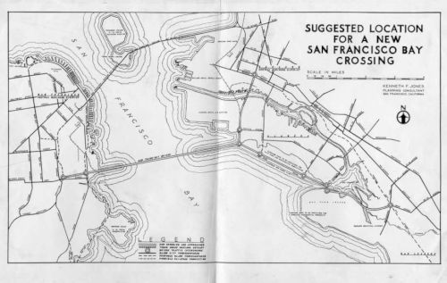
![[Southern Crossing]](maps/southern_crossing.jpg) This map shows the proposed Southern Crossing. This would have been an additional crossing S of the
Bay Bridge, terminating in Oakland (two approaches in Oakland: one along
Alameda and one along Doolittle to the I-880/Hegenberger interchange). The
history of the Southern Crossing goes back at least to 1948, when the
state department of public works prepared a report on additional toll
crossings of San Francisco Bay. This report noted "Because of the
increasing congestion on the San Francisco-Oakland Bay Bridge, the
California Toll Bridge Authority, on Oct 30, 1945, directed the Department
of Public Works to make comprehensive studies for another bay crossing
between SF and the East Bay cites. On Jan 31, 1947, the department
recommended construction of an additional bridge just north of and
parallel to the existing bridge—a plan which is now known as the
Parallel Bridge." This report provided an estimated cost for the Parallel
Bridge of $155,014, 000, and an estimate for the Southern Crossing of
$178, 421, 000. The original concept of the Southern Crossing is
illustrated to the right. There's an extensive discussion of the Southern
Crossing and the Parallel Crossing in the November-December 1947 issue of California Highways and Public Works. There's also a discussion on how the Trafficways report showed this version of the
Southern Crossing, and how the intent was to have Army Street feed into
it, on the Found SF page "A Brief History of Cesar Chavez/Army Street".
This map shows the proposed Southern Crossing. This would have been an additional crossing S of the
Bay Bridge, terminating in Oakland (two approaches in Oakland: one along
Alameda and one along Doolittle to the I-880/Hegenberger interchange). The
history of the Southern Crossing goes back at least to 1948, when the
state department of public works prepared a report on additional toll
crossings of San Francisco Bay. This report noted "Because of the
increasing congestion on the San Francisco-Oakland Bay Bridge, the
California Toll Bridge Authority, on Oct 30, 1945, directed the Department
of Public Works to make comprehensive studies for another bay crossing
between SF and the East Bay cites. On Jan 31, 1947, the department
recommended construction of an additional bridge just north of and
parallel to the existing bridge—a plan which is now known as the
Parallel Bridge." This report provided an estimated cost for the Parallel
Bridge of $155,014, 000, and an estimate for the Southern Crossing of
$178, 421, 000. The original concept of the Southern Crossing is
illustrated to the right. There's an extensive discussion of the Southern
Crossing and the Parallel Crossing in the November-December 1947 issue of California Highways and Public Works. There's also a discussion on how the Trafficways report showed this version of the
Southern Crossing, and how the intent was to have Army Street feed into
it, on the Found SF page "A Brief History of Cesar Chavez/Army Street".
 In 1954, it was reported that the plan for the Southern Crossing had changed
again. The western terminus would be in the vicinity of Third and Army in
San Francisco, and the eastern terminus would be on Bay Farm Island in
Alameda County. In 1954, the State Dept of Public Works applied to the
Army Corps of Engineers for permission to construct the crossing. Approval
was granted 4/8/1954 to construct a causeway-tube crossing on an alignment bowed southwards. The plan was for a six-lane tube 7.7 mi in length. Starting in San Francisco, there would be a trestle viaduct approx 5,300' long to a sand island, where traffic would enter one of three 5,800' tubes. They would emerge at another sand island, continue across a low concrete trestle viaduct 22,000' long and then to a 6,000' earthen mole to the SW shore of Bay Farm Island. The route would connect on the Western side with the Bayshore (US 101) Freeway between 25th and 26th Streets and between Tennessee Street and the Embarcadero (I-280) Freeway. The east bay side would connect with the Posey and Webster Street Tubes (Route 260). It was estimated that the project would take 65,000 tons of reinforcing steel; 1 million cubic yards of concrete; 1.5 million barrels of cement; 10,000 tons of structural steel; and 14 million cubic yards of sand. In 1957, it was reported that a study showed that the crossing would not be financially feasible at a toll rate of 25¢, and that it would not be possible to finance construction.
In 1954, it was reported that the plan for the Southern Crossing had changed
again. The western terminus would be in the vicinity of Third and Army in
San Francisco, and the eastern terminus would be on Bay Farm Island in
Alameda County. In 1954, the State Dept of Public Works applied to the
Army Corps of Engineers for permission to construct the crossing. Approval
was granted 4/8/1954 to construct a causeway-tube crossing on an alignment bowed southwards. The plan was for a six-lane tube 7.7 mi in length. Starting in San Francisco, there would be a trestle viaduct approx 5,300' long to a sand island, where traffic would enter one of three 5,800' tubes. They would emerge at another sand island, continue across a low concrete trestle viaduct 22,000' long and then to a 6,000' earthen mole to the SW shore of Bay Farm Island. The route would connect on the Western side with the Bayshore (US 101) Freeway between 25th and 26th Streets and between Tennessee Street and the Embarcadero (I-280) Freeway. The east bay side would connect with the Posey and Webster Street Tubes (Route 260). It was estimated that the project would take 65,000 tons of reinforcing steel; 1 million cubic yards of concrete; 1.5 million barrels of cement; 10,000 tons of structural steel; and 14 million cubic yards of sand. In 1957, it was reported that a study showed that the crossing would not be financially feasible at a toll rate of 25¢, and that it would not be possible to finance construction.
(Image source: San Francisco Examiner, 8/27/1954 via Joel Windmiller, 2/13/2023)
Later plans had the route originating from the east side of the bay near Bay Farm Island (fed by a new interstate, I-980), crossing to the west side, and landing on the San Francisco peninsula in the Bayview neighborhood, at Hunters Point, where it would connect with I-280. The vision was to provide East Bay motorists on I-580 and Route 24 with a direct connection to I-280. In 1961, the Southern Crossing bridge came close to construction, but environmental activists concerned about the environmental degradation of the Bay prevented the project from moving forward. Even though the bridge was dead, construction of I-980 moved ahead in the heart of Oakland, starting over two decades of work that would ultimately divide Black residents in West Oakland from downtown and demolish over 500 homes and nearly two dozen businesses and churches.
(Source: Transportation for America, 3/8/2023)
 In 1971, a bill for the construction of the Southern
Crossing was passed in the California State Assembly by both houses but
vetoed by then-Governor Ronald Reagan, who believed that the citizens of
the Bay Area should weigh in on the decision to construct such an
expensive and controversial infrastructure project. Voters rejected a bond
measure in 1972 that would have paid for the construction of the bridge
via a toll increase on existing bridge infrastructure by a three-to-one
margin. Without the bridge, the finally completed, roughly two-mile
stretch of I-980 ended abruptly at 18th Street. See the page on I-980 for
the issues revolving around that segment. The page on the history of Army
Street and Cesar Chavez notes that in 1971, even after most other San
Francisco freeway projects have been abandoned, California Freeway
Planning Map still showed the proposed Southern Crossing (however, the map
image does not appear to be from the state highway map of 1970).
Evidently, Army Street/Cesar Chavez would have been a major feeder into
the Southern Crossing. In support of this, in 1973, the Army Street/US 101
Spaghetti Bowl interchange was built, replacing the roundabout that
previously linked Army with Potrero Ave. and Bayshore Blvd. The new
interchange was intended in part to serve traffic coming from and going to
a future Southern Crossing:
In 1971, a bill for the construction of the Southern
Crossing was passed in the California State Assembly by both houses but
vetoed by then-Governor Ronald Reagan, who believed that the citizens of
the Bay Area should weigh in on the decision to construct such an
expensive and controversial infrastructure project. Voters rejected a bond
measure in 1972 that would have paid for the construction of the bridge
via a toll increase on existing bridge infrastructure by a three-to-one
margin. Without the bridge, the finally completed, roughly two-mile
stretch of I-980 ended abruptly at 18th Street. See the page on I-980 for
the issues revolving around that segment. The page on the history of Army
Street and Cesar Chavez notes that in 1971, even after most other San
Francisco freeway projects have been abandoned, California Freeway
Planning Map still showed the proposed Southern Crossing (however, the map
image does not appear to be from the state highway map of 1970).
Evidently, Army Street/Cesar Chavez would have been a major feeder into
the Southern Crossing. In support of this, in 1973, the Army Street/US 101
Spaghetti Bowl interchange was built, replacing the roundabout that
previously linked Army with Potrero Ave. and Bayshore Blvd. The new
interchange was intended in part to serve traffic coming from and going to
a future Southern Crossing:
(Source: Transportation for America, 3/8/2023; FoundSF "A Brief History of Cesar Chavez/Army Street", August 2023)
The San Francisco Board of Supervisors cited an increase in traffic that it said would bring more smog and congestion to the city. Foley brushed aside the votes. San Francisco had for 10 years supported the plan, he argued, and the Bridge Authority didn’t need the city’s approval anyway. Powerful Assemblyman Leo Ryan weighed in, saying the second crossing would be a disaster for the recently opened BART system and a “blow to the tenuous ecological balance of the bay.” A bond measure on the ballot in 1972 would have funded a planned crossing from Hunters Point and Alameda, but voters rejected it.
The University of California, Berkeley, has an online library exhibit that contains a lot of information about this unbuilt crossing; you can find it at http://www.lib.berkeley.edu/news_events/bridge/ . This would have come approximately from the Route 82/Route 87 junction It is possible that Route 87 may have been the Southern Crossing.
I-380/I-238 Proposals
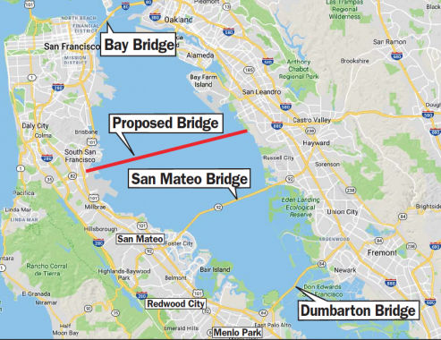
There were later Southern Crossing proposals, for example, one in 1996 proposed extending Route 238 to Daly City. Note that the Southern Crossing isn't dead yet. In July 2001, the California Transportion Commission was funding a study regarding to the feasibility of a Southern Crossing. However, this later version would have run from I-380 at the top of the San Francisco International Airport to the bottom of the Oakland Airport, for a much longer crossing.
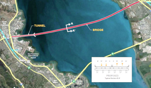
The San Francisco Bay Crossings Study, dated June 2002, had construction of a new Mid-Bay Bridge (mistakenly called by some the "Southern Crossing", but the actual proposed Southern Crossing was further north) as Alternative 4. This bridge would have connected I-380 to Route 238 in the East Bay. This alternative assumed a connection between I-380 on the west end, just N of San Francisco International Airport, and Route 238. The connection would cross at one of the widest points in the San Francisco Bay. The overall length of the structure would be 13.5 miles, and be the 6th longest bridge, just behind Florida's Sunshine Skyway Bridge. It the main span was connected as 850 feet as proposed in the study, it would be the 5th longest orthotropic steel box girder span in the world.
The crossing itself would consiste of the bridge structure from the East Toll Plaza to the apporaches at the I-380 interchange. There would be an east and west causeway, and a High Bridge spanning the shipping channel. The causeways would be trestle structures similar to the existing San Mateo Bridge. The SFO Airport Obstruction Clearance Line and glide path would preclude a cable-stayed, suspension, or extradosed type bridge; hence, the High Bridge would be comprised mostly of long-span precast concrete segmental box girders. These would have to be lightweight, as the girder structure would be at the maximum span range (750-850 ft) for this type of bridge in a high seismic region. The causeways would be approximately 12.1 miles long, with the high bridge being approximately 1.1 miles long. The capital cost estimates for this are phenominal: costs for the alternative, including the crossing, approach, right of way acquisition, and transit bus rolling stock, would run from $6.646 billion to $8.245 billion dollars, with operation and maintenance costs of $35 million annually.
In September 2002, the CTC had on its agenda TCRP Project #11, requested by the Metropolitan Transportation Commission (MTC), to fund $1.8M for completing the feasibility and financial studies for the new crossing alternatives. The TCRP allocated $5,000,000.
 In November 2010, the "Southern Crossing" proved itself
the proposal that wouldn't die. In early November 2010, saying its mission
is to look at long-term options for traffic relief, the Bay Area Toll
Authority's oversight committee considered authorizing a $400,000 study on
the Southern Crossing Bridge between I-238 in San Lorenzo and I-380 in San
Bruno. The odds of the bridge are low: There was no clamor to build the
bridge after a study in 2002 estimated the price tag at $8.2 billion. The
money for the study would come from tolls collected on seven state-owned
toll bridges in the region. Planning consultants hired by the authority
would take about six months to update technical information about the
Southern Crossing bridge and alternatives for reducing traffic congestion.
The toll authority will use the study findings to decide whether to
conduct a second, more detailed study with recommendations on whether to
build the new bridge. The bridge study would examine the feasibility of
developing express bus lanes or rail service on the bridge in addition to
lanes for car traffic. Plans for a new bridge spanning the bay have been
considered, and rejected for environmental and other concerns, at least
five times since 1947. They range from a mirror-image twin of the Bay
Bridge to an eight-lane highway and BART bridge from San Leandro to San
Bruno and a two-legged bridge shaped like the letter "Y" with one leg to
Alameda, the other to San Leandro. Information on this study can be found
here.
In November 2010, the "Southern Crossing" proved itself
the proposal that wouldn't die. In early November 2010, saying its mission
is to look at long-term options for traffic relief, the Bay Area Toll
Authority's oversight committee considered authorizing a $400,000 study on
the Southern Crossing Bridge between I-238 in San Lorenzo and I-380 in San
Bruno. The odds of the bridge are low: There was no clamor to build the
bridge after a study in 2002 estimated the price tag at $8.2 billion. The
money for the study would come from tolls collected on seven state-owned
toll bridges in the region. Planning consultants hired by the authority
would take about six months to update technical information about the
Southern Crossing bridge and alternatives for reducing traffic congestion.
The toll authority will use the study findings to decide whether to
conduct a second, more detailed study with recommendations on whether to
build the new bridge. The bridge study would examine the feasibility of
developing express bus lanes or rail service on the bridge in addition to
lanes for car traffic. Plans for a new bridge spanning the bay have been
considered, and rejected for environmental and other concerns, at least
five times since 1947. They range from a mirror-image twin of the Bay
Bridge to an eight-lane highway and BART bridge from San Leandro to San
Bruno and a two-legged bridge shaped like the letter "Y" with one leg to
Alameda, the other to San Leandro. Information on this study can be found
here.
MTC looked into the southern crossing in 2012, where the bridge would connect Route 238 in Hayward to I-380 in San Bruno. The Hayward to San Bruno bridge, along with a BART tunnel, would cost up to $12.4 billion, according to a May 2012 presentation to the Bay Area Toll Authority. Rentschler said while Feinstein’s wish for a southern connection is “compelling,” the bigger challenge is getting traffic to flow on either side of the new bridge. According to the May 2012 presentation, at least 61,300 people a day would use the new bridge, and around 27,100 of those would be new transbay trips. Reinstating the defunct Dumbarton Rail corridor — an abandoned rail line that goes from Redwood City to Menlo Park and then across the Bay on a run down railroad trestle — and improving the San Mateo Bridge are alternatives to an entirely new bridge.
 In December 2017, the Southern Crossing
reappeared in a proposal from Senator Dianne Feinstein, who renewed her
call for a new east-west transbay bridge somewhere south of the
always-congested Bay Bridge. Feinstein, D-Calif., has repeatedly called
since 2000 for a Southern Crossing, an idea that has been around since the
1940s, but has been rejected in recent years as too costly and
environmentally problematic. On Wednesday, joined by Rep. Mark DeSaulnier,
D-Concord, she sent a letter to Steve Heminger, executive director of the
Metropolitan Transportation Commission. The letter chastised the
commission for not moving forward on a new transbay span. Its authors said
it would relieve Bay Bridge congestion, and that it should be funded by
Regional Measure 3, a ballot measure — written, but not yet
scheduled — that could raise tolls on state-owned toll bridges by as
much as $3. MTC spokesman Randy Rentschler acknowledged receipt of the
letter. He said the commission appreciated the acknowledgment of the need
for major investment in Bay Area infrastructure. The letter, he said, will
be taken seriously. But Rentschler did not commit to undertaking a new
bay-crossing study, pointing out that it’s not on the list of
projects the Legislature approved when it agreed to let the Bay Area vote
on Regional Measure 3 to raise its tolls. Several versions of a Southern
Crossing have been proposed through the decades, none of which has been
undertaken. After Feinstein floated the idea in 2000, the commission
undertook a two-year study of what it would cost. It concluded that
building a bridge from Route 238 in Hayward to the Peninsula would cost
$8.2 billion, saying that was cheaper than a new BART tube between San
Francisco and Oakland but still costlier than the Bay Area could probably
afford. Another two-year study, completed in 2012, estimated the cost of a
bridge that would carry both cars and some form of transit, at $12.4
billion. Both studies assumed a new crossing that would be built from
I-380, in San Bruno, to I-238 in San Leandro. The letter from Feinstein
and DeSaulnier included no specifics but did mention “the need for
an additional route for both BART and vehicular traffic.” On
Wednesday the SamTrans board approved the Dumbarton Corridor study, which
is a plan that calls for increasing the frequency of buses across the
current Dumbarton bridge and rebuilding the rail bridge for Caltrain or
BART.
In December 2017, the Southern Crossing
reappeared in a proposal from Senator Dianne Feinstein, who renewed her
call for a new east-west transbay bridge somewhere south of the
always-congested Bay Bridge. Feinstein, D-Calif., has repeatedly called
since 2000 for a Southern Crossing, an idea that has been around since the
1940s, but has been rejected in recent years as too costly and
environmentally problematic. On Wednesday, joined by Rep. Mark DeSaulnier,
D-Concord, she sent a letter to Steve Heminger, executive director of the
Metropolitan Transportation Commission. The letter chastised the
commission for not moving forward on a new transbay span. Its authors said
it would relieve Bay Bridge congestion, and that it should be funded by
Regional Measure 3, a ballot measure — written, but not yet
scheduled — that could raise tolls on state-owned toll bridges by as
much as $3. MTC spokesman Randy Rentschler acknowledged receipt of the
letter. He said the commission appreciated the acknowledgment of the need
for major investment in Bay Area infrastructure. The letter, he said, will
be taken seriously. But Rentschler did not commit to undertaking a new
bay-crossing study, pointing out that it’s not on the list of
projects the Legislature approved when it agreed to let the Bay Area vote
on Regional Measure 3 to raise its tolls. Several versions of a Southern
Crossing have been proposed through the decades, none of which has been
undertaken. After Feinstein floated the idea in 2000, the commission
undertook a two-year study of what it would cost. It concluded that
building a bridge from Route 238 in Hayward to the Peninsula would cost
$8.2 billion, saying that was cheaper than a new BART tube between San
Francisco and Oakland but still costlier than the Bay Area could probably
afford. Another two-year study, completed in 2012, estimated the cost of a
bridge that would carry both cars and some form of transit, at $12.4
billion. Both studies assumed a new crossing that would be built from
I-380, in San Bruno, to I-238 in San Leandro. The letter from Feinstein
and DeSaulnier included no specifics but did mention “the need for
an additional route for both BART and vehicular traffic.” On
Wednesday the SamTrans board approved the Dumbarton Corridor study, which
is a plan that calls for increasing the frequency of buses across the
current Dumbarton bridge and rebuilding the rail bridge for Caltrain or
BART.
(Source: SF Chronicle, 12/6/2017; PaloAlto
Daily Post, 12/10/2017; Curbed SF, 12/8/2017; SFChronicle,
12/11/2017)
Note: The Southern Crossing would have connected I-380
with I-238, and then I-580, at the point where Route 238 met Route 61.
(Source: KGO 7, 11/13/2018)
In November 2019, it was reported that the Southern
Crossing is still not dead. With traffic getting worse, and rush hour now
spanning several hours, Sen. Dianne Feinstein and East Bay Rep. Mark
DeSaulnier have warmed up an idea that’s stewed since the 1940s:
building another bridge south of the first one. It would most likely link
Route 238 in San Lorenzo to I-380 near San Francisco International
Airport, combining a roadway for cars with some form of mass transit, like
BART. Feinstein and DeSaulnier say it would relieve congestion on both the
Bay and San Mateo bridges. The lawmakers’ push comes as Bay Area
leaders rally to put a transportation mega-tax measure on the November
2020 ballot, trying to generate $100 billion over four decades. One of the
key projects under discussion is a new transbay crossing. But the goals of
transportation leaders are evolving, and many are eyeing concepts that
don’t cater to automobiles. BART and Capitol Corridor are studying
the possibility of a second underwater Transbay Tube, which could include
rail tracks for Amtrak or Caltrain. Meanwhile, some mass transit
enthusiasts envision a bridge that sends bullet trains across the water.
Feinstein and DeSaulnier requested the report two years ago when the
commission and other groups were pressing for Regional Measure 3, a series
of bridge-toll hikes to fund transportation projects throughout the Bay
Area. In November 2019, MTC released its most recent report on the matter,
“Crossings: Transformative Investments for an Uncertain
Future.” It analyzed seven alternatives for a new span. The first
two options centered on automobiles: a new southern bridge with two
traffic lanes and one carpool lane in each direction, or a rebuilt and
widened San Mateo Bridge. Also considered was a BART-automobile hybrid,
consisting of twin tunnels beneath the bay — one for cars, one for
trains. Two concepts were BART tubes from Alameda to downtown San
Francisco, with one of them adding an extension to the city’s
Mission Bay. Another was a rail bridge for Caltrain and Amtrak, and a
final one combined a new BART tube with a conventional rail crossing. MTC
recommended advancing everything except the car-only ideas, saying they
provided limited relief for drivers and no help for rush-hour crowds that
already overwhelm BART. The car proposals would increase greenhouse gas
emissions, the agency said, and could prompt more collisions. By contrast,
the rail ideas carried environmental benefits and should be pursued, the
report said. As for a car tunnel, commission staff was not enthusiastic.
Engineers would have to build new freeway interchanges on both sides of
the bay that could displace low-income residents and divide communities,
the report said. The project could cost up to $53 billion. DeSaulnier
criticized the findings, saying the commission failed to look at the
entire Interstate 80-to-Highway 101 corridor, from the Carquinez Bridge to
San Francisco International Airport. In a joint statement, he and
Feinstein argued that a Southern Crossing for cars and transit would
“do more than any other project to alleviate congestion in the
region.” Officials at MTC said the current state of the freeways is
intolerable but that a new highway bridge would do little to loosen up
traffic. “The proposed bridge is hemmed in by freeways that are
maxed out on both sides,” Rentschler said. “We could build a
20-lane bridge, and it would still perform poorly,” absent widening
the freeways.
(Source: SF Chronicle, 11/15/2019)
NamingInterstate 380 from Route 101 to Interstate 280
is named the "Portola" Freeway. It is named for Gaspar de Portola,
California's first Spanish governor. In 1769 marched north from San Diego
in command of the first party ofEuropeans to see San Francisco Bay. This
expedition also discovered the Golden Gate and Carquinez Straits. He
founded the presidio at Monterey and aided inestablishing Mission San
Carlos. Named by Assembly Concurrent Resolution 113, Chapt. 217 in 1970.
(Image source: SLO Tribune)
 I-380 in San Mateo County is also signed as the "Quentin
L. Kopp Freeway". Quentin Lewis Kopp (born in August 1928 in
Syracuse NY) is an American politician and retired judge. He served as a
member of the San Francisco Board of Supervisors and in the California
State Senate. Kopp ran unsuccessfully for Mayor of San Francisco in 1979
against Dianne Feinstein. Kopp advocated for the extension of BART to SFO
which was completed in 2003. Kopp was elected to the San Francisco
Board of Supervisors in 1971 and served until 1986, representing the West
Portal neighborhood. In 1986, Kopp ran for California State Senate.
Kopp won by one percentage point. He won reelection in 1990 and 1994. Term
limits prevented Kopp from seeking reelection in 1998. In 1998, Republican
then-Governor Pete Wilson appointed Kopp to a judgeship in San Mateo
County. He served in that capacity until his retirement in 2004. During
his time in the California State Senate, and afterward, Kopp, together
with Mike Nevin, helped push through the BART extension to San Francisco
International Airport with an airport station. In 1994, Kopp qualified an
advisory ballot measure in San Francisco, Measure I, which advocated for a
station inside the International Terminal. This resulted in the BART
extension being built as a triangle, with the vertices being the San Bruno
station at Tanforan Shopping Center, and not on the Caltrain Right-of-Way,
Millbrae (Caltrain terminal) and SFO International Terminal. To get to all
the stations on the extension, the BART train has to reverse at least
once. The alternative rejected by Kopp was single station at San Bruno,
California where the SFO People mover, BART and Caltrain would share a
common station. The extension of the SFO People Mover across to the
station was to be paid for as part of the traffic mitigation for the new
International Terminal. Kopp served as a member of the California High
Speed Rail Authority (CHSRA). As Chairman he worked to lead statewide
efforts to develop an 800-mile high speed train network linking northern
and southern California with fast, reliable, and environmentally friendly
trains capable of traveling at up to 220 mph (350 km/h). To help fund the
project, Kopp led efforts to pass Proposition 1A in November 2008 - a
$9.95 billion bond that has created the momentum that has led to the
project receiving billions in federal funds.
I-380 in San Mateo County is also signed as the "Quentin
L. Kopp Freeway". Quentin Lewis Kopp (born in August 1928 in
Syracuse NY) is an American politician and retired judge. He served as a
member of the San Francisco Board of Supervisors and in the California
State Senate. Kopp ran unsuccessfully for Mayor of San Francisco in 1979
against Dianne Feinstein. Kopp advocated for the extension of BART to SFO
which was completed in 2003. Kopp was elected to the San Francisco
Board of Supervisors in 1971 and served until 1986, representing the West
Portal neighborhood. In 1986, Kopp ran for California State Senate.
Kopp won by one percentage point. He won reelection in 1990 and 1994. Term
limits prevented Kopp from seeking reelection in 1998. In 1998, Republican
then-Governor Pete Wilson appointed Kopp to a judgeship in San Mateo
County. He served in that capacity until his retirement in 2004. During
his time in the California State Senate, and afterward, Kopp, together
with Mike Nevin, helped push through the BART extension to San Francisco
International Airport with an airport station. In 1994, Kopp qualified an
advisory ballot measure in San Francisco, Measure I, which advocated for a
station inside the International Terminal. This resulted in the BART
extension being built as a triangle, with the vertices being the San Bruno
station at Tanforan Shopping Center, and not on the Caltrain Right-of-Way,
Millbrae (Caltrain terminal) and SFO International Terminal. To get to all
the stations on the extension, the BART train has to reverse at least
once. The alternative rejected by Kopp was single station at San Bruno,
California where the SFO People mover, BART and Caltrain would share a
common station. The extension of the SFO People Mover across to the
station was to be paid for as part of the traffic mitigation for the new
International Terminal. Kopp served as a member of the California High
Speed Rail Authority (CHSRA). As Chairman he worked to lead statewide
efforts to develop an 800-mile high speed train network linking northern
and southern California with fast, reliable, and environmentally friendly
trains capable of traveling at up to 220 mph (350 km/h). To help fund the
project, Kopp led efforts to pass Proposition 1A in November 2008 - a
$9.95 billion bond that has created the momentum that has led to the
project receiving billions in federal funds.
(Image source: SFGate; SF Examiner; Additional information: Wikipedia)
 Classified Landcaped Freeway
The following segments are designated as Classified Landscaped Freeway:
| County | Route | Starting PM | Ending PM |
| San Mateo | 380 | 4.71 | 6.22 |
| San Mateo | 380 | 6.37 | 6.62 |
 Interstate Submissions
Approved as chargeable interstate in December 1968; Freeway.
In October 1958, the designation I-380 was proposed for the Embarcadero Freeway, which was later approved as I-480, downgraded to Route 480, and ultimately relinquished and destroyed.
 Exit Information
 Other WWW Links
 Freeway
[SHC 253.1] Entire route. Added to the Freeway and Expressway system in 1959.
 Statistics
Overall statistics for I-380:
© 1996-2020 Daniel P. Faigin.
Maintained by: Daniel P. Faigin
<webmaster@cahighways.org>.
 Route 371
 Route 395