
 California Highways:
Click here for a key to the symbols used. An explanation of acronyms may be found at the bottom of the page.
 Routing
 Post 1964 Signage History
1963-1965 Routing (Los Angeles)
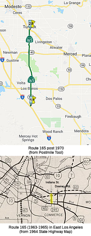
 In 1963, Route 165 was defined as the route from "Route 5 to Route 60 via Indiana Street in Los Angeles County." This was a temporary routing
to connect Route 60 and I-5. In 1965, Chapter 1372 deleted this routing.
In 1963, Route 165 was defined as the route from "Route 5 to Route 60 via Indiana Street in Los Angeles County." This was a temporary routing
to connect Route 60 and I-5. In 1965, Chapter 1372 deleted this routing.
Post-1970 Routing (San Joaquin Valley)
In 1970, Chapter 1473 redefined Route 165 as "Route 5 south of Los
Banos to Route 99 near Turlock.". This routing was previously County Sign Route J14.
By 1975 Route 165 is shown complete from I-5 to Route 140 on the state
highway map. Route 165 was completed from Route 140 to Route 99 sometime
between 1977 and 1979.
(Source: AAroads, Jan 2018)
 Pre 1964 Signage History
1963-1965 Routing (Los Angeles)
The 1964-1965 incarnation of Route 165 was LRN 230. It ran along Indiana Street between I-5 and Route 60. LRN 230 is closely tied to the history of LRN 166, which became Route 245. LRN 166 was created during 1933 as "Los Angeles, Indiana and 3rd Streets to the Huntington Beach-Whittier Road near Santa Fe Springs". In 1935, this was added to the highway code as LRN 166 with the definition:
"[LRN 172], at the intersection of Indiana and Third Streets, in Los Angeles, to [LRN 171] near Sante Fe Springs"
This route, as originally defined, ran down from 3rd St (LRN 172) and Indiana St and then across Telegraph Road (the future I-5 routing) perhaps as far as Buena Park, where it met a routing of Route 39, which was LRN 171. The routing started out as US 101 Bypass, and later became I-5. The Indiana Street portion is what concerns us here.
In 1941, Chapter 142 changed both endpoints of LRN 166, making the route
from "[LRN 172] at the intersection of Downey Road Indiana
and Third Streets, in Los Angeles, to LRN 174 near Norwalk
[LRN 171] near Sante Fe Springs". Downey Road is the
short-lived post-1964 Route 245. This led to a change in LRN 173, which
was adjusted to end at Downey Road instead of Indiana Street. That
change also removed Indiana Street from the state highway system
(briefly). After this change, LRN 166 ran from LRN 172 (3rd
Street, eventual Route 60) at the intersection of Downey Road to former
Route 42 (LRN 174) near Norwalk. This included the segment of 1964-1965
Route 245 along Downey Road between Route 60 (LRN 172) and US 101, and the
segment of US 101 (freeway routing) from Downey Road to LRN 174
(intersection with former Route 42). This was reflective of the creation
of the US 101 Bypass Freeway.
In 1947, Indiana St was added back to the State Highway System, this time
as LRN 230. It ran between Olympic/9th and 3rd. That changed in 1957, when
Chapter 36 changed the terminus of LRN 173: "… to [LRN 166]
near Downey Road [LRN 2] near Soto Street". This change
made Olympic/9th St. between Soto St and Indiana part of LRN 230 (although
no change was needed in the legislative definition). In the 1964
renumbering, LRN 230 along Indiana became short-lived Route 165, LRN 173
became the Santa Monica Freeway, and the US 101 Bypass portion of LRN 166
became I-5 (connecting with the new freeway version of LRN 2).
Post-1970 Routing (San Joaquin Valley)
The post-1970 routing was not a state highway prior to its definition.
Sign Route 165 was not included in the initial set of state signed routes in 1934.
 Status
Roadway Rehabilitation near Wolfsen Road (~ MER 15.093)
There are plans to rehabilitate Wolfsen Road near Stevenson (~ MER 15.093). This project is fully funded in the 2006 State Highway Operations and Protection Program. The total estimated project cost, support and capital, is $25,087,000. Construction is estimated to begin in Fiscal Year (FY) 2009-10.
In July 2010, the CTC approved for future consideration of funding a project that will rehabilitate roadway and replace bridge near the city of Los Baños, specifically between MER PM 11.7 and MER PM 26.9. The project is fully funded in the 2010 State Highway Operation and Protection Program. Construction is estimated to begin in Fiscal Year 2009-10. Total estimated project cost is $25,773,000 for capital and support.
In July 2011, it was reported that Caltrans is initiating a $25.8 million project to lay 15 miles of new asphalt, realign Santa Fe Grade and Wolfsen Road with Route 165, widen the San Joaquin River Overflow and Salt Slough bridges, and replace the San Joaquin River Bridge. This will result in Route 165 being closed for construction (tentatively) between Oct. 3, 2011 and Feb. 3, 2012 from Henry Miller Road to one-tenth of a mile south of Route 140.
In December 2012, the CTC relinquished right of way in the county of Merced along Route 165 at Santa Fe Grade Road, consisting of collateral facilities.
In May 2019, the CTC authorized relinquishment of right of way in the
county of Merced (County) along Route 165 on Westside Boulevard
(10-Mer-165-PM 29.8, 1 segment), consisting of a relocated and
reconstructed county road. The County by resolution dated March 28, 2018,
agreed to waive the 90-day notice requirement and accept title upon
relinquishment by the State.
(Source: May 2019 CTC Minutes, Agenda Item 2.3c)
The 2020 SHOPP, approved in May 2020, included the following New Mobility
item of interest: 10-Merced-140 PM 16.0/16.5 PPNO 3438 Proj ID 1017000175
EA 1H020. Route 140 near Hilmar, at the intersection of Route 140 (PM
16.0/16.5) and Route 165 (PM 26.6/27.1). Install a signal with dedicated
left-turn lanes or construct roundabout. Programmed in FY23-24, with
construction scheduled to start at the end of December 2024. Total project
cost is $9,871K, with $5,200K being capital (const and right of way) and
$4,671K being support (engineering, environmental, etc.).
(Source: 2020 Approved SHOPP a/o May 2020)
In December 2020, the CTC approved vacation of 10-Mer-165-PM
29.8/30.3—Right of way in the county of Merced along Route 165 at
Westside Boulevard, consisting of superseded highway right of way no
longer needed for State highway purposes.
(Source: December 2020 CTC Agenda, Agenda Item
2.3d)
Hilmar Rerouting (~ MER 33.354).
There also appear to be plans for a re-routing near Hilmar (~ MER 33.354). According to the Merced Sun-Star, rerouting the highway -- which now runs down Lander Avenue and directly through the core of Hilmar -- is vital to the area's future, as it has been a very accident prone area. At most, the project will reroute Route 165 from Route 140 in the south to Bradbury Road in the north. As of late 2007, there was a study under way to identify at least two specific proposals for where and how the highway should be moved, in addition to developing an approximate schedule for the project and a cost estimate. The study should completed by early 2009. The $500,000 study was paid for by a federal earmark, a $100,000 donation from local developer JKB Homes and $8,000 contributions from each of the local government agencies involved in the project. The local governments will also be responsible for raising the money to build the new highway.
In 2010, it was reported that the list of potential
routes has been downselected to two preferred routes. Alternatives D2/D4
and I2 would each diverge from the existing Route 165 south of the Merced
River, skirt to the east of Hilmar, and directly connect to Route 99 at
their northern terminus. But their paths differ, with D2/D4 maintaining a
more direct north/south path after a short northeastern jog following the
Merced River. Alternative I2 weaves its way through farmland as it curves
east to meet the Bradbury Road interchange. Both suggested routes are
projected to alleviate problems with the current Route 165 — the
stretch of Lander Avenue that cuts through Hilmar to connect Route 99 and
Route 140. Each new route is expected to reduce traffic congestion, cut
down on accidents, and ease the deleterious impacts of truck traffic on
Hilmar’s downtown businesses — all while improving traffic
circulation for drivers throughout the region. In terms of strengths and
weaknesses, D2/D4 is projected to take a middle-of-the-road approach,
being consistently good in several areas — ranking fourth in
improved access to Route 99, third in local traffic circulation, fourth in
right of way impacts and eighth in goods movement. The I2 alternative,
conversely, split first place finishes in safety, right of way impacts,
and design standards with low showings of eighth in improved access to
Route 99, 16th in traffic circulation and 18th in goods movement. The
community appears to prefer D2/D4. Project scoping, the current phase of
the development, should wrap up in 2010, while the environmental review
process may run through 2014. A final route won’t be selected for
some time yet, and construction is not set to begin until 2017 at the
earliest. No funding has been identified for the process to obtain right
of way, design the highway, or for construction, which preliminary
estimates project could cost $200 million. The large cost comes in part
due to a new bridge over the Merced River, required by both preferred
alternatives. Another large chunk of funding would be needed for a new
interchange with Route 99 in the D2/D4 plan, near the existing Youngstown
Road and W. Harding Road, while in the I2 plan the existing Bradbury Road
interchange would be overhauled.
(Source: Turlock Journal, 4/30/10)
 Naming
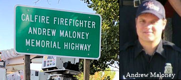 The portion of Route 165 located between Berkeley Drive (approx MER-165-8.137) and
Pioneer Road (approx MER-165-7.779) in the County of Merced, near Los
Banos, is named the "CalFire Firefighter Andrew Maloney Memorial
Highway". It was named in memory of CalFire Firefighter Andrew
Maloney. In the year 2000, Andrew Maloney began his career as a paid call
firefighter for the Merced County Fire Department in Los Banos and he
worked for the United States Fish and Wildlife Service as a firefighter in
the summer of 2001. Maloney worked for CalFire from 2003 until his death
on June 12, 2016, serving at the Los Banos, Santa Nella, and Hornitos
stations. Maloney was also involved in fire safety programs in Merced and
Mariposa Counties. Colleagues described working with Maloney as
“nothing but enjoyable,” noting that even when working outside
in 115° weather in the sun Maloney would always make sure everyone
was smiling. In addition, CalFire said in a statement that “Andrew
will be missed not only by his parents, brother and friends, but also by
his entire Cal Fire and Merced County Fire Department family.”
Maloney enjoyed the outdoors, both in his professional and personal life,
was an avid scuba diver, hiked both the Appalachian and Pacific Crest
trails, loved animals, and was the rare vegetarian firefighter working
amongst carnivores. On June 9, 2016, while riding his motorcycle, Maloney
was hit by a distracted driver who was found to be under the influence of
alcohol and cannabis, and died three days later of his injuries. Named by
Assembly Concurrent Resolution (ACR) 47, 8/30/2017, Res. Chapter 132,
Statutes of 2017.
The portion of Route 165 located between Berkeley Drive (approx MER-165-8.137) and
Pioneer Road (approx MER-165-7.779) in the County of Merced, near Los
Banos, is named the "CalFire Firefighter Andrew Maloney Memorial
Highway". It was named in memory of CalFire Firefighter Andrew
Maloney. In the year 2000, Andrew Maloney began his career as a paid call
firefighter for the Merced County Fire Department in Los Banos and he
worked for the United States Fish and Wildlife Service as a firefighter in
the summer of 2001. Maloney worked for CalFire from 2003 until his death
on June 12, 2016, serving at the Los Banos, Santa Nella, and Hornitos
stations. Maloney was also involved in fire safety programs in Merced and
Mariposa Counties. Colleagues described working with Maloney as
“nothing but enjoyable,” noting that even when working outside
in 115° weather in the sun Maloney would always make sure everyone
was smiling. In addition, CalFire said in a statement that “Andrew
will be missed not only by his parents, brother and friends, but also by
his entire Cal Fire and Merced County Fire Department family.”
Maloney enjoyed the outdoors, both in his professional and personal life,
was an avid scuba diver, hiked both the Appalachian and Pacific Crest
trails, loved animals, and was the rare vegetarian firefighter working
amongst carnivores. On June 9, 2016, while riding his motorcycle, Maloney
was hit by a distracted driver who was found to be under the influence of
alcohol and cannabis, and died three days later of his injuries. Named by
Assembly Concurrent Resolution (ACR) 47, 8/30/2017, Res. Chapter 132,
Statutes of 2017.
(Image Source: Caltrans District 10 Facebook post; Cal Fire News)
 Named Structures
 Bridge 39-0211 (which was replaced by 39-0246, MER 025.60, SAN JOAQUIN RIVER, in 2012; note that 39-0210 at MER
24.82 and 39-0212 at MER 25.77 were both built in 1959), at the San
Joaquin River in Merced County, is named the "George J. Hatfield Bridge".
It was built in 1959. When it was named, Route 165 was a county road
(Lander Avenue). The County Board of Supervisors named the bridge in honor
of George J. Hatfield (October 29, 1887 – November 15, 1953), who
served as U.S. Attorney for the Northern District of California from
1925–33, was the 32nd Lieutenant Governor of California from 1935 to
1939 serving under Governor Frank Merriam. He also represented Madera and
Merced Counties in the State Senate from 1943 until his death. He was the
original sponsor of California's farm and home purchase program for war
veterans. . The George J. Hatfield State Recreation Area in Merced County
is also named in his honor.
Bridge 39-0211 (which was replaced by 39-0246, MER 025.60, SAN JOAQUIN RIVER, in 2012; note that 39-0210 at MER
24.82 and 39-0212 at MER 25.77 were both built in 1959), at the San
Joaquin River in Merced County, is named the "George J. Hatfield Bridge".
It was built in 1959. When it was named, Route 165 was a county road
(Lander Avenue). The County Board of Supervisors named the bridge in honor
of George J. Hatfield (October 29, 1887 – November 15, 1953), who
served as U.S. Attorney for the Northern District of California from
1925–33, was the 32nd Lieutenant Governor of California from 1935 to
1939 serving under Governor Frank Merriam. He also represented Madera and
Merced Counties in the State Senate from 1943 until his death. He was the
original sponsor of California's farm and home purchase program for war
veterans. . The George J. Hatfield State Recreation Area in Merced County
is also named in his honor.
(Image source: Geni)
 Other WWW Links
 Statistics
Overall statistics for Route 165:
 Pre-1964 Legislative Route
In 1933, Chapter 767 defined the route from "San Pedro to [LRN 9] near La Canada via Figueroa Street" as part of the state highway system. In 1935, this was added to thie highway code as LRN 165, with the routing:
"San Pedro to [LRN 9] near La Canada via Figueroa Street"
Scott Parker on AARoads noted the following regarding the early routings
of LRN 165/Route 11:
(Scott Parker (Sparker) on AARoads, "Re: US 66 1935 alignment via Eagle Rock pre-1936 via Royal Oaks Ave in Monrovia?", 5/21/2019)
It certainly seems that pre-'34-35 the Division of Highways was in the process of "trying out" various street alignments before settling on any particular one for its urban LRN's; LRN 165 was no exception. Through downtown L.A., it was pretty much a certainty -- due to the topology -- that any N-S thoroughfares would be either at Broadway or east or west along what is now Figueroa to avoid the interim hill. And given the desire to avoid the commercial downtown area (the 7th street alignment of US 101 didn't last long at all!), skirting it on Figueroa, which was well west of the main retail zone, was probably a consensus choice for that particular N-S highway alignment. But the problem there was the Elysian Park hill area; prior to the series of tunnels that opened in '35, everything had to go around the hills to the southeast. So LRN 165 could get up to Sunset on Figueroa, but for a couple of years no farther than that using that trajectory. For the first couple years of its existence, LRN 165 (aka Route 11 and, north of US 101, US 66) "jogged" south along US 101 to Broadway, turned NE, and followed it to Pasadena Ave., which intersected it right on its L.A. River bridge. From there it paralleled Broadway a couple of blocks north of that arterial to the intersection with Avenue 26 and Daly St. (LRN 4), where it turned NNE, crossed Arroyo Seco, and reached Highland Park, where it skirted the south side of Mt. Washington on what is now North Figueroa to York Blvd. A street, Garvanza Ave., extended north from there to Colorado Blvd. in the eastern portion of Eagle Rock; that later became the northernmost part of Figueroa St., with the whole thing being incorporated into LRN 165. Route 11 -- and after 1934, US 66 -- turned east on Colorado St (LRN 161, which was Route 134 west of Garvanza/Figueroa) to the anchorage of the famous/infamous "Suicide Bridge" multiple-arch high bridge over Arroyo Seco, where LRN 165 and Route 11 diverged north onto Linda Vista Ave. heading toward La Canada/Flintridge.; LRN 161/US 66 went east across the bridge into downtown Pasadena. Prior to 1934, when Garvanza was widened to 4 lanes, US 66 took a temporary non-state-highway detour -- the last iteration of ACSC-signed US 66 -- east on York Blvd back across Arroyo Seco, segueing onto South Pasadena's "Pasadena Ave." east to Fair Oaks, where it turned north into Pasadena itself. But once the tunnels under Elysian Park were completed, the entire street was renamed North Figueroa and LRN 165 rerouted over its length.
Later that year, Chapter 274 amended the definition to add routing information: "…via Figueroa Street and Linda Vista Avenue"
In the mid 1930s, the routing from Pasadena to Los Angeles was in flux. A 1935 map, based on a 1934 survey, shows that LRN 165 may have run along Avenue 64, York Avenue, Figueroa, Riverside Drive, Figueroa, Solano Avenue to Broadway, and then back to Figueroa. Some earlier maps seems to show a routing along Fair Oaks and Pasadena Avenue (as Scott Parker noted), and some even show a routing down Pasadena Ave from Figueroa to Broadway. It does seem clear that once the Figueroa Tunnels opened, LRN 165 was routed along Figueroa.
In 1947, Chapter 1233 simplified the definition to drop any specific routing.This was the route from San Pedro to US 66 (eventually I-210) near La Cañada. Portions of this were Route 11. It was signed as Route 11; it was also signed as US 6 between San Pedro and downtown Los Angeles; as cosigned US 6/US 66 between US 101 and US 99. It was signed as US 66 between US 101 and Colorado Blvd in Pasadena. Portions N of US 99 were Route 159. This was later resigned as present-day Route 110 and I-110. It originally ran along Figueroa and Linda Vista.
© 1996-2020 Daniel P. Faigin.
Maintained by: Daniel P. Faigin
<webmaster@cahighways.org>.
 From Route
  Route 164
 Route 166