
 California Highways:
Click here for a key to the symbols used. An explanation of acronyms may be found at the bottom of the page.
 Routing
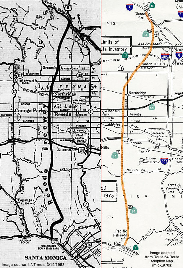 From Route 1 north of the intersection of Sunset Boulevard northwest of Santa
Monica to Route 5 near Tunnel Station.
From Route 1 north of the intersection of Sunset Boulevard northwest of Santa
Monica to Route 5 near Tunnel Station.
 Post 1964 Signage History
In 1963, this segment was defined as "(a) Route 1 northwest of Santa Monica to Route 5 near Tunnel Station." Note that this definition appears to be closer to the 1973 Route 64 adoption map terminus with Route 1, which is S of Sunset Blvd.
In 1965, Chapter 2007 changed this to read "(a) Route 1 north of the intersection of Sunset Boulevard northwest of Santa Monica to Route 5 near Tunnel Station."
 Pre 1964 Signage History
 In March 1958, the LA Times reported that the LA City Engineer was recommending to the State Legislature construction of a $75,000,000
freeway from US 6 N of Sylmar to the Pacific Coast. The project was
approved by the Metropolitan Transportation Board for consideration by the
1959 Legislature. According to Lyall Pardee, the City Engineer, much of
the right of way for the "Reseda-to-the-Sea" highway had been acquired.
There were some proposals that this be constructed as a toll road. An
article in the Los Angeles Evening Citizen News dated May 14, 1962, the
route would start in Tarzana at the junction of the Ventura Freeway (US 101), run through the Santa Monica Mountains and empty into an area about
½ mi N of Sunset Blvd or around the Brentwood or Pacific Palisades
area. That article indicated it would connect to the Beverly Hills Freeway
(US 66, Sign Route 2 at the time) and then proceed to the sea, but that
does not work as the Beverly Hills Freeway was never planned to go further
west than I-405.
In March 1958, the LA Times reported that the LA City Engineer was recommending to the State Legislature construction of a $75,000,000
freeway from US 6 N of Sylmar to the Pacific Coast. The project was
approved by the Metropolitan Transportation Board for consideration by the
1959 Legislature. According to Lyall Pardee, the City Engineer, much of
the right of way for the "Reseda-to-the-Sea" highway had been acquired.
There were some proposals that this be constructed as a toll road. An
article in the Los Angeles Evening Citizen News dated May 14, 1962, the
route would start in Tarzana at the junction of the Ventura Freeway (US 101), run through the Santa Monica Mountains and empty into an area about
½ mi N of Sunset Blvd or around the Brentwood or Pacific Palisades
area. That article indicated it would connect to the Beverly Hills Freeway
(US 66, Sign Route 2 at the time) and then proceed to the sea, but that
does not work as the Beverly Hills Freeway was never planned to go further
west than I-405.
(Source: As indicated, via email from Will Poundstone, 1/1/2024)
By 1963, this segment was LRN 290. It was defined in 1959, but was never constructed.
 Status
The 2013 Traversable Highways report notes:
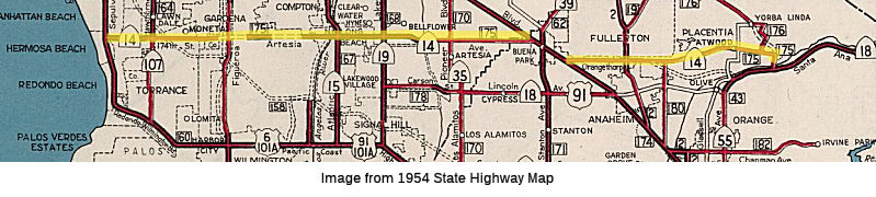
 In 1934, Sign Route 14
was signed along the route from Hermosa Beach to Jct. Sign Route 18 near
Olive, via Artesia Ave. Specifically, this routing ran from LRN 43 (Route 18, US 91,present day Route 91 near Yorba Linda) to Sign Route 3, later US 101A, in Hermosa Beach, along Imperial Highway, Orangethorpe Avenue, Grand
Avenue, Artesia Blvd, 174th Street, Redondo Beach Blvd, and
Gould Avenue. It ended at Gould Avenue and Sepulveda Blvd, at the junction
with US 101A. The routing was LRN 175, and was added to the state highway
system in 1933.
In 1934, Sign Route 14
was signed along the route from Hermosa Beach to Jct. Sign Route 18 near
Olive, via Artesia Ave. Specifically, this routing ran from LRN 43 (Route 18, US 91,present day Route 91 near Yorba Linda) to Sign Route 3, later US 101A, in Hermosa Beach, along Imperial Highway, Orangethorpe Avenue, Grand
Avenue, Artesia Blvd, 174th Street, Redondo Beach Blvd, and
Gould Avenue. It ended at Gould Avenue and Sepulveda Blvd, at the junction
with US 101A. The routing was LRN 175, and was added to the state highway
system in 1933.
In 1935, the highway began eastbound at Sign Route 3/LRN 60 near Hermosa
Beach via Aviation Boulevard, Redondo Beach Boulevard and 174th
Street. There was a gap in the highway beginning at Normandie Avenue
near the Los Angeles city limit to the Pacific Electric Railway south of
Compton. From the Pacific Electric Railway, the highway followed
Artesia Boulevard east to the Orange County line. Within Orange
County, eastbound Sign Route 14/LRN 175 followed Artesia Boulevard, Sign
Route 39/LRN 62 on Grand Avenue, Orangethorpe Avenue and the Yorba Bridge
over the Santa Ana River to Sign Route 18/LRN 43. By 1936, the
western terminus of Sign Route 14/LRN 175 was realigned onto Redondo Beach
Boulevard.
(Source: Gribblenation Blog (Tom Fearer), "California State Route 14 (i)", 10/10/2023)
In 1937, the final segment of the "Manchester Boulevard Extension" opened
(dedicated on April 30, 1937). The Manchester Boulevard Extension
provided a direct link between Downey and Anaheim that followed the
Southern Pacific Railroad. The Manchester Boulevard Extension
bypassed downtown Anaheim and tied into existing alignment of Sign Route 10/LRN 174 on southern Manchester Boulevard at Miraflores near the
outskirts of Santa Ana. The Manchester Boulevard Extension was
conceived during 1924 by the Greater Manchester Avenue Improvement
Association. The Manchester Boulevard Extension concept was taken
over by the Division of Highways when LRN 174 was added as a State Highway
circa 1933. Sign Route 14 was realigned onto a multiplex of SIgn
Route 10 on the Manchester Boulevard Extension between Artesia Boulevard
and Orangethorpe Avenue.
(Source: Gribblenation Blog (Tom Fearer), "California State Route 14 (i)", 10/10/2023)
In 1939, construction funds were budgeted for 5 miles of Sign Route 14/LRN 175 east of Normandie Avenue
(Source: Gribblenation Blog (Tom Fearer), "California State Route 14 (i)", 10/10/2023)
On July 1, 1947, the AASHO Executive Secretary notified the California
State Highway Engineer that California's request to extend US 91 from
Barstow to Long Beach had been approved. The extension of US 91 to
Long Beach initially brought it through Anaheim along Center Street via a
multiplex of Sign Route 18/LRN 178. In 1953, work was commenced to
standardize Sign Route 14/LRN 175 along Artesia Boulevard over a 6.25-mile
corridor. This widened the highway to four lane standards and
incorporated the existing Los Angeles River Bridge. The segment of
highway between Alameda Street to Central Avenue was to include three
bridges over the Pacific Electric Railway. By 1955, the entirety of Sign
Route 14/LRN 175 from Normandie Avenue had been adopted by the California
Highway Commission as the planned "Artesia Freeway."
(Source: Gribblenation Blog (Tom Fearer), "California State Route 14 (i)", 10/10/2023)
By 1955, US 101 along the Santa Aana Freeway between 1st
Street and Browning Avenue near Santa Ana/Tustin was 70% complete.
The LRN 175 (Sign Route 14) Freeway was referenced locally as the
"Orangethorpe Freeway" and approximately 50% complete. The planned
LRN 175 Freeway west of US 101 was referenced as the "Artesia Freeway" and
"Hermosa Beach Freeway." By 1956, US 91 and Sign Route 18 were realigned
onto Sign Route 14/LRN 175 north of downtown Anaheim. The interim
routing of US 91/Sign Route 18 from Lincoln Avenue followed US 101/Manchester Boulevard, Orangethorpe Avenue, Cypress Avenue (now State
College Boulevard) and a completed segment of the Orangethorpe Freeway
(east of LRN 180).
(Source: Gribblenation Blog (Tom Fearer), "California State Route 14 (i)", 10/10/2023)
By 1957, Sign Route 18 and US 91 were realigned onto the Stanton Avenue
Extension along Sign Route 39/LRN 171 in Buena Park. Both highways
briefly multiplexed US 101 towards Sign Route 14/LRN 175 on Orangethorpe
Boulevard.
(Source: Gribblenation Blog (Tom Fearer), "California State Route 14 (i)", 10/10/2023)
By 1959, the eastern end of the route had shifted S to near Jefferson St. in preparation for the new Route 91 Freeway routing. With the completion of the Riverside Freeway between I-5/US 101 (the Santa Ana Freeway) and Cypress Street, Route 14 was cut back to begin at Cypress Street at then US 91/Route 18, 4 miles west of the Route 55/US 91 junction in Placentia. The multiplex of Route 14 with I-5 and US 101 through Buena Park was still present.
By the late 1950s, it was cosigned as Route 14/US 91 between the US 91/Route 55 junction and and the Orangethorpe/US 101 (I-5) junction (although at one point, it was pre-1964 Route 18 that was US 91). In general, US 91 ran along as much of the Riverside Freeway as was constructed, and then took the next N/S lateral down to Lincoln -- be that State College (Placentia), Brookhurst St, or Byp US 101.
In 1962, Sign Route 18 was truncated from Long Beach
to San Bernardino. The truncation of Sign Route 18 removed it from
US 91/Sign Route 14/LRN 175 on the Riverside Freeway north of downtown
Anaheim. US 91 was requested by the Division of Highways to be
truncated to Barstow during 1963. The truncation of US 91 to Barstow
appears in a letter written by the State Highway Engineer to the AASHO
Executive Secretary dated August 26, 1963.
(Source: Gribblenation Blog (Tom Fearer), "California State Route 14 (i)", 10/10/2023)
Route 14 was renumbered as Route 91 on July 1, 1964. This routing is longer than the 1935 routing, which only went E as far as Artesia and Firestone, where it joined what was then numbered as Route 10. The 1935 routing also had a discontinuity between Normandie Ave and Alameda St, where Artesia Blvd did not cross. Until Artesia was complete between Hawthorne and Alameda, the routing used a detour than ran N on Alameda to Compton, W on Compton, a S job at Avalon, then W across Redondo Beach Blvd to Hawthorne Blvd.
The 1964 Highway Renumbering also defined the
segment of former US 91 and Sign Route 18 from Sign Route 19 to I-5 as
Route 214. 1965 Legislative Chapter 1372 added a stipulation to the
definition of Route 214: "This route shall cease to be a state highway
when Route 91 freeway is completed from Route 19 to Route 5 and the
commission relinquishes that portion of present Route 91 from Route 19 to
Route 5." Route 214 was deleted in 1981.
(Source: Gribblenation Blog (Tom Fearer), "California State Route 14 (i)", 10/10/2023)
Status Unconstructed (22 miles). There is no documented traversable local routing between US 101 and Route 1, although you can read the plans
below (and note that as of 1953, Reseda Blvd actually was shown as
intersecting Sunset near Will Rogers Park along Rustic Canyon, although it
didn't make it all the way over the hills). The traversable local routing
between US 101 and Route 118 is Reseda Blvd. There is no traversable local
routing between Route 118 and I-5. There are no plans for improvement.
The freeway and expressway system plans, both in the mid 1950's and 1960's, were that this route would be constructed to freeway standards down Reseda Blvd and across the Santa Monica Mountains to intersect with the Pacific Coast Freeway, Route 1. Currently, the only clue of this plan is that the milepost for Route 14 does not go to 0.00 at the I-5 junction.
It is interesting to note that, at one time, Reseda (at least on paper) continued to Sunset Blvd (although not continguously), meeting Sunset at what is now Sullivan Canyon Road.
The cross mountain roadway was first proposed in the early 1920s. By 1928, various San Fernando Valley Chambers of Commerce were showing a potential "Reseda to the Sea", that meandered through Temescal Canyon to Pacific Coast Highway. The road continued to be proposed through the 1930s and 1940s as a vital 25-mile roadway. By the 1950s, it was listed as a potential freeway, as evidenced by its definition as LRN 290.
It became controversial in the 1960s. San Fernando Valley leaders, in the 1960s, persuaded the Los Angeles City Council to study the feasibility of building it as a toll road, but that never happened.
It should be noted that the intersection of Temescal Canyon Road and Pacific Coast Highway was designed large enough to handle traffic at the beach end, but the construction of Palisades High School in 1961 scuttled that route. However, the planning maps make it clear that Temescal and Pacific Coast Highway was the intended terminus (creating difficulty with the "north of Sunset" in the definition).
Opposition to the route grew in the 1970s and 1980s. In 1998, Los Angeles gave up the city's easement between Winford and Mulholland drives in Tarzana. However, the route still shows up on a few city maps. The fact that this will never be constructed is reflected in the exit numbers on the Route 14 freeway segment, which go to 0 at I-5.
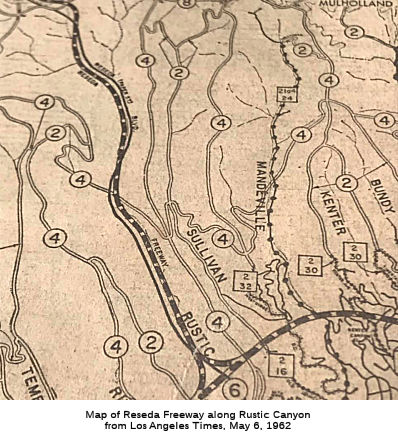 The unconstructed segment left I-5 around Balboa Blvd. It
crossed Route 118 just W of Balboa, and then continued W until
approximately Lassen and Wilbur, at which time it ran due S along Wilbur,
crossing Mullholland, intersecting Sunset at Temescal Canyon, and
continuing down the Canyon to Route 1. One map published in the Los
Angeles Times showed the route running a bit to the E of Temescal, meeting
Sunset at Rustic Canyon closer to Will Rodgers Park. That correlates with
some maps that show Reseda Blvd crossing over the hills into Will Rodgers
Park. Such a crossing would have intersected PCH closer to Entrada Dr.
than Temescal.
The unconstructed segment left I-5 around Balboa Blvd. It
crossed Route 118 just W of Balboa, and then continued W until
approximately Lassen and Wilbur, at which time it ran due S along Wilbur,
crossing Mullholland, intersecting Sunset at Temescal Canyon, and
continuing down the Canyon to Route 1. One map published in the Los
Angeles Times showed the route running a bit to the E of Temescal, meeting
Sunset at Rustic Canyon closer to Will Rodgers Park. That correlates with
some maps that show Reseda Blvd crossing over the hills into Will Rodgers
Park. Such a crossing would have intersected PCH closer to Entrada Dr.
than Temescal.
(Source: Rustic Canyon info and map from a FB post by Anthony Pearson, 4/14/2019)
Michael Ballard noted that there is some grading as well as some concrete (though no longer really visible as a "stub") from the planned extension of Route 14 at the Route 14/I-5 interchange. Pre-1971 earthquake plans do show the routing of the unbuilt ramps for Route 14 South (which would have had the control city of "Beach Cities"). Michael has added information on this interchange to his site at http://socalregion.com/highways/la_highways/golden_antelope_interchange/; the following is excerpted and summarized therefrom (consult the link for interchange drawings and additional details):
In the mid-1960s, the original design was done for the main interchange between I-5 and Route 14. This interchange not only supported the current Route 14 "Antelope Valley" Freeway; it allowed for the future extension of Route 14 south of I-5 (the "Reseda Freeway"). This extension would have eventually carried Route 14 through the San Fernando Valley to Route 1 near Temescal Canyon Road. Through the pass area, the Reseda Freeway would have paralleled I-5 from the current Route 14 junction to about Balboa Blvd. From there, the route was never precisely determined (but would roughly, as the name suggests, have gone over to Reseda somehow and down). Construction on the new interchange began in 1969. This was to be a major project: including the south end of the Antelope Valley Freeway, the realignment of the Golden State Freeway, and the reconstruction of the former freeway. There was to be massive grading and extensive cuts. The support for SB Route 14 was implemented in the design. Signage showed the somewhat unique signage that was to be applied to the full interchange. Route 14 South was to have the control point of “Beach Cities”, where Route 14 North had “Palmdale”. There was to be a short connector ramp between the Route 14 SB Truck Connector and the mainline Route 14 SB to I-5 NB Connector ramp, as part of the southern Route 14 extension. It was not built but the bridges were built to accommodate it. Then the 1971 Sylmar quake occurred. Some of the tallest columns, forming the supports for the I-5 SB to Route 14 NB connector, collapsed during the quake. Changes were made to the freeway plans after the earthquake. Signage for Route 14 South was eliminated as well as the short connector near the Sierra Highway Undercrossing for I-5 South and Route 14. These changes in the design plans seem to show that, should the Reseda Freeway be built, it wouldn’t be for quite some time. Despite that, the interchange that was finally constructed did leave room for that freeway. Construction, or reconstruction in this case, was finally completed in 1975. After the 1994 earthquake when the SB Route 14 to SB I-5 connector bridge collapsed again, most of the evidence for the connection to this segment of Route 14 disappeared. All that remains are some stub ramps, such as the I-5 SB to Route 14 (Reseda Freeway) and the truck connector from Route 14 SB to I-5 NB are still visible. Michael's site has some photos showing these stubs in detail.
(Source: Southern California Regional Rocks and Roads, "Golden State Freeway / Antelope Valley Freeway Interchange")
 Naming
 This segment would have been named the "Reseda Freeway". This is because the
freeway would have traversed the community of Reseda in the City of Los
Angeles. Reseda is the name for any plant of the European genus Reseda,
including mignonette and dyer’s rocket, which has small spikes of
greenish, yellowish or whitish flowers. The community of Reseda originated
in 1912 as the town of Marian. It was named after Marian Otis Chandler,
the daughter of Los Angeles Times publisher Harrison Gray Otis and wife of
Harry Chandler. The geographic name "Reseda" was first used for a siding
on a branch of the Southern Pacific Railroad, which ran between the cities
of Burbank and Chatsworth in the San Fernando Valley. In the 1920s, the
name was transferred from the Southern Pacific Railroad to the Western
Division of the Pacific Electric Railway "Red Cars Line", which had
expedited development after the building of the Los Angeles Aqueduct.
Later, it was used as the name of a stop on the Pacific Electric
interurban railway along Sherman Way. In 1921, when a Fourth Class Post
Office was found to be necessary, the town's name had to be changed.
Ninety-two residents convened and agreed to rename the town Reseda.
This segment would have been named the "Reseda Freeway". This is because the
freeway would have traversed the community of Reseda in the City of Los
Angeles. Reseda is the name for any plant of the European genus Reseda,
including mignonette and dyer’s rocket, which has small spikes of
greenish, yellowish or whitish flowers. The community of Reseda originated
in 1912 as the town of Marian. It was named after Marian Otis Chandler,
the daughter of Los Angeles Times publisher Harrison Gray Otis and wife of
Harry Chandler. The geographic name "Reseda" was first used for a siding
on a branch of the Southern Pacific Railroad, which ran between the cities
of Burbank and Chatsworth in the San Fernando Valley. In the 1920s, the
name was transferred from the Southern Pacific Railroad to the Western
Division of the Pacific Electric Railway "Red Cars Line", which had
expedited development after the building of the Los Angeles Aqueduct.
Later, it was used as the name of a stop on the Pacific Electric
interurban railway along Sherman Way. In 1921, when a Fourth Class Post
Office was found to be necessary, the town's name had to be changed.
Ninety-two residents convened and agreed to rename the town Reseda.
(Naming information on Reseda: Wikipedia; Image source: Los Angeles Times, 11/5/1961 via Joel Windmiller,
1/18/2023)
 From Route 5 at Los Angeles near Tunnel Station to Route 58.
Note: Section 314.1 also states:
(a) The commission may relinquish to the City of Santa Clarita all or any portion of Sierra Highway, also known as Route 14U, located within the city limits of that city, upon terms and conditions the commission finds to be in the best interests of the state, if the department and the city enter into an agreement providing for that relinquishment.
(b) A relinquishment under this section shall become effective immediately after the county recorder’s recordation of the relinquishment resolution containing the commission’s approval of the terms and conditions of the relinquishment.
(c) On and after the effective date of the relinquishment, both of the following shall occur:
Post 1964 Signage HistoryThis segment is as defined in 1963. Note that the freeway version of the route was never signed as US 6.
In October 1966, a six mile section of Route 14 between the Angeles
Forest Highway and Avenue P-8 in Palmdale opened. Construction cost was
$5.4 million.
(Source: CHPW, Jan/Feb 1967)
Pre 1964 Signage History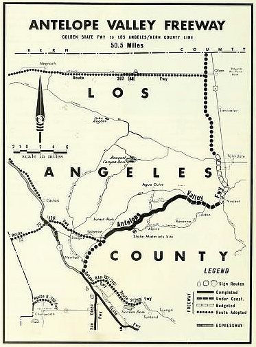 Circa 1935, this portion of the route was numbered as Route 7. When state routes began to be shielded
as US highways, this was resigned as US 6.
Circa 1935, this portion of the route was numbered as Route 7. When state routes began to be shielded
as US highways, this was resigned as US 6.
The segment between Route 5 near Tunnel Station (former US 99) and Route 126 near Solemint was originally LRN 4, defined in 1910. In 1935, this segment was renumbered as an extension of LRN 23. The remainder of the segment (to Route 58) was part of the 1911 definition of LRN 23.
On March 21, 1956, the Highway Comission adopted the segment of Route 14 (LRN 23) from 1/2 mi N of the junction with Angeles Forest Highway near the SP Railroad Vincent Y to Neeach Road as a freeway. This was locally called the "Palmdale-Lancaster Freeway". On June 21, 1955, the Highway Commission declared existing LRN 23 (future Route 14, US 6) between US 99 and Solemint to be a freeway. The Caltrans planning map to the right shows the route as of 1964.
Here is some history of Route 14, courtesy of a misc.transport.road posting from Michael Ballard.
The original non-freeway routing, Sierra Highway, was a four-lane divided highway its junction with US 99 at Tunnel Station to San Fernando Road. From there to Soledad Canyon Road, it was a three-lane highway (until 1968, then four lane divided). North of Solemint Junction (Soledad Canyon Road) to Palmdale it was two-lanes. Palmdale to Lancaster - Four lanes undivided. North of Lancaster to Mojave, two-lanes.
The Antelope Valley Freeway was built in stages on a new alignment. The first was from 1/2 mi E of Solemint Junction to Red Rover Mine Road in 1963. In 1965, the freeway was constructed from Red Rover Mine Road (Ward Road OC) to Pearblossom Highway; and in 1966 from Pearblossom Highway to Ave P-8 (with a temporary connection to Sierra Highway). In 1968, the route was extended from near Ave H to about 1 mile N of Rosamond. The segment from Ave P-8 to Ave H opened in 1972 or 1970.
In 1972, the freeway was constructed from North of Rosamond to Mojave, with the full freeway ending at Silver Queen Road. Also in 1972, the route was constructed from South of Solemint Junction to San Fernando Road. Between 1973 and 1975, the remaning portion from San Fernando Road to I-5 (quake delayed) was opened.
Route 14U (007-LA-14U 24.3/24.577, T27.000/29.848)
There are portions of the route, off-freeway, that are signed as Route 14U. Route 14U is there because of a maintenance-intensive section of Sierra Highway from Placerita Canyon Road to Golden Valley Road that has been a problem since 1938. As a result, the County doesn't want the roadway, nor does the City of Santa Clarita, so it remains in State hands. Michael Ballard has posted information and photos on his Route 14U page. In September 2017, AB 1172, Chapter 351, Chaptered 9/28/2017, authorized relinquishment of this Route 14U segment to the city of Santa Clarita. This segment is identified in the bill as "the portion of Sierra Highway approximately between the intersection of Newhall Avenue and the intersection of Friendly Valley Parkway within the city limits of the city". (Note that these discussions do not relate to the 14U section between I-5 along Sierra Highway, PM 007-LA-14U 24.3/24.577)
In August 2018, it was reported that maintenance work
had begun on Route 14U, in preparation for Caltrans to turn over the route
to the city. Talks for this transfer have been ongoing since Gov. Jerry
Brown signed AB 1172 into law in September 2017. Before the city can take
over the roadway, the city requires the portion of the roadway be brought
up to city standards, including improving the road’s grading, slope
and environmental factors. The Fall 2018 roadwork includes a $2.4 million
Caltrans road repair project that will include dig-outs, road resurfacing
and striping set for multiple locations, including on the road that the
city is discussing with Caltrans. Other areas include sections of Newhall
Avenue to Dockweiler Drive, Dockweiler Drive to Placerita Canyon Road and
Golden Valley Road.
(Source: SCV Signal, 8/20/2018)
There is a detailed history of the Route 14U segment in the Gribblenation Blog post "California State Route 14U (former US Route 6 on Sierra Highway)".
StatusConstructed to freeway standards. The first segment opened in 1963; the last segment opened in 1974.
I-5 to Palmdale (Pearblossom Highway) (~ LA R25.019 to LA R54.536)
Construction should start in winter 2008 on a $156 million project to elevate a two-lane car-pool lane to connect car-pool lanes on I-5 and Route 14. The project should be done by 2012. The project appears to have gone to bid in November 2007, with an estimate of $120M for the connectors in Los Angeles County (Santa Clarita) on I-5 from 0.2 Km South of the Balboa Boulevard overcrossing to 0.9 Km South of Weldon Canyon and on Route 14 from the I-5/Route 14 separation (~ LA R25.019) to 2.0 Km North of the Sierra Highway undercrossing (~ LA R25.419).
In March 2013, the CTC relinquished right of way in the city of Santa Clarita along Route 14 at Newhall Avenue (~ LA R27.056), consisting of collateral facilities.
In August 2011, the CTC approved $46,000,000 in SHOPP funding for repairs in and near Santa Clarita, from north of the Santa Clara River Bridge (LA R031.88) to north of Sierra Highway (~ LA R052.17), that will rehabilitate 120 lane miles of pavement to improve safety and ride quality. Project will replace damaged roadway slabs, place dowel bars between new and old slabs, replace approach and departure slabs at structures, grind and overlay auxiliary lane, place concrete termini at eight ramps, replace guardrail, grind and groove pavement, and seal joints and cracks.
Route 14U - Sierra Highway
Note that Route 14U runs along Sierra Highway. There is a portion near the 5/14 interchange (at RM T24.30, the Sierra Highway OC and the N5TRK-N14 Connector to LA 24.577), and another portion from Dockweiler Dr (T27.0) to a point W of Rainbow Glen Dr, roughly at the point of Oakspur Dr. (~ 07-LA-14U 29.848)
Another unrelinquished portion was relinquished in September 2002 (near PM T26.8); this is the segment that was related to the Route 126 and Route 14 junction.
In September 2017, AB 1172, Chapter 351, Chaptered 9/28/2017, authorized relinquishment of the Route 14U segment to the city of Santa Clarita. This segment is identified in the bill as "the portion of Sierra Highway approximately between the intersection of Newhall Avenue (~ R26.0) and the intersection of Friendly Valley Parkway within the city limits of the city" (~ LA 29.848). This segment has not yet been relinquished as of 2022.
In August 2022, it was reported that the Metro board approved a motion
that directed Metro staff to work with Caltrans “to correct
sub-standard configurations” on Route 14 in North L.A. County. The
motion called for acting on recommendations in the 2004 North County
Combined Highway Corridors Study. That study called for increased transit,
multiple reversible high-occupancy lanes, and lots of “substantially
increased vehicle capacity.” It calls for Route 14
“short-range improvements” to include “elimination of
lane drops with continuous 3 mixed-flow lanes and one HOV lane in each
direction between Sand Canyon and Avenue P.” The distance from Sand
Canyon to Avenue P is about 25 miles. The lane configuration there varies;
most of it is six lanes wide, with some seven and eight lane stretches.
Caltrans had indicated its plans to initiate a “capacity
improvements” project on about thirteen miles of Route 14 (between
Newhall Avenue and Agua Dulce Canyon Road) in 2022. About seven miles of
that overlap with the short-range Route 14 widening in the 2004 report.
The status of that overlapping project is unclear; it does not appear on
the Caltrans District 7 current projects listing nor the California
Environmental Quality Act (CEQA) database. The motion directed Metro staff
to get environmental clearance underway for three substandard locations on
Route 14, utilizing $4.7 million in funding from the North County
Transportation Coalition.
(Source: Streetsblog LA, 8/30/2022)
Palmdale (Pearblossom Highway) to Mojave (Route 58) (~ LA R54.536 to KER 18.983)
In August 2011, the CTC approved $13,000,000 in SHOPP funding for repairs in and near Palmdale, from north of Sierra Highway (~ LA R052.17) to Rayburn Road (~ LA R59.152), that will rehabilitate 37 lane miles of pavement to improve safety and ride quality.
In February 2020, it was reported that a nearly 16-month construction
project to improve traffic flow has been completed. The southbound freeway
was widened to add a continuous lane beginning about where it crosses
Technology Drive (Avenue P-8, LA R60.698) and extending nearly to the
Palmdale Boulevard exit (~LA R59.877), removing the bottleneck that can
occur where the road narrows by one lane. In addition, the off-ramp from
the northbound freeway at Rancho Vista Boulevard was widened to
accommodate more vehicles for left- and right-turning traffic. This is
intended to eliminate the back-up of vehicles onto the freeway traffic
lanes. The $25 million project was designed by Caltrans and construction
was completed by contractor C.A. Ras-mus-sen, under the oversight of
Palmdale officials. Construction and design costs were $15.2 million. The
savings from this project will be reallocated to other Measure R projects,
officials said.
(Source: AV Press, 2/19/2020)
In December 2011, the CTC approved $350K to install 9.3 miles of metal beam guardrail to reduce the number and severity of collisions in Palmdale and Lancaster from north of Palmdale Boulevard (~ LA R59.84) to north of Avenue I (~ LA R68.975).
Avenue J Interchange (~ 07-LA-14 PM R68.016)
In March 2023, it was reported that Granite
Construction was selected by the City of Lancaster to lead an
approximately $30 million contract for various improvements to the Avenue
J (Ave J) Interchange at Route 14 (~ LA R68.016). The project will be
funded by Caltrans, the City of Lancaster, and the Los Angeles County
Metropolitan Transportation Authority (LA Metro) and be included in
Granite’s first quarter CAP 2023. The project scope consists of
widening the existing northside on- and off-ramps, constructing new on-
and off-ramps on the south side of Ave J, and building four new retaining
walls. Additionally, the project will involve landscape beautification.
Upon completion, the new northbound off-ramp and the southbound on-ramp to
Route 14 will provide an additional access point to the highway, improving
safety by relieving congestion on Route 14 and providing increased
usability for Ave J. The project is scheduled to start in Spring 2023 and
is expected to be completed by Spring 2024.
(Source: Business Wire, 3/7/2023)
In August 2023, it was reported that construction had
begun to expand the Avenue J interchange at the Antelope Valley
Freeway/Route 14. The $28.8 million project includes widening the
existing northbound on- and off-ramps. There will also be four new
retaining walls and new on- and off-ramps on the south side of Avenue J.
The project will be funded with Measure R funds by the city of Lancaster,
Caltrans and the Los Angeles Metropolitan Transportation Authority.
Lancaster received $65 million in Measure R funds about 11 years ago
to make major upgrades to the highway interchanges at avenues G, J, K and
L and Columbia Way (Avenue M) over the next four years to improve traffic
flow and safety. The project will take 360 days to complete. The Avenue J
northbound and southbound on- and off-ramps will be closed during
construction.
(Source: Antelope Valley Press, 8/1/2023)
In June 2013, it was reported that interchange improvements with Avenue I
(~ LA R68.975) were completed in Lancaster. A collaborative effort between
the Los Angeles County Metro, the City of Lancaster, and Caltrans, the $12
million project involved the widening of Avenue I to three lanes in each
direction, while providing dual left turn lanes onto Route 14 from both
the eastbound and westbound directions. The project also replaced the
problematic stop-sign controlled southbound off ramp with a new loop ramp
which now intersects with Avenue I at 23rd Street West.
(Source: BusinessWire, 3/7/2023)
The 2022 SHOPP included the following new project: 07-LA-14 R71.0. PPNO
5728; ProjID 0720000106; EA 37010. Route 14 Near Lancaster, at Avenue G
Overcrossing Bridge № 53-1860. Financial Contribution Only
(FCO) to city of Lancaster to replace bridge. Total Project Cost: $2,000K.
(Source: “2022 State Highway Operation
And Protection Program, Fiscal Years 2022-23 through 2025-26”,
March 17, 2022)
In September 2016, it was reported by Gary Richards (but echoing a
response from Joe Rouse) that all the green paddle mile markers that had
once been on Route 58 and Route 14 have been removed. According to Joe,
Caltrans HQ Traffic Ops was approached by staff in District 9 about
removing the milepost markets, for the reasons that created confusion when
it came to responding to roadway incidents (for the CHP, Caltrans and
local law enforcement continue to use postmiles to locate roadway
incidents). Because mileposts are not a requirement in the California
MUTCD, Caltrans concurred with their request. The green mile markers were
located on the freeway portions of Route 58 from roughly Tehachapi to the
San Bernardino County line and on the freeway portions of Route 14 in Kern
County.
(Source: Joe Rouse on AAroads, 9/8/2016)
Naming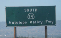 Route 14 from Route 5 to Avenue D, North of Lancaster (~ LA
R25.019 to LA R74.029), is officially named the "Antelope Valley
Freeway". It was named by Assembly Concurrent Resolution No. 57,
Chapter 196, in 1957. The name comes from the fact that the freeway
traverses the Antelope Valley. Antelope Valley was named for the graceful
animal once found throughout California.
Route 14 from Route 5 to Avenue D, North of Lancaster (~ LA
R25.019 to LA R74.029), is officially named the "Antelope Valley
Freeway". It was named by Assembly Concurrent Resolution No. 57,
Chapter 196, in 1957. The name comes from the fact that the freeway
traverses the Antelope Valley. Antelope Valley was named for the graceful
animal once found throughout California.
(Image source: Flikr)
 The portion from Pearblossom Highway to US 395 (~ LA R54.56 to KER 64.416) is
officially designated the "Aerospace Highway". This is because the
importance of this area to the aerospace industry, which includes the area
being the home to Edwards Air Force Base (EAFB), the home of the Air Force
Flight Test Center (AFFTC). Additionally, NASA Dryden Air Force Rocket
Propulsion Laboratory (AFRPL) at EAFB has contributed to the defense of
our country since 1954 through the development of virtually all the
nation's rocket propulsion technology, including the initiation of the
development and testing of several rocket engines, including the first
ATLAS Intercontinental Ballistic Missile (ICBM) in 1956; the first
full-scale Minuteman solid propellant ICBM in 1959; the Pratt &
Whitney XLR-129 Rocket Engine, which served as the precursor to the
Rocketdyne "Space Shuttle Main Engine" in 1964; and the Titan 34 Solid
Rocket Booster from the nozzle down to return Titan 34 to the nation's
launch service after the Challenger tragedy. The Edwards Rocket Site also
played a role in President John F. Kennedy's "Race to the Moon" when in
1961 Rocketdyne performed the first test firing of the 1,500,000 pound
thrust F-1 Engine for the Manned Lunar Launch Program; subsequently, it
was used as the location for over 7,000 development and acceptance test
firings of the F-1 Engine, including every engine used to launch men to
the moon. The AFRPL has continued to play a role in developing space
technology, helping to develop the nation's largest hydrogen rocket engine
for the Boeing Evolved Expendable Launch Vehicle (EELV) and "Attitude
Control Thrusters Systems" for satellite and space maneuvering
applications. The former Palmdale Airport was converted in 1953 into Air
Force Plant 42, which has supported facilities for the production,
engineering, final assembly, and flight testing of many notable
high-performance aircraft from Boeing, Lockheed-Martin, and Northrop
Grumman, including the F-100 Super Sabre, F-104 Starfighter, SR-71
Blackbird, B-1 Lancer, Space Shuttle, F-117 Nighthawk, B-2 Spirit, and
U-2S reconnaissance plane. Some of the numerous milestones in flight have
taken place at the AFFTC in its 50-year history, including the following:
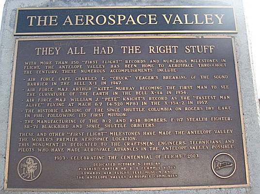
The portion from Pearblossom Highway to US 395 (~ LA R54.56 to KER 64.416) is
officially designated the "Aerospace Highway". This is because the
importance of this area to the aerospace industry, which includes the area
being the home to Edwards Air Force Base (EAFB), the home of the Air Force
Flight Test Center (AFFTC). Additionally, NASA Dryden Air Force Rocket
Propulsion Laboratory (AFRPL) at EAFB has contributed to the defense of
our country since 1954 through the development of virtually all the
nation's rocket propulsion technology, including the initiation of the
development and testing of several rocket engines, including the first
ATLAS Intercontinental Ballistic Missile (ICBM) in 1956; the first
full-scale Minuteman solid propellant ICBM in 1959; the Pratt &
Whitney XLR-129 Rocket Engine, which served as the precursor to the
Rocketdyne "Space Shuttle Main Engine" in 1964; and the Titan 34 Solid
Rocket Booster from the nozzle down to return Titan 34 to the nation's
launch service after the Challenger tragedy. The Edwards Rocket Site also
played a role in President John F. Kennedy's "Race to the Moon" when in
1961 Rocketdyne performed the first test firing of the 1,500,000 pound
thrust F-1 Engine for the Manned Lunar Launch Program; subsequently, it
was used as the location for over 7,000 development and acceptance test
firings of the F-1 Engine, including every engine used to launch men to
the moon. The AFRPL has continued to play a role in developing space
technology, helping to develop the nation's largest hydrogen rocket engine
for the Boeing Evolved Expendable Launch Vehicle (EELV) and "Attitude
Control Thrusters Systems" for satellite and space maneuvering
applications. The former Palmdale Airport was converted in 1953 into Air
Force Plant 42, which has supported facilities for the production,
engineering, final assembly, and flight testing of many notable
high-performance aircraft from Boeing, Lockheed-Martin, and Northrop
Grumman, including the F-100 Super Sabre, F-104 Starfighter, SR-71
Blackbird, B-1 Lancer, Space Shuttle, F-117 Nighthawk, B-2 Spirit, and
U-2S reconnaissance plane. Some of the numerous milestones in flight have
taken place at the AFFTC in its 50-year history, including the following:
(Image source: Waymarking)
The Aerospace Highway was designated by ACR 119, Chapter 83, 6/20/2002. Additionally, an encroachment permit authorizing a specified historical monument and plaque dedicated to commemorate the major milestones in the aerospace industry that have taken place in the Antelope Valley was authorized to be erected on the vista point overlooking Palmdale Lake on Route 14 (~ LA R56.804) by ACR 120, Chapter 84, 6/20/2002.
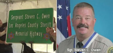 The portion of Route 14 in the City of Palmdale from E. Ave. S (~ LA R58.195) to E. Ave.
R (~ LA R59.157) in Los Angeles County is named the "Los Angeles
County Sheriff’s Sergeant Steven C. Owen Memorial Highway".
It was named after Sergeant Steven C. Owen of the Los Angeles County
Sheriff’s Department, who was killed in the line of duty. Sergeant
Owen was shot and killed in Lancaster, California on Wednesday, October 5,
2016, while responding to a residential burglary call that set off a
manhunt for a gunman who tried to flee in the slain lawman’s cruiser
and who held two teenagers hostage before he was captured. Sergeant Owen
was only 53 years of age at the time of his passing, and he was a 29-year
department veteran who began his career in law enforcement with the Los
Angeles County Sheriff’s Department on March 11, 1987, as part of a
class of 240. Over the course of his career with the department, Sergeant
Owen had the opportunity to serve as a deputy, school resource deputy,
field training officer, and detective, providing expertise to the Custody
Division’s East Facility, Lynwood Station, and to Transit Services
in Field Ops Region II, and to the Antelope Valley and Lancaster stations
in Field Ops Region I. Sergeant Owen was first assigned to the Lancaster
Station in June 1996, where he was promoted to sergeant in 2011, and since
that time he served the residents of Lancaster. He also served with the
department’s mounted enforcement detail as both a deputy and
sergeant, assisting with crowd control, parades, lost children, and
various patrol activities from horseback. Sergeant Owen received numerous
accolades for his efforts and achievements, including professional
commendations from the Federal Bureau of Investigation of the United
States Department of Justice, the Los Angeles County Board of Supervisors,
the United States Marine Corps, the California Attorney General, and the
Massachusetts State Police. In 2014, Sergeant Owen was awarded the Medal
of Valor, the department’s highest honor. Upon his passing, he is
survived by his beloved family, including his wife, Tania, a detective
assigned to the department’s Arson/Explosives Detail. Named by
Assembly Concurrent Resolution 31, 8/31/2017, Res. Chapter 135, Statutes
of 2017.
The portion of Route 14 in the City of Palmdale from E. Ave. S (~ LA R58.195) to E. Ave.
R (~ LA R59.157) in Los Angeles County is named the "Los Angeles
County Sheriff’s Sergeant Steven C. Owen Memorial Highway".
It was named after Sergeant Steven C. Owen of the Los Angeles County
Sheriff’s Department, who was killed in the line of duty. Sergeant
Owen was shot and killed in Lancaster, California on Wednesday, October 5,
2016, while responding to a residential burglary call that set off a
manhunt for a gunman who tried to flee in the slain lawman’s cruiser
and who held two teenagers hostage before he was captured. Sergeant Owen
was only 53 years of age at the time of his passing, and he was a 29-year
department veteran who began his career in law enforcement with the Los
Angeles County Sheriff’s Department on March 11, 1987, as part of a
class of 240. Over the course of his career with the department, Sergeant
Owen had the opportunity to serve as a deputy, school resource deputy,
field training officer, and detective, providing expertise to the Custody
Division’s East Facility, Lynwood Station, and to Transit Services
in Field Ops Region II, and to the Antelope Valley and Lancaster stations
in Field Ops Region I. Sergeant Owen was first assigned to the Lancaster
Station in June 1996, where he was promoted to sergeant in 2011, and since
that time he served the residents of Lancaster. He also served with the
department’s mounted enforcement detail as both a deputy and
sergeant, assisting with crowd control, parades, lost children, and
various patrol activities from horseback. Sergeant Owen received numerous
accolades for his efforts and achievements, including professional
commendations from the Federal Bureau of Investigation of the United
States Department of Justice, the Los Angeles County Board of Supervisors,
the United States Marine Corps, the California Attorney General, and the
Massachusetts State Police. In 2014, Sergeant Owen was awarded the Medal
of Valor, the department’s highest honor. Upon his passing, he is
survived by his beloved family, including his wife, Tania, a detective
assigned to the department’s Arson/Explosives Detail. Named by
Assembly Concurrent Resolution 31, 8/31/2017, Res. Chapter 135, Statutes
of 2017.
(Image source: ABC7, 10/5/2017)
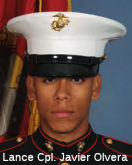 The portion of Route 14 in the City of Palmdale from the
south junction of Route 14 and Route 138 (~ LA R59.816) to West Avenue O8
(~ LA R62.145) is named the Lance Corporal Javier Olvera Memorial
Highway. It was named in memory of Javier Olvera, born in 1988 in
the Sylmar, California. Mr. Olvera attended R. Rex Parris High School in
the Antelope Valley, during which he participated and excelled in the
Police Explorer program. While watching military programs on the History
Channel, Mr. Olvera became interested in the United States Marine Corps.
Hoping to take his life in a positive direction, in 2006 Mr. Olvera
enlisted in the United States Marine Corps and was sent to the Marine
Corps Recruit Depot in San Diego, California. Mr. Olvera graduated from
Marine Corps boot camp with his platoon on February 23, 2007. Mr. Olvera
was then sent to Camp Lejeune in North Carolina for training as a 0311
Infantryman, where his specialty was as a radio operator, a highly
dangerous job, often targeted in battle by the enemy. On August 1, 2007,
Mr. Olvera was promoted to the rank of Lance Corporal. In September 2007,
Lance Corporal Olvera deployed to Iraq, where he stayed until February
2008, when he returned to the United States. Lance Corporal Olvera was
again called to service in May 2009, and subsequently deployed with 2nd
Battalion, 8th Marines with a contingent of 21,000 other Marines to
Afghanistan. On August 8, 2009, Lance Corporal Olvera was killed in action
by an improvised explosive device (IED). Named by Senate Concurrent
Resolution 60, chaptered 2/3/2014, Resolution Chapter 6.
The portion of Route 14 in the City of Palmdale from the
south junction of Route 14 and Route 138 (~ LA R59.816) to West Avenue O8
(~ LA R62.145) is named the Lance Corporal Javier Olvera Memorial
Highway. It was named in memory of Javier Olvera, born in 1988 in
the Sylmar, California. Mr. Olvera attended R. Rex Parris High School in
the Antelope Valley, during which he participated and excelled in the
Police Explorer program. While watching military programs on the History
Channel, Mr. Olvera became interested in the United States Marine Corps.
Hoping to take his life in a positive direction, in 2006 Mr. Olvera
enlisted in the United States Marine Corps and was sent to the Marine
Corps Recruit Depot in San Diego, California. Mr. Olvera graduated from
Marine Corps boot camp with his platoon on February 23, 2007. Mr. Olvera
was then sent to Camp Lejeune in North Carolina for training as a 0311
Infantryman, where his specialty was as a radio operator, a highly
dangerous job, often targeted in battle by the enemy. On August 1, 2007,
Mr. Olvera was promoted to the rank of Lance Corporal. In September 2007,
Lance Corporal Olvera deployed to Iraq, where he stayed until February
2008, when he returned to the United States. Lance Corporal Olvera was
again called to service in May 2009, and subsequently deployed with 2nd
Battalion, 8th Marines with a contingent of 21,000 other Marines to
Afghanistan. On August 8, 2009, Lance Corporal Olvera was killed in action
by an improvised explosive device (IED). Named by Senate Concurrent
Resolution 60, chaptered 2/3/2014, Resolution Chapter 6.
(Image source: LA Times)
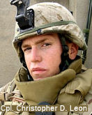 The portion of Route 14 in the County of Los
Angeles, between Avenue M and Avenue L (~ LA R64.681 to LA R65.697) in the
City of Lancaster is named the "Marine Corporal Christopher D. Leon
Memorial Highway". This segment was named in memory of Marine
Corporal Christopher D. Leon, born on November 5, 1985, in Thousand Oaks,
California. Corporal Leon was a 2004 graduate of Lancaster High School,
and left for boot camp in the Marine Corps in San Diego shortly after
graduating. Corporal Christopher D. Leon was described by fellow members
of the Marine Corps as having a heart of a lion and this characteristic
was displayed on many occasions, including when he broke his foot during a
boot camp exercise called "the crucible" but still managed to courageously
finish 10 miles of hiking and more miles of running with that broken foot.
Leon made rank quickly and obtained his corporal's stripes before two
years in service. He was assigned to the 5th Air Naval Gunfire Liaison
Company (ANGLICO), III Marine Expeditionary Force, in Okinawa, Japan and
excelled in ANGLICO training and in the Marine Corps Martial Arts Program.
As a liaison company member, Corporal Leon was trained to quickly pinpoint
the source of enemy fire from ground troops, helicopters, or attack plans
and then to direct counter-fire. On June 20, 2006, at 20 years of age,
Corporal Leon died from injuries suffered in combat in the western
province of Al Anbar, Iraq. Named by Senate Concurrent Resolution (SCR) 5,
Resolution Chapter 70, on 7/14/2009.
The portion of Route 14 in the County of Los
Angeles, between Avenue M and Avenue L (~ LA R64.681 to LA R65.697) in the
City of Lancaster is named the "Marine Corporal Christopher D. Leon
Memorial Highway". This segment was named in memory of Marine
Corporal Christopher D. Leon, born on November 5, 1985, in Thousand Oaks,
California. Corporal Leon was a 2004 graduate of Lancaster High School,
and left for boot camp in the Marine Corps in San Diego shortly after
graduating. Corporal Christopher D. Leon was described by fellow members
of the Marine Corps as having a heart of a lion and this characteristic
was displayed on many occasions, including when he broke his foot during a
boot camp exercise called "the crucible" but still managed to courageously
finish 10 miles of hiking and more miles of running with that broken foot.
Leon made rank quickly and obtained his corporal's stripes before two
years in service. He was assigned to the 5th Air Naval Gunfire Liaison
Company (ANGLICO), III Marine Expeditionary Force, in Okinawa, Japan and
excelled in ANGLICO training and in the Marine Corps Martial Arts Program.
As a liaison company member, Corporal Leon was trained to quickly pinpoint
the source of enemy fire from ground troops, helicopters, or attack plans
and then to direct counter-fire. On June 20, 2006, at 20 years of age,
Corporal Leon died from injuries suffered in combat in the western
province of Al Anbar, Iraq. Named by Senate Concurrent Resolution (SCR) 5,
Resolution Chapter 70, on 7/14/2009.
(Image source: LA Times)
 The portion of Route 14
in the County of Los Angeles from West Avenue K to West Avenue H (~LA
R66.755 to LA R69.995) in the City of Lancaster is named the "Senator
Sharon Runner Memorial Highway". Sharon Runner was born in May
1954, in the City of Los Angeles. She was a lifelong resident of the City
of Lancaster, California. Before embarking on her political career, Ms.
Runner cofounded Desert Christian Schools, which has grown to three
campuses with nearly 1,700 students. Runner served in the California State
Assembly from 2002 to 2008; and was elected to the California State Senate
in 2011. Senator Runner coauthored California’s version of
Jessica’s Law, approved by voters in 2006, to restrict sex offenders
from living near parks, schools, and other places where children
congregate. Senator Runner served on the board of California Women Lead, a
bipartisan organization that encourages and empowers women to run for
public office. In 1998, she was appointed by Governor Pete Wilson to serve
on the Antelope Valley Fair Board of Directors, where she oversaw the
operations of the 50th Agriculture District. In 2009, she was appointed by
Governor Schwarzenegger to the California Unemployment Insurance Appeals
Board. Throughout her life, Senator Runner volunteered her time on several
boards and committees, including the United Way, Antelope Valley Hospital
Gift Foundation, Antelope Valley Crime Task Force, Healthy Homes Advisory
Council, and Care Net. In 1984, at the age of 30, she was diagnosed with
limited scleroderma, also known as CREST syndrome, and received a
double-lung transplant in 2012. Following her high-profile illness and
recovery, Senator Runner volunteered with organizations committed to
increasing organ donations. She was reelected to the California State
Senate in 2015. Senator Sharon Runner passed away on July 14, 2016, after
experiencing respiratory complications. Named by Assembly Concurrent
Resolution (ACR) 138, Res. Chapter 160, Statutes of 2016 on September 1,
2016.
The portion of Route 14
in the County of Los Angeles from West Avenue K to West Avenue H (~LA
R66.755 to LA R69.995) in the City of Lancaster is named the "Senator
Sharon Runner Memorial Highway". Sharon Runner was born in May
1954, in the City of Los Angeles. She was a lifelong resident of the City
of Lancaster, California. Before embarking on her political career, Ms.
Runner cofounded Desert Christian Schools, which has grown to three
campuses with nearly 1,700 students. Runner served in the California State
Assembly from 2002 to 2008; and was elected to the California State Senate
in 2011. Senator Runner coauthored California’s version of
Jessica’s Law, approved by voters in 2006, to restrict sex offenders
from living near parks, schools, and other places where children
congregate. Senator Runner served on the board of California Women Lead, a
bipartisan organization that encourages and empowers women to run for
public office. In 1998, she was appointed by Governor Pete Wilson to serve
on the Antelope Valley Fair Board of Directors, where she oversaw the
operations of the 50th Agriculture District. In 2009, she was appointed by
Governor Schwarzenegger to the California Unemployment Insurance Appeals
Board. Throughout her life, Senator Runner volunteered her time on several
boards and committees, including the United Way, Antelope Valley Hospital
Gift Foundation, Antelope Valley Crime Task Force, Healthy Homes Advisory
Council, and Care Net. In 1984, at the age of 30, she was diagnosed with
limited scleroderma, also known as CREST syndrome, and received a
double-lung transplant in 2012. Following her high-profile illness and
recovery, Senator Runner volunteered with organizations committed to
increasing organ donations. She was reelected to the California State
Senate in 2015. Senator Sharon Runner passed away on July 14, 2016, after
experiencing respiratory complications. Named by Assembly Concurrent
Resolution (ACR) 138, Res. Chapter 160, Statutes of 2016 on September 1,
2016.
(Image source: SCVTV)
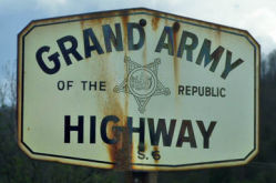 The portion of this route that was cosigned with US 6
(i.e., this entire segment) was named the "Grand Army of the Republic
Highway" by Assembly Concurrent Resolution 33, Chapter 73, in 1943.
The GAR is a membership organization founded in Decatur, Illinois on April
6, 1866 by Benjamin F. Stephenson. It's membership was limited to
honorably discharged veterans of the Union Army, Navy, Marine Corps or the
Revenue Cutter Service who had served between April 12, 1861 and April 9,
1865. The GAR is responsible for the establishment of Memorial Day, which
began in 1868 when GAR Commander-in-Chief John A. Logan issued General
Order No. 11 calling for all Departments and Posts to set aside the 30th
of May as a day for remembering the sacrifices of fallen comrades. The
final Encampment of the Grand Army of the Republic was held in
Indianapolis, Indiana in 1949 and the last member, Albert Woolson died in
1956 at the age of 109 years.
The portion of this route that was cosigned with US 6
(i.e., this entire segment) was named the "Grand Army of the Republic
Highway" by Assembly Concurrent Resolution 33, Chapter 73, in 1943.
The GAR is a membership organization founded in Decatur, Illinois on April
6, 1866 by Benjamin F. Stephenson. It's membership was limited to
honorably discharged veterans of the Union Army, Navy, Marine Corps or the
Revenue Cutter Service who had served between April 12, 1861 and April 9,
1865. The GAR is responsible for the establishment of Memorial Day, which
began in 1868 when GAR Commander-in-Chief John A. Logan issued General
Order No. 11 calling for all Departments and Posts to set aside the 30th
of May as a day for remembering the sacrifices of fallen comrades. The
final Encampment of the Grand Army of the Republic was held in
Indianapolis, Indiana in 1949 and the last member, Albert Woolson died in
1956 at the age of 109 years.
(Source: Information on the GAR excerpted
from the pages of the Sons of Union Veterans of the Civil War; Image source: KCET).
 Named Structures
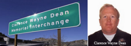 The I-5/Route 14 interchange
(~ LA R25.019) is officially designated the "Clarence Wayne Dean
Memorial Interchange". Officer Clarence Wayne Dean was a 26-year
veteran motorcycle cop for the Los Angeles Police Department. He lived in
Lancaster, north of the city, and worked out of the Van Nuys station in
the San Fernando Valley. He joined the Los Angeles force in 1968 after
four years in the Marines, leaving the military with the rank of sergeant.
He had been a motorcycle officer for ten years. In November 1993 he hurt
his back and took a desk job. A few weeks later, he returned to work
healthy enough to go back on the street. On January 17, 1994, a 6.6
earthquake struck the San Fernando Valley's Northridge area. The Newhall
Pass sections of the I-5/Route 14 freeway interchange collapsed. Officer
Dean was unaware of the collapse. While rounding a turn on a soaring
overpass, he sailed into space astride his motorcyle, unable to stop. The
interchange was renamed the "Clarence Wayne Dean Memorial Interchange" in
his honor. Named by Assembly Concurrent Resolution No. 111, Chapter 64, in
1994.
The I-5/Route 14 interchange
(~ LA R25.019) is officially designated the "Clarence Wayne Dean
Memorial Interchange". Officer Clarence Wayne Dean was a 26-year
veteran motorcycle cop for the Los Angeles Police Department. He lived in
Lancaster, north of the city, and worked out of the Van Nuys station in
the San Fernando Valley. He joined the Los Angeles force in 1968 after
four years in the Marines, leaving the military with the rank of sergeant.
He had been a motorcycle officer for ten years. In November 1993 he hurt
his back and took a desk job. A few weeks later, he returned to work
healthy enough to go back on the street. On January 17, 1994, a 6.6
earthquake struck the San Fernando Valley's Northridge area. The Newhall
Pass sections of the I-5/Route 14 freeway interchange collapsed. Officer
Dean was unaware of the collapse. While rounding a turn on a soaring
overpass, he sailed into space astride his motorcyle, unable to stop. The
interchange was renamed the "Clarence Wayne Dean Memorial Interchange" in
his honor. Named by Assembly Concurrent Resolution No. 111, Chapter 64, in
1994.
(Image Sources: Washington Times; Find A Grave)
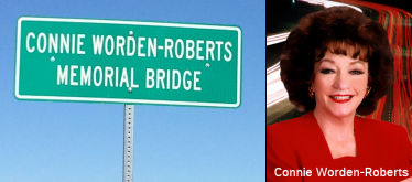 The Golden Valley Road Bridge over Route 14 (~ LA R29.71) in the City of Santa Clarita, County of Los
Angeles, is named the "Connie Worden-Roberts Memorial Bridge". It
was named in memory of Connie Worden-Roberts, who demonstrated
extraordinary service to the Santa Clarita Valley community and was known
as the Santa Clarita Valley’s “Road Warrior”. In
particular, Connie Worden-Roberts championed the development of the
valley’s transportation network for nearly four decades, serving as
the vice-chair of the City of Santa Clarita Formation Committee and
serving on the city’s first planning commission. Worden-Roberts also
served as chairwoman of the League of Women Voters of Los Angeles County,
founder of the Valley Industry Association, former chairwoman of the board
and director of the Santa Clarita Valley Chamber of Commerce, and as a
member of many more community organizations. Lastly, Worden-Roberts was an
early visionary and tireless advocate for the Golden Valley Road Bridge
project, knowing it was necessary to meet the needs of the growing valley.
Sadly, Connie Worden-Roberts passed away on August 12, 2014. Named by
Assembly Concurrent Resolution 89, Resolution Chapter 187, on 09/21/15.
The Golden Valley Road Bridge over Route 14 (~ LA R29.71) in the City of Santa Clarita, County of Los
Angeles, is named the "Connie Worden-Roberts Memorial Bridge". It
was named in memory of Connie Worden-Roberts, who demonstrated
extraordinary service to the Santa Clarita Valley community and was known
as the Santa Clarita Valley’s “Road Warrior”. In
particular, Connie Worden-Roberts championed the development of the
valley’s transportation network for nearly four decades, serving as
the vice-chair of the City of Santa Clarita Formation Committee and
serving on the city’s first planning commission. Worden-Roberts also
served as chairwoman of the League of Women Voters of Los Angeles County,
founder of the Valley Industry Association, former chairwoman of the board
and director of the Santa Clarita Valley Chamber of Commerce, and as a
member of many more community organizations. Lastly, Worden-Roberts was an
early visionary and tireless advocate for the Golden Valley Road Bridge
project, knowing it was necessary to meet the needs of the growing valley.
Sadly, Connie Worden-Roberts passed away on August 12, 2014. Named by
Assembly Concurrent Resolution 89, Resolution Chapter 187, on 09/21/15.
(Image source: Santa Clarita City Briefs; SCV History/KHTS)
On February 26, 2002, Caltrans unveiled its first-ever "Don't Drink and Drive" freeway sign near Acton, in memory of Callie "Joel" Buser, a Caltrans surveyor who was killed while performing survey work by a drugged driver. Joel Buser, a 55-year-old Caltrans worker, was killed July 29, 1992, by a vehicle driven by Scott Ellis III of Palmdale while Buser was surveying a stretch of freeway near Soledad Canyon Road. Ellis was later sentenced to 10 years in prison for gross vehicular manslaughter while under the influence of drugs. Since his death, Buser has been memorialized through a scholarship fund for students studying to become surveyors as well as having Caltrans' North Los Angeles Regional Survey Office renamed in his honor. (Somewhere near LA R48.515)
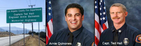 The interchange on Route 14 with the Angeles Forest Highway
(Los Angeles County Sign Route N3) (~ LA R54.393) in the County of Los Angeles is
officially named the "Captain Ted Hall and Engineer Arnie Quinones
Memorial Interchange". It was named in memory of Fire Captain Ted
Hall and Fire Figher Specialist Arnie Quinones. Fire Captain Tedmund D.
"Ted" Hall first joined the Los Angeles County Fire Department in 1981 as
a student worker, and graduated from the fire academy in 1983, serving as
a firefighter in Lakewood, Whittier, and La Puente. In 1987, Mr. Hall
joined the department's command and control team of fire dispatchers, and
was promoted to Fire Fighter Specialist in 1988, serving as an engineer at
various locations. He was promoted to captain in 2001, with his final
assignment at Camp 16 in the Palmdale region. Fire Fighter Specialist
Arnaldo "Arnie" Quinones first joined the Los Angeles County Fire
Department in 1998, as a member of the department's call fire fighter
program, and graduated from the fire academy in 2001, serving as a
firefighter in Palmdale, Covina, and La Canada-Flintridge. In 2005, Mr.
Quinones was promoted to Fire Fighter Specialist, with his final
assignment as an engineer at Camp 16 in the Palmdale region. Captain Hall
and Fire Fighter Specialist Quinones were both tragically killed in the
line of duty on Sunday, August 30, 2009, during the Station Fire, when
their emergency response vehicle went over the side and fell 800 feet into
a steep canyon during fire suppression activities. Named by Assembly
Concurrent Resolution 58, Resolution Chapter 108, on September 28, 2011.
The interchange on Route 14 with the Angeles Forest Highway
(Los Angeles County Sign Route N3) (~ LA R54.393) in the County of Los Angeles is
officially named the "Captain Ted Hall and Engineer Arnie Quinones
Memorial Interchange". It was named in memory of Fire Captain Ted
Hall and Fire Figher Specialist Arnie Quinones. Fire Captain Tedmund D.
"Ted" Hall first joined the Los Angeles County Fire Department in 1981 as
a student worker, and graduated from the fire academy in 1983, serving as
a firefighter in Lakewood, Whittier, and La Puente. In 1987, Mr. Hall
joined the department's command and control team of fire dispatchers, and
was promoted to Fire Fighter Specialist in 1988, serving as an engineer at
various locations. He was promoted to captain in 2001, with his final
assignment at Camp 16 in the Palmdale region. Fire Fighter Specialist
Arnaldo "Arnie" Quinones first joined the Los Angeles County Fire
Department in 1998, as a member of the department's call fire fighter
program, and graduated from the fire academy in 2001, serving as a
firefighter in Palmdale, Covina, and La Canada-Flintridge. In 2005, Mr.
Quinones was promoted to Fire Fighter Specialist, with his final
assignment as an engineer at Camp 16 in the Palmdale region. Captain Hall
and Fire Fighter Specialist Quinones were both tragically killed in the
line of duty on Sunday, August 30, 2009, during the Station Fire, when
their emergency response vehicle went over the side and fell 800 feet into
a steep canyon during fire suppression activities. Named by Assembly
Concurrent Resolution 58, Resolution Chapter 108, on September 28, 2011.
(Image source: LA County Fire on Twitter)
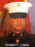 The Rosamond Boulevard Interchange of Route 14 (~ KER R3.078) in the City of Rosamond is named
the "Lance Corporal Joseph C. Lopez Memorial Interchange". Named
in memory of Joseph C. Lopez, who enlisted in the Marine Corps in March
2009, and was assigned to the 3rd Battalion, 5th Marine Regiment, 1st
Marine Division, 1st Marine Expeditionary Force at Camp Pendleton. Lance
Corporal Lopez was a strong Marine, physically and mentally, who made a
conscious decision to let his faith in God lead him through whatever might
happen. Lance Corporal Lopez was a mentor to many younger Marines from his
life experiences and helped his fellow Marine brothers simply by being a
good listener. Lance Corporal Lopez was deployed to the Sangin district of
the Helmand province of Afghanistan in late September 2010, with his unit.
On October 14th, 2010, Lance Corporal Lopez had returned safely to his
Marine camp, after successfully patrolling an area of responsibility for
more than 20 hours on foot. Lance Corporal Lopez's team was then
dispatched to a nearby location to assist a Marine unit taking heavy fire.
The then 26-year-old Lance Corporal Lopez was killed by an improvised
explosive device during that combat operation in Helmand province. In
2011, Lance Corporal Lopez's family and church established an inaugural
annual five kilometer run in remembrance of him, in which members of his
Marine unit participated, all proceeds of which are donated to the Wounded
Warriors Project and church youth programs. Named by Senate Concurrent
Resolution 80, Resolution Chapter 89, on August 24, 2012.
The Rosamond Boulevard Interchange of Route 14 (~ KER R3.078) in the City of Rosamond is named
the "Lance Corporal Joseph C. Lopez Memorial Interchange". Named
in memory of Joseph C. Lopez, who enlisted in the Marine Corps in March
2009, and was assigned to the 3rd Battalion, 5th Marine Regiment, 1st
Marine Division, 1st Marine Expeditionary Force at Camp Pendleton. Lance
Corporal Lopez was a strong Marine, physically and mentally, who made a
conscious decision to let his faith in God lead him through whatever might
happen. Lance Corporal Lopez was a mentor to many younger Marines from his
life experiences and helped his fellow Marine brothers simply by being a
good listener. Lance Corporal Lopez was deployed to the Sangin district of
the Helmand province of Afghanistan in late September 2010, with his unit.
On October 14th, 2010, Lance Corporal Lopez had returned safely to his
Marine camp, after successfully patrolling an area of responsibility for
more than 20 hours on foot. Lance Corporal Lopez's team was then
dispatched to a nearby location to assist a Marine unit taking heavy fire.
The then 26-year-old Lance Corporal Lopez was killed by an improvised
explosive device during that combat operation in Helmand province. In
2011, Lance Corporal Lopez's family and church established an inaugural
annual five kilometer run in remembrance of him, in which members of his
Marine unit participated, all proceeds of which are donated to the Wounded
Warriors Project and church youth programs. Named by Senate Concurrent
Resolution 80, Resolution Chapter 89, on August 24, 2012.
(Image source: LA Times)
 National Trails
 This segment was part of the "Midland Trail".
 Commuter Lanes
 From Route 58 to Route 395 near Little Lake via the vicinity of Antelope
Valley.
From Route 58 to Route 395 near Little Lake via the vicinity of Antelope
Valley.
Pre 1964 Signage History In the 1934 initial state signage, this portion of the route was numbered as Route 7. When state routes began to be shielded as US highways, this was resigned as US 6. This was also part of the 1911
extension of LRN 23.
StatusMojave / California City (Route 58) to near N edge of Red Rock Canyon (~ KER 18.983 to KER 44)
An interchange is being built at the south end of the Mojave Bypass for WB Route 58 to SB Route 14 and NB Route 14 to EB Route 58 movements (06-Ker-14 16.026). This will create a single stop light for those most common movements at the existing Route 14/Route 58 intersection. For other movements, you will travel north on Route 14 all the way to Route 58 through Mojave. There are currently insufficient traffic volumes aren't high enough for a Route 14 freeway to the Route 58 freeway. However, according to Joe Rouse at Caltrans, there were originally plans for Route 14 to bypass Mojave on the east. A new freeway spur would have connected with the east segment of Route 58. At the north end of the town, the mainline of the freeway would become Route 58 west and a new freeway spur would have connected with Route 14 north. These would have been large interchanges and faced community opposition. Additional funding for this interchange was considered in September 2005.
There were once plans to build a bypass in the Mojave area to the west of town. Now, if this ever gets built, it will be to the east of town. A four-lane expressway has been completed from Mojave through Red Rock Canyon, with a full grade-separated interchange at California City Blvd, and frontage roads extending from several miles north of that down almost to the town. The 16 miles north of Red Rock Canyon remain as two-lane road.
In January 2011, the CTC authorized relinquishment of right of way in the county of Kern along Route 14 between 4.2 miles south and 2.3 miles north of California City Boulevard (~ KER 17.084 to KER 23.584), consisting of superseded highway right of way and collateral facilities.
In August 2010, the CTC approved relinquishment of right of way in the city of California City along Route 14, on Pesche Boulevard, California City Boulevard, and Leiman Road, consisting of collateral facilities (~ KER 21.284).
Red Rock Canyon Bridge (KER PM 39.9)
In August 2012, the CTC approved for future consideration of funding a project that will remove and replace the existing Red Rock Canyon Bridge (Bridge Number 50-0178) on Route 14 within Red Rock Canyon State Park (between Mojave and Inyokern). The project is programmed in the 2012 State Highway Operation and Protection Program (SHOPP). The total estimated cost is $19,485,000 for capital and support. Construction is estimated to begin in Fiscal Year 2013-14. The scope, as described for the preferred alternative, is consistent with the project scope programmed by the Commission in the 2012 SHOPP. A copy of the MND has been provided to Commission staff. The project will mitigate potential impacts to biological and aesthetic resources to a less than significant level. Proposed mitigation measures include protective fencing and best management practices for the desert tortoise, a special status species. Color and texture features incorporated into the final design will mitigate aesthetic issues.
In March 2013, the CTC provided advance approval of $9,970,000 to replace the existing Red Rock Canyon Bridge (Bridge #50-0178) near Ridgecrest with a new longer, wider, and scour resistant bridge to reduce future bridge repair frequency and cost, and improve traffic operations and safety.
Red Rock Canyon to Jct US 395 (~ KER 44 to KER 64.416)
Freeman Gulch Four-Lane Project
2007 CMIA. One project was submitted to the Corridor Mobility Improvement Account for funding: expansion of the route to 4 lanes between Redrock Inyokern (~KER 45.061) and Route 178 (~ KER 57.733) ($129,278K requested). It was not recommended for funding.
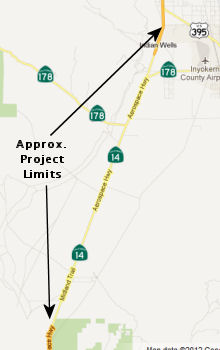 In April 2012, the CTC approved for future consideration of funding a project
in Kern County near the community of Freeman that will convert the
existing two-lane conventional highway into a four-lane divided
controlled-access expressway on Route 14 from 0.8 mile north of Redrock
Inyokern Road to 2.2 miles south of the junction with US 395. The "Freeman
Gulch Four-Lane Project," consisting of a conversion to a four-lane
expressway with a wide median, has been planned with the approval of a
Project Study Report in 2001. The Project Report was approved on October
29, 2007 and the Initial Study with Mitigated Negative
Declaration/Environmental Assessment with Finding of No Significance
Impact was approved on October 3, 2007. A Supplemental Project Report that
split the project into three segments was approved on April 12, 2010. The
northern segment of this project, which includes the proposed route
adoption and extends from 0.5 mile north of the Route 178 West junction to
1.7 miles north of Route 178 East junction (PM 58.3 to 62.3), is the first
segment proposed to be constructed and programmed for construction
capital.The project will be phased into three segments. Segment 1 is
programmed in the 2012 State Transportation Improvement Program (STIP) and
is fully funded, at a cost of $44,888,000. Segment 2 is partially
programmed in the 2012 STIP; the cost for this segment is $47,687,000, of
which $10,860,000 is programmed. Segment 3 is not currently programmed nor
funded; the cost for this segment is $31,544,000. The total estimated
project cost for all three phases is $124,119,000 for capital and support.
Construction for Segment 1 is estimated to begin in Fiscal Year 2016-17.
The scope, as described for the preferred alternative, is consistent with
the project scope programmed by the Commission in the STIP.
In April 2012, the CTC approved for future consideration of funding a project
in Kern County near the community of Freeman that will convert the
existing two-lane conventional highway into a four-lane divided
controlled-access expressway on Route 14 from 0.8 mile north of Redrock
Inyokern Road to 2.2 miles south of the junction with US 395. The "Freeman
Gulch Four-Lane Project," consisting of a conversion to a four-lane
expressway with a wide median, has been planned with the approval of a
Project Study Report in 2001. The Project Report was approved on October
29, 2007 and the Initial Study with Mitigated Negative
Declaration/Environmental Assessment with Finding of No Significance
Impact was approved on October 3, 2007. A Supplemental Project Report that
split the project into three segments was approved on April 12, 2010. The
northern segment of this project, which includes the proposed route
adoption and extends from 0.5 mile north of the Route 178 West junction to
1.7 miles north of Route 178 East junction (PM 58.3 to 62.3), is the first
segment proposed to be constructed and programmed for construction
capital.The project will be phased into three segments. Segment 1 is
programmed in the 2012 State Transportation Improvement Program (STIP) and
is fully funded, at a cost of $44,888,000. Segment 2 is partially
programmed in the 2012 STIP; the cost for this segment is $47,687,000, of
which $10,860,000 is programmed. Segment 3 is not currently programmed nor
funded; the cost for this segment is $31,544,000. The total estimated
project cost for all three phases is $124,119,000 for capital and support.
Construction for Segment 1 is estimated to begin in Fiscal Year 2016-17.
The scope, as described for the preferred alternative, is consistent with
the project scope programmed by the Commission in the STIP.
In relation to this project, in April 2012, the CTC adopted a portion of Route 14 as a controlled access highway from 0.1 mile north of Route 178 West junction, south of the unincorporated rural community of Indian Wells, to 1.4 miles north of Route 178 East junction. A Project Report was approved on October 29, 2007. A Supplemental Project Report was approved on April 12, 2010 to phase the project into three segments to fully fund each segment. An Initial Study with Mitigated Negative Declaration was prepared for California Environmental Quality Act and the document was approved on October 3, 2007. The purpose of the adoption was to designate the remaining segment of conventional highway for Route 14 as a controlled access highway (expressway). The proposed route adoption was prepared by the Department with support from Kern County and Kern Council of Governments (KernCOG). This route adoption corresponds to the northern segment of the project referred to as the Freeman Gulch Four-Lane Project (PM 45.9 to 62.3) and runs through the unincorporated rural community of Indian Wells. The ultimate facility will be a four-lane divided controlled access highway with increased capacity and will improve traffic safety and operations of Route 14. The portion of Route 14 proposed for route adoption is a two-lane conventional highway, where as the portions directly south and north of the proposed route adoption are two-lane expressways. Just south of the proposed adoption segment, Route 14 was adopted by the California Highway Commission as a freeway in 1956 and denominated as a controlled access highway on March 30, 2012. Just north of the proposed adoption segment, Route 14 was adopted by the Commission as a controlled access highway on June 28, 1989. Following the completion of this project, Route 14 will be a continuous 4-lane facility along its entire length from its beginning at I-5 in Los Angeles County to US 395 in Kern County. It should be noted that the portion of Route 14 covered by this project is the last segment of the route that has not been converted to a 4-lane facility. This project will greatly enhance the continuity of this route and provide a continuous 4-lane expressway from I-5 through Kern County and along US 395 up to near Olancha in Inyo County (a distance of 150 miles).
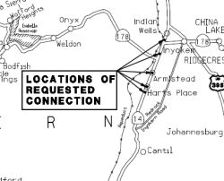 In May 2013, the CTC authorized public road connections in the county of Kern
at approximate PM 48.9, 50.2, 53.5, 58.9 and 61.2. These new connections
are located between 1.1 miles north of Redrock Inyokern Road and 1.4 miles
north of the Route 178 East Junction in Kern County. This is part of the
Freeman Gulch Four-Lane project, which includes construction of frontage
roads and new connections to Route 14 at five locations. These new public
road connections are needed to provide access to clusters of private
parcels on both sides of Route 14 at each location. The ultimate facility
will be a four-lane divided controlled access highway with increased
capacity and improved operations and safety. Route 14 within the project
limits is an undivided two-lane conventional highway, whereas the portions
directly south and north are four-lane controlled access highways
(expressways). The Department is proposing to convert the existing Route 14 within the project limits to a multilane expressway and provide route
continuity with the existing expressway at each end of the project limits.
The proposed highway improvements also include construction of frontage
roads and new connections to Route 14 at five locations. These new
connections are required to provide access to clusters of private parcels
and Bureau of Land Management (BLM) public dirt roads. Currently, there
are many private parcels connecting directly to the highway via driveways.
These private parcels do not have access to any other local roads.
Additionally, there are a number of BLM public dirt roads, used for
recreational purposes, which also have direct access to both directions of
the highway. As a result of the controlled access highway project
proposal, the BLM roads will be modified to connect to the frontage roads
and this way continue to have access to Route 14. The proposed reduced
number of access points to the highway would improve traffic operations
and enhance traffic safety along Route 14 and at the Route 178 east and
west junctions.
In May 2013, the CTC authorized public road connections in the county of Kern
at approximate PM 48.9, 50.2, 53.5, 58.9 and 61.2. These new connections
are located between 1.1 miles north of Redrock Inyokern Road and 1.4 miles
north of the Route 178 East Junction in Kern County. This is part of the
Freeman Gulch Four-Lane project, which includes construction of frontage
roads and new connections to Route 14 at five locations. These new public
road connections are needed to provide access to clusters of private
parcels on both sides of Route 14 at each location. The ultimate facility
will be a four-lane divided controlled access highway with increased
capacity and improved operations and safety. Route 14 within the project
limits is an undivided two-lane conventional highway, whereas the portions
directly south and north are four-lane controlled access highways
(expressways). The Department is proposing to convert the existing Route 14 within the project limits to a multilane expressway and provide route
continuity with the existing expressway at each end of the project limits.
The proposed highway improvements also include construction of frontage
roads and new connections to Route 14 at five locations. These new
connections are required to provide access to clusters of private parcels
and Bureau of Land Management (BLM) public dirt roads. Currently, there
are many private parcels connecting directly to the highway via driveways.
These private parcels do not have access to any other local roads.
Additionally, there are a number of BLM public dirt roads, used for
recreational purposes, which also have direct access to both directions of
the highway. As a result of the controlled access highway project
proposal, the BLM roads will be modified to connect to the frontage roads
and this way continue to have access to Route 14. The proposed reduced
number of access points to the highway would improve traffic operations
and enhance traffic safety along Route 14 and at the Route 178 east and
west junctions.
In October 2016, the CTC approved the following STIP allocation: 06-Ker-14 58.3/62.3 | Route 14 Freeman Gulch Widening - Segment 1. Near Ridgecrest, from 0.5 mile north of Route 178 west to 1.7 miles north of Route 178 east. Convert from 2-lane conventional highway to 4-lane expressway. $31,088,000
In December 2017, it was reported that, after nearly a
decade of planning and six months of construction, a stretch of Route 14
from just before the Inyokern Road/Route 178 to just before the Indian
Wells Brewing Company and Lodge have been transformed. The Freeman Gulch
project, a multi-million dollar project, will convert the stretch of
highway from two lanes to a four-lane expressway meant to improve traffic
flow and safety, according to Caltrans District 9. The northbound portion
is already done, including a part of the new turnoff/turnon at Inyokern
Road. The first stage was to build the new northbound lane and now that is
done, and traffic is on those. The ultimate goal of the Freeman Gulch
widening will close the final 2-lane ‘gap’ on Route 14 between
Mojave and the junction with Route 395. Improvements include grading and
drainage, which is also halfway done, something attributed to extended
shifts and working on Saturdays. For now, however, traffic will still be
considered a two-lane highway until the southbound lanes are completed.
Currently, construction crews are working on the second phase, which goes
south from the US 395 turnoff. Caltrans has established a detour that
shunts traffic onto the already-finished northbound lanes. Caltrans
Resident Engineer Sam Dhaliwal added that the lanes are a little wider,
and includes a four-foot “soft” median distinguished by double
yellow lines. The shoulders are also consistent going through the current
route. New lighting has already been installed at the Inyokern Road
intersection, which utilizes LED bulbs he described as “super
bright.” Traffic will be separated by permanent medians. The project
has been supported by Kern Council of Governments (KERNCOG) and Inyo and
Mono counties. Segment 1 has a construction cost of approximately $27.9
million. Caltrans is currently working with the KERNCOG, Inyo and Mono
counties to program funding for the second and third segments. Segment 2
“will upgrade approximately 6.2 miles of two-lane conventional
highway to a four-lane expressway from 4.8 miles south to 0.5 miles north
of Route 178 West,” according to segment two fact sheet. Segment 3
will “upgrade 7.1 miles of two-lane conventional highway to
four-lane expressway from north of Red Rock State Park to 4.8 miles south
of Route 178,” according to segment three fact sheet.
(Source: Ridgecrest Daily Independent, 12/5/2017)
The 2018 STIP, approved at the CTC March 2018 meeting, appears to close out Segment 1 of PPNO 8042A, the Freeman Gulch widening Segment 1 (PM KER 58.3/62.3): Near Ridgecrest, from 0.5 mile north of Route 178 west to 1.7 miles north of Route 178 east. Convert from 2-lane conventional highway to 4-lane expressway. It restores $1,960K in funding for PPNO 8042B, for segment 2, KER 53.0/58.3, Near Ridgecrest, from 4.8 miles south of Route 178 west to 0.5 mile north of Route 178 west. Convert from 2-lane conventional highway to 4-lane expressway.
In June 2018, it was reported that a year of
construction, four miles of moving dirt and asphalt, and decades of
planning came to fruition when transportation officials cut the ribbon on
the new four-lane expressway on Route 14. The Freedom Gulch four-lane
project breaks down into three segments in an attempt to turn Route 14
into a four-lane expressway over 16.4 miles. The collaborative $28 million
project received funding from Caltrans, Kern Council of Governments
(KernCOG), and the counties of Inyo and Mono. Forty percent of the funding
came from each KernCOG and Caltrans, and 10 percent each from Inyo and
Mono counties. The first segment (which just opened) goes from a half mile
north of the Route 178 west/Route 14 intersection to 1.7 miles north of
Route 178 east/Route 14 intersection. Senate Bill 1, the transportation
package that included the state gas tax, will help fund the next two
segments. The first segment was already programmed through construction
prior to SB 1′s passage in 2017. About 600,000 cubic yards of dirt
have been moved, or about 50,000 truckloads, flattened out hills and
involved 100,000 tons of aggregate base underneath the 100,000 tons of
asphalt, all of which was transported from Lancaster. A mile and a half of
pipe help improve the water runoff during storms. Despite the wind and
brutal heat, the project was finished ahead of schedule and below budget.
This was done thanks to the help of Caltrans' partners, namely ones like
KernCOG and Kern County, Mono and Inyo counties, the Caltrans team and
construction companies like Granite Construction, who worked on the
Freeman Gulch program in record time and under budget.
(Source: Ridgecrest Daily Independent, 6/13/2018)
The Winter 2019 Mile Marker provided more
information on this project. It noted that Segment 2 will upgrade 6.2
miles of two-lane conventional highway to four-lane expressway. This
segment is currently in design, with construction expected to begin in
2020. Segment 3 will close the final gap and upgrade the last 7.1 miles of
conventional highway to four-lane expressway, completing the long
anticipated vision for an Eastern Sierra Corridor
(Source: Winter 2019 Mile Marker)
In January 2019, the CTC authorized relinquishment of
right of way in the county of Kern (County) along Route 14, from 1.4 miles
south of and 0.5 mile north of the junction with Route 178 (4 segments,
09-Ker-14-PM 59.0/61.2), consisting of collateral facilities. The County,
by controlled access highway agreement dated April 23, 2013, agreed to
accept title upon relinquishment by the State. The 90-day notice period
expires January 8, 2019.
(Source: January 2019 CTC Minutes, Agenda Item 2.3c)
In March 2020, the CTC approved the 2020 STIP, which
appeared to deallocate the remaining programmed closeout funding for the
Inyo County portion of PPNO 8042A "Freeman Gulch wideng, Seg 1
(w/Mono)(CCA 6-19)", and corresponding Kern County funding. It does
include the programmed, prior year, Kern County funding for PPNO 8042B
"Freeman Gulch widening-Segment 2 (RIP 40%) ". Mono County is also
contributing a share of its STIP funds, with its prior year closing
funding continued. It also included PPNO 8042A, Freeman Gulch widening -
Sgmt 1 (IIP 40%)(CCA 6-19) c, in the Interregional portion of the STIP
with no change in programming: $3,974K in prior year funding for closeout;
as well as PPNO 8042B Freeman Gulch widening - Segment 2 (IIP 40%), with
$1,481K in prior year programming.
(Source: March 2020 CTC Agenda, Item 4.7, 2020 STIP
Adopted 3/25/2020)
In January 2024, Caltrans released the draft 2024 SHOPP, which contained
the following long-lead project: 09-Kern-14 46.2 /58.6. PPNO 09-2705;
ProjID 0922000005; EA 39140. Route 14 Near Inyokern, from 1.1 miles north
of Redrock Inyokern Road to 0.5 mile north of Bowman Road. Widen
median and shoulders, construct rumble strips, rehabilitate drainage
systems, upgrade bridge rails, and install scour protection.
(Long Lead Project) Note: Complex and lengthly environmental consultation
and permitting is needed due to project area having special status
species. Parcels administered by BLM are affected by this project;
longer project delivery time is anticipated for needs to acquire rights
and utility relocation. Proposed ($ × 1000): PA&ED: $3,200;
PS&E: $2,700; R/W $2,506; R/W Sup $920; Con $45,900; Con Sup: $5,600;
Total: $60,826. Only PA&ED phase is authorized. Begin Con:
3/7/2029.
(Source: 2024 Draft SHOPP v4.0, 1/31/2024)
NamingThe portion of this route that
was cosigned with US 6 (i.e., the entire segment) was named the "Grand
Army of the Republic Highway" by Assembly Concurrent Resolution 33,
Chapter 73, in 1943.
Historically, this segment was part of "El Camino Sierra" (Road to the Mountains).
National Trails This segment was part of the "Midland Trail".
 Scenic Route
[SHC 263.3] Entire portion.
 Historical Route
ACR 26 requested the Department of Transportation, upon application by an interested local agency or private entity, to identify any section of former U.S. Highway Route 6 that is still a publicly maintained highway and that is of interest to the applicant, and to designate that section as Historic U.S. Highway Route 6. Chaptered July 3, 2007. Resolution Chapter 67.
 Classified Landcaped Freeway
The following segments are designated as Classified Landscaped Freeway:
| County | Route | Starting PM | Ending PM |
| Los Angeles | 14 | R66.19 | 67.60 |
 Interstate Submissions
In December 1957, the designation I-14 was proposed for what is now I-210. This was a side-effect of California accepting an Arizona proposal to number I-10 as I-12, and I-8 as I-10. This forced a renumbering of I-12 (the proposal for current I-210), and the number I-14 was chosen. The numbering was rejected by AASHTO.
 Exit Information
Note: As the first segment of this route will never be constructed, exit numbering begins at the start of the second segment.
 Other WWW Links
 Statistics
Overall statistics for Route 14:
 Freeway
[SHC 253.1] Entire route. Defined as part of the Freeway and Expressway system in 1959.
 Interregional Route
[SHC 164.11] Entire route.
 Pre-1964 Legislative Route
The route that would become LRN 14 was first defined in the 1909 First Bond Act as running from Albany to Martinez. It probably was the original routing of US 40, and included portions of I-80 and perhaps Route 4. It remained unchanged until 1935, when it was codified into the highway code as:
[LRN 14] is from Oakland to Martinez
It was considered a primary highway from Martinez to the junction of San Pablo Avenue and Thirty-eighth Street in Emeryville.
In 1953, Chapter 1787 truncated the routing from Martinez to “[LRN 7] near Crockett”. It was further truncated in 1957 by Chapter 36 to end in Richmond, leaving the definition as “from Oakland to [LRN 7] in Richmond at Cutting Blvd”.
LRN 14 is the former US 40 when it ran to Martinez, then, via ferry, to Benicia briefly before the opening of the Carquinez Bridge in 1927. That would have been (in modern street names), from W to E, San Pablo Ave, Pomona St, Carquinez Scenic Drive, running along the shore through Oleum, Vallejo Junction, Selby, Tormey, Valona, Crockett, Eckley, Port Costa and into Martinez.
LRN 14 started near LRN 5 (US 50, now I-580) near San Pablo and Peralta and ran to US 40 (LRN 7) near Cutting. Before US 40's rerouting onto Eastshore Highway, this was US 40. After the rerouting, this route was signed as Business US 40. This is present-day Route 123.
© 1996-2020 Daniel P. Faigin.
Maintained by: Daniel P. Faigin
<webmaster@cahighways.org>.
 Route 13
 Route 15