
 California Highways:
Click here for a key to the symbols used. An explanation of acronyms may be found at the bottom of the page.
 Routing
 Post 1964 Signage History
The definition of this route is unchanged from 1963.
The following freeway-to-freeway connections were never constructed:
At the intersection of Route 134 and I-5, Route 134 EB has a left exit to
continue E. Until the freeway was completed in 1968 between I-5 and I-210,
Route 134 went south along I-5 to Colorado St. (which is technically Route 5S now, but used to be Sign Route 134). See the next section for a map.
(Source: Michael Ballard on Reddit, 4/11/2023)
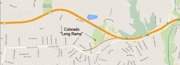 In
October 2015, the "Lets Go LA" blog proposed removal of the long ramps
from Colorado to Route 134. Although that removal is unlikely, the blog
provided a pointer to an interesting historical discussion. These ramps
are leftovers from an early interim terminus of Route 134, when the state
planned to run the freeway through Eagle Rock rather than the through the
hills above it. In the 1950s, plans to complete Route 134 Freeway (then
referred to as the Colorado Boulevard Freeway) started to take shape. At
this point, the freeway portion of Route 134 already ran through Burbank
and Pasadena, but it did not yet go through Glendale or Eagle Rock.
In
October 2015, the "Lets Go LA" blog proposed removal of the long ramps
from Colorado to Route 134. Although that removal is unlikely, the blog
provided a pointer to an interesting historical discussion. These ramps
are leftovers from an early interim terminus of Route 134, when the state
planned to run the freeway through Eagle Rock rather than the through the
hills above it. In the 1950s, plans to complete Route 134 Freeway (then
referred to as the Colorado Boulevard Freeway) started to take shape. At
this point, the freeway portion of Route 134 already ran through Burbank
and Pasadena, but it did not yet go through Glendale or Eagle Rock.
(Source: LetsGoLA: Freeway Removal at the 134, 10/13/2015)
Initially, there were a few routing configurations being considered for
the portion through Eagle Rock. One proposal had the freeway running south
of Colorado Boulevard along Chickasaw Avenue, while the other two placed
the freeway north of the boulevard, with one along Las Flores Drive and
the other on Hill Drive. These routes were immediately opposed by a
substantial portion of the neighborhood, including local elected officials
and the Chamber of Commerce. In 1960, a group of residents formally
organized the “Northeast Skyway League” to fully advocate for
routing Route 134 as far north into the hills as possible. The Skyway
League argued a freeway in the hills would provide a more pleasant and
scenic experience.Highway engineers criticized the Skyway League’s
proposal, telling the community that a route far up into the ridge of
local foothills would cost $15 million more than the engineer-favored
routes and that the Skyway League’s route would not provide
sufficient service. Despite pushback from engineers, Assemblymember John
Collier defended the Skyway League’s proposed route in the
foothills. By 1960, to the delight of the North Eagle Rock
Homeowner’s Association, the state highway engineers formally
favored routing Route 134 along Las Flores, which was planned to have two
access points for on- and off-ramps. The engineers claimed this route
would provide the best service, be the cheapest to construct and afford
the most benefits to the community. This route would require nearly 400
homes be removed to build the freeway. The Skyway League’s route, by
comparison, would only require the removal of 12 homes and the
organization insisted no on- or off-ramps were necessary in Eagle Rock
because Colorado Boulevard could provide all the access people need.
Additionally, the Eagle Rock Citizens Protective League preferred a route
just north of Hill Drive. This route was estimated to require the removal
of about 150 homes and was considered to be a compromise between the
Homeowners’ Association and Skyway League. Lastly, the Eagle Rock
Freeway Association opposed any freeway through Eagle Rock but would favor
a route south of Colorado Boulevard if a freeway was deemed absolutely
necessary. Shortly after the Freeway Association entered the discussion,
the Highway Commission picked the route preferred by the Citizens
Protective League. At this point, the Skyway League dropped its opposition
due to fear that further discussion might lead the Highway Commission to
change its decision and go with a more southerly route. The Skyway League
urged Assemblymember Collier to adopt their view, which he did. However,
the Freeway Association continued their fight, arguing that the mile-long
freeway connector in Eagle Rock to the already-built portion of the
freeway would be abandoned if a route north of Colorado Boulevard were
built. Highway officials countered that the freeway stub would become an
on- and off-ramp. Additionally, in 1964 plans for an on- and off-ramp at
Eagle Rock Boulevard were discarded. The freeway was also built to go
around Eagle Rock Park, rather than through it.
(Source: Walk Eagle Rock: Eagle Rock's Freeway Revolt, 3/23/2015; LetsGoLA:Freeway
Removal at the 134, 10/13/2015)
 Pre 1964 Signage History
The surface routing of Route 134 was LRN 161, defined in 1933. LRN 161 ran along Colorado Blvd. The later freeway routing was LRN 240, defined in 1957. This route was signed by 1935, but was not one of the original signed routes in 1934. Between US 101 and US 99, the route ran along Lankersheim, Riverside, and Alameda Avenue, then down San Fernando Road (cosigned with US 99) to Colorado Blvd.
On December 13, 1913, Pasadena’s Colorado Street Bridge was
dedicated. More than 3,000 local residents turned out for the
ceremonies.The structure was replaced by the Arroyo Seco Bridge in 1951 as
part of the Colorado Freeway in Pasadena.
(Source: Metro Library: This Day in Los Angeles Transportation History, 12/13/2018)
An August 1941 report issued by the Regional Planning Commission of Los
Angeles County entitled “A Report on the Feasibility of a Freeway
Along the Channel of the Los Angeles River” proposed a
four-lane roadway on each levee from Anaheim Street in Long Beach north to
Sepulveda Boulevard in the San Fernando Valley; excepting between Soto
Street and Dayton Street in downtown Los Angeles, where, due to a lack of
right-of-way along the river, the alignment matches the future alignment
of the US 101 portion of the Santa Ana Freeway. There is no mention in the
report of a master plan of freeways like that issued in 1947, although the
maps showed connections to the already-completed Arroyo Seco Parkway and
the proposed Ramona and Rio Hondo Parkways.
(Thanks to Daniel Thomas for hunting down this
information)
On 11/18/1954, the CHC adopted a 10.9 mi route for the Riverside-Ventura freeway extending from the junction with US 99, the Golden State Freeway, westerly to Sepulveda Blvd.
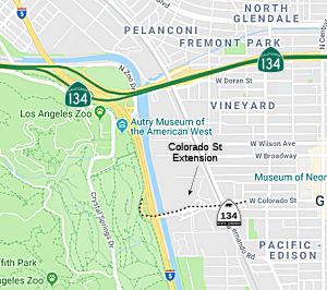
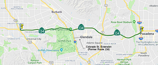
Colorado Street Extension (Route 5S)
The Colorado Street Freeway Extension (Route 5S) opened
in 1958 as the Golden State Freeway (then US 99, US 6 and I-5) was being
constructed. The Colorado Freeway Extension would serve as a
temporary realignment of US 99/US 6 off of San Fernando Road and new
alignment of Sign Route 134. US 99 and US 6 followed the Colorado
Street Freeway Extension to San Fernando Road until the Golden State
Freeway was completed to the San Bernardino Freeway in 1962. The
Colorado Street Freeway Extension would be assigned as part of the
original 1964 incarnation of Route 163, but was quickly folded into a
Route 134 Spur by 1965. The corridor would be assigned as part of
Route 5S when the Ventura Freeway extension reached Route 2 (then at
Verdugo Road) in 1969. Note: The Colorado
Street Extension is a formally suffixed route in the Postmile System
(Route 5S), as opposed to having "S" postmiles (i.e., 07-LA-005 S0.0).
(Source: Gribblenation Blog (Tom Fearer), "The Colorado Street Freeway Extension (Interstate 5 Spur in Glendale and Los Angeles)", 2/2024)
As originally defined, Colorado Street ended at San
Fernando Road (US 99 / LRN 4) in the city Glendale. Colorado Street
became a component of LRN 161 in 1933 after the state began to allow the
Division of Highways to maintain State Highways in incorporated
cities. When sign routes were announced in 1934, Sign Route 134 westbound followed a multiplex of US 99/LRN 4 on San Fernando Road
from the end of Colorado Street in Glendale to Alameda Avenue in Burbank.
US 99 along San Fernando Road would be joined by an extended US 6
beginning in 1937. In 1955, construction began on the Golden State Freeway
corridor between the Santa Ana Freeway and Hollywood Freeway; this would
be an eventual rerouting of US 99/US 6/LRN 4, and the route would take it
through the cities of Glendale and Burbank. By 1958, the Colorado
Boulevard Interchange was under construction to connect Sign Route 134 via
LRN 4 to US 99/US 6 on the Golden State Freeway over the Los Angeles River
extending it from San Fernando Road in Glendale. By 1959, the Golden State
Freeway was completed between Alameda Avenue in Burbank south to Glendale
Boulevard in Los Angeles. US 99/US 6 followed an interim alignment on LRN 4 originating at San Fernando Road in Burbank, west on Alameda Avenue,
south on the Golden State Freeway and east on the Colorado Street Freeway
Extension to San Fernando Road in Glendale. Route 134 followed an
interim multiplex of US 99/US 6/LRN 4 on the Golden State Freeway between
Colorado Street north to Alameda Avenue. South of Colorado Boulevard
to Glendale Street, the Golden State Freeway was part of LRN 161. The
completion of the Golden State Freeway from Lankershim Boulevard to the
Santa Ana Freeway in 1962 resulted in the realignment of US 99 to follow
I-5/LRN 4 on the Golden State Freeway directly to the San Bernardino
Freeway, bypassing the Pasadena Freeway and Santa Ana Freeway through
downtown Los Angeles. At this time, the Colorado Street Freeway
Extension was a spur of LRN 4 and solely signed as Route 134. This
segment became part of Route 163, only to go away in 1965 when it became a
spur of Route 134. With the completion of the Ventura Freeway Extension
from I-5 east to Route 2 at Verdugo Road in 1969, Route 134 was rerouted
off of Colorado Street in downtown Glendale north on Route 2/Verdugo Road
to the new segment of the Ventura Freeway. The Colorado Street
Freeway Extension was renumbered as Route 5S (note: it is not I-5S, as it
was never a formal part of the Interstate system)
(Source: Gribblenation Blog (Tom Fearer), "The Colorado Street Freeway Extension (Interstate 5 Spur in Glendale and Los Angeles)", 2/2024)
A portion of Route 134 was constructed to freeway standards well before the current routing between I-5 and Route 210. This "quasi-freeway", called the Colorado Street Extension, now exists as a long on-ramp/off-ramp to I-5 near the LA Zoo. Michael Ballard writes this about the extension on his page on "Unsigned Colorado Freeway":
In 1955, the freeway was extended further west from Avenue 64 to Colorado Blvd at Eagle Vista Drive. In 1957, the Golden State Freeway was also extended from Western Avenue in Burbank to Los Feliz Blvd in Glendale. Along with many other interchanges, a freeway-grade exit to Colorado Street was built. This is known as the Colorado Street Freeway Extension and was signed as Route 134.
In 1971, the eastern Colorado Freeway was rebuilt to higher standards. It was widened, repaved, and realigned. It was also renamed the Ventura Freeway. Part of the old Colorado Freeway still exists, however, as the westbound Colorado Blvd exit. The western segment of the freeway still exists almost unmodified and still remains in heavy use. While it is no longer signed, the western segment still remains as a part of Route 134 (to be precise, it is Route 5S, LA 25.694 to LA 25.157). One aspect of the western segment is rather unique. It remained as the last freeway in Los Angeles with an intact raised median with no barrier until recently. The median was upgraded to a standard style median in 2016.
The Colorado Street Extension became Route 163 in 1964 between I-5 and San Fernando Road; Route 163 was deleted in 1965 (which explains why it became Route 5S instead of Route 134S).
 Status
Although the legislative definition indicates this route ends at I-210, one correspondent (DW) has noted that there is a sign on Colorado Blvd indicating that the eastern terminus is at Arroyo Parkway and Route 110. By early 2000, this sign appeared to be gone. Further, there appear to be other portions of Colorado Street that are still signed as Route 134 (in particular, from I-5 to east of San Fernando Road). Again, by early 2000, this signage was gone.
In late April 2007, a project was begun to add an onramp to westbound Route 134 near the media center in Burbank (~ LA 2.341) in order to improve traffic flow in a heavily traveled area. The $47-million onramp will give drivers access to westbound Route 134 from Alameda Avenue, just east of Hollywood Way. Burbank transportation officials realigned the Hollywood Way off-ramp from westbound Route 134 in order to make room for the addition. The existing ramp at the northwest corner of Hollywood Way and Alameda will remain in place. This new ramp opened at the end of April 2011. The new configuration eliminated a left turn that backed up traffic during peak times for a corridor that accommodates hundreds of workers for Disney, Warner Bros., Providence St. Joseph Medical Center and NBC. Previously, motorists heading north on Alameda Avenue had to cross traffic to turn onto the Alameda on-ramp. Now, instead of turning left, motorists can continue north and turn right onto the new Hollywood Way on-ramp. The ramp curves around a power station and merges with the existing Alameda on-ramp The project also included the lengthening of freeway overcrossings on Alameda and Pass avenues, as well as Hollywood Way.
There appear to be plans for a study to improve the I-5/Route 134 interchange (~ LA 3.973 to LA R5.72) (March 2001 CTC Agenda). This study should be complete in early 2001; it is District 7 TCRP Project #154. It plans to explore completing the "back moves", i.e., from Eastbound Route 134 to Northbound I-5, and from Southbound I-5 to Westbound Route 134.
Glendale Cap Park (~ LA R6.959 to LA R7.862)
 In March 2013, it was reported that Glendale has received an initial concept presentation exploring the idea of capping Route 134 to
create park space between Central and Glendale Avenue, similar to
Seattle's Freeway Park, Boston's Rose Kennedy Greenway and the proposed
park over US 101 in Hollywood. The funding to explore the idea came from a
grant front the Southern California Association of Governments, and has
been led Glendale's mobility planner Mike Nilsson in conjuction with
planning and urban design consultants Melendrez.
In March 2013, it was reported that Glendale has received an initial concept presentation exploring the idea of capping Route 134 to
create park space between Central and Glendale Avenue, similar to
Seattle's Freeway Park, Boston's Rose Kennedy Greenway and the proposed
park over US 101 in Hollywood. The funding to explore the idea came from a
grant front the Southern California Association of Governments, and has
been led Glendale's mobility planner Mike Nilsson in conjuction with
planning and urban design consultants Melendrez.
(Source: Tropico Station Blog)
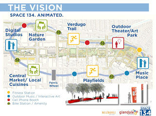
The product to cover Route 134 has continued to have
momentum into 2015. The project is now called Space 134. According to their website, the Glendale "Space 134" project is a concept study for a "freeway cap park" over Route 134 from Central
Avenue to Glendale Avenue. The freeway cap park would connect the
community to the City's civic, cultural, and business core through public
open space and pedestrian and bike friendly trails. The intial concept
phase is entirely funded by the Southern California Association of
Governments (SCAG) through their Compass Blueprint Grant which was awarded
to the City of Glendale in 2012. The Near-Term Phase includes improvements
to existing bridges, incorporation of public art and adding pedestrian
lighting to roads & bridges. The Mid-Term Phase explores partially
capping Route 134 in certain sections between Central Avenue and Glendale
Avenue. The long-term vision for the cap imagines the potential for over
20 acres of open space, including a convention and events center, transit
facilities, active sports facilities, passive open space and a potential
reconfiguration of existing retail centers. They held a community workshop
on the plan in October 2015.
(Source: Emory at Aaroads, Space 134)
In March 2016, it was reported that updated renderings
of the Route 134 Cap Park are finally really starting to take shape. They
show what the 24-acre green space could look like, and give a better idea
of how the park will be laid out. Working with the firm Melendrez,
Glendale officials have created a concept plan that has the park set up as
a kind of link between Glendale's downtown area and its residential
neighbors to the east. The segment of the park between Central Avenue and
Louise would be oriented toward downtown, and would include a restaurant,
a mobility hub with bike parking and rental facilities, and transit
connections. From Louise east to Balboa, in the more residential areas,
there would be a playground, community centers, and sports courts. There
would be three event spaces, but the one in the downtown section could
handle large-scale events like festivals. Much-desired walking trails will
run the length of the cap park. The cap park will eventually extend for a
.7-mile length of the freeway between Central and Balboa avenues, but will
be built in phases, with the first phase to be built between Central
Avenue and Brand Boulevard. Glendale's planning on private and public
funding sources to help pay for the cap park, which it hopes to start
construction on after 2020. Images and such may be found in the linked
source article.
(Source: Curbed LA, 3/7/2016)
Reconfiguration of Colorado Blvd in Eagle Rock (~ 134 LA 9.693 to LA 11.188)
Although not directly on Route 134, in April 2021 it
was reported that LA Metro is pushing for a bus rapid transit (BRT) route
through Eagle Rock that would reduce Colorado Boulevard to one car lane
each way between Eagle Rock Boulevard and Linda Rosa Avenue (paralleling
134 LA R9.693 to LA R11.188, roughly where the on-ramp to EB Route 134
comes off Colorado). The car-lane reduction would create room for
dedicated bus lanes and enhanced bike lanes, while preserving most
on-street parking. There are a number of options being discussion.
Subsequent discussion of this item on AAroads noted that one reason for
this is the traffic from Route 134 in the area that diverts to surface
streets when the freeway is jammed.
(Source: Boulevard Sentinel, 3/30/2021)
In May 2021, it was reported that Los Angeles City
Councilmember Kevin de León has called on Metro to delay moving
forward with its proposal for a bus rapid transit (BRT) route in Eagle
Rock that would reduce much of Colorado Boulevard to one car lane each
way. De León said a delay was needed because Metro had pushed
ahead with the one-car-lane-each-way proposal without presenting a full
picture of the plan to Eagle Rockers and adequately soliciting their
feedback. De León also wrote that Metro needed to take the time to
develop a route option for Colorado Boulevard that attempts to preserve
two car lanes each way and safe bike lanes, without eliminating the
medians and curb extensions. Metro should then hold public meetings where
both the one-car-lane proposal and the two-car-lane proposal are presented
so that Eagle Rockers can weigh the options and provide feedback. As a
result, at its mid May meeting on the proposed North Hollywood-to-Pasadena
bus rapid transit line, the Metro Board Planning and Programming committee
unanimously approved a staff recommendation to advance two potential
design options for Colorado Boulevard in Eagle Rock to the project’s
next planning stage. One of the design options would reduce Colorado
Boulevard to one car lane each way, affecting traffic; the other would
retain two car lanes each way, affecting curbside parking and/or the
median. Both options would establish dedicated bus lanes on the boulevard
and maintain the boulevard’s buffered bike lanes. An earlier option
by Metro that retained two car lanes each way, retained parking, preserved
the medians and created dedicated bus lanes has apparently fallen out of
the mix. That option met stiff opposition from bicycle advocates because
it would have converted the boulevard’s bike lanes to a shared lane
for use by bicycles and buses.
(Source: Boulevard Sentinel, 5/13/2021; Boulevard Sentinel, 5/19/2021)
Arroyo Seco Bridge (~ LA R12.54)
In July 2016, the LA Times reported on a design
proposal to remake the Route 134 Arroyo Seco bridge near the intersection
with Route 210 in Pasadena. This proposal comes from Michael Maltzan
Architecture, a Los Angeles firm best known for the One Santa Fe apartment
complex in the Arts District, the Star Apartments near Skid Row and the
forthcoming Sixth Street Viaduct spanning the Los Angeles River. The
proposal would wrap the freeway bridge, built in 1953 and expanded in
1971, inside a sort of tunnel, what Maltzan describes as a “new
infrastructural overlay” stretching nearly three-quarters of a mile.
The overlay would include acoustically insulated walls capable of reducing
traffic noise, which has a severe effect up and down the Arroyo and
throughout this part of Pasadena, by 65%. A perforated aluminum ceiling
would direct auto emissions through concrete “lungs” made of
precast concrete treated with titanium dioxide, capturing 516,000 tons of
carbon dioxide per year. Transparent polycarbonate panels at eye level
would maintain views from the freeway bridge for drivers and passengers;
according to Maltzan the plan is “a design solution that celebrates
the experience of driving over the Arroyo Seco while sustainably
integrating the freeway into its immediate context.” The new
structure would collect rainwater, storing it in a pair of drums big
enough to hold 750,000 gallons each. Some of that water would be used to
maintain hanging plants on the exterior of the tunnel. The rest — as
much as 5 million gallons per year — would be added to the city of
Pasadena water supply. A field of photovoltaic panels along the top of the
tunnel would produce about 6 million kilowatt-hours of electricity
annually — enough to power 600 homes. To be approved and built, the
plan would require cooperation among the city of Pasadena, Los Angeles
County and Caltrans.
(Source: LA Times, 7/7/2016)
In July 2017, there was a discussion about the
increasing number of suicides from the Arroyo Seco Bridge. There’s a
long history of jumpers since the 1930s, with dozens of deaths during the
Great Depression. And a recent surge has city officials scrambling to put
up temporary barriers while deciding on permanent solutions. The latest
records show six deaths in four months between March and July 2017. Work
crews have installed poles that will later have mesh stretched across them
to block access to 20 pedestrian alcoves on the bridge, making it harder
to jump the fence. Additionally, a Pasadena City Council committee will
review a staff report on possible long-term fixes, along with details on
what other cities — including San Francisco — have done to
thwart suicides from bridges. The proposals include full-time bridge
patrols, higher fencing and netting draped under the bridge.
(Source: LA Times, 7/19/2017)
 Commuter Lanes
Commuter lanes exist on this route for its entire length. The portion from the US 101/Route 170 interchange to Route 2 was opened in April 1996; the remainder in May 1996. They require two or more occupants, and are in operation 24 hours a day.
 Naming
 The portion of this route from Route 101 near Riverside Drive (the
Route 170 junction) to Route 5 (~ LA 0.055 to LA 5.041R) is named the "Ventura
Freeway". It was named by a Senate Concurrent Resolution in 1973.
The portion of this route from Route 101 near Riverside Drive (the
Route 170 junction) to Route 5 (~ LA 0.055 to LA 5.041R) is named the "Ventura
Freeway". It was named by a Senate Concurrent Resolution in 1973.
(Image source: AARoads)
 The interchange of the U 101, Route 134, and Route 170 freeways (~ 134 LA 0.000) is named the "Bruce
T. Hinman Memorial Interchange." Officer Bruce T. Hinman was on
routine motorcycle patrol on Route 170 at US 101 when he stopped to assist
a disabled motorist. A drunk driver traveling at 60 m.p.h. along US 101
attempted to change routes by driving over a raised berm, then across the
freeway and onto the dirt shoulder where he crashed into the disabled
vehicle. The impact spun the disabled vehicle around, striking the
motorist, who was using the freeway call box, and knocking Officer Hinman
to the ground. The car came to rest with its rear wheels on top of the
officer's chest, suffocating him. Officer Hinman, 34, was placed on life
support but died a week later. He was a nine-year member of the CHP and
was assigned to the West Valley Area office directly after graduating from
the Academy. CHP Officer Bruce Hinman, an eight-year CHP veteran, was said
to be the first officer in the 26-year history of the patrol's West Valley
station to die in the line of duty.
The interchange of the U 101, Route 134, and Route 170 freeways (~ 134 LA 0.000) is named the "Bruce
T. Hinman Memorial Interchange." Officer Bruce T. Hinman was on
routine motorcycle patrol on Route 170 at US 101 when he stopped to assist
a disabled motorist. A drunk driver traveling at 60 m.p.h. along US 101
attempted to change routes by driving over a raised berm, then across the
freeway and onto the dirt shoulder where he crashed into the disabled
vehicle. The impact spun the disabled vehicle around, striking the
motorist, who was using the freeway call box, and knocking Officer Hinman
to the ground. The car came to rest with its rear wheels on top of the
officer's chest, suffocating him. Officer Hinman, 34, was placed on life
support but died a week later. He was a nine-year member of the CHP and
was assigned to the West Valley Area office directly after graduating from
the Academy. CHP Officer Bruce Hinman, an eight-year CHP veteran, was said
to be the first officer in the 26-year history of the patrol's West Valley
station to die in the line of duty.
(Image source: Flikr, Officer Down Memorial Page)
 The portion of US 101 between the Laurel Canyon Boulevard
exit on US 101 and the interchange with Route 134 (~ LA 11.866R to LA
12.88) and portion of Route 134 from the interchange with US 101 to the
North Pass Avenue exit on Route 134 (~ LA 0.000 to LA 1.798) in the County
of Los Angeles is named the “Amelia Earhart Memorial Highway”.
It was named in memory of Amelia Earhart, who was born on July 24, 1897,
in Atchison, Kansas. After graduating from Hyde Park High School in 1915,
Earhart attended Ogontz, a girl’s finishing school in the suburbs of
Philadelphia. Earhart left Ogantz in the middle of her second year to work
as a nurse’s aide in a military hospital in Canada during World War
I, attended college, and later became a social worker at Denison House, a
settlement house in Boston. Earhart took her first flying lesson on
January 3, 1921, and, in six months, managed to save enough money to buy
her first plane, a second-hand Kinner Airster two-seater biplane painted
bright yellow, which she named “The Canary,” and used to set
her first women’s record by rising to an altitude of 14,000 feet. In
1928, Earhart was asked to join pilot Wilmer “Bill” Stultz and
copilot and mechanic Louis E. “Slim” Gordon as part of a
project to be the first woman to fly across the Atlantic Ocean. On June
17, 1928, the team left Trepassey Harbor, Newfoundland, in a Fokker F7
named Friendship, and arrived at Burry Port, Wales approximately 21 hours
later. Their landmark flight made headlines worldwide because three pilots
had died within the year trying to be the first woman to fly across the
Atlantic. When the crew returned to the United States, they were greeted
with a ticker-tape parade in New York and a reception held by President
Calvin Coolidge at the White House. Earhart and George Putnam, a book
publisher and publicist, developed a friendship during preparation for the
Atlantic crossing and were married on February 7, 1931. Intent on
retaining her independence, she referred to the marriage as a
“partnership” with “dual control”. Together,
Earhart and Putnam worked on secret plans for Earhart to become the first
woman and the second person to fly solo across the Atlantic and on May 20,
1932, five years to the day after the Lindbergh flight across the
Atlantic, she took off from Harbor Grace, Newfoundland, to Paris; alas
strong north winds, icy conditions, and mechanical problems plagued the
flight and forced her to land in a pasture near Londonderry, Ireland. As
word of her flight spread, the media surrounded her, both overseas and in
the United States. President Herbert Hoover presented Earhart with a gold
medal from the National Geographic Society and Congress awarded her the
Distinguished Flying Cross-the first ever given to a woman. At the
ceremony, Vice President Charles Curtis praised her courage, saying she
displayed “heroic courage and skill as a navigator at the risk of
her life”. Earhart felt the flight proved that men and women were
equal in “jobs requiring intelligence, coordination, speed,
coolness, and willpower”. In the years that followed, Earhart
continued to reach new heights, setting an altitude record for autogyros
of 18,415 feet that stood for years and on January 11, 1935, she became
the first person to fly solo across the Pacific Ocean from Honolulu to
Oakland, California. In 1937, as Earhart neared her 40th birthday, she was
ready for a monumental, and final, challenge: she wanted to be the first
woman to fly around the world. On June 1, 1937, Earhart and her navigator,
Fred Noonan, departed from Miami and began the 29,000-mile journey around
the world and by June 29, when they landed in Lae, New Guinea, all but
7,000 miles had been completed. On July 2, 1937, the pair embarked on a
2,556 mile flight from Lae, New Guinea to Howland Island. During this
flight they encountered difficult conditions for navigation and Earhart
lost radio contact the following morning with a nearby United States Coast
Guard ship. Earhart’s plane disappeared and nothing further was
heard from her. The world will always remember Amelia Earhart for her
courage, vision, and groundbreaking achievements, both in aviation and for
women. In a letter to her husband, written in case a dangerous flight
proved to be her last, her brave spirit was clear. “Please know I am
quite aware of the hazards,” she said. “I want to do it
because I want to do it. Women must try to do things as men have tried.
When they fail, their failure must be but a challenge to others”.
Named by Assembly Resolution ACR 79, Res. Chapter 121, 08/19/22.
The portion of US 101 between the Laurel Canyon Boulevard
exit on US 101 and the interchange with Route 134 (~ LA 11.866R to LA
12.88) and portion of Route 134 from the interchange with US 101 to the
North Pass Avenue exit on Route 134 (~ LA 0.000 to LA 1.798) in the County
of Los Angeles is named the “Amelia Earhart Memorial Highway”.
It was named in memory of Amelia Earhart, who was born on July 24, 1897,
in Atchison, Kansas. After graduating from Hyde Park High School in 1915,
Earhart attended Ogontz, a girl’s finishing school in the suburbs of
Philadelphia. Earhart left Ogantz in the middle of her second year to work
as a nurse’s aide in a military hospital in Canada during World War
I, attended college, and later became a social worker at Denison House, a
settlement house in Boston. Earhart took her first flying lesson on
January 3, 1921, and, in six months, managed to save enough money to buy
her first plane, a second-hand Kinner Airster two-seater biplane painted
bright yellow, which she named “The Canary,” and used to set
her first women’s record by rising to an altitude of 14,000 feet. In
1928, Earhart was asked to join pilot Wilmer “Bill” Stultz and
copilot and mechanic Louis E. “Slim” Gordon as part of a
project to be the first woman to fly across the Atlantic Ocean. On June
17, 1928, the team left Trepassey Harbor, Newfoundland, in a Fokker F7
named Friendship, and arrived at Burry Port, Wales approximately 21 hours
later. Their landmark flight made headlines worldwide because three pilots
had died within the year trying to be the first woman to fly across the
Atlantic. When the crew returned to the United States, they were greeted
with a ticker-tape parade in New York and a reception held by President
Calvin Coolidge at the White House. Earhart and George Putnam, a book
publisher and publicist, developed a friendship during preparation for the
Atlantic crossing and were married on February 7, 1931. Intent on
retaining her independence, she referred to the marriage as a
“partnership” with “dual control”. Together,
Earhart and Putnam worked on secret plans for Earhart to become the first
woman and the second person to fly solo across the Atlantic and on May 20,
1932, five years to the day after the Lindbergh flight across the
Atlantic, she took off from Harbor Grace, Newfoundland, to Paris; alas
strong north winds, icy conditions, and mechanical problems plagued the
flight and forced her to land in a pasture near Londonderry, Ireland. As
word of her flight spread, the media surrounded her, both overseas and in
the United States. President Herbert Hoover presented Earhart with a gold
medal from the National Geographic Society and Congress awarded her the
Distinguished Flying Cross-the first ever given to a woman. At the
ceremony, Vice President Charles Curtis praised her courage, saying she
displayed “heroic courage and skill as a navigator at the risk of
her life”. Earhart felt the flight proved that men and women were
equal in “jobs requiring intelligence, coordination, speed,
coolness, and willpower”. In the years that followed, Earhart
continued to reach new heights, setting an altitude record for autogyros
of 18,415 feet that stood for years and on January 11, 1935, she became
the first person to fly solo across the Pacific Ocean from Honolulu to
Oakland, California. In 1937, as Earhart neared her 40th birthday, she was
ready for a monumental, and final, challenge: she wanted to be the first
woman to fly around the world. On June 1, 1937, Earhart and her navigator,
Fred Noonan, departed from Miami and began the 29,000-mile journey around
the world and by June 29, when they landed in Lae, New Guinea, all but
7,000 miles had been completed. On July 2, 1937, the pair embarked on a
2,556 mile flight from Lae, New Guinea to Howland Island. During this
flight they encountered difficult conditions for navigation and Earhart
lost radio contact the following morning with a nearby United States Coast
Guard ship. Earhart’s plane disappeared and nothing further was
heard from her. The world will always remember Amelia Earhart for her
courage, vision, and groundbreaking achievements, both in aviation and for
women. In a letter to her husband, written in case a dangerous flight
proved to be her last, her brave spirit was clear. “Please know I am
quite aware of the hazards,” she said. “I want to do it
because I want to do it. Women must try to do things as men have tried.
When they fail, their failure must be but a challenge to others”.
Named by Assembly Resolution ACR 79, Res. Chapter 121, 08/19/22.
(Image source: Wikipedia)
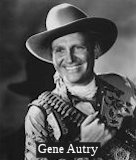 The I-5/Route 134 interchange (~ LA
5.041R) is named the "Gene Autry Memorial Interchange". Gene Autry was best known as a singing cowboy of stage and screen. Wikipedia says the following about Autry: Orvon Grover "Gene" Autry (September 29,
1907 – October 2, 1998), nicknamed The Singing Cowboy, was an
American singer, songwriter, actor, musician and rodeo performer who
gained fame largely by singing in a crooning style on radio, in films, and
on television for more than three decades beginning in the early 1930s.
Autry was the owner of a television station (KTLA), several radio stations
(KSFO, KMPC, KOGO), and the Los Angeles/California/Anaheim Angels Major
League Baseball team from 1961 to 1997. From 1934 to 1953, Autry appeared
in 93 films, and between 1950 and 1956 hosted The Gene Autry Show
television series. During the 1930s and 1940s, he personified the
straight-shooting hero—honest, brave, and true—and profoundly
touched the lives of millions of Americans. Autry was also one of the most
important pioneering figures in the history of country music, considered
the second major influential artist of the genre's development after
Jimmie Rodgers. His singing cowboy films were the first vehicle to carry
country music to a national audience. In addition to his signature song,
"Back in the Saddle Again", and his hit "At Mail Call Today", Autry is
still remembered for his Christmas holiday songs, most especially his
biggest hit "Rudolph, the Red-Nosed Reindeer" as well as "Frosty the
Snowman", "Here Comes Santa Claus", and "Up on the House Top". Autry is
responsible for the creation of the "Cowboy Code" of behavior. Autry is a
member of both the Country Music Hall of Fame and Nashville Songwriters
Hall of Fame, and is the only person to be awarded stars in all five
categories on the Hollywood Walk of Fame, for film, television, music,
radio, and live performance. The named interchange is near the Gene Autry
Western Heritage Museum, opened in 1988. Named by SCR 17, Resolution
Chapter 61, on July 16, 1999.
The I-5/Route 134 interchange (~ LA
5.041R) is named the "Gene Autry Memorial Interchange". Gene Autry was best known as a singing cowboy of stage and screen. Wikipedia says the following about Autry: Orvon Grover "Gene" Autry (September 29,
1907 – October 2, 1998), nicknamed The Singing Cowboy, was an
American singer, songwriter, actor, musician and rodeo performer who
gained fame largely by singing in a crooning style on radio, in films, and
on television for more than three decades beginning in the early 1930s.
Autry was the owner of a television station (KTLA), several radio stations
(KSFO, KMPC, KOGO), and the Los Angeles/California/Anaheim Angels Major
League Baseball team from 1961 to 1997. From 1934 to 1953, Autry appeared
in 93 films, and between 1950 and 1956 hosted The Gene Autry Show
television series. During the 1930s and 1940s, he personified the
straight-shooting hero—honest, brave, and true—and profoundly
touched the lives of millions of Americans. Autry was also one of the most
important pioneering figures in the history of country music, considered
the second major influential artist of the genre's development after
Jimmie Rodgers. His singing cowboy films were the first vehicle to carry
country music to a national audience. In addition to his signature song,
"Back in the Saddle Again", and his hit "At Mail Call Today", Autry is
still remembered for his Christmas holiday songs, most especially his
biggest hit "Rudolph, the Red-Nosed Reindeer" as well as "Frosty the
Snowman", "Here Comes Santa Claus", and "Up on the House Top". Autry is
responsible for the creation of the "Cowboy Code" of behavior. Autry is a
member of both the Country Music Hall of Fame and Nashville Songwriters
Hall of Fame, and is the only person to be awarded stars in all five
categories on the Hollywood Walk of Fame, for film, television, music,
radio, and live performance. The named interchange is near the Gene Autry
Western Heritage Museum, opened in 1988. Named by SCR 17, Resolution
Chapter 61, on July 16, 1999.
(Image Source: Wikipedia)
The portion between Route 5 and Route 2 (~ LA R5.632L to LA R8.891) is unofficially called the "Ventura Freeway".
 The portion between Route 5
and Route 2 (~ LA R5.632L to LA R8.891) is officially named the "Charles
A. Lazzaretto Memorial Freeway". Glendate Police Detective
Lazzaretto was shot and killed while searching for a man suspected of
trying to kill his girlfriend. As they entered a warehouse the suspect
shot at the officers, killing Detective Lazzaretto. Officers returned fire
and surrounded the warehouse during an all night standoff. Two Los Angeles
police officers were shot and injured during the standoff. They both
entered the warehouse in an attempt to rescue Detective Lazzaretto. Both
officers knowingly entered the line of fire in their attempt and in a
result were both shot multiple times, although no shots were life
threatening. The suspect was found dead the next morning after SWAT
entered the warehouse. Named by Assembly Concurrent Resolution 67,
Chapter 97, on 9/3/1999.
The portion between Route 5
and Route 2 (~ LA R5.632L to LA R8.891) is officially named the "Charles
A. Lazzaretto Memorial Freeway". Glendate Police Detective
Lazzaretto was shot and killed while searching for a man suspected of
trying to kill his girlfriend. As they entered a warehouse the suspect
shot at the officers, killing Detective Lazzaretto. Officers returned fire
and surrounded the warehouse during an all night standoff. Two Los Angeles
police officers were shot and injured during the standoff. They both
entered the warehouse in an attempt to rescue Detective Lazzaretto. Both
officers knowingly entered the line of fire in their attempt and in a
result were both shot multiple times, although no shots were life
threatening. The suspect was found dead the next morning after SWAT
entered the warehouse. Named by Assembly Concurrent Resolution 67,
Chapter 97, on 9/3/1999.
(Image source: Officer Down Memorial Page)
Officially, the portion between Route 2 and Route 210 has no name, although it is called the "Ventura" Freeway. But then again....
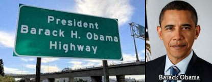 On 9/11/2017, Senate Concurrent Resolution 8, Resolution Chapter 147, named the portion between Route 2 and Route 210 (~ LA R9.08 to LA
R13.193) the "President Barack H. Obama Highway". It was named in
honor of President Barack Obama, the 44th President of the United States.
With a father from Kenya and a mother from Kansas, President Barack
Hussein Obama was born in Hawaii on August 4, 1961. He was raised with
help from his grandfather, who served under General George S. Patton in
the United States Army, and his grandmother, who worked her way up from
the secretarial pool to middle management at a bank. President Obama came
from a middle-class upbringing in a strong family, where hard work and
education were the means of getting ahead, and where the conviction that a
life so blessed should be lived in service to others. President Obama
obtained his early education in Jakarta, Indonesia, and Hawaii and spent
two years at Occidental College in Los Angeles from 1979 to 1981,
inclusive, which played a major role in determining his future. He made
his first political speech there on February 18, 1981, as part of a
movement to persuade the Occidental Board of Trustees to divest the
college of its investments in South Africa. After working his way through
college with the help of scholarships and student loans, President Obama
moved to Chicago, where he worked with a group of churches to help rebuild
communities devastated by the closure of local steel plants. He received a
B.A. in 1983 from Columbia University in New York City and worked as a
community organizer in Chicago, Illinois. He later studied law at Harvard
University, where he became the first African American president of the
Harvard Law Review, and received his J.D. in 1991. Upon graduation from
Harvard Law School, he returned to Chicago to help lead a voter
registration drive, teach constitutional law at the University of Chicago,
and continue his community serviced. President Obama became a State
Senator from Illinois from 1997 to 2004, inclusive, and was elected as a
Democrat to the United States Senate in 2004, and served from January 3,
2005, to November 16, 2008, inclusive. He was elected the 44th President
of the United States on November 4, 2008. After being reelected in 2012,
President Obama completed his second and final term on January 20, 2017.
President Obama and his wife, Michelle, are the proud parents of two
daughters, Malia and Sasha. Signage for the road was installed in December
2018.
On 9/11/2017, Senate Concurrent Resolution 8, Resolution Chapter 147, named the portion between Route 2 and Route 210 (~ LA R9.08 to LA
R13.193) the "President Barack H. Obama Highway". It was named in
honor of President Barack Obama, the 44th President of the United States.
With a father from Kenya and a mother from Kansas, President Barack
Hussein Obama was born in Hawaii on August 4, 1961. He was raised with
help from his grandfather, who served under General George S. Patton in
the United States Army, and his grandmother, who worked her way up from
the secretarial pool to middle management at a bank. President Obama came
from a middle-class upbringing in a strong family, where hard work and
education were the means of getting ahead, and where the conviction that a
life so blessed should be lived in service to others. President Obama
obtained his early education in Jakarta, Indonesia, and Hawaii and spent
two years at Occidental College in Los Angeles from 1979 to 1981,
inclusive, which played a major role in determining his future. He made
his first political speech there on February 18, 1981, as part of a
movement to persuade the Occidental Board of Trustees to divest the
college of its investments in South Africa. After working his way through
college with the help of scholarships and student loans, President Obama
moved to Chicago, where he worked with a group of churches to help rebuild
communities devastated by the closure of local steel plants. He received a
B.A. in 1983 from Columbia University in New York City and worked as a
community organizer in Chicago, Illinois. He later studied law at Harvard
University, where he became the first African American president of the
Harvard Law Review, and received his J.D. in 1991. Upon graduation from
Harvard Law School, he returned to Chicago to help lead a voter
registration drive, teach constitutional law at the University of Chicago,
and continue his community serviced. President Obama became a State
Senator from Illinois from 1997 to 2004, inclusive, and was elected as a
Democrat to the United States Senate in 2004, and served from January 3,
2005, to November 16, 2008, inclusive. He was elected the 44th President
of the United States on November 4, 2008. After being reelected in 2012,
President Obama completed his second and final term on January 20, 2017.
President Obama and his wife, Michelle, are the proud parents of two
daughters, Malia and Sasha. Signage for the road was installed in December
2018.
(Image source: KTLA, 12/20/2018, Biography)
 The segment of the route from former Route 159 (Figueroa Blvd) (134 LA
R11.458) to Orange Grove was named the "Colorado Freeway". It
acquired this name through the route's location, paralleling Colorado
Blvd. It was one of the first freeway segments of future Route 134
constructed (together with the Colorado Stub off of I-5), and predates
determination of the remainder of the Route 134 routing. Image note: The
sign pictured was taken at Figueroa St EB on-ramp near Eagle Rock, which
was later replaced by the new routing to the N. The Route 11 signage
reflects the original routing of Route 11 in 1934: San Pedro to Jct. Route 118 near La Cañada, along Gaffey, Figueroa St, Ave 22, and Linda
Vista to Route 118. The ramp is gone but remaining roadway now part of
long Colorado Blvd off- and on-ramps.
The segment of the route from former Route 159 (Figueroa Blvd) (134 LA
R11.458) to Orange Grove was named the "Colorado Freeway". It
acquired this name through the route's location, paralleling Colorado
Blvd. It was one of the first freeway segments of future Route 134
constructed (together with the Colorado Stub off of I-5), and predates
determination of the remainder of the Route 134 routing. Image note: The
sign pictured was taken at Figueroa St EB on-ramp near Eagle Rock, which
was later replaced by the new routing to the N. The Route 11 signage
reflects the original routing of Route 11 in 1934: San Pedro to Jct. Route 118 near La Cañada, along Gaffey, Figueroa St, Ave 22, and Linda
Vista to Route 118. The ramp is gone but remaining roadway now part of
long Colorado Blvd off- and on-ramps.
(Image source: Post in Freeways of Los Angeles, 7/27/2021, excerpted down to just the naming sign to show proof of naming from an image ©️ California Dept of
Transportation. Full image available at District 7 Archives, 100 S. Main
St, Los Angeles. File No 3485; DOH photographer Sat Yoshizato)
 Named Structures
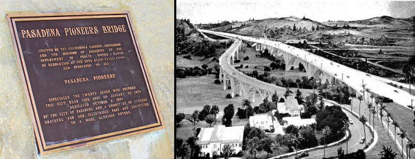 Bridge 53-0166 (LA R012.57), over the Arroyo Seco in Los Angeles county, is named
the "Pioneer, Pasadena Memorial Bridge". It was built in 1953, and
named by Assembly Concurrent Resolution 80, Chapter 182, in the same year.
Pasadena Pioneers' Bridge is named for the party of settlers led by Dr.
T.B. Elliot of Indianapolis, Indiana, who founded the City of Pasadena in
1874. Bids for its construction were let on March 8, 1951. The total
length of the bridge is 1, 366'; the easterly approach viaduct is 215'
long; the westerly viaduct is 372' long. The maximum height of the
structure from the ground to the deck is 130'. Each of the two three-lane
(in 1951) roadways is 40' wide. The total width of the bridge flares out
from a width of 94' at the west end to 168' at the east end. Bridge
construction was expected to cost $3,500,000. It replaced the original
Colorado Street Bridge, built in 1913 by the City of Pasadena and Los
Angeles County. Strict limitations of topography and a deep ravine within
a few hundred feet of the main business section of a city of 100,000
necessitated placing ramps and curves on the deck of a structure whose
size and location would ordinarily dictate the design and planning of the
entire project. The immediate proximity of the 1913 structure make the
selection of type and architectural design more difficult than usual.
Technical design calculations are further complicated by the curvature and
superelevation, excessive width, asymmetry of arch ribs and the magnitude
of the structure. An extensive overview of the planning and engineering of
the new freeway bridge can be found in the January-February, 1951 issue of California Highways and Public Works.
Bridge 53-0166 (LA R012.57), over the Arroyo Seco in Los Angeles county, is named
the "Pioneer, Pasadena Memorial Bridge". It was built in 1953, and
named by Assembly Concurrent Resolution 80, Chapter 182, in the same year.
Pasadena Pioneers' Bridge is named for the party of settlers led by Dr.
T.B. Elliot of Indianapolis, Indiana, who founded the City of Pasadena in
1874. Bids for its construction were let on March 8, 1951. The total
length of the bridge is 1, 366'; the easterly approach viaduct is 215'
long; the westerly viaduct is 372' long. The maximum height of the
structure from the ground to the deck is 130'. Each of the two three-lane
(in 1951) roadways is 40' wide. The total width of the bridge flares out
from a width of 94' at the west end to 168' at the east end. Bridge
construction was expected to cost $3,500,000. It replaced the original
Colorado Street Bridge, built in 1913 by the City of Pasadena and Los
Angeles County. Strict limitations of topography and a deep ravine within
a few hundred feet of the main business section of a city of 100,000
necessitated placing ramps and curves on the deck of a structure whose
size and location would ordinarily dictate the design and planning of the
entire project. The immediate proximity of the 1913 structure make the
selection of type and architectural design more difficult than usual.
Technical design calculations are further complicated by the curvature and
superelevation, excessive width, asymmetry of arch ribs and the magnitude
of the structure. An extensive overview of the planning and engineering of
the new freeway bridge can be found in the January-February, 1951 issue of California Highways and Public Works.
(Image source: CHPW Jan-Feb 1951, Pasadena PIO)
 The original bridge Colorado Street Bridge was built in 1912 and 1913, opening on December 13, 1913. When it was
completed, there were about 35,000 automobiles in all of Los Angeles
County; in 1949 the county's total motor vehicle registration exceeded
1,800,000. The old bridge was added to the State Highway System in 1933.
It no longer appears to be in the state bridge log.
The original bridge Colorado Street Bridge was built in 1912 and 1913, opening on December 13, 1913. When it was
completed, there were about 35,000 automobiles in all of Los Angeles
County; in 1949 the county's total motor vehicle registration exceeded
1,800,000. The old bridge was added to the State Highway System in 1933.
It no longer appears to be in the state bridge log.
(Image source: Wikipedia)
 Classified Landcaped Freeway
The following segments are designated as Classified Landscaped Freeway:
| County | Route | Starting PM | Ending PM |
| Los Angeles | 134 | 0.07 | R13.34 |
 Freeway
[SHC 253.1] Entire route. Added to the Freeway and Expressway system in 1959.
 Exit Information
 Other WWW Links
 National Trails
 This route is part of the De Anza National Historic Trail.
 Statistics
Overall statistics for Route 134:
 Pre-1964 Legislative Route
In 1933, Chapter 767 defined the route from "Corcoran to Lindsay via Tulare" as part of the state highway system. In 1935, this was codified in the highway code as LRN 134, with the definition:
"[LRN 135] at Corcoran to Lindsay via Tulare"
LRN 134 appears to have had an original terminus a quarter mile
approximately west of the modern one at Pickerell Avenue in Corcoran
before LRN 135 was realigned in 1953.
(Source: Gribblenation Blog (Tom Fearer): Route 137)
This definition remained unchanged until the 1963 renumbering. The route
ran from Route 43 at Corcoran to Route 65 at Lindsay via Tulare. This is
present-day Route 137. A small portion was also signed originally as Route 63; specifically, the segment from LRN 4 (US 99) east a short distance to
LRN 132.
(Source: For the portion that was Route 63: Gribblenation Blog (Tom Fearer): Route 137)
© 1996-2020 Daniel P. Faigin.
Maintained by: Daniel P. Faigin
<webmaster@cahighways.org>.
 From Route
  Route 133
 Route 135