
 California Highways:
Click here for a key to the symbols used. An explanation of acronyms may be found at the bottom of the page.
 Routing
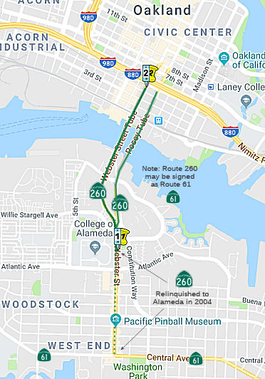 (a) Route 260 is from Route 61 in Alameda to Route 880 in Oakland near Seventh and
Harrison Streets.
(a) Route 260 is from Route 61 in Alameda to Route 880 in Oakland near Seventh and
Harrison Streets.
(b) The relinquished former portion of Route 260 within the City of Alameda between Central Avenue and Atlantic Avenue is not a state highway and is not eligible for adoption under Section 81. For this relinquished former portion of Route 260, the City of Alameda shall maintain within its jurisdiction signs directing motorists to the continuation of Route 260.
 Post 1964 Signage History
In 1965, Chapter 1372 created Route 260 via a transfer from Route 61. The definition was: “Route 61 in Alameda to Route 17 in Oakland near Seventh and Harrison Streets”. That same year, Chapter 1371 reiterated the conditions that had accumulated for the previous legislative version of the route, LRN 226:
“361.1 Upon the completion of the additional subterranean tube between the Cities of Oakland and Alameda, in the vicinity of Webster Street, to be used in connection with the Posey Tube, both of which tubes are included in the description of Route 61, the department may by executive order, rule, or regulation, designate both of said tubes, and the approaches leading to or from the nearest state highway or city street, as one-way highways, and thereafter restrict said tubes and approaches to one-way traffic, proceeding in opposite directions as to each other. Upon the placing of signs notifying the public of such restrictions, any person who wilfully fails to observe such sign is guilty of a misdemeanor.”
“361.2 Because of the statewide interest in navigation, the state will hold and save the United States of America free and harmless from liability for damages to the parallel tubes between the Cities of Oakland and Alameda included in the description of Route 61 due to the initial dredging work and subsequent maintenance dredging in an area within 50 feet of said tubes in connection with the deepening of the Oakland Estuary by the Corps of Engineerings of the United States Army and the Director of Finance shall execute an agreement so to do with the proper representatives of the United States of America.”
In 1968, Chapter 282 renumbered sections 361.1 and 361.2 from Route 61 (§361) to Route 260 (§560), and updated the sections to refer to Route 260.
In 1984, Chapter 409 changed "Route 17" to "Route 880".
On August 30, 2004, AB 2027 was signed. This authorized the California Transportation Commission to relinquish to the City of Alameda the portion of Route 260 that is located within the Alameda city limits that is between Atlantic Avenue and Central Avenue, upon the terms and conditions the commission finds to be in the best interests of the state, if the commission and the city enter into an agreement providing for that relinquishment. The relinquishment becomes effective immediately following the recordation by the county recorder of the relinquishment resolution containing the commission's approval of the terms and conditions of the relinquishment. At that point, the relinquished portion of Route 260 shall cease to be a state highway, and cannot be considered for readoption. Furthermore, the City of Alameda is required to maintain within its jurisdiction signs directing motorists to the continuation of Route 260.
Based on the new bill, in December 2004 the CTC considered relinquishment of a portion of Route 260 right of way in the City of Alameda, between Atlantic Avenue and Central Avenue, under terms and conditions as stated in the cooperative agreement dated May 21, 2004, determined to be in the best interest of the State. Authorized by Chapter 325, Statutes of 2004, which amended Section 560 of the Streets and Highways Code. This appears to have been the work of the West Alameda Business Association (WABA), as reported in San Francisco Bay Crossings. This article talks about the changes to the street now that the highway designation has been dropped:
As a highway, the street had to be as wide as possible and well lit, leaving darkened narrow sidewalks. Sidewalks are being widened, and sidewalk furniture will be installed along with much-anticipated Acorn Street Lights. The old trees have been removed, and they will soon be replaced by a variety of flowering trees. Putting utilities underground will also improve the look of the street, making it a lovely street for strolling. Buses run regularly along the street, and the ferry is close by.
In 2010, Chapter 421, SB 1318, 9/29/10, changed the start of the route: "Route 61 Atlantic Avenue in Alameda to ..."
 Pre 1964 Signage History
Originally, this route was part of LRN 69, defined in 1933 (and signed as part of Sign Route 17). In 1947, LRN 69 was rerouted to the Nimitz Freeway routing, and "LRN 252" was extended through the addition of “the highway from San Leandro to Oakland via Alameda and the Posey Tube” (which “is part of [LRN 252]”). In 1949, the legislature realized their mistake, and added the LRN 252 segment to LRN 226. This made LRN 226:
Segment 1 (later reworded as being from LRN 105 (unsigned Route 13, Fourteenth Street) in San Leandro to LRN 69 (Route 17; present-day I-880) in Oakland near Seventh and Harrison Streets via Alameda and the vicinity of the Oakland International Airport) became Route 260, Route 61, and Route 112, although it wasn't signed between 1947 and 1964. Segment 2 (later reworded to be from LRN 69 (Route 17; present-day I-880) near Castro Street in Oakland to LRN 5 (US 50; present-day I-580)) became I-980.
Webster Street Bridge ⇒ Jibboon Street Bridge
The Webster Street Bridge structure across the Oakland
Estuary was erected in January 1926, a component of the Webster Street
Bridge between Oakland and Alameda. This structure replaced a
similar Pratt Truss swing structure that had been damaged by a ship impact
in late 1925. The prior Pratt Truss at Oakland Estuary and the rest of the
Webster Street Bridge was constructed in 1898.
(Source: Gribblenation Blog (Tom Fearer), "The Jibboom Street Bridge (former California State Routes 24, 70 and 99 at the American River)", 10/30/2025)
Before the Posey and Webster tubes were built, there
were two small swing bridges between Oakland and Alameda for trains and
automobile traffic. After the turn of the century, these bridges were
struggling to bear the increase in commercial rail traffic and
encountering conflicts with ships. Located on Webster and Alice streets,
they opened 12 times a day in 1900. By 1906 that number had increased to
60. The Webster bridge was later incorporated into Sacramento’s
Jibboom Street Bridge (which was part of Sign Route 24). Built in 1928,
the Posey Tube solved that problem. Engineered by George Posey, the Posey
Tube was the widest in the world and it was built using an innovative
method. Most tunnels back then were constructed from a steel shell later
filled with concrete. To build the Posey Tube, construction crews floated
concrete tunnel pieces on a barge in the estuary to precise locations
before sinking and connecting them. Only London, New York, and
Philadelphia had large tunnels built this way back then. The portals were
designed by architect Henry Meyers, who’s known for designing
Highland Hospital, the Veterans Memorial Building, and the Caldecott
Tunnel as well. The quintessential Art Deco Oakland portal structure was
kind of an influencer of this area. The parallel Webster Street Tube
wasn’t built until the 1960s. The construction alleviated traffic in
the Posey Tube, which used to carry cars in both directions. Now Posey
goes from Alameda to Oakland, and Webster takes Oakland traffic into
Alameda.
(Source: Oaklandside, 7/24/2024)
In October 1928, the Posey Tube (future Route 260)
would open at Oakland Estuary as a replacement for the bridges located at
Webster Street and Harrison Street. The Pratt Truss part of the
structure was hauled via barge to Antioch, where it would remain until was
purchased by Sacamento County. During August 1929, Sacramento County
contracted to have the Webster Street Bridge moved to the American
River. The structure would be hauled through the Sacramento River
Delta to the confluence of the American River and Sacramento River during
March 1930. The structure would open to traffic during 1931 as an
extension of Jibboom Street out of the city of Sacramento. The
Jibbom Street Bridge structure connected Jibboom Street in Sacramento to
Garden Highway north of the American River.
(Source: Gribblenation Blog (Tom Fearer), "The Jibboom Street Bridge (former California State Routes 24, 70 and 99 at the American River)", 10/30/2025)
In 1935, the Jibboom Street Overhead was announced as a
recommended project. The proposed span would serve as a connection
between Jibboom Street and the I Street Bridge. Concepts of the
Jibboom Street Overhead noted that the project was planned as a Federal
cooperative and included a replacement for the original eastern approach
to the I Street Bridge. The original eastern approach landed at I
Street just west of 2nd Street. The new approach was
planned to be elongated towards 3rd Street. Jibboom
Street originally connected to 2nd Street via an at-grade
crossing of the Southern Pacific Railroad. The Jibboom Street Overhead and
realigned eastern approach to the I Street Bridge were dedicated by the
Governor on October 1, 1937. In 1949, Legislative Chapter 1467 defined a
duplicate LRN 207 as a new State Highway between Sacramento and
Marysville; this highway incorporated the Jibboom Street Overhead
branching north of the I Street Bridge. The corridor was originally
subject to the provisions of the Collier Burns Act of 1947 regarding
maintenance. The duplicate LRN 207 was renumbered as LRN 232 in
1951; the Collier Burns Act provision the highway was subject to was
removed in 1955. Sign Route 24 would continue to use the I Street Bridge
until it was realigned onto the Jibboom Street Bridge (LRN 232) in 1960.
(Source: Gribblenation Blog (Tom Fearer), "I Street Bridge (former California State Route 16 the Sacramento River)", 10/24/2025)
After 1964, Route 99 was defined as running through
Sacramento and Route 70 was originally signed to terminate at Capitol
Mall. Route 99 and Route 70 would initially use the eastern I Street
Bridge approach to reach the Jibboom Street Overhead. These were temporary
routings. In 1970, following the completion of I-5 north of downtown
Sacramento during the late 1960s, both Route 99 and Route 70 were moved to
I-5 and would multiplex the freeway.
(Source: Gribblenation Blog (Tom Fearer), "I Street Bridge (former California State Route 16 the Sacramento River)", 10/24/2025)
In 1969, the northern timber trestle on the Jibboom
Street Bridge was rebuilt as a concrete structure. This rendered the
structure no longer able to utilize turntable span. Access from the
bridge to Garden Highway was later severed to make way for additional
parking in Discovery Park (founded in 1960).
(Source: Gribblenation Blog (Tom Fearer), "The Jibboom Street Bridge (former California State Routes 24, 70 and 99 at the American River)", 10/30/2025)
The Posey portals are essentially massive machines on the inside. The
portals contain eight huge fans that have been running for 96 years. Four
are blowers, pushing fresh air down under the roadway. The other four are
exhausters, sucking out the polluted warmer air that’s risen up
above the traffic. It’s discharged through windows at the top of the
building. There are similar sets of fans in Alameda’s portal
building. There is always one exhauster and one blower running in the
Oakland portal. But after 24 hours they’ll automatically switch off
and another pair will get a turn. The power is supplied by Alameda but
automatically switches to Oakland if there’s an outage. Because
there’s far less traffic at night, that’s when a lot of the
maintenance happens—a big truck outfitted with brushes comes through
and scrubs the tubes clean.
(Source: Oaklandside, 7/24/2024)
 Status
Although a distinct route from Route 61, this route is signed in its entirety as Route 61.
Route 880 Oakland/Alameda Access, Broadway-Jackson, Improvement (04-Ala-260 R0.78/R1.90, 04-Ala-880 30.47/31.61)
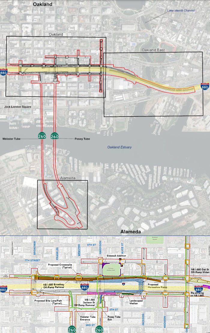 Caltrans, in partnership with the Alameda County Transportation Commission (Alameda
CTC), proposes to improve mobility and accessibility, traffic operations,
and bicycle and pedestrian facilities through the Oakland Alameda Access
Project (proposed project) on Route 260 (R0.78/R1.90) and on I-880
(30.47/31.61) in the cities of Oakland and Alameda in Alameda County,
California. The EIR for the project notes that the Oakland Alameda Access
Project, formerly known as the Broadway/Jackson Interchange Project and
then the Broadway/Jackson Street Interchange Improvements Project, has
been studied for over 20 years. As of September 2020, three Project Study
Reports (PSR), a Project Report (PR), and a Feasibility Study evaluated
numerous alternatives to address the Purpose and Need. A Draft PSR was
prepared in 1997, a subsequent PSR was completed in 2000, and a PR was
completed in 2002 for the Broadway/Jackson Street Interchange Improvements
Project. However, the recommended alternative did not have the support of
the local community, particularly key stakeholders in Chinatown, so it did
not proceed. In 2006, the City of Alameda revisited the project by
completing a Feasibility Study for the I-880/Broadway-Jackson Interchange
Improvements Project. The Feasibility Study recommended several new
alternatives and a PSR-Project Development Support (PDS)-Project
Initiation Document (PID) for the I-880/Broadway-Jackson Interchange
Improvements Project. This study was approved by Caltrans in March 2011.
Caltrans, in partnership with the Alameda County Transportation Commission (Alameda
CTC), proposes to improve mobility and accessibility, traffic operations,
and bicycle and pedestrian facilities through the Oakland Alameda Access
Project (proposed project) on Route 260 (R0.78/R1.90) and on I-880
(30.47/31.61) in the cities of Oakland and Alameda in Alameda County,
California. The EIR for the project notes that the Oakland Alameda Access
Project, formerly known as the Broadway/Jackson Interchange Project and
then the Broadway/Jackson Street Interchange Improvements Project, has
been studied for over 20 years. As of September 2020, three Project Study
Reports (PSR), a Project Report (PR), and a Feasibility Study evaluated
numerous alternatives to address the Purpose and Need. A Draft PSR was
prepared in 1997, a subsequent PSR was completed in 2000, and a PR was
completed in 2002 for the Broadway/Jackson Street Interchange Improvements
Project. However, the recommended alternative did not have the support of
the local community, particularly key stakeholders in Chinatown, so it did
not proceed. In 2006, the City of Alameda revisited the project by
completing a Feasibility Study for the I-880/Broadway-Jackson Interchange
Improvements Project. The Feasibility Study recommended several new
alternatives and a PSR-Project Development Support (PDS)-Project
Initiation Document (PID) for the I-880/Broadway-Jackson Interchange
Improvements Project. This study was approved by Caltrans in March 2011.
(Source: Draft Environmental Impact Report/Environmental Assessment and Draft Individual Section 4(f) Evaluation, Oakland Alameda Access Project, September 2020)
The September 2020 Draft EIR notes the following
alternatives:
(Source: Draft Environmental Impact Report/Environmental Assessment and Draft Individual Section 4(f) Evaluation, Oakland Alameda Access Project, September 2020)
Additional detail on the Build Alternative improvements
include the following:
(Source: Draft Environmental Impact Report/Environmental Assessment and Draft Individual Section 4(f) Evaluation, Oakland Alameda Access Project, September 2020)
In December 2020, it was reported that a plan that has
been decades in the works to reconfigure the ramps of I-880 in
Oakland’s Chinatown — and which thousands of Alameda commuters
use daily — to help ease traffic congestion is moving forward. Known
as the Oakland Alameda Access Project, the plans for around
Interstate 880 include the creation of a right-turn-only lane onto Fifth
Street at the exit of the Posey Tube, which carries traffic from Alameda
into Oakland, to provide almost direct access to the freeway both north
and south. The project also calls for widening the interstate’s
northbound Oak Street off-ramp and removing the northbound Broadway
off-ramp. Madison Street will be restriped to allow for two-way travel
between Fourth and Sixth streets. It currently is one-way for traffic
traveling west. Jackson will be restriped for one-way travel between Fifth
and Sixth. The changes also include increasing the width of a maintenance
walkway in the Webster Tube, which carries traffic from Oakland under the
Oakland Estuary into Alameda, from three to four feet to better support
pedestrians and cyclists. Work on the $120 million project by the Alameda
County Transportation Commission is expected to begin in the middle of
2023 and be finished in three years. Other parts of the plan include new
sidewalks on Fifth and Sixth streets in Oakland, a sidewalk that encircles
the Chinese Garden Park on Seventh Street in Chinatown, and a two-way
bicycle path on Oak and Sixth streets in Oakland. To learn more about the
project, review the draft environmental document and submit comments, go
to www.OaklandAlamedaAccessProject.com.
(Source: East Bay Times, 12/8/2020)
In June 2021, the CTC approved amending the STIP to use
the funding available through the 2021 Mid-Cycle STIP and share
distribution of the federal Coronavirus Response and Relief Supplemental
Appropriations Act of 2021 funds (COVID Relief Funds) to add a new project
to the STIP: Route 880 Oakland/Alameda Access, Broadway-Jackson,
Improvement (PPNO 0044D) and program $50K to the PS&E phase in FY
2022-23.
(Source: June 2021 CTC Agenda, Agenda Item
2.1a.(19))
In May 2022, the CTC approved for future consideration
of funding the following project: 04-Ala-880, PM 30.47/31.61; 04-Ala-260,
PM R0.78/R1.90. Oakland Alameda Access Project. Improve
connectivity and accessibility between Alameda and I-880 by way of Route 260 in Alameda County. (FEIR) (PPNO 0044D) (STIP) The project is located
on I-880 between postmile R30.47 and R31.61 and along Route 260 between
postmile R0.78 and R1.90 in Alameda County. The proposed project would
improve multimodal safety for all users and reduce conflicts between
regional and local traffic by enhancing bicycle and pedestrian
accessibility and connectivity. It would also improve mobility and
accessibility between I-880 and Route 260, the City of Oakland downtown
neighborhoods and the City of Alameda, and reduce freeway-bound regional
traffic and congestion on local roadways and area neighborhoods. This
project is currently programmed in the 2020 State Transportation
Improvement Program (STIP) for a total of $127,728,000, which includes
Right of Way (capital and support). Construction is estimated to begin in
2024-25. The scope, as described for the preferred alternative, is
consistent with the project scope as programmed by the Commission in the
2020 STIP. Under the Build Alternative, access to northbound and
southbound I-880 from the Posey Tube would be improved by adding a
right-turn-only lane from the Posey Tube to 5th Street and a
new horseshoe connector at Jackson Street below the I-880 viaduct that
would connect to the existing northbound I-880/Jackson Street on-ramp. The
Build Alternative would also include a two-way bicycle/pedestrian walkway
through the Posey Tube. The construction of a right-turn-only lane from
the Posey Tube Approach to 5th Street would modify the Tube in
Oakland by demolishing 175 feet of the eastern Approach wall and staircase
for a new turn lane onto 5th Street. The Approach’s
extant straight wall would be replaced by a new curved wall that would
extend onto 5th Street. The construction of the left-turn-only
lane from the Posey Tube exit to 6th Street would modify the
Tube by demolishing 93 feet of the Oakland Approach’s western wall,
including the existing western pylon base. The Approach’s existing
straight walls would be replaced by new walls that would extend onto 5th
Street and 6th Street, respectively. There likely will not be
sufficient room under the I-880 viaduct to relocate the existing western
pylon base at the end of the proposed western wall. Relocation options
will be evaluated following additional data collected during the
project’s design phase. The eastern pylon base will be preserved in
place and stabilized as part of this project. The demolition of the
Approach’s eastern wall and stairs, the demolition of the western
wall including its pylon base, the construction of the new wall with a
different configuration, and the construction of the bicycle/pedestrian
ramp around the Portal building would result in the partial removal of,
physical destruction of, or damage to this historic property under 36 CFR
800.5(a)(2)(i) and (ii). A two-way bicycle/pedestrian accessible ramp
would be installed at the Posey Tube’s Oakland exit. This ramp would
replace the existing staircase attached to the Oakland Approach’s
eastern wall, and would transition to an at-grade path that wraps around
the Oakland Portal building. The path would replace the existing concrete
sidewalk and curb on the west (4th Street) side of the building. The
construction of the bicycle/pedestrian walkway at or near the Portal
building would result in the partial removal of, physical destruction of,
or damage to this historic property under 36 CFR 800.5(a)(2)(i) and (ii).
(Source: May 2022 CTC Agenda, Agenda Item 2.2c.(8))
In January 2023, the CTC amended the Local Partnership
Formulaic Program to add the Oakland Alameda Access Project in Alameda
County (04-Ala-260 R0.78/R1.90, 04-Ala-880 30.47/31.61) and program
$196,000 in fiscal year 2022-23. This project will provide active
transportation facilities, pedestrian and bicyclist safety enhancements,
realignment of offramps and onramps to address circulation issues, as well
as other roadway improvements. The anticipated benefits of this project
include improved multimodal mobility and accessibility between the cities
of Oakland and Alameda and easing local roadway congestion around I-880
and Route 260.
(Source: January 2023 CTC Agenda, Agenda Item 4.10)
In March 2023, the CTC approved the following
allocation for a locally-administered STIP project: $50,000. 04-Ala-880
R30.47/R31.61. PPNO 04-0044D; ProjID 0400000326; EA 0G360. Oakland
Alameda Access Project. Project is located on I-880 and Route 260
between 5th Avenue Overhead and 5th and 6th
Street Viaduct within the Cites of Oakland and Alameda in Alameda County.
The project proposes to improve access along I-880 and in and around the
Webster and Posey Tubes (Route 260 tunnels under the Oakland Estuary
[Tubes]), downtown Oakland, and the City of Alameda. Proposed improvements
also include implementation of follow up landscaping work to restore
removed vegetation required by the highway improvements. CEQA - EIR,
08/20/2021. NEPA - FONSI, 08/20/2021. Future consideration of funding
approved under Resolution E-22-36; May 2022. Contribution from other
sources: $12,000,000. Allocation: PS&E $50,000.
(Source: March 2023 CTC Agenda, Agenda Item 2.5c.(2) #2)
In June 2023, the CTC approved the following allocation
for a locally-administered LPP (Formulaic) project: $196,000. 04-Ala-880
R30.47/R31.61. PPNO 04-0044D; ProjID 0400000326; EA 0G360. Oakland
Alameda Access Project. Project is located on I-880 and Route 260
between 5th Avenue Overhead and 5th and 6th
Street Viaduct within the Cites of Oakland and Alameda in Alameda County.
The project proposes to improve access along I-880 and in and around the
Webster and Posey Tubes (Route 260 tunnels under the Oakland Estuary
[Tubes]), downtown Oakland, and the City of Alameda. Proposed improvements
also include implementation of follow up landscaping work to restore
removed vegetation required by the highway improvements. CEQA - EIR,
08/20/2021. NEPA - FONSI, 08/20/2021. Future consideration of funding
approved under Resolution E-22-36; May 2022. Allocation: R/W $196,000.
(Source: June 2023 CTC Agenda, Agenda Item 2.5s.(2) #1)
In October 2023, the CTC approved the following
amendment request for the Local Partnership Program: The Alameda County
Transportation Commission requests to amend the Oakland Alameda Access
Project in Alameda County and add $7,281,000 of its available 2022
Formulaic Program funding to the Construction phase in fiscal year
2024-25. This project was programmed at the January 2023 Commission
meeting with 2020 Formulaic Program funds to the Right-of-Way phase. This
project will remove and modify existing freeway ramps, modify the
connection from the Posey Tube (Route 260) to I-880, construct Class IV
two-way cycle tracks in Oakland, and implement bicycle and pedestrian
improvements near the Posey Tube and the Webster Tube. The anticipated
benefits of this project are enhanced safety, reduction in greenhouse gas
emissions, and providing multimodal choices for travelers.
(Source: October 2023 CTC Agenda, Agenda Item 4.26)
In December 2024, the CTC approved an allocation of
$67,625,000 for the STIP/SB 1 Local Partnership Program (Competitive and
Formulaic) Oakland Alameda Access Project: 04-Ala-260 R0.78/R1.90,
04-Ala-880 R30.47/R31.61. PPNO 04-0044D; ProjID 0400000326; EA 0G360. Oakland
Alameda Access Project. Project is located on I-880 and Route 260
between 5th Avenue Overhead and 5th and 6th
Street Viaduct within the Cites of Oakland and Alameda in Alameda County.
The project proposes to improve access along I-880 and in and around the
Webster and Posey Tubes (Route 260 tunnels under the Oakland Estuary
[Tubes]), downtown Oakland, and the City of Alameda. Proposed improvements
also include implementation of follow up landscaping work to restore
removed vegetation required by the highway improvements. CEQA - EIR,
08/20/2021; Re-validation 10/07/2024. NEPA - FONSI, 08/20/2021;
Re-validation 10/07/2024. Future consideration of funding approved under
Resolution E-22-36; May 2022. Right of Way Certification: 10/14/2024.
Contribution from other sources: $51,375,000. As part of this allocation
request, the implementing agency is requesting to extend the completion of
CONST an additional 6 months beyond the 36 month deadline. Allocation:
RIP/24-25: CON ENG $18,000,000; CONST $17,344,000; LPP-C/24-25: CONST
$25,000,000; LPP-F/24-25 CONST $7,281,000.
(Source: December 2024 CTC Agenda, Agenda Item 2.5s.(4))
In June 2025, the CTC approved for future consideration
of funding 04-Ala-880, PM 30.47/31.61; 04-Ala-260, PM
R0.78/R1.90; PPNO 04-0044D. Oakland Alameda Access Project. Improve
connectivity and accessibility between Alameda and I-880 by way of Route 260. The Department, in partnership with Alameda County Transportation
Commission, proposes to improve mobility and accessibility. Specifically,
the project will improve motorist, pedestrian, and bicycle safety, reduce
conflicts between regional and local traffic, and enhance bicycle and
pedestrian accessibility and connectivity within the project area by
removing and modifying existing freeway ramps, modifying the connection
from the Posey Tube to I-880, constructing Class IV two-way cycle tracks
in Oakland, implementing various related "complete streets" improvements,
implementing bicycle and pedestrian improvements at the approaches to the
Tubes, and opening the Webster Tube's westside walkway to bicyclists and
pedestrians. The project is currently programmed in the 2024 State
Transportation Improvement Program (STIP). The total programmed amount,
which includes Right of Way (Support and Capital) and Construction
(Support and Capital) is $151,917,000 in STIP, Regional Improvement
Program (RIP), and Senate Bill 1 (SB 1) Local Partnership Program (LPP)
(Formulaic). Construction began in Fiscal Year 2024-25. The scope, as
described for the preferred alternative, is consistent with the project
scope as programmed by the Commission in the 2024 STIP. The
Commission accepted the FEIR and approved the project for future
consideration of funding on May 18, 2022, under Resolution E-22-36. Since
the approval of the FEIR, there have been changes to the project and an
Addendum was prepared pursuant to the California Environmental Quality Act
(CEQA). Specifically, the Addendum addresses minor design modifications,
including overhead and roadside signage, minor changes in permanent
maintenance easements, retaining wall modifications, Americans with
Disabilities Act (ADA)- compliant curb ramps, pavement rehabilitation and
associated improvements, driveway access control modifications, raised
cycle track, crosswalk and sidewalk modifications, modifications to median
and sidewalk landscaping, changes to proposed utility undergrounding and
relocations, changes in tree removal and on-street parking, and conversion
of a Harrison Street segment from bidirectional traffic to one-way
traffic. The modifications expand the project footprint within I-880
right-of-way (ROW) and on some local streets. There is no change to the
construction duration. The design modifications expand the project
footprint mostly within the I-880 ROW to accommodate signage and on some
local streets where proposed ADA-compliant curb ramps, pavement
rehabilitation, sidewalks, and other improvements would occur. Resources
in the project area that may be impacted by the project include cultural
resources. Potential impacts associated with the project can all be
mitigated to below significance with the exception of cultural resources,
for which a Statement of Overriding Considerations was prepared. In
accordance with CEQA Guidelines Section 15162, no Subsequent FEIR is
required for the project because new information and changes in
circumstances, project description, impacts, and mitigation are not
substantial and do not involve new significant impacts or a substantial
increase in the severity of previously identified impacts. As a result,
the Department completed an Addendum to the FEIR pursuant to CEQA.
(Source: June 2025 CTC Agenda, Agenda Item 2.2c.(4) #1)
In June 2025, the CTC approved the following Allocation
Amendment for a Multi-Funded STIP and Senate Bill 1 LPP (Formulaic and
Competitive) Project to amend the postmiles for the project: 04-Ala-260
R0.78/R1.90, 04-Ala-880 R30.47/R31.61 29.36/R31.6.
PPNO 04-0044D; ProjID 0400000326; EA 0G360. Oakland Alameda Access
Project. Project is located on I-880 and Route 260 between 5th
Avenue Overhead and 5th and 6th Street Viaduct
within the Cites of Oakland and Alameda in Alameda County. The project
proposes to improve access along I-880 and in and around the Webster and
Posey Tubes (Route 260 tunnels under the Oakland Estuary [Tubes]),
downtown Oakland, and the City of Alameda. Proposed improvements
also include implementation of follow up landscaping work to restore
removed vegetation required by the highway improvements.
(Source: June 2025 CTC Agenda, Agenda Item 2.5s.(6))
In March 2026, the CTC adopted the 2026 STIP, which
included the following as continued programming from 2024: PPNO 04-0044D,
“Rt 880, Oakland/Alameda Access, Broadway-Jackson (LPP-C)”.
Prior years programming ($ × 1000): $35,344 ($17,344 CONST; $18,000
CON SUP). No FY26-27+ funds programmed.
(Source: March 2026 CTC Agenda, Agenda Item 4.4; 2026 STIP Staff Recommendations Adopted 2/27/2026)
In March 2026, it was reported that a $175 million plan
to overhaul traffic between Alameda and Oakland has the goal of
redirecting thousands of cars away from Chinatown streets long plagued by
pedestrian deaths, congestion and poor air quality. The first stage of the
project will remove a freeway exit and redirect thousands of cars away
from Chinatown streets while expanding bike and pedestrian routes. The
I-880 Broadway exit will be demolished to “reduce regional
traffic” while pedestrian and bike routes will be widened between
Alameda’s Mariner Square loop, the Webster Tub and Chinatown. While
these changes could benefit Jack London Square and the businesses it
hosts, construction will temporarily close the Posey and Webster tubes
during the three-year project. The Posey Tube exit with I-880 will be
rerouted away from Chinatown via a new “horseshoe” that
threads underneath support columns for I-880 and moves drivers to a new
on-ramp. The Broadway off-ramp will be demolished and the Oak Street
off-ramp will be widened, according to planning documents. Caltrans
estimates the new route will reduce traffic by 13,529 cars each day from
the Posey Tube through Harrison Street, representing a nearly 50% drop in
traffic volume. The second stage pivots to creating new traffic flows on
numerous Oakland streets, including restriping Madison Street for two-way
travel and restriping Jackson Street for one-way travel underneath I-880.
The Webster Tube detour will reroute motorists southbound along I-880 to
cross into Alameda along the Park Street Bridge. Caltrans is attempting to
mitigate the effect of these closures on residents and businesses by
operating Sunday through Thursday between 10 p.m. and 6 a.m. during a
six-month period of the first phase of the project. Designers hope that
upon completion, the project will increase active transportation like
walking and biking between the neighborhoods.
(Source: Mercury News, 3/14/2026)
 Named Structures
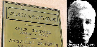 Tunnel 33-0106R, the tube between Alameda and Oakland that goes beneath the Oakland Estuary, is named the "George A.
Posey Tube". It is named for George A. Posey, the engineer who
devised its construction. This construction required sinking precast
concrete segments into a trench running along the floor of the Oakland
Estuary, and includes a ventilation system (designed by Posey) that placed
high-powered fans in the portals on either end of the tube. The tube runs
beneath the floor of the estuary. Construction started in 1925 and was
completed in 1928.
Tunnel 33-0106R, the tube between Alameda and Oakland that goes beneath the Oakland Estuary, is named the "George A.
Posey Tube". It is named for George A. Posey, the engineer who
devised its construction. This construction required sinking precast
concrete segments into a trench running along the floor of the Oakland
Estuary, and includes a ventilation system (designed by Posey) that placed
high-powered fans in the portals on either end of the tube. The tube runs
beneath the floor of the estuary. Construction started in 1925 and was
completed in 1928.
(Image source: Bridgehunter; Oakland LocalWiki)
The other tunnel (33-0106L) is unofficially called the "Webster Street Tube". It was built in 1963.
 Classified Landcaped Freeway
The following segments are designated as Classified Landscaped Freeway:
| County | Route | Starting PM | Ending PM |
| Alameda | 260 | R0.84 | R1.20 |
 Other WWW Links
 Statistics
Overall statistics for Route 260:
 Pre-1964 Legislative Route
In 1959, Chapter 1062 defined LRN 260 as “[LRN 238] to [LRN 4] north of the Calaveras River”. This is present-day unconstructed Route 235 between present-day I-5 and Route 99.
© 1996-2024 Daniel P. Faigin.
Maintained by: Daniel P. Faigin
<webmaster@cahighways.org>.
 Route 259
 Route 261