
 California Highways:
Click here for a key to the symbols used. An explanation of acronyms may be found at the bottom of the page.
 Routing
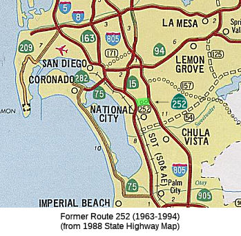 No current routing.
 Post 1964 Signage History
 ▸In 1963, Route 252 was defined as “Route 5 to Route 805 near the north city limits of National City.”
▸This routing was deleted in 1994 by AB 3132, Chapter 1220.
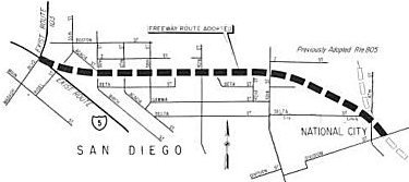 In 1965, the CTC adopted a freeway alignment for Route 252 in its entirety in San Diego and National City. This 1.8-mile
connecting link between I-5 and I-805 freeways proceeds easterly from I-5
at Wabash Boulevard (Route 103), approximately one block north of Beta
Street, to 43rd Street
In 1965, the CTC adopted a freeway alignment for Route 252 in its entirety in San Diego and National City. This 1.8-mile
connecting link between I-5 and I-805 freeways proceeds easterly from I-5
at Wabash Boulevard (Route 103), approximately one block north of Beta
Street, to 43rd Street
in San Diego. It then turns southeasterly to the adopted route for the
future I-805 at Division Street in National City.
This was supposed to act as the north end of an I-5 bypass around National City and Chula Vista, utilizing I-805. According to Andy Field, the huge flyover and approach ramps at the I-805 43rd Street exit are the beginnings of this planned freeway, which was killed locally in 1980.
The earliest public discussion of the freeway was at a meeting of
the San Diego City Council on April 30, 1968. This is when three
resolutions related to the freeway agreements with the Division of
California State of California Highways covering the proposed development
route were discussed. The state wanted to build Route 252 as an East/West
link between I-5 and I-805. The route for the 252 was only 1.3 miles long
, and it went right down the middle of South Crest. At this meeting , the
city council was being asked to sign off on that route. At the meeting,
the council voted unanimously to build the freeway. Councilman Leon
Williams , San Diego's first black city council member, was appointed to
the fourth Council District, which included South Crest, in 1969. He was
one of the most vocal critics of Route 252. When Councilman Williams got
on the council, he hired community organizers , recruited residents to
serve as captains of their block to make sure everyone knew what was going
on at City Hall. The concern was that this was one of the places where
people of color could own their own homes and businesses. When the state
went looking for where to build its freeways, communities like South
Crest, where land values were relatively cheap , were easy targets. With
the city's blessing , the state seized and demolished 280 homes for the
Route 252 freeway. Hundreds of people had to leave with little help to
relocate, and 66 acres of South Crest were cleared and left vacant. The
ones who were the most affected emotionally and financially were the
homeowners who had been there for a number of years. Once the state
started clearing the right of way for Route 252, community organizing
became key. In 1973, activists in Southeast San Diego founded the Black
Federation, and stopping Route 252 was one of their main campaigns.
In 1975 , the city council revisited its support for Route 252, but the
freeway opponents were no match for Jacob Dekama of Caltrans District 11
and the interest groups. The council voted 6 to 3 to stick with the plan
of building the freeway. So in 1975, Caltrans got a renewed mandate from
San Diego politicians to go ahead and build Route 252. The agency wasted
no time and built the interchange with I-805 that year in anticipation of
the full freeway getting built later. However, the change from the Reagan
to the Brown administration led to a push for a more balanced
transportation system. At the same time, the movement to stop Route 252 in
Southwest was making some progress. It got the city council to revoke its
support for the freeway in 1978 , but they still had to convince the state
not to build it. Things stayed in limbo until 1986, when the State
Transportation Commission took Route 252. That meeting in 1986 was the
final nail in the coffin for Route 252. Caltrans was ordered to abandon
the freeway and sell the land all 66 acres back to the city of San Diego.
It took a lot longer to rebuild South Crest than it did to tear it down.
But by the year 2000, the Rpite 252 corridor had been redeveloped with
hundreds of new homes, new water and sewer pipelines, parks, restaurants
and the community's first grocery store in more than 30 years.
(Source: KPBS "Freeway Exit" Podcast, Ep. 3, "The Freeway Revolts", 5/16/2023)
In the late 1960s and early 1970s, the California Division of Highways
acquired 66 acres of property in Southcrest to build Route 252. It would
have been an east-west connector between I-5 and I-805. Decades of
community opposition ultimately forced the state to abandon the freeway
project and sell the land back to the city of San Diego, which gradually
redeveloped it into housing, parks, a shopping center and an elementary
school.
(Source: KPBS, 6/13/2023)
A redevelopment project later resulted in a grocery store (Northgate Market Plaza, as of 2020) at the terminus of the off-ramp. Behind this shopping area lies abandoned right-of-way that not been developed. Overgrown with weeds, this swath of land clearly shows the path Route 252 would have taken across the Southcrest community to meet I-5. These ramps were built around 1974-75, long before the rest of the California 252 project would have been started. These ramps still show up as part of Route 252 in the CalTrans Photologs in 2001. Several widened bridges and ramps at the I-15/Route 15 junction clearly show that future expansion for the Route 252 connection was envisioned.
At the center of Southcrest Trails Neighborhood Park sits a public art
project inspired by the community's decades-long battle to stop the
freeway. The circular plaza was designed by artists Ingram Ober and
Marisol Rendón. The husband and wife duo were selected by the city's
Commission for Arts and Culture to develop a public art installation for
the park, which opened in 2018. Ober and Rendón learned the backstory
of the battle through meetings with local residents. Those interviews
inspired the artists to photograph residents pronouncing the various names
their community has been known by — Southcrest, Shelltown, Chollas
Creek and home. Those portraits were merged into composite images and
turned to molds, which then produced roughly 380 concrete bas-relief
sculptures. The end result is a chorus of community members reclaiming
both their land and their neighborhood's identity.
(Source: KPBS, 6/13/2023)
 Pre 1964 Signage History
This was part of LRN 283, defined in 1959. It appears to have been near 8th Street.
 Naming
 Other WWW Links
 Freeway
Originally to have been freeway; later deleted from SHC 253.1.
 Pre-1964 Legislative Route
In 1947, Chapter 1449 extended the definition of LRN 252 to include “the highway from San Leandro to Oakland via Alameda and the Posey Tube”, noting that this segment “is part of [LRN 252]”. However, the problem was that LRN 252 did not exist at the time. In 1949, Chapter 1422 repealed the erroneous section, and created the route as an extension of LRN 226.
The real LRN 252 was created in 1959 by Chapter 1062, with the definition “[LRN 69] near Nicasio to [LRN 1] near Novato”. This runs from present-day Route 251 to US 101, and is an unconstructed portion of Route 37.
© 1996-2020 Daniel P. Faigin.
Maintained by: Daniel P. Faigin
<webmaster@cahighways.org>.
 Route 251
 Route 253