
 California Highways:
Click here for a key to the symbols used. An explanation of acronyms may be found at the bottom of the page.
 Routing
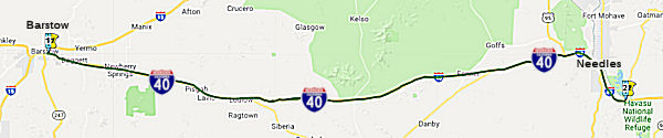 From Route 15 at Barstow to the Arizona state line near
Topock, Arizona via Needles.
From Route 15 at Barstow to the Arizona state line near
Topock, Arizona via Needles.
 Post 1964 Signage History
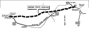 ▸In 1963, this routing was
defined as "Route 15 at Barstow to the Arizona state line near Topock,
Arizona via Needles, together with an extension from a point on such Route 40 near Needles easterly by the most direct and practicable route to the
Arizona-California line at the Colorado River, including a bridge over and
across said river, to be constructed, owned, operated, and maintained
jointly with the State of Arizona."
▸In 1963, this routing was
defined as "Route 15 at Barstow to the Arizona state line near Topock,
Arizona via Needles, together with an extension from a point on such Route 40 near Needles easterly by the most direct and practicable route to the
Arizona-California line at the Colorado River, including a bridge over and
across said river, to be constructed, owned, operated, and maintained
jointly with the State of Arizona."
In Barstow, the segment of Business Route 40 along Main Street to a point just W of I-15 is officially part of Route 40, with S prefix postmiles.
In 1965, the new I-40 bridge over the Colorado River was under
construction in California and Arizona, expected to open in 1966. Funding
was also allocated for the Daggett-Ludlow segment of I-40 and a segment
from Java east to Needles. By 1969, maps showed I-40 completed from
Barstow east to Ludlow and on both sides of Needles. By 1975, I-40 was
completed from Barstow east to the Arizona State Line.
(Source: Gribblenation Blog (Tom Fearer), “Interstate 40 and the H-Bomb”, March 2021)
US 66 was truncated to US 95 in Needles in 1972 following the completion
of I-40 in the Bristol Mountains. In 1979 Arizona Department of
Transportation sought and received permission to decommission US 66 from
US 95 at Needles through most of Arizona to US 666 in Sanders.
The truncation of US 66 from US 95 in Needles to US 666 in Sanders
was approved on June 27th, 1979.
(Source: Gribblenation Blog (Tom Fearer), “Interstate 40 and the H-Bomb”, March 2021)
Note: See the Gribblenation Blog “Interstate 40 and the H-Bomb” for a more detailed history of the construction of I-40, including links to maps and photos for the route. The above are excepts and condensations from that blog.
▸In 1981, Chapter 292 shortened the definition to eliminate the mention of the extension and the bridge.
 Pre 1964 Signage History
 The specific routing corresponding to this did not exist before 1964 (i.e., the interstate routing). In fact, the Interstate routing was adopted in January and February 1963. An approximate routing
is that of the old US 66 (now the National Trails Highway) between Barstow
and Needles. That routing was signed as US 66, and was LRN 58, defined in
1919.
The specific routing corresponding to this did not exist before 1964 (i.e., the interstate routing). In fact, the Interstate routing was adopted in January and February 1963. An approximate routing
is that of the old US 66 (now the National Trails Highway) between Barstow
and Needles. That routing was signed as US 66, and was LRN 58, defined in
1919.
Main Street - Barstow
[Note: Main Street in Barstow is part of Route 40, but is not part of I-40. Rather, it is "S" postmile routing, indicating a spur routing or a rerouting of R mileage. It is unclear why Caltrans did not make this a formal spur suffix (i.e., Route 40S in the Post Mile system), other than perhaps it is a city street and not a freeway.]
Main Street in Barstow is an unsigned segment of Route 40 with S postmiles (unclear if there are any PM paddles or markers on
streetlights) that is former US 66. It has been retained in the state
system to permit movement from WB I-40 to NB I-15. Its designation is
connected to the 1961 opening of the Barstow Bypass. The
Barstow Bypass was primarily a component of I-15 that included the exit
ramp to I-40 and the first stub of the freeway eastward towards
Needles. The mainlines of US 66 and US 91 were relocated onto the
new freeway bypass whereas the previous surface routings were retained as
a business routes. Main Street (former US 66) between I-40 and I-15
was retained as a spur of LRN 58, due to the I-15/I-40 interchange not
permitting traffic to transition from westbound I-40 to NB I-15 and SB
I-15 to EB I-40. US 66 was truncated from Santa Monica to US 95 in
Needles by AASHO on November 14, 1963, but signage of US 66 would not be
truncated from Pasadena to US 95 until I-40 was completed through the
Bristol Mountains in 1972. At that time US Business Route 66 on Main Street in
Barstow was swapped without application to Business Route 15. Further, when LRNs were
dropped as part of the 1964 renumbering, spur facility of LRN 58 on Main
Street between I-40 and I-15 was re-designated as Route 40, but with "S"
postmiles (which are distinct between the original (no prefix) or
realignment ("R") postmiles on the mainline). The "S" postmile segment of
Route 40 remains minimally signed as Business Route 15.
(Source: Gribblenation Blog (Tom Fearer), "Interstate 40 Spur in Barstow", 2/2024)
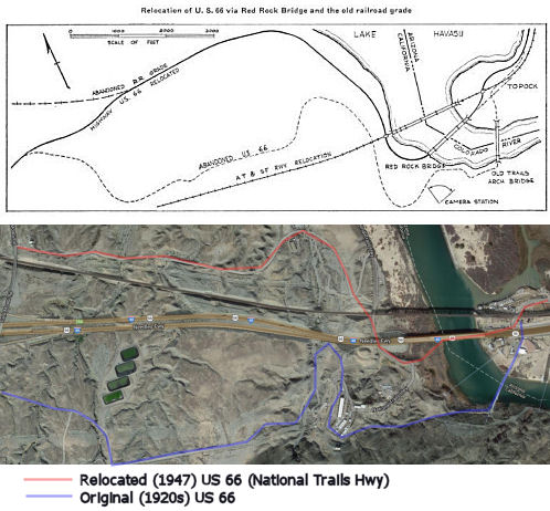 In 1947, the Department of Highways moved Route 66 to a
new alignment and a new bridge across the Colorado River. The movement to
the Red Rock Bridge permitted elimination of one of the narrowest and
crookedest portions of US 66. The cost to move to the Red Rock Bridge was
only $147K, of which $71.5K was spent replacing the rail deck of the
bridge, $70.5K was spent widening the old railroad approach, and $5K was
spent to connect it to the existing US 66. The opportunity to replace the
bridge arose when ATSF obtained approval to build a new RR bridge 500'
upstream in 1942. The Red Rock bridge was set to be scrapped for its
steel, but the Army was interested in the bridge and analysis showed that
the need for steel would be over before the scrapping could occur.
Negotiations were reopened, and the bridge was finally donated to the
states in 1944. The history of the bridge going back to Civil War days may
be found in the July/August 1947 issue of CHPW. Note that an act of Congress in December 1944 was required to confirm that ATSF could transfer the bridge. The old
bridge was completed in 1916, and had a load limit of 11 tons. The
construction of Parker Dam also served to submerge the steel supports of
the old bridge. The new bridge was designed to support 94 ton trains. Note
that it appears that the both the old bridge and the Red Rock bridge (or
at least their locations) are still in use as of 2013 -- the Red Rock
Bridge still appears to be supporting the traffic of I-40 (although it may
have been rebuilt -- it still is in the correct location with respect to
the RR bridge), and the original 1916 bridge appears to now be supporting
a pipeline.
In 1947, the Department of Highways moved Route 66 to a
new alignment and a new bridge across the Colorado River. The movement to
the Red Rock Bridge permitted elimination of one of the narrowest and
crookedest portions of US 66. The cost to move to the Red Rock Bridge was
only $147K, of which $71.5K was spent replacing the rail deck of the
bridge, $70.5K was spent widening the old railroad approach, and $5K was
spent to connect it to the existing US 66. The opportunity to replace the
bridge arose when ATSF obtained approval to build a new RR bridge 500'
upstream in 1942. The Red Rock bridge was set to be scrapped for its
steel, but the Army was interested in the bridge and analysis showed that
the need for steel would be over before the scrapping could occur.
Negotiations were reopened, and the bridge was finally donated to the
states in 1944. The history of the bridge going back to Civil War days may
be found in the July/August 1947 issue of CHPW. Note that an act of Congress in December 1944 was required to confirm that ATSF could transfer the bridge. The old
bridge was completed in 1916, and had a load limit of 11 tons. The
construction of Parker Dam also served to submerge the steel supports of
the old bridge. The new bridge was designed to support 94 ton trains. Note
that it appears that the both the old bridge and the Red Rock bridge (or
at least their locations) are still in use as of 2013 -- the Red Rock
Bridge still appears to be supporting the traffic of I-40 (although it may
have been rebuilt -- it still is in the correct location with respect to
the RR bridge), and the original 1916 bridge appears to now be supporting
a pipeline.
The first freeway segment to open was in 1957, consisting of the first
two lanes of what would become I-40 from Needles S towards the Arizona
State Line. It was opened to traffic on October 15th, 1957. In 1961, 3.1
miles of planned I-40 from the Arizona State Line westward had been
adopted. Also in 1961, the Barstow Bypass opened. This was primarily a
component of I-15, but included the exit ramp to I-40 and the first stub
of the freeway eastward towards Needles.
(Source: Gribblenation Blog (Tom Fearer), “Interstate 40 and the H-Bomb”, March 2021)
In 1962, the ATSF railroad wanted a new route across the mountains from
Barstow to Needles to shave 15 miles off the route through the Bristol
Mountains. So in December 1962, the Santa Fe Railway contacted the US Atomic Energy Commission (AEC), to ask if the job could instead be done
with hydrogen bombs. This was in support of the AEC's plan for peaceful
use of nuclear explosions. One such use was nuclear excavation. At the
same time, the California Department of Public Works (DPW) was planning a
new road through the area to shorten US 66, and they joined the project as
well. The AEC, DPW, and the railway together published a feasibility study
in November of 1963 proposing to use 23 nuclear bombs, totaling 1,830
kilotons, to blast the new pass through the Bristols. They called the plan
Project CARRYALL. Twenty-two devices of 20 to 200 kilotons yield would be
set off 340 to 780 feet underground. The explosions would
remove 68,000,000 cubic yards of earth, creating a roughly parabolic cut
11,000 feet long, 360 feet deep, and from 600 to 1,300 feet wide. A final
100-kiloton device would dig a drainage crater to hold rainwater runoff
from the new pass. The railroad would open for traffic in April of 1969,
the highway following in July. The total cost was estimated at
$14 million ($104 million today) - a savings of $8 million ($59 million)
compared to conventional methods. Byt the tests that would lead to
the construction never happened, thanks to the Limited Test Ban Treaty.
The California highway division dropped out of CARRYALL in September of
1966, unwilling to wait any longer. For more details, see the page on Project CARRYALL.
(Source: Atomic Skies: Project CARRYALL, 2/14/2014)
In 1962, 32.8 miles of planned I-40 between Newberry Springs and Ludlow
was adopted. Additionally, there were budget allocations for a new
US 66/I-40/US 95 interchange, as well as construction of I-40 east of
Barstow eastward past Daggett. 1963 saw adoption of 83 miles of planned
I-40 from Ludlow east through the Bristol Mountains to US 95 near
Java.
(Source: Gribblenation Blog (Tom Fearer), “Interstate 40 and the H-Bomb”, March 2021)
 In 1926, US 40 was designated as the "Victory Highway", entering
California through the Truckee River canyon, thence through Auburn,
Sacramento, Davis, Fairfield, Benecia, Martinez, Richmond, and thence to
Oakland (note that, at some point, the Victory Highway designation was
moved to Route 160). In 1928, the routing was formalized as the route
beginning at San Francisco, crossing the bay to Oakland, Martinez, Davis,
Sacramento, Auburn, Truckee, via the Nevada-California state line west of
Verdi. This is a routing roughly parallel to the existing I-80. It had the
following LRNs:
In 1926, US 40 was designated as the "Victory Highway", entering
California through the Truckee River canyon, thence through Auburn,
Sacramento, Davis, Fairfield, Benecia, Martinez, Richmond, and thence to
Oakland (note that, at some point, the Victory Highway designation was
moved to Route 160). In 1928, the routing was formalized as the route
beginning at San Francisco, crossing the bay to Oakland, Martinez, Davis,
Sacramento, Auburn, Truckee, via the Nevada-California state line west of
Verdi. This is a routing roughly parallel to the existing I-80. It had the
following LRNs:
Originally, the routing used the Martinez-Benicia Ferry. Access to
the Martinez-Benicia Ferry was by way of LRN 14 and LRN 7. LRN 14 was
routed into Martinez via what is now Carquinez Scenic Drive east of
Crockett. LRN 7 entered Benicia via 2nd Street. LRN 14 and LRN 7 can
be seen meeting at the Carquinez Straights at the Martinez-Benicia
Ferry on the 1918 Division of Highways Map. The initial routing of US 40 was aligned over LRN 7 into Benicia, over the Martinez-Benicia
Ferry and LRN 14 towards Oakland. The primary driver of US 40 being
routed away from Benicia and Martinez was the completion of the
original Carquinez Bridge in 1927. The Carquinez Bridge originally
carried the second alignment of the Lincoln Highway when it opened as
a private toll bridge. In 1931, a spur route of LRN 7 was adopted from
LRN 14 in Crockett through the American Canyon Route. This spur route
of LRN 7 appears to have been completed some time in 1932. US 40 was
reported rerouted through Vallejo via the Carquinez Bridge and the
American Canyon Route on the 8th Biannual Report by the Division of
Highways in November 1932.
(Includes material from Gribblenation Blog: Interstate 680 over the Benicia-Martinez Bridge and the legacy of California State Route 21 and The original alignment of US Route 40 over the Martinez-Benicia
Ferry and Carquinez Scenic Drive)
Near Dixon and Davis, US 40 ran N on Pedick Road (now County Sign Route E7) to
Russell Road, and then E along Russell into Davis. W of Pedick,
Russell was Route 28 (later Route 128). This was the alignment the
diagonal expressway alignment that became today's I-80 was constructed
in the 1940s. Based on the map, the route then went down B Street and
1st.
(Source: HeyNow415 on AARoads, “Re: CA 128”, 3/17/2021)
Scott Parker on AARoads noted the following regarding the LRNs for US 40:
The sequence of different LRN's hosting US 40 seemed to be an
ever-changing series until the freeway era. LRN 14 was the first "leg"
north from Oakland to Martinez. When US 40 was rerouted over the Carquinez
Bridge, LRN 14 remained as an unsigned route from Crockett to Martinez;
and on the other side of the strait, the original "host" for US 40, Sonoma
Blvd., was a LRN 74 "spur" when US 40 extended up to Napa Junction and
turned east with Route 12 to Cordelia and Fairfield. Then LRN 7, which
originally ran from the Benicia ferry terminal up what is now I-680 to
Cordelia was bypassed by the present I-80 alignment, originally a simple
multilane arterial; Benicia-Cordelia was added to LRN 74, making it a
"U"-shaped route. The Carquinez Bridge was privately owned, so LRN 7
originally began at the toll booth at the bridge's north end. When the
Eastshore Freeway was completed from the Distribution Structure (today's
I-80/I-580/I-880 interchange) north to the Carquinez Strait, the bridge
was twinned with today's EB truss span. At the same time, the Richmond-San
Rafael Bridge was being opened as Route 17/LRN 69; both those
designations, along with US 40 and later the nascent I-80, comprised the
Eastshore Freeway from the Structure north to the present I-80/I-580
divergence at Albany; from 1957 through 1963 LRN 7 was extended over the
Carquinez Bridge (by then Division of Highways property) down to Albany.
At that time LRN 14 was truncated to Richmond over the alignment of
present Route 123 (it had never been assigned to any portion of the
Eastshore Freeway), leaving former US 40 to Contra Costa County. US 40 was
LRN 7 north to Davis, where that LRN turned north on US 99W through
Woodland and Willows to terminate at LRN 3 at the original US 99E/99W
junction at Red Bluff. LRN 6 then carried US 40 east into Sacramento.
(Source: Scott Parker on AARoads, "Re: California", 7/10/2019)
According to "California Highways" by Ben Blow (1920), the Auburn-Emigrant Gap State Road and the Emigrant Gap-Donner Lake State Road were both taken into the State Highway System under the first highway Bond Act of 1909. The section from Truckee to Verdi, the road was added under the third Bond Act of 1919. There is some additional information in the following articles:
The designation was changed on July 1, 1964, when the current I-80
took over the old US-40 route (and Route 113 and Route 70 took over the US 40A route between Yuba City and US 395, and the new route (I-40) was
defined.
In Fairfield, the stretch of former US 40 back to 1915, when only a few thousand people lived in Fairfield and Suisun City. According to an article in the Fairfield Daily Republic, one local contractor working on the original road drove his mule so hard that he ran afoul of the local humane society. The original highway route used old Cordelia Road and went through Suisun City to the courthouse. It later bypassed Suisun City and went down West Texas Street and through downtown Fairfield. The highway department straightened out turns in Cherry Glen in 1936, and built the Vacaville bypass in 1937. About 14,600 cars a day passed through Fairfield on US 40 in 1948. In the mid-1960s, workers enlarged the four-lane US 40 to the eight-lane I-80.
For those trying to follow old US 40, John David Galt noted (in a misc.transport.road posting) that near Suisun the old route jogged north on Suisun Valley Rd. to Rockville Rd., back to the present freeway route in Suisun, where Rockville Rd. becomes Air Base Pkwy. Between there and West Sacramento, there's very little of the old route left other than the freeway. There are bits of frontage road near the Nut Tree and the Hick'ry Pit that may have been part of US 40, but they don't go through. In West Sacramento, the old route leaves the freeway as West Capitol Ave., which is signed only as the "Downtown Sacramento" exit. From there, US 40 followed the Capitol Mall across to 16th St., then picked up the present Route 160 freeway route, ending up on what is now Auburn Blvd. Auburn is now signed as "Historic US 40" for most of its length, all the way into Roseville. At one point, Route 160 and US 40 were cosigned.
 In 1927, the California State Automobile Assn proposed a super-highway
between the San Francisco Bay region and Sacramento. According to an
article published in the Sacramento Bee in November 1927, they
suggested to the state highway commission that relocation of certain
sections of the existing state highway will eliminate thirteen miles of
driving and provide a shorter safer and more direct route between cities
of the metropolitan area and the state capital The proposal was conveyed
to B B Meek director of the state department of public works in a
communication from H J Hrunnier chairman of the Automobile Association
Highways committee Brunnier suggested that the highway commission consider
official adoption of the new and shorter route as one on which future
construction and reconstruction efforts may be directed. The plan has
already been endorsed by the chambers of commerce of San Francisco,
Oakland, and Sacramento. The Association takes the stand that conditions
can be bettered through or around the town of Pinole by the adoption of
the American Canyon route from Vallejo Past Cordelia to Fairfield and
along the section between Fairfield and Davis Brunnier in his letter
pointed out that certain sections of the present route will soon have to
he reconstructed notably through Jamison Canyon between Cordella and the
Napa "Y" and that a more satisfactory route should be adopted before the
present route becomes more definitely fixed. The present route does not
take the fullest advantage of topography. It results in unnecessary
driving of about thirteen miles and an unnecessary number of grade
crossings and its alignment is not conducive to public safety the
association points out. During peaks or traffic, there is bad congestion
at points which with increasing traffic will soon gauge the amount of
travel that can use the present route "This Is the opportune time" said
Brunnier in his letter "to plan for a direct broad and safe highway
between the Northern California center of population and the heart of a
big agricultural region" Besides providing for local travel it is pointed
out the super-highway would be a link in both the Victory Highway route
and the Pacific Highway.
In 1927, the California State Automobile Assn proposed a super-highway
between the San Francisco Bay region and Sacramento. According to an
article published in the Sacramento Bee in November 1927, they
suggested to the state highway commission that relocation of certain
sections of the existing state highway will eliminate thirteen miles of
driving and provide a shorter safer and more direct route between cities
of the metropolitan area and the state capital The proposal was conveyed
to B B Meek director of the state department of public works in a
communication from H J Hrunnier chairman of the Automobile Association
Highways committee Brunnier suggested that the highway commission consider
official adoption of the new and shorter route as one on which future
construction and reconstruction efforts may be directed. The plan has
already been endorsed by the chambers of commerce of San Francisco,
Oakland, and Sacramento. The Association takes the stand that conditions
can be bettered through or around the town of Pinole by the adoption of
the American Canyon route from Vallejo Past Cordelia to Fairfield and
along the section between Fairfield and Davis Brunnier in his letter
pointed out that certain sections of the present route will soon have to
he reconstructed notably through Jamison Canyon between Cordella and the
Napa "Y" and that a more satisfactory route should be adopted before the
present route becomes more definitely fixed. The present route does not
take the fullest advantage of topography. It results in unnecessary
driving of about thirteen miles and an unnecessary number of grade
crossings and its alignment is not conducive to public safety the
association points out. During peaks or traffic, there is bad congestion
at points which with increasing traffic will soon gauge the amount of
travel that can use the present route "This Is the opportune time" said
Brunnier in his letter "to plan for a direct broad and safe highway
between the Northern California center of population and the heart of a
big agricultural region" Besides providing for local travel it is pointed
out the super-highway would be a link in both the Victory Highway route
and the Pacific Highway.
(Source: Joel Windmiller on California's Historic Highways FB/SacBee Nov 1927, 6/2/2020)
In particular, the initial draft of the US Route System was approved by
the Secretary of Agriculture during November of 1925. The US Route System within California was approved by California Highway Commission
with no changes recommended by January 1926. The alignment of US 40
east of Sacramento was planned to follow the existing Northern Branch of
the Lincoln Highway and Victory Highway over LRN 3, LRN 17, LRN 37 and LRN 38 to the Nevada State Line at Verdi.
(Source: Gribblenation Blog (Tom Fearer), “Former US Route 40 in Auburn”, March 2022)
In Sacramento, some of the original street portion has been signed as Historic US 40. The first sign went up in 2001 on West Capitol Avenue in West Sacramento.
In Citrus Heights, the routing ran along Auburn Boulevard. Auburn Road (as it was called then) cut through Sacramento County‟s Central Township (what is present day Citrus Heights) to connect the City of Auburn to Sacramento. In the 1860s, Sylvan School and Sylvan Corners (both of which exist today) became the educational, civic, social and religious center of this early settlement. Until the 1950s, Auburn Boulevard consisted of auto-oriented retail that catered to travelers‟ needs of that bygone era. But with the opening of I-80 in the late 1950s, Auburn Boulevard changed to a commercial corridor serving the local community‟s needs.
In August 2023, it was reported that the City of
Sacramento Department of Public Works is proposing to replace the Auburn
Boulevard Bridge at Arcade Creek due to its structurally deficient and
functionally obsolete status, as determined by the Federal Highway
Administration criteria. The project site is located in the north eastern
corner of the City of Sacramento, near the border with Sacramento County,
where Auburn Boulevard crosses Arcade Creek, east of Winding Way and west
of Park Road and the I-80 ramps. The Auburn Boulevard Bridge over Arcade
Creek is a reinforced concrete T-beam structure that was originally
constructed in 1927, and then widened in 1965. The bridge has two spans
with a total length of 70 feet. It carries two lanes of traffic in both
the eastbound and westbound direction, with a left turn pocket for
westbound to southbound users. The new bridge will be 100 feet wide (see
cross section below) and be raised slightly to remain operational during a
20-year storm event. The new bridge will carry two lanes of traffic in
each direction, with a dual left lane for westbound to southbound users.at
the Auburn Blvd./Winding Way intersection. Preliminary engineering studies
and the environmental review are anticipated to be completed in December
2020. Final Design and Right-of-Way acquisition work will start in 2021
and be completed in 2022 and Construction is anticipated to begin in
Spring 2024.
(Source: City of Sacramento Project Page)
Newcastle: Newcastle was unincorporated community, and was therefore part
of State Maintenance on LRN 17. LRN 17 westbound originally entered
Newcastle via the 1910 Newcastle Subway. The Newcastle Subway was
possibly the first highway Rail Subway built on a State Highway in
California. The 1910 Newcastle Subway is a single lane with only a
12-foot-high clearance. The Newcastle Subway project was instigated
when the Southern Pacific Railroad had decided to double its line in
Newcastle. The subway was improved around 1930, when a 0.9 mile grade
separation for US 40/LRN 17 in Newcastle was budgeted for the 1929-31
Fiscal Years, and a contract was let to construct a 531-foot-long tunnel
on US 40/LRN 17 in Newcastle. It was completed on 12/31/1931. In 1934,
there was further realignment in the Loomis-Newcastle corridor. The
new alignment of US 40/LRN 17 eliminated 42 curves and bypassed Penryn; it
opened 5/29/1934. This, in turn, was replaced with a freeway alignment in
the mid 1950s. Construction of a new freeway grade along US 40/LRN 37 from
Applegate 2.7 miles east to Heather Glen started in 1955. By 1956, the
Newcastle-Auburn expressway segment of US 40/LRN 17 was under construction
and the Roseville-Newcastle freeway was in the design stages. Projects
were completed by late 1959.
(Source: Gribblenation Blog (Tom Fearer), "Former US Route 40, the North Lincoln Highway and Victory Highway in Newcasstle", 1/17/2022)
Auburn marked the point where US 40 transitioned from LRN 17 to LRN 37,
where by 1944 it ran along Ophir Road, Lincoln Way, High Street, Elm
Avenue, and Lincoln Way. This routing of US 40 through Auburn avoided the
core business district of the city, through which the North Lincoln
Highway and Victory Highway were aligned. Along Lincoln Way between Ophir
Road and High Street, LRN 17 split off and continue N along signed Route 49. US 40 continued E along the former Dutch Flat & Donner Lake Road
(DF&DLR) (completed by 1864) routing of LRN 37. In the 1946-1947
timeframe, the four-lane US 40 bypass of Auburn was constructed. In 1949,
the 6.1 miles of four-lane divided highway on US 40/LRN 37 east of Auburn
to Applegate started the construction process; it opened in 1951.
(Source: Gribblenation Blog (Tom Fearer), “Former US Route 40 in Auburn”, March 2022)
Trey Pitsenberger has a blog detailing the original routing of US 40 (Lincoln Highway) near Bowman (~ 80 PLA R20.755).
Note that, in the vicinity of Donner Lake, Caltrans is required to remove snow. Specifically, the law requires that from and after November 8, 1967, the department shall remove snow from that portion of former US Route 40 that has been superseded by the relocation and construction of I-80, commencing at its intersection with I-80 near Donner Memorial Park westerly approximately four miles to the vicinity of Donner Lake.
In October 2015, it was reported that a historic portion of Donner Pass
Road (Old US 40) is scheduled for a major overhaul. The route received a
$9.9 million grant under California’s Federal Lands Access Program.
This grant will help improve a 6.5-mile stretch of the road at Donner
Summit and winding down to Donner Lake known as Old Highway 40, from I-80
to Truckee town limits, and will span both Nevada and Placer counties.
Planned improvements include mitigating rock and landscape degradation
associated with winter weather, which currently requires frequent
maintenance, as well as improvements related to safety, including bicycle
lanes and widened shoulders. Construction is tentatively planned to begin
in 2019.
(Source: Tahoe Daily Tribute, via andy3175 @ AAroads)
In June 2017, Tom Fearer provided some history of Donner Pass Road on AARoads: Donner Pass had the first recorded wagon crossing in 1844. The whole saga of the Donner Party occurred in the Winter of 1846/1847. The first route over the Sierras via the Donner Pass area wasn't too much different than Donner Pass Road ultimately ended up being. The main difference was that the route for wagons was much steeper than the Lincoln Highway iteration ultimately ended up being. This was known as the Dutch Flat & Donner Lake Wagon Road, which was completed by 1864 to assist with construction of the First Trans-Continental Railroad. Visit this site for more details about the Dutch Flat & Donner Lake Wagon Road. In addition to the Dutch Flat & Donner Lake Wagon Road there was two additional wagon roads that were apparently used: Coldstream Pass and Roller Pass to the south of Donner Pass which were in use by 1846. This site has some really good links to maps showing all the wagon routes alongside Donner Pass Road in addition to the rail alignments. The Dutch Flat & Donner Lake Wagon Road became a state highway apparently in 1909 with Donner Pass Road opening as a realignment due to rail crossing accidents in 1912. Donner Pass Road ultimately took out almost all of the really steep grades by using hairpins that approached the pass from Donner Lake. By 1913 the Northern Sierra Route of the Lincoln Highway was aligned over Donner Pass Road. Ultimately the Lincoln Highway was replaced by US 40. The 1918 State Highway Map is the earliest that shows a road going over Donner Pass but no route names. By 1926, Donner Pass Road is shown as unimproved west out of Truckee to Donner Lake but graded over Donner Pass. By 1930 US 40 appears on State Highway Maps and all of Donner Pass Road from Truckee to the actual Pass appears to be classified as "Improved." By 1934 all over US 40 over the Sierras appears to have been paved. Not much changes until the Federal Aid Highway Act of 1956 which of course led to the Interstate system. The first visual change that can be seen on the state highway map with Donner Pass Road being bypassed is in 1960 when a new stub of I-80 is shown running from the Nevada state line west past Truckee to Donner Lake. It isn't until the 1967 State Highway Map that US 40 completely disappears from California.
So, why did US 40 get the interstate nod over US 50? James Lin reported, on misc.transport.road, "a Caltrans employee told me that back in the late 1950s, there was fierce competition between the US 40 and US 50 corridors over which alignment would become Interstate. What eventually tipped the battle in favor of the US 40 corridor was Squaw Valley hosting the 1960 Winter Olympics."
A listing of all the former routings of US 40 may be found at http://www.route40.net/page.asp?n=1058.
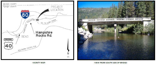 In October 2012, it was reported
that two 1926 bridges along old US 40 were scheduled for replacement: the
Hampshire Rocks Road bridge over the South Yuba River near Big Bend, and
the Donner Pass Road bridge over the S. Yuba River . The latter project is
between exits 165 and 171 off I-80 (and is a bit E of the first project).
In October 2012, it was reported
that two 1926 bridges along old US 40 were scheduled for replacement: the
Hampshire Rocks Road bridge over the South Yuba River near Big Bend, and
the Donner Pass Road bridge over the S. Yuba River . The latter project is
between exits 165 and 171 off I-80 (and is a bit E of the first project).
 Alternate Routes
 There was also an Alternate US 40, signed in 1954. This ran N from 2
mi SW of Davis beginning at the current interchange of I-80 and Pedrick
Road (Yolo County Road 98). It then followed Pedrick Road north past the
UC Davis airport to Russell Boulevard, then followed Russell east to Route 113, where it met up with US 99W northbound and continued to Woodland (LRN 7 between US 40 and Route 16; LRN 87 between Route 16 and Tudor); then
along present-day Route 70 between Marysville and US 395 (LRN 87 between
Marysville and Oroville; LRN 21 between Oroville and US 395). It was
cosigned with US 395 into Reno, NV.
In 1954, Sign Route 24 was either co-signed or resigned as Alt US 40
(US 40A). The article announcing the designation indicated that existing
signs would be replaced by US 40 signs with the designation "Alt". The
article indicated that for the first 10 miles N, from US 40 in Solano
County, the new alternate route would be designated as US 99W and US 40A.
A new section of highway was being constructed to intersect with the
existing US 99W at the Woodland Wye. This would be the segment that is now
Route 113. In Woodland, US40A joined with the existing US 99W / Sign Route 24 to Yuba City; this is now Route 113. US 40A then followed Sign Route 24
(now Route 70) through Oroville and Quincy to US 395. Lastly, US 40A
followed US 395 S to Reno, which was the eastern terminus of US 40A. The
goal here was to provide an alternate route across the Sierras when Donner
Pass was closed.
(Source: Roseville Press-Tribune 3/23/1954 via Joel Windmiller
(email), 11/12/2023)
In the late 1930s, there was a temporary routing of Alternate US 40 that took a more southern alignment than the current Route 70 routing, running through Berry Creek and Bucks Lake to Quincy along Orville-Quincy Highway, Spanish Ranch, and Bucks Lake Road. Much of that route is no longer part of the state highway system, although the portion from Oroville to Brush Creek is part of Route 162.
Note that the routings in Davis had been changed to the Route 113 routing by 1953.
 Freeway
 In July 1955, the Auburn Journal published an article on the proposed freeway
routings between Roseville and Newcastle. It noted:
In July 1955, the Auburn Journal published an article on the proposed freeway
routings between Roseville and Newcastle. It noted:
(Source: Joel Windmiller, California's Historic Highways on FB, 6/1/2020)
Officials, Civic Groups, Urged To Attend Public Meeting July 13th. Studies for the future freeway routing of US. 40 between one-half mile east of Roseville and one mile east of Newcastle have now reached a stage which permits tentative conclusions as to basic plan, District Engineer A. M. Nash of the State Division of Highways announced today. Nash said that State Highway Engineer Q T. McCoy has requested the district to hold a public meeting to explain the various route and the conclusions reached by the engineers. Preliminary discussions have been held with local authorities to arrange for such a meeting in Auburn on July 13 1955 at 2 p. m. in the Little Theater at Siena College. The Division of Highways urges all interested officials, individuals, and civic groups to attend the meeting and to present any Information pertinent to the route determination. The information may be furnished orally, or written statements may be filed with the Division. The studies by the Division of the various possible routings between Roseville and Newcastle Include all of the numerous factors which influence the location of a highway through developed and semi-developed areas. These factors involve traffic service, cost of construction, and right of way, location of schools, future development, and overall effect on the area. In addition to local conditions Nash also pointed out that all route studies on U. S. 40 have to take into consideration the importance of the road as a main trans-continental highway, as well as its being a part of the federal government interstate highway system. On a map furnished by Nash for publication, the various possible routes for U. S. 40, that have been given the most serious consideration are shown. All of the routes start one-half mile east of Roseville at the easterly end of the Sacramento to Roseville freeway that is now under construction. The end one mile east of Newcastle at the westerly end of the proposed Newcastle Auburn freeway for which the route was adopted by the Highway Commission in November of 1953. The possible routes between Roseville and Newcastle are shown on the Division of Highways map. Route "A" departs from the existing road one-half mile east of Roseville and continues along Secret Ravine, south of Rocklin, Loomis, and Penryn. Near the end of Secret Ravine, the line turns north. and rejoins the existing road one mile east of Newcastle a distance of approximately 11 miles. All of the other routes generally follow existing various proposals for going through or around Rocklin and Loomis. The necessity for improving U. S. 40 to a multi-lane freeway between San Francisco and the Nevada state line has been widely publicized during the past few years. The strategic importance of the road in the event of a national emergency has been emphasized repeatedly. With, the adoption of this section by-the highway commission U. S. 40 will have been declared a continuous freeway from San Francisco to approximately 9 miles east of Colfax except for a short section through the city of Sacramento. After the public explanation of the route studies between Roseville and Newcastle has been accomplished a report of the data and conclusions, including information furnished by interested persons attending the meeting, will be forwarded by Nash to State Highway Engineer G. T.. McCoy. McCoy will furnish the report and his recommendation for routing to the California Highway Commission. Route adoption is the responsibility of the commission. It is the policy of the commission to offer the opportunity for a public hearing "by the commission itself if the local authorities so desire.
Within the city of Colfax, what would become US 40 was part of LRN 37,
which in turn was part of the original Dutch Flat and Donner Lake Wagon
Road (DF&DLWR). The DF&DLR was adopted as state highway as part of
the Emigrant Gap State Road in 1909 under Legislative Chapter 224 with the
following description: "An act to make an appropriation for the location,
survey and construction of a state highway from Emigrant Gap...to the west
end of Donner Lake..." […] "...for the location, survey, and
construction of a state highway from Emigrant Gap, Placer County in an
E-ly direction through what is known as the Truckee Pass (Donner Pass) to
the W end of Donner Lake in Nevada County... and it shall be the duty of
the department to locate, survey, and construct said road along the line
of the wagon road known as the Dutch Flat and Donner Lake wagon road...".
After the creation of the US Highway system in 1926, LRN 37 became part of
US 40. Eastbound US 40 crossed through Colfax via Auburn Street, Grass
Valley Street and Main Street. In 1939, a new US 40/LRN 37 bypass route of
Colfax was constructed that included a rail overpass. In 1955, an
expressway realignment of US 40/LRN 37 from Heather Glen to Colfax and
Colfax to Gold Run was budgeted for the 1956-57 Fiscal Year. On April 24,
1956., this opened as the Ben Ali-Roseville Freeway as a new alignment US 99E/US 40/LRN 3. US 99E was rerouted from the end of the Elvas Freeway
along the Ben Ali-Roseville Freeway to the Riverside Avenue Exit.
The Newcastle-Auburn freeway, Heather Glen-Colfax expressway, Colfax-Magra
expressway and Floriston-Nevada State Line expressway were subsequently
budgeted for future realignments of US 40. In 1958, a number of
additional freeway segments opened: the Newcastle-Auburn segment, the
Heather Glen-Colfax segment, the Colfax-Magra segment, and the
Boca-Stateline segment. Additional segments opened in 1959.
(Source: Gribblenation Blog (Tom Fearer), "Former US Route 40 in Colfax", 2/3/2022)
 In March 1956, the Sacramento Bee published information on the proposed
freeway route in the vicinity of Gold Run. The final adoption of the
routes was expected to be made by the California Highway Commission at a
meeting in April 1956. The article noted:
In March 1956, the Sacramento Bee published information on the proposed
freeway route in the vicinity of Gold Run. The final adoption of the
routes was expected to be made by the California Highway Commission at a
meeting in April 1956. The article noted:
(Source: Joel Windmiller, California's Historic Highways on FB, 6/1/2020)
Contracts To Be Let On 17 Miles Of Freeway. On US Highway 40 Bids will be opened and contracts let to start construction this year on U. S. Highway 40 between Heather Olen and Colfax, between Colfax and Maura and between Floriston and the Nevada State line, it was announced by J. W. Trask, district engineer of the State Division of Highways. In addition, a contract to be let for construction. structure! between Newcastle and Auburn at an estimated cost of $1,300,000 will also get underway this year, Trask stated. The first three stretches of multi-lane freeway total about 17 miles, with an estimated construction cost of 9,750,000. The necessity for improving US 40 to multi-lane freeway from San Francisco to the Nevada state line has received considerable publicity in the past few years. On February,14 a public meeting was held In Auburn to discuss the section between Magra west of Gold Run and Blue Canyon Road, a distance of 14 miles, and the section between Hampshire Rocks to Soda Springs, a distance of 6 miles.
 In October 1956, the Reno Gazette Journal published information on proposed
routings of US 40 (future I-80) in the Sierra Nevada area. The map to the
right is excepted from the article; it shows the tentatively planned route
from east of Donner Lake over the Sierra summit north of the present
Donner pass and on to a point just west of Soda Springs, a distance of
10.3 miles. The lower map shows the proposed freeway segment further west,
beginning at Hampshire Rocks and continuing for 13.6 miles to the Blue
Canyon turnoff, just west of Emigrant Gap. The routing for the segment
between the two areas shown above has already been adopted by the
California Highway Commission." The routing was described as follows:
In October 1956, the Reno Gazette Journal published information on proposed
routings of US 40 (future I-80) in the Sierra Nevada area. The map to the
right is excepted from the article; it shows the tentatively planned route
from east of Donner Lake over the Sierra summit north of the present
Donner pass and on to a point just west of Soda Springs, a distance of
10.3 miles. The lower map shows the proposed freeway segment further west,
beginning at Hampshire Rocks and continuing for 13.6 miles to the Blue
Canyon turnoff, just west of Emigrant Gap. The routing for the segment
between the two areas shown above has already been adopted by the
California Highway Commission." The routing was described as follows:
(Source: Joel Windmiller, California's Historic Highways on FB, 6/1/2020)
Division Engineer Trask explained the Emigrant Gap-Hampshire Rocks routing as follows: "The tentative routing of this portion of US 40 begins at Blue Canyon road at the easterly end of the previously adopted freeway between Magra and Blue Canyon road, and generally follows the existing alignment to a point west of Cisco. There it crosses the south fork of the Yuba River and proceeds in an easterly direction south of the river. West of Big Bend ranger station the line crosses the south fork of the Yuba again, travels northeasterly of the present highway, and terminates at Hampshire Rocks, which is the westerly end of the adopted relocation between Hampshire Rocks and Soda Springs."
 In March 1956, the Sacramento Bee published information
on the proposed freeway route in the vicinity of Kingvale. The final
adoption of the routes was expected to be made by the California Highway
Commission at a meeting in April 1956.
In March 1956, the Sacramento Bee published information
on the proposed freeway route in the vicinity of Kingvale. The final
adoption of the routes was expected to be made by the California Highway
Commission at a meeting in April 1956.
(Source: Joel Windmiller, California's Historic Highways on FB, 6/1/2020)
 In October 1956, the Reno Gazette Journal published information on proposed
routings of US 40 (future I-80) in the Sierra Nevada area. The map to the
right is excepted from the article; it shows the proposed freeway segment
beginning at Hampshire Rocks and continuing for 13.6 miles to the Blue
Canyon turnoff, just west of Emigrant Gap." The routing was described as
follows:
In October 1956, the Reno Gazette Journal published information on proposed
routings of US 40 (future I-80) in the Sierra Nevada area. The map to the
right is excepted from the article; it shows the proposed freeway segment
beginning at Hampshire Rocks and continuing for 13.6 miles to the Blue
Canyon turnoff, just west of Emigrant Gap." The routing was described as
follows:
(Source: Joel Windmiller, California's Historic Highways on FB, 6/1/2020)
Division Engineer Trask explained the proposed routing of the Soda Springs-Truckee "Y" freeway as follows: "(The routing) begins at the easterly end of the previously adopted route between Hampshire Rocks and Soda Springs, crossing the existing road west of and passing to the north of Soda Springs. It then continues in a northeasterly direction passing approximately 1.75 miles north of Donner Summit in the vicinity of the West Lakes From this point, the proposed alignment continues to the westerly end of the previously adopted relocation between 1.3 miles west of the junction of US 40 and Route 89."
 In March 1956, the Sacramento Bee published information on the proposed freeway
routes in the vicinity of Truckee. The final adoption of the routes was
expected to be made by the California Highway Commission at a meeting in
April 1956. The article noted:
In March 1956, the Sacramento Bee published information on the proposed freeway
routes in the vicinity of Truckee. The final adoption of the routes was
expected to be made by the California Highway Commission at a meeting in
April 1956. The article noted:
(Source: Joel Windmiller, California's Historic Highways on FB, 6/1/2020)
Trask announced today that preliminary studies for a future freeway on 16 miles of US 40 in Nevada County between the east end of Donner Lake and Floriston have now reached the stage which permits a tentative conclusion as to basic plan. State Highway Engineer O. T. McCoy has Instructed Trask to hold a public meeting to explain the various studies and the tentative conclusions reached by the engineers. The meeting will be held in Truckee on April 7 at 10 a.m. In the Truckee high school cafeteria. Trask urged all interested individuals and civic groups to attend the meeting and to present any information which may be pertinent to a freeway routing for the portion of US 40 concerned. This information may be delivered orally, or a written statement may be filed with the division of highways. The studies by the division of the proposed route from the east end of Donner Lake to Floriston include all of the numerous factors influencing the location of a highway through developed and seml-developed areas. The factors involved Include traffic service, cost of construction, and right of way, location of schools, future developments, and over-all effect oo the area, including the town of Truckee. ". 7 Mr. Trask also stated that in addition to local conditions all route studies on US 40 have to consider the importance of the road as a main transcontinental highway and a part of the federal government interstate highway system. The tentative routing would depart from the existing road, a short distance east of Donner Lake, pass to the north of both the town of Truckee and the Truckee airport, and rejoin the existing road west of Boca. Just east of Boca, the tentative routing leaves the existing highway again, rejoining it southwest of Floriston. The tentative routing eliminates many of the sharp curves in the Truckee River canyon. After a public explanation of the route studies between Donner Lake and Floriston has been given a report of the data and conclusions, including information furnished by interested persons attending the meeting, will be forwarded by Trask to State Highway Engineer McCoy. McCoy will furnish the information and his .recommendation for routing to the California, highway commission. Route adoption is the responsibility of the; commission.
 Status
There is a sign at the western end of the route that indicates the distance to Wilmington NC (~ SBD 0.559). The sign was once stolen, but has since been replaced.
In September 2011, it was reported that San Bernardino County received $35,912,000 to rehabilitate 93 roadway lane miles and extend pavement service life and improve ride quality near Newberry Springs on I-40 (~ SBD R28.5 to SBD R50.012). The scope of work is between the Desert Oasis Safety Roadside Rest Area and Crucero Road. The project will grind and overlay mainline, shoulders and ramps. It will also upgrade metal beam guardrail and minor drainage.
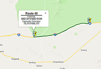
Ludlow Cross Slope Rehabilitation (08-SBd-40, PM R75/R100)
 In October 2018, the CTC
approved for future consideration of funding the following project for
which a Mitigated Negative Declaration (MND) has been completed: I-40 in
San Bernardino County (08-SBd-40, PM R75/R100). Regrade median cross
slopes on a portion of I-40 near the town of Ludlow. (PPNO 3001R) This
project is located on I- 40 near the town of Ludlow in San Bernardino
County. The project proposes to regrade the existing median cross slopes
within the 30 foot clear recovery zone from a steeper gradient to a
flatter gradient. Also included in the proposed project will be the
extension of existing culverts, upgrading of guardrail and establishing
California Highway Patrol crossings in the median. The proposed project
will address the need to improve the recovery zones and reduce the risk of
out of control vehicles crossing the median and colliding with opposing
traffic. The proposed project is estimated to cost approximately $38.4
million. This project is currently funded and programmed in the 2018 SHOPP
for approximately $38.4 million. Construction is estimated to begin in
2020. The scope, as described for the preferred alternative, is consistent
with the project scope programmed by the Commission in the 2018 SHOPP.
In October 2018, the CTC
approved for future consideration of funding the following project for
which a Mitigated Negative Declaration (MND) has been completed: I-40 in
San Bernardino County (08-SBd-40, PM R75/R100). Regrade median cross
slopes on a portion of I-40 near the town of Ludlow. (PPNO 3001R) This
project is located on I- 40 near the town of Ludlow in San Bernardino
County. The project proposes to regrade the existing median cross slopes
within the 30 foot clear recovery zone from a steeper gradient to a
flatter gradient. Also included in the proposed project will be the
extension of existing culverts, upgrading of guardrail and establishing
California Highway Patrol crossings in the median. The proposed project
will address the need to improve the recovery zones and reduce the risk of
out of control vehicles crossing the median and colliding with opposing
traffic. The proposed project is estimated to cost approximately $38.4
million. This project is currently funded and programmed in the 2018 SHOPP
for approximately $38.4 million. Construction is estimated to begin in
2020. The scope, as described for the preferred alternative, is consistent
with the project scope programmed by the Commission in the 2018 SHOPP.
(Source: October 2018 CTC Agenda Item 2.2c.(1))
In December 2018, it was reported that Caltrans was
beginning a safety project on I-40 to improve the slope of the median near
the city of Ludlow, between Crucero Road and Badger Wash. Construction
will being on January 7, 2019. Work will be done on both east and west
bound I-40, from 6:00 a.m. to 6:00 p.m. Monday through Thursday, and from
6:00 a.m. to 5:00 p.m. Saturday and Sunday. This $33.9-million safety
project is expected to last for approximately one year.
(Source: Caltrans Press Release, 12/28/2018)
Van Winkle Wash Bridges (~ R085.19)
In June 2012, the CTC approved for future consideration of funding a project that will replace Van Winkle Wash Bridge Left and Right (Bridge Numbers 54-0903L and 54-0903R) on I-40 near Essex to correct extensive deck and girder cracking. The project is programmed in the 2010 State Highway Operation and Protection Program (SHOPP). The total estimated project cost is $21,697,000 for capital and support. Construction is estimated to begin in Fiscal Year 2012-13. The scope, as described for the preferred alternative, is consistent with the project scope programmed in the 2010 SHOPP.
In August 2012, the CTC approved SHOPP funding of $11,615,000 on I-40 PM R85.2 near Essex, at Van Winkle Wash Bridges (Bridge # 54-0903L/R). Outcome/Output: Replace both eastbound and westbound bridges to address extensive cracking and ensure long-term operational capability.
Hoff Wash Bridges (~ R093.60)
 In June 2014, the CTC authorized for future consideration of funding a project in San Bernardino
County that will replace the existing Hoff Wash Bridge on I-40 near the
town of Ludlow. The project is programmed in the 2014 State Highway
Operation and Protection Program. The total estimated cost is $13,390,000
for capital and support. Construction is estimated to begin in Fiscal Year
2015-16. They also authorized for future consideration of funding a
project in San Bernardino County that will replace the left side of the
existing Watson Wash Bridge on I-40 near the Goffs Road overcrossing. The
project is programmed in the 2014 State Highway Operation and Protection
Program. The total estimated cost is $13,478,000 for capital and support.
Construction is estimated to begin in Fiscal Year 2015-16. Lastly, they
also approved, again for future consideration of funding, a project in San
Bernardino County that will replace the existing Haller Wash Bridges, Rojo
Wash Bridges, and Clipper Valley Wash Bridges and construct a temporary
concrete batch plant site in the median of I-40. The project is programmed
in the 2012 State Highway Operation and Protection Program. The total
estimated cost is $41,059,000 for capital and support. Construction is
estimated to begin in Fiscal Year 2014-15.
In June 2014, the CTC authorized for future consideration of funding a project in San Bernardino
County that will replace the existing Hoff Wash Bridge on I-40 near the
town of Ludlow. The project is programmed in the 2014 State Highway
Operation and Protection Program. The total estimated cost is $13,390,000
for capital and support. Construction is estimated to begin in Fiscal Year
2015-16. They also authorized for future consideration of funding a
project in San Bernardino County that will replace the left side of the
existing Watson Wash Bridge on I-40 near the Goffs Road overcrossing. The
project is programmed in the 2014 State Highway Operation and Protection
Program. The total estimated cost is $13,478,000 for capital and support.
Construction is estimated to begin in Fiscal Year 2015-16. Lastly, they
also approved, again for future consideration of funding, a project in San
Bernardino County that will replace the existing Haller Wash Bridges, Rojo
Wash Bridges, and Clipper Valley Wash Bridges and construct a temporary
concrete batch plant site in the median of I-40. The project is programmed
in the 2012 State Highway Operation and Protection Program. The total
estimated cost is $41,059,000 for capital and support. Construction is
estimated to begin in Fiscal Year 2014-15.
In January 2016, the CTC approved SHOPP funding in San Bernardino County, on I-40 near Essex, from 0.3 mile west to 0.4 mile east of Hoff Wash Bridge (No. 54-0889L/R). Outcome/Output: Replace two bridges due to cracking on bridge deck, wing/pier walls and concrete barrier railing. Future Consideration of Funding approved under Resolution E-14-23; June 2014. $8,036,000.
Halfway Hills Wash Bridges Scour Replacement/Mitigation (08-SBd-40, PM R100.8/R101.8)
 In December 2020, the CTC amended the 2020 SHOPP to revise the following project as
indicated: 08-SBd-40 PM 101.3 PPNO 08-3008K ProjID 0816000079 EA 1G830.
I-40 Near Needles, at the Halfway Hills Wash Bridge №54-0799L/R.
In December 2020, the CTC amended the 2020 SHOPP to revise the following project as
indicated: 08-SBd-40 PM 101.3 PPNO 08-3008K ProjID 0816000079 EA 1G830.
I-40 Near Needles, at the Halfway Hills Wash Bridge №54-0799L/R. Retrofit
bridge footings, Replace bridges, replace and expand
Rock Slope Protection (RSP) limits. Programmed allocation changes (in
thousands): Con Sup $2,538 $4,776; Const Cap $9,652
$15,880; Total $15,571 $24,037. Note:
The scope of this project is changing from scour mitigation to bridge
replacement because the scour specialist determined that the previous
strategy of micro piles should not be used in soils susceptible to
liquefaction and bridge replacement would be a preferred strategy.
Increase construction support because more working days will be required
and increase construction capital because of the additional costs involved
in bridge replacement.
(Source: December 2020 CTC Agenda, Agenda Item
2.1a.(1d) #17)
In March 2021, the CTC authorized the following project
for future consideration of funding: 08-SBd-40, PM R100.8/R101.8. Interstate 40 Bridge Scour Mitigation. Replace Halfway Hills Wash Bridges on
I-40 in San Bernardino County. (MND) (PPNO 3008K) (SHOPP). This project is
located in the County of San Bernardino near the town of Essex at 1.6
miles east of Essex Road Overcrossing to 5.6 miles west of Goffs Road
Undercrossing. The Department proposes to mitigate the scour underneath
the Halfway Hills Wash Bridge on I-40. This project is not fully funded
and is currently programmed in the 2020 SHOPP for a total of $24,037,000
of which $20,656,000 is currently through G-13 Contingency. Construction
is estimated to begin in Fiscal Year 2022-23. The scope, as described for
the preferred alternative, is consistent with the project scope programmed
by the Commission in the 2020 SHOPP. A Mitigated Negative Declaration
(MND) has been completed. The project will result in less than significant
impacts to the environment after mitigation. The following resource
areas may be impacted by the project: biological resources, cultural
resources, greenhouse gas emissions, hydrology and water quality, noise,
and traffic and transportation. Avoidance and minimization measures
will reduce any potential effects on the environment. These measures
include, but are not limited to, compensatory mitigation for impacts to
desert tortoise habitat and hydrology, development and implementation of a
traffic management plan, and inclusion of contract noise control
provisions to reduce noise during construction.
(Source: March 2021 CTC Agenda, Agenda Item
2.2c.(1))
Also in March 2021, the CTC approved the following
pre-construction SHOPP SB1 support phase allocation(s): (2b) #13.
$2,188,000 (PS&E, $1,903,000 programmed); $56,000 (R/W Sup, $55,000
programmed). 08-SBd-40 101.3. PPNO 08-3008K; ProjID 0816000079; EA 1G830.
I-40 Near Needles, at the Halfway Hills Wash Bridge №
54-0799L/R. Replace bridges, replace and expand Rock Slope
Protection (RSP) limits. (Concurrent consideration of funding under
Resolution E-21-29; March 2021.) Prog. year 21-22.
(Source: March 2021 CTC Agenda, Agenda Item
2.5b.(2b) #13)
In June 2022, the CTC approved the following
construction phase SHOPP allocation: $23,789,000. 08-SBd-40 R100.8/R101.8.
PPNO 08-3008K; ProjID 0816000079; EA 1G830. I-40 Near Needles, at the
Halfway Hills Wash Bridge № 54-0799L/R. Outcome/Output:
Replace bridges and replace and expand Rock Slope Protection (RSP) limits
to prevent bridge failure and ensure safety. Future consideration of
funding approved under Resolution E-21-29; March 2021. Concurrent
Amendment under SHOPP Amendment 22H-002; June 2022. Allocation: CON ENG
$4,776,000; CONST $15,880,000.
(Source: June 2022 CTC Agenda, Agenda Item 2.5b.(1)
#32)
In January 2023, the CTC approved a request for an
additional $2,905,000 in Construction Capital for the SHOPP Bridge
Replacement project on I-40, in San Bernardino County (08-SBd-40 101.3.
PPNO 08-3008K; ProjID 0816000079; EA 1G830), to award the construction
contract. This project is located on I-40 near the City of Needles, at the
Halfway Hills Wash Bridge (№ 54-0799L/R), in San Bernardino
County. The project will replace the existing bridges and rock slope
protection (RSP), and install additional RSP to expand the RSP limits. In
March 2018, the project was programmed for $9,652,000 in Construction
Capital in the SHOPP for allocation in Fiscal Year 2021-22. In December
2020, the project was amended to increase the Construction Capital to
$15,880,000. In June 2022, the project was amended to program the unfunded
G-13 Contingency construction phases for $15,880,000 in Construction
Capital and allocated for $18,589,000 in Construction Capital. Bids were
opened in October 2022, and the amount required to award to the lowest
bidder exceeded the amount available from project allocated and G-12
funds. Therefore, the Department is requesting supplemental funds in
the amount of $2,905,000 to award the construction contract. In December
2022, the project received a 6-month award time extension. In August 2022,
the Department advertised the contract and held bid opening in October
2022. The contract received three bids, of which the lowest bid is 16.2
percent above the Engineer’s Estimate (EE). The two remaining
bids are 20.8 and 28.3 percent over the EE. The cost increases on this
project are largely attributed to recent spike in oil prices and higher
transportation costs for ready mix concrete. The project is located
approximately 100 miles from the nearest commercial supplier of concrete
and asphalt. The major unit price differences, between the EE and
lowest responsible bid, are related to the following bid items: •
Hot Mix Asphalt (Type A) - 105 percent higher ($2,116,000) •
Structural Concrete, Bridge - 170 percent higher ($738,000). In aggregate,
these items amount to an increase of $2,854,000 over the EE. The remaining
increase is due to minor unit price cost increases of other bid items.
(Source: January 2023 CTC Agenda, Agenda Item 2.5e.(9))
In March 2019, the CTC approved for future consideration of funding a
project on I-40 near the city of Needles in San Bernardino County, east of
Homer Wash Bridge to the California/Arizona border (08-SBd-40, PM
R125/R154.6). The project proposes to re-grade the existing non-standard
median. The project proposes to address the safety of the traveling public
by reducing the number and severity of collisions in the existing median.
This project is fully funded and currently programmed in the 2018 SHOPP
for approximately $32.3 million. Construction is estimated to begin in
Fiscal Year 2019-20. The scope, as described for the preferred
alternative, is consistent with the project scope programmed by the
Commission in the 2018 SHOPP. They also provided a support allocation of
PS&E $2,300,000 and R/W Sup $200,000 (2.5b.(2a)).
(Source: March 2019 CTC Minutes, Agenda Item 2.2c.(1))
In January 2018, it was reported that paper signs placed over the
existing sign that listed emergency contact information and phone numbers
on the "Welcome to California" signs at the border (~ SBD R154.493) had
been removed. The signs, first noticed by a handful of Twitter users, read
"Official Sanctuary State," and "Felons, Illegals, and MS13 Welcome!
Democrats Need The Votes!" California became a sanctuary state on January
1, 2018, following a bill signed by Governor Jerry Brown in October. The
bill prevents state law enforcement officers from inquiring about a
person's immigration status, from arresting persons because of civil
immigration warrants, or from participating in a joint task force with
federal officials to enforce immigration laws. The intent is to not
discourage undocumented immigrants from working with law enforcement due
to fear that their cooperation would get them deported. One sign was found
and promptly removed Monday on Interstate 15 near Mountain Pass, just west
of the California-Nevada border. Another was removed from I-40 in the
Needles area near the California-Nevada border. Caltrans has also received
unconfirmed reports of up to three more fake signs — two of which
are reported to be near the Oregon border — but they have not yet
been able to verify the existence of those. The Twitter photo included a
white paddle indicating at least one sign was on Route 95 near Palm
Gardens (the paddle shows "CL", likely referring to Clark County, and the
point where US 95 transitions from California to Nevada).
(Source: SFGate, 1/2/2018; Snopes, 1/2/2018)
 Colorado River Bridge (08-San Bernardino-40 PM
153.9/154.7)
Colorado River Bridge (08-San Bernardino-40 PM
153.9/154.7)
The following project was included in the final adopted 2018 SHOPP as a "Long Lead Project" in March 2018: PPNO 3001S. 08-San Bernardino-40 153.9/154.7. I-40 Near Needles, from Park Moabi Road
to Topock Road at the Colorado River Bridge № 54-0415. Bridge
rehabilitation and/or replacement. Caltrans will be the lead agency and
will share half of all costs with ADOT as indicated via a signed Letter of
Intent. Note: Complexity of environmental and geotechnical investigations.
Extensive coordination required with Arizona resource agencies. *
PA&ED phase(s) is authorized. Begin Con: 4/15/2024. Total Project
Cost: $44,141K.
(Image source: Colorado River Bridge Project Website)
The 2020 SHOPP, approved in May 2020, included the
following Long Lead Bridge Preservation item of
interest (carried over from the 2018 SHOPP): 08-San Bernardino-40 PM
153.9/154.7 PPNO 3001S Proj ID 0812000067 EA 0R380. I-40 near Needles,
from Park Moabi Road to Topock Road at the Colorado River Bridge №
54-0415. Bridge rehabilitation and/or replacement. Caltrans will be the
lead agency and will share half of all costs with Arizona Department of
Transportation (ADOT) as indicated via a signed Letter of Intent. Note:
Complexity of environmental and geotechnical investigations. Extensive
coordination required with Arizona resource agencies. Programmed in
FY24-25, with construction scheduled to start at the end of January 2026.
Total project cost is $44,141K, with $28,969K being capital (const and
right of way) and $15,172K being support (engineering, environmental,
etc.). Only the PA&ED allocation of $2,650K was authorized.
(Source: 2020 Approved SHOPP a/o May 2020)
In November 2020, scoping meetings were held for the
Colorado River Bridge replacement project. The California Department of
Transportation (Caltrans), in cooperation with the Arizona Department of
Transportation (ADOT), proposes to replace the Colorado River Bridge
(California Bridge № 54-0415, Arizona Bridge № 957) spanning
the California/Arizona state line on I-40. The purpose of the
project is to improve the safety and integrity of the bridge by addressing
deck deterioration and strengthening the girders to increase the load
rating to accommodate all permitted vehicle traffic. The three Build
Alternatives under consideration would either replace the bridge north,
south, or on the existing bridge alignment, in addition to a No-Build
Alternative. It is expected that the safety of the traveling public would
be enhanced by introducing standard lane and shoulder widths, a standard
median barrier, and a standard bridge railing system. Depending on the
alternatives, the estimated ROW Cost is $169,000 to $695,000, and the
estimated Construction Cost is $55.1 to $71.1 Million. Specifics of the
alternatives are as follows:
(Source: Colorado River Bridge Project Website)
In June 2021, the CTC approved the following SHOPP
amendment: 08-SBd-40 153.9/154.7. PPNO 3001S ProjID 0812000067 EA
08-0R380. I-40 Near Needles, from Park Moabi Road to Topock Road at the
Colorado River Bridge № 54-0415. Bridge rehabilitation and/or
replacement. Caltrans will be the lead agency and will share half of
all costs with Arizona Department of Transportation (ADOT) as indicated
via a signed Letter of Intent. Note: Delay delivery schedule to FY25-26
because geotechnical studies can't be performed during PA&ED, as they
require permit approval by California Department of Fish and Wildlife
(CDFW). The Department will instead conduct these investigations
during PS&E, and will push out the RTL milestone. Update square
footage of bridge performance based on the anticipated preferred
alternative.
(Source: June 2021 CTC Agenda, Agenda Item
2.1a.(2f) #2)
 Naming
This route is named the "Needles Freeway". It was named by Senate Concurrent Resolution 1 in 1968. It was named because it traverses the City of Needles. Needles was named after a railroad station, established in February 1883, on the Arizona side of the Colorado River and named after the near-by pinnacles. The name was transferred to the California side in October 1883.
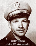 The portion of I-40 between West Park Road (SBD 139.18)
and the Needles Overcrossing (SBD 142) in the County of San Bernardino is
named the "CHP Officer John “Jack” Armatoski Memorial
Highway". It was named in memory of Officer John "Jack" Walter
Armatoski, who was born on May 1, 1917, to August and Sophie, in Ironwood,
Michigan. Upon graduation from the CHP Academy in 1948, Officer Armatoski
was assigned to the Needles area. Officer Armatoski was killed in the line
of duty on May 1, 1953, during a routine traffic stop on US 66 near
Needles. After he completed the traffic citation, Officer Armatoski was
approaching the violator's car on the left side when an intoxicated
motorist, driving a stolen station wagon, sideswiped the parked vehicle
and struck Officer Armatoski, killing him instantly. Officer Armatoski was
a devoted officer, a loyal husband, and an amazing father. He was known
for his integrity and his adoration of his wife and children.Named by
Assembly Concurrent Resolution 100, Resolution Chapter 109, on September
4, 2012.
The portion of I-40 between West Park Road (SBD 139.18)
and the Needles Overcrossing (SBD 142) in the County of San Bernardino is
named the "CHP Officer John “Jack” Armatoski Memorial
Highway". It was named in memory of Officer John "Jack" Walter
Armatoski, who was born on May 1, 1917, to August and Sophie, in Ironwood,
Michigan. Upon graduation from the CHP Academy in 1948, Officer Armatoski
was assigned to the Needles area. Officer Armatoski was killed in the line
of duty on May 1, 1953, during a routine traffic stop on US 66 near
Needles. After he completed the traffic citation, Officer Armatoski was
approaching the violator's car on the left side when an intoxicated
motorist, driving a stolen station wagon, sideswiped the parked vehicle
and struck Officer Armatoski, killing him instantly. Officer Armatoski was
a devoted officer, a loyal husband, and an amazing father. He was known
for his integrity and his adoration of his wife and children.Named by
Assembly Concurrent Resolution 100, Resolution Chapter 109, on September
4, 2012.
(Image source: California Assn of Highway Patrolmen)
 Named Structures
This route also has the following Safety Roadside Rest Areas:
It was named in memory of Caltrans Highway Superintendent for the
Needles area, John Wilkie, who sought ways to improve maintenance at
this Rest Area. Pursuing this goal, John became a statewide leader in
increasing employment opportunities for persons with disabilities.
John's passionate belief in the abilities of people let him to develop
and promote the "Roads as Bridges to Employment" program. Today,
throughout California, Rest Areas are maintained by persons with
disabilities. John represented the highest ideals of public service,
continuing long beyond his retirement to be a mentor and champion for
persons with disabilities. 1928–1997.
(Background source: Historical Marker Database)
 Business Routes
 Historical Route
This route is part of "Historic Highway Route 66", designated by Assembly Concurrent Resolution 6, Chapter 52, in 1991.
Assembly Concurrent Resolution 180, 1998, designated those portions of US 40 that are still publicly maintained and not already designated as part of Historic US 40 as "Historic US 40".
Senate Concurrent Resolution 66, Chaptered May 18, 2006 (Resolution Chapter 51), designated, upon application by an appropriate local governmental agency, any section of former Alternate U.S. Highway Route 40 that is still a publicly maintained highway and that is of interest to the applicant, as Historic Alternate U.S. Highway Route 40. This recognizes the role that Former Alternate U.S. Highway Route 40 played in the development of the transportation routes into California over what is now known as the Davis "Y". Alternate U.S. Highway Route 40 is currently Route 113 from Davis to Woodland and Yuba City, and Route 70 through Marysville, Oroville, and the Feather River Canyon to Hallelujah Junction on Route 395, a route that today serves 27 towns and the six counties of Yolo, Sutter, Yuba, Butte, Plumas, and Lassen. The Feather River Scenic Byway is a 130 mile segment of Route 70, which was part of Alternate U.S. Highway Route 40.
 Interstate Submissions
Approved as chargeable Interstate on 7/7/1947. In August 1957, this was tentatively approved as I-40; however, in November 1957 the California Department of Highways suggested that it be designated as I-30 to eliminate confusion with the existing US 40 in California. This was rejected by AASHTO, and was probably one of the factors leading to the "great renumbering".
 Classified Landcaped Freeway
The following segments are designated as Classified Landscaped Freeway:
| County | Route | Starting PM | Ending PM |
| San Bernardino | 40 | 0.56 | 0.90 |
| San Bernardino | 40 | R141.09 | R142.21 |
| San Bernardino | 40 | R142.28 | R142.53 |
| San Bernardino | 40 | R143.48 | R143.76 |
 Scenic Route
[SHC 263.4] From Barstow to Needles.
 Blue Star Memorial Highway
This route (I-40) was designated as a "Blue Star Memorial Highway" by Assembly Concurrent Resolution 112, Ch. 143 in 1984.
 Interregional Route
[SHC 164.12] Entire route
 National Trails
  The original surface routing replaced by I-40 (i.e., old US 66) was part of the "National Old Trails Road".
 The original surface routing replaced by I-40 (i.e., old
US 66) was part of the "Santa Fe Trail".
The original surface routing replaced by I-40 (i.e., old
US 66) was part of the "Santa Fe Trail".

 The original surface routing replaced by I-40
(i.e., old US 66) appears to have been part of the "National Park to
Park Highway", and the "Pikes Peak Ocean to Ocean Highway".
The original surface routing replaced by I-40
(i.e., old US 66) appears to have been part of the "National Park to
Park Highway", and the "Pikes Peak Ocean to Ocean Highway".
 As US 40, the portion of this route between the Nevada
border and Sacramento was part of the "Lincoln Highway (Alternate)"
(which started in Reno). The Lincoln Highway was also routed along US 50.
As US 40, the portion of this route between the Nevada
border and Sacramento was part of the "Lincoln Highway (Alternate)"
(which started in Reno). The Lincoln Highway was also routed along US 50.
Additionally, the segment of US 40 between San Francisco
and Oakland was part of the "Lincoln Highway", which originally
terminated in Lincoln Park, six miles west of the ferry landing at the
foot of Market Street. The Lincoln Highway ended opposite the Palace of
the Legion of Honor at a small monument marking the spot. The last few
miles (of the highway) were California Street.
 Portions of US 40 were part of the "Victory Highway".
 Exit Information
 Other WWW Links
 Statistics
Overall statistics for I-40:
 Pre-1964 Legislative Route
The route that would become LRN 40 was first defined in 1899 by Chapter 26, which called for "...locating and constructing a free wagon road from the Mono Lake Basin to and connecting with a wagon road called the "Tioga Road" and near the "Tioga Mine"..."
In 1915, Chapter 306 and Chapter 396 extended the route further. Chapter 306 added "that portion of the Great Sierra Wagon Road, better known as the Tioga Road, lying without the boundary of Yosemite National Park, providing that the portion within the park is taken over by the federal government." Chapter 396 added "that certain toll road in Tuolumne and Mariposa counties known as the Big Oak Flat and Yosemite Toll Road beginning at a point near the former location of Jack Bell Sawmill in Tuolumne Cty and extending thence in an E-ly direction through a portion of Mariposa Cty at Hamilton Station, thence again into Tuolumne Cty, past the Hearden Ranch, Crocker Station, Crane Flat, and Gin Flat to the boundary line of the original Yosemite Grant near Cascade Creek"
In 1917, Chapter 704 extended the route through an act "...to extend the Mono Lake Basin state road E-ly to a junction with the county road from Mono Lake Post Office to Mono Mills"
In 1933, it was extended further, from [LRN 23] near Mono Lake to [LRN 76] near Benton Station. This led to the following 1935 codification:
In 1937, Chapter 841 removed the reference to "Tioga Mine".
In 1953, Chapter 1786 added a third segment, "LRN 23 N of Mono Lake to the Nevada line, in the vicinity of the Pole Line Road."
Signage on LRN 40 was as follows:
This segment was/is signed as Route 120, and runs from cosigned Route 108/Route 120 4 mi W of Chinese Camp to US 395 near Lee Vining.
This is signed as Route 120.
This segment was unsigned before 1963. It is presently signed as Route 167.
© 1996-2020 Daniel P. Faigin.
Maintained by: Daniel P. Faigin
<webmaster@cahighways.org>.
 Route 39
 Route 41