
 California Highways:
Click here for a key to the symbols used. An explanation of acronyms may be found at the bottom of the page.
 Routing
 Post 1964 Signage History
The definition of this route is unchanged from 1963.
 Pre 1964 Signage History
This was LRN 183, defined in 1961. This route was not signed before 1963.
Signed Route 147 was not defined as part of the initial state signage of routes in 1934. It is unclear what (if any) route was signed as Route 147 between 1934 and 1964.
 Status
Hamilton Branch Bridge (~ PLU 8.987)
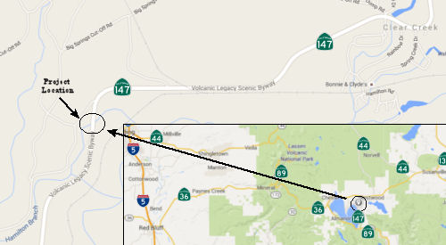 In October 2015, the CTC approved for future consideration
of funding a project that will replace the Hamilton Branch Bridge on Route 147 near the community of Clear Creek. The project is programmed in the
2014 State Highway Operation and Protection Program. The total estimated
cost is $13,492,000 for capital and support. Construction is estimated to
begin in Fiscal Year 2016/17. The scope, as described for the preferred
alternative, is consistent with the project scope programmed by the
Commission in the 2014 State Highway Operation and Protection Program. A
copy of the Negative Declaration has been provided to Commission staff.
The project will result in less than significant impacts to the
environment after mitigation.
In October 2015, the CTC approved for future consideration
of funding a project that will replace the Hamilton Branch Bridge on Route 147 near the community of Clear Creek. The project is programmed in the
2014 State Highway Operation and Protection Program. The total estimated
cost is $13,492,000 for capital and support. Construction is estimated to
begin in Fiscal Year 2016/17. The scope, as described for the preferred
alternative, is consistent with the project scope programmed by the
Commission in the 2014 State Highway Operation and Protection Program. A
copy of the Negative Declaration has been provided to Commission staff.
The project will result in less than significant impacts to the
environment after mitigation.
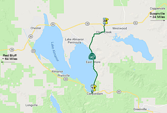
In January 2016, the CTC approved SHOPP funding in Plumas County, on Route 147 near Canyon Dam, from 0.1 mile south to 0.4 mile north of Hamilton Branch Bridge No. 09-0065. Outcome/Output: Replace bridge on same alignment. $6,610,000.
In June 2018, Caltrans District 2 tweeted that "The new
Hamilton Branch Bridge on SR 147 is almost complete." and that work was
being done to improve the connecting pavement.
(Source: @CaltransD2 6/5/2018)
 National Trails
![[Volcanic Byways]](logos/volcanic.jpg) This route is part of the Volcanic Legacy Scenic Byway All American Road.
This route is part of the Volcanic Legacy Scenic Byway All American Road.
 Other WWW Links
 Statistics
Overall statistics for Route 147:
 Pre-1964 Legislative Route
In 1933, Chapter 767 defined the route from "[LRN 2] near Arroyo Grande to [LRN 2] near San Luis Obispo" as part of the state highway system. In 1935, LRN 147 was added to the highway code with the definition. The route remained unchanged until 1963. It ran from US 101 near Arroyo Grande to US 101 near San Luis Obispo, and is present-day Route 227.
© 1996-2020 Daniel P. Faigin.
Maintained by: Daniel P. Faigin
<webmaster@cahighways.org>.
 From Route
  Route 146
 Route 148