
Former State Route 196
Click here for a key to the symbols used. An explanation of acronyms may be found at the bottom of the page.
 Routing
 No current routing.
 Post 1964 Signage History
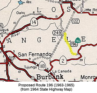
In 1963, Route 196 was defined as "Route 2 to Route 249 south of
Palmdale". This would have run roughly along Pacifico Mountain Road and
Horse
Flats Road, between Route 2 and Route 249 (approximately LA County Sign Route N3, Angeles
Forest Highway). See Route 249 for some further discussion.
In 1965, Chapter 1372 deleted this route.
 Pre 1964 Signage History
This segment was LRN 269, defined in 1959.
Route 196 was not defined as part of the initial state signage of routes
in
1934. It is unclear what (if any) route was signed as Route 196 between
1934
and 1964.
 Other WWW Links
 Pre-1964 Legislative Route
In 1933, Chapter 767 added the route from "[LRN 2] near Oceanside to [LRN 77] near Vista" to the highway system. In 1935, this route was added to
the
highway code as LRN 196, with the definition:
"[LRN 2] near Oceanside to [LRN 77] near Vista"
In 1947, Chapter 1233 changed the terminus to remove the reference to
[LRN 77]: "…to [LRN 77] near Vista"
In 1951, Chapter 1562 extended the route: "…to Vista
[LRN 77] near Escondido"
This route ran from US 101 (present-day I-5) near Oceanside to US 395
(present-day I-15) near Escondido. This is the portion of Route 78 between
I-5
and I-15.
Acronyms and Explanations:
- "LRN" refers to the Pre-1964 Legislative Route Number.
"US" refers to a US Shield signed route.
"I" refers to an Eisenhower Interstate signed route.
"Route" usually indicates a state shield signed route, but said route may be signed as US or I.
- Previous Federal Aid (pre-1992) categories:
Federal Aid Interstate (FAI); Federal Aid Primary (FAP);
Federal Aid Urban (FAU); and Federal Aid Secondary (FAS).
Current Functional Classifications (used for aid purposes):
Principal Arterial (PA); Minor Arterial (MA);
Collector (Col); Rural Minor Collector/Local Road (RMC/LR). Note that ISTEA repealed the previous Federal-Aid System, effective in 1992, and established the functional classification system for all public roads.
- Other frequently used terms: California Transportation Commission (Commission or CTC), California Department of Transportation (Department or Caltrans), Regional Improvement Program (RIP), Interregional Improvement Program (IIP), State Transportation Improvement Program (STIP), State Highway Operation and Protection Program (SHOPP), Traffic Congestion Relief Program (TCRP), Clean Air and Transportation Improvement Act of 1990 (Proposition 116), High Speed Passenger Train Bond Program (Proposition 1A), Highway Safety, Traffic Reduction, Air Quality, and Port Security Bond Act of 2006 (Proposition 1B), Corridor Mobility Improvement Account (CMIA), State Route 99 Bond Program (RTE or SR 99), Local Bridge Seismic Retrofit Account (LBSRA), Trade Corridors Improvement Fund (TCIF), Highway-Railroad Crossing Safety Account (HRCSA), State-Local Partnership Program (SLPP), Environmental Phase (PA&ED), Design Phase (PS&E), Right of Way (R/W), Fiscal Year (FY), Active Transportation Program (ATP), Trade Corridor Enhancement Program (TCEP), Local Partnership Program (LPP), Local Streets and Roads Program (LSRP), Solutions for Congested Corridors Program (SCCP).
 Route 195
 Route 197
© 1996-2020 Daniel P. Faigin.
Maintained by: Daniel P. Faigin
<webmaster@cahighways.org>.

 California Highways: