
 California Highways:
Click here for a key to the symbols used. An explanation of acronyms may be found at the bottom of the page.
 Routing
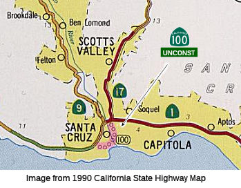 From the junction of Routes 1 and 17 to Route 1 west of the San Lorenzo River via
the beach area in Santa Cruz.
From the junction of Routes 1 and 17 to Route 1 west of the San Lorenzo River via
the beach area in Santa Cruz.
 Post 1964 Signage History
This routing is unchanged from its 1963 definition. It was a proposed freeway loop routing through Santa Cruz. This route adoption was rescinded in August 1975. The route location was never determined. There is no local traversable routing.
Back in the 1960's, Caltrans proposed creating a freeway bypass of Route 1 along the Mission Street corridor. The Santa Cruz City Council endorsed
a proposal which would have paralleled Mission Street to the north,
cutting through some neighborhoods along the entire route. The nearby
residents appealed this decision all the way to the California
Transportation Commission, which sided with the residents and chose their
alternative of an alignment on the northern outskirts of town through the
recently-opened University of California Santa Cruz (UCSC). This is what
is legislatively Route 100. However, UCSC strongly objected to this new
alignment, and eventually the entire bypass issue was dropped.
(Source: Santa Cruz Streets, h/t Aaroads)
 Pre 1964 Signage History
This was LRN 287, defined in 1959 by Chapter 1062 as “[LRN 5]
(Route 17) to [LRN 56] (Route 1) via Ocean Street, Second Street, and
Chestnut Street in Santa Cruz”. In 1961, Chapter 1146 reworded the
definition to be “The junction of [LRN 5] and [LRN 56]
via the beach area in Santa Cruz to [LRN 56] west of the San
Lorenzo River via Ocean Street, Second Street, and Chestnut
Street in Santa Cruz”. This was the definition that
became Route 100.
According to Scott Parker on AARoads, recalling friends whose families
were lifelong Santa Cruz residents, in the late '50's: the city was
pushing for a signed route that would expedite access to the beach from
both Route 1 and Route 17 after Route 1 was moved a bit inland onto its
current expressway/freeway alignment and away from downtown. As
Ocean Street, the original surface alignment of Route 17, was directly
served from both routes, it was considered the logical place to start the
loop. The Division of Highways commissioned LRN 287 but tried to
keep it as short as possible, not wanting to assume any more city street
maintenance than was absolutely necessary -- thus returning it to Route 1
at Chestnut street, where the then-new Route 1 expressway segued onto city
streets. Santa Cruz wanted the loop to "wiggle" all the way down to
the boardwalk, then return to Route 1 via Bay Street, a bit to the
west. After the number was changed to Route 100 after 1964, the DOH
proposed a simpler loop -- down Ocean, over Broadway, and back up Bay,
since they didn't want to deal with the streets along the boardwalk where
active SP tracks featured daily street-running freights to the Davenport
cement plant up the coast. The city and DOH could never reach a
final agreement, so the only active portion of Route 100 to exist were the
Ocean Street ramps from the Route 1/Route 17 interchange; back circa 1969,
while on a visit to the area, I actually saw a CA 100 milepost at the end
of the SB offramp (don't remember the precise mileage figure, but it
reflected the fact that the ramp was about a quarter-mile long). It
was definitely gone by the early 1990's.
(Source: Scott Parker (SParker) on AARoads, "Re: Unbuilt CA 100 in Santa Cruz", 4/20/2020)
Route 100 was not defined as part of the initial state signage of routes in 1934. It is unclear what (if any) route was signed as Route 100 between 1934 and 1964.
 Status
Unsigned and unconstructed.
According to the 2013 Traversable Highways report, the closest traversable routing is a network of city streets. Freeway route adoption was rescinded 8/20/75. No recommendation.
 Freeway
[SHC 253.1] Entire route. Added to the Freeway and Expressway system in 1959.
 Other WWW Links
 Statistics
Overall statistics for Route 100:
 Pre-1964 Legislative Route
In 1933, Chapter 767 added the route from "Rio Vista-Broderick Road on Ryer Island to Sacramento-Antioch Road" to the highway system. In 1935, this was added to the highway system as LRN 100, with the definition:
[LRN 99] on Ryer Island to that part of [LRN 11] between Sacramento and Antioch
This definition remained unchanged until the 1963 renumbering. It ran from present-day unsigned Route 84 on Ryer Island to present-day Route 160 (pre-1963 Route 24). This is present day Route 220.
© 1996-2020 Daniel P. Faigin.
Maintained by: Daniel P. Faigin
<webmaster@cahighways.org>.
 Route 99
 Route 101