
 California Highways:
Click here for a key to the symbols used. An explanation of acronyms may be found at the bottom of the page.
 Routing
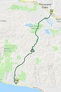 From Route 1 near Aliso Canyon to Route 101.
 Post 1964 Signage History
This segment was defined in 1963 to be from "Route 1 near Aliso Canyon to Route 101 near Triunfo." In 1981, Chapter 292 changed the wording to elminate the reference to Triunfo.
 Pre 1964 Signage History
In 1934, Route 23 was signed from Jct. Route 3 (US 101A, later Route 1) near Aliso Canyon to Fillmore. It corresponds to Decker Canyon Road (on the ocean side of Mulholland) and Westlake Road (on the vally side of Mulholland). It is very winding and very twisting, and portions are slow speed for good reason. However, other than Topanga Canyon (Route 27), it is the only Los Angeles county canyon road in the Malibu area that is state maintained (the other major roads: Kanan Dume and Malibu Canyon, are both County highways, not state highways). Route 23 was LRN 155, defined in 1933.
 Status
In March 2019, the CTC made the following emergency allocation:
$6,700,000 Los Angeles 07-LA-23 0.0/8.4. Route 23 In and near Malibu, from
Route 1 to 0.1 mile south of Country Ranch Road; also on Route 1 from
Route 23 to Deer Creek Road (PM LA-59.9/Ven-2.6). The Woolsey Fire began
on November 8, 2018. The fire has burned over 96,000 acres and destroyed
existing wood posts, signs, guardrail, support slopes, and fire debris are
collecting in the drainage systems. This project will clean fire debris,
repair drainage systems, guardrail, signs, and slopes.
(Source: March 2019 CTC Minutes, Agenda Item
2.5f.(1) Item 13)
Decker Rock Slide (07-LA-23 1.0/1.3)
In January 2023, the CTC received notice of the
following emergency G-11 allocation that occurred on 10/31/2022:
$3,100,000. 07-LA-23 1.0/1.3. PPNO 07-6000; ProjID 0723000041; EA 2XC30.
Route 23 Near Malibu, from 1.0 mile to 1.3 miles north of Route 1.
On October 11, 2022, a rock slide fell onto Route 23, resulting in a
closure of the highway. Maintenance crews removed the fallen rock,
and an assessment revealed the adjacent slope is unstable, with the
possibility of large boulders falling. This project is necessary to
perform rock scaling to remove loose boulders and other material, dispose
of that material, and construct a rockfall net to prevent other future
loosened material from falling onto the roadway. Allocation: CON ENG
$600,000 CONST $2,500,000. Additional $100,000 was allocated for right of
way purposes.
(Source: January 2023 CTC Agenda, Agenda Item 2.5f.(1) #9)
In January 2023, the CTC amended the following project
into the SHOPP: 07-LA-23 1.0/1.3. PPNO 07-6000; ProjID 0723000041; EA
2XC30. Route 23 Near Malibu, from 1.0 mile to 1.3 miles north of Route 1.
Perform rock scaling and construct rockfall net. Note: On October 11,
2022, a rock slide fell onto Route 23, resulting in a closure of the
highway. Maintenance crews removed the fallen rock, and an assessment
revealed the adjacent slope is unstable, with the possibility of large
boulders falling. This project is necessary to perform rock scaling to
remove loose boulders and other material, dispose of that material, and
construct a rockfall net to prevent other future loosened material from
falling onto the roadway. Allocation ($ × 1,000): PA&ED $0;
PS&E $0; R/W Sup $50; Con Sup $600; R/W Cap $100; Const Cap $2,500;
TOTAL $3,250. FY22-23.
(Source: January 2023 CTC Agenda, Agenda Item 2.1a.(1a) #5)
In November 2019, it was reported that Caltrans has completed a project
to improve the surface of the roadway on Westlake Boulevard between
Carlisle Road (VEN 0) and US 101 (VEN R3.283). Crews recently installed an
asphalt overlay on a winding, two-lane section of Westlake, also known as
Route 23, from Potrero Road south to Carlisle. Fixing the 1.9-mile stretch
of pavement was the final phase of a $5.5-million effort that started in
July. The lion’s share of the work was completed over the summer
when crews repaved the road between the freeway and Potrero Road. Work was
originally slated to be done at night, but the City of Thousand Oaks
requested that Caltrans perform work during the daytime to avoid sleep
disruptions for nearby residents. The schedule change increased the cost
of the project, and Caltrans announced in August that it was dropping the
final 2-mile stretch on the outskirts of the city due to budget
constraints. The announcement was met with displeasure from residents and
local officials. Days after Caltrans announced the truncated project, the
agency reversed course, saying it would be able to complete improvements
on the final stretch of road after all, but that the work wouldn’t
start for two months.
(Source: TO Acorn, 11/23/2019)
 Naming
 Decker Canyon was named for the Decker Family (in general) and Marion Decker (in
particular), one of the earliest settlers above Rancho Malibu, and a
leader of the settler movement aimed at opening public rights of way
across the Rancho. Decker Canyon was originally Los Alisos Canyon, and
much of the land N of Rancho Malibu in that area was owned by members of
the Decker family (James Decker, Martha Decker, Ernest Decker). At
one time, Decker Canyon was inhabited almost entirely by the Decker
family. The original family members were homesteaders—most likely a
mix of war veterans, tenant farmers and disgruntled Midwesterners looking
for a better life and a bit of free land. Under the 1862 Homestead Act,
they were entitled to as much as 160 acres. The Deckers have been in
Malibu since the 1860s, when Marion Decker staked his claim to 160 acres
of hilly land under the Homestead Act. Settling in the wild Malibu Hills,
the obstinate, pioneering Decker and other homesteaders ranched, farmed,
hunted, and cleared out a life for themselves it in the dusty canyons
above Malibu. The children attended the Decker Schoolhouse, where they
allegedly referred to one another as “cousin.” Like the
Scottish clans of old, the Deckers melded family and place until both had
just one name. No one in the family spoke of “Decker Canyon,”
or “Decker Road,” just “Decker.” There was an
almost intergenerational feud between the Decker family, as homesteaders,
and the wealthy Rindge family that controlled Rancho Topanga y Malibu. The
Rindges controlled the beaches and the one rutted dirt road that led to
Los Angeles. They repeatedly attempted to buy out the surrounding
homesteaders and even put up a gate to keep access to the road limited.
But the homesteaders, led by Marion, rebelled. The Deckers were the ones
who really were the instigators in terms of trying to open up Malibu by
any means necessary. Whether that meant bringing in people from the county
and then the state to try to advocate for the building of what is now
Route 1, whether that meant trying to sabotage May Rindge, or whether that
meant killing some of her livestock and attempting and making attempts on
her life. The Deckers really saw May Rindge as this enemy who was keeping
their chance of the promised land away from them. Until the day she died,
May believed that Marion was involved in burning down the couple’s
Malibu mansion in 1903. May eventually lost most of her Malibu estate in
1929 amid the stock market crash. To survive, she sold or leased land to
Hollywood types. However, as wealthy industry types began migrating to
Malibu in increasing numbers, property taxes went through the roof, and
the Deckers slowly moved away. The last remaining Decker in the canyon was
Millie Decker, whose husband, Jimmie Decker, who died in 1991, was the
last of the bloodline Deckers to live in the canyon. Millie Decker died in December 2018. Her property hit the market for 1.6 million in February 2024. The rustic cottage and
7.8 acres off Decker Canyon Road was purchased in 1936 by
Millie’s third husband, Jimmy Decker; it features a rustic,
light-filled two-bedroom, one-bathroom cottage with original knotty pine
paneling, Douglas fir wood flooring, a large redwood deck, and a stone
fireplace with rocks gathered from the surrounding hills. Keeping up the
cowboy theme, the property includes a glass green house, a refurbished
1950s travel trailer, and horse corrals.
Decker Canyon was named for the Decker Family (in general) and Marion Decker (in
particular), one of the earliest settlers above Rancho Malibu, and a
leader of the settler movement aimed at opening public rights of way
across the Rancho. Decker Canyon was originally Los Alisos Canyon, and
much of the land N of Rancho Malibu in that area was owned by members of
the Decker family (James Decker, Martha Decker, Ernest Decker). At
one time, Decker Canyon was inhabited almost entirely by the Decker
family. The original family members were homesteaders—most likely a
mix of war veterans, tenant farmers and disgruntled Midwesterners looking
for a better life and a bit of free land. Under the 1862 Homestead Act,
they were entitled to as much as 160 acres. The Deckers have been in
Malibu since the 1860s, when Marion Decker staked his claim to 160 acres
of hilly land under the Homestead Act. Settling in the wild Malibu Hills,
the obstinate, pioneering Decker and other homesteaders ranched, farmed,
hunted, and cleared out a life for themselves it in the dusty canyons
above Malibu. The children attended the Decker Schoolhouse, where they
allegedly referred to one another as “cousin.” Like the
Scottish clans of old, the Deckers melded family and place until both had
just one name. No one in the family spoke of “Decker Canyon,”
or “Decker Road,” just “Decker.” There was an
almost intergenerational feud between the Decker family, as homesteaders,
and the wealthy Rindge family that controlled Rancho Topanga y Malibu. The
Rindges controlled the beaches and the one rutted dirt road that led to
Los Angeles. They repeatedly attempted to buy out the surrounding
homesteaders and even put up a gate to keep access to the road limited.
But the homesteaders, led by Marion, rebelled. The Deckers were the ones
who really were the instigators in terms of trying to open up Malibu by
any means necessary. Whether that meant bringing in people from the county
and then the state to try to advocate for the building of what is now
Route 1, whether that meant trying to sabotage May Rindge, or whether that
meant killing some of her livestock and attempting and making attempts on
her life. The Deckers really saw May Rindge as this enemy who was keeping
their chance of the promised land away from them. Until the day she died,
May believed that Marion was involved in burning down the couple’s
Malibu mansion in 1903. May eventually lost most of her Malibu estate in
1929 amid the stock market crash. To survive, she sold or leased land to
Hollywood types. However, as wealthy industry types began migrating to
Malibu in increasing numbers, property taxes went through the roof, and
the Deckers slowly moved away. The last remaining Decker in the canyon was
Millie Decker, whose husband, Jimmie Decker, who died in 1991, was the
last of the bloodline Deckers to live in the canyon. Millie Decker died in December 2018. Her property hit the market for 1.6 million in February 2024. The rustic cottage and
7.8 acres off Decker Canyon Road was purchased in 1936 by
Millie’s third husband, Jimmy Decker; it features a rustic,
light-filled two-bedroom, one-bathroom cottage with original knotty pine
paneling, Douglas fir wood flooring, a large redwood deck, and a stone
fireplace with rocks gathered from the surrounding hills. Keeping up the
cowboy theme, the property includes a glass green house, a refurbished
1950s travel trailer, and horse corrals.
(Source: Historic Adamson House and Malibu Lagoon Museum Photo Archive; LA Weekly "The Last of the Malibu Hillbillies, 7/10/2003; Hollywood Reporter, 2/26/2024; Image source: Malibu Mille Decker FB Page)
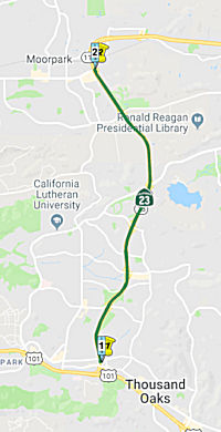 From Route 101 in Thousand Oaks to Route 118.
Post 1964 Signage HistoryThis segment was defined in 1963 as "Route 101 near Newbury Park to Route 118". This corresponded to the old surface routing. In 1984, Chapter 409 change the routing to better reflect the current Route 23 Freeway, by referring to "Route 101 in Thousand Oaks".
In 1964, a 13.1-mile section of Route 23 between three miles south of Tierra Rejada Road and the adopted route for the Route 126 Freeway near Fillmore was adopted by the Highway Commission. The three-mile segment south of Tierra Rejada Road superseded a section adopted in November 1962.
Pre 1964 Signage HistoryIn 1934, Route 23 was signed from Jct. Route 3 (US 101A, later Route 1) near Aliso Canyon to Fillmore. It was part of LRN 155.
The original routing of this segment was:
(Source: Gribblenation Blog - California State Route 23; Canyons, Surface Streets and Freeways)
StatusUS 101 / Route 23 Interchange (~ VEN R3.636)
In May 2009, using money from the ARRA (Stimulus Package), Ventura County commissioners agreed to give $6.5 million to Thousand Oaks to begin the design process for the widening of the interchange of US 101 and Route 23. The Thousand Oaks City Council recently decided to loan the project money from the city’s General Fund so the process could begin this year and to reimburse the General Fund when (if?) the state funding comes through in 2010-11. In late July 2009, the city reached a cooperative agreement with the California Department of Transportation to take over the design. The proposed improvements will add one lane on US 101 in each direction between the Los Angeles/Ventura County line and Moorpark Road by widening the freeway, restriping, reconstructing the median, and realigning a portion of the center line. Soundwalls will be constructed between Hampshire Road and Conejo School Road on the northbound side and between Manzanita Lane and Hampshire Road on the southbound side. The city hopes that the design process will be completed by May 2012 at the latest and that Caltrans will be able to take back the project at that point to begin the construction process. However, the construction phase is still unfunded at this point and additional federal funds will be required to complete the work by 2016 as laid out in the preliminary schedule.
In October 2012, it was reported that the Thousand Oaks City Council voted unanimously Oct. 9, 2012 to advance up to $17.7 million from its capital fund reserves to jump-start the estimated $42-million US 101/Route 23 interchange project, pending the granting of anticipated state and federal funds. Even with the council’s approval of the loan, work can’t begin until the state agrees to the arrangement. City and county officials have been trying unsuccessfully for years to obtain state and federal funds to pay for the interchange expansion, which would add a travel lane in each direction for drivers connecting to US 101 from Route 23 or vice versa. Thousand Oaks and VCTC tried twice before to obtain a $20-million federal Transportation Investment Generating Economic Recovery (TIGER) grant. Both applications were denied.
On March 1, 2013, the Ventura County Transportation
Commission, a body representing all 10 cities in the county, approved a
critical loan repayment agreement between the City of Thousand Oaks and
the state that could get the long-awaited construction effort underway by
the end of 2013. The project, which is estimated to cost $42 million,
would add a travel lane in each direction for drivers connecting to US 101
from Route 23 and vice versa. It’s been discussed for more than a
decade but the county has been unsuccessful up until now in finding the
funds to pay for it. Under the agreement, Thousand Oaks will put up $15.7
million to get the work started, money that would be repaid by 2016 from
the state’s Transportation Improvement Program. The Thousand Oaks
City Council voted unanimously in November 2012 to advance the money from
its capital fund reserves before millions in state funding becomes
available.
(Source: TO Acorn, 3/8/13)
In December 2013, it was reported that Caltrans planned to award the construction contract in January 2014. The roadwork will add a travel lane in each direction for drivers connecting to US 101 from Route 23 and vice versa. Sound walls will be constructed on the north side of the interchange between Hampshire and Conejo School roads and on the south side between Manzanita Lane and Hampshire. Caltrans plans to award the construction contract to Security Paving Co, Inc. of Sylmar, which submitted a $24.7-million bid in September.
In December 2015, it was reported that a decision to
redesign a sound wall along US 101 in Thousand Oaks could push back the
scheduled completion date of the US 101/Route 23 interchange expansion by
weeks, if not months. Started in February 2014, work to expand the
juncture of two of Ventura County’s busiest freeways was originally
expected to last around two years. Now it’s looking more like
two-and-a-half. The original plan was to save the existing retaining
walls; but once excavation began, that proved to be significantly
expensive because of the grading difference. The adjustments, approved by
the Thousand Oaks City Council, are waiting for the goahead from the
Ventura County Transportation Commission and CalTrans before they can take
place, an approval process that could take weeks or months. The sound wall
in question is on the south side of US 101 along southbound Hampshire
Road. The wall is being moved to provide the greatest possible reduction
in freeway noise to a nearby residential area on Willow Lane, according to
city report. This change saw the total cost of the expansion, now in its
21st month, swell from $33.6 million to $37.5 million, a difference of
nearly $4 million.
(Source: TO Acorn, 12/3/2015)
In February 2016, it was reported that the City
of Thousand Oaks was asking Caltrans to make good on its promise to plant
new trees in the place of those removed during the expansion of the US 101
- Route 23 interchange. The state agency had planned to hold off on the
proposed planting work until after drought conditions improve and the use
of potable water is no longer restricted for landscape purposes. Thousand
Oaks noted that the project Environmental Document identified the tree
removal as a biological impact that required mitigation through
installation of replacement trees based on the standards of the City of
Thousand Oaks Oak Tree Ordinance. Caltrans removed at least 16 mature oak
trees in accordance with project plans—and may have removed even
more. No timeline for when the replacement landscaping will be planted was
offered. As part of its 2015 Drought Action Plan, the state’s
transportation department has been evaluating all plantings that are
irrigated with potable water, including those that were promised as a
condition of project approval.
(Source: TO Acorn, 2/18/2016)
In April 2016, it was reported that construction
on the US 101/Route 23 freeway interchange in Thousand Oaks, originally
slated to finish in spring 2016, was now expected to end in August. The
Caltrans-led expansion of the county’s busiest interchange is in its
26th month. Work was delayed in late 2015 when engineers discovered a
soundwall intended for the south side of US 101 near Hampshire Road could
not be built as originally designed. The soundwall redesign increased the
anticipated cost of the expansion from $33.6 million to $37.5 million in
December, forcing the cash-strapped state agency to come up with an
additional $4 million. The taxpayers of Thousand Oaks are still waiting to
be paid back for the project by Caltrans and the Ventura County
Transportation Commission. So far, the city has somewhere between $11
million and $12 million invested, or roughly 37 percent of the total
expense.
(Source: Moorpark Acorn, 4/15/2016)
In June 2016, it was noted that the completion
date had been pushed to the fall. Ramp metering system installation and
drainage and irrigation work are nearing completion. About 50 percent of
remaining soundwall and retaining wall construction has been completed.
Over the next few months, construction activities will include profile
grinding, striping work and landscaping. In response to area
residents’ safety concerns, Caltrans has examined the Moorpark Road
northbound on-ramp and will be adding signage and a ramp meter, which will
help control the flow of traffic entering the freeway and also ease some
of the merging issues drivers are facing.
(Source: TO Acorn, 6/23/2016)
Lane Additions - US 101 to Los Angeles Avenue (~ VEN R3.636 to VEN R11.316)
There are plans to construct mixed-flow lanes in the median of this segment (March 2001 CTC Agenda).
Work began in early 2006 on a $58.3 million project
that will add one lane in each direction between Route 101 in Thousand
Oaks and Los Angeles Avenue in Moorpark. The project was originally slated
for funding in 2003 but became one of hundreds statewide to be put on hold
when transportation money was diverted to other uses to help balance the
state budget. As a result of that delay, an additional $14.1M for the
Ventura County project was required. As of March 2007, it was estimated
this widening project, now totalling $70M, will be completed in 2009.
However, it finished early, completing in April 2008. The route now has an
additional lane in each direction in the median, wider bridges, and new
sound walls expected to significantly reduce vehicle noise in adjacent
neighborhoods. Cables have been installed underneath the pavement to
provide real-time traffic data to the California Department of
Transportation. Traffic on Route 23, which connects the Ventura and Ronald
Reagan freeways, has grown from an average of 87,000 daily vehicle trips
in 1995 to more than 99,000 in 2008, according to Caltrans. The freeway's
expansion will help handle a projected 35% increase in traffic over the 25
years beginning in 2008. Construction was completed nearly 14 months ahead
of the scheduled opening in Fall 2009.
(Completion information source: Los Angeles Times)
NamingThe segment of this route between Route 101 and Route 118 is named the "Moorpark Freeway" (~ VEN R3.636 to VEN R11.316). The first segment opened in 1971; the last segment in 1994. It was named by location.
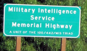 This segment has also been officially named the "Military Intelligence Service Memorial Highway" (~ VEN R3.636 to VEN
R11.316). This was in honor of the Nisei Soldiers of World War II who
served in units of the United States Armed Forces comprising the
100/442/MIS triad. Named by Assembly Concurrent Resolution No. 62, Chapter
115 in 1994. The other parts of the triad are two segments on Route 99.
This segment has also been officially named the "Military Intelligence Service Memorial Highway" (~ VEN R3.636 to VEN
R11.316). This was in honor of the Nisei Soldiers of World War II who
served in units of the United States Armed Forces comprising the
100/442/MIS triad. Named by Assembly Concurrent Resolution No. 62, Chapter
115 in 1994. The other parts of the triad are two segments on Route 99.
(Image source: Conejo Valley Guide)
 Freeway
[SHC 253.3] Entire portion. Added to the Freeway and Expressway System in 1959.
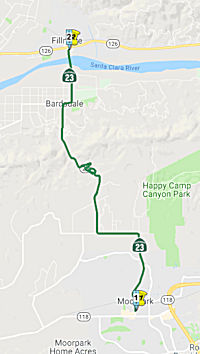 From Route 118 to Route 126 near Fillmore.
Post 1964 Signage HistoryThe routing for this is unchanged since 1963.
In 1964, a 13.1 mi segment of Route 23 between three miles south of Tierra Rejada Road and the adopted route for the Route 126 Freeway near Fillmore was adopted. The three-mile segment south of Tierra Rejada Road superseded a section adopted in November 1962. A 1965 planning map shows this as freeway; it was never upgraded. This freeway alignment is parallel to the existing traversable highway.
Pre 1964 Signage HistoryThis route has been signed as Route 23 since the initial state signage of routes in 1934. It was also part of LRN 155.
Freeway[SHC 253.3] Entire portion (not upgraded). Added to the Freeway and Expressway system in 1959.
 Classified Landcaped Freeway
The following segments are designated as Classified Landscaped Freeway:
| County | Route | Starting PM | Ending PM |
| Ventura | 23 | R3.47 | R3.90 |
| Ventura | 23 | R3.90 | R4.09 |
| Ventura | 23 | R4.20 | R6.49 |
| Ventura | 23 | R6.49 | R6.88 |
 Exit Information
 Other WWW Links
 Statistics
Overall statistics for Route 23:
 Pre-1964 Legislative Route
It is unclear, but the first reference related to a portion of what become LRN 23 may have been in 1901, when Chapter 111 declared part of the Sonora-Mono State Road as a state highway—in particular, the portion commencing east of Sonora, at a point known as Long Barn...and running thence across the summit of the Sierra Nevada Mountains to Bridgeport. This would cover what became LRN 23 between Sonora Jct and Bridgeport. More formally, the portion that become LRN 23 was added to the state system in the 1909 First Bond Issue, running from Saugus to Bridgeport. It was extended in 1911 when Chapter 468 established the “Alpine State Highway” as:
"The certain road commencing at the Calaveras big tree grove located in Calaveras County thence running to Dorrington in said county, thence E-ly following what is known as the Big Tree and Carson Valley Turnpike to Mt. Bullion in Alpine Cty, thence along county road to Markleeville in Alpine Cty, thence along that certain road via Kirkwood, Silver Lake, Pine Grove and Irishtown to Jackson in Amador Cty, including therewith the road from Picketts in Hope Valley connecting with the Lake Tahoe Wagon Road, a state highway, at Osgood's Place in El Dorado Cty, and the road from Mt Bullion via Loupe in Alpine Cty to Junction in Mono County connecting with the Sonora and Mono State Highway is hereby declared and established a state highway and shall be designated and known as "Alpine State Highway""
It was further extended in the Second Bond Act with a reference to "an extension connecting Antelope Valley in the County of Los Angeles with the city of Los Angeles by the most direct and practical route..."
By 1935, it was codified into the state highway code as the following route:
From Los Angeles to [LRN 11] near Osgood's Place in El Dorado County, via Saugus and Antelope Valley in Los Angeles County, Bridgeport in Mono County, Loupe, Mount Bullion, Markleeville and Pickett's (in Hope Valley) in Alpine County."
It was rapidly amended by 1935 Chapter 274 to be: “From Los Angeles to [LRN 11] near Meyers Station via Antelope Valley, Independence, Bridgeport, and Markleeville” The portion from Los Angeles to Markleeville was considered primary state highway.
In 1961, Chapter 1146 clarified the description, changing "Meyers Station" to "Meyers", making the definition “Los Angeles to LRN 11 near Meyers via the vicinity of Antelope Valley, Independence, Bridgeport and Markleeville.” This routing was signed as follows:
US 395, at this point, continued to the Nevada border as LRN 95. This is present US 395.
© 1996-2020 Daniel P. Faigin.
Maintained by: Daniel P. Faigin
<webmaster@cahighways.org>.
 Route 22
 Route 24