
 California Highways:
Click here for a key to the symbols used. An explanation of acronyms may be found at the bottom of the page.
 Routing
 Post 1964 Signage History
This segment remains as defined in 1963.
There were numerous delays regarding the transition of Route 76 from
conventional highway to an expressway or freeway between I-5 and I-15;
over this time, the existing route over Mission Aveneu could no longer
handle the capacity. The key bottleneck was the replacement of the Bonsall
Bridge. In 1983, a realignment project began for the westernmost 2.5 miles
of Route 76 in Oceanside. This was delayed for several years due to
environmental reasons. In 1988, the CTC approved a project to replace the
Bonsall Bridge during October 1988. The replacement of the Bonsall
Bridge broke ground during early 1989 and was opened to traffic during
1990.
(Source: Gribblenation Blog (Tom Fearer), “California State Route 76”, May 2022)
The realignment of the route finally started construction in 1994,
opening as an expressway in Oceanside between Interstate 5 and Foussat
Road in late 1995. It was named the San Luis Mission
Expressway. During June 1996, the second phase of the expressway
expansion between I-5 and I-15 began. Estimated completion was 2010, but
it wasn't until 2017 that Route 76 became a four-lane expressway between
I-5 and the eastern limits of Oceanside by May 2017.
(Source: Gribblenation Blog (Tom Fearer), “California State Route 76”, May 2022)
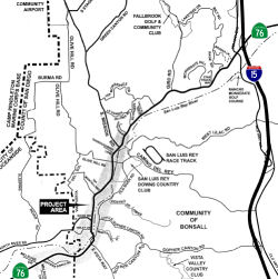
With respect to the portion of the route E of the Oceanside City Limits, it was adopted as a freeway but remained a conventional highway. During the second phase of construction, it was realized that the eastern portion of the freeway routing near I-15 would not be needed, and an effort was begun to rescind the freeway adoption. In the background to that recission near I-15 in 2016, it was noted that Route 76 was added to the State Highway System in 1933. The portion of Route 76 from I-5 (SD R0.0) to I-15 (SD R17.3) was adopted as a freeway on January 23, 1963. Following this adoption, Caltrans executed freeway agreements with the County of San Diego on June 25, 1964 and with the City of Oceanside on April 1, 1965. Subsequently, Caltrans decided that an expressway was the most feasible alternative to meet the long term transportation needs of the City of Oceanside. Route 76 was therefore denominated from a freeway to a controlled access highway from I-5 to the Oceanside eastern city limit and is covered by two controlled access highway Agreements executed between the City of Oceanside and the Department in 1993 and 1994. Route 76 between SD R9.0 and SD R17.3 remained adopted as a freeway until the recission proposal. When Route 76 was originally identified as a future freeway it was done in part to serve planned future growth in rural areas of eastern San Diego County. Since the late 1990’s the region has been moving away from new sprawling suburban developments and toward a smart growth (sustainable communities) model of development. That has resulted in a shift from new developments in the rural areas to infill projects in the urban coastal and non-coastal areas. This strategy is also consistent with the State’s greenhouse gas (GHG) strategies to reduce vehicle miles traveled. The conventional highway use of Route 76 was locally accepted and is in conformance with local and regional plans including the San Diego Associated Government’s (SANDAG’s) 2050 Regional Transportation Plan, the City of Oceanside’s General Plan Circulation Element, the Bonsall Community Plan Circulation Element Road Network, the Fallbrook Mobility Element Network and the County of San Diego General Plan Mobility Element. The County of San Diego supports the Department’s recommendation to downgrade Route 76 from a freeway to a conventional highway, on the condition that Route 76 continues to be retained as part of the State Highway System and continues to be maintained by the Department. In addition, the Department’s Transportation Concept Report (TCR) for Route 76, which includes an assessment of both current and future operating conditions, and improvements that will be needed to meet identified operational goals on the route, identifies the post 25-year Route 76 facility as a conventional highway.
 Pre 1964 Signage History
Signed Route 76 was not defined in the initial 1934 state signage of routes.
The current Route 76 was LRN 195, defined in 1933.
The route had its origins in a highway that followed the San Luis Rey
River east from Oceanside to Morettis Junction, which was showing up on
maps by 1917. In 1925 the concrete arch Bonsall Bridge was constructed
over the San Luis Rey River near Bonsall by San Diego County. The
1993 initial definition of LRN 195 was "LRN 2 (US 101) near Oceanside to
Descano-Temecula Road (LRN 78) near Lake Henshaw." From US 101/LRN 2 in
Oceanside, LRN 195 followed Mission Avenue and today's El Camino Real to
Mission San Luis Rey de Francia. From Mission San Luis Rey de
Francia, LRN 195 followed today's San Luis Rey Avenue, Mission Avenue and
grade now under the San Luis Rey Mission Expressway eastward to Bonsall
via the 1925 Bonsall Bridge. From Vista Way east to Bonsall, the
corridor of LRN 195 was part of LRN 77 and became part of US 395 when it
was extended to California during 1934. From Bonsall, LRN 195
followed a grade now under the San Luis Rey Mission Expressway to the
future location of I-15. Continuing E, the alignment of LRN 195
followed Pala Road to Pala. From Pala, LRN 195 followed Pala Road
eastward to LRN 78 at Morretis Junction near Henshaw Lake, providing
access to both ends of the road looping from Palomar Mountain. In 1934,
LRN 78 became Route 79.
(Source: Gribblenation Blog (Tom Fearer), “California State Route 76”, May 2022)
In 1950, US 395/LRN 77 was modernized and rerouted between San Diego and
Riverside to provide a direct north/south routing between San Diego and
Riverside by way of Escondido. The new alignment of US 395/LRN 77
removed it from LRN 195 in the vicinity of Bosnall. This left LRN 195 as a standalone routing through Bonsall. The 1952 Division Highways
Map was the first to feature LRN 195 signed as Route 76.
(Source: Gribblenation Blog (Tom Fearer), “California State Route 76”, May 2022)
Portions of this route (US 395 (now I-15) to Route 79) were signed as Route 76 starting in 1952. The entire route was signed as Route 76 by 1963.
Route 76/LRN 195 between US 101/I-5/LRN 2 in Oceanside east to US 395/I-15/LRN 77 was added to the Freeways & Expressways System in
1959. The connecting road from Route 76/LRN 195 to Palomar
Observatory was designated as part of San Diego County Sign Route S6 during 1959.
(Source: Gribblenation Blog (Tom Fearer), “California State Route 76”, May 2022)
 Status
In June 2019, the CTC authorized relinquishment of right of way in the
city of Oceanside (City) along Route 76 at Foussat Road (11-SD-76-PM 2.6),
consisting of a reconstructed city road. The City by letter dated March
14, 2019, agreed to waive the 90-day notice requirement and accept title
upon relinquishment by the State.
(Source: June 2019 CTC Minutes, Agenda Item 2.3c)
Melrose Drive (Oceanside) to I-15 Widening (~ SD R7.756 to ~ SD R17.158)
The SAFETEA-LU act, enacted in August 2005 as the reauthorization of TEA-21, provided the following expenditures on or near this route:
 There are plans to widen this route. The goal is to widen Route 76 from two to four lanes between
Melrose Drive in Oceanside (~ SD R7.756) and I-15 (~ SD R17.158). The goal
is to complete the 2½-mile stretch between Melrose and East Vista Way
in 2007. This length of time is due to bridge work and a number of
culverts that will be constructed for stormwater runoff and to serve as
wildlife corridors between the river and nearby upland areas. The widening
from East Vista Way to South Mission Road in Bonsall, which connects that
community with Fallbrook, won't begin before 2008, due to the length of
time it takes to determine the route and acquire property.
There are plans to widen this route. The goal is to widen Route 76 from two to four lanes between
Melrose Drive in Oceanside (~ SD R7.756) and I-15 (~ SD R17.158). The goal
is to complete the 2½-mile stretch between Melrose and East Vista Way
in 2007. This length of time is due to bridge work and a number of
culverts that will be constructed for stormwater runoff and to serve as
wildlife corridors between the river and nearby upland areas. The widening
from East Vista Way to South Mission Road in Bonsall, which connects that
community with Fallbrook, won't begin before 2008, due to the length of
time it takes to determine the route and acquire property.
According to observers, construction has started on Route 76 upgrade from a two lane road to an expressway between Melrose Drive in Oceanside (where the current expressway to I-5 ends) to South Mission Road in Bonsall. Pictures are available here.
In March 2009, the CTC approved for future
consideration of funding a project to widen Route 76 from two to four
lanes and construct roadway improvements from Melrose Drive and South
Mission Road near the community of Bonsall. The project includes local
Transnet and federal Demonstration funds. The total estimated cost is
$230,908,000, capital and support. The Department and San Diego
Association of Governments may consider pursuing federal stimulus dollars
in lieu of local or other federal funds. Construction is estimated to
begin in Fiscal Year 2009-10.
![[Bonsall]](maps/076-bonsall2.jpg) In January 2010, Caltrans broke ground on
a $182 million expansion that will add one lane in each direction, from
Melrose Drive in Oceanside to South Mission Road in Bonsall. About 30,000
vehicles travel the five-mile stretch daily — a figure that’s
expected to double by 2030 due to development. More than $75 million of
the project cost will be covered by the federal government’s
economic stimulus program, with an additional $17 million in federal
contributions and $14 million in state transportation funds. About $76
million will come from TransNet, a half-cent, voter-approved sales tax in
San Diego County. Completion is expected by the end of 2012.
In January 2010, Caltrans broke ground on
a $182 million expansion that will add one lane in each direction, from
Melrose Drive in Oceanside to South Mission Road in Bonsall. About 30,000
vehicles travel the five-mile stretch daily — a figure that’s
expected to double by 2030 due to development. More than $75 million of
the project cost will be covered by the federal government’s
economic stimulus program, with an additional $17 million in federal
contributions and $14 million in state transportation funds. About $76
million will come from TransNet, a half-cent, voter-approved sales tax in
San Diego County. Completion is expected by the end of 2012.
As for the stretch between between South Mission and I-15—that 5 1/2-mile stretch could possibly see work started by 2009, with completion in 2011. There are four alternatives being considered in the EIR:
There was originally a Split-Facility Alignment, which would build three westbound lanes along the existing alignment and three eastbound lanes on the proposed Southern Alignment, but that seems to have gone away. In Decmeber 2008, the CTC had no comments on the notice of preparation of the EIR for this project. The proposed project would construct roadway improvements consisting of lane additions and interchange ramp improvements along portions of Route 76 and Route 15 through the unincorporated communities of Bonsall and Fallbrook in San Diego County. Upon completion of the Environmental Impact Report (EIR), a proposed route adoption will be presented to the Commission. The project is fully funded and utilizes local tax ordinance, TransNet and TransNet Extension funding through the San Diego Association of Governments (SANDAG). Construction is expected to begin in Fiscal Year 2012.
 In April 2012, the CTC approved for future consideration of funding a project in San Diego
County that will widen and realign Route 76 from two to four lanes, from
South Mission Road in Bonsall to just east of the I-15 interchange,
including interchange improvements. The project is fully funded with
federal and local funds. The total estimated project cost is $201,000,000
for capital and support. Construction is estimated to begin in Fiscal Year
2012-13. Resources that may be impacted by the project include; land use,
growth, noise, biological, socio-economics, farmlands, cultural,
paleontological, and wetlands. Potential impacts associated with the
project that cannot be mitigated to below significance through proposed
mitigation measures include land use, community character and cohesion,
growth, and visual. As a result, a Final Environmental Impact Report
including a Statement of Overriding Considerations was prepared for the
project.
In April 2012, the CTC approved for future consideration of funding a project in San Diego
County that will widen and realign Route 76 from two to four lanes, from
South Mission Road in Bonsall to just east of the I-15 interchange,
including interchange improvements. The project is fully funded with
federal and local funds. The total estimated project cost is $201,000,000
for capital and support. Construction is estimated to begin in Fiscal Year
2012-13. Resources that may be impacted by the project include; land use,
growth, noise, biological, socio-economics, farmlands, cultural,
paleontological, and wetlands. Potential impacts associated with the
project that cannot be mitigated to below significance through proposed
mitigation measures include land use, community character and cohesion,
growth, and visual. As a result, a Final Environmental Impact Report
including a Statement of Overriding Considerations was prepared for the
project.
In December 2014, the CTC allocated $300K in Federal earmarked funds for the Route 76 East Roadway widening. This is a project in San Diego County near Bonsal and Fallbrook, on Route 15 from 0.3 mile South of to 0.3 mile North of Route 76/I-15 separation and on Route 76 from 0.4 mile West of South Mission Road to 0.5 mile East of Route 76/I-15 separation. The goal of the project is to construct a 4-lane highway by widening to 4-lanes, including curve realignment, installation of median barrier, and upgraded shoulder widths.
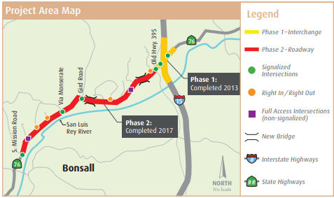 In January 2016, it was reported that more work has been
completed on Route 76 between Oceanside and I-15. The West Segment,
between I-5 and Melrose Drive, was completed in 1999. The Middle Segment,
between Melrose Drive and South Mission Road, was completed at the end of
2012. The East Segment is located between South Mission Road and I-15 and
is divided into two phases. East Segment Phase 1 construction on the Route 76/I-15 interchange began in October 2012 and was completed in summer
2013. East Segment Phase 2 construction to widen and realign the roadway
began in November 2014 and is anticipated to take about three years,
finishing in fall 2017. The intended facility, upon build-out, will be (at
minimum) a four-lane expressway with median barrier, bicycling
improvements, and environmental improvements associated with the highway's
proximity to the San Luis Rey River. Construction at this point continues
on through 2016 to improve what is a very busy corridor, especially for
traffic leading from Riverside County in the morning to Oceanside in the
morning and the reverse in the evening. There are no plans to modify Route 76 into a full freeway at this time. The segment of Route 76 east of I-15
is not slated for the same level of improvements to be seen on the portion
between I-5 and I-15.
In January 2016, it was reported that more work has been
completed on Route 76 between Oceanside and I-15. The West Segment,
between I-5 and Melrose Drive, was completed in 1999. The Middle Segment,
between Melrose Drive and South Mission Road, was completed at the end of
2012. The East Segment is located between South Mission Road and I-15 and
is divided into two phases. East Segment Phase 1 construction on the Route 76/I-15 interchange began in October 2012 and was completed in summer
2013. East Segment Phase 2 construction to widen and realign the roadway
began in November 2014 and is anticipated to take about three years,
finishing in fall 2017. The intended facility, upon build-out, will be (at
minimum) a four-lane expressway with median barrier, bicycling
improvements, and environmental improvements associated with the highway's
proximity to the San Luis Rey River. Construction at this point continues
on through 2016 to improve what is a very busy corridor, especially for
traffic leading from Riverside County in the morning to Oceanside in the
morning and the reverse in the evening. There are no plans to modify Route 76 into a full freeway at this time. The segment of Route 76 east of I-15
is not slated for the same level of improvements to be seen on the portion
between I-5 and I-15.
(Source: Andy3175 @ AAroads)
In July 2016, it was reported that the San Diego County
Board of Supervisors voted in June 2016 to approve the sale of 6.94 acres
of county-owned land and the granting of 2.98 acres of easements in
exchange for $143,599 in cash and three Caltrans remnant parcels valued at
$155,800. The Caltrans remnant parcels total 112,415 square feet, or 2.58
acres. This sale further enables the widening of Route 76 from two lanes
to four between South Mission Road and I-15. Because the future San Luis
Rey River Park will involve the acquisition of land only from willing
sellers, the exact boundaries have not yet been determined. Caltrans will
receive 6.09 acres of land which was acquired for potential river park use
and is currently managed by the county’s Department of Parks and
Recreation, but those portions are not necessary to the planned river
park. The other 0.85 acres to be acquired by Caltrans is managed by the
county’s Department of Public Works (DPW) but has no current or
planned future use by the county because it is on the south side of State
Route 76 and is separated from DPW’s road station by a road on the
north side of the state highway. Caltrans also required 0.81 acres of
permanent easement consisting of 0.67 acres of access easement and 0.14
acres of drainage easement along with 2.17 acres of temporary construction
easement.
(Source: Fallbrook and Bonsall Villiage News, 7/1/2016)
In May 2017, it was reported that motorists now can
drive from I-5 in Oceanside all the way to I-15 in Fallbrook along a
four-lane split highway with a lifesaving barrier in the middle. The
roughly $400 million state Route 76 improvement project has transformed
the highway from a once curvy two-lane road — clogged by rush-hour
traffic and occasionally scarred by head-on collisions — to a wider,
straighter thoroughfare. In mid-May 2017, state, federal and regional
transportation officials celebrated the completion of the last leg of the
project with a dedication ceremony just north of the highway at Pala Road.
Crews recently wrapped up the final five-mile stretch — from South
Mission Road in Fallbrook to I-15 — months ahead of schedule at a
cost of $201 million. That phase began in 2013 with the complete
reconfiguration of the I-15 interchange. All work that remains is
extensive landscaping of the highway using drought-tolerant plants. The
entire state Route 76 corridor project was divided into three segments:
west, middle and east. The western segment through Oceanside was completed
in 1999. The second phase, stretching from Melrose Drive to South Mission
Road, was finished in 2012 at a cost of $171 million. The project also
included the expansion of the Park & Ride at the intersection of the
highway and I-15. The parking lot has doubled in size and now features
charging stations for electric vehicles. Designed into the project were a
number of environmental features including bioswales, which are landscape
elements that remove pollution from surface runoff via a drainage course
with gently sloped sides that are filled with vegetation, compost or
riprap. Wildlife under crossings and directional fencing have been built
into the highway at various key points along the highway to allow wildlife
safe passage between areas of natural habitat. Throughout the project,
Caltrans has been working closely with the county, which has been buying
land and slowly developing a park along the banks of nearby San Luis Rey
River. The regional park one day will be 1,700 acres and 9 miles long,
beginning in Oceanside and ending near I-15, The dream is to offer active
and passive recreational opportunities along 20 miles of trails, while
preserving the river corridor. The reconfiguration of the highway required
the acquisition of adjoining parcels of land along the route, nearly 1,600
acres in all, before construction began. Some of the land will either
become part of the regional park or will buffer it.
(Source: San Diego U-T, 5/15/2017)
In June 2017, it was reported that Route 76 is now two
lanes in each direction between I-5 and I-15. A grand opening ceremony to
celebrate the completion of the final phase between South Mission Road and
I-15 was held May 16 near the intersection of the old alignment, which is
now an access road off the freeway, with Sage Road. Because the highway
was already open to traffic, the ribbon-cutting ceremony was replaced by
the planting of drought-tolerant shrubs which will be used to landscape
the area. In the November 1987 election, the county’s voters
approved the half-cent TransNet sales tax for transportation, and the
widening of Route 76 between I-5 and Melrose Drive in Oceanside utilized
TransNet revenue. In November 2004, the voters approved a 40-year
extension of the TransNet sales tax through 2048. The portion of the
widened Route 76 between I-5 and Melrose Drive in Oceanside was completed
in 1999. The widening between Melrose Drive and South Mission Road was
completed in 2012. Improvements on the interchange at Route 76 and I-15
opened to traffic in August 2013. The project widened Route 76 from 30
feet on average to 44 feet of paved surface which provided two travel
lanes, 12 feet wide, along with inside and outside shoulder lanes, 10 feet
wide. The road also includes turn lanes, acceleration and deceleration
lanes and barriers. Bicycle lanes are part of the widened road. The work
also includes improvements to the park-and-ride center on the northwest
corner of Route 76 and Old Highway 395. In addition to enlarging the
park-and-ride center, the improvements also include flattening the grade,
adding truck parking and a bus terminal, lighting and charging stations
for electric vehicles. Work began on cutting the slope in 2015 and
blasting to dissolve rock occurred during 2016. The paving, striping and
charging station are the remaining tasks for the park-and-ride
improvements, and the new park-and-ride center is expected to open to the
public in mid-June. The new Route 76 also includes bioswales and wildlife
undercrossings. A traffic signal was added at the intersection of Route 76
and Via Monserate, and all driveways and street intersections accessible
from Route 76 were renovated. The $201.7 million project between South
Mission Road and I-15 utilized $90.9 million of federal funding, $60.6
million of revenue from TransNet, $27.4 million of state Proposition 1B
funding and $23.0 million of developer and other local funding. The
portion between Melrose Drive and South Mission Road had a $151.8 million
cost, which was covered by $91.5 million of federal funding including
$76.6 million from the American Recovery and Reinvestment Act stimulus
program, $60.0 million of TransNet funding and $346,000 of local
contributions.
(Source: Valley News, 6/8/2017)
In October 2011, it was reported that Caltrans has
purchased the historical Rancho Lilac in Valley Center for $16.5 million
and plans to keep the 902-acre site undeveloped (accessible from SD
19.335). The purchase of the land, which includes Keys Creek, valleys and
rolling hills, was part of an agreement to mitigate environmental losses
from widening Route 76 between I-5 and I-15. The property includes a
cluster of buildings with a rich history. Just how those buildings will be
preserved and whether they will be open to the public has not been decided
as of the time of purchase. The $16.5 million purchase is the largest so
far made through Caltrans' Environmental Mitigation Program, which set
aside $850 million to preserve and restore habitat near major roads.
Mitigation efforts along Route 76 have included fencing and culverts that
have reduced the number of animals killed on the road. The new purchase
will provide a habitat for the endangered least Bell's vireo and coastal
California gnatcatcher. The endangered Stephen's kangaroo rat also has
been spotted on the property.
(Source: North County Times, 10/29/2011)
In December 2020, it was reported that the
San Diego Association of Governments will issue a new request for
proposals for the management of the Rancho Lilac land in Valley Center.
Although SANDAG staff recommended approval of the proposal from the San
Diego Habitat Conservancy, the SANDAG board voted 14-5 to seek a new
request for proposals. The representatives from Carlsbad, Escondido,
Imperial Beach, National City and San Diego voted against the motion. In
addition to the Rancho Lilac property, Caltrans acquired land by Highway
76 near North River Road, near Olive Hill Road, between Camino Del Rey and
South Mission and near Gird Road. The TransNet half-cent sales tax
includes an Environmental Mitigation Program to acquire, restore, and
manage property acquired for the mitigation of transportation impacts. The
acquisition of the Rancho Lilac property had several environmental
benefits: a buffer to maintain water quality in Keys Creek, habitat for
the Multiple Species Conservation Program in North County, providing
wildlife linkage, facilitating wildlife movement and permanently
preserving 46 cultural resources. Caltrans acquired the Rancho Lilac
property in 2011 using Environmental Mitigation Program funding. Caltrans
intended to transfer the property to a qualified land manager for
perpetual management after the highway work was completed. In 2016, SANDAG
solicited proposals for the management of Rancho Lilac. Three proposals
were received, and the proposal from the San Diego Habitat Conservancy had
the highest ranking during the evaluations. SANDAG and SDHC negotiated an
endowment amount of $6,994,129. The state required property improvements
such as lead abatement, hazardous materials cleanup, basic repair of some
historic buildings and weed abatement before the transfer. Concerns on the
management contract renewal focused on the lack of guaranteed trail
access. The county’s general plan has a trails element which
includes future north-south and east-west trails within the property.
Community meetings were held Oct. 15 and Oct. 20, and the two meetings
combined had more than 100 participants.
(Source: Village News, 12/3/2020)
In October 2018, it was reported that ENR had awarded
the California Best Projects 2018 Highway/Bridge award of merit to the
Route 76 East Segment. The 5.2-mile improvement project on Route 76
included widening a two-lane road to a divided four-lane highway and
updating bridges over the San Luis Rey River. The project team worked
around Native American protected sites in a sensitive river floodplain.
“The team was six months early in the delivery despite working in a
pretty highly environmental area,” a judge said. The project
restored 1,600 acres of habitat, and the team scheduled vegetation
clearing and pile-driving around habitat breeding seasons. The project
also built a bridge over culverts supplying water to the San Diego area.
To protect the culverts, girders for the new bridge were transferred in
mid-air using two cranes, each positioned at different bridge abutments.
Lead Design Firm/Structural/MEP. Engineer: Caltrans District 11. General
Contractor: Ames Construction. Civil Engineer: Dokken Engineering. Precast
Girders: Coreslab.
(Source: ENR, 10/2/2018)
In October 2015, the CTC authorized relinquishment of right of way in the city of Oceanside (11-SD-76-R7.7/R8.1), consisting of a nonmotorized transportation facility. The City, by controlled access highway agreement dated January 5, 1994, and by resolution dated August 20, 2014, agreed to waive the 90-day notice requirement and accept title upon relinquishment by the State.
In October 2014, the CTC authorized relinquishment of right of way in the city of Oceanside along Route 76 on Jeffries Ranch Road (~ SD 8.062 to SD 8.723), consisting of a reconstructed city street. The City, by controlled access highway agreement dated January 5, 1994 and by resolution dated August 20, 2014, agreed to waive the 90-day notice requirement and accept title upon relinquishment by the State.
Freeway Recisssion - E of Bonsall (~ SD R9.0 to SD R17.3)
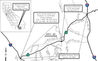 In March 2016, the CTC rescinded the freeway declaration
for Route 76 in the county of San Diego, Post Mile R9.0 to R17.3 in
accordance with the recommendation of the Chief Engineer. The background
to the resolution noted that Route 76 is currently designated as a freeway
from the easterly limits of the City of Oceanside to I-15, but operates as
a conventional highway. There are no local or regional planning studies
that contemplate Route 76 as anything but a conventional highway through
the portion currently designated as a freeway. The proposal was to rescind
the freeway declaration for Route 76, between the City of
Oceanside’s easterly limits and I-15, leaving this section as a
conventional highway. It was noted that no Right of Way acquisitions were
made in order to accommodate a freeway facility on Route 76, and that
rescinding the freeway declaration would allow the Department to
reconfigure the right of way needed in and around the I-15/Route 76
interchange as the right of way was reserved for a freeway to freeway
interchange. Once the Route 76 proposed rescission is approved, new right
of way lines would be established for a highway to freeway interchange and
excess lands can be disposed, reducing inventory, liability, and
maintenance efforts required.
In March 2016, the CTC rescinded the freeway declaration
for Route 76 in the county of San Diego, Post Mile R9.0 to R17.3 in
accordance with the recommendation of the Chief Engineer. The background
to the resolution noted that Route 76 is currently designated as a freeway
from the easterly limits of the City of Oceanside to I-15, but operates as
a conventional highway. There are no local or regional planning studies
that contemplate Route 76 as anything but a conventional highway through
the portion currently designated as a freeway. The proposal was to rescind
the freeway declaration for Route 76, between the City of
Oceanside’s easterly limits and I-15, leaving this section as a
conventional highway. It was noted that no Right of Way acquisitions were
made in order to accommodate a freeway facility on Route 76, and that
rescinding the freeway declaration would allow the Department to
reconfigure the right of way needed in and around the I-15/Route 76
interchange as the right of way was reserved for a freeway to freeway
interchange. Once the Route 76 proposed rescission is approved, new right
of way lines would be established for a highway to freeway interchange and
excess lands can be disposed, reducing inventory, liability, and
maintenance efforts required.
In October 2016, the CTC rescinded the freeway declaration for Route 76 in the County of San Diego, Post Mile (PM) R9.0 to R17.3 in accordance with the recommendation of the Chief Engineer. Route 76 was originally identified as a future freeway it was done in part to serve planned future growth in rural areas of eastern San Diego County. Since the late 1990’s the region has been moving away from new sprawling suburban developments and toward a smart growth (sustainable communities) model of development. That has resulted in a shift from new developments in the rural areas to infill projects in the urban coastal and non-coastal areas. This strategy is also consistent with the State’s greenhouse gas (GHG) strategies to reduce vehicle miles traveled. The conventional highway use of Route 76 is locally accepted and is in conformance with local and regional plans including the San Diego Associated Government’s (SANDAG’s) 2050 Regional Transportation Plan, the City of Oceanside’s General Plan Circulation Element, the Bonsall Community Plan Circulation Element Road Network, the Fallbrook Mobility Element Network and the County of San Diego General Plan Mobility Element. The County of San Diego supports the Department’s recommendation to downgrade Route 76 from a freeway to a conventional highway, on the condition that Route 76 continues to be retained as part of the State Highway System and continues to be maintained by the Department. In addition, the Department’s Transportation Concept Report (TCR) for Route 76, which includes an assessment of both current and future operating conditions, and improvements that will be needed to meet identified operational goals on the route, identifies the post 25-year Route 76 facility as a conventional highway.
In October 2014, the CTC authorized relinquishment of right of way in the county of San Diego along Route 76 between East Vista Way (~ SD R9.46) and South Mission Road (~ SD 12.438), consisting of superseded highway right of way and collateral facilities. The County, by letter dated August 1, 2014, agreed to waive the 90-day notice requirement and accept title upon relinquishment by the State.
Route 76/I-15 Interchange (SD R17.3)
In April 2012, the CTC authorized funding for the Route 76/I-15 Interchange Improvement. Near Bonsall and Fallbrook on Route 15 from 0.4 mile south to 0.8 mile north of Route 76/I-15 separation and on Route 76 from 0.5 mile west to 0.5 mile east of Route 76/I-15 separation. Modify interchange and widen bridge over I-5 to six lanes. This funding is contingent on the passage of the 2012 budget act.
Expansion East of I-15
There is also work to expand the route east of I-15. In April 2008, blasting commenced related to improvements to Route 76 east of I-15 to straighten and widen Route 76 to 4 lanes with a center turn lane for about 2 miles (~ SD R17.474 to SD R19.474). Later work will continue over to Valley Center Road that will make Route 76 two lanes with a center turn lane and full shoulders (to SD 32.841). The work is funded by impact fees assesed as part of expansions of 2 casinos, a quarry and a landfill to be built nearby.
A short, privately funded improvement is nearly complete on Route 76, for about 2 miles east of I-15 towards Pala. The new road is a striped 4 lane with left turn pockets where needed using modern geometry, there will be freeway style lighting at the intersections that have yet to be activated. Route 76 was a very narrow 2 lane road, that has had explosive traffic growth due to four major Indian casinos within 7 to 15 miles east of the interstate, three of which now have 10-15 floor hotel towers as part of the resorts. This project was totally funded by a soon to open quarry and the two casinos closest to the interstate, it eliminates some 90° bends that occur immediately east or the interstate. This project was a phase one, the next phase will extend the work to east of Couser Canyon road and will elimanate a sharp curve there by building the raod on a sweeping new alignment. Both phases were designed by Caltrans.
In April 2012, the CTC authorized vacation of right of way (prescriptive easement) in the county of San Diego along Route 76 between Pankey Road (~ 076 SD 17.866) and 0.8 mile easterly thereof. In September 2009, a portion of Route 76 was realigned by a private developer as part of the Palomar Aggregates Quarry. The quarry developer was required to improve this portion of the two lane conventional highway per developer agreement. As a result of that realignment a segment of the old road was superseded and is no longer needed for State highway purposes.
Valley Center Roundabout (~ 076 SD 32.869)
In July 2016, it was reported that the intersection of
Valley Center Road and Route 76 near Rincon will get be converted into a
roundabout in 2017. The total cost of the project will be $17.5 million,
which includes approximately $9 million in construction capital and $3.5
million in right-of-way capital. The goal of the project is to reduce the
number and severity of accidents at the intersection and realign the
curves just east of the intersection. Design of the preferred alternative
is tentatively scheduled for completion in 2016, with construction to be
done in 2017. Some locals are unsure if the accident rate at the
intersection justifies the roundabout, feeling that Caltrans is on a quest
to install roundabouts.
(Source: Valley Roadrunner, 6/30/2016)
In August 2016, it was reported that the CTC approved for future consideration of funding a project on Route 76 (11-SD-76, PM 32.6/33.3) in San Diego County that will construct a roundabout, curve realignment, and other improvements at and near the intersection of Route 76 and Valley Center Road (SD County Sign Route S4). The project is programmed in the 2014 State Highway Operation and Protection Program. The total programmed amount is $18,058,000 for capital and support. Construction is estimated to begin in Fiscal Year 2016-17. The scope, as described for the preferred alternative, is consistent with the project scope programmed by the Commission in the 2014 State Highway Operation and Protection Program.
In January 2018, it was reported that construction of a
roundabout at the intersection of Route 76 and Valley Center Road is on
schedule. Designed to curb serious accidents at the dangerous
intersection, the roundabout and associated road realignment are expected
to be completed by July 2018. The estimated $15.5 million project will
significantly slow traffic at the intersection, which for decades has been
controlled by a single stop sign at Valley Center Road. The intersection
is known as the "stage coach stop" and it has been the site of numerous
fatal and other accidents over the decades.
(Source: San Diego U-T, 1/17/2018)
 Naming
 The portion of Route 76 between the North Coast Highway and Douglas Drive in
the City of Oceanside (~ SD 0.00 to SD R3.762) is named the "Oceanside
Police Officer Tony Zeppetella Memorial Highway". It was named in
memory of Oceanside Police Officer Tony Zeppetella, who was shot and
killed in the line of duty on June 13, 2003, during the course of a
traffic stop. Tony Zeppetella was born on October 2, 1975, in Whittier,
California. He was raised in Paso Robles, California where he attended and
graduated from Paso Robles High School. Prior to beginning his career with
the Oceanside Police Department, Tony Zeppetella served in the United
States Navy for six years and attended Central Texas College and the
University of Phoenix. He joined the Oceanside Police Department on May
13, 2002. After successfully completing his academy training in October,
2002, he reported to the Oceanside Police Department, where he made
significant contributions to traffic safety and to the motoring public
while assigned to the Oceanside Police Department. Named by Assembly
Concurrent Resolution 133, August 11, 2004, Chapter 137.
The portion of Route 76 between the North Coast Highway and Douglas Drive in
the City of Oceanside (~ SD 0.00 to SD R3.762) is named the "Oceanside
Police Officer Tony Zeppetella Memorial Highway". It was named in
memory of Oceanside Police Officer Tony Zeppetella, who was shot and
killed in the line of duty on June 13, 2003, during the course of a
traffic stop. Tony Zeppetella was born on October 2, 1975, in Whittier,
California. He was raised in Paso Robles, California where he attended and
graduated from Paso Robles High School. Prior to beginning his career with
the Oceanside Police Department, Tony Zeppetella served in the United
States Navy for six years and attended Central Texas College and the
University of Phoenix. He joined the Oceanside Police Department on May
13, 2002. After successfully completing his academy training in October,
2002, he reported to the Oceanside Police Department, where he made
significant contributions to traffic safety and to the motoring public
while assigned to the Oceanside Police Department. Named by Assembly
Concurrent Resolution 133, August 11, 2004, Chapter 137.
(Image source: Find a Grave)
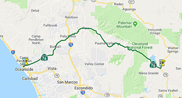
 The portion of Route 76 between Route 5 and Route 15 (~ SD R0.45 to SD R16.947) is
named the "San Luis Rey Mission Expressway".
Mission San Luis Rey, founded in 1798, was the 18th of 21
missions established in California. It is situated between the existing
missions at San Diego and San Juan Capistrano. Named by Assembly
Concurrent Resolution No. 6, Chapter 54, in 1995.
The portion of Route 76 between Route 5 and Route 15 (~ SD R0.45 to SD R16.947) is
named the "San Luis Rey Mission Expressway".
Mission San Luis Rey, founded in 1798, was the 18th of 21
missions established in California. It is situated between the existing
missions at San Diego and San Juan Capistrano. Named by Assembly
Concurrent Resolution No. 6, Chapter 54, in 1995.
(Image source: AAroads)
 The portion of Route 76 from SD
42.790 E to SD 47.790 at San Diego County Sign Route S7, East Grade Road, in the County
of San Diego, is named the "Joel Mendenhall Memorial Highway". It
was named after Joel Mendenhall, a real cowboy and cattle rancher, who as
part owner of Homegrown Cattle Company, Homegrown Meats, My Country Club
Hunting Ranch, and La Jolla Butcher Shop in La Jolla. Mendenhall was a man
who was quiet, but friendly, dependable, resourceful, devoted to his
family, and always ready to help someone who needed it. His family history
dates back to the first homesteaders of the Palomar Mountain area in the
mid-1800s. His work ethic was based on doing what was needed to get the
job done, never punching a clock, often working well into the night in all
kinds of weather, and demonstrating self-sufficiency and a willingness to
be there for others who needed help. Mendenhall always knew where the bass
were biting, the eagles were nesting, the turkeys were roosting, the big
bucks were in rut, or where a mountain lion might be prowling [hey, I
don't write these things -- this is all in the naming resolution - Ed.].
Mendenhall was comfortable on a good horse, skilled at roping and wielding
a branding iron, and enjoyed competition between himself and his dad for
big buck bragging rights. Mendenhall was always the first to help a young
lady bag her first deer, an old hunter drag out a downed buck, or offer
amazingly detailed instructions on where to set up for opening day of
turkey season. Joel Mendenhall died in a tragic ranching accident at a
Mesa Grande ranch while repairing a wheel loader when a part of the
vehicle known as a strong arm came down and pinned him between a wheel and
an axle on September 2, 2013, at 30 years of age, leaving behind a wife,
three young daughters, and his parents. Named by Assembly Concurrent
Resolution (ACR) 4, July 21, 2015, Resolution Chapter 113, Statutes of
2015. The signs were installed and dedicated in late August 2016, at a
naming ceremony attended by about 50 people including members of the
Mendenhall family whose roots in the Palomar Mountain area go back to the
mid-1800s.
The portion of Route 76 from SD
42.790 E to SD 47.790 at San Diego County Sign Route S7, East Grade Road, in the County
of San Diego, is named the "Joel Mendenhall Memorial Highway". It
was named after Joel Mendenhall, a real cowboy and cattle rancher, who as
part owner of Homegrown Cattle Company, Homegrown Meats, My Country Club
Hunting Ranch, and La Jolla Butcher Shop in La Jolla. Mendenhall was a man
who was quiet, but friendly, dependable, resourceful, devoted to his
family, and always ready to help someone who needed it. His family history
dates back to the first homesteaders of the Palomar Mountain area in the
mid-1800s. His work ethic was based on doing what was needed to get the
job done, never punching a clock, often working well into the night in all
kinds of weather, and demonstrating self-sufficiency and a willingness to
be there for others who needed help. Mendenhall always knew where the bass
were biting, the eagles were nesting, the turkeys were roosting, the big
bucks were in rut, or where a mountain lion might be prowling [hey, I
don't write these things -- this is all in the naming resolution - Ed.].
Mendenhall was comfortable on a good horse, skilled at roping and wielding
a branding iron, and enjoyed competition between himself and his dad for
big buck bragging rights. Mendenhall was always the first to help a young
lady bag her first deer, an old hunter drag out a downed buck, or offer
amazingly detailed instructions on where to set up for opening day of
turkey season. Joel Mendenhall died in a tragic ranching accident at a
Mesa Grande ranch while repairing a wheel loader when a part of the
vehicle known as a strong arm came down and pinned him between a wheel and
an axle on September 2, 2013, at 30 years of age, leaving behind a wife,
three young daughters, and his parents. Named by Assembly Concurrent
Resolution (ACR) 4, July 21, 2015, Resolution Chapter 113, Statutes of
2015. The signs were installed and dedicated in late August 2016, at a
naming ceremony attended by about 50 people including members of the
Mendenhall family whose roots in the Palomar Mountain area go back to the
mid-1800s.
(Additional Information and Images: San Diego UT, 9/6/2016)
 Business Routes
The former surface routing of Route 76 is a business routing. It has been relinquished or vacated by Caltrans. This could relate to the relinquishments on the February 2003 CTC agenda: Relinquishment of the segment at PM 37.5 in the City of Oceanside, and vacation of the segment PM 6.7/7.4 in the City of Oceanside.
 Other WWW Links
 Freeway
[SHC 253.4] From Route 5 near Oceanside to Route 15. Added to the Freeway and Expressway system in 1959.
 Interstate Submissions
In November 1957, the designation I-76 was proposed for what is now I-80, in order to not conflict with US 80. This was rejected by AASHTO.
 Scenic Route
[SHC 263.1] Entire route.
 Statistics
Overall statistics for Route 76:
 Pre-1964 Legislative Route
The route that would become LRN 76 was first defined in 1931 by Chapter 82 as the route from Bishop to California-Nevada State line (Montgomery Pass). Although at times signed as part of Route 168, it was primarily signed as US 66. In 1931 (per April 1931 CHPW) the project was a routing from the Owens Valley to an interstate connection with a Nevada State Highway, and was viewed an alternative to LRN 63 (later signed as Route 168). As of 1931, the segment was a county road. Evidently, pre-1931, there was a lot of discussion between California and Nevada which route -- LRN 76/US 6 or LRN 63/Route 168 should be the ultimate interstate connection. Neither state highway department felt that a large outlay on the Westgard Pass Route (Route 168) other than maintenance and minor improvement was warranted for the traffic served; the Montgomery Pass route was deemed superior. For California, the principle value of the US 6 routing was the interstate connection during the winter months, where it was the only practical route. The Route 168 signage, pre-US 6, may have been temporary pending completion of the corresponding portion of Route 168, or it may have been signed as an alternative Route 168.
In 1933, the route was extended with two segments: Fresno-Yosemite Road at Shaw Avenue to Huntington Lake, and [LRN 23] to Camp Sabrina. In 1935, the route was codified in the highway code as follows:
In 1959, Chapter 1841 changed segment (c) [3] to be “[LRN 125] near Fresno”.
In 1961, Chapter 1146 amended the definition, but didn't appear to make any changes.
The route was signed as follows:
This was/is present-day US 6. Before the signage as US 6, this segment was signed as part of Route 168.
This segment was signed as Route 168.
This segment was signed as Route 168.
© 1996-2020 Daniel P. Faigin.
Maintained by: Daniel P. Faigin
<webmaster@cahighways.org>.
 From Route
  Route 75
 Route 77