
 California Highways:
Click here for a key to the symbols used. An explanation of acronyms may be found at the bottom of the page.
 Routing
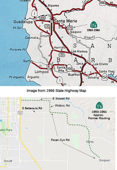 No current routing.
 Post 1964 Signage History
 In 1963, Route 176 was defined as the route from "Route 101 in
Santa Maria to Sisquoc."
In 1968, Chapter 282 relaxed the definition: "Route 101 in
near Santa Maria to Sisquoc."
In 1984, Chapter 1258 deleted Route 176.
Stowell Road, Philbric Rd, and Foxen Canyon Road are the former routings of this highway. Foxen Canyon Road continues S from Sisquc to Los Olivos and Route 154, but is a county route.
Some more information on this route was provided on AAroads: The US 101
Santa Maria bypass was completed about a year or so prior to the Great
Renumbering of '64; as such, the routings were changed while LRN's were
still "the law of the land", so to speak. At that time, Route 166 from
Route 1/LRN 56 at Guadalupe east to US 101 (Broadway) was part of LRN 148,
along Main St. When the bypass was completed around the east side of town,
LRN 148 was extended east to the bypass along Main St, signed as Route 166, which then turned north to multiplex with US 101/LRN 2 to a point
north of town, where it turned east on Route 166/LRN 57 toward Maricopa.
Prior to then, LRN 148 jogged on Broadway (old US 101, now Business Route 101/Route 135) south to Stowell Road, where it turned east. The segment from
Broadway to the bypass along Stowell was relinquished when LRN 148/Route 166 was moved to Main Street east to the new US 101 freeway. The segment
of Stowell Road east of the US 101 freeway, and the rest of former LRN 148
east to Sisquoc, became the new Route 176; it received signage in late
1968 (about the time that most formerly unsigned state-maintained highways
in Santa Barbara County, such as Route 135, Route 144, Route 217, Route 224, and Route 225 were signed in the field). The route was eventually
relinquished to the county circa 1984, with signage being removed within a
couple of years.
(Source: Scott Parker at AAroads, 4/7/2018)
 Pre 1964 Signage History
This route was LRN 148, defined in 1933. It appears not to have been signed before 1963.
Route 176 was not defined as part of the initial state signage of routes in 1934. It is unclear what (if any) route was signed as Route 176 between 1934 and 1964.
 Other WWW Links
 Pre-1964 Legislative Route
In 1933, the route from "Buena Park-Azuza Road near La Habra to [LRN 43] in Santa Ana Canyon via Brea" was added to the state highway system. In 1935, this route was added to the highway code as LRN 176 with the routing:
"[LRN 62] near La Habra to [LRN 43] in Santa Ana Canyon via Brea"
In 1959, Chapter 1062 changed the origin and relaxed the routing: "[LRN 62] near La Habra [LRN 174] near Norwalk to [LRN 43] in
Santa Ana Canyon via Brea"
This route ran from former Route 42 near Norwalk (before 1959, I-605) to
LRN 43 (US 91) in Santa Ana Canyon. This is the eastern portion of Route 90, which was formerly part of Route 42. The original routing,
pre-freeway, in Yorba Linda was a bit convoluted: Imperial Highway met
Yorba Linda Blvd, and continued E to Ohio Street, then down Ohio to
Mountain View, and across Mountain View to Orchard Dr. it then ran down
Orchard Dr to Orangethorpe, when it ran concurrent with LRN 175 (Route 14)
to LRN 43 (Route 18/US 91) at Imperial Highway. Orchard Drive has since
been renamed, and slightly rerouted, as Kellogg Drive.
(Source: Cahwyguy on AAroads, 11/18/2019)
It is now freeway near Yorba Linda.
© 1996-2020 Daniel P. Faigin.
Maintained by: Daniel P. Faigin
<webmaster@cahighways.org>.
 Route 175
 Route 177