
 California Highways:
Click here for a key to the symbols used. An explanation of acronyms may be found at the bottom of the page.
 Routing
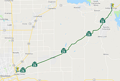 From Route 99 in Stockton to Route 12 at Valley Springs.
 Post 1964 Signage History
In 1963, this segment was defined as two segments: “(a) Route 4 to Route 99 near Stockton” and “(b) Route 99 near Stockton to Route 12”. In 1994, Chapter 1220 deleted segment (a), and changed this segment to be “Route 99 in Stockton to Route 12 at Valley Springs."
What happened in 1994 is that a portion of Charter Way west of Route 99 was designated as Route 26 (up to where Mariposa Road meets up with Charter Way). Charter Way west of that point is now signed as Business Route 99 and was US 99/Route 4, with Mariposa Road southwest to Farmington Road also a part of US 99/Route 4).
 Pre 1964 Signage History
This segment was signed as Route 8 before the 1964 renumbering, and was LRN 5, defined in 1933. Information on the original routing signed as Route 26 may be found below. Some additional history may be found in Tom Fearer's blog entry: California State Route 26.
 Status
Route 26/Route 99 Separation № 29-0142 (10-SJ-026 1.11)
The 2020 SHOPP, approved in May 2020, included the
following Bridge Preservation item of interest (carried over from the 2018
SHOPP): 10-San Joaquin-26 PM 1.1 PPNO 3169 Proj ID 1016000032 EA 1F170.
Route 26 near Stockton, at Route 26/Route 99 Separation No. 29-0142 (PM
1.11). Establish standard vertical clearance. Programmed in FY20-21, with
construction scheduled to start in July 2021. Total project cost is
$17,202K, with $11,543K being capital (const and right of way) and $5,659K
being support (engineering, environmental, etc.).
(Source: 2020 Approved SHOPP a/o May 2020)
In June 2021, the CTC approved the following
allocation: $11,735,000. 10-SJ-26 1.11. PPNO 10-3169; ProjID 1016000032;
EA 1F170. Route 26 Near Stockton, at Route 26/99 Separation No. 29-0142.
Outcome/Output: Establish standard vertical clearance by raising the
existing structure, reconstruct bridge approaches, widen shoulders, and
construct sidewalks. Allocation (includes savings and other sources): CON
ENG $3,221,000 CONST $11,536,000.
(Source: June 2021 CTC Agenda, Agenda Item 2.5b.(1)
#29)
In March 2022, it was reported that Caltrans was
preparing to begin a project that will improve vertical clearance for
freight vehicles by replacing the Route 26/Fremont Street Overcrossing of
Route 99 (~ 10-SJ-099 19.305 / 10-SJ-026 1.0) in Stockton.
Completion is expected in late 2022. This bridge replacement project
was awarded to AB Construction Inc. (Berkeley, CA), who will perform the
bridge replacement work required to provide the 16-feet, six-inch standard
vertical clearance in order to eliminate high-load bridge strikes.
The existing structure currently has low clearance and has experienced
damaged bridge girders due to several high-load strikes. The project will
also improve mobility and promote active transportation by installing new
sidewalks with overhead lighting on the new overcrossing. Beginning
in March 2022, motorist traffic over the Route 26/Fremont Street
Overcrossing will be reduced to one-lane in both the eastbound and
westbound directions while the old bridge is demolished, and the new
overcrossing is constructed. The bridge replacement will be done in
alternating phases, beginning with the north side of the bridge (westbound
direction.) Once this work is complete, work with shift to the south
side of the bridge (eastbound direction)
(Source: Caltrans District 10 on FB, 3/3/2022)
In January 2020, the CTC approved an allocation of $2,945,000 for
10-SJ-26 13.1/R13.8. On Route 26 Near Linden, from 0.3 mile east of Fine
Road to 0.1 mile west of Podesta Lane. Outcome/Output: Widen
travel lanes and shoulders to improve the existing conditions for Surface
Transportation Assistance Act (STAA) trucks.
(Source: January 2020 CTC Agenda, Agenda Item
2.5b.(1) #23)
In September 2011 and October 2011, the CTC approved vacation of right of way in the county of San Joaquin along Route 26 at 0.4 mile north of North Escalon Bellota Road (near 26 SJ R15.46), consisting of superseded highway right of way no longer needed for State highway purposes. The County of San Joaquin was given a 90-day notice of intent to vacate, without protesting such action.
 In April 2012, the CTC approved
for future consideration of funding a project in San Joaquin County near
the town of Linden that will realign two existing curves and replace the
Sandstone Creek Bridge (26 SJ 18.78) with a triple box culvert. The
project is programmed in the 2012 State Highway Operation and Protection
Program (SHOPP). The total estimated project cost is $6,049,000 for
capital and support. Construction is estimated to begin in Fiscal Year
2012-13. The scope, as described for the preferred alternative, is
consistent with the project scope programmed by the Commission in the 2012
SHOPP.
In April 2012, the CTC approved
for future consideration of funding a project in San Joaquin County near
the town of Linden that will realign two existing curves and replace the
Sandstone Creek Bridge (26 SJ 18.78) with a triple box culvert. The
project is programmed in the 2012 State Highway Operation and Protection
Program (SHOPP). The total estimated project cost is $6,049,000 for
capital and support. Construction is estimated to begin in Fiscal Year
2012-13. The scope, as described for the preferred alternative, is
consistent with the project scope programmed by the Commission in the 2012
SHOPP.
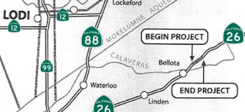
In June 2007, the CTC considered a project in San Joaquin and Calaveras Counties that would make roadway improvements near Linden from Wimer Road/Ospital Road (26 SJ 20.316) to Savage Way (26 CAL 3.068). This project is fully funded in the 2006 State Highway Operation and Protection Program (SHOPP). The total estimated project cost is $21,008,000. Construction is estimated to begin in FY 2008-09. The project will involve construction activities in the environmentally sensitive habitat of the California tiger salamander and the Western spadefoot toad. Three archaeological sites that are eligible for the National Register of Historic Places are located within the project area. In addition, farmland and relocation issues resulted in a Mitigated Negative Declaration being completed for this project.
In October 2021, the CTC authorized vacation of right-of-way in the
county of Calaveras along Route 26 from Burson Road to Penrod Road
(10-Cal-26-PM 2.6), consisting of superseded highway right-of-way no
longer needed for State highway purposes.
(Source: October 2021 CTC Agenda, Agenda Item 2.3d)
In December 2017, it was reported that Caltrans would be funding the
Valley Springs Complete Streets Capital Infrastructure Plan & Project
Prioritization. The Plan provides the community level planning needed to
develop conceptual complete streets transportation improvements that build
upon operational investments on Route 26 and the Route 12/Route 26
intersection (approx. 26 CAL 10.228), incorporates community aesthetic,
and provides safe travel options for residents and students to schools and
community centers. The project is a collaborative partnership of the
School, Caltrans, CHP, and Calaveras Council of Governments, Calaveras
County, and community.
(Source: My Mother Lode.Com, 12/9/2017)
 Freeway
[SHC 253.3] Entire portion (Stockton to Valley Springs). Added to the Freeway and Expressway system in 1965.
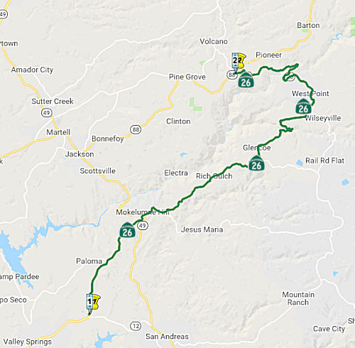 From Route 12 to Route 88 near
Pioneer Station via Mokelumne Hill and West Point.
From Route 12 to Route 88 near
Pioneer Station via Mokelumne Hill and West Point.
Post 1964 Signage HistoryIn 1963, this segment was first defined (by Chapter 385) as "Route 12 to Route 49 near Mokelumne Hill.". Before the year was out the routing was extended by Chapter 2155 to be "to West Point via Mokelumne Hill." In 1984, it was extended by Chapter 409 to terminate at "Route 88 near Pioneer Station via Mokelumne Hill and West Point" by a transfer of a segment from Route 104.
Pre 1964 Signage HistoryThis segment from Route 12 to West Point was originally signed as Route 8, and was part of LRN 5. This portion of LRN 5 was defined in 1963.
The remainder of this segment of Route 26 was originally Route 104. Route 104 was defined in 1970; the segment was transferred to Route 26 in 1986.
Some additional history may be found in Tom Fearer's blog entry: California State Route 26.
StatusRoute 49/Route 26 Interchange Improvements (10-Cal-26 PM 18.1)
 In October 2020, the CTC amended the following project into the 2020 SHOPP: 10-Cal-26 PM 18.1 PPNO
3494 ProjID 1019000164 EA 1K820. Route 26 near Mokelumne Hill, at the
intersection with Route 49. Intersection improvements. PA&ED:
$1,610K; PS&E: $1,759K; R/W Sup: $668K; Con Sup: $1,602K; R/W Cap:
$6,258K; Const Cap: $7,055; Total: $18,952K. Begin Const: 3/14/2025.
In October 2020, the CTC amended the following project into the 2020 SHOPP: 10-Cal-26 PM 18.1 PPNO
3494 ProjID 1019000164 EA 1K820. Route 26 near Mokelumne Hill, at the
intersection with Route 49. Intersection improvements. PA&ED:
$1,610K; PS&E: $1,759K; R/W Sup: $668K; Con Sup: $1,602K; R/W Cap:
$6,258K; Const Cap: $7,055; Total: $18,952K. Begin Const: 3/14/2025.
(Source: October 2020 CTC Agenda, Agenda Item
2.1a.(1a) #21)
In October 2020, the CTC approved the following SHOPP
Support Phase allocation: $1,610,000 for PA&ED for 10-Cal-26 PM 18.1.
PPNO 10-3494 ProjID 1019000164 EA 1K820. Route 26 Near Mokelumne Hill, at
the intersection with Route 49. Intersection improvements. (Concurrent
Amendment under SHOPP Amendment 20H-003; October 2020.)
(Source: October 2020 CTC Agenda, Agenda Item
2.5b.(2a) #34)
In September 2021, Caltrans started holding open houses
regarding a project to improve the intersection of Route 26 and Route 49
(~10-Cal-49 PM 27.565/27.66; 10-Cal-26 18.022/CAL 18.118), as a result of
a number of broadside collisions. The intersection where the two highways
meet currently has a four-way stop, which Caltrans believes warrants an
overhaul. Proposed alternatives to the current four-way stop include a
roundabout (Alternative 1) or two-signal stop lights (Alternative 2), with
the third option being to leave it as-is (Alternative 3). According to
Caltrans, a pattern of broadside collisions has been identified at the
intersection of Route 26 and Route 49, which are caused by motorists
failing to yield. The proposed roundabout is estimated to cost close to
$10.5 million dollars, while the traffic signal would cost about half of
that, at $4.8 million. Pros for the roundabout listed online by Caltrans
include eliminating head-on and broadside collisions, more continuous flow
of traffic, less noise and air pollution, and they are more
pedestrian-friendly. An obvious con is the cost, as well as more difficult
construction staging. Pros listed for a traffic signal include easier
construction staging, more cost-effectiveness, and ease of use as drivers
are already familiar with traffic signals at intersections. A major con
listed is higher through-speeds and more “conflict points”
leading to more severe collisions. Other cons listed are less continuous
flow of traffic, less pedestrian-friendly, and less access to businesses
near the intersection. In a Facebook poll posted in a Mokelumne Hill
community group, the majority of votes were for leaving the intersection
as-is, at 103 votes. The next highest response, at 32 votes, was in favor
of a roundabout, and only six votes went to the signal option. Several
community members submitted their own suggestions, including decreasing
the speed limits through the intersection, adding rumble strips, flashing
lights, or making stops required one way, with cross-traffic required to
yield. Two votes went to the proposal to “pay attention and
drive.” A tentative schedule provided by Caltrans estimates project
completion by November of 2025.
(Source: Caltrans District 10 on FB, 9/14/2021; Calaveras Enterprise, 10/20/2021)
In October 2022, the CTC approved for future
consideration of funding Highway 26/49 Intersection Control
Improvement Project (10-Cal-26, PM 18.10, 10-Cal-49, PM 18.10).
Improve safety at the intersection of Route 26 and Route 49, in Mokelumne
Hill, in Calaveras County. The project is located at the intersection of
Route 26 and Route 49, in Calaveras County. The Department proposes to
construct a roundabout at the intersection of Route 26 and Route 49 in the
town of Mokelumne Hill to reduce the number and severity of broadside
collisions at the intersection. This project is fully funded and currently
programmed in the 2022 SHOPP for a project total of $18,952,000, which
includes Right of Way (capital and support) and Construction (capital and
support). Construction is estimated to begin in 2024-25. The scope, as
described for the preferred alternative, is consistent with the project
scope as programmed by the Commission in the 2022 SHOPP.
(Source: October 2022 CTC Agenda, Agenda Item
2.2c.(1))
In October 2022, the CTC approved the following
pre-construction phase allocation: $2,427,000. 10-Cal-26 18.1. PPNO
10-3494; ProjID 1019000164; EA 1K820. Route 26 Near Mokelumne Hill, at the
intersection with Route 49. Intersection improvements. Allocation:
FY23-24 PS&E $1,759,000; R/W Sup $668,000. Concurrent consideration of
funding under Resolution E-22-84; October 2022.
(Source: October 2022 CTC Agenda, Agenda Item 2.5b.(2a) #12)
 Naming
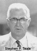 The segment between the community of Mokelumne Hill (approx 26 CAL 18.045) and West Point (approx 26 CAL 34.474) is named
the "Stephen P. Teale Highway". It was named in memory of State
Senator Stephen P. Teale, who was born in June 1916, in San Francisco and
moved to the community of West Point in Calaveras County in 1945, where he
lived until his death in 1997. Teale chose to become a physician and
surgeon in 1932, graduating from the California College of Osteopathic
Physicians and Surgeons in 1943, and he served two years of internship and
residency at Los Angeles County General Hospital. A few years after "Doc"
Teale settled in the foothills, he established his medical practice in
Calaveras County and quickly became a legendary figure, having won the
respect and loyalty of the citizens of Calaveras County and the Mother
Lode Country. In 1948, the people of Calaveras County elected him to the
county board of supervisors, where he served for five years, having been
re-elected in 1952. In a special election in 1953, "Doc" Teale was
overwhelmingly elected to the State Senate representing Calaveras,
Mariposa, and Tuolumne Counties, and, until his retirement in 1972, served
there with distinction, being recognized as one of the Legislature's most
influential and effective members. "Doc" Teale was also remarkable for his
continued interest in technology and, in recognition of his efforts to
establish computer technology in the Legislature, the Senate named the
state's computer center the "Stephen P. Teale Data Center". That name
lasted until 2005, when the Stephen P. Teale Data Center, Health and Human
Services Agency Data Center and the Department of General Services Office
of Network Services were consolidated to form a new agency: The Department
of Technology Services (DTS). As part of the new agency, Teale Data Center
became the Gold Camp Campus. Teale (as Chair of the Senate Reapportionment
Committee) and Don A. Allen Sr. (as Chair of the Assembly Elections and
Reapportionment Committee) were the two legislators responsible for the
1966 Senate reapportionment following the Reynolds v. Sims court decision.
Between 1974 and 1993, he served as a Member, California Post Secondary
Education Commission. Named by Senate Concurrant Resolution 43, Chapter
106, in 1997.
The segment between the community of Mokelumne Hill (approx 26 CAL 18.045) and West Point (approx 26 CAL 34.474) is named
the "Stephen P. Teale Highway". It was named in memory of State
Senator Stephen P. Teale, who was born in June 1916, in San Francisco and
moved to the community of West Point in Calaveras County in 1945, where he
lived until his death in 1997. Teale chose to become a physician and
surgeon in 1932, graduating from the California College of Osteopathic
Physicians and Surgeons in 1943, and he served two years of internship and
residency at Los Angeles County General Hospital. A few years after "Doc"
Teale settled in the foothills, he established his medical practice in
Calaveras County and quickly became a legendary figure, having won the
respect and loyalty of the citizens of Calaveras County and the Mother
Lode Country. In 1948, the people of Calaveras County elected him to the
county board of supervisors, where he served for five years, having been
re-elected in 1952. In a special election in 1953, "Doc" Teale was
overwhelmingly elected to the State Senate representing Calaveras,
Mariposa, and Tuolumne Counties, and, until his retirement in 1972, served
there with distinction, being recognized as one of the Legislature's most
influential and effective members. "Doc" Teale was also remarkable for his
continued interest in technology and, in recognition of his efforts to
establish computer technology in the Legislature, the Senate named the
state's computer center the "Stephen P. Teale Data Center". That name
lasted until 2005, when the Stephen P. Teale Data Center, Health and Human
Services Agency Data Center and the Department of General Services Office
of Network Services were consolidated to form a new agency: The Department
of Technology Services (DTS). As part of the new agency, Teale Data Center
became the Gold Camp Campus. Teale (as Chair of the Senate Reapportionment
Committee) and Don A. Allen Sr. (as Chair of the Assembly Elections and
Reapportionment Committee) were the two legislators responsible for the
1966 Senate reapportionment following the Reynolds v. Sims court decision.
Between 1974 and 1993, he served as a Member, California Post Secondary
Education Commission. Named by Senate Concurrant Resolution 43, Chapter
106, in 1997.
(Image source: Center for Sacramento History)
 Named Structures
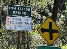 Bridge 30-0052 (26 CAL R033.65), crossing the Middle Fork of the Mokelumne River, near West Point, is named the "Tom Taylor Bridge".
Tom Taylor, a lifetime resident of Calaveras County, served as a County
Supervisor and was instrumental in securing funding for the construction
of the bridge that bears his name. A third generation resident of
Calaveras County, Taylor was born Nov. 25, 1919, to Maurice and Ruby Ames
Taylor in Rail Road Flat, where he lived most of his life. He was married
for more than 60 years to his childhood schoolmate Mary McPherson Taylor.
Taylor attended Rail Road Flat School and graduated from Calaveras High
School. He attended College of the Pacific before serving with the Naval
Construction Battalion (SeaBees) during World War II, when he was
stationed in Okinawa, Dutch Harbor, Alaska, and Port Hueneme, Calif. He
operated Taylor Logging Company and was a logging contractor throughout
the Mother Lode area and Lassen County until he retired in 1975. He also
was a land developer in Calaveras County. In 1980, Taylor was elected
county supervisor for District 2 n the position his uncle Tom Taylor had
held in the 1920s and was sworn into office on Jan. 5, 1981. He served 16
years on the board of supervisors, and retired in 1996. Several projects
were begun or completed during his time on the board, including the Rock
Creek Solid Waste Landfill near Milton, a new bridge for Route 26 over the
Middle Fork of the Mokelumne River near West Point and a new bridge on
Rail Road Flat Road over the South Fork of the Mokelumne. He was
instrumental in securing funding for construction of the new Middle Fork
bridge. He and his wife donated to the community the use of the property
which became known as Taylor Park in Rail Road Flat. He lived in Sonora
from 1962 to 1969, and at the time of his death, had lived in San Andreas
for five years. It was named by Assembly Concurrent Resolution 105,
Chapter 107 in 1998.
Bridge 30-0052 (26 CAL R033.65), crossing the Middle Fork of the Mokelumne River, near West Point, is named the "Tom Taylor Bridge".
Tom Taylor, a lifetime resident of Calaveras County, served as a County
Supervisor and was instrumental in securing funding for the construction
of the bridge that bears his name. A third generation resident of
Calaveras County, Taylor was born Nov. 25, 1919, to Maurice and Ruby Ames
Taylor in Rail Road Flat, where he lived most of his life. He was married
for more than 60 years to his childhood schoolmate Mary McPherson Taylor.
Taylor attended Rail Road Flat School and graduated from Calaveras High
School. He attended College of the Pacific before serving with the Naval
Construction Battalion (SeaBees) during World War II, when he was
stationed in Okinawa, Dutch Harbor, Alaska, and Port Hueneme, Calif. He
operated Taylor Logging Company and was a logging contractor throughout
the Mother Lode area and Lassen County until he retired in 1975. He also
was a land developer in Calaveras County. In 1980, Taylor was elected
county supervisor for District 2 n the position his uncle Tom Taylor had
held in the 1920s and was sworn into office on Jan. 5, 1981. He served 16
years on the board of supervisors, and retired in 1996. Several projects
were begun or completed during his time on the board, including the Rock
Creek Solid Waste Landfill near Milton, a new bridge for Route 26 over the
Middle Fork of the Mokelumne River near West Point and a new bridge on
Rail Road Flat Road over the South Fork of the Mokelumne. He was
instrumental in securing funding for construction of the new Middle Fork
bridge. He and his wife donated to the community the use of the property
which became known as Taylor Park in Rail Road Flat. He lived in Sonora
from 1962 to 1969, and at the time of his death, had lived in San Andreas
for five years. It was named by Assembly Concurrent Resolution 105,
Chapter 107 in 1998.
(Bio information: Calavas Enterprise obit; Image source: Bridgeof
the Week)
Pre 1964 Signage History1934-1938 Sign Route 26: Seal Beach to Santa Ana
 In 1934, Route 26 was
signed along the route from Route 3 (US 101A, later Route 1) near Seal
Beach to US 101 near Santa Ana along Bolsa Avenue and 1st Street. This was
LRN 183, defined in 1933, and deleted by 1951. The Route 26 signage
appears to have been dropped before the printing of the 1938 state highway
map.
In 1934, Route 26 was
signed along the route from Route 3 (US 101A, later Route 1) near Seal
Beach to US 101 near Santa Ana along Bolsa Avenue and 1st Street. This was
LRN 183, defined in 1933, and deleted by 1951. The Route 26 signage
appears to have been dropped before the printing of the 1938 state highway
map.
The demise of the original Route 26 came when US 6 was extended into
California on February 8, 1937. As US 6 was duplicating the number
the original Route 6 it would require the latter be renumbered.
Route 6 had been defined as being aligned on LRN 173 from Santa Monica to
Fullerton in the original run of Sign State Routes announced during August
1934. To accommodate US 6 the original Route 26 and Route 6 were
eliminated from their initial corridors. LRN 173 received the second
designation of Route 26, whereas LRN 183 was left without a Sign State
Route (although it remained a state highway). The original LRN 183
was eliminated from the State Highway System in 1951.
(Source: Gribblenation Blog (Tom Fearer), “The original California State Route 26 in Orange County”, April 2022)
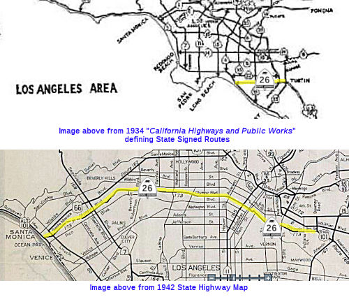
1938-1963 Sign Route 26: Santa Monica to Fullerton
In 1934, State Signed Route 6 was defined to run from Santa Monica to Jct. Route 39 near Fullerton. There were two portions: LRN 173, which ran from LRN 60 in Santa Monica to the intersection of Ninth and Indiana Streets in Los Angeles via Tenth Street; and LRN 166, which ran from LRN 172, at the intersection of Indiana and Third Streets, in Los Angeles, to LRN 171 near Santa Fe Springs. This routing corresponded to the post-1938 Route 26 (LRN 173 / LRN 166). Once US 6 was established, Sign Route 6 was renumbered as Sign Route 26, and then 1934 Sign Route 26 was dropped from the state highway system. This routing was along Pico Blvd E from signed Route 3 (Lincoln) [later signed US 101A (LRN 60), now Route 1], N on Robertson to Olympic, E on Olympic to Crenshaw, N on Crenshaw, E on 10th Street and 9th Street, then E on Mines Ave near Huntington Park, then SE along Anaheim-Telegraph Road to Santa Fe Springs, then SE along Los Nietos Road, S on Valley View, SE on La Mirada Road to Route 39.
By the time the 1938 state highway map was printed, LRN 173 (defined in
1933), the route originally signed as Sign Route 6 was resigned as Sign
Route 26. The original signed Route 6 ran from Santa Monica to Jct. Route 39 in Fullerton along roughly Olympic and Whittier. In Los Angeles, it ran
between US101A (Lincoln Blvd) and US101 along 10th Street, later renamed
Olympic Blvd (in 1939, the route ran along Pico between Lincoln and
Robertson). The route used the McClure Tunnel now used for I-10. Olympic
Boulevard was built (widened and realigned) in two stages. By 1938, major
improvements were completed. The jog at Figueroa Street was eliminated.
Near Alvarado Street, Hoover Street and Arlington Avenue, Olympic
Boulevard was realigned away from 10th Street to provide continuity.
Westerly of Lucerne Boulevard, Country Club Drive was renamed Olympic
Boulevard, widened throughout and extended through the 20th Century Fox
movie studio property. Further improvements were disrupted by World War
II. In 1948, the final links of Olympic Boulevard were constructed between
Crenshaw Boulevard and Lucerne Boulevard and between Centinela Avenue and
Lincoln Boulevard. The latter project was built as a landscaped divided
parkway with no driveways through the City of Santa Monica. Before the
construction of the freeway in downtown LA, the route continued along
Olympic Blvd and 9th St. to Atlantic Blvd (Route 15; LRN 167). A 1942 map shows that Route 26 was cosigned with Bypass US 101 from
approximately the Olympic/Telegraph junction to Route 19. A 1948 map shows
the route running along Olympic, 9th St, Anaheim, Telegraph, Los Nietos,
Whittier Road, La Mirada Road, and La Habra Road, terminating at the
intersection of Manchester Blvd (then Bypass US 101) and La Habra Road in
Buena Park. It was later replaced by I-10, the Santa Monica Freeway,
but early plans show this as the Olympic Freeway. The signage
for Route 26 may have been down by 1959.
(Some historical information on 10th St/Olympic
Blvd was derived from "Transportation Topics and Tales: Milestones in
Transportation History in Southern California" by John E. Fisher, P.E.
PTOE, available at http://ladot.lacity.org/pdf/PDF100.pdf)
Plans for sign gantries available on Michael Ballard's site show the intent was to have Route 26
signed at the East LA Interchange, leading into the Pomona and Santa Ana
Freeways. This was likely either due to the short routing of LRN 173 down
Whitter or along Olympic.
(Source: Michael Ballard, East LA Interchange, a/o 7/18/2020)
In 1937, Olympic Boulevard was announced as a component of Sign Route 26/LRN 173. The development of Olympic Boulevard began 1922 as a
local movement. Olympic Boulevard once complete would allow for a
direct alignment for Route 26/LRN 173 between US Route 101A in Santa
Monica east to LRN 166 east of downtown Los Angeles. LRN 173 was
added to the State Highway System following local level difficulties for
obtaining right-of-way for the Olympic Boulevard corridor, especially
through the Fox Film Company studios. During this time (i.e., around
1938), a temporary alignment via Pico Boulevard and Beverly Drive around
the incomplete segment of Olympic Boulevard was used. By 1940, the
majority of Olympic Boulevard west of downtown Los Angeles was complete;
despite a remaining gap on Olympic Boulevard in Santa Monica, Route 26/LRN 173 had been realigned off of Pico Boulevard. By 1941, two
additional segments of Route 26/LRN 173 on Olympic Boulevard had opened: a
span from Beverly Glen to Pontius Street, and a span from Pontius Street
to Bundy Drive. A two-mile segment of Olympic Boulevard from Bundy
Drive west to Lincoln Boulevard in Santa Monica was still incomplete. By
1942, Route 26 had a gap originating at the eastern terminus of LRN 173 at
Indiana Street in Los Angeles, and much of what had been Route 26 on
Anaheim-Telegraph Road (LRN 166) was designated as US 101 Bypass. An
eastern segment of Route 26 was still signed on LRN 171 east of Santa Fe
Springs on Valley View Avenue and La Mirada Road.
(Source: Gribblenation Blog (Tom Fearer), "California State Route 6 and the second California State Route 26", 3/2023)
1943 Legislative Chapter 964 changed the eastern terminus of LRN 173 to
"LRN 166 near Downey Road", which resolved the hanging end of the
highway. Route 26/LRN 173 was extended to US 101 Bypass/LRN 166 via
9th Street by 1944. There was still no connection between the eastern
segment of Route 26/LRN 171 to the western segment. By 1949, the final
segment of Olympic Boulevard opened between Bundy Drive and Lincoln
Boulevard. 1951 Legislative Chapter 1562 truncated the north
terminus of LRN 171 to LRN 62 near Buena Park; this led to the removal of
the eastern segment of Route 26.
(Source: Gribblenation Blog (Tom Fearer), "California State Route 6 and the second California State Route 26", 3/2023)
The California Highway Commission adopted 9.6 miles of the Olympic
Freeway on May 21, 1954. The adopted portion of the Olympic Freeway
was planned to span from the Santa Ana Freeway west to La Cienega
Boulevard as a new alignment of Route 26. In 1955, during the visit
with the California Highway Commission, the Los Angeles Chamber of
Commerce made a recommendation for the proposed Olympic Freeway as a new
limited-access corridor for LRN 173. The recommended corridor of the
Olympic Freeway was to begin at the Santa Ana Freeway and end 4.4-miles at
Hoover Street. In 1956, the corridor of the Olympic Freeway was
added as a chargeable corridor as a component of I-10.
(Source: Gribblenation Blog (Tom Fearer), "California State Route 6 and the second California State Route 26", 3/2023)
In June 1957, the groundbreaking ceremony commencing construction of the
Santa Monica Freeway at the Los Angeles River took place. By 1958, the
planned corridor of I-10 and the Santa Monica Freeway west of the Santa
Ana Freeway was being shown as part of LRN 173. In March 1962, the Santa
Monica Freeway and I-10 was opened to the Harbor Freeway. The newly
completed corridor of the Santa Monica Freeway completed an eastern bypass
loop of downtown Los Angeles, when paired with the Golden State
Freeway. By 1963, the completed segment of I-10 and the Santa Monica
Freeway east of the Harbor Freeway was showing on state highway maps, and
Sign Route 26 was truncated to existing solely on Olympic Boulevard west
of the Harbor Freeway.
(Source: Gribblenation Blog (Tom Fearer), "California State Route 6 and the second California State Route 26", 3/2023)
With the 1964 renumbering, Route 26 was reassigned to a segment of former
Sign Route 8 in the Sierra Nevada Mountains, and LRN 173 became a
component of I-10. The pre-1964 Sign Route 26 remained signed west of the
Harbor Freeway on Olympic Boulevard in interim as legislative spur of I-10
pending completion of the Santa Monica Freeway. By late 1964, I-10 and the
Santa Monica Freeway had been completed west to La Cienega Boulevard;
completion of I-10 west to Route 1 at Lincoln Boulevard was planned for
late 1965. Olympic Blvd was relinquished by 1967.
(Source: Gribblenation Blog (Tom Fearer), "California State Route 6 and the second California State Route 26", 3/2023)
 Other WWW Links
 Statistics
Overall statistics for Route 26:
 Pre-1964 Legislative Route
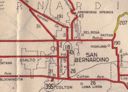 The route that was to become LRN 26 was first defined in the 1916 Second Bond Issue, together with LRN 27.
The wording was "an extension of the San Bernardino county state highway
lateral to the Arizona State Line near the town of Yuma, Arizona, via the
cities of Brawley and El Centro in Imperial County by the most direct and
practical route...". Given that the "San Bernardino county state highway
lateral" was LRN 9 (from LRN 4 (US 99) in San Fernando to San Bernardino,
this means that LRN 26 initially started near former US 66 in San
Bernardino. The 1944 map to the right shows the spur of LRN 26 into San
Bernardino along E Street. From there, the route continued to Colton, then
to Indio, down along the south shore of the Salton Sea to Heber and
Brawley, where it met LRN 27 in El Centro. LRN 27 (US 80, later I-8) then
continued easterly from El Centro to Yuma Arizona.
The route that was to become LRN 26 was first defined in the 1916 Second Bond Issue, together with LRN 27.
The wording was "an extension of the San Bernardino county state highway
lateral to the Arizona State Line near the town of Yuma, Arizona, via the
cities of Brawley and El Centro in Imperial County by the most direct and
practical route...". Given that the "San Bernardino county state highway
lateral" was LRN 9 (from LRN 4 (US 99) in San Fernando to San Bernardino,
this means that LRN 26 initially started near former US 66 in San
Bernardino. The 1944 map to the right shows the spur of LRN 26 into San
Bernardino along E Street. From there, the route continued to Colton, then
to Indio, down along the south shore of the Salton Sea to Heber and
Brawley, where it met LRN 27 in El Centro. LRN 27 (US 80, later I-8) then
continued easterly from El Centro to Yuma Arizona.
It was extended again on both ends in 1931. On the northwestern end, there was a significant extension west of Colton, adding a segment that ran from [LRN 26] near Colton via Pomona to Los Angeles. Specifically, segment (i) of Chapter 82 defined it as "[LRN 26] near Colton via Pomona to Los Angeles". The April 1931 CHPW also discussed the proposal for the route, which referred to it as "a highway from Los Angeles to a connection with [LRN 26] E of Colton". The confusing part here is that the extension did not start in Los Angeles; rather, it started from the eastern border of Los Angeles (roughly the LA River, just E of Eastern Avenue), near Ramona and Garvey. The routing utilized Garvey (much of which was later subsumed by I-10) and Holt Avenue. The rationale for the extension was to provide a mid-point route between LRN 9 (US 66) to the north, and the eventual US 60 routing to the south.
The 1931 act also extended the route on the southeastern end, extending it from El Centro and the junction with LRN 27 (US 80) to the border at Calexico. The extension's norther end was near the junction of LRN 12 (US 80 - El Centro to San Diego), LRN 27 (El Centro to Yuma), and LRN 26 (El Centro to Los Angeles) in the center of the intensely cultivated irrigation district of the Imperial Valley. The southern terminus was the only important entrance to California from Mexico E of the Pacific Coast.
In 1933, the route was extended from "Los Angeles (Aliso Street) to [LRN 26] near Monterey Park via Ramona Blvd", which completed LRN 26 into downtown Los Angeles. This was the eventual Ramona Expressway that became the San Bernardino Freeway (I-10).
By 1935, LRN 26 was codified into the highway code as:
It was primary state highway from San Bernardino to El Centro.
In 1959, Chapter 1841 deleted the connection from Colton to San Bernardino from the route (which ran along E street). Chapter 1062 earlier that year had added LRN 275, which was a routing from LRN 26 to LRN 190 (Route 30), so the connection was effectively transferred from LRN 26 to LRN 275.
In 1961, Chapter 1146 relaxed the description of segment (a) to eliminate
a specific routing (and thus permitting the Interstate routing): "Los
Angeles (Aliso Street) to Calexico via Ramona
Boulevard, Monterey Park, Pomona, Colton, Brawley, and El
Centro."
Signage along this route was as follows:
It then continued cosigned as US 99/US 70 through Colton and Redlands, rejoining with US 60 near Beaumont. LRN 26 continued E from Beaumont cosigned as US 60/US 70/US 99 until Indio.
The connection into San Bernardino from Colton, which was part of this route until 1959, was signed as Route 18.
From Indio, LRN 26 diverged from US 60/US 70, and continued S along the present-day Route 86 to Brawley, and then to El Centro. It continued through El Centro to cross US 80 (LRN 12) to Route 111 (LRN 201) near Heber. This was signed as US 99.
From Route 86 E of Heber to the border, it was signed as US 99, and later as CA 111.
© 1996-2020 Daniel P. Faigin.
Maintained by: Daniel P. Faigin
<webmaster@cahighways.org>.
 Route 25
 Route 27