
 California Highways:
Click here for a key to the symbols used. An explanation of acronyms may be found at the bottom of the page.
 Routing
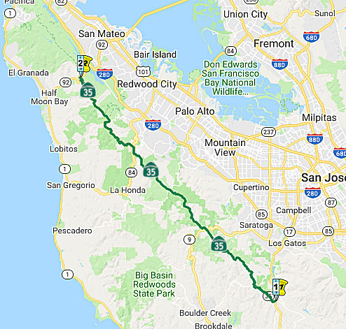 From Route 17 at Summit Road to
Route 92 via Skyline Boulevard.
From Route 17 at Summit Road to
Route 92 via Skyline Boulevard.
 Post 1964 Signage History
In 1963, this segment of Route 35 was defined as "Route 17 to Route 92 via Skyline Boulevard". In 1990, Chapter 1187 changed the origin to "Route 17 at Summit Road".
 Pre 1964 Signage History
This segment was LRN 55. It was originally signed as Route 5. It was defined in 1919.
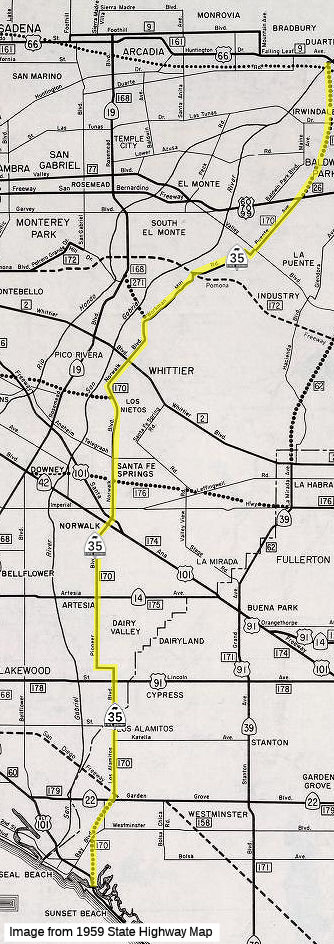
 In 1934, Route 35 was signed along the route from Jct. Route 22 near Seal
Beach to Jct. US 99 near West Covina via Santa Fe Springs. It ran from
US60/US70/US99 (LRN 26; now I-10) along Puente Ave, Workman Mill Blvd,
Norwalk Blvd, Pioneer Blvd, Norwalk Rd, and Los Alamitos Road to Route 22
(LRN 179) near Westminster. It was LRN 170, present-day I-605, defined in
1933, extended in 1957 and 1959.
In 1934, Route 35 was signed along the route from Jct. Route 22 near Seal
Beach to Jct. US 99 near West Covina via Santa Fe Springs. It ran from
US60/US70/US99 (LRN 26; now I-10) along Puente Ave, Workman Mill Blvd,
Norwalk Blvd, Pioneer Blvd, Norwalk Rd, and Los Alamitos Road to Route 22
(LRN 179) near Westminster. It was LRN 170, present-day I-605, defined in
1933, extended in 1957 and 1959.
 Naming
Portions of this route were named "Skyline Blvd" by Resolution Chapter 46 in 1919.
 Status
According to Scott Rux in 2004, between Route 17 to Route 9, there are regular reassurance markers and postmiles. There are several Caltrans callboxes, all of which list the name of the highway in their identification. At the intersection of Bear Creek Rd and Skyline Blvd, there are directional signs indicating the continuation of Route 35, with the usual green miner's spade designations. At Summit Rd south and Mountain Charlie Rd (about 0.1 mile north of Route 17), the highway is only signed as "To Route 17". There are no Route 35 shields at the interchange with Route 17.
Supposedly, some sections are one-lane wide, and appear to have been paved some time ago. A portion of Route 35 south of Route 9 is called the Goat Trail by CalTrans workers. Some portions of this route are maintained by the owners of the property near the road, and some portions are maintained by the County of Santa Clara or Santa Cruz County.
In fact, Route 35 (Skyline Blvd.) follows the north boundary of Santa
Cruz county (with both San Mateo and Santa Clara counties) for 20-30
miles, except that the boundary (defined by a mountain ridge) is so
irregular that the road can't exactly follow it. The road wanders in and
out of each county so frequently that most of the crossings are unmarked,
and even Caltrans' county based "postmiles" aren't very accurate. At one
point you're told that you're entering Santa Cruz county, and then about
0.4 mile later, you're told you're entering the city limits of Palo Alto.
(Palo Alto is in Santa Clara county, and cities can't extend across county
lines in California.) The southern portion of Route 35 between Route 9 and
Route 17 is also almost totally unmarked, apparently because local
residents tear down the signs.
(Based on a posting by John David Galt)
In February and March 2017, it was reported that major rains have caused
significant damage to the highway. Specifically, Route 35 has been closed
indefinitely after a portion of the roadway washed away W of Las Cumbres
Road, near PM 035-SCl-10.47, according to the California Highway Patrol. A
200-foot section of the roadway in that section slid downhill more than 50
feet and is completely gone. It almost looks like someone scooped out a
huge chunk of not only the road, but tons of earth that support the road
bed. A permanent rebuild of the highway and stabilization of the hillside
is estimated to cost more than $29.5 million. It has been reported that
the road was eventually repaired.
(Source: Mercury News, 2/11/2017; KCBS, 2/10/2017; Los Angeles Times, 4/3/2017)
Saratoga Safety Improvements
In October 2018, the CTC amended the following project
into the 2018 SHOPP: 04-SCl-35 14.1/17.1. PPNO 1462H. Project 0417000450.
EA 0P480. Route 35 Near Saratoga, from Route 9 Junction to San Mateo
County line. Install centerline rumble strips, curve signs, and high
visibility striping. Est. cost: $3,266,000. Begin const. 2/1/2022.
(Source: October 2018 CTC Agenda Item 2.1a.(1) Item
18)
The 2020 SHOPP, approved in May 2020, included the
following Collision Reduction item of interest (carried over from the 2018
SHOPP): 04-Santa Clara-35 PM 14.1/17.1 PPNO 1462H Proj ID 0419000296 EA
0P48U. Route 35 near Saratoga, from Route 9 Junction to San Mateo County
line; also in San Mateo County near Woodside from the Santa Clara County
line to Route 84 (PM 2.121/10.518). Install centerline rumble strips,
curve signs, pavement markings with audible traffic stripe systems,
optical speed bars, and high visibility striping. Programmed in FY21-22,
with construction scheduled to start in February 2022. Total project cost
is $6,383K, with $4,376K being capital (const and right of way) and
$2,007K being support (engineering, environmental, etc.).
(Source: 2020 Approved SHOPP a/o May 2020)
In May 2020, the CTC approved the following support
allocation: 04-SCL-35 14.1/17.1. PPNO 1462H ProjID 0419000296 EA 0P48U.
Route 35 Near Saratoga, from Route 9 Junction to San Mateo County line;
also in San Mateo County near Woodside from the Santa Clara County line to
Route 84 (PM 2.121/10.518). Install centerline rumble strips, curve signs,
pavement markings with audible traffic stripe systems, optical speed bars,
and high visibility striping. Allocation: PS&E $825,000; R/W Sup
$41,000.
(Source: May 2020 CTC Agenda, Agenda Item 2.5b.(2)
#7)
 Freeway
This segment was added to the freeway and expressway system in 1959, but was deleted in 1965.
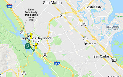 From Route 92 to Route 280 at Bunker Hill Drive.
Post 1964 Signage HistoryPart (2) was added in 1984 by Chapter 409.
Pre 1964 Signage HistoryBefore 1964, Route 35 was originally signed as Route 5. Before Route 280 was constructed, Route 5 began at the intersection of Route 9 (LRN 42) and Skyline, proceeded up to the junction of Route 92 (LRN 105), and then went over Crystal Springs Reservoir, and then turned north following the existing portion of Route 280 from the Route 92/I-280 interchange north to until where Skyline Blvd exits to the left. It was LRN 55. Route 5 was signed as part of the 1934 initial signage of routes. This was superseded in 1959 by LRN 237.
According to Chris Sampang, after I-280 was built through the area in the 1970s, the Skyline Boulevard state highway (Route 35) was rerouted to I-280 between Route 92 and the current Route 35 semi-directional Y in San Bruno. However, a few portions of the old Skyline Boulevard still remain:
Also, according to Chris, around when I-280 was built, a couple of portions of Skyline Boulevard were bypassed in the San Bruno area. One starts at the junction of Glenview Drive and Ridgeway Avenue and goes south for about 600 feet and is essentially a cul-de-sac. Some old dirt right-of-way is visible south of the cul-de-sac itself between the end of the segment and Cambridge Lane. At Cambridge Lane, another segment of Skyline Boulevard begins. This lasts for about 900 feet southbound and then feeds into a short residential street; some more dirt right-of-way is visible through what are some residential backyards and into the current Route 35/I-280 merge. In Daly City, there is a "Skyline Drive" which begins at Westline Drive (possible former Route 1) in Pacifica and continues north to near Thornton State Beach. Although the part that parallels the Route 1 freeway routing to Westline Drive is most likely a newer construction, the rest of Skyline Drive parallels the current Skyline Boulevard completely. The north dead end seems to be pointing in a straight line to the old Route 1 stub in Thornton State Beach; thus Skyline and Route 1 may have merged here previous to the construction of the current 4 lane expressway and John Daly/Skyline junction. For more information, see Route 1. As of October 2006, the old intersection with Route 1 is no longer fenced off. In 2005, Daly City reopened this portion as Thornton Beach Vista. It's a small parking lot with a short trail leading to the bluff, with a few informational signs along the trail. One sign shows the alignment of old Route 1 pre-1957, and the old pavement can clearly be seen across a small gully that was formed by the storms of 1982 (that part is fenced off). There is no access to the actual State Park; for that you still need to take the freeway portion of Route 1 to the Manor Drive exit and go north on the frontage road.
Naming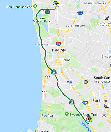 From Route 280 via Skyline Boulevard to Route 1 in San
Francisco.
From Route 280 via Skyline Boulevard to Route 1 in San
Francisco.
Post 1964 Signage HistoryIn 1963, this segment was defined as "Route 280 via Skyline Boulevard to Route 280 in San Francisco." In 1968, as part of the freeway reworking in San Francisco, the terminus was changed to "Route 1 in San Francisco", although this had no effect on the actual route, other than dropping a cosigning.
Pre 1964 Signage HistoryThis segment was signed as Route 5 between the initial signage of routes in 1934 and 1964. It was LRN 55, and was defined in 1919. See below for the original routing of signed Route 35.
The portion between the Route 1 Freeway and John Daly Drive was cosigned with Route 1 between 1957 and 1967.
StatusFreeway currently exists from 1 mile south of jct with Route 1, to 1 mile north of jct of Route 1.
In December 2017, the Caltrans Mile Marker noted that on Sloat Boulevard (Route 35 in San Francisco) they funded more of the Complete Streets Project: Caltrans in 2017 added more beacons and curb extensions, and extended bike lanes at this multi-phased project. Caltrans put a portion of Sloat Boulevard on a “road diet,” starting in 2012, shrinking the number of lanes from three to two, and adding bike lanes and improving crosswalks. In 2013, the city installed new crosswalk beacons at Forest View Drive.
Upper Great Highway
Although Great Highway, which connects to the northern
end of Route 35 in Lake Merced Park, is not part of Route 35, it is of
interest. In September 2020, it was reported that when the pandemic shut
down most of San Francisco, much of the 3.5-mile Great Highway closed to
car traffic. This has transformed the highway into a destination. When it
first opened on June 9, 1929, the Great Highway was intended to signal
man’s power over the elements, specifically, the sand and the tides.
The project cost more than $1 million to build, transforming what was
previously a two-lane roadway into what the Municipal Employee called
“one of the most magnificent municipal projects in the United
States.” The two men behind the Great Highway were city engineer
M.M. O'Shaughnessy, who gave us the Muni streetcar system and the Hetch
Hetchy Reservoir, and park Superintendent John McLaren, who gave us Golden
Gate Park. Erosion, aided by climate change, is forcing city and transit
planners to reconsider what the Great Highway will look like in coming
years. Because of erosion, the southern stretch from Sloat to Skyline will
include a “managed retreat” from the shoreline, and eliminate
the roadway entirely and reroute it. Instead, that area will become a
multi-use trail, which is what the currently car-free section of the Great
Highway is now.
(Source: SF Gate, 9/28/2020)
In August 2021, it was reported that the Upper Great
Highway reopened to vehicles on 8/16/2021, after becoming the second most
visited open space in San Francisco during the pandemic. As of that date,
the beachside promenade will allow vehicles on weekdays. It will remain a
car-free destination only during the weekend, from noon Fridays to 6 a.m.
Mondays, as well as holidays. The future of the road has been a source of
contentious debate on The City’s western border since it was closed
in April 2020 as part of San Francisco’s emergency pandemic
response. Supporters of the car-free street point to the thousands of
daily cyclists and pedestrians as proof of its success, while critics of
the temporary closure say it has resulted in worse traffic and travel
times. Supervisor Gordon Mar, who represents the Sunset, called it a
“meaningful compromise” and a “good road forward,”
though he’s under no illusions that it will be a panacea for
supporters or critics of the closure. Officials are quick to point out
that this is not a permanent plan for the Great Highway. They bill it as a
simple adjustment to pandemic-era modifications designed to respond to the
reopening of in-person instruction in schools as well as the continued
reopening of the economy. As is the case with all other pandemic-era
street changes, this temporary modification would remain in place until
120 days after the expiration of the mayor’s public health emergency
declaration. However, there are plans to craft a proposal for a pilot
program that would extend a version of the Great Highway closure —
either in this new configuration or another alternative — for one or
two years. City officials are adamant that public feedback will be a key
part of the proposal process. It will be up to the Board of Supervisors to
vote on this proposal and help to determine the future of the Great
Highway, but a timeline has not been announced.
(Source: SF Examiner, 8/5/2021)
In February 2022, it was reported that a San Francisco
Superior Court judge ruled that San Francisco acted lawfully when it
closed down three major roadways on the west side for pedestrians and
bicyclists during the COVID-19 pandemic. The closures of the Great
Highway, John F. Kennedy Drive and Martin Luther King Drive began at the
start of the pandemic and aimed to encourage walking and bicycling by
creating a network of car-free streets throughout amidst a stay-at-home
order. In December 2021, a resident along with the group Open the Great
Highway Alliance filed a lawsuit against the Recreation and Park
Department, the Recreation and Park Commission and Recreation and Park
General Manager Philip Ginsburg alleging the trio are violating local and
state laws by shutting down the roads to vehicles. The lawsuit sought a
preliminary injunction to force San Francisco to reopen the roads. In
February , a judge ruled in favor of San Francisco, affirming it was
authorized by law to temporarily close down the streets during a public
emergency. According to city officials, the Board of Supervisors is
anticipated to consider the permanent status of the car-free streets in
the near future.
(Source: SF Examiner, 2/14/2022)
In July 2022, it was reported that San Francisco
Supervisor Gordon Mar introduced legislation that would preserve the Great
Highway's current weekend configuration under a three-year pilot study,
while the city studies its road use. If approved by the San Francisco
Board of Supervisors, the ordinance introduced by Mar would maintain the
highway as a promenade until Dec. 31, 2025. Mar's plans for the Great
Highway are an example of adaptive developments being made in land use to
respond to the pandemic and climate change while opening up more
recreation area for residents. In April 2020, the city temporarily closed
the Great Highway to cars as an effort to prioritize safe, outdoor
recreation during the start of the COVID-19 pandemic. Then in August 2021,
an agreement between Mar and Mayor London Breed was reached to modify the
highway's closure to apply between Fridays at noon to Mondays at 6 a.m.,
and on holidays as well. When serving the public as a promenade, the Great
Highway is an enhanced outdoor space that offers safe access to the
beachfront for families, people with mobility assistance, joggers,
skateboarders, and more. From April 2020 to May 2022, the scenic
recreational hub has seen more than 2 million visitors. During the
three-year pilot period, if approved, the San Francisco Municipal
Transportation Agency and the San Francisco Recreation and Park Department
would continue to monitor visitor usage data, traffic conditions, and
public feedback. Collecting this information will help form a
recommendation for the highway's long-term future as San Francisco makes
adaptation plans in response to climate change. As sea level rise becomes
a growing concern of the changing climate's effects on San Francisco, the
city is already arranging plans, according to the Ocean Beach Climate
Change Adaptation Project; including the permanent closure of the Great
Highway extension south of Sloat Avenue, due to significant erosion
impacts. The project will close this section of the Great Highway to cars
indefinitely, and replace it with proposed improvements such as a new
multi-use trail.
(Source: CBS News Bay Area, 7/28/2022)
NamingPortions of this route were named "Skyline Blvd" by Resolution Chapter 46 in 1919.
 The portion of Route 35
that runs through the City of Daly City in the County of San Mateo from PM
SM 27.09 to PM SM 31.061 is named the "Alice Peña Bulos Memorial
Highway". It was named in memory of Alice Peña Bulos, who
served four decades empowering minorities and underrepresented groups of
all ages from every background within her own community and throughout the
world. Alice Peña Bulos opened her South San Francisco home to anyone
seeking counsel and assisted community members in gaining knowledge about
political empowerment, domestic violence, health care, and the United
States residency application process, to name a few. Alice Peña Bulos
received both her bachelors degree and masters degree in social and
behavioral sciences from the University of Santo Tomas in the City of
Manila, Philippines, and became a Professor of Sociology and later
chairperson of the Department of Sociology at the University of Santo
Tomas before moving to Sacramento, California, in 1977 to pursue a career
as an employment counselor at the California Educational Theatre
Association (CETA). Alice Peña Bulos was inducted into the County of
San Mateo’s Women’s Hall of Fame in 1988 and served on the
County of San Mateo’s Commission on the Status of Women. Alice
Peña Bulos was appointed to the National Council on Aging by former
President William Jefferson Clinton in 1993, acting as delegate to the
White House Conference on Aging until 2000. Alice Peña Bulos was the
Chair of CORA Kumares, a nonprofit, nonpolitical, nonpartisan team of
volunteers formed in 2003 to engage individuals and groups to share
resources toward educating the public about healthy relationships; in
2009, the team renamed itself ALLICE Kumares and Kumpares after its
honorary chair Alice Peña Bulos. Alice Peña Bulos played an
integral role in our nation’s political arena as she served in
numerous distinguished leadership roles, including State Chair, Filipino
American Caucus, California Democratic Party; Board Member of the American
Heart Association, San Mateo County Chapter; Board Member of the American
Lung Association, San Mateo County Chapter; and Advisory Council to United
States Representative Tom Lantos. Alice Peña Bulos was honored as
Woman Warrior of the Year by the Pacific Asian Women Bay Area Coalition,
and received the Volunteerism in the Community Award by the Asian
Foundation for Community Development, the Leadership and Service Award by
the California Asian/Pacific Democratic Council, the Woman of Excellence
from the Black Forum and Support, and the St. Louise de Marillac Award
from Seton Medical Center. Named by Assembly Concurrent Resolution (ACR)
165, Res. Chapter 45, 09/14/20. There are at least two signs: one facing
the corner of King Drive by Pacifica, and the other atop the access to
Thornton Beach across John Daly Westlake Boulevard in Daly City. The
unveiling was mid-July, 2022.
The portion of Route 35
that runs through the City of Daly City in the County of San Mateo from PM
SM 27.09 to PM SM 31.061 is named the "Alice Peña Bulos Memorial
Highway". It was named in memory of Alice Peña Bulos, who
served four decades empowering minorities and underrepresented groups of
all ages from every background within her own community and throughout the
world. Alice Peña Bulos opened her South San Francisco home to anyone
seeking counsel and assisted community members in gaining knowledge about
political empowerment, domestic violence, health care, and the United
States residency application process, to name a few. Alice Peña Bulos
received both her bachelors degree and masters degree in social and
behavioral sciences from the University of Santo Tomas in the City of
Manila, Philippines, and became a Professor of Sociology and later
chairperson of the Department of Sociology at the University of Santo
Tomas before moving to Sacramento, California, in 1977 to pursue a career
as an employment counselor at the California Educational Theatre
Association (CETA). Alice Peña Bulos was inducted into the County of
San Mateo’s Women’s Hall of Fame in 1988 and served on the
County of San Mateo’s Commission on the Status of Women. Alice
Peña Bulos was appointed to the National Council on Aging by former
President William Jefferson Clinton in 1993, acting as delegate to the
White House Conference on Aging until 2000. Alice Peña Bulos was the
Chair of CORA Kumares, a nonprofit, nonpolitical, nonpartisan team of
volunteers formed in 2003 to engage individuals and groups to share
resources toward educating the public about healthy relationships; in
2009, the team renamed itself ALLICE Kumares and Kumpares after its
honorary chair Alice Peña Bulos. Alice Peña Bulos played an
integral role in our nation’s political arena as she served in
numerous distinguished leadership roles, including State Chair, Filipino
American Caucus, California Democratic Party; Board Member of the American
Heart Association, San Mateo County Chapter; Board Member of the American
Lung Association, San Mateo County Chapter; and Advisory Council to United
States Representative Tom Lantos. Alice Peña Bulos was honored as
Woman Warrior of the Year by the Pacific Asian Women Bay Area Coalition,
and received the Volunteerism in the Community Award by the Asian
Foundation for Community Development, the Leadership and Service Award by
the California Asian/Pacific Democratic Council, the Woman of Excellence
from the Black Forum and Support, and the St. Louise de Marillac Award
from Seton Medical Center. Named by Assembly Concurrent Resolution (ACR)
165, Res. Chapter 45, 09/14/20. There are at least two signs: one facing
the corner of King Drive by Pacifica, and the other atop the access to
Thornton Beach across John Daly Westlake Boulevard in Daly City. The
unveiling was mid-July, 2022.
(Image source: Local News Matters; Inquirer.Net 7/5/2022)
 In 2014, the legislature authorized via ACR 117 (Resolution Chapter 93, 7/15/14) the placement of an appropriate memorial
plaque, funded by nonstate sources, within the right-of-way of Route 35
within the vicinity of the pedestrian beacon between Vale Avenue and
Forest View Drive (~ SF 2.661) in San Francisco in memory of Hanren Chang.
Hanren Chang was born in 1996 in Daly City, and grew up in the City and
County of San Francisco. Hanren Chang attended Lowell High School in San
Francisco and was an avid runner on the track and cross-country teams.
Hanren Chang was loved and respected by her family and friends and was
known as a selfless and loving person. On the evening of her birthday in
2013, Hanren Chang was the victim of a car accident that occurred under
tragic circumstances involving a drunk driver on Route 35, also known as
Sloat Boulevard, near Forest View Drive in San Francisco. Hanren
Chang’s death has affected and touched the lives of many people,
increased the call for pedestrian safety improvements along Route 35 in
San Francisco, and heightened public awareness of the number of pedestrian
fatalities in San Francisco. In fact, the intersection where Chang was
killed has been made safer than before by the addition of a High-intensity
Activity Activated Crosswalk Beacon. The beacon and other improved safety
features were added to the busy crossing post the incident to reduce the
chances of similar happenings in the future. The plaque honoring Chang was
placed in the middle of the intersection.
In 2014, the legislature authorized via ACR 117 (Resolution Chapter 93, 7/15/14) the placement of an appropriate memorial
plaque, funded by nonstate sources, within the right-of-way of Route 35
within the vicinity of the pedestrian beacon between Vale Avenue and
Forest View Drive (~ SF 2.661) in San Francisco in memory of Hanren Chang.
Hanren Chang was born in 1996 in Daly City, and grew up in the City and
County of San Francisco. Hanren Chang attended Lowell High School in San
Francisco and was an avid runner on the track and cross-country teams.
Hanren Chang was loved and respected by her family and friends and was
known as a selfless and loving person. On the evening of her birthday in
2013, Hanren Chang was the victim of a car accident that occurred under
tragic circumstances involving a drunk driver on Route 35, also known as
Sloat Boulevard, near Forest View Drive in San Francisco. Hanren
Chang’s death has affected and touched the lives of many people,
increased the call for pedestrian safety improvements along Route 35 in
San Francisco, and heightened public awareness of the number of pedestrian
fatalities in San Francisco. In fact, the intersection where Chang was
killed has been made safer than before by the addition of a High-intensity
Activity Activated Crosswalk Beacon. The beacon and other improved safety
features were added to the busy crossing post the incident to reduce the
chances of similar happenings in the future. The plaque honoring Chang was
placed in the middle of the intersection.
(Image source: AsAm News)
Freeway[SHC 253.3] From Route 280 to Route 1 near Daly City. Added to the Freeway and Expressway systems in 1965.
 Exit Information
 Other WWW Links
 Statistics
Overall statistics for Route 35:
 Scenic Route
[SHC 263.1] Entire route.
 Pre-1964 Legislative Route
The route that would become LRN 35 was initially defined in 1907 by Chapter 117, by an act that authorized "...locating, surveying, and constructing a state highway connecting the present county road systems of any one or all of the counties of Trinity, Tehama, and Shasta with the road system of Humboldt County..." This provided the segment of the route between Peanut and Kuntz. In 1933, it was extended on both ends: "[LRN 1] near Alton to [LRN 35] near Kuntz" and "[LRN 35] near Peanut to [LRN 20] near Douglas City". Thus, by 1935, it was codified into the highway code as:
"[LRN 1] near Alton to [LRN 20] near Douglas City, passing near Kuntz and Peanut"
In 1957, a paragraph was added that gave priority to the funding of improving this route for any funding received. This language was adjusted further in 1959.
This routing was signed as Route 36 between Alton (US 101; LRN 1) and 4 mi SW of Peanut, where it met signed Route 3. At that point, it continued along the present-day Route 3 to Douglas City, where it terminated at US 299 (LRN 20).
© 1996-2020 Daniel P. Faigin.
Maintained by: Daniel P. Faigin
<webmaster@cahighways.org>.
 Route 34
 Route 36