
 California Highways:
Click here for a key to the symbols used. An explanation of acronyms may be found at the bottom of the page.
 Status
 Thisnumber
is not assigned to a post-1964 route.
Thisnumber
is not assigned to a post-1964 route.
 Pre-1964 Legislative Route
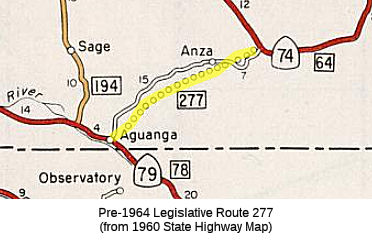
In 1959, Chapter 1062 defined LRN 277 as “[LRN 78] east of Temecula to [LRN 65] east of Anza”.
It appears that instead of building a new alignment for LRN 277 (as
planned in the 1960 state highway map), the Division of Highways opted to
assume maintenance of Cahuilla Road and Kenworthy-Bautista Road. LRN 277
can be seen aligned over Cahuilla Road and Kenworthy-Bautista Road on the
1962 Division of Highways State Map.
(Source: Gribblenation Blog "California State Route 371")
This segment became Route 71 in the 1964 great renumbering. In 1967, this route was first signed as Route 71 from Route 79 E of Temecula to Route 74 E of Anza. In 1974, as a side effect of the creation of I-15 S of I-10, all of Route 71 S of Route 91 was renumbered. The original eastern section, between Temecula and Route 74 E of Anza, was divided into two routes. The portion from what had been US 395 (now I-15) near Temecula to Aguanga was renumbered as part of Route 79 (previously, this stretch had been cosigned as Route 71/Route 79); this stretch was part of LRN 78. The stretch between Aguanga and Route 74 was renumbered as Route 371; this is LRN 277.
© 1996-2024 Daniel P. Faigin.
Maintained by: Daniel P. Faigin
<webmaster@cahighways.org>.
 Route 276
 Route 278