
 California Highways:
Click here for a key to the symbols used. An explanation of acronyms may be found at the bottom of the page.
 Routing
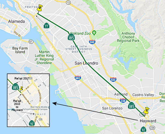 (a) From Route 92 in Hayward to Route 77 in Oakland.
(b) The relinquished former portion of Route 185 within the City of Hayward and within the unincorporated area of the County of Alameda are not a state highway and is not eligible for adoption under Section 81. For the relinquished former portion of Route 185, the City of Hayward and the County of Alameda shall maintain within their respective jurisdictions signs directing motorists to the continuation of Route 185 or to the state highway system, as applicable.
(c) (1) The commission may relinquish to the City of Hayward, to the City of San Leandro, or the County of Alameda all or any portion of Route 185 located within the city limits of that city, or within the unincorporated area of the County of Alameda, as applicable, upon terms and conditions the commission finds to be in the best interests of the state, if the department and the city or county enter into an agreement providing for that relinquishment.
(2) A relinquishment under this subdivision shall become effective immediately after the county recorder’s recordation of the relinquishment resolution containing the commission’s approval of the terms and conditions of the relinquishment.
(3) On and after the effective date of the relinquishment, both of the following shall occur:
(A) The portion of Route 185 relinquished shall cease to be a state highway.
(B) The portion of Route 185 relinquished shall be ineligible for future adoption under Section 81.
(4) For relinquished portions of Route 185, the City of Hayward, the City of San Leandro, and the County of Alameda shall maintain signs within their respective jurisdictions directing motorists to the continuation of Route 185 or to the state highway system, as applicable.
(d) For purposes of this section:
(1) The jurisdiction of the City of Hayward shall refer to all relinquished portions of Route 185 within the City of Hayward.
(2) The jurisdiction of the City of San Leandro shall refer to all relinquished portions of Route 185 within the City of San Leandro.
(3) The jurisdiction of the County of Alameda shall refer to all relinquished portions of Route 185 in the unincorporated area of the County of Alameda.
 Post 1964 Signage History
In 1963, this route was defined as "Hayward to High Street in Oakland."
In 1984, Chapter 409 clarified the routing: "Route 92 in
Hayward to High Street Route 77 in Oakland."
In 2009, AB 1386 (Chapter 291, 10/11/2009) authorized the relinquishment of the portion within the city of Hayward by adding the following:
(b) (1) The commission may relinquish to the City of Hayward the portion of Route 185 located within the city limits of that city, upon terms and conditions the commission finds to be in the best interests of the state, if the department and the city enter into an agreement providing for that relinquishment.
(2) A relinquishment under this subdivision shall become effective immediately after the county recorder's recordation of the relinquishment resolution containing the commission's approval of the terms and conditions of the relinquishment.
(3) On and after the effective date of the relinquishment, both of the following shall occur: (A) The portion of Route 185 relinquished shall cease to be a state highway. (B) The portion of Route 185 relinquished shall be ineligible for future adoption under Section 81.
(4) For relinquished portions of Route 185, the City of Hayward shall maintain signs within its jurisdiction directing motorists to the continuation of Route 185 or to the state highway system, as applicable.
In July 2010, the CTC authorized relinquishment of right of way in the city of Hayward on Route 185 (Mission Boulevard) from Foothill Boulevard to A Street, under terms and conditions stated in the letter dated June 1, 2010, determined to be in the best interests of the State. Authorized by Chapter 291, Statutes of 2009, which amended Section 485 of the Streets and Highways Code.
In 2012, AB 2679 (Chapter 769, 9/29/12) updated the language to reflect the relinquishment in Hayward:
(b) (1) The commission may relinquish to the City of Hayward the portion of Route 185 located within the city limits of that city, upon terms and conditions the commission finds to be in the best interests of the state, if the department and the city enter into an agreement providing for that relinquishment.
(2) A relinquishment under this subdivision shall become effective immediately after the county recorder’s recordation of the relinquishment resolution containing the commission’s approval of the terms and conditions of the relinquishment.
(3) On and after the effective date of the relinquishment, both of the following shall occur:
(A) The portion of Route 185 relinquished shall cease to be a state highway.
(B) The portion of Route 185 relinquished shall be ineligible for future adoption under Section 81.
(4)(b)For relinquished portionsThe relinquished former portion of Route 185 within the City of Hayward is not a state highway and is not eligible for adoption under Section 81. For the relinquished former portion of Route 185, the City of Hayward shall maintainsignswithin its jurisdiction signs directing motorists to the continuation of Route 185 or to the state highway system, asapplicable.applicable, and shall ensure the continuity of traffic flow on the relinquished portion of Route 185, including any traffic signal progression.
In 2015, SB 491, Chapter 451, 10/2/15, removed the language about ensuring the continuity of traffic flow, and added item (c):
(c) (1) The commission may relinquish to the City of Hayward all or any portion of Route 185 located within the city limits of that city, upon terms and conditions the commission finds to be in the best interests of the state, if the department and the city enter into an agreement providing for that relinquishment.
(2) A relinquishment under this subdivision shall become effective immediately after the county recorder’s recordation of the relinquishment resolution containing the commission’s approval of the terms and conditions of the relinquishment.
(3) On and after the effective date of the relinquishment, both of the following shall occur:
(A) The portion of Route 185 relinquished shall cease to be a state highway.
(B) The portion of Route 185 relinquished shall be ineligible for future adoption under Section 81.
(4) For relinquished portions of Route 185, the City of Hayward shall maintain signs within its jurisdiction directing motorists to the continuation of Route 185 or to the state highway system, as applicable.
In 2017, AB 333, Chapter 339, 9/28/2017 amended the text to add relinquishment in unincorporated areas of the county of Alameda. It also provided definitions for Hayward and Alameda.
In October 2017, the CTC authorized relinquishment of right of way in the city of Hayward on Route 185 (Mission Boulevard) from “A” Street to the Hayward city limits at Rose Street (04-Ala-185-PM 0.4/0.9), under terms and conditions as stated in the relinquishment agreement dated August 29, 2017, determined to be in the best interest of the State. Authorized by Chapter 451, Statutes of 2015, which amended Section 485 of the Streets and Highways Code.
In 2018, AB 2473, Chapter 321, 9/10/2018, amended the text to add relinquishment in the City of San Leandro. It also provided definitions for the City of San Leandro.
In January 2019, the CTC authorized relinquishment of right of way in the
unincorporated territory of the county of Alameda (County) on Route 185
(East 14th Street and Mission Boulevard) (04-Ala-185-PM
0.9/3.2), under terms and conditions as stated in the relinquishment
agreement dated November 27, 2018, determined to be in the best interest
of the State. Authorized by Chapter 339, Statutes of 2017, which amended
Section 485 of the Streets and Highways Code.
(Source: January 2019 CTC Minutes, Agenda Item 2.3c)
 Pre 1964 Signage History
This was LRN 105, defined in 1933. North of Davis Street, it was Sign Route 17 until LRN 69 was moved to the Nimitz Freeway routing. It does not appear to have had a sign route number between Route 92 (where LRN 105 turned W to cross the San Mateo-Hayward Bridge (now Route 92)) to S of Davis Street; and after 1947, N of Davis Street.
Sign Route 185 was not defined as part of the initial state signage of routes in 1934. It is unclear what (if any) route was signed as Sign Route 185 between 1934 and 1964. Portions of Route 185 are the older surface street routing for Sign Route 17 (now I-880), combined with an older unsigned routing. Route 185 was created to keep those portions of former Sign Route 17 in the state system. The portion N of the junction with Route 61 in San Leandro (i.e., N of Estudillo) is former Sign Route 17.
 Status
Prior to 2008, Route 77 from the official terminus of Route 185 in Oakland and I-880 was signed as Route 185, making it appear that Route 185 continues to I-880. This was corrected by 2008.
In October 2017, the CTC authorized relinquishment of right of way in the city of Hayward on Route 185 (Mission Boulevard) from “A” Street to the Hayward city limits at Rose Street (04-Ala-185-PM 0.4/0.9), under terms and conditions as stated in the relinquishment agreement dated August 29, 2017, determined to be in the best interest of the State. Authorized by Chapter 451, Statutes of 2015, which amended Section 485 of the Streets and Highways Code.
In January 2019, the CTC authorized relinquishment of right of way in the
unincorporated territory of the county of Alameda (County) on Route 185
(East 14th Street and Mission Boulevard) (04-Ala-185-PM
0.9/3.2), under terms and conditions as stated in the relinquishment
agreement dated November 27, 2018, determined to be in the best interest
of the State. Authorized by Chapter 339, Statutes of 2017, which amended
Section 485 of the Streets and Highways Code.
(Source: January 2019 CTC Minutes, Agenda Item 2.3c)
In December 2025, it was reported that almost immediately after the Tempo
bus line went live on International Boulevard in the summer of 2020,
people flagged its dangers, saying drivers were using the dedicated bus
lane as a mini-freeway to bypass traffic slowdowns, leading to red-light
running at very high speeds — and a rash of pedestrian fatalities.
Finally, starting in the summer of 2024, AC Transit and Oakland’s
transportation department added plastic bollards to cut off access to the
bus lane. And a new interagency report, released at an interagency meeting
of the transit agency and the city on 2025-12-10 in Oakland, shows that
pedestrian deaths on bus rapid transit (BRT) lanes fell from seven in 2023
to zero so far in 2025, partly due to those bollards and other
interventions. Intrusions from private vehicles into the bus lanes have
dropped by 83%, and the speed of cars still making their way illegally
into the lane has fallen, the report found. Megan Wier, assistant director
of transportation, said only three people have died in the bus lane this
year, and none were pedestrians. The quick build added many white rubber
bollards with concrete bases, at 15-foot intervals, between the bus-only
lane and the main roadway. Yellow bollards were also added as medians on
parts of International that were deemed dangerous for opposite-way
drivers. The quick-build project also included additional “25
mph” speed limit and bus-only signs; new paint on bus lanes; arrow
markings to stress which movements are allowed; and six speed cushions,
mostly at bus stops near the Fruitvale BART station, to further discourage
— or at least slow down — drivers in the bus lane. The project
was paid for by a mutual agency fund, with Oakland providing $1.85 million
and AC Transit $400,000 from a federal grant.
(Source: Oaklandside, 12/22/2025)
 Naming
E 14th Street and Mission Blvd.
Historically, this route is close to the original "El Camino Real" (The Kings Road). A portion of this route has officially been designated as part of "El Camino Real by Assembly Bill 1707, Chapter 739, on October 11, 2001.
 Other WWW Links
 Statistics
Overall statistics for Route 185:
 Pre-1964 Legislative Route
In 1933, Chapter 767 added the route from "[LRN 60] near Laguna Beach to [LRN 2] near Irvine" to the highway system. In 1935, this was added to the highway code as LRN 185 with that definition. The definition remained unchanged until the 1963 renumbering.
This route ran from Route 1 near Laguna Beach to US 101 near Irvine. This is Route 133 as defined in 1963 (i.e., present-day non-toll portions).
© 1996-2024 Daniel P. Faigin.
Maintained by: Daniel P. Faigin
<webmaster@cahighways.org>.
 Route 184
 Route 186