
 California Highways:
Click here for a key to the symbols used. An explanation of acronyms may be found at the bottom of the page.
 Routing
 Post 1964 Signage History
In 1963, this route was defined as "Route 36 at Mineral to Route 36 near Morgan."
In 1984, Chapter 409 corrected the terminus: “… to Route 36 near Morgan Summit. ”
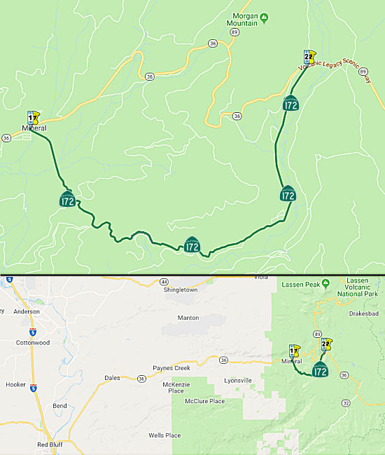
The 12-mile loop of Route 172 was the original LRN 29, the primary route
east of Red Bluff to Susanville and then on to Reno, NV, and, before about
1934, was signed as Route 36. That section, between Mineral and Morgan
Summit, was routed through a narrow valley -- one that just happened to
feature numerous lodges and spas built to take advantages of the numerous
hot springs in that volcanic area. It zig-zagged back and forth across the
valley, serving the various facilities -- but because of the constricted
space in the valley, the roadway was never more than 18 feet wide -- and
was never striped for 2 lanes. In 1934 the route was bypassed by LRN 86,
which was laid out in a large S-curve from Mineral (the present west
junction of Route 36 & Route 172) to LRN 83 (Route 89) south of the
southern entrance to Lassen Park; while not much of a saving in total
mileage, it was a more modern 2-lane facility that not only allowed faster
speeds but also cut about 13 miles off the distance between Red Bluff and
Lassen Park. Route 36 was rerouted over LRN 86 when it was completed,
leaving the LRN 29 loop unsigned until the '64 renumbering, when it was
signed as Route 172. As of 30 years ago, Route 172 was still one lane --
actually narrowing to about 13-14 feet in some sections. Route 172 is a
unique (any one-lane state highway fits that description) short route, but
one that certainly was of little use as a through facility.
Decommissioning of Route 172 has been under discussion for several years
now, but the plug hasn't been pulled as of yet (probably due to objections
by the several property owners along the highway who want to make sure it
gets plowed in winter; it's at about 5700-6000 foot altitude).
(Source: AARoads, "CA 172; one-lane madness and SSR 36 puzzle", 6/25/2017)
 Pre 1964 Signage History
This loop was originally part of Route 36 (a 1934 original state route). It was part of LRN 29, defined in 1909.
 In 1954, it was announced that the CHC had adopted a new routing for a 4.5 mi section of
Sign Route 36 W of Mineral (today ~ TEH R78.065 to TEH 83.134). The new
route swings to the S of the existing highway for a little more than half
of the 4.5 mi then follows the lines of the present highway to Mineral.
Plans at the time called for the building of a modern two-lane highway
over the route. Looking at current maps, it appears the previous highway
is now an unnamed road that connects with Road 140A, which then comes back
to Route 36. Note that the 1954 adoption map also shows that Route 36 had
been routed onto LRN 86, with "Route 29" (LRN 29) now an unsigned route
(eventual Route 172)
In 1954, it was announced that the CHC had adopted a new routing for a 4.5 mi section of
Sign Route 36 W of Mineral (today ~ TEH R78.065 to TEH 83.134). The new
route swings to the S of the existing highway for a little more than half
of the 4.5 mi then follows the lines of the present highway to Mineral.
Plans at the time called for the building of a modern two-lane highway
over the route. Looking at current maps, it appears the previous highway
is now an unnamed road that connects with Road 140A, which then comes back
to Route 36. Note that the 1954 adoption map also shows that Route 36 had
been routed onto LRN 86, with "Route 29" (LRN 29) now an unsigned route
(eventual Route 172)
(Source: Corning Daily Observer, 9/22/1954 via Joel Windmiller,
1/27/2023)
A discussion on AARoads noted that a 1935 topo shows Route 36 on current Route 172. It isn't clear what
is on the alignment of CA 172 on the 1938 state highway map nor on the
1935
Tehama County Map, but the modern alignment of Route 36 for sure was
already present. Route 172 is there by 1963. From the official '63 state
highway map, what is now Route 172 was always part of LRN 29 (Red Bluff -
Nevada along US 395) until the demise of the LRN/SSR dichotomy in '64. LRN 86, from LRN 83/Route 89 up the hill on the way to Lassen NP down to the
west Route 36/Route 172 junction, was physically added to the state
highway system circa 1938, although planning for that bypass (and the
allocation of the LRN 86 designation), specifically to realign Route 36,
preceded construction by several years. Apparently the Division of
Highways wanted to get the one-lane segment, now part of CA 172 -- and the
various facilities along it -- bypassed as much as its regular users did;
that "loop" went unsigned from 1938 to at least 1964.
(Source: AARoads, "CA 172; one-lane madness and SSR 36 puzzle", 6/25/2017)
In 1964, Route 36 was assigned a direct routing between Mineral and Morgan Springs (LRN 86), and the old routing was resigned as Route 172. Research by Tom Fearer indicates signed Route 36 moved to LRN 86 circa 1938-1940; the signage on LRN 29 after that move remains unclear:
Route 36 can be seen for detail for the first time on the 1935 Gousha Highway Map of California. Note; Route 36 is shown traversing LRN 29 by way of what is presently Route 172 over Mineral Summit. It is unclear when Route 36 moved off of LRN 29 over Mineral Summit. One of the few maps I can find showing in fully clear detail Route 36 over LRN 29 via Mineral Summit is the 1935 USGS Map of Payne's Creek. USGS Maps from the 1950s show Route 36 realigned via LRN 86 and LRN 83 over Morgan Summit. A May 1935 Division of Highways Map shows the progress of signing the US Routes and Sign State Routes in California. Route 36 is shown to have been fully signed over Mineral Summit via LRN 29. There seems to be some evidence that Route 36 may have been realigned over Morgan Summit by 1940. The 1940 Division of Highways State Map shows LRN 86/LRN 83 paved over Morgan Summit whereas Mineral Summit on LRN 29 is still shown to be a Oiled Earth or Gravel surface.
(Source: Gribblenation Blog, "California State Route 172", October 2020)
Route 172 was not defined as part of the initial state signage of routes in 1934. It is unclear what (if any) route was signed as Route 172 between 1934 and 1964.
 Other WWW Links
 Status
In April 2005, the CTC considered a resolution to vacate right of way in the County of Tehama, between Engineers Stations 299+00 and 341+00, consisting of highway right of way easement no longer needed for State highway purposes.
 Statistics
Overall statistics for Route 172:
 Pre-1964 Legislative Route
In 1933, the route from "Los Angeles, Boyle Avenue, and 4th Street to [LRN 19] near Walnut Station" was added to the state highway system. In 1935, this route was added to the highway code as LRN 172 with the routing:
"Los Angeles, at the intersection of Boyle Avenue and Fourth Street to [LRN 19] near Walnut Station"
In 1947, Chapter 1233 changed the origin to be "[LRN 2] in Los Angeles".
In 1957, Chapter 1911 simplified the terminus to "…to [LRN 19] near
Walnut
Station".
This was the route from US 101 in Los Angeles to US 60 near Walnut. This was part of the freeway routing of present-day Route 60. Pre-freeway, it run from US 101 and 4th Street, E to 3rd Street, and along Pomona Blvd. Shortly after the Pomono Blvd/Potrero Grande split, it went onto the proposed freeway routing. At one time, it was suggested that it continue E on a new alignment from LRN 19 to the SBD County Line, but this was never accepted.
It was also proposed that the freeway be extended to meet up with the Beverly Hills Freeway (i.e., from the Harbor Freeway to the Hollywood Freeway). This was never accepted.
© 1996-2020 Daniel P. Faigin.
Maintained by: Daniel P. Faigin
<webmaster@cahighways.org>.
 From Route
  Route 171
 Route 173