
 California Highways:
Click here for a key to the symbols used. An explanation of acronyms may be found at the bottom of the page.
 Routing
 Post 1964 Signage History
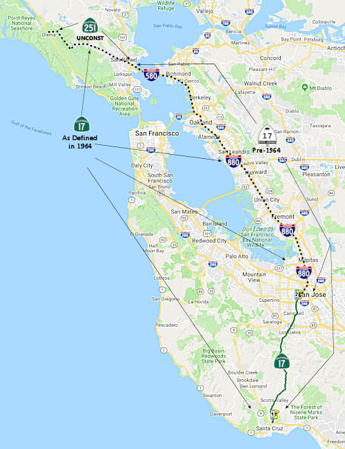
In 1963, Route 17 was defined as "(a) Route 1 near Santa Cruz to Route 101 near Story Road. (b) Route 101 near San Jose to Route 680 near Warm Springs. (c) Route 680 near Warm Springs to Route 580 in Oakland. (d) Route 80 near Albany to the Richmond-San Rafael Bridge Toll Plaza. (e) Point San Quentin to Route 101 near San Rafael. (f) Route 101 near San Rafael to Route 1 near Point Reyes Station."
Note: For detailed discussions on segment (f) see Route 251. For segment (d) and (e), see I-580.
In 1965, sections (a), (b), and (c) were combined, sections (d) and (e) were combined, giving "(a) Route 1 near Santa Cruz to Route 80 in Oakland. (b) Route 80 near Albany to Route 101 near San Rafael via the Richmond-San Rafael Bridge. (c) Route 101 near San Rafael to Route 1 near Point Reyes Station.".
In 1984, Chapter 409 truncated the route significantly, leaving Route 17 as only "from Route 1 near Santa Cruz to Route 280 in San Jose." The portion from Route 280 to Route 80 was renumbered as I-880; and the former (b), Route 80 near Albany to Route 101 near San Rafael, was transferred to I-580. Former (c), Route 101 near San Rafael to Route 1 near Point Reyes Station, was added to Route 251. This latter portion was to have been the "Point Reyes" Freeway. The 1984 act also gave high priority to the improvement of the former (b) as part of I-580.
Originally, Route 17 entered San Jose via Bascom Avenue, then continued east via Stevens Creek Boulevard to Race Street, then north on Race Street. At Race and The Alameda (US 101 at the time, now Route 82), Route 17 northbound and US 101 southbound continued co-signed east on The Alameda and West Santa Clara Street past what is now HP Pavillion (San Jose Arena). At Market Street, US 101 turned southbound; Route 17 continued northeast on Santa Clara to 13th Street, at which point it turned northbound on 13th (which became Oakland Road past Bayshore Highway).
The beginning of the 1963 segment (b) [Route 101 near San Jose...] (as
opposed to "at Story Road", which is in the definition of I-280) could
imply that instead of the second segment representing current I-680
between US 101 and Route 262, the 1963 notion represented the surface
street routing along Oakland Road (later to be signed as Route 238), with
I-680 being the only legislatively defined number for all of current Route 262 and all of the Route 17/I-880 from I-280 to Route 262. This might
imply that the sgment of I-680 from Route 262 to US 101 was first planned
in 1965. It appears the original plans were for Route 17 to have
turned east in San Jose onto what is now I-280, crossed US 101, and then
joined with I-680 in Fremont using the present-day I-680 alignment. I-280
would have turned north on present-day I-880 (then signed as Route 17) at
Route 17, switched to I-680 at US 101, and then would have joined the
proposed Route 17 at Fremont near Route 262. Apparently, Route 17 would
have crossed over somewhere at that point to its then-existing routing up
to Oakland.
(*: Credit for the surmisings regarding 1963-1965
I-680 should go to Chris Sampang)
On a related note, for a short time Route 17 was placed on what is known as Oakland Road, which runs just east of the present-day I-880 between San Jose and Milpitas. It became Main Street in Milpitas and then met present-day Route 262 in Fremont at Warm Springs Blvd and Mission Blvd. Today's I-880 freeway was just signed as I-680 then. Later on, after the new I-680 alignment was finalized, Oakland Road and Main Street were signed as Route 238, since that portion of Mission Blvd south of the present terminus of Route 238 was signed as Route 238 to Warm Springs. Today's I-880 freeway was signed as Route 17 and Temporary I-680 north of US 101 to the junction of Route 262 and Route 17 and Temporary I-280 south of US 101 to the junction of US 280. Note that Mission Blvd crosses I-680 twice. At the first (northern) crossing it is signed as Route 238 and this is the present terminus of Route 238. At the second (southern) crossing it is signed as a connection to I-880; this is the eastern terminus of (unsigned) Route 262. Also, the city of Milpitas built a new alignment for Main Street, so present-day maps do not show how Oakland Road connected with Mission Blvd in Warm Springs via Main Street. According to Chris Sampang, a mile-long segment of road between today's Railroad Court and Hanson Court was part of the old Route 238 (and before that Route 9 and 17), as was Milpitas Boulevard and Warm Springs Boulevard going north to Mission Boulevard/today's Route 262. Prior to the Nimitz Freeway being constructed in the late 1950s, Mission Boulevard ended at Warm Springs Boulevard (thus this was the original south terminus of Route 21, and the point where Route 9 switched alignments) in Fremont. North of there, Route 17 originally continued up Warm Springs Boulevard, then to Warm Springs Court and a now-severed crossing over the railroad (which apparently was removed when a second set of parallel tracks was added in the 1980s) to Lopes Court and Old Warm Springs Boulevard, connecting to Fremont Boulevard northbound. The freeway portion from US 101 was constructed by 1955.
With respect to former segment (2), from Route 80 near Albany to Route 101 near San Rafael: The section from the junction of I-80 and I-580 ("McArthur Freeway" or "the Maze") to the interchange at Hoffman Blvd (approximately 3 miles), was signed as I-80 and Route 17.
Before the completion of the freeway portion between the Hoffman Blvd/I-80 Interchange to the foot of the San Rafael Bridge, the Route 17 routing was as follows: Hoffman Blvd, to Cutting Blvd, to Standard Ave, and then to the foot of the Richmond-San Rafael bridge.
 Pre 1964 Signage History
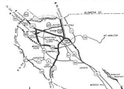 Route 17 was not defined as
part of the original signage of state routes in 1934. However, by 1935, it
appears that the original signed Route 13 was renumbered as Route 17 (as
evidenced by multiple 1935 gas company maps that show the route as Route 17, not Route 13). Between Santa Cruz and San Jose, this was LRN 5,
defined in 1909. Portions of this route existed in 1935. The routing
between Santa Cruz and San Jose appears to have been completed in 1940,
although much of it was three lanes (suicide lane in the center). The only
exception is the portion through the now-submerged towns of Lexington and
Alma; with the construction of the reservoir, the alignment was moved to
the west around 1950. The last section of freeway opened in San Jose was
the section between Bascom Ave and US 101; this opened in 1960. Until this
was completed, the Route 17 routing was from San Carlos Street, then Race
Street, The Alameda, onto Santa Clara Street. From Santa Clara Street,
13th Street, Old Bayshore Highway, to the end of the Nimitz Freeway at
Gish Road.
Route 17 was not defined as
part of the original signage of state routes in 1934. However, by 1935, it
appears that the original signed Route 13 was renumbered as Route 17 (as
evidenced by multiple 1935 gas company maps that show the route as Route 17, not Route 13). Between Santa Cruz and San Jose, this was LRN 5,
defined in 1909. Portions of this route existed in 1935. The routing
between Santa Cruz and San Jose appears to have been completed in 1940,
although much of it was three lanes (suicide lane in the center). The only
exception is the portion through the now-submerged towns of Lexington and
Alma; with the construction of the reservoir, the alignment was moved to
the west around 1950. The last section of freeway opened in San Jose was
the section between Bascom Ave and US 101; this opened in 1960. Until this
was completed, the Route 17 routing was from San Carlos Street, then Race
Street, The Alameda, onto Santa Clara Street. From Santa Clara Street,
13th Street, Old Bayshore Highway, to the end of the Nimitz Freeway at
Gish Road.
In the background material for a CTC agenda item on that road, it is
noted "Soquel San Jose Road is a cut through route which bypasses the
primary north/south route taking traffic directly from the Summit Road
exit on Route 17, to the Porter Street exit on Route 1, in Soquel. Soquel
San Jose Road was a former highway of this region and serves a high
volume of commute traffic on a normal day, and during emergencies. In
addition, when Route 17 is blocked, it becomes the primary bypass Route 17." Soquel San Jose Road connects with Summit Road, which then connects
with Old Santa Cruz Highway. That may also be a former routing ("Old Santa
Cruz Highway") that starts near the Lexington Reservoir (2.2 miles south
of the Santa Cruz Avenue Y in Los Gatos), continuing south to Holy City at
Route 17 and returning to Route 17 near Glenwood. However, the Highway Transportation Survey map of 1934 for Santa Cruz county
shows Soquel San Jose Road as a major county highway, although Old Santa
Cruz highway is shown on the map as State Highway.
(Source: May 2023 CTC Agenda, Agenda Item 2.1b.(18))
 The original routing of Route 17 continued from what is now I-280
into Oakland, following the present I-880 route. As freeway, the first
sections of this route in Oakland date back to the 1940s. In 1949, the
routing of Route 17 from San Jose to Oakland consisted of Old Oakland Road
through Milpitas, Main Street, then onto Warm Springs Road, to Irvington.
At Irvington onto Fremont Blvd, onto Hesperian Blvd, onto E 14th Street
(now Route 185). One report indicates that a 1936 map showed Route 17 in
place, turning off of E. 14th Street onto Davis St (now Route 112) to
Hegenberger (this now appears to be part of Doolittle Drive). Unlike
present-day Route 112, 1936 Route 17 continued down Hegenberger to
Maitland Drive (now Ron Cowan Parkway and part of Harbor Bay Parkway). It
continued along Maitland Drive to what is now Island Drive (then, it was
still Maitland Drive). It crossed San Leandro Bay along Maitland Dr. (now
part of Doolittle Drive - Route 61 -- note that Route 61 has a new routing
along Doolittle Drive bypassing this old routing, due to the airport
rebuild, to Route 112). Whereas present-day Route 61 goes along Otis to
Broadway to Encinal, 1936 Route 17 turned on Clay (which now may be Otis
-- streets have been reworked in this area) to High, continuing to Santa
Clara Ave. It continued along Santa Clara to Webster Street. It then
turned right (joining what is present-day Route 61) going through the
Posey tube, into Alameda, following the present-day Route 61, onto
Harrison Street where it rejoined 14th Street, and then to San Pablo (see
Old Oakland, 1936). By 1949, it was avoiding all that and continuing along E 14th (which turned into
International) to 1st and then back to 14th, where at San Pablo Ave it
transitioned into US 40.
The original routing of Route 17 continued from what is now I-280
into Oakland, following the present I-880 route. As freeway, the first
sections of this route in Oakland date back to the 1940s. In 1949, the
routing of Route 17 from San Jose to Oakland consisted of Old Oakland Road
through Milpitas, Main Street, then onto Warm Springs Road, to Irvington.
At Irvington onto Fremont Blvd, onto Hesperian Blvd, onto E 14th Street
(now Route 185). One report indicates that a 1936 map showed Route 17 in
place, turning off of E. 14th Street onto Davis St (now Route 112) to
Hegenberger (this now appears to be part of Doolittle Drive). Unlike
present-day Route 112, 1936 Route 17 continued down Hegenberger to
Maitland Drive (now Ron Cowan Parkway and part of Harbor Bay Parkway). It
continued along Maitland Drive to what is now Island Drive (then, it was
still Maitland Drive). It crossed San Leandro Bay along Maitland Dr. (now
part of Doolittle Drive - Route 61 -- note that Route 61 has a new routing
along Doolittle Drive bypassing this old routing, due to the airport
rebuild, to Route 112). Whereas present-day Route 61 goes along Otis to
Broadway to Encinal, 1936 Route 17 turned on Clay (which now may be Otis
-- streets have been reworked in this area) to High, continuing to Santa
Clara Ave. It continued along Santa Clara to Webster Street. It then
turned right (joining what is present-day Route 61) going through the
Posey tube, into Alameda, following the present-day Route 61, onto
Harrison Street where it rejoined 14th Street, and then to San Pablo (see
Old Oakland, 1936). By 1949, it was avoiding all that and continuing along E 14th (which turned into
International) to 1st and then back to 14th, where at San Pablo Ave it
transitioned into US 40.
On AAroads, Scott Parker provided the following additional background on
Route 17: There was a bit of controversy regarding just where the signed
state route from San Jose to Oakland would run. The plans for original US 101E -- up former US 48 from San Jose to Castro Valley via LRN 5 -- were
essentially set in stone (US 101W would use LRN 2 up the peninsula); it
would then use the Foothill (later MacArthur) corridor to Lake Merritt,
then twist its way to downtown to the ferry terminal near today's Jack
London Square. But that left two other parallel routes: what would later
become the surface route of Signed Route 17 from Warm Springs through
central Fremont and Union City and on via Hesperian, Llewellyn, and
Washington boulevards to downtown San Leandro (LRN 69). But the northern
extension of LRN 105 from Hayward to that same point in San Leandro also
figured into the mix. Also, the city of Alameda didn't want to be left
out; once the Posey Tube was open, it wanted an signed route to serve it.
Apparently at one point -- since the numbers jumped by 4 from west to east
-- Route 13 was planned to use LRN 69 up to San Leandro, where it "bumped"
into LRN 105; it would then have turned west on Davis St. (today's Route 112 but then the continuation of LRN 69) west to Doolittle, where it would
trace present Route 61 north into Alameda, then back to Oakland (on
present Route 260) via the tube. East 14th Street, which hosted LRN 105
both north and south of San Leandro, was to have become the original Route 17 as it was east of the Route 13 corridor. But that plan never got past
the planning stage; some parties objected to the "13" number, and it was
decided to jettison the dual-signage plan, stick with 17, but omit any
signage along LRN 105 between Hayward and San Leandro (today's
in-process-of-relinquishment Route 185) as well as through the Alameda
loop for the time being -- which of course was delayed over 30 years until
the 1964 renumbering. Of course the convoluted Route 17 path in Alameda
County was obviated when the Nimitz Freeway was constructed in the '50's.
Additionally, the Richmond city streets over which the original Route 17
traveled weren't brought into the state network until just before the
Richmond-San Rafael bridge opened in '57; the freeway connection next to
Franciscan Blvd. up to US 101 in San Rafael was part of the overall bridge
project and was effectively "new-terrain" construction.
(Source: AARoads, "Re: CA 17", 1/31/2020)
Other sections (such as between Route 262 and US 101) date back to the mid-1950s. The section south of US 101 opened around 1960. A 1946 San Jose proposal called for a Route 5 Highway approximately in Route 17's path, with overpasses at the Alameda and San Carlos streets, paralleling Race Street to the east. The "Route 5 freeway" from Los Gatos to Bascom Avenue opened on 4/30/1959. [Thanks to Scott "Kurumi" Oglesby for much of this information]
At I-280 (as of 1963 unbuilt, but LRN 239 to the W and LRN 5 to the E), Route 17 became LRN 239 (still signed as Route 17), and continued N to the junction with Bypass US 101 (LRN 68). Before LRN 239 was defined in 1961, it was likely that Route 17 was LRN 5. This route was at one time signed as US 101E, and was likely the original 1926 US 101.
Route 17 then continued N along present I-880, and was LRN 69 until
its junction near Emeryville with US 40/US 50 (LRN 68 and LRN 5). LRN 69
was defined in 1933. In the Oakland area, Route 17 was signed along LRN 105 until LRN 69 was moved to the Nimitz Freeway routing (before 1947, in
the Oakland area, LRN 69 was used for post-1964 Route 112, Route 61, and
Route 260).
 In 1952, the CHC adopted a routing for the Eastshore Freeway routing of Route 17. The routing starts
from Sign Route 9 (now I-680) just N of its junction with Sign Route 17
(I-880) near Warm Springs, and runs SE joining the proposed Eastshore
Freeway near Railroad Avenue.
In 1952, the CHC adopted a routing for the Eastshore Freeway routing of Route 17. The routing starts
from Sign Route 9 (now I-680) just N of its junction with Sign Route 17
(I-880) near Warm Springs, and runs SE joining the proposed Eastshore
Freeway near Railroad Avenue.
(Source: Palo Alto Times, 1/17/1952 via Joel Windmiller, 2/13/2023)
 In 1955, the CHC considered adoption of a freeway routing from the Eastshore Freeway
(US 40, Sign Route 17) in Albany to the approach to the Richmond-San
Rafael Bridge. This segment was a continuation of Sign Route 17, and would
be later renumbered as part of I-580. The plan calls for an 8-lane
freeway 5.8 mi in length from the El Cerrito Overhead near Golden Gate
Fields to the approach to the Richmond-San Rafael Bridge at Marine St.
There would be no change to the one-mile portion that lies in Albany.
In 1955, the CHC considered adoption of a freeway routing from the Eastshore Freeway
(US 40, Sign Route 17) in Albany to the approach to the Richmond-San
Rafael Bridge. This segment was a continuation of Sign Route 17, and would
be later renumbered as part of I-580. The plan calls for an 8-lane
freeway 5.8 mi in length from the El Cerrito Overhead near Golden Gate
Fields to the approach to the Richmond-San Rafael Bridge at Marine St.
There would be no change to the one-mile portion that lies in Albany.
(Source: Oakland Tribune, 1/27/1955 via Joel Windmiller, 2/16/2023)
 Business Routes
Scotts Valley Blvd in Scotts Valley
 Status
Santa Cruz (Route 1) to Los Gatos (Route 9)
In May 2019, it was reported that SB1 funds were funding the Expedited
Traffic safety enhancement project, which will extend from the Santa Cruz
County line to Alma College Road in Los Gatos. It is scheduled to start in
January 2021 and end 10 months later, according to a press release.
Improvements include vegetation control, pavement restoration in both
directions, speed feedback signs, curve ahead warning signs with flashing
beacons in both directions, an electronic message sign in the northbound
direction, enhanced striping and right edge line rumble strips, safety
lighting, overhead warning signs with flashing beacons, guardrail systems
and channelizers, or flexible retroreflective devices to discourage
drivers from crossing road lines. Pavement restoration will include high
friction surface treatment to create better traction on wet pavement. A
proposed six speed limit signs will accompany the “curve
ahead” warning signs with speed limits printed on them. The safety
enhancement project is expected to cost nearly $7.35 million, according to
Chris Mayfield, Caltrans District 4 acting chief public information
officer.
(Source: Santa Cruz Sentinal, 5/9/2019)
Highway 17 Management Access Plan
In October 2015, it was reported that Caltrans,
agencies in Santa Cruz and Santa Clara counties and Scotts Valley are
beginning what is called the Highway 17 Access Management Plan. More
information is at www.ca-hwy17amp.org.The Highway 17 Access Management Plan (Hwy 17 AMP) is a long-range plan that
will provide access management strategies and recommendations to address
access, mobility, and safety needs in the Route 17 corridor. These
recommendations are intended to help reduce conflict points and preserve
the functional integrity of the corridor as a safe and efficient
interregional corridor. The plan will promote environmental and economic
sustainability by coordinating land use and transportation planning. Access
management is a term used by transportation professionals for the
management of locations where vehicles enter and exit the roadway. Conflict
point is a term used by transportation professionals to describe an
area where two vehicles’ paths can either cross, merge, or diverge.
An entrance to a highway (access point) can have one or more conflict
points. Each conflict point represents a location where a collision may
occur.
(Sources: San Jose Mercury News, 11/23/2015; Hwy 17 AMP)
In June 2016, it was reported that Caltrans wants to
improve how motorists get on and off the congested corridor in Santa Cruz
County and was starting to hold community meetings to allow the public to
weigh in. One potential change is closing and consolidating some of the
many intersections and driveways along the route that interrupt traffic
flow and cause collisions. Other ideas include installing median barriers,
adding ramps, lanes and frontage roads as well as building underpasses so
motorists don’t have to crossover the four-lane highway and then
merge into the fast lane. These proposals are part of the draft Highway 17
Management Access Plan, a long-range document that will include
improvements to make in the next two decades. The focus is on the 7 miles
between Summit Road to Granite Creek Road in Scotts Valley. Within this
serpentine stretch, there are 59 driveways or turnoffs — and many
white-knuckled drivers. In 2015, crashes on the curvy road hit the highest
level in a decade. There were 664 crashes — the highest since 695
collisions in 2005.
(Source: Santa Cruz Sentinel, 6/2/2016)
Southbound Route 17 Connector Realignment (05-SCR-01 16.7/17.0, 05-SCR-17 0.0/0.3)
In August 2016, the CTC authorized funding for a project on Route 1, in and near Santa Cruz (05-SCR-01 16.7/17.0), from 0.1 mile south of Route 1/Route 17 Separation to 0.4 mile south of Pasatiempo Overcrossing; also on Route 17 (PM 0.0/0.3). Realign southbound Route 17 connector to southbound Route 1. $658K for right of way acquisition, and $5,811K for construction. The project (PPNO 2636) was included in the final adopted 2018 SHOPP in March 2018.
In October 2018, the CTC approved an allocation of
$8,508,000 for the State Highway Operation Protection Program (SHOPP)
Collision Reduction Safety Improvement project (PPNO 2422) on Route 17, in
Santa Cruz County. This project proposes to improve safety of Route 17
(southbound) in Santa Cruz County from the southbound exit ramp to Route 1
to the entrance ramp from Pasatiempo Drive. Due to the higher than average
collision rate, the project proposes to construct a retaining wall and
widen the outside shoulder to 10 feet to improve stopping sight distance.
This section of Route 17 is experiencing a pattern of roadway departure
collisions, often when the pavement is wet. This existing ROute 17
(southbound) has a one (1) to 4-foot outside shoulders with limited
stopping sight distance, because of the hillside cut slope between SCL 0.2
and SCL 0.5. This project will widen the outside shoulder to 10 feet;
widening the outside shoulder will improve the stopping sight distance to
500 feet for a design speed of 55 mph. The project was programmed in the
2016 SHOPP for a construction allocation in Fiscal Year 2017-18; which is
from July 1, 2017 to June 30, 2018. If the Department does not obtain an
allocation during this programmed fiscal year, a time extension for the
Construction allocation is required to keep the project programming
active. On June 28, 2018, the Commission approved a four-month time
extension for this project that will expire on October 31, 2018. Storm
damage in Fiscal Year 2016-17 caused a major slope failure within the
limits of the project. While current best practice is to obtain
geotechnical investigations early in the Project Approval and
Environmental Document (PA&ED) phase, the storm damage priorities
delayed that work. As this is a collision reduction project, the
Department determined that it was best that the project move forward with
the preliminary geotechnical information, and follow up with the more
detailed geotechnical investigations during during Plans, Specifications
and Estimate (PS&E) phase. Ultimately, the storm damage work delayed
the geotechnical drilling until late in the PS&E phase.
(Source: October 2018 CTC Agenda Item 2.5d.(2))
In August 2020, the CTC received notice of the
following delegated allocation: $7,913,000. 05-SCr-1 16.7/17.0. PPNO
05-2636 ProjID 0516000020 EA 1H060. Route 1 In and near Santa Cruz, from
0.1 mile south of Route 1/Route 17 Separation to 0.4 mile south of
Pasatiempo Overcrossing; also on Route 17 (PM 0.0/0.3). Outcome/Output:
Improve safety by realigning connector ramp, constructing concrete
barrier, and adding high visibility striping on southbound Route 17
connector to southbound Route 1. This project will reduce the number and
severity of collisions.
(Source: August 2020 CTC Agenda, Agenda Item
2.5f.(3) #5)
In March 2012, it was reported that an innovative pavement technique was being tried on Laurel Curve (~ SCR 9.442-9.692). A high-friction surface that resembles sandpaper will be laid down over a few hundred feet at the southbound downhill curve. The thin, one-eighth-inch epoxy is being tried at a handful locations across the country and at another location in Southern California. The goal is to reduce the number of crashes. From 2004 to September 2010, 1 of every 4 accidents on the Santa Cruz County side of Route 17 occurred at this harrowing, twisty stretch south of Summit Road. The surfacing technique is also being used on the Sepulveda Blvd offramp from I-105. When driven over, the new surface will be a noisy, rough ride that is expected to slow drivers down. An electronic warning sign that shows one's speed will be installed before the curve later in 2012, and in 2014-2015, the shoulders will be widened and a taller guardrail installed. Caltrans may also consider installing a center divider to prevent southbound motorists from veering into northbound lanes and causing head-on crashes.
Route 17 Wildlife Mitigation Project (~ SCR 9.442-9.692 and SCL 4.09)
 In October 2016, it was reported that two new tunnels under Route 17 — one near Lexington Reservoir in Santa Clara County
(~ SCL 4.09), the other near Laurel Curve in Santa Cruz County (SCR
9.442-9.692) — will provide much-needed links in an area where home
construction and asphalt have fragmented once-continuous habitat,
connecting two major wilderness areas where animals roam for food, mates
and new territory. The recently unveiled construction projects —
which will cost up to $32 million and be funded by a grab bag of private,
county and state sources — are among the most ambitious in an
expanding national effort to reduce roadside carnage. The goal of the
Santa Cruz Mountains projects is not just to save motorist and animal
lives. Advocates envision a future landscape in which large populations of
wildlife can thrive, avoiding the genetic perils of isolated clusters
trapped in shrinking and fragmented habitats. A key part of the Route 17
projects was identifying exactly where animals cross. Teams analyzed data
from three sources: roadkill, collected by Caltrans; radio signals, from
collars worn by pumas; and motion-detecting cameras, along existing
culverts. Then they they overlaid the crossing points onto highway maps to
select the ideal spots for constructing the tunnels. The highway presents
unique challenges to excavation. It is a busy, winding and narrow state
road with steep topography and unstable geology, traversing two different
counties. The tunnels must be wide enough to be inviting to animals. The
Santa Clara County tunnel could measure up to 400 feet long; the Santa
Cruz County tunnel, where the route is a bit narrower, could be as short
as 120 feet. They’ll require wire fencing to funnel wildlife into
safe passage. A wide range of species are expected to be helped by the
tunnels and fences, which will need to be both tall and deep. In addition
to mountain lions and deer, the new corridors will aid animals such as
bobcats, gray foxes, coyotes, skunks, raccoons and even Western pond
turtles. In late October, Caltrans agreed to spend $3.1 million to help
build a tunnel under Route 17 in Santa Cruz County, a project expected to
make the busy route safer for both wildlife and humans. This means that
the design work at the site, called Laurel Curve, could begin in a few
months. If additional funding is secured through Measure D, a half-cent
sales tax for transportation projects in Santa Cruz County that passed
with a 67.78% margin, the tunnel could be built by 2020. Meanwhile, the
Land Trust of Santa Cruz is purchasing property on either side of the
road, so that the new “wildlife corridor” is not developed for
housing. The non-profit has bought and protected two properties totaling
290 acres on the east side of the highway, and is currently raising funds
to purchase a conservation easement on 170.5 acres west of Laurel Curve on
the so-called “Marywood property,” owned by the Dominican
Sisters of San Jose. Laurel Curve region is a route for animals because it
holds the largest undeveloped parcels along Route 17. The route follows
two major drainage basins. One, on the east, leads to a branch of Soquel
Creek and the protected Forest of Nisene Marks State Park. The other, on
the west, leads to Bean Creek and the San Lorenzo River, then the sea. The
Laurel Curve tunnel will be about 120 feet long. Fencing is also required,
to funnel wildlife into safe passage. The tunnel will cost $8 to $12
million to build. If Measure D passes, $5 million will be contributed to
construction of the tunnel. Land Trust Executive Director Stephen Slade
says the Land Trust has committed $3 million for construction of the
tunnel, which will be raised from individuals as part of its “Great
Land and Trail Campaign.” The Land Trust is still $2 million short
of the $6.5 million it needs. To help the Land Trust reach their goal, an
anonymous donor will double all gifts to the Land Trust’s wildlife
crossing campaign through Thursday, October 27, 2017.
In October 2016, it was reported that two new tunnels under Route 17 — one near Lexington Reservoir in Santa Clara County
(~ SCL 4.09), the other near Laurel Curve in Santa Cruz County (SCR
9.442-9.692) — will provide much-needed links in an area where home
construction and asphalt have fragmented once-continuous habitat,
connecting two major wilderness areas where animals roam for food, mates
and new territory. The recently unveiled construction projects —
which will cost up to $32 million and be funded by a grab bag of private,
county and state sources — are among the most ambitious in an
expanding national effort to reduce roadside carnage. The goal of the
Santa Cruz Mountains projects is not just to save motorist and animal
lives. Advocates envision a future landscape in which large populations of
wildlife can thrive, avoiding the genetic perils of isolated clusters
trapped in shrinking and fragmented habitats. A key part of the Route 17
projects was identifying exactly where animals cross. Teams analyzed data
from three sources: roadkill, collected by Caltrans; radio signals, from
collars worn by pumas; and motion-detecting cameras, along existing
culverts. Then they they overlaid the crossing points onto highway maps to
select the ideal spots for constructing the tunnels. The highway presents
unique challenges to excavation. It is a busy, winding and narrow state
road with steep topography and unstable geology, traversing two different
counties. The tunnels must be wide enough to be inviting to animals. The
Santa Clara County tunnel could measure up to 400 feet long; the Santa
Cruz County tunnel, where the route is a bit narrower, could be as short
as 120 feet. They’ll require wire fencing to funnel wildlife into
safe passage. A wide range of species are expected to be helped by the
tunnels and fences, which will need to be both tall and deep. In addition
to mountain lions and deer, the new corridors will aid animals such as
bobcats, gray foxes, coyotes, skunks, raccoons and even Western pond
turtles. In late October, Caltrans agreed to spend $3.1 million to help
build a tunnel under Route 17 in Santa Cruz County, a project expected to
make the busy route safer for both wildlife and humans. This means that
the design work at the site, called Laurel Curve, could begin in a few
months. If additional funding is secured through Measure D, a half-cent
sales tax for transportation projects in Santa Cruz County that passed
with a 67.78% margin, the tunnel could be built by 2020. Meanwhile, the
Land Trust of Santa Cruz is purchasing property on either side of the
road, so that the new “wildlife corridor” is not developed for
housing. The non-profit has bought and protected two properties totaling
290 acres on the east side of the highway, and is currently raising funds
to purchase a conservation easement on 170.5 acres west of Laurel Curve on
the so-called “Marywood property,” owned by the Dominican
Sisters of San Jose. Laurel Curve region is a route for animals because it
holds the largest undeveloped parcels along Route 17. The route follows
two major drainage basins. One, on the east, leads to a branch of Soquel
Creek and the protected Forest of Nisene Marks State Park. The other, on
the west, leads to Bean Creek and the San Lorenzo River, then the sea. The
Laurel Curve tunnel will be about 120 feet long. Fencing is also required,
to funnel wildlife into safe passage. The tunnel will cost $8 to $12
million to build. If Measure D passes, $5 million will be contributed to
construction of the tunnel. Land Trust Executive Director Stephen Slade
says the Land Trust has committed $3 million for construction of the
tunnel, which will be raised from individuals as part of its “Great
Land and Trail Campaign.” The Land Trust is still $2 million short
of the $6.5 million it needs. To help the Land Trust reach their goal, an
anonymous donor will double all gifts to the Land Trust’s wildlife
crossing campaign through Thursday, October 27, 2017.
(Source (including map): Mercury News, 10/15/2016; EastBay
Times, 10/20/2016)
In October 2016, the CTC amended the SHOPP to include the Route 17 Wildlife Crossing near the City of Scotts Valley in Santa Cruz County for pre-construction project development, with the understanding that construction capital funding will be provided through $5 million in county sales tax measure funding that is earmarked in a November 2016 local ballot measure plus approximately $3 million in private funding to be raised by the Land Trust of Santa Cruz County (Land Trust). The area of Laurel Curve, near the City of Scotts Valley, has been identified as a key location for wildlife crossings. To help reduce wildlife mortality due to being struck by vehicles, the Land Trust purchased land on either side of Route 17, totaling approximately 290 acres, with the intent of creating a wildlife crossing at that location. The Land Trust has been working with the Santa Cruz County Regional Transportation Commission, the CDFW and the Department to develop and fund the construction of a wildlife undercrossing at Laurel Curve. The crossing will connect the properties owned by the Land Trust, which in turn provide connectivity to other wildlands on either side of the highway and creates a wildlife corridor enabling animals to safely cross the highway. The Department may also provide construction support and will determine the funding amount as the project is developed. The California Department of Fish and Wildlife (CDFW) has committed to provide the Department mitigation credits that would be generated by this project, credits that can be used in the future for specified mitigation purposes on other Department project(s) within the Santa Cruz Mountains Bioregion. The CDFW, through authority granted by Assembly Bill 2087 (Levine), has committed to provide specified mitigation credits to offset fish, wildlife and habitat resource impacts under CEQA Public Resources Code Section 21000 for future transportation projects. This particular project at Laurel Curve is the first such project under this authority and is being used by both the Department and CDFW as a pilot project that will not only provide needed benefits at the project location but will also establish processes between the Department and the CDFW that can be used to guide future projects that establish advance mitigation credits. The partnership is futher broadened to include the regional transportation planning agency and private entities. This project holds the promise of addressing wildlife mitigation issues early on at a regional or landscape level, thus reducing uncertainty and time in the environmental phase of future transportation projects while enabling large scale, long term habitat connectivity planning and implementation.
In May 2018, it was reported that sometime in 2021,
construction should begin on Route 17 at Laurel Curve — not a road
widening or a curve correction but a new bridge designed to save the lives
of mountain lions and deer crossing the road and reduce costly and
injurious collisions with wildlife. The Caltrans solution, estimated to
cost $12 million, has morphed in five years from a tunnel to “the
most optimal design,” a 60-foot roadway bridge with an undercrossing
to give large animals safe passage, according to Nancy Siepel, a Caltrans
biologist. Laurel Curve was selected because this is where a majority of
mountain lions roaming to the Diablo Range and the Gabilan Mountains cross
Route 17, according to data from the Santa Cruz Puma Project, a UC Santa
Cruz study that began in 2008. It’s the first stand-alone wildlife
crossing planned in Caltrans District 5, which encompasses Santa Cruz,
Monterey, San Luis Obispo, San Benito and Santa Barbara counties. Caltrans
describes it as a stand-alone crossing because it’s not being built
as part of a highway improvement project. In Santa Cruz County, 55 deer
and five mountain lions have been hit and killed in 15 years on Route 17,
according to ecologist Tanya Diamond of Pathways for Wildlife, with more
roadkill incidents in Santa Clara County. The Land Trust of Santa Cruz
County was an early champion of the Route 17 wildlife crossing, raising
funds in 2015 and 2016 from donors to secure conservation easements for
463 acres on both sides of highway. Building is restricted in those areas,
said Stephen Slade, executive director of the land trust. The Land Trust
of Santa Cruz County providing $3 million for construction, and Measure D,
the Santa Cruz County transportation sales tax, is providing $5 million.
Caltrans is funding the environmental review and design work for the
bridge. The project will take two years to design then six months to
advertise and award the bid. In order to keep four lanes open, Caltrans
will barricade a third, shift traffic over, put the roadbed down and do
that three times. Engineers have to look at the weight the bridge will
carry, soils and traffic. The contractor will drill piles to support the
new structure and put new slabs down, one third at a time.
(Source: Santa Cruz Sentinel, 5/12/2018)
In July 2019, it was reported that the first animal
corridor to bridge Route 17 is on track to be completed in 2022 as the
last piece of financing for the $12 million project fell into place this
week. Land Trust Santa Cruz County announced completion of a $5 million
fundraising campaign Tuesday, $3 million of which was raised in support of
the plan to tunnel beneath Route 17’s most dangerous stretch of
roadway for mountain lions and other critters. Expected to break ground in
2021, the project aims to connect key wildlife habitat on either side of
the busy highway by digging underneath Laurel Curve — turning the
stretch of highway into a bridge beneath which animals can freely cross.
Laurel Curve, 3 miles south of Summit Road, is the most frequent site of
animal crossings on the Santa Cruz County side of Route 17, according to
data compiled by Caltrans. It’s also the deadliest: mountain lions,
bobcats, coyote, skunks and deer are regularly struck on the stretch of
highway traveled by more than 65,000 motorists each day. A partnership
between the Land Trust, the county Regional Transportation Commission and
Caltrans, the Route 17 animal crossing is also supported by $5 million in
county Measure D transportation funds and $3 million from Caltrans.
Remaining funds from the Land Trust campaign are slated to support a
second wildlife crossing effort to bridge Route 129 and US 101, connecting
the Santa Cruz Mountains to the Gabilan Range.
(Source: Santa Cruz Sentinel, 7/2/2019)
The 2020 SHOPP, approved in May 2020, included the
following Roadside Preservation item of interest (carried over from the
2018 SHOPP): 05-Santa Cruz-17 PM 9.1/9.9 PPNO 2593 Proj ID 0514000131 EA
1G260. Route 17 near Scotts Valley, from 0.4 mile south of Laurel Road to
0.5 mile north of Laurel Road. Construct wildlife Undercrossing. Local
contributions to fund construction capital. Programmed in FY20-21, with
construction scheduled to start in September 2021. Total project cost is
$5,115K, with $138K being capital (const and right of way) and $4,977K
being support (engineering, environmental, etc.).
(Source: 2020 Approved SHOPP a/o May 2020)
In May 2021, the CTC approved the following
construction phase SHOPP allocation(s): #10. $2,300,000. 05-SCr-17
9.1/9.9. PPNO 05-2593; ProjID 0514000131; EA 1G260. Route 17 Near Scotts
Valley, from 0.4 mile south of Laurel Road to 0.5 mile north of Laurel
Road. Outcome/Output: Construct wildlife Undercrossing.
Local contributions to fund construction capital. Programmed allocation:
$2,000,000 (Con Eng). Difference is due to preliminary engineering savings
(budgeted⇢expended): PA&ED $738,000⇢$731,234; PS&E
$2,238,000⇢$2,156,736; R/W Sup $226,000⇢$51,381. (Additional
Contribution: $7,000,000 CONST from Santa Cruz County Regional
Transportation Commission (SCCRTC).)
(Source: May 2021 CTC Agenda, Agenda Item 2.5b.(1)
#10)
In July 2021, it was reported that the California
Legislature included in its final budget a proposal to fund a project that
will connect more than 30,000 acres in the Santa Cruz Mountains currently
separated by a busy four-lane highway. The proposal consists of $2 million
to finish the project's design and construction, which includes a wildlife
undercrossing and a trail overcrossing on Route 17.
(Source: Bay City News, 7/6/2021)
In February 2022, it was reported that construction has
started on a $12 million project to build an underpass for mountain lions
and other wildlife under the four lanes of Route 17 at Laurel Curve. Ten
years in the making, the project was made possible when the Land Trust of
Santa Cruz County pieced together roughly 700 forested acres near the
curve in multiple purchases. Funding came from private donations, Caltrans
contributed $3 million, and $5 million came from county transportation
funds. Laurel Curve, located on Route 17 at Laurel Road, about 5 miles
north of Scotts Valley and 17 miles south of Los Gatos, is the site
numerous wildlife collisions. Biologists say the sweeping Laurel Curve,
which is 5 miles north of Scotts Valley and 17 miles south of Los Gatos,
is attractive for wildlife because the land around it remains undeveloped
and because it connects two key drainage basins that lead to the San
Lorenzo River on one side and Soquel Creek on the other. Crews from
Graniterock construction company began work on the roadway by removing the
concrete divider on the highway to shift lanes during work, then build 28
concrete supports under the lanes as part of their $5.4 million contract.
They’ll dig out the dirt under the roadway, essentially turning that
section into a small bridge. Scheduled to be finished in November 2022,
the wildlife underpass will be 85 feet long and about 71 feet wide, fitted
with video cameras for wildlife. It will be roughly 13 feet high. Apart
from reducing vehicle collisions with mountain lions and deer, the project
is expected also to help bobcats, foxes, skunks and other species.
(Source: Mercury News, 2/18/2022)
In May 2022, it was reported that the formal
groundbreaking for the Laurel Curve Wildlife Undercrossing in the Santa
Cruz Mountains took place at the end of April. It will connect 460 acres
of land on both sides of Route 17 that has been preserved in a
conservation easement by the Land Trust of Santa Cruz County. Construction
crews have already begun building concrete supports under a 71-foot
segment of the highway and, once the supports are in place, soil will be
removed from beneath the roadway to create a bridge under which wildlife
can cross. The undercrossing will be just over 13 feet tall at its highest
point and will run approximately 85 feet in length beneath the four lanes
of Route 17.
(Source: Santa Cruz Patch, 5/1/2022)
In August 2022, it was reported that work was
progressing on the undercrossing. Caltrans crews were constructing a
series of vertical road supports for what will ultimately become a bridge.
Road work is expected until early Fall 2022, then, excavation to remove
the dirt will begin and the under crossing itself will begin to take
shape. The project is on track for completion by the end of 2022.
(Source: Mercury News, 8/15/2022)
Safety Improvements Near Big Moody Curve (SCL 0.000 to SCL 3.351)
In April 2019, it was reported that Caltrans has a
project to provide several measures to improve safety on a 3.3-mile
segment of 17 from the Santa Cruz County line (SCL 0.000) to Alma College
Road (SCL 3.351), including the Big Moody Curve at SCL 1.888, such as:
(Source: Mercury News, 4/1/2019)
Improvements are slated to begin this summer south of Summit Road (SCL 0.079) and in 2021 north of Summit Road. By this summer, a paving project on 6.5 miles of Route 17 will be underway and wider striping will be added to over 12 miles in Santa Cruz County. But to widen or realign the road to meet current design standards, super-elevation would require extensive earthwork, elaborate retaining walls and right-of-way acquisition, all of which would have significant environmental and community impacts. Given current strict environmental regulations and community interests, it is unlikely for such a project to be considered at this time even if fiscally feasible.
Per San Jose Mercury News, Route 17 will be receiving a $52 million face-lift between the summit (~ SCL 0.169) and I-280, with more merge lanes, new ramps and even a tunnel at the interchange with Route 85 (~ SCL 9.052). These improvements are part of the tax measure approved by Santa Clara County voters in 1996; construction probably will begin in 2001 or 2002 and be completed in 2004. However, the truck passing lanes planned for Santa Cruz County will not be built; there was a STIP amendment as Agenda Item 2.1b.(2) on the January 2001 California Transportation Commission agenda. The deletion of the construction was requietsted by the Santa Cruz County Regional Transportation Commission.
Los Gatos (Route 9) to San Jose (Jct I-280 and transition into I-880)
In January 2013, Caltrans removed the "Locks of Love" on the Main Street
Bridge on Route 17 (~ SCL 6.551) (this is the bridge just S of the Route 17/Route 9 interchange). The so-called "Locks of Love" that began
appearing in the summer of 2012 on the Main Street Bridge. The love locks
have become an international phenomenon, with Wikipedia listing sites in 29 countries that have them. Love locks are a custom by
which padlocks are affixed to a fence, gate, bridge or similar public
fixture by lovers to symbolize their everlasting love. At its height,
there were more than two dozen locks on the bridge's cyclone fence. The
lock removal was instigated by the town of Los Gatos due to risk to
travellers. According to Caltrans, "As the population of locks increases,
the weight load on the fence may compromise the integrity of the fencing
material during heavy winds. All it takes is one lock to accidentally drop
down to the freeway and strike a vehicle, or even worse, the windshield of
a passing vehicle, and we could have a tragic incident that could have
been avoided."
(Source: San Jose Mercury News, 1/14/2013)
There are plans to repave Route 17 in Spring and Summer 2011 between Route 9 (~ SCL 7.168) and Route 85 (~ SCL 9.052) outside Los Gatos, followed by a major repaving and safety upgrade from the Santa Cruz County line to Idylwild Road.
In February 2024, it was reported that Los Gatos is planning construction
of the Highway 17 Bicycle & Pedestrian Overcrossing project,
located between the east and west sections of Roberts Road (~ SCL 7.761 to
SCL 7.795,) will be constructed next to the Blossom Hill Road bridge
sitting over the highway (~ SCL 7.682). The roughly 20-foot-wide bridge
will be designated solely for cyclists and pedestrians. The project aims
to increase safety for all travelers, including children walking or biking
to nearby schools. The bridge’s design, created by San Jose-based
BKF Engineers, will be finalized in March 2024, and includes paths leading
up to the bridge. Los Gatos doled out more than $1 million from the
town’s general and traffic mitigation funds and received a more than
$2.75 million grant from Measure B — a county transportation sales
tax passed in 2016 expected to generate $6.3 billion over 30 years. The
project will break ground in 2025, with completion expected in 2026.
Construction is estimated to cost roughly $25 million and will be funded
by grants. The project, which began in 2019 as a part of the town’s
Bicycle and Pedestrian Master Plan, analyzed traffic on Blossom Hill Road,
which connects Los Gatos’ east and west sides with speed limits of
up to 35 miles per hour. Upward of 63,000 cars and more than 390
pedestrians and cyclists traveled over the bridge each day in 2020,
according to the town’s feasibility study. From 2011 to 2019, there
were five collisions involving cyclists near the crossing. Los
Gatos’ plan aligns with Santa Clara County’s transportation
goals. In 2023, VTA approved a 10-mile central bikeway between San Jose
and Santa Clara, and last month Cupertino began plans to improve safety on
one of its busiest corridors.
(Source: San Jose Spotlight, 2/14/2024)
In April 2019, it was reported that Los Gatos has voted to approve
widening Route 17 to three lanes from Route 9 (~ SCL 7.168) to Route 85 (~
SCL 9.052). Specifically, the council supported a design review including
adding a through travel lane and exploring adding an additional lane.
(Source: Mercury News, 4/1/2019)
In August 2016, CurbedLA reported on a drastic redesign of a Route 17
underpass in Campbell (~ SCL 11.819). When Route 17 was originally built,
transportation planners located it so close to Campbell’s historic
downtown that it sheared the picturesque streets off from the surrounding
neighborhoods. This was fine for cars, and awful for everyone else, who
now had to duck into a dark, dirty, dangerous hole. In August 2016, a
smart redesign of Campbell’s busiest underpass revealed a well-lit
path fringed with public art, landscaping, and a sweeping 26-foot-wide
sidewalk. While the East Campbell Avenue Portals may look like a simple
infrastructural makeover, the key is in the execution. Nearly all the
space in the underpass was devoted to vehicles, with a narrow 4-foot
sidewalk—added almost as an afterthought—traveling far too
close to fast-moving cars. There just wasn’t enough room to keep
cars moving and give pedestrians more space. So engineers got creative.
The design uses the existing structural framework to keep key girders in
place, then carves out more space for pedestrians, excavating 4,700 cubic
yards of dirt from the sides. A second retaining wall creates a stunning
11,000 square feet of space for walkers to travel beneath the freeway.
Lighting, artwork by Susan Zoccola that depicts locally grown produce, and
wayfinding was also added, and new bike lanes now clearly demarcate the
roadway. The portal cost about $4.85 million, funded mostly through
grants, and even though it was delayed due to a redesign, the entire
project was finished in less than two years. It took about five years
prior to that to study, design, and approve the project.
(Source: CurbedLA 8/11/2016)
I-280 / I-880 / Route 17 Interchange Project (~ SCL 13.854)
In June 2009, the CTC received notice of the preparation of the EIR for the I-280/I-880/Route 17 interchange project. The project will modify the Route 17/Interstate 280/Interstate 880 freeway, as well as two adjacent interchanges at Interstate 880/Stevens Creek Boulevard and Interstate 280/Winchester Boulevard. The project is not fully funded. Likely funding sources include federal earmark, as well as local funding from the City of San Jose and the Santa Clara Valley Transportation Agency. The total cost of the project is estimated between $130,000,000 and $150,000,000. Assuming the availability of funding, construction is estimated to begin in Fiscal Year 2010-11.
In October 2011, the CTC approved for future consideration of funding a project to construct improvements at the Route 17/I-280/I-880 Interchange and I-880/Stevens Creek Boulevard Interchange. The project will be done in phases. Phase 1 will construct northbound I-280 to NB I-880 direct connector, reconfigure northbound I-880/Stevens Creek Boulevard Interchange quadrant, widen I-880/Stevens Creek Boulevard Overcrossing and construct soundwall along Parkmoor Avenue. Phase 2 will reconfigure southbound I-880/Stevens Creek Boulevard Interchange quadrant, construct Monroe Street dedicated lane and construct soundwall along S. Daniel Way. Phase 1 can proceed without Phase 2. Phase 1 is programmed in the Corridor Mobility Improvement Account and includes local funds. The total estimated cost of Phase 1 is $54,400,000, capital and support. Phase 2 is not currently programmed. The total estimated cost of Phase 2 is $10,200,000, capital and support. Construction is estimated to begin in Fiscal Year 2012-13. The scope as described for the preferred alternative is consistent with the project scope set forth in the proposed project baseline agreement. A copy of the FEIR has been provided to Commission staff. Resources that may be impacted by the project include; noise, hazardous waste, biological resources, visual and aesthetics, water quality and stormwater runoff, and traffic. Potential impacts associated with the project can all be mitigated to below significance through proposed mitigation measures. As a result, a Final Environmental Impact Report was prepared for the project.
In September 2014, it was reported that construction
was nearly complete on the I-280/I-880 interchange project. In September,
three new on- and offramps to Stevens Creek Boulevard opened, and by
Thanksgiving 2014 a special lane feeding traffic onto Monroe Street and
bypassing Stevens Creek Boulevard was anticipated to be ready. Motorists
driving south on I-880 will use a new signalized offramp to turn onto
Stevens Creek. There will be three lanes turning right toward Valley Fair
and Santana Row and one lane turning left toward downtown San Jose.
Drivers on Stevens Creek headed to southbound Route 17 and southbound
I-280 will use a new onramp located closer to the freeway than the current
one. Motorists traveling to Stevens Creek from northbound Route 17 and
northbound I-280 will see a new signalized intersection. Traffic from
these ramps will no longer cross underneath the Stevens Creek Bridge and
loop onto the busy street. Instead, they will make a left-hand turn
through a new intersection with traffic lights. Of the $62.1 million cost,
$39.2 million came from state bonds approved by voters in 2006. The
federal government chipped in $19 million, and the remainder came from
local tax dollars. The reconstruction is a scaled-back version of what had
been planned. There will be no exit from north I-280 onto Winchester
Boulevard to allow for a back way into Santana Row, as VTA wanted, nor
will there be a second lane for traffic going south on I-880 to reach
north I-280. All that would have run the cost up to $150 million, and
Caltrans feared that this ramp would be too close to the new interchange
and create more problems than it would ease.
(Source: SJ Mercury News, 9/28/2014)
 Naming
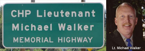 The portion of Rout 17 in Santa Cruz County south of Glenwood Road (SCR 5.91 to SCR 11.78) is
named the "Lieutenant Michael Elvin Walker Memorial Highway". This
segment was named in memory of CHP Lieutenant Michael Elvin Walker, Badge
No. 9919, who was born on September 19, 1959, in San Francisco. Lieutenant
Walker attended Archbishop Riordan High School in San Francisco, and later
attended Solano and Los Medanos Community Colleges, San Francisco City
College, and San Francisco State University. He and his brother wanted to
become CHP officers at an early age, and in October 1981, Lieutenant
Walker graduated from the CHP Academy, started his career in Los Angeles,
transferred after one year to his hometown of San Francisco, and then
transferred in 1983 to Contra Costa County where he remained for 15 years.
Lieutenant Walker was interested in pursuing a career in management,
worked at the CHP's Golden Gate Communications Center, was promoted to
sergeant, transferred to the Cordelia Inspection Facility in Solano
County, and was promoted in May 2005, to lieutenant with a position in
Santa Cruz. Lieutenant Walker was killed on December 31, 2005, while
assisting a disabled motorist traveling southbound on Route 17 just south
of Glenwood Drive in Santa Cruz County. The motorist had lost control on a
curve on the wet, mountainous roadway and was disabled on the highway
embankment, and as Lieutenant Walker retrieved flares from the trunk of
his patrol vehicle, another vehicle struck a Caltrans truck that had
responded to assist with traffic control, with the impact of the collision
forcing the Caltrans truck forward and fatally striking Lieutenant Walker.
The CHP provided more information in a FB memorium: Lt. Michael Walker (47) was struck and killed by a vehicle while at the scene of an earlier accident on Route 17 near Santa
Cruz. The previous accident occurred when a vehicle lost control on the
wet road surface and went into a ditch. Lieutenant Walker, his partner,
and a CalTrans employee had responded to the scene to investigate the
accident and to help free the vehicle from the ditch. As Lieutenant Walker
set out flares another vehicle lost control on the wet road surface and
struck the back of the CalTrans truck. The truck was pushed forward and
struck Lieutenant Walker. He was transported to a local hospital where he
succumbed to his injuries one hour later. A CalTrans employee was also
struck and seriously injured by the vehicle. The driver of the vehicle,
who was driving too fast for the wet conditions, was killed in the
accident. On May 30, 2008, exactly 27 years after Lt. Walker was called to
attend the CHP Academy, a section of Route 17 encompassing the accident
site was renamed "CHP Lt. Michael Walker Memorial Highway". Named by
Senate Concurrent Resolution (SCR) 51, Resolution Chapter 110, on
9/7/2007.
The portion of Rout 17 in Santa Cruz County south of Glenwood Road (SCR 5.91 to SCR 11.78) is
named the "Lieutenant Michael Elvin Walker Memorial Highway". This
segment was named in memory of CHP Lieutenant Michael Elvin Walker, Badge
No. 9919, who was born on September 19, 1959, in San Francisco. Lieutenant
Walker attended Archbishop Riordan High School in San Francisco, and later
attended Solano and Los Medanos Community Colleges, San Francisco City
College, and San Francisco State University. He and his brother wanted to
become CHP officers at an early age, and in October 1981, Lieutenant
Walker graduated from the CHP Academy, started his career in Los Angeles,
transferred after one year to his hometown of San Francisco, and then
transferred in 1983 to Contra Costa County where he remained for 15 years.
Lieutenant Walker was interested in pursuing a career in management,
worked at the CHP's Golden Gate Communications Center, was promoted to
sergeant, transferred to the Cordelia Inspection Facility in Solano
County, and was promoted in May 2005, to lieutenant with a position in
Santa Cruz. Lieutenant Walker was killed on December 31, 2005, while
assisting a disabled motorist traveling southbound on Route 17 just south
of Glenwood Drive in Santa Cruz County. The motorist had lost control on a
curve on the wet, mountainous roadway and was disabled on the highway
embankment, and as Lieutenant Walker retrieved flares from the trunk of
his patrol vehicle, another vehicle struck a Caltrans truck that had
responded to assist with traffic control, with the impact of the collision
forcing the Caltrans truck forward and fatally striking Lieutenant Walker.
The CHP provided more information in a FB memorium: Lt. Michael Walker (47) was struck and killed by a vehicle while at the scene of an earlier accident on Route 17 near Santa
Cruz. The previous accident occurred when a vehicle lost control on the
wet road surface and went into a ditch. Lieutenant Walker, his partner,
and a CalTrans employee had responded to the scene to investigate the
accident and to help free the vehicle from the ditch. As Lieutenant Walker
set out flares another vehicle lost control on the wet road surface and
struck the back of the CalTrans truck. The truck was pushed forward and
struck Lieutenant Walker. He was transported to a local hospital where he
succumbed to his injuries one hour later. A CalTrans employee was also
struck and seriously injured by the vehicle. The driver of the vehicle,
who was driving too fast for the wet conditions, was killed in the
accident. On May 30, 2008, exactly 27 years after Lt. Walker was called to
attend the CHP Academy, a section of Route 17 encompassing the accident
site was renamed "CHP Lt. Michael Walker Memorial Highway". Named by
Senate Concurrent Resolution (SCR) 51, Resolution Chapter 110, on
9/7/2007.
(Image sources: Waymarking; CHP Memorial Page)
The largest curve on Route 17 over the Santa Cruz Mountains is named the "Big Moody Curve" (~ SCL 1.888). It is halfway between the summit (Santa Cruz/Santa Clara County line) and the Alma Fire Station at the Lexington Reservoir near Los Gatos. Moody Creek runs beneath the road.
 Named Structures
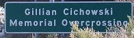 The bridge over Route 17 near Los Gatos at Lexington Reservoir is named the "Gillian
Cichowski Memorial Overcrossing Bridge" (Business Route 37-0565, SCL 004.30). It
was named by Senate Concurrent Resolution 32, Chapter 70 in 1994. Gillian
Cichowski, teacher, active community leader and mother of two children,
was killed in February, 1992, while attempting to make a left turn on
Route 17 near the Lexington Reservoir. Her death gave impetus to the
building of the overpass that replaced the left turn at that intersection.
This is one of the few highway constructions in California named for a
woman. The overpass was in response to a campaign by friends of Gillian
Cichowski to make the intersection (with Bear Creek Road) safer. Gillian
Cichowski (nee Casson) was an Englishwoman who had married an American
and, having settled to bring up a family in the Los Gatos area, had become
very active and involved in the local community. She was much respected as
President of the Parents' and Teachers' Association at Lexington School,
and the naming of the overpass for which she had previously been a
campaigner, was a great tribute to her memory The overpass was open to
northbound traffic July 18, 1996 and opened to southbound traffic August
29, 1996.
The bridge over Route 17 near Los Gatos at Lexington Reservoir is named the "Gillian
Cichowski Memorial Overcrossing Bridge" (Business Route 37-0565, SCL 004.30). It
was named by Senate Concurrent Resolution 32, Chapter 70 in 1994. Gillian
Cichowski, teacher, active community leader and mother of two children,
was killed in February, 1992, while attempting to make a left turn on
Route 17 near the Lexington Reservoir. Her death gave impetus to the
building of the overpass that replaced the left turn at that intersection.
This is one of the few highway constructions in California named for a
woman. The overpass was in response to a campaign by friends of Gillian
Cichowski to make the intersection (with Bear Creek Road) safer. Gillian
Cichowski (nee Casson) was an Englishwoman who had married an American
and, having settled to bring up a family in the Los Gatos area, had become
very active and involved in the local community. She was much respected as
President of the Parents' and Teachers' Association at Lexington School,
and the naming of the overpass for which she had previously been a
campaigner, was a great tribute to her memory The overpass was open to
northbound traffic July 18, 1996 and opened to southbound traffic August
29, 1996.
(Additional information: Localwiki; Image source: Localwiki)
 Exit Information
 Other WWW Links
 Scenic Route
 Classified Landcaped Freeway
The following segments are designated as Classified Landscaped Freeway:
| County | Route | Starting PM | Ending PM |
| Santa Cruz | 17 | 0.00 | 0.30 |
| Santa Cruz | 17 | 0.56 | 0.82 |
| Santa Cruz | 17 | 3.21 | 3.48 |
| Santa Clara | 17 | 6.07 | 13.95 |
 Freeway
[SHC 253.2] From Route 1 near Santa Cruz to Granite Creek Road near Scott' s Valley; and from the south city limits of Los Gatos to Route 280 in San Jose. The entire route was named as part of the Freeway and Expressway system in 1959; the portion from Granite Creek Road to Los Gatos was deleted from the Freeway and Expressway system in 1973 by Chapter 882.
According to John David Galt, Route 17 is constructed as a freeway from
at I-280 (where I-880 ends and becomes Route 17) to southern Los Gatos,
where the first intersection is a dead-end road leading to "The Cats"
restaurant. From there, most of the way over the hill, it's not a freeway;
however, there are three interchanges on this non-freeway section: Bear
Creek Rd., Redwood Estates, and Summit Rd. (unsigned Route 35). The
freeway resumes at the Granite Creek Rd. exit (formerly Santa's Village
Road; the one-time amusement park is now an office complex), and from
there to Route 1, it's a freeway (although no longer part of the freeway
and expressway system), except for a short stretch around one
intersection.
(Source: Information in this paragraph was adapted
from a post by Mr. Galt on m.t.r.)
 Statistics
Overall statistics for Route 17:
 Interregional Route
[SHC 164.11] Between the north urban limits of Santa Cruz and the south urban limits of San Jose.
 Pre-1964 Legislative Route
The route that would become LRN 17 was first defined in the 1909 First Bond Act as running from Roseville to Nevada City. It remained unchanged, as was codified in the 1935 codes as:
317. [LRN 17] is from Roseville to Nevada City.
In 1957, Chapter 36 changed the origin from "Roseville" to "[LRN 3] S of Roseville", making the definition: "From [LRN 3] S of Roseville to Nevada City."
LRN 3 was the US 40/US 99E junction. From the junction, US 99E (LRN 3; now Route 65) ran N, and US 40 (LRN 17; now I-80) ran NE. At Auburn, LRN 17 split off US 40 and continued N as Route 49. It ran signed as Route 49 N to Route 20 (LRN 15) near Nevada City.
© 1996-2020 Daniel P. Faigin.
Maintained by: Daniel P. Faigin
<webmaster@cahighways.org>.
 From Route
  Route 16
 Route 18