
 California Highways:
Click here for a key to the symbols used. An explanation of acronyms may be found at the bottom of the page.
 Routing
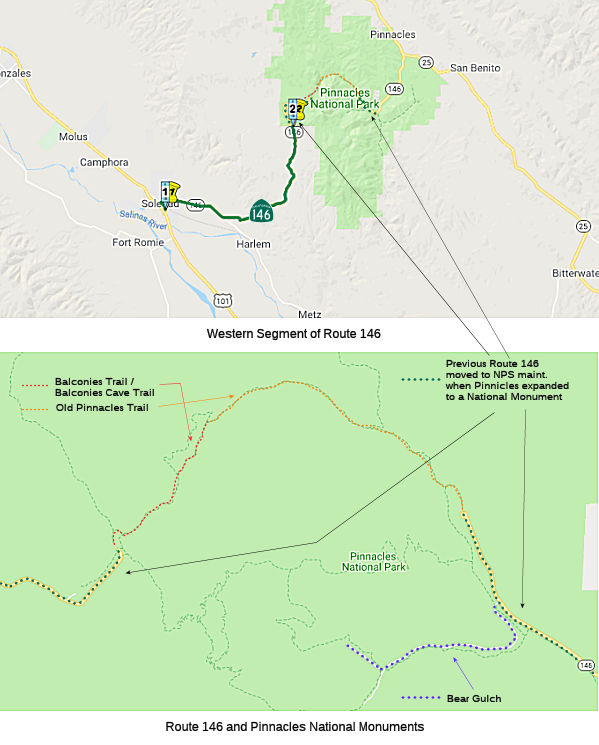 From Route 101 near Soledad to Pinnacles National Monument.
 Post 1964 Signage History
This segment is as defined in 1963.
In 2009, AB 344 (Chapter 238, 10/11/2009) authorized relinquishment of the portion in Soledad by adding:
(b) (1) Notwithstanding subdivision (a), the commission may relinquish to the City of Soledad the portion of Route 146 within the city limits of that city, upon terms and conditions the commission finds to be in the best interests of the state.
(2) Notwithstanding subdivision (a), the commission may relinquish to the County of Monterey the portion of Route 146 within the limits of that county, upon terms and conditions the commission finds to be in the best interests of the state.
(3) Notwithstanding subdivision (a), the commission may relinquish to the County of San Benito the portion of Route 146 within the limits of that county, upon terms and conditions the commission finds to be in the best interests of the state.
(4) A relinquishment under this subdivision shall become effective immediately after the county recorder records the relinquishment resolution that contains the commission's approval of the terms and conditions of the relinquishment.
(5) On and after the effective date of the relinquishment, that portion of Route 146 relinquished shall cease to be a state highway and may not be considered for future adoption under Section 81.
(6) For portions of Route 146 relinquished under this subdivision, the City of Soledad and the Counties of Monterey and San Benito shall maintain within their jurisdiction signs directing motorists to the continuation of Route 146 until the entire route has been relinquished.
This portion of the route in Soledad was relinquished in September 2010.
In 2012, AB 2679 (Chapter 769, 9/29/2012) updated the wording to reflect the relinquishment in Soledad:
(b)
(1)TheNotwithstanding subdivision (a), the commission may relinquish to the City of Soledad therelinquished former portion of Route 146 within thecity limits of that city, upon terms and conditions the commission finds to be in the best interests of the state.City of Soledad is not a state highway and is not eligible for adoption under Section 81. For the relinquished former portion of Route 146, the City of Soledad shall maintain within its jurisdiction signs directing motorists to the continuation of Route 146 until the entire route has been relinquished and shall ensure the continuity of traffic flow on the relinquished portion of Route 146, including any traffic signal progression.
(2)(1) Notwithstanding subdivision (a), the commission may relinquish to the County of Monterey the portion of Route 146 within the limits of that county, upon terms and conditions the commission finds to be in the best interests of the state.
(3)(2) Notwithstanding subdivision (a), the commission may relinquish to the County of San Benito the portion of Route 146 within the limits of that county, upon terms and conditions the commission finds to be in the best interests of the state.
(4)(3) A relinquishment under this subdivision shall become effective immediately after the county recorder records the relinquishment resolution that contains the commission’s approval of the terms and conditions of the relinquishment.
(5)(4) On and after the effective date of the relinquishment, that portion of Route 146 relinquished shall cease to be a state highway and may not be considered for future adoption under Section 81.
(6)(5) For portions of Route 146 relinquished under this subdivision, theCity of Soledad andthe Counties of Monterey and San Benito shall maintain within their jurisdiction signs directing motorists to the continuation of Route 146 until the entire route has been relinquished.
 Pre 1964 Signage History
This entire route was LRN 120, defined in 1933. It was not signed before 1964.
The original western alignment of the road to West Pinnacles took
Stonewall Canyon Road to modern Route 146. That alignment was replaced
sometime between 1940 and 1942 (as shown on the indicated state highway maps)
(Source: Tom Fearer (Max Rockatansky) on AARoads, 11/28/2016)
Signed Route 146 was not defined as part of the initial state signage of routes in 1934. It is unclear what (if any) route was signed as Route 146 between 1934 and 1964.
 Status
Near Soledad, this route seems to run along Business Route 101 and Broadway.
In September 2010, the CTC approved relinquishment of right of way in the city of Soledad on Route 146, from the city limits at Route 101 to the city limits at Tiburon Street. Authorized by Chapter 238, Statutes of 2009, which amended Section 446 of the Streets and Highways Code.
In December 2017, the TAMC RTIP noted the following project from the City
of Soledad: Route 146 Bypass: This City of Soledad
project will realign Route146 and construct a new two‐lane arterial
around the south edge of Soledad, connecting the South Soledad interchange
with Metz Road with a crossing of the Union Pacific Railroad tracks. This
facility will serve interregional traffic traveling to the Pinnacles
National Park.
(Source: TAMC RTIP Final Package, 12/2017)
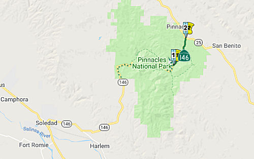 From Pinnacles National Monument to Route 25 in Bear Valley.
Post 1964 Signage HistoryThis segment is as defined in 1963.
In October 2018, it was noted that almost all Route 146 signage,
including junction markers and postmiles, is gone from the eastern Route 146 segment and its junction with Route 25. All that remains is a callbox
at the Route 25 junction, with a sign indicating that it was on Route 146.
The old East Entrance station has disappeared along with the End Route 146
sign; there's only a wide spot in the road where the station was located.
The National Park Service is considering a replacement east entrance
station. Its preferred alternative would be to put the new station
immediately west of the Route 25 junction. That would put it closer to the
expanded park boundary, and also give the park a chance to hit up visitors
for the entrance fee before they reach the visitor center, or any
campgrounds or other park facilities.
(Source: Oscar Voss on AAroads, "Re: CA 146 East", 1/5/2019)
In January 2020, it was confirmed that the Route 146 signage on the
Eastern segment of the route has been removed.
(Source: Tom Fearer (Max Rockatansky) on AARoad, "Re: CA 146 East", 1/24/2020)
Pre 1964 Signage HistoryThis entire route was LRN 120, defined in 1933. It was not signed before 1964.
A 1934 Division of Highways Map shows the eastern segment of LRN 120
(Route 146) running west from Route 25 into Pinnacles National Monument
past the current terminus about a mile to Bear Gulch. The Bear Gulch Road
is pretty much a straight to the western LRN 120 (Route 146) which makes
it likely that this is what the post number gap is based off of. That
means,if the map is correct, there was for a time a less than 2 mile gap
between both segments of LRN 120 (Route 146). The state maps are too
zoomed out really to provide any insight onto when the eastern segment of
Route 120 might have been pulled back to the boundary with Pinnacles
National Monument where the current Route 146 terminus is located. Route 146 in East Pinnacles still retains the same length that it had when it was a National Monument; this is because when the Monument was
expanded to a Park, the boundary was expanded. That left Route 146 East
maintained by Caltrans within the new National Park Boundary. From the
west on Route 146 the highway segment is only 2.45 miles. Despite no
reassurance markers westbound there is a Route 146 END sign at the former
boundary for Pinnacles National Monument. The Eastern Segment of Route 146
has mileage markers ranging from 12.70 to 15.15. Essentially it is a
straight line from the terminus of the western segment across the
Pinnacles which ends at 10.19.
(Source: Tom Fearer (Max Rockatansky) in AARoads discussion on 146, June 2017)
Route 146 was not defined as part of the initial state signage of routes in 1934. It is unclear what (if any) route was signed as Route 146 between 1934 and 1964.
StatusNote that the two segments of this route are not contiguous; this is made clear in the National Park Service Map for Pinnacles National Monument. They are connected by the Old Pinnacles Trail.
 Scenic Route
[SHC 263.7] Entire portion.
 Interregional Route
[SHC 164.17] Between Route 101 and Pinnacles National Monument.
 Other WWW Links
 Statistics
Overall statistics for Route 146:
 Pre-1964 Legislative Route
In 1933, Chapter 767 added the following routes to the highway system:
In 1935, LRN 146 was added to the highway code with the following routings:
In 1959, Chapter 1062 changed the origin of (a): "County Line
near Palo Verde [LRN 187] east of Brawley to …"
In 1961, Chapter 1387 allowed construction to begin earlier: “Notwithstanding the provisions of Section 89 of Chapter 1062, Statutes of 1959, the department shall proceed with the construction of the unconstructed portion of said route described in subdivision (a) between the junction of [LRN 187] and the Imperial-Riverside county line with the lowest practical cost for a hard surfaced road and as an interim project pending the later construction of the route to proper limited access standards; provided that prior thereto the County of Imperial enters into a co-operative agreement with the department wherein the county agrees to maintain the road between the junction of [LRN 187] and the Imperial-Riverside County Line until a limited access highway is constructed by the department between said points. Upon the completion of construction of said interim road and pursuant to said agreement, the county shall assume jurisdiction and all responsibilities of maintenance for the period above provided. The road shall be known and designed as the "Ben Hulse Highway"”
This route was signed as follows:
This is present-day Route 78, some of which is unconstructed. Before 1964, the portion between Route 86 and Palo Verde was a proposed routing, and the remainder was part of US 95 (originally Route 195). The US 95 portion as defined in 1933; the remainder was defined in 1959. The portion between Palo Verde was Blythe was originally signed as Route 195 until US 95 was signed in 1940; at that point, although under state maintenance, it appears to have been unsigned. The portion between Brawley and Palo Verde was defined in 1959, and between 1961 and the construction of current Route 78, was signed as County Sign Route S78.
This is US 95, defined in 1940. It was previously signed as Route 195.
This is US 95, defined in 1940. It was previously signed as Route 195.
© 1996-2020 Daniel P. Faigin.
Maintained by: Daniel P. Faigin
<webmaster@cahighways.org>.
 Route 145
 Route 147