
 California Highways:
Click here for a key to the symbols used. An explanation of acronyms may be found at the bottom of the page.
 Routing
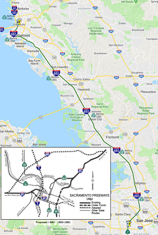 (a) From Route 280 in San Jose to Route 80 in Oakland.
(b) (1) The commission may relinquish to the City of Oakland the portion of the former right-of-way of Route 880 that is located between 8ᵗʰ Street and 32ⁿᵈ Street within that city, upon terms and conditions the commission finds to be in the best interests of the state, including, but not limited to, a requirement that the department and the city enter into a cooperative agreement to improve, at the department's expense, the two parallel adjacent city streets, including, but not limited to, sidewalks, landscaping, and street lighting, when improving the portion of right-of-way that is to be relinquished in accordance with plans to be developed by the department. The cooperative agreement shall include, but need not to be limited to, all of the following: (A) A requirement that, if the commission allocates funds for this purpose, the improvements include bicycle paths and the associated roadway improvements and landscaping, including a bicycle path that closes the gap in the San Francisco Bay Trail Plan. (B) A requirement that the improvements include removal of contaminated materials on the department's property. (C) A requirement that the improvements include erection of a memorial to the victims of the collapse of the Cypress Freeway Viaduct and to the heroism of those who responded to that disaster. (2) A relinquishment under this subdivision shall become effective immediately following the commission's approval of the terms and conditions of the relinquishment.
 Post 1964 Signage History
In 1963, I-880 was defined as "Route 80 between Harbor Boulevard and the Yolo Causeway west of Sacramento to Route 80 near Watt Avenue."
In 1981, Chapter 292 transferred that version of I-880 to I-80. See Route 80 for a history of the Sacramento Bypass, as well as the pages on US 50 and I-305.
In 1984, Chapter 409 defined I-880 by transfer from Route 17: "Route 280 in San Jose to Route 80 in Oakland." It appears that the current routing was originally to have been designated as I-280/I-680 (at least in the San Jose area). See Route 17 or I-680 for details.
The Cypress Freeway Alignment in Oakland
For decades after the Cypress Freeway was completed in 1957, it served as a magnet for community frustration among West Oakland residents. Residents argued they were given no opportunities to participate in the planning and design process and many blamed the freeway for Oakland's decline that began during the 1960s. According to one former West Oakland resident, "Cypress opened the door. It really split the city physically. It was the beginning of the end. It ruined the integrity of the whole area."
In 1989, the double-decked portion of the route,
between 18ᵗʰ Street and 34ᵗʰ Street in Oakland,
collapsed in the Loma Prieta earthquake. After the earthquake, Caltrans
initially proposed to rebuild the Cypress in its existing location. This
plan, however, was adamantly opposed by the City of Oakland, Alameda
County officials, Citizens Emergency Relief Team (CERT), and the vast
majority of the West Oakland community. Meanwhile, members of CERT,
together with city and county officials, had begun efforts to identify an
alternative route for the Cypress. This alignment would run west of the
previous Cypress structure closer to the Port of Oakland, following
Southern Pacific railroad tracks for a portion of the way. The new route
would still impact a small residential area. However, the majority of West
Oakland would be reunited under this plan. Debate over the alignment for
the reconstruction of the Cypress Freeway continued for eighteen months.
During this period, Caltrans helped form the Community Advisory Committee
(CAC), comprised of West Oakland citizens, and participated in scores of
meetings with the CAC, CERT, the West Oakland Commerce Association, City
of Oakland officials, and commuter groups. The coalition backing a new
alignment for the freeway frequently used the language and symbolism of
environmental justice to articulate its positions. As one frustrated West
Oakland resident asked, "How about putting the freeway through Blackhawk
or Danville? Why is the poor community always having to pay?" Residents
argued that car exhaust fumes contributed to higher incidences of
underweight babies, infant deaths, and acute and chronic diseases in West
Oakland than elsewhere in Alameda County, a claim supported by health
officials. The discussion over the future Cypress freeway alignment was
complicated from the start because, at the outset, Caltrans and the
community of West Oakland held very different perspectives on the project.
For Caltrans, it was above all a transportation project of regional
importance, necessary to replace an essential link in the East Bay's
freeway network. For others, however, particularly CERT and its allies, it
was principally a community revitalization project that had the potential
to help return West Oakland to its previous grandeur and address
environmental justice concerns of community residents. Although Caltrans
never wavered in its commitment to restoring the Cypress as a regionally
significant highway connector, dialogue with the West Oakland community
ultimately sensitized the agency to the community's perspective as well.
For twelve months following the Loma Prieta earthquake, Caltrans worked to
prepare a Draft Environmental Impact Statement (EIS), evaluating numerous
alternatives for responding to the collapse of the Cypress Freeway. Six
alternatives were identified in the Draft EIS released by Caltrans in
November 1990. These included a no-build alternative, two alternatives
that would utilize the existing Cypress right-of-way, and three versions
of the railroad corridor alignment advocated by CERT and the City of
Oakland. Eight months after the official public comment period for the
Draft EIS ended on February 1, 1991, Caltrans released the Final EIS for
the Cypress Freeway Replacement Project, which identified the selected
alignment for the new freeway. Responding to pressure from the City of
Oakland and West Oakland citizens, Caltrans selected the
Transit/TSM/Freeway Alternative in the Railroad Corridor, which redirected
the freeway along railroad tracks to the west of the community. This
alternative added over one mile to the freeway at a cost of more than $500
million for purchase of the right-of-way alone. However, it represented an
opportunity to reunite West Oakland, a crucial step in addressing the
social and economic problems of this community. Negotiations among
Caltrans, the City of Oakland, and West Oakland community groups over the
project design led to a number of additional community benefits. First,
Caltrans agreed to provide a direct off-ramp from the new freeway to
service the Port of Oakland, meaning that heavy transport trucks traveling
to and from the Port would no longer traverse residential neighborhood
streets. This interchange, valued at nearly $25 million, was also expected
to improve the Port's competitive position vis-à-vis other West Coast
ports and facilitate employment opportunities for local residents. In
addition, although Caltrans initially proposed to eliminate an existing
off-ramp at Market Street, West Oakland businesses and community groups
expressed concern that this might limit access to local businesses. A West
Oakland resident and member of CERT who was also chief of construction for
Alameda County prepared a design to maintain the interchange which was
presented to Caltrans at community meetings. Largely on the basis of this
proposal, Caltrans agreed to modify and retrofit the existing structure at
Market Street. During construction, Caltrans also made efforts to ensure
that Oakland residents and businesses benefited from the project. During
the demolition phase, Caltrans archaeologists excavated sites along the
route and uncovered a wealth of artifacts dating back to the 1800s. Key
finds included turn-of-the-century artifacts belonging to African-American
railroad porters. While fieldwork was in progress, oral history interviews
with former porters were carried out to gather information on how jobs
were done and what they meant to the workers. Caltrans compiled artifacts,
historic photographs, and documentation into a traveling exhibit called
"Holding the Fort: An Exhibit of African-American Historical Archaeology
and Labor History in West Oakland." The title of the exhibit comes from a
song regularly sung by the Brotherhood of Sleeping Car Porters at their
West Oakland meetings.
(Source: FHWA Environmental Justice Case Study)
Between 1989 and 1997, thru-traffic used a routing starting at I-980, and along I-980 to I-580, and along I-580 to I-80 in Oakland.
The replacement routing, which opened in 1997 and 1998,
was constructed closer to the bay along the Southern Pacific tracks. The
road is six lanes from I-980 to a modified Grand Avenue interchange, where
two-lane flyovers connect to the Bay Bridge I-80 approaches and two other
flyovers connect to I-80/I-580 going north, completely avoiding the
I-80/I-580 interchange. The replacement section was 5 miles long, and cost
$1.25 billion to build.
(Source: Scott "Kurumi" Oglesby for much of this information)
In 2000, the portion of the former right-of-way of Route 880 that is located between 8ᵗʰ Street and 32ⁿᵈ Street within the City of Oakland was relinquished to the City of Oakland, providing that certain improvements were made, such as including bicycle paths and the associated roadway improvements and landscaping (including a bicycle path that closes the gap in the San Francisco Bay Trail Plan); removal of contaminated materials; and erection of a memorial to the victims of the collapse of the Cypress Freeway Viaduct and to the heroism of those who responded to that disaster. The relinquishment was authorized by Senate Bill 1645, Chapter 538, on September 19, 2000. On the June 2002 CTC agenda, 04-Ala-880-PM 25.5/26.1 in the City of Oakland was up for relinquishement. That is probably the segment in question. The memorial was discussed on the November 2002 CTC agenda. It would be on Mandela Parkway between 13ᵗʰ and 14ᵗʰ Streets in West Oakland, be 44,750 Ft², and include a sculpture, an historic plaque, a water fountain and benches, with $250K coming from Caltrans, and $614,800 from other sources. The Mandela Parkway Improvement Project will include modifying the roadway to be straighter and more consistent; widening of some side streets to permit two-way traffic; updating traffic signals and poles to provide the appearance of a gateway; addition of a Bay Trail alignment on each side of Mandela Parkway; including a 10-foot-wide meandering concrete pathway in the median; decorative landscaping and lighting, including labelng of trees from all over the world.
 Pre 1964 Signage History
See Route 80 for information on the pre-1981 routing of what was to be signed I-880.
The post-1984 routing was originally signed as Route 13 in 1934, and was later resigned as Route 17. See Route 17 for a lot of the details on the past routing. In Oakland, it ran along Cypress Street; according to the CalTrans Photolog in 2001, the Cypress Street routing was still state-maintained. For a time, it was signed as US101E. In 1986, it was resigned again as I-880. At I-280 (as of 1963 unbuilt, but LRN 239 (defined in 1959) to the W and LRN 5 (defined in 1909) to the E), I-880 was LRN 239 (still signed as Route 17), and continued N to the junction with Bypass US 101 (LRN 68; present-day US 101). Before LRN 239 was defined, it was likely that Route 17 (present-day I-880) was LRN 5. Construction on what is now I-880 began in 1946; it was completed in 1960. Based on a 1942 map, the current I-880/I-580 interchange (back then, the Route 17, US 50, US 40, and BR US 50 interchange) was constructed in the early 1940s.
 In 1952, the CHC adopted a routing for the Eastshore Freeway routing of Route 17. The routing starts
from Sign Route 9 (now I-680) just N of its junction with Sign Route 17
(I-880) near Warm Springs, and runs SE joining the proposed Eastshore
Freeway near Railroad Avenue.
In 1952, the CHC adopted a routing for the Eastshore Freeway routing of Route 17. The routing starts
from Sign Route 9 (now I-680) just N of its junction with Sign Route 17
(I-880) near Warm Springs, and runs SE joining the proposed Eastshore
Freeway near Railroad Avenue.
(Source: Palo Alto Times, 1/17/1952 via Joel Windmiller, 2/13/2023)
I-880 (as Route 17) then continued N along present I-880, and was LRN 69 (defined in 1933) until its junction near Emeryville with US 40/US 50 (LRN 68 and LRN 5; present-day I-80 and I-580). Some portions in Oakland were LRN 105. The original definition of Route 17 continued N along what is now I-580/I-80, and then across the bay as I-580.
 Status
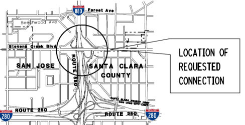
Valley Fair / Stevens Creek Blvd / I-280 I-880 Route 17 Interchange (~ SCL 0.062)
According to the Mercury News, there are plans for a major overhaul of the I-280/I-880 interchange, that will cost at least $109,000,000 and won't commence until at least 2011. The original plan was to simply redesign the ramp from north I-280 to north I-880 and Stevens Creek Boulevard, including redesigning the exits from Route 17 and I-280 onto Stevens Creek and north I-880, where drivers must now merge into a single lane, creating backups on I-280 and I-880 that extend for miles. However, it turned out that the primary problem is the intersection at Monroe Street and Stevens Creek, the first entrance into Westfield Valley Fair, where one in three cars coming off I-880 is headed. Cars exiting from south I-880 must jam onto Stevens Creek before they reach Monroe; planners realized that until this problem is addressed, other fixes will do little good. So a more comprehensive plan was developed that includes:
Note that about 85% of traffic from north I-280 is headed to Stevens Creek, while 15% is going to I-880 on weekends and during the afternoon commute. During the early hours of the weekday morning commute, three out of five vehicles are going toward Stevens Creek compared to I-880, changing to an 80/20 split by 10:00 am.
A later report on the construction in January 2009 noted that construction could be under way in 2010, and, at about $150 million, the price tag will top the $135 million spent to rebuild the Route 85/US 101 interchange in Mountain View, the previous Northern California record for such work. Gone will be the many cloverleaf ramps and dangerous merges, replaced by longer exit lanes, much wider ramps and a wider Stevens Creek Boulevard. The issue is the source of funding. About $21 million is in hand as of January 2009, enough to complete the first phase from south I-880 onto Stevens Creek. State and federal highway funds, future bond money and some federal stimulus dollars also could also be earmarked for this project.
In June 2009, the CTC received notice of the preparation of the EIR for the I-280/I-880/Route 17 interchange project. The project will modify the Route 17/Interstate 280/Interstate 880 freeway, as well as two adjacent interchanges at Interstate 880/Stevens Creek Boulevard and Interstate 280/Winchester Boulevard. The project is not fully funded. Likely funding sources include federal earmark, as well as local funding from the City of San Jose and the Santa Clara Valley Transportation Agency. The total cost of the project is estimated between $130,000,000 and $150,000,000. Assuming the availability of funding, construction is estimated to begin in Fiscal Year 2010-11.
 In June 2010, the CTC approved $30,975,000 in CMIA
funding to reconfigure the eastern half of the I-880/Stevens Creek
Boulevard interchange and construct a northbound I-280 to northbound I-880
direct connector ramp. During the development of the project, it was
determined that an expanded scope would provide more efficient traffic
operations. Consequently, in March 2012, the Commission approved an
additional $10,300,000 in CMIA funding in order to fully fund the expanded
scope on the project. In May 2012, the CTC approved changing the scope to
include reconfiguring the western half of I-880/Stevens Creek Boulevard
interchange and improving the southbound I-880 on and off ramps at Stevens
Creek Boulevard, including a dedicated off-ramp to Monroe Street. They
also approved a new public road connection to I-880 at North Monroe Street
in the city of San Jose, at Post Mile 0.4. This is part of the project to
construct a dedicated lane directly onto Monroe Street from the realigned
Southbound I-880/Stevens Creek Boulevard exit-ramp. The dedicated lane to
Monroe Street will have an 18-foot-wide lane with 4-foot-wide left and
8-foot-wide right shoulders. This project would reconfigure a portion of
Monroe Street, approximately 400 feet north of the intersection with
Stevens Creek Boulevard, to accommodate the dedicated lane from the
southbound I-880 exit ramp. In order to accommodate realigning the exit
ramp and to terminate it onto Monroe Street, additional Right of Way will
be required. This will also require a new access point along the existing
controlled access right of way.
In June 2010, the CTC approved $30,975,000 in CMIA
funding to reconfigure the eastern half of the I-880/Stevens Creek
Boulevard interchange and construct a northbound I-280 to northbound I-880
direct connector ramp. During the development of the project, it was
determined that an expanded scope would provide more efficient traffic
operations. Consequently, in March 2012, the Commission approved an
additional $10,300,000 in CMIA funding in order to fully fund the expanded
scope on the project. In May 2012, the CTC approved changing the scope to
include reconfiguring the western half of I-880/Stevens Creek Boulevard
interchange and improving the southbound I-880 on and off ramps at Stevens
Creek Boulevard, including a dedicated off-ramp to Monroe Street. They
also approved a new public road connection to I-880 at North Monroe Street
in the city of San Jose, at Post Mile 0.4. This is part of the project to
construct a dedicated lane directly onto Monroe Street from the realigned
Southbound I-880/Stevens Creek Boulevard exit-ramp. The dedicated lane to
Monroe Street will have an 18-foot-wide lane with 4-foot-wide left and
8-foot-wide right shoulders. This project would reconfigure a portion of
Monroe Street, approximately 400 feet north of the intersection with
Stevens Creek Boulevard, to accommodate the dedicated lane from the
southbound I-880 exit ramp. In order to accommodate realigning the exit
ramp and to terminate it onto Monroe Street, additional Right of Way will
be required. This will also require a new access point along the existing
controlled access right of way.
Scheduled for Spring 2011 is the repaving of I-880 from I-280 next to the Valley Fair shopping center to US 101 through San Jose
In October 2011, the CTC approved for future consideration of funding a project to construct improvements at the Route 17/I-280/I-880 Interchange and I-880/Stevens Creek Boulevard Interchange. The project will be done in phases. Phase 1 will construct northbound I-280 to NB I-880 direct connector, reconfigure northbound I-880/Stevens Creek Boulevard Interchange quadrant, widen I-880/Stevens Creek Boulevard Overcrossing and construct soundwall along Parkmoor Avenue. Phase 2 will reconfigure southbound I-880/Stevens Creek Boulevard Interchange quadrant, construct Monroe Street dedicated lane and construct soundwall along S. Daniel Way. Phase 1 can proceed without Phase 2. Phase 1 is programmed in the Corridor Mobility Improvement Account and includes local funds. The total estimated cost of Phase 1 is $54,400,000, capital and support. Phase 2 is not currently programmed. The total estimated cost of Phase 2 is $10,200,000, capital and support. Construction is estimated to begin in Fiscal Year 2012-13. The scope as described for the preferred alternative is consistent with the project scope set forth in the proposed project baseline agreement. A copy of the FEIR has been provided to Commission staff. Resources that may be impacted by the project include; noise, hazardous waste, biological resources, visual and aesthetics, water quality and stormwater runoff, and traffic. Potential impacts associated with the project can all be mitigated to below significance through proposed mitigation measures. As a result, a Final Environmental Impact Report was prepared for the project.
In September 2014, it was reported that construction
was nearly complete on the I-280/I-880 interchange project. In September,
three new on- and offramps to Stevens Creek Boulevard opened, and by
Thanksgiving 2014 a special lane feeding traffic onto Monroe Street and
bypassing Stevens Creek Boulevard was anticipated to be ready. Motorists
driving south on I-880 will use a new signalized offramp to turn onto
Stevens Creek. There will be three lanes turning right toward Valley Fair
and Santana Row and one lane turning left toward downtown San Jose.
Drivers on Stevens Creek headed to southbound Route 17 and southbound
I-280 will use a new onramp located closer to the freeway than the current
one. Motorists traveling to Stevens Creek from northbound Route 17 and
northbound I-280 will see a new signalized intersection. Traffic from
these ramps will no longer cross underneath the Stevens Creek Bridge and
loop onto the busy street. Instead, they will make a left-hand turn
through a new intersection with traffic lights. Of the $62.1 million cost,
$39.2 million came from state bonds approved by voters in 2006. The
federal government chipped in $19 million, and the remainder came from
local tax dollars. The reconstruction is a scaled-back version of what had
been planned. There will be no exit from north I-280 onto Winchester
Boulevard to allow for a back way into Santana Row, as VTA wanted, nor
will there be a second lane for traffic going south on I-880 to reach
north I-280. All that would have run the cost up to $150 million, and
Caltrans feared that this ramp would be too close to the new interchange
and create more problems than it would ease.
(Source: SJ Mercury News, 9/28/2014)
The San Jose Mercury News has received reports of
problems with the new I-280/I-880 interchange. There are reports of poorly
marked embankments, missing reflectors, and badly marked transitions.
There have been numerous accidents or near accidents. Caltrans is looking
at what can be done to make the interchange safer, as too many drivers
have reported near-rollovers.
(Source: SJ Mercury News, 3/21/2016; 4/5/2016)
The SAFETEA-LU act, enacted in August 2005 as the reauthorization of TEA-21, provided the following expenditures on or near this route:
Coleman Ave Interchange
There are also plans to reconstruct the Coleman Avenue interchange near the San Jose Airport (~ SCL 2.66). This is TCRP Project #8, requested by the Santa Clara Valley Transportation Authority. This was completed in 2004.
The SAFETEA-LU act, enacted in August 2005 as the reauthorization of TEA-21, provided the following expenditures on or near this route:
I-880 Widening between San Jose and Milpitas. (~ SCL 3.573 to SCL 6.657)
There were also plans to widen I-880 between the I-880/North First Street interchange in San Jose (S of US 101) to the Montague Expressway (Santa Clara County Sign Route G4, S of Route 237). This involved:
In 2007, the CTC considered a number of requests for funding from the Corridor Mobility Improvement Account (CMIA). Two requests were funded: the SB HOV Extension from Route 237 to US 101 ($71.6M) and the SB HOV lane from Marina to Hegenberger ($94.6M). A request to reconstruct the interchange with I-280 near Stevens Creek and Winchester ($50M) was not recommended for funding.
In September 2009, the CTC approved for future consideration of funding a project that will construct a high occupancy vehicle lane in each direction on Route 880 between Old Bayshore Highway in the city of San Jose and Route 237 in the city of Milpitas. The project is programmed in the Corridor Mobility Improvement Account and includes local funds. The total estimated project cost is $95,000,000, capital and support. Construction is estimated to begin in Fiscal Year 2010-11. The scope as described for the preferred alternative is consistent with the project scope set forth in the approved project baseline agreement.
In August 2011, the CTC approved funding $71,600,000 of state-administered CMIA funds for I-880 widening in the cities of San Jose and Milpitas, between US 101 and Route 237. This project would also construct HOV lanes in each direction.
In January 2012, the CTC approved reducing the original CMIA allocation for construction by $25,671,000 (reflecting construction contract award savings), from $61,790,000 to $36,119,000 from the I-880 Widening (Route 237 to US 101) project (PPNO 0415) in Santa Clara County. The contract was awarded on December 14, 2011.
In May 2012, it was reported that there are plans to widen I-880 from Route 237 almost to US 101, with major changes scheduled for the Brokaw Road interchange. A carpool lane will be added on the southbound onramp and the merge lane extended 700 feet. On the northbound side, the ramps will be shifted 70 feet east and there will be two lanes to turn left and two more to turn right. The tight, curvy two-lane ramp to north I-880 will be smoothed out. The cost is $68 million ($46 million from state bonds and $22 million from VTA); $15 million below engineers' estimates. Estimated completion is summer 2013.
In June 2013, it was reported that new carpool lanes have opened on a 4-mile stretch of I-880 from Route 237 in Milpitas to the US 101 interchange in San Jose. The $70-million project also added a carpool lane on the southbound onramp from Brokaw and extended the merge lane by 700 feet. Of that figure, $50 million comes from state bonds approved by voters and another $20 million from the Valley Transportation Authority's highway account. On the northbound side, the ramps have been shifted 70 feet east, and there are now two lanes to turn left and two more to turn right onto Brokaw. The tight, curvy two-lane ramp to north I-880 has been smoothed out.
Charcot Overcrossing (~ SCL 5.675)
In May 2019, it was reported that the Charcot
overcrossing of I-880 (~ SCL 5.675) in North San Jose will receive $37
million in the next few years. The Charcot bridge over I-880 could ease
traffic woes along Montague Expressway and Brokaw Road, which now serve as
the best ways to get onto I-880. There will be no ramps, so no merging
chaos of an interchange, and hopefully will provide a good connection for
people to walk and bike over the freeway, in addition to driving without
the stress of on- and off-ramps.
(Source: Mercury-News $$, 5/14/2019)
In February 2022, it was reported that the San Jose
City Council voted unanimously to drop a proposal to build the Charcot
Overpass. The overpass would have extended North San Jose’s Charcot
Avenue about .6 miles from Paragon Drive over I-880 to Oakland Road. Over
the past two years, parents and teachers of Orchard School on nearby Fox
Lane have launched petitions, attended dozens of community and city
meetings and even filed a lawsuit against the city to voice their disdain
for the project. Construction of the overpass would have required the city
to widen Silkwood Lane on the northern edge of the school’s campus
and invoke eminent domain to claim about a half-acre section of open space
on the school’s campus. Parents and teachers had argued that the
project would pose a safety risk to children walking to and from school,
increase pollution and shrink the school’s campus. In the works
since 1994, the Charcot Avenue extension project was integrated into the
city’s 2020 General Plan. City leaders at the time saw it as a
promising way to improve connectivity from the East and West sides of
I-880 and provide a crossing for not only vehicles, but bicycles and
pedestrians as well. It was also meant to support increased development
and economic vitality in industrial-heavy North San Jose. More recently,
San Jose has been locked in a legal battle with the city of Santa Clara
over development plans in the area. Santa Clara has repeatedly threatened
to sue San Jose if the city tried to add more housing in this
underutilized, largely industrial area of the city before making certain
transportation improvements. The Charcot Extension was previously
considered by the city of San Jose as one of those necessary
transportation improvements, aiming to relieve some of the congestion from
nearby Brokaw Road. Over the course of the past three decades, however,
the area around the proposed overpass has evolved considerably. Instead of
industrial buildings, the overpass would now be sandwiched between dozens
of new homes and Orchard Elementary School — neither of which
existed when the plans were first brought forward. On top of those
changes, Santa Clara city officials have indicated that the Charcot
Extension is not one of the priority traffic improvements they want to see
completed by the city of San Jose in North San Jose before more housing is
built, according to San Jose Mayor Sam Liccardo. Weighing those factors,
city officials decided that dropping the project and diverting the
remaining $3.9 million in project funds to two other high-priority traffic
improvement initiatives — the interchange project at US 101/Maybury/Berryessa or the interchange project at Highway 101 and Zanker
Road — was the best route to take.
(Source: Mercury News, 2/2/2022)
I-880 Express Lanes (~ SCL 6.775 to ALA 22.831)
In February 2013, it was reported that Caltrans plans to convert HOV lanes on I-880 into HOT ("Express" or High Occupancy/Toll) lanes -- specifically, I-880 between Highway 237 in Milpitas and south of Marina Boulevard in San Leandro (~ SCL 6.775 to ALA 22.831), and on the approaches from the freeway to the San Mateo and Dumbarton bridge toll plazas. Express lanes work by continuing to allow carpoolers free access to the fast lane but then selling unused capacity to drivers who wouldn't normally qualify to drive in them. Tolls are collected electronically using FasTrak transponders, and electronic systems are used to monitor traffic and set tolls at a rate designed to keep traffic in the lanes flowing at 50 mph or faster. As the lanes get more congested, tolls rise, and as gridlock eases, they drop. Toll rates for the network have not been set yet, but on the existing lanes they have varied from a 30-cent minimum to about $5 or $6.
In December 2019, it was reported that I-880 express
lanes are scheduled to open late summer 2020. The project cost is $139
million. The express lanes are intended primarily to improve traffic flow
for buses and carpools, which travel free in that lane, and to offer a
reliable commute for toll-paying drivers. Toll revenue is used to pay for
lane operations and maintenance, rather than to recoup construction costs.
Workers are converting to express lanes the existing I-880 HOV lanes that
run from Hegenberger Road in Oakland to Dixon Landing Road in Milpitas in
the southbound direction and from Dixon Landing Road to Lewelling
Boulevard in San Lorenzo in the northbound direction. The MTC, which is
the transportation planning, financing and coordinating agency for the
nine-county San Francisco Bay Area, said nearly all of the civil
construction work has been completed and ongoing work includes installing,
connecting and testing tolling equipment and connecting fiber cable for
future traffic monitoring in the corridor. The MTC said work near the
Hacienda overcrossing in San Leandro to improve drainage, finish the
retaining wall and complete paving on southbound I-880 is substantially
complete. The transportation agency said the toll system integration team
is working south to north in the corridor to install 29 overhead variable
toll-messaging signs known as VTMS and 12 of them have been installed so
far. Crews are continuing to install toll tag readers and pull cable for
data and power.
(Source: $ Mercury News, 12/13/2019; CBSNBay
Area, 12/31/2019)
In May 2020, it was reported that lane re-striping in
preparation for the Express Lanes was starting at the end of the month.
Striping changes in the southbound direction will start at Hegenberger
Road in Oakland and making their way to Dixon Landing Road near the Santa
Clara County line. Northbound, the changes will begin at Dixon Landing
Road and extend to Lewelling Blvd. in San Lorenzo. The new lane striping
will be painted between the far-left HOV lane (lane 1) and the adjacent
general-purpose lane (lane 2). Once the new striping is painted, drivers
in certain segments will not be allowed to move into or out of the
far-left lane. Lane-change rules will be effective immediately, even
though Express Lane tolling will not begin for several months. The changes
include the addition of double white lines (which cannot be lawfully
crossed) in several segments, dashed lines in others, and the creation of
new merge lanes in select locations. As part of the lane-striping project,
crews will install signs explaining where to exit the far-left lane to
reach different highway exits.
(Source: The Bay Link Blog, 5/19/2020)
In September 2020, it was reported that the I-880
Express Lanes in Alameda County would begin operations at 5 a.m. on
Friday, Oct. 2. Operating hours for Express Lanes are weekdays from 5 a.m.
to 8 p.m. Tolls rise as traffic increases and decline as traffic falls.
Signs over the roadway indicate toll rates for various destinations.
Customer always pay the toll displayed when they enter the Express Lane,
even if toll rates change during their trip. Toll-paying customers pay for
each toll zone they enter. There are six toll zones along southbound I-880
from Hegenberger Road in Oakland to Dixon Landing Road near the
Fremont/Milpitas border and five toll zones along northbound I-880 from
Dixon Landing Road to Lewelling Blvd. in San Lorenzo. When the lanes begin
operation, the Santa Clara Valley Transportation Authority (VTA), will
adjust the tolling rules for its existing Route 237 Express Lanes to match
those for the I-880 Express Lanes. These rules include:
(Source: The Bay Link Blog, 9/14/2020)
Work has been done on the Dixon Landing Interchange (~ SCL 10.395). The 2-lane bridge, built in 1953, was closed on August 6, 2002. The new 8-lane overpass is partially open: the structure is complete, but only 2 traffic lanes are open. The old bridge must be demolished before the new I-880 southbound lanes (which appear to be about 5 feet higher than the old ones) can be completed.
In June 2016, the CTC approved $35,000,000 for the Santa Clara Valley Transportation Authority for Mission Boulevard/Route 880 Interchange (Phase 1B/2) (~ ALA R1.938). In Fremont, on Mission Boulevard (Route 262) and Warren Avenue between Kato Road and Wam Springs Boulevard. Widening Mission Boulevard and replacing UPRR structures. Approved as part of the Route 84 Historic Parkway LATIP program of projects under Resolution LATIP-1112-01 at the March 2012 Commission meeting. This is first of the two allocations totaling $42,350,000; $35,000,000 has been accrued from the sale of excess land. The remaining sale of excess land might not happen for another 2 or more years. The local agency has requested a partial reimbursement of $35,000,000, as the project has been completed using local funds.
There is also work being done to widen the route near Mission Blvd (~ ALA R1.938). As the Route 262 (Mission Boulevard) improvements continue, a temporary ramp has been introduced from northbound (NB) I-880 to eastbound (EB) Route 262. Since the former ramp interfered with the upcoming boost in lane-count for NB I-880 (coincidentally, from three to four lanes at this location), the departing angle for the exit would have been too sharp for many motorists' comfort--that is, if kept in its current configuration. So instead, the temporary ramp creates a smoother transition from NB I-880 to EB Route 262. This short-lived transition will borrow from the "future" fourth-lane of NB I-880, exiting ~1/6ᵗʰ of a mile south of the present interchange.
In June 2016, it was reported that the median barriers on I-880 were
being replaced and there was median construction between Mission Blvd in
Fremont and Route 84(~ ALA R1.938 to ALA 8.795). Caltrans is building a
taller, 56-inch median to meet new safety standards, and installing new
equipment for converting the carpool lanes into express lanes along 23
miles of 880 from Mission in Fremont to Oak Street in Oakland. Freeway
safety lighting will be constructed in certain areas to improve nighttime
vision. This will include electrical work and moving signs from the median
to areas adjacent to the right shoulder. The express lane work should end
in three years.
(Source: Mercury News, 6/10/2016)
Route 92/I-880 Interchange (~ ALA 16.617)
The SAFETEA-LU act, enacted in August 2005 as the reauthorization of TEA-21, provided the following expenditures on or near this route:
Caltrans recently rebuilt the Route 92/I-880 interchange (~ ALA 16.617). The original interchange was a conventional cloverleaf interchange, with collector/distributor roads on I-880. The new $245 million interchange has 3 levels: I-880 at the bottom; Route 92 West next, with a left-hand ramp to I-880 South; Route 92 East at the top, soaring over both I-880 and the Route 92 West/I-880 South transition ramp. The project will take out business and/or homes west of I-880 south of Route 92, and either east or west of I-880 north of Route 92, depending on which alignment Caltrans picks. In 2010, it was reported that the estimated completion for this project is in late 2012. It was actually reopened in October 2011. About 235,000 vehicles pass through the interchange daily as of 2011. The project, constructed by Flatiron Construction and Granite Construction, was completed on schedule and about $1 million under budget.
In his 2006 Strategic Growth Plan, Governor Schwartzenegger proposed constructing Corridor and Operational Improvements.
I-880 / Whipple Road / Industrial Parkway (~ ALA 13.679)
 In March 2016, it was reported that structures on I-880 bridging Whipple Avenue in Union City (~
ALA 13.679) and over San Leandro Creek and a Union Pacific rail line in
San Leandro made the list of California's 25 most traveled bridges that
are rated "structurally deficient," according to a report from a
Washington, D.C.-based trade group. The I-880 Whipple Road overcrossing
was downgraded because of significant cracks in its decks, which were
repaired in 2015. The I-880 bridge over the creek and rail line was built
in 1951 and upgraded in 1970. It wasn't clear what the issue is with that
bridge. A bridge qualifies as "structurally deficient" if the condition of
any of these elements -- the bridge's deck, superstructure, substructure
or culvert and retaining walls -- is rated 4 or lower on a scale of 9, or
a 2 rating for overall structural condition or its clearance over any
waterway underneath, according to Nancy Singer, a spokeswoman for the
Federal Highway Administration. A 4 rating is considered poor; a zero is
considered failed condition and a 9 is excellent.
In March 2016, it was reported that structures on I-880 bridging Whipple Avenue in Union City (~
ALA 13.679) and over San Leandro Creek and a Union Pacific rail line in
San Leandro made the list of California's 25 most traveled bridges that
are rated "structurally deficient," according to a report from a
Washington, D.C.-based trade group. The I-880 Whipple Road overcrossing
was downgraded because of significant cracks in its decks, which were
repaired in 2015. The I-880 bridge over the creek and rail line was built
in 1951 and upgraded in 1970. It wasn't clear what the issue is with that
bridge. A bridge qualifies as "structurally deficient" if the condition of
any of these elements -- the bridge's deck, superstructure, substructure
or culvert and retaining walls -- is rated 4 or lower on a scale of 9, or
a 2 rating for overall structural condition or its clearance over any
waterway underneath, according to Nancy Singer, a spokeswoman for the
Federal Highway Administration. A 4 rating is considered poor; a zero is
considered failed condition and a 9 is excellent.
(Source: San Jose Mercury News, 3/23/2016)
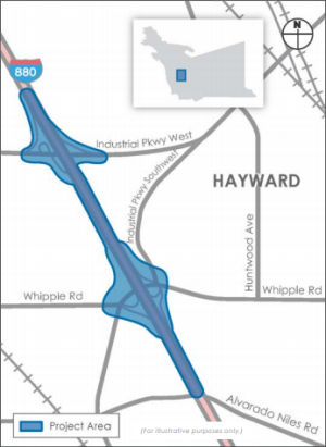
In January 2019, Mr. Roadshow reported that Caltrans
has plans to rebuild the I-880/Whipple Road-Industrial Parkway Southwest
and I-880/Industrial Parkway West interchanges. The project would include
ramp reconfigurations, modifications and replacement of bridges, street
realignments and restriping, and bicycle and pedestrian improvements in
Hayward and Union City. This will be a monstrous job, costing around $175
million with construction beginning in 2025. The Alameda CTC has set up a webpage on the project. The project fact sheet notes that I‐880/Whipple Road ramp intersections currently operate at or over
capacity, with a few movements experiencing high delay during a.m. and
p.m. peak hours. Observed queues for the northbound off‐ramp
approach at Whipple Road occasionally extend to the mainline.
Additionally, the Whipple Road–Industrial Parkway South West
interchange was identified by the cities of Union City and Hayward as
needing bicycle and pedestrian improvements to enhance the connectivity
between the east and west sides of I‐880. The planned improvements
include a northbound off-ramp, a southbound high occupancy vehicle (HOV)
bypass lane on the southbound loop off-ramp, bridge reconstruction over
I-880, and surface street improvements and realignment.
(Source: Mercury News, 1/23/2019; ProjectFact
Sheet)
In June 2021, the CTC approved amending the STIP to use
the funding available through the 2021 Mid-Cycle STIP and share
distribution of the federal Coronavirus Response and Relief Supplemental
Appropriations Act of 2021 funds (COVID Relief Funds) to add a new project
to the STIP: Route 880 Interchanges Improvements, at Industrial Parkway
West and at Whipple Road/Industrial Parkway Southwest (PPNO 0023L);
program $50K to the PS&E phase in FY 2022-23.
(Source: June 2021 CTC Agenda, Agenda Item
2.1a.(19))
In January 2023, the CTC approved for future
consideration of funding the following project for which a Negative
Declaration (ND) has been completed: I-880 Interchange Improvements
Project. I-880 in Alameda County (04-Ala-880, PM 13.0/14.8).
Interchange on and off ramp reconfigurations, modifications and/or
replacement of bridge structures, local roadway realignments and
restriping, and bicycle and pedestrian improvements on I-880, in Alameda
County. (PPNO 0023L). The project is located on I-880 from postmile 13.0
to 14.8, in Alameda County. The Department proposes to provide interchange
and local road improvements along the project area. The project is
currently programmed in the 2022 State Transportation Improvement Fund for
a total of $219,000,000 which includes Plans, Specifications, and
Estimate. Construction is estimated to begin 2024-25. The scope, as
described for the preferred alternative, is consistent with the project
scope as programmed by the Commission in the 2022 STIP.
(Source: January 2023 CTC Agenda, Agenda Item 2.2c.(1))
In March 2023, the CTC approved the following
allocation for a locally-administered STIP project: $50,000. 04-Ala-880
13.0/14.8. PPNO 04-0023L; ProjID 0418000067; EA 0Q280. I-880 Interchange
Improvements (Whipple Road/Industrial Parkway Southwest and Industrial
Parkway West). In the cities of Hayward and Union City. Interchange and
local road improvements on I-880 from 0.6 mile south of Whipple
Road/Industrial Parkway Southwest Interchange to 0.3 north of Industrial
Parkway West Interchange. Future consideration of funding approved under
Resolution E-23-01; January 2023. Contribution from other sources:
$15,550,000. Allocation: PS&E $50,000.
(Source: March 2023 CTC Agenda, Agenda Item 2.5c.(2) #1)
Route 880 Interchanges Improvements, Winton Avenue / A Street (~ ALA 17.448 to ALA 18.587)
 In October 2019, the Alameda CTC held an open house
regarding a project that would improve the Winton Avenue and A Street
interchanges. The I-880 Interchange Improvements Project aims to
reconfigure the interchanges at Winton Avenue and A Street and implement
complete streets features. The project intends to improve traffic
operations, safety, and accessibility to the retail and commercial land
uses at Winton Avenue and A Street. Proposed improvements include
reconfiguring the I-880 interchange at Winton Avenue to provide direct
access to the Southland Mall and implement Complete Streets features, and
reconstructing the I-880/A Street interchange to widen A Street from five
to six lanes and provide additional lane capacity for potential future
freeway widening. Improvements will also involve modifying signals and
reconfiguring intersections to improve truck turning maneuvers. The
project will also implement bike lanes and pedestrian friendly design at
both interchanges, modify signals and reconfigure intersections to improve
traffic flow, and improve weaving operations along the segment of I-880
between the Winton Avenue and A Street interchanges.
In October 2019, the Alameda CTC held an open house
regarding a project that would improve the Winton Avenue and A Street
interchanges. The I-880 Interchange Improvements Project aims to
reconfigure the interchanges at Winton Avenue and A Street and implement
complete streets features. The project intends to improve traffic
operations, safety, and accessibility to the retail and commercial land
uses at Winton Avenue and A Street. Proposed improvements include
reconfiguring the I-880 interchange at Winton Avenue to provide direct
access to the Southland Mall and implement Complete Streets features, and
reconstructing the I-880/A Street interchange to widen A Street from five
to six lanes and provide additional lane capacity for potential future
freeway widening. Improvements will also involve modifying signals and
reconfiguring intersections to improve truck turning maneuvers. The
project will also implement bike lanes and pedestrian friendly design at
both interchanges, modify signals and reconfigure intersections to improve
traffic flow, and improve weaving operations along the segment of I-880
between the Winton Avenue and A Street interchanges.
(Source: Winton/A Avenue Project Page, Retrieved 9/2021)
Current problems identified for the I-880/Winton Avenue
Interchange include: (•) The interchange has a four-quadrant
cloverleaf configuration with ramps running freely onto Winton Avenue
without intersection control. (•) Pedestrians and bicyclists must
cautiously look for vehicles approaching at high speeds when crossing the
uncontrolled ramps along Winton Avenue. (•) Through traffic and
vehicles heading to Southland Mall via the westbound Winton left-turn lane
creates congestion and queues along Winton Avenue, Southland Drive and the
I-880 southbound off-ramp. Problems identified for the I-880/A Street
Interchange include: (•) Congestion during peak periods affects both
directions. (•) Vehicular queues in the two adjacent left-turn lanes
cause operational and safety issues. (•) The existing underpass
provides non-standard design features and lacks bicycle lanes. Initial
cost estimates are as follows: ($ × 1,000): Planning/Scoping $940;
PE/Environmental $4,368; Final Design (PS&E) $8,942; Right-of-Way
$1,750; Construction $79,000; Total Cost Estimate $95,000.
(Source: Winton/A Avenue Project Page, Retrieved 9/2021)
In June 2021, the CTC approved amending the STIP to use
the funding available through the 2021 Mid-Cycle STIP and share
distribution of the federal Coronavirus Response and Relief Supplemental
Appropriations Act of 2021 funds (COVID Relief Funds) to add a new project
to the STIP: Route 880 Interchanges Improvements, at Winton Avenue and at
A Street (PPNO 0023M); program $50K to the PS&E phase in FY 2022-23.
(Source: June 2021 CTC Agenda, Agenda Item
2.1a.(19))
Marina to Helgenberger Project (~ ALA 22.836 to ALA 25.52)
 In January 2011, the CTC approved for future consideration of funding a project in Alameda
County that will extend the existing southbound HOV lane from south of the
Marina Boulevard Overcrossing in the city of San Leandro to Hegenberger
Road in the city of Oakland. The project is programmed in the Corridor
Mobility Improvement Account and includes federal and local funds.
Construction is estimated to begin in Fiscal Year 2011-12. Total estimated
project cost is $108,000,000 for capital and support. The project will
result in no significant impacts to the environment. Avoidance and
minimization measures would reduce any potential effects on water quality,
hazardous waste and materials, air quality, noise, wetlands and other
waters, and threatened and endangered species.
In January 2011, the CTC approved for future consideration of funding a project in Alameda
County that will extend the existing southbound HOV lane from south of the
Marina Boulevard Overcrossing in the city of San Leandro to Hegenberger
Road in the city of Oakland. The project is programmed in the Corridor
Mobility Improvement Account and includes federal and local funds.
Construction is estimated to begin in Fiscal Year 2011-12. Total estimated
project cost is $108,000,000 for capital and support. The project will
result in no significant impacts to the environment. Avoidance and
minimization measures would reduce any potential effects on water quality,
hazardous waste and materials, air quality, noise, wetlands and other
waters, and threatened and endangered species.
(Image from Oakland Tribute, 1/9/2013)
In January 2012, the CTC updated the Marina to Hegenberger project. The project scope includes extending the existing southbound high occupancy vehicle lane from its current terminal point at just south of the Marina Boulevard Overcrossing to Hegenberger Road. The project scope also includes reconstruction of the Davis Street Overcrossing and the Marina Boulevard along with widening of bridge structures over the Union Pacific Railroad (UPPR) lines and the San Leandro Creek. Once completed, these improvements will help alleviate congestion along the corridor and also will upgrade the facility to meet the safety and operational requirements. The amendment reflected a request from the City of San Leandro to include an additional scope of work relating to the improvements at the Davis Street Interchange in the existing CMIA project. These improvements will be funded by the City of San Leandro with its own local funds. Combing these improvements with the CMIA project will result in more efficient delivery and less inconvenience to the traveling public during the construction of the project. The funding profile was updated. The project was also split into three segments for delivery: (1) South Segment (PPNO 0036F): On Route 880 in Alameda County, from Marina Boulevard to Davis Street in San Leandro. Extend existing southbound HOV Lane; (2) North Segment (PPNO 0036J): On Route 880 in Alameda County, from Davis Street to Hegenberger Road in Oakland. Extend existing southbound HOV Lane; (3) Follow-up Landscaping (PPNO 0036K): On Route 880 in Alameda County, from Marina Boulevard to Davis Street in San Leandro. Highway Planting.
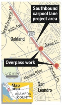
In January 2013, it was reported that Caltrans crews
will begin widening a three-mile stretch of I-880 in San Leandro to add a
southbound carpool lane and replace two overpasses. Completion of the
first segment, which spans from Hegenberger Road to just north of Davis
Street, is scheduled for the fall of 2014. The second segment, from Davis
Street to just south of Marina Boulevard, is slated to be done by spring
2016 and includes new overpasses at Davis Street and Marina Boulevard to
improve vertical clearance on I-880 and reduce the frequency of big rigs
with high loads hitting the bridges. Plans also include replacing 3,000
feet of soundwall, widening the San Leandro Creek Bridge, improving
pedestrian access and bike lanes on the Davis Street overpass and
reconstructing on- and offramps at 98ᵗʰ Avenue and Hegenberger
Road. The project -- estimated to cost $83.4 million -- aims to ease
congestion on I-880, which is expected to see a 30 percent increase in
traffic volume by 2035. A new left turn on westbound Marina Boulevard to
the Kaiser Permanente Medical Center development is also being considered.
(Source: Oakland Tribune, 1/9/2013)
In May 2022, the CTC authorized relinquishment of right of way,
consisting of collateral facilities and nonmotorized transportation
facilities, in the city of Oakland along Route 880 on Coral Road, Jones
Avenue, Hegenberger Road, and Edgewater Drive (3 segments, 04-Ala-880-PM
24.7 × 2, 25.5), under the terms and conditions as stated in the
Freeway Agreement dated January 17, 1995.
(Source: May 2022 CTC Agenda, Agenda Item 2.3c)
In October 2014, the CTC authorized relinquishment of right of way in the city of Oakland (City) along Route 880 on Oakport Street (~ ALA 26.699), consisting of a reconstructed city street. The City, by freeway agreement dated July 30, 2008 and by letter signed on August 26, 2014, waived the 90-day notice requirement and agreed to accept title upon relinquishment by the State.
Embarcadero Bridges - 5ᵗʰ Avenue, 29ᵗʰ Avenue, 23ʳᵈ Avenue, High Street (~ ALA 27.799 to ALA 30.611)
In July 2010, the CTC approved for future consideration of funding a project that will construct roadway and safety improvements on Route 880 at the 29ᵗʰ Avenue and 23ʳᵈ Avenue overcrossings in the city of Oakland. The project is programmed in the Trade Corridors Improvement Fund and the 2010 State Transportation Improvement Program and includes federal demonstration and local funds. Construction is estimated to begin in Fiscal Year 2012-13. Total estimated project cost is $96,787,000 for capital and support. In March 2012, the CTC amended the TCIF baseline agreement for TCIF Project 4 - I-880 Reconstruction, 29ᵗʰ-23ʳᵈ Avenue project (PPNO 0044C) to update the project delivery schedule. The project will reconstruct the 29ᵗʰ and 23ʳᵈ Avenue overcrossings. The project will also construct a number of on-ramp and off-ramp improvements within the project limits. These improvements will relieve traffic congestion within this major bottleneck on I-880. The project delivery has been delayed due of challenges in acquiring the necessary right of way. Due to multiple lien holders and a number of challenging utility and structure encroachments, obtaining the required acquisitions have been much more complicated than originally anticipated. The duration of construction has also increased from the original estimate of 26 months to 48 months due to revised staging requirements for the construction of various structures. Furthermore, the duration between Ready-to-List (RTL) and the Begin Construction milestones is being extended to six months to reflect the Commission meeting schedule for 2012.
There are plans to rebuild and seismically retrofit the Fifth Avenue and High Street Bridges in Oakland, as well as repaving I-880. They will also be rebuilding the 23ʳᵈ and 29ᵗʰ Street Bridges, and adding a SB HOV lane from Oakland to San Leandro. The work will also widen existing lanes from 11 to 12 feet, plus add 10-foot shoulders and improve the narrow cattle-chute-like ramps into decent merging areas.
In January 2013, the CTC approved amending the TCIF baseline agreement for TCIF Project 4 - I-880 Reconstruction, 29ᵗʰ-23ʳᵈ Avenue project (PPNO 0044C) to update the project funding plan and delivery schedule. The I-880 Reconstruction project will reconstruct the 29ᵗʰ and 23ʳᵈ Avenue overcrossings. The project will also construct a number of on-ramp and off-ramp improvements within the project limits. The East Bay Municipal Utility District (EBMUD) has recently completed the design plans for their waterline relocations. Based upon these latest cost estimates, the Right of Way (R/W) estimate has increased from $5,200,000 to $6,325,000, an increase of $1,125,000. The ACTC is proposing to cover this funding shortfall with local measure funds. Additionally, at the completion of the design phase, it was determined there was sufficient capacity in the programmed construction capital to fully fund the project construction capital estimate and a change in construction support programming was necessary. Therefore, $5,700,000 was subtracted from construction capital and added to construction support, resulting in no net change on the amount coming from the SHOPP funds. The project delivery has been delayed by two months. This delay is due to the complexities of the project and also due to a large number of agencies involved in the project development activities. Construction is now planned to begin in July 2013, and end in July 2017.
In August 2011, the CTC approved $18,000,000 in SHOPP funding to rehabilitate 12.0 lane miles of roadway in Oakland, from 0.5 mile north of High Street to 0.5 mile north of Fifth Avenue, to improve the ride quality, prevent further deterioration of the road surface, minimize the costly roadway repairs and extend the pavement service life.
In August 2011, there was an update on the Interstate 880 Corridor Improvement Project. This is the eight-year effort to upgrade
a 15-mile stretch of roadway between Oakland and Hayward. In August 2011,
it was reported that Caltrans was opening a , is entering yet another new
phase. This coming Sunday, the California Department of Transportation
(Caltrans) will shift traffic onto the new I-880 southbound bridge over
Fifth Avenue in Oakland (this bridge had been temporarily used as an
on-ramp by vehicles entering the freeway from Oak Street). The lane shift
will give Caltrans construction crews space to begin demolition and
reconstruction of the current 62-year-old bridge’s southbound lanes.
If all goes as planned, the reconstruction will be completed in the summer
of 2013. In November 2011, Gary Richards of the SJMN noted that the new
bridge will be taller than then old bridge, primarily because designers
wanted to use sections of the old bridge as part of the temporary support
system for construction of the new one. The High Street portion of I-880
was built in 1950 and is considered by Caltrans to be vulnerable to damage
in the event of a major earthquake. According to the agency, when
construction is completed motorists should notice a smoother ride, better
visibility and benefit from larger roadway shoulders to accommodate
disabled vehicles. The exit ramps are being reconfigured to reduce
back-ups entering and exiting the freeway at the 42ⁿᵈ Avenue
interchange. Construction of the 23ʳᵈ and 29ᵗʰ
Avenue bridges to Interstate 880 is scheduled to begin in 2012. Nearby,
The Fruitvale Avenue Overhead Project was completed in 2009.
(Source: Alameda Patch)
The SAFETEA-LU act, enacted in August 2005 as the reauthorization of TEA-21, provided the following expenditures on or near this route:
In December 2021, the CTC authorized relinquishment of 04-Ala-880-PM
28.6/28.8 (2 segments): Right of way, consisting of collateral facilities
in the city of Oakland along Route 880 on East 9ᵗʰ Street
(Division Street) and Lisbon Avenue, under the terms and conditions as
stated in the freeway agreement dated May 16, 2013.
(Source: December 2021 CTC Agenda, Agenda Item
2.3c)
Route 880 Oakland/Alameda Access, Broadway-Jackson, Improvement (04-Ala-260 R0.78/R1.90, 04-Ala-880 30.47/31.61)
 Caltrans, in partnership with the Alameda County Transportation Commission (Alameda
CTC), proposes to improve mobility and accessibility, traffic operations,
and bicycle and pedestrian facilities through the Oakland Alameda Access
Project (proposed project) on Route 260 (R0.78/R1.90) and on I-880
(30.47/31.61) in the cities of Oakland and Alameda in Alameda County,
California. The EIR for the project notes that the Oakland Alameda Access
Project, formerly known as the Broadway/Jackson Interchange Project and
then the Broadway/Jackson Street Interchange Improvements Project, has
been studied for over 20 years. As of September 2020, three Project Study
Reports (PSR), a Project Report (PR), and a Feasibility Study evaluated
numerous alternatives to address the Purpose and Need. A Draft PSR was
prepared in 1997, a subsequent PSR was completed in 2000, and a PR was
completed in 2002 for the Broadway/Jackson Street Interchange Improvements
Project. However, the recommended alternative did not have the support of
the local community, particularly key stakeholders in Chinatown, so it did
not proceed. In 2006, the City of Alameda revisited the project by
completing a Feasibility Study for the I-880/Broadway-Jackson Interchange
Improvements Project. The Feasibility Study recommended several new
alternatives and a PSR-Project Development Support (PDS)-Project
Initiation Document (PID) for the I-880/Broadway-Jackson Interchange
Improvements Project. This study was approved by Caltrans in March 2011.
Caltrans, in partnership with the Alameda County Transportation Commission (Alameda
CTC), proposes to improve mobility and accessibility, traffic operations,
and bicycle and pedestrian facilities through the Oakland Alameda Access
Project (proposed project) on Route 260 (R0.78/R1.90) and on I-880
(30.47/31.61) in the cities of Oakland and Alameda in Alameda County,
California. The EIR for the project notes that the Oakland Alameda Access
Project, formerly known as the Broadway/Jackson Interchange Project and
then the Broadway/Jackson Street Interchange Improvements Project, has
been studied for over 20 years. As of September 2020, three Project Study
Reports (PSR), a Project Report (PR), and a Feasibility Study evaluated
numerous alternatives to address the Purpose and Need. A Draft PSR was
prepared in 1997, a subsequent PSR was completed in 2000, and a PR was
completed in 2002 for the Broadway/Jackson Street Interchange Improvements
Project. However, the recommended alternative did not have the support of
the local community, particularly key stakeholders in Chinatown, so it did
not proceed. In 2006, the City of Alameda revisited the project by
completing a Feasibility Study for the I-880/Broadway-Jackson Interchange
Improvements Project. The Feasibility Study recommended several new
alternatives and a PSR-Project Development Support (PDS)-Project
Initiation Document (PID) for the I-880/Broadway-Jackson Interchange
Improvements Project. This study was approved by Caltrans in March 2011.
(Source: Draft Environmental Impact Report/Environmental Assessment and Draft Individual Section 4(f) Evaluation, Oakland Alameda Access Project, September 2020)
The September 2020 Draft EIR notes the following
alternatives:
(Source: Draft Environmental Impact Report/Environmental Assessment and Draft Individual Section 4(f) Evaluation, Oakland Alameda Access Project, September 2020)
Additional detail on the Build Alternative improvements
include the following:
(Source: Draft Environmental Impact Report/Environmental Assessment and Draft Individual Section 4(f) Evaluation, Oakland Alameda Access Project, September 2020)
In December 2020, it was reported that a plan that has
been decades in the works to reconfigure the ramps of I-880 in
Oakland’s Chinatown — and which thousands of Alameda commuters
use daily — to help ease traffic congestion is moving forward. Known
as the Oakland Alameda Access Project, the plans for around
Interstate 880 include the creation of a right-turn-only lane onto Fifth
Street at the exit of the Posey Tube, which carries traffic from Alameda
into Oakland, to provide almost direct access to the freeway both north
and south. The project also calls for widening the interstate’s
northbound Oak Street off-ramp and removing the northbound Broadway
off-ramp. Madison Street will be restriped to allow for two-way travel
between Fourth and Sixth streets. It currently is one-way for traffic
traveling west. Jackson will be restriped for one-way travel between Fifth
and Sixth. The changes also include increasing the width of a maintenance
walkway in the Webster Tube, which carries traffic from Oakland under the
Oakland Estuary into Alameda, from three to four feet to better support
pedestrians and cyclists. Work on the $120 million project by the Alameda
County Transportation Commission is expected to begin in the middle of
2023 and be finished in three years. Other parts of the plan include new
sidewalks on Fifth and Sixth streets in Oakland, a sidewalk that encircles
the Chinese Garden Park on Seventh Street in Chinatown, and a two-way
bicycle path on Oak and Sixth streets in Oakland. To learn more about the
project, review the draft environmental document and submit comments, go
to www.OaklandAlamedaAccessProject.com.
(Source: East Bay Times, 12/8/2020)
In June 2021, the CTC approved amending the STIP to use
the funding available through the 2021 Mid-Cycle STIP and share
distribution of the federal Coronavirus Response and Relief Supplemental
Appropriations Act of 2021 funds (COVID Relief Funds) to add a new project
to the STIP: Route 880 Oakland/Alameda Access, Broadway-Jackson,
Improvement (PPNO 0044D) and program $50K to the PS&E phase in FY
2022-23.
(Source: June 2021 CTC Agenda, Agenda Item
2.1a.(19))
In May 2022, the CTC approved for future consideration
of funding the following project: 04-Ala-880, PM 30.47/31.61; 04-Ala-260,
PM R0.78/R1.90. Oakland Alameda Access Project. Improve
connectivity and accessibility between Alameda and I-880 by way of Route 260 in Alameda County. (FEIR) (PPNO 0044D) (STIP) The project is
located on I-880 between postmile R30.47 and R31.61 and along Route 260
between postmile R0.78 and R1.90 in Alameda County. The proposed
project would improve multimodal safety for all users and reduce conflicts
between regional and local traffic by enhancing bicycle and pedestrian
accessibility and connectivity. It would also improve mobility and
accessibility between I-880 and Route 260, the City of Oakland downtown
neighborhoods and the City of Alameda, and reduce freeway-bound regional
traffic and congestion on local roadways and area neighborhoods. This
project is currently programmed in the 2020 State Transportation
Improvement Program (STIP) for a total of $127,728,000, which includes
Right of Way (capital and support). Construction is estimated to
begin in 2024-25. The scope, as described for the preferred
alternative, is consistent with the project scope as programmed by the
Commission in the 2020 STIP. Under the Build Alternative, access to
northbound and southbound I-880 from the Posey Tube would be improved by
adding a right-turn-only lane from the Posey Tube to 5th Street and a new
horseshoe connector at Jackson Street below the I-880 viaduct that would
connect to the existing northbound I-880/Jackson Street on-ramp. The Build
Alternative would also include a two-way bicycle/pedestrian walkway
through the Posey Tube. The construction of a right-turn-only lane from
the Posey Tube Approach to 5th Street would modify the Tube in Oakland by
demolishing 175 feet of the eastern Approach wall and staircase for
a new turn lane onto 5th Street. The Approach’s extant straight wall
would be replaced by a new curved wall that would extend onto 5th Street.
The construction of the left-turn-only lane from the Posey Tube exit to
6th Street would modify the Tube by demolishing 93 feet of the Oakland
Approach’s western wall, including the existing western pylon base.
The Approach’s existing straight walls would be replaced by new
walls that would extend onto 5th Street and 6th Street, respectively.
There likely will not be sufficient room under the I-880 viaduct to
relocate the existing western pylon base at the end of the proposed
western wall. Relocation options will be evaluated following additional
data collected during the project’s design phase. The eastern pylon
base will be preserved in place and stabilized as part of this project.
The demolition of the Approach’s eastern wall and stairs, the
demolition of the western wall including its pylon base, the construction
of the new wall with a different configuration, and the construction of
the bicycle/pedestrian ramp around the Portal building would result in the
partial removal of, physical destruction of, or damage to this historic
property under 36 CFR 800.5(a)(2)(i) and (ii). A two-way
bicycle/pedestrian accessible ramp would be installed at the Posey
Tube’s Oakland exit. This ramp would replace the existing staircase
attached to the Oakland Approach’s eastern wall, and would
transition to an at-grade path that wraps around the Oakland Portal
building. The path would replace the existing concrete sidewalk and curb
on the west (4th Street) side of the building. The construction of the
bicycle/pedestrian walkway at or near the Portal building would result in
the partial removal of, physical destruction of, or damage to this
historic property under 36 CFR 800.5(a)(2)(i) and (ii).
(Source: May 2022 CTC Agenda, Agenda Item 2.2c.(8))
In January 2023, the CTC amended the Local Partnership
Formulaic Program to add the Oakland Alameda Access Project in Alameda
County (04-Ala-260 R0.78/R1.90, 04-Ala-880 30.47/31.61) and program
$196,000 in fiscal year 2022-23. This project will provide active
transportation facilities, pedestrian and bicyclist safety enhancements,
realignment of offramps and onramps to address circulation issues, as well
as other roadway improvements. The anticipated benefits of this project
include improved multimodal mobility and accessibility between the cities
of Oakland and Alameda and easing local roadway congestion around I-880
and Route 260.
(Source: January 2023 CTC Agenda, Agenda Item 4.10)
In March 2023, the CTC approved the following
allocation for a locally-administered STIP project: $50,000. 04-Ala-880
R30.47/R31.61. PPNO 04-0044D; ProjID 0400000326; EA 0G360. Oakland
Alameda Access Project. Project is located on I-880 and Route 260
between 5th Avenue Overhead and 5th and 6th Street Viaduct within the
Cites of Oakland and Alameda in Alameda County. The project proposes to
improve access along I-880 and in and around the Webster and Posey Tubes
(Route 260 tunnels under the Oakland Estuary [Tubes]), downtown Oakland,
and the City of Alameda. Proposed improvements also include
implementation of follow up landscaping work to restore removed vegetation
required by the highway improvements. CEQA - EIR, 08/20/2021. NEPA -
FONSI, 08/20/2021. Future consideration of funding approved under
Resolution E-22-36; May 2022. Contribution from other sources:
$12,000,000. Allocation: PS&E $50,000.
(Source: March 2023 CTC Agenda, Agenda Item 2.5c.(2) #2)
In June 2023, the CTC approved the following allocation
for a locally-administered LPP (Formulaic) project: $196,000. 04-Ala-880
R30.47/R31.61. PPNO 04-0044D; ProjID 0400000326; EA 0G360. Oakland
Alameda Access Project. Project is located on I-880 and Route 260
between 5th Avenue Overhead and 5th and 6th Street Viaduct within the
Cites of Oakland and Alameda in Alameda County. The project proposes to
improve access along I-880 and in and around the Webster and Posey Tubes
(Route 260 tunnels under the Oakland Estuary [Tubes]), downtown Oakland,
and the City of Alameda. Proposed improvements also include
implementation of follow up landscaping work to restore removed vegetation
required by the highway improvements. CEQA - EIR, 08/20/2021. NEPA -
FONSI, 08/20/2021. Future consideration of funding approved under
Resolution E-22-36; May 2022. Allocation: R/W $196,000.
(Source: June 2023 CTC Agenda, Agenda Item 2.5s.(2) #1)
In October 2023, the CTC approved the following
amendment request for the Local Partnership Program: The Alameda County
Transportation Commission requests to amend the Oakland Alameda Access
Project in Alameda County and add $7,281,000 of its available 2022
Formulaic Program funding to the Construction phase in fiscal year
2024-25. This project was programmed at the January 2023 Commission
meeting with 2020 Formulaic Program funds to the Right-of-Way phase. This
project will remove and modify existing freeway ramps, modify the
connection from the Posey Tube (Route 260) to I-880, construct Class IV
two-way cycle tracks in Oakland, and implement bicycle and pedestrian
improvements near the Posey Tube and the Webster Tube. The anticipated
benefits of this project are enhanced safety, reduction in greenhouse gas
emissions, and providing multimodal choices for travelers.
(Source: October 2023 CTC Agenda, Agenda Item 4.26)
In May 2014, the CTC authorized relinquishment of right of way in the city of Oakland along Route 880 from Market Street to West Grand Avenue (~ ALA R32.113 to ALA R34.538L), consisting of collateral facilities. The City, by freeway agreement dated July 27, 1993 agreed to accept title and by letter dated March 7, 2014, waived the 90-day notice requirement and agreed to accept title upon relinquishment by the State. It also authorized relinquishment of right of way in the city of Oakland along Route 880S on Maritime Street, consisting of collateral facilities. The City, by letter dated February 11, 2014, waived the 90-day notice requirement and agreed to accept title upon relinquishment by the State.
MacArthur Maze Vertical Clearance Project – 80 (ALA PM 2.8)/580 (ALA PM 46.5R & 46.5L)/880 (ALA PM 34.5L)
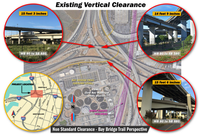 In March 2019, Caltrans started holding public hearings on the MacArthur Maze Vertical Clearance Project, whichwould to increase the vertical clearances at three locations within
the MacArthur Maze Interchange (MacArthur Maze or Maze) in the City of
Oakland, Alameda County. Two of the locations are along the connector from
westbound (WB) I-80 to southbound (SB) I-880, as it crosses below the WB
and eastbound (EB) I-580 overcrossings. The third location is along the
connector from WB I-80 to EB I-580 as it crosses below the connector from
WB I-580 to WB I-80. The existing vertical clearance at these three
locations does not meet the current Caltrans standard of 16 feet 6 inches
and impedes the safe and efficient movement of oversized vehicles and
loads through the Maze. The project is proposed to increase the vertical
clearance of the structures in the Maze to allow for more efficient travel
of oversized vehicles.
In March 2019, Caltrans started holding public hearings on the MacArthur Maze Vertical Clearance Project, whichwould to increase the vertical clearances at three locations within
the MacArthur Maze Interchange (MacArthur Maze or Maze) in the City of
Oakland, Alameda County. Two of the locations are along the connector from
westbound (WB) I-80 to southbound (SB) I-880, as it crosses below the WB
and eastbound (EB) I-580 overcrossings. The third location is along the
connector from WB I-80 to EB I-580 as it crosses below the connector from
WB I-580 to WB I-80. The existing vertical clearance at these three
locations does not meet the current Caltrans standard of 16 feet 6 inches
and impedes the safe and efficient movement of oversized vehicles and
loads through the Maze. The project is proposed to increase the vertical
clearance of the structures in the Maze to allow for more efficient travel
of oversized vehicles.
(Source: MacArthur Maze Vertical Clearance Project, Initial Study with Proposed Negative Declaration/Environmental Assessment, January 2019)
The alternatives are Alternative A: Bridge Lowering, Alternative B: Bridge Raising, Alternative C: Partial Bridge Replacement, Alternative D: Partial Deck Reconstruction, and the No-Build Alternative. The project proposes to increase the vertical clearances at three locations in the MacArthur Maze interchange to the current Caltrans standard of 16 feet 6 inches in order to allow for freight and oversized vehicles to travel through these major connectors. At present, the connector from WB I-80 to EB I-580 has 14 feet 9 inches of vertical clearance as it passes under the WB I-580 to WB I-80 connector. The connector from WB I-80 to SB I-880 has a vertical clearance of 15 feet 3 inches as it passes under the WB I-580 to WB I-80 connector, and a vertical clearance of 15 feet 6 inches as it passes under the EB I-80 to EB I-580 connector. Currently, The WB I-80 to SB I-880 connector is a two-lane freeway built in 1998 with 4-foot-wide left and right shoulders. The WB I580 to WB I-80 connector is a three-lane freeway built in 1935 and widened in 2006 with 3-footwide left and right shoulders. The EB I-80 to EB I-580 connector is a three-lane freeway built in 1955 and widened in 1962 with 2-foot-wide left and right shoulders.
 Commuter Lanes
In Alameda County, there are southbound HOV lanes from Marina Blvd to Whipple Road, for a total length of 9.7 miles. These were opened in September 1991 and ran from A Street to N of Tennyson, and were extended in December 1991 to Industrial Parkway. In 1992, they were extended from Route 238 to A Street, and in 1993, they were extended to Whipple Road. Lastly, in 1995, they were extended from Marina Blvd to Route 238. They require two or more occupants, and operate weekdays 5:00am-9:00am and 3:00pm-7:00pm.
Additional lanes from Mowry Avenue to Alvarado Niles Road were opened in October 1998. In December, these were extended from Mowry to Mission Blvd (Route 262).
Northbound, in Alameda County, there are HOV lanes from Whipple Road to 1 mi S of Route 238, for a total length of 6.3 mi. These were opened in 1991 from N of Tennyson to A Street, and extended to Industrial Parkway later that year. They were extended to Route 238 in 1992, and to Whipple Road in 1993. They were shortened from Whipple Road to 1 mi S of Route 238 in 1996. They require two or more occupants, and operate weekdays 5:00am-9:00am and 3:00pm-7:00pm.
In October 1998, lanes were opened from Mowry to Alvarado Nile Road. In November, they were extended from Mission Blvd (Route 262) to Mowry.
HOV lanes are also planned as follows:
A 2001 survey showed that more than 8,300 people carpooled between Marina Boulevard and Whipple Road in the East Bay, up from 4,000 in 1996.
 Naming
The portion of the freeway between US 101 in San Jose and Route 80 is named the "East Shore Freeway". This section of freeway was named by Senate Concurrent Resolution 99, Chapter 229 in 1968.
 I-880 from Route 101 in San Jose to Route 80 at
the San Francisco-Oakland Bay Bridge in Oakland is named the "Nimitz
Freeway". Named by Senate Concurrent Resolution 23, Chapter 84 in
1958. It was named after Fleet Admiral Chester William Nimitz. Admiral
Nimitz was born on 24 February 1885 in Fredericksburg, Texas. He had his
sights set on an Army career and while a student at Tivy High School,
Kerrville, Texas, he tried for an appointment to West Point. When none was
available, he took a competitive examination for Annapolis and was
selected and appointed from the Twelfth Congressional District of Texas in
1901. He left high school to enter the Naval Academy Class of 1905. At the
Academy Nimitz was an excellent student, especially in mathematics and
graduated with distinction. After graduation he joined USS Ohio in San
Francisco and cruised in her to the Far East. On 31 January 1907, after
the two years' sea duty then required by law, he was commissioned Ensign,
and took command of the gunboat USS Panay. He then commanded USS Decatur
and was court martialed for grounding her, an obstacle in his career which
he overcame. He returned to the U. S. in 1907 and was ordered to duty
under instruction in submarines. His first submarine was USS Plunger (A-
1). He successively commanded USS Snapper, USS Narwal and USS Skipjack
until 1912. On 20 March of that year, Nimitz, then a Lieutenant, and
commanding officer of the submarine E-1 (formerly Skipjack), was awarded
the Silver Lifesaving Medal by the Treasury Department for his heroic
action in saving W.J. Walsh, Fireman second class, USN, from drowning. He
had one year in command of the Atlantic Submarine Flotilla before coming
ashore in 1913 for duty in connection with building the diesel engines for
the tanker USS Maumee at Groton, Conn. He subsequently served as Executive
Officer and Engineering Officer of the Maumee until 1917 when he was
assigned as Aide and Chief of Staff to COMSUBLANT. He served in that
billet during World War I. In September 1918 he came ashore to duty in the
office of the Chief of Naval Operations and was a member of the Board of
Submarine Design. In 1919, he had one year's duty as Executive Officer of
the battleship USS South Carolina. After that he continued his duty in
submarines in Pearl Harbor as Commanding Officer USS Chicago and COMSUBDIV
Fourteen. In 1922 after studying at the Naval War College, he served as
Chief of Staff to Commander Battle Forces and later Commander in Chief,
U.S. Fleet (Admiral S. S. Robinson) . In the meantime, the ROTC program
had been initiated and in 1926 he became the first Professor of Naval
Science and Tactics for the Unit at the University of California at
Berkley. Throughout the remainder of his life he retained a close
association with the University. After three years in that assignment, in
1929, he again had sea duty in the submarine service as Commander
Submarine Division Twenty for two years and then went ashore to command
USS Rigel and decommissioned destroyers at the base in San Diego. In 1933
he was assigned to his first large ship command, the heavy cruiser USS
Augusta which served mostly as flagship of the Asiatic Fleet. Coming
ashore in 1935 he served three years as Assistant Chief of the Bureau of
Navigation. His next sea command was in flag rank as Commander Cruiser
Division Two and then as Commander Battle Division One until 1939, when he
was appointed as Chief of the Bureau of Navigation for four years. In
December 1941, however, he was designated as Commander in Chief, Pacific
Fleet and Pacific Ocean Areas, where he served throughout the war. On 19
December 1944, he was advanced to the newly created rank of Fleet Admiral,
and on 2 September 1945, was the United States signatory to the surrender
terms aboard the battleship USS Missouri in Tokyo Bay. He hauled down his
flag at Pearl Harbor on 26 Nov. 1945, and on 15 December relieved Fleet
Admiral E.J. King as Chief of Naval Operations for a term of two years. On
01 January 1948, he reported as special Assistant to the Secretary of the
Navy in the Western Sea Frontier. In March of 1949, he was nominated as
Plebiscite Administrator for Kashmir under the United Nations. When that
did not materialize he asked to be relieved and accepted an assignment as
a roving goodwill ambassador of the United Nations. Thereafter, he took an
active interest in San Francisco community affairs, in addition to his
continued active participation in affairs of concern to the Navy and the
country. He served for eight years as a regent of the University of
California and did much to restore goodwill with Japan by raising funds to
restore the battleship Mikasa, Admiral Togo's flagship at Tsushima in
1905. He died on 20 February 1966.
I-880 from Route 101 in San Jose to Route 80 at
the San Francisco-Oakland Bay Bridge in Oakland is named the "Nimitz
Freeway". Named by Senate Concurrent Resolution 23, Chapter 84 in
1958. It was named after Fleet Admiral Chester William Nimitz. Admiral
Nimitz was born on 24 February 1885 in Fredericksburg, Texas. He had his
sights set on an Army career and while a student at Tivy High School,
Kerrville, Texas, he tried for an appointment to West Point. When none was
available, he took a competitive examination for Annapolis and was
selected and appointed from the Twelfth Congressional District of Texas in
1901. He left high school to enter the Naval Academy Class of 1905. At the
Academy Nimitz was an excellent student, especially in mathematics and
graduated with distinction. After graduation he joined USS Ohio in San
Francisco and cruised in her to the Far East. On 31 January 1907, after
the two years' sea duty then required by law, he was commissioned Ensign,
and took command of the gunboat USS Panay. He then commanded USS Decatur
and was court martialed for grounding her, an obstacle in his career which
he overcame. He returned to the U. S. in 1907 and was ordered to duty
under instruction in submarines. His first submarine was USS Plunger (A-
1). He successively commanded USS Snapper, USS Narwal and USS Skipjack
until 1912. On 20 March of that year, Nimitz, then a Lieutenant, and
commanding officer of the submarine E-1 (formerly Skipjack), was awarded
the Silver Lifesaving Medal by the Treasury Department for his heroic
action in saving W.J. Walsh, Fireman second class, USN, from drowning. He
had one year in command of the Atlantic Submarine Flotilla before coming
ashore in 1913 for duty in connection with building the diesel engines for
the tanker USS Maumee at Groton, Conn. He subsequently served as Executive
Officer and Engineering Officer of the Maumee until 1917 when he was
assigned as Aide and Chief of Staff to COMSUBLANT. He served in that
billet during World War I. In September 1918 he came ashore to duty in the
office of the Chief of Naval Operations and was a member of the Board of
Submarine Design. In 1919, he had one year's duty as Executive Officer of
the battleship USS South Carolina. After that he continued his duty in
submarines in Pearl Harbor as Commanding Officer USS Chicago and COMSUBDIV
Fourteen. In 1922 after studying at the Naval War College, he served as
Chief of Staff to Commander Battle Forces and later Commander in Chief,
U.S. Fleet (Admiral S. S. Robinson) . In the meantime, the ROTC program
had been initiated and in 1926 he became the first Professor of Naval
Science and Tactics for the Unit at the University of California at
Berkley. Throughout the remainder of his life he retained a close
association with the University. After three years in that assignment, in
1929, he again had sea duty in the submarine service as Commander
Submarine Division Twenty for two years and then went ashore to command
USS Rigel and decommissioned destroyers at the base in San Diego. In 1933
he was assigned to his first large ship command, the heavy cruiser USS
Augusta which served mostly as flagship of the Asiatic Fleet. Coming
ashore in 1935 he served three years as Assistant Chief of the Bureau of
Navigation. His next sea command was in flag rank as Commander Cruiser
Division Two and then as Commander Battle Division One until 1939, when he
was appointed as Chief of the Bureau of Navigation for four years. In
December 1941, however, he was designated as Commander in Chief, Pacific
Fleet and Pacific Ocean Areas, where he served throughout the war. On 19
December 1944, he was advanced to the newly created rank of Fleet Admiral,
and on 2 September 1945, was the United States signatory to the surrender
terms aboard the battleship USS Missouri in Tokyo Bay. He hauled down his
flag at Pearl Harbor on 26 Nov. 1945, and on 15 December relieved Fleet
Admiral E.J. King as Chief of Naval Operations for a term of two years. On
01 January 1948, he reported as special Assistant to the Secretary of the
Navy in the Western Sea Frontier. In March of 1949, he was nominated as
Plebiscite Administrator for Kashmir under the United Nations. When that
did not materialize he asked to be relieved and accepted an assignment as
a roving goodwill ambassador of the United Nations. Thereafter, he took an
active interest in San Francisco community affairs, in addition to his
continued active participation in affairs of concern to the Navy and the
country. He served for eight years as a regent of the University of
California and did much to restore goodwill with Japan by raising funds to
restore the battleship Mikasa, Admiral Togo's flagship at Tsushima in
1905. He died on 20 February 1966.
(Source: Excerpted from ADM Nimitz's official biography in the Navy History Archives; Image source: Corco Highways; Wikipedia)
 The interchange at I-880 (ALA 880 16.664) and Route 92 (ALA 092 6.328) in the County of
Alameda is named the CHP Officer Andrew J. Camilleri Memorial
Interchange. It was named in memory of Andrew Joseph Camilleri,
Sr., who was born in February 1984 in San Jose, California. Officer
Camilleri graduated from Merrill F. West High School in Tracy, California,
in 2002, and worked for Clark Pest Control for 13 years after graduation.
Officer Camilleri, badge number 21653, graduated from the California
Highway Patrol Academy in 2017 and was assigned to patrol the Hayward area
upon graduation, where he proudly served for 16 months before making the
ultimate sacrifice. California Highway Patrol Officer Camilleri was killed
in the line of duty on December 24, 2017, when an errant driver traveling
southbound on I-880 collided with his patrol vehicle. Officer Camilleri
was transported to St. Rose Hospital, where he ultimately succumbed to his
injuries. Named by Assembly Concurrent Resolution (ACR) 120, Res. Chapter
39, 09/14/20.
The interchange at I-880 (ALA 880 16.664) and Route 92 (ALA 092 6.328) in the County of
Alameda is named the CHP Officer Andrew J. Camilleri Memorial
Interchange. It was named in memory of Andrew Joseph Camilleri,
Sr., who was born in February 1984 in San Jose, California. Officer
Camilleri graduated from Merrill F. West High School in Tracy, California,
in 2002, and worked for Clark Pest Control for 13 years after graduation.
Officer Camilleri, badge number 21653, graduated from the California
Highway Patrol Academy in 2017 and was assigned to patrol the Hayward area
upon graduation, where he proudly served for 16 months before making the
ultimate sacrifice. California Highway Patrol Officer Camilleri was killed
in the line of duty on December 24, 2017, when an errant driver traveling
southbound on I-880 collided with his patrol vehicle. Officer Camilleri
was transported to St. Rose Hospital, where he ultimately succumbed to his
injuries. Named by Assembly Concurrent Resolution (ACR) 120, Res. Chapter
39, 09/14/20.
(Image source: Officer Down Memorial Page)
 The portion of I-880 between Washington Avenue
and Marina Boulevard in the City of San Leandro (~ ALA 20.775 to ALA
22.946) is named the "Nels Dan Niemi Memorial Highway". This
segment was named in memory of San Leandro Police Department Officer Nels
Daniel (Dan) Niemi, born on October 2, 1962. On July 25, 2005, Officer
Niemi was working an overtime shift and was dispatched to a disturbance
call at the 14600 block of Doolittle Drive in San Leandro. The caller said
there were juveniles loitering and creating a disturbance in that area.
Officer Niemi arrived by himself and approached a group of male
individuals. As he started talking to them and getting their
identification, one of the subjects, without warning or provocation,
pulled out a semiautomatic handgun and pointed it at Officer Niemi's face.
The suspect shot and killed Officer Niemi. An extensive manhunt was
conducted and the alleged shooter was captured the next day. Named by
Senate Concurrent Resolution (SCR) 41, Resolution Chapter 91, on
7/10/2007.
The portion of I-880 between Washington Avenue
and Marina Boulevard in the City of San Leandro (~ ALA 20.775 to ALA
22.946) is named the "Nels Dan Niemi Memorial Highway". This
segment was named in memory of San Leandro Police Department Officer Nels
Daniel (Dan) Niemi, born on October 2, 1962. On July 25, 2005, Officer
Niemi was working an overtime shift and was dispatched to a disturbance
call at the 14600 block of Doolittle Drive in San Leandro. The caller said
there were juveniles loitering and creating a disturbance in that area.
Officer Niemi arrived by himself and approached a group of male
individuals. As he started talking to them and getting their
identification, one of the subjects, without warning or provocation,
pulled out a semiautomatic handgun and pointed it at Officer Niemi's face.
The suspect shot and killed Officer Niemi. An extensive manhunt was
conducted and the alleged shooter was captured the next day. Named by
Senate Concurrent Resolution (SCR) 41, Resolution Chapter 91, on
7/10/2007.
(Image source: SF Gate)
 The portion of I-880 in Alameda County between northbound PM ALA 26.61 and
southbound PM ALA 27.63 is named the "California Highway Patrol Officer
Brent William Clearman Memorial Freeway" (signed as "CHP Officer
Brent William Clearman Memorial Freeway") This segment was named in
memory of Brent William Clearman, born on January 1, 1973, in Astoria,
Oregon. He later relocated to the Bay Area, and lived in such cities as
Daly City, Antioch, Vacaville, and Concord, California. Prior to
graduation from the California Highway Patrol Academy in 2005, Officer
Clearman served his country in the Marine Corps as a sniper, and later
moved up to instructor. As such, Officer Clearman shared his extensive
knowledge and skills with others, and continued on to teach sniper tactics
to law enforcement agencies. After graduation from the California Highway
Patrol Academy, Officer Clearman, Badge Number 17843, was assigned to the
Oakland area, Beat 370. On Aug. 5, 2006, a hit-and-run driver, Russell
Rodrigues, struck Clearman after the officer had pulled over and left his
patrol car to investigate a minor accident in Alameda County. The officer,
a former Marine and Iraq war veteran who lived in Concord, was immediately
transported to a local hospital where he succumbed to his injuries the
next day. Rodrigues, a former sheriff's jail technician, was sentenced to
four years in prison in October 2006. Named by Senate Concurrent
Resolution (SCR) 132, Resolution Chapter 141, on 9/9/2008.
The portion of I-880 in Alameda County between northbound PM ALA 26.61 and
southbound PM ALA 27.63 is named the "California Highway Patrol Officer
Brent William Clearman Memorial Freeway" (signed as "CHP Officer
Brent William Clearman Memorial Freeway") This segment was named in
memory of Brent William Clearman, born on January 1, 1973, in Astoria,
Oregon. He later relocated to the Bay Area, and lived in such cities as
Daly City, Antioch, Vacaville, and Concord, California. Prior to
graduation from the California Highway Patrol Academy in 2005, Officer
Clearman served his country in the Marine Corps as a sniper, and later
moved up to instructor. As such, Officer Clearman shared his extensive
knowledge and skills with others, and continued on to teach sniper tactics
to law enforcement agencies. After graduation from the California Highway
Patrol Academy, Officer Clearman, Badge Number 17843, was assigned to the
Oakland area, Beat 370. On Aug. 5, 2006, a hit-and-run driver, Russell
Rodrigues, struck Clearman after the officer had pulled over and left his
patrol car to investigate a minor accident in Alameda County. The officer,
a former Marine and Iraq war veteran who lived in Concord, was immediately
transported to a local hospital where he succumbed to his injuries the
next day. Rodrigues, a former sheriff's jail technician, was sentenced to
four years in prison in October 2006. Named by Senate Concurrent
Resolution (SCR) 132, Resolution Chapter 141, on 9/9/2008.
(Image source: NorCal C.O.P.S. Jan 2010; KSBW)
 The portion of I-880 from the 23ʳᵈ Avenue Overcrossing to the
16ᵗʰ Avenue Overcrossing (ALA 28.93 to ALA 29.70) in the County
of Alameda is named the "CHP Officer William P. Sniffen Memorial
Highway". It was named in memory of Officer William Prestige
Sniffen, who was born on September 11, 1941, to William and Elsie, in
Honolulu, Hawaii. Upon graduation from the CHP Academy in July 1966,
Officer Sniffen was transferred to the San Leandro area and was later
transferred to the Oakland area. Officer Sniffen was killed in the line of
duty on April 5, 1973, while pursuing a speeding motorist on the Nimitz
Freeway. The vehicle he was pursuing rear-ended another car and burst into
flames. Officer Sniffen was unable to stop and slid underneath the burning
vehicle. Officer Sniffen was a hard-working and dedicated officer who
loved his job and enjoyed the people he worked with. He was known for his
love and devotion to his wife and children, his charismatic personality,
and for teaching others baton and other self-defense tactics. In his spare
time, Officer Sniffen enjoyed spending time with his family and attending
various martial arts classes. He was a third-degree black belt in Judo and
a fourth-degree black belt in Jujitsu. Named by Assembly Concurrent
Resolution 100, Resolution Chapter 109, on September 4, 2012.
The portion of I-880 from the 23ʳᵈ Avenue Overcrossing to the
16ᵗʰ Avenue Overcrossing (ALA 28.93 to ALA 29.70) in the County
of Alameda is named the "CHP Officer William P. Sniffen Memorial
Highway". It was named in memory of Officer William Prestige
Sniffen, who was born on September 11, 1941, to William and Elsie, in
Honolulu, Hawaii. Upon graduation from the CHP Academy in July 1966,
Officer Sniffen was transferred to the San Leandro area and was later
transferred to the Oakland area. Officer Sniffen was killed in the line of
duty on April 5, 1973, while pursuing a speeding motorist on the Nimitz
Freeway. The vehicle he was pursuing rear-ended another car and burst into
flames. Officer Sniffen was unable to stop and slid underneath the burning
vehicle. Officer Sniffen was a hard-working and dedicated officer who
loved his job and enjoyed the people he worked with. He was known for his
love and devotion to his wife and children, his charismatic personality,
and for teaching others baton and other self-defense tactics. In his spare
time, Officer Sniffen enjoyed spending time with his family and attending
various martial arts classes. He was a third-degree black belt in Judo and
a fourth-degree black belt in Jujitsu. Named by Assembly Concurrent
Resolution 100, Resolution Chapter 109, on September 4, 2012.
(Image source: Calif. Assn of Highway Patrolmen)
 Named Structures
Bridge 33-0583 (ALA 022.40), an overcrossing of Route 880 in San Leandro, is named the "David S. Karp Overcrossing". While Mayor of San Leandro, David S. Karp (1935-1993), served as a member of the Metropolitan Transportation Commission and the Alameda County Transportation Authority. He was nationally recognized as an expert on transportation and infrastructure matters through his work with the U.S. Conference of Mayors. It was named by Assembly Concurrent Resolution 72, Chapter 111 in 1993. It was built in 1993.
The pedestrian overcrossing at 98ᵗʰ Ave and Route 880 in Oakland (Bridge 33-0110, ALA 024.74) is named the "Steven Lindheim Overcrossing". Mr. Lindheim was an Electrical Engineer who lived in Oakland and was active in the community. Just prior to his death, he was chair of a committee instrumental in the construction of the overcrossing. Named by Senate Concurrent Resolution 16, Chapter 52, filed with the Secretary of State on 2 July 1999.
 Classified Landcaped Freeway
The following segments are designated as Classified Landscaped Freeway:
| County | Route | Starting PM | Ending PM |
| Santa Clara | 880 | 0.00 | 5.05 |
| Santa Clara | 880 | 5.97 | 7.48 |
| Santa Clara | 880 | 8.01 | 9.45 |
| Alameda | 880 | 2.61 | 2.90 |
| Alameda | 880 | 3.09 | 3.40 |
| Alameda | 880 | 4.86 | 10.64 |
| Alameda | 880 | 10.68 | 11.78 |
| Alameda | 880 | 11.90 | 12.78 |
| Alameda | 880 | 12.82 | 13.16 |
| Alameda | 880 | 13.54 | 13.77 |
| Alameda | 880 | 13.85 | 14.18 |
| Alameda | 880 | 14.47 | 25.68 |
| Alameda | 880 | 26.04 | 27.63 |
| Alameda | 880 | 27.83 | 28.21 |
| Alameda | 880 | 28.53 | 29.18 |
| Alameda | 880 | 32.04 | 32.40 |
| Alameda | 880 | R32.86 | R34.14 |
 Freeway
[SHC 253.1] Entire route. Added to the Freeway and Expressway system in 1959.
 Blue Star Memorial Highway
The Garden Clubs of America have designated this route as a Blue Star Memorial Highway.
 Exit Information
 Other WWW Links
 Statistics
Overall statistics for Route 880:
© 1996-2020 Daniel P. Faigin.
Maintained by: Daniel P. Faigin
<webmaster@cahighways.org>.
 Route 805
 Route 905