
 California Highways:
Click here for a key to the symbols used. An explanation of acronyms may be found at the bottom of the page.
 Routing
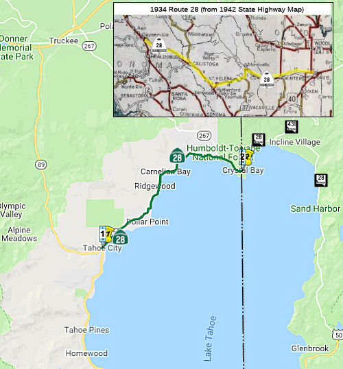 From Route 89 at Tahoe City along the northern boundary of
Lake Tahoe to the Nevada state line at Crystal Bay.
From Route 89 at Tahoe City along the northern boundary of
Lake Tahoe to the Nevada state line at Crystal Bay.
 Post 1964 Signage History
The current definition of Route 28 is unchanged from the 1963 definition.
 Pre 1964 Signage History
 The present-day routing of Route 28 is not the original routing.
In 1934, Route 28 was signed along the route from Jct. Route 1 near Albion
to Jct. US 40 near Davis, vis Sage Canyon. This corresponded to the
following routes:
The present-day routing of Route 28 is not the original routing.
In 1934, Route 28 was signed along the route from Jct. Route 1 near Albion
to Jct. US 40 near Davis, vis Sage Canyon. This corresponded to the
following routes:
In 1952, the original routing for Route 28 was renumbered as Route 128.
The present routing was LRN 39 (defined in 1915), and has been
signed as Route 28 since 1952. Prior to 1952, the route was unsigned. The
Route 28 designation permitted the route along the north shore of Lake
Tahoe between Tahoe City and the California-Nevada boundary to join Nevada
Sign Route 28 at the state line.
 Status
This route continues into Nevada as Nevada 28.
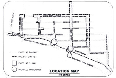
Route 28/Route 267 Roundabout (03-PLA-028 8.9/9.5, 03-PLA-267 9.7/9.898)
In May 2022, the CTC approved for future consideration
of funding the following project: 03-PLA-028 8.9/9.5, 03-PLA-267
9.7/9.898. Kings Beach Western Approach Project. Construct a
roundabout at the intersection of Route 28 and Route 267. (MND) (PPNO
5403) (ATP) Specifically, the Project will construct a roundabout at the
intersection of Route 28 and Route 267. The project also includes the
reconfiguration of an existing midblock crosswalk and a road diet on
adjacent portions of Route 28 to improve safety.
(Source: May 2022 CTC Agenda, Agenda Item 2.2c.(3))
In June 2023, the CTC authorized the following District
Minor Project financial allocation: $1,250,000. 03-Pla-28 8.9/9.5. PPNO
—; ProjID 0318000146; EA 0C932. In Placer County, on Route 28 in
Kings Beach at the Route 28/Route 267 Intersection. Outcome/Output:
Construct roundabout. This is a substitute project for EA 1J400. Financial
Contribution Only (FCO) to the County of Placer. Future Consideration of
Funding approved under Resolution E-22-32; May 2022.
(Source: June 2023 CTC Agenda, Agenda Item 2.5a #1)
In December 2020, the CTC authorized relinquishment of 03-Pla-28-PM
9.2/10.3, right of way consisting of nonmotorized transportation
facilities, in the county of Placer along Route 28 (North Lake Boulevard)
between Route 267 (North Shore Boulevard) and Chipmunk Street. The County
agreed to waive the 90-day notice requirement and accept title upon
relinquishment by the State under the terms and conditions stated in the
relinquishment agreement dated August 31, 2020.
(Source: December 2020 CTC Agenda, Agenda Item
2.3c)
Kings Beach Commerical Core Project (~ PLA 9.366 to PLA 10.215)
 In 2007, the CTC did not
recommend using the Corridor Mobility Improvement Account to fund the
Kings Beach commercial core.
In 2007, the CTC did not
recommend using the Corridor Mobility Improvement Account to fund the
Kings Beach commercial core.
In June 2012, the CTC approved for future consideration of funding the Kings Beach Commercial Core Improvement Project (project) in Placer County, which will include roadway improvements to Route 28 to accommodate anticipated future transit and pedestrian needs which will include installing sidewalks; constructing curbs, gutters, storm drains, and water quality facilities at specific locations; streetscaping; designating specific road sites as on-street parking; and construction of new, off-street parking lots at specific locations within the action area in Placer County.
 Freeway
[SHC 253.1] Entire route. Added to the Freeway and Expressway system in 1959.
 Scenic Route
[SHC 263.1] Entire route.
 Interregional Route
[SHC 164.11] Entire route.
 Other WWW Links
 Statistics
Overall statistics for Route 28:
 Pre-1964 Legislative Route
The route that would become LRN 28 was first defined in the 1909 First Bond Act as running from Redding to Alturas. It was also part of the "Lassen State Highway" established in 1911 by Chapter 498 as follows:
"That certain highway known as the county road and beginning on the boundary line between Shasta and Lassen Counties in the NE corner of T37N R6E and running and extending through T38N R6E, T38N R7E, T38N R8E, to the Modoc County Line...shall be designated and known as the Lassen State Highway"
It was seemingly extended in 1915 when Chapter 765 authorized the survey, location, and construction of a route "from Surprise valley, in Modoc county, to the Nevada state line." However, this authorization was rescinded in the 1935 act that created the state highway code.
In 1921, it was more directly extended with Chapter 888, which provided an appropriation “...for the survey, plans and estimates and for the construction of the highway from the town of Alturas in Modoc county to the Nevada-California state line by the most direct and practical route via Cedarville in connecting with the proposed Nevada state highway...”
By 1935, the route had been codified into the highway code as running "from Redding to the Nevada line via Alturas and Cedarville". It was primary state highway from Redding to Alturus. The 1935 definition remained unchanged until the great renumbering in 1963. The entire route was signed as US 299 between Redding and US 395. The signate E of US 395 to the Nevada border before 1964 was unclear.
© 1996-2020 Daniel P. Faigin.
Maintained by: Daniel P. Faigin
<webmaster@cahighways.org>.
 Route 27
 Route 29