
 California Highways:
Click here for a key to the symbols used. An explanation of acronyms may be found at the bottom of the page.
 Routing
 Post 1964 Signage History
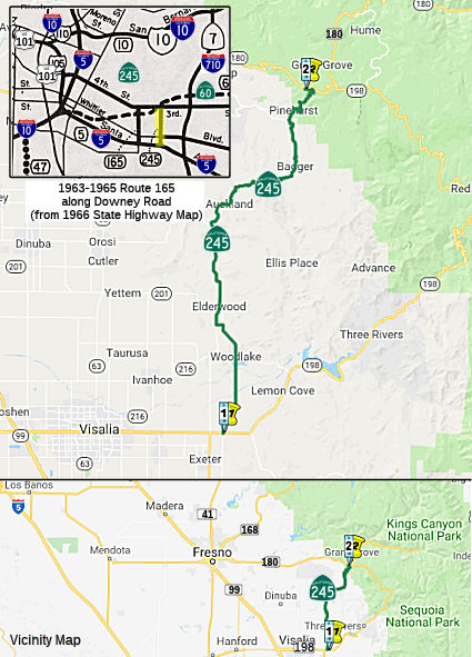
 In 1963, Route 245 was defined as the route from "Route 5 near Los Angeles to Route 60 at the
intersection of Downey Road." This may have been a temporary routing
related to construction of the downtown interchanges.
In 1963, Route 245 was defined as the route from "Route 5 near Los Angeles to Route 60 at the
intersection of Downey Road." This may have been a temporary routing
related to construction of the downtown interchanges.
Route 245 entered the State Highway System during 1933 as part of LRN 166, which was defined as "Los Angeles, Indiana and 3rd Streets to the Huntington Beach-Whittier Road near Santa Fe Springs". In 1935, this was added to the highway code as LRN 166 with the definition:
"[LRN 172], at the intersection of Indiana and Third Streets, in Los Angeles, to [LRN 171] near Sante Fe Springs"
This route, as originally defined, would likely have run down from 3rd St (LRN 172) and Indiana St and then across Telegraph Road (the future I-5 routing) perhaps as far as Buena Park, where it met a routing of Route 39, which was LRN 171. The routing started out as US 101 Bypass, and later became I-5.
In 1941, Chapter 142 changed both endpoints, making the route from "[LRN 172] at the intersection of Downey Road Indiana and
Third Streets, in Los Angeles, to LRN 174 near Norwalk
[LRN 171] near Sante Fe Springs". Downey Road is the
short-lived post-1964 Route 245. This led to a change in LRN 173, which
was adjusted to end at Downey Road instead of Indiana Street. That change
also removed Indiana Street from the state highway system (briefly). After
this change, the route ran from LRN 172 (3rd Street, eventual Route 60) at the
intersection of Downey Road to former Route 42 (LRN 174) near Norwalk.
This included the segment of 1964-1965 Route 245 along Downey Road between
Route 60 (LRN 172) and US 101, and the segment of US 101 (freeway routing)
from Downey Road to LRN 174 (intersection with former Route 42). This was
reflective of the creation of the US 101 Bypass Freeway.
In 1947, Indiana St was added back to the State Highway System, this time
as LRN 230. It ran between Olympic/9th and 3rd. That
changed in 1957, when Chapter 36 changed the terminus of LRN 173: "…
to [LRN 166] near Downey Road [LRN 2] near Soto Street".
This change made Olympic/9th St. between Soto St and Indiana
part of LRN 230 (although no change was needed in the legislative
definition). In the 1964 renumbering, LRN 230 became short-lived Route 165, LRN 173 became the Santa Monica Freeway, and the US 101 Bypass
portion of LRN 166 became I-5 (connecting with the new freeway version of
LRN 2).
So why was LRN 166 created in the first place? It was likely to connect
Sign Route 26 (LRN 173) with the new road to Pomona (LRN 172) and
Telegraph Road to points S, and later as a connection between LRN 174 and
the US 101 Bypass. Why did it become Route 245? There were likely two
reasons: (1) to provide a route to connect to old US 101 (what became
Route 72), and to provide a connection between US 101 Bypass/I-5 and the
new Route 60 until the interchange was completed.
(Source: DPF Research, triggered by the original version of
Gribblenation Blog (Tom Fearer), "The first California State Route 245", 6/20/2023)
In 1965, Chapter 1372 deleted that routing.
In 1972, Chapter 1216 redefined Route 245 as
"Route 198 to Route 180 near the General Grant Grove section of Kings
Canyon National Park." This route was created as a renumbering of former
Route 69. Rumor has it that the renumbering was due to continual theft of the Route 69
signs.
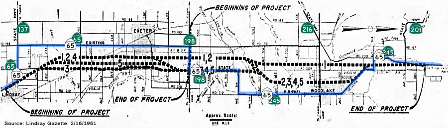 In 1961, studies of proposed alternate routes for the
Route 65 expressway extension N from Lindsay to the vicinity of Woodlake
were presented. The segment would run from Ave. 228 in Lindsay to Ave 384,
about 4 mi N of Woodlake. Three alternate routes are proposed, all of
which would relocate the present route. There would also be some
adjustments to Route 198 where it intersects the project. The initial plan
is to provide a 4-lane expressway from Lindsay to Route 198 (with the
possibility of an eventual 6-lane freeway). N of Route 198, the plan is
for a 2-lane expressway. Route 198 would get an interchange with Route 65,
and a 4-lane expressway W to tie in with the E city limits of Visalia and
Road 192. Based on the subsequent rescinding of the segment of Route 245
between Route 198 and 1 mi N of Route 201, it looks like proposal 2 was
adopted but never constructed. The portion of the existing Route 65 N of
Route 198 is now Route 245 (nee Route 69)
In 1961, studies of proposed alternate routes for the
Route 65 expressway extension N from Lindsay to the vicinity of Woodlake
were presented. The segment would run from Ave. 228 in Lindsay to Ave 384,
about 4 mi N of Woodlake. Three alternate routes are proposed, all of
which would relocate the present route. There would also be some
adjustments to Route 198 where it intersects the project. The initial plan
is to provide a 4-lane expressway from Lindsay to Route 198 (with the
possibility of an eventual 6-lane freeway). N of Route 198, the plan is
for a 2-lane expressway. Route 198 would get an interchange with Route 65,
and a 4-lane expressway W to tie in with the E city limits of Visalia and
Road 192. Based on the subsequent rescinding of the segment of Route 245
between Route 198 and 1 mi N of Route 201, it looks like proposal 2 was
adopted but never constructed. The portion of the existing Route 65 N of
Route 198 is now Route 245 (nee Route 69)
(Source: Lindsay Gazette, 2/16/1961, via Joel Windmiller, 2/26/2023)
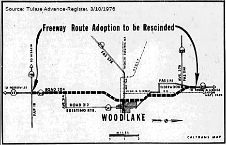 In 1976, the CHC published a notice of intent to rescind the freeway route adoption of
Route 245 between Route 198 and 1 mi N of Route 201. The segments were
adopted in 1962 and 1965.
In 1976, the CHC published a notice of intent to rescind the freeway route adoption of
Route 245 between Route 198 and 1 mi N of Route 201. The segments were
adopted in 1962 and 1965.
(Source: Tulare Advance-Register, 3/10/1976 via Joel Windmiller)
 Pre 1964 Signage History
The 1964-1965 incarnation of Route 245 was part of LRN 166.
The post-1972 incarnation of Route 245 was originally part of Route 65, and was renumbered as Route 69 when a new alignment was proposed for Route 65 in 1964. In 1972, it was renumbered again as Route 245. This was part of LRN 129, defined in 1933.
Note that, prior to 1940, Route 180 was along Dunlap Road, and thus Route 65 (now Route 245) terminated at Dunlap Road.
 Status
Yokohl Creek / Kaweah River Bridges (06-Tul-245 PM 1.19/1.59, 4.19/4.30)
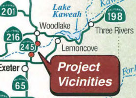 In October 2019, the CTC had on its agenda for future consideration of the following project:
06-Tul-245, PM 1.26/4.19 Route 245 in Tulare County. Replace existing
bridge on Route 245 near the town of Woodlake in Tulare County. (PPNO
6787). This project is located on Route 245 near Woodlake in Tulare
County. The project proposes to replace the nonstandard bridges with
standard width bridges and install standard approach railing as needed at
both Yokohl Creek bridge (No. 46-0011) at post mile 1.39, and at Kaweah
River bridge (No. 46-0073) at post mile 4.19. This project is fully funded
and is currently programmed in the 2018 State Highway Operation Protection
Program (SHOPP) for an estimated $17.3 million which includes Plans,
Specifications and Estimates, Construction (capital and support) and Right
of Way (capital and support). Construction is estimated to begin in 2021.
The scope, as described for the preferred alternative, is consistent with
the project scope programmed by the California Transportation Commission
(Commission) in the 2018 SHOPP.
In October 2019, the CTC had on its agenda for future consideration of the following project:
06-Tul-245, PM 1.26/4.19 Route 245 in Tulare County. Replace existing
bridge on Route 245 near the town of Woodlake in Tulare County. (PPNO
6787). This project is located on Route 245 near Woodlake in Tulare
County. The project proposes to replace the nonstandard bridges with
standard width bridges and install standard approach railing as needed at
both Yokohl Creek bridge (No. 46-0011) at post mile 1.39, and at Kaweah
River bridge (No. 46-0073) at post mile 4.19. This project is fully funded
and is currently programmed in the 2018 State Highway Operation Protection
Program (SHOPP) for an estimated $17.3 million which includes Plans,
Specifications and Estimates, Construction (capital and support) and Right
of Way (capital and support). Construction is estimated to begin in 2021.
The scope, as described for the preferred alternative, is consistent with
the project scope programmed by the California Transportation Commission
(Commission) in the 2018 SHOPP.
(Source: October 2019 CTC Agenda, Agenda Item
2.2c.(1))
In October 2019, the CTC approved the following
pre-construction allocation: 06-Tul-245 1.4. PPNO 6787 Proj ID 0615000293
EA 0U280. Route 245 Near Woodlake, at Yokohl Creek Bridge No. 46-0011 (PM
1.39); also at Kaweah River Bridge No. 46-0073 (PM 4.19). Replace bridges
to upgrade to current standards, facilitate bike lane shoulders, and
upgrade guard railing. (Concurrent consideration of funding under
Resolution E-19-93; October 2019.) PS&E $2,260,000 (Programmed)
$2,486,000 (Allocated) R/W Sup $645,000
(Source: October 2019 CTC Agenda, Agenda Item
2.5b.(2b) #7)
In January 2020, the CTC approved a technical amendment
to the 2018 SHOPP regarding this project: 06-Tul-245 1.4 1.2/1.6
PPNO 6787 ProjID 0615000293 EA 0U280. Route 245 near Woodlake, at Yokohl
Creek Bridge No. 46-0011 (PM 1.39 1.19/1.59); also
at Kaweah River Bridge No. 46-0073 (PM 4.19/4.30). Replace
bridges to upgrade to current standards, facilitate bike lane shoulders,
and upgrade guard railing. The amendment included an increase to
construction cost because of an increase in bridge material costs, the
need for temporary trestles to facilitate pile driving, and the need to
raise the bridge profile in order to meet updated Central Valley Flood
Protection Board (CVFPB) requirements. Increase to construction support
because more working days are required. There was a decrease in R/W
capital because environmental mitigation and utility costs were lower than
expected.
(Source: January 2020 CTC Agenda, Agenda Item
2.1a.(1d) Item 17)
The 2020 SHOPP, approved in May 2020, included the
following Bridge Preservation item of interest (carried over from the 2018
SHOPP): 06-Tulare-245 PM 1.2/1.6 PPNO 6787 Proj ID 0615000293 EA 0U280.
Route 245 near Woodlake, at Yokohl Creek Bridge No. 46-0011 (PM
1.19/1.59); also at Kaweah River Bridge No. 46 -0073 (PM 4.19/4.30).
Replace bridges to upgrade to current standards, facilitate bike lane
shoulders, and upgrade guardrailing. Programmed in FY20-21, with
construction scheduled to start in October 2021. Total project cost is
$25,910K, with $18,280K being capital (const and right of way) and $7,630K
being support (engineering, environmental, etc.).
(Source: 2020 Approved SHOPP a/o May 2020)
In August 2021, the CTC approved the following
construction phase allocation: $15,687,000. 06-Tul-245 1.19/1.59. PPNO
06-6787; ProjID 0615000293; EA 0U280. Route 245 Near Woodlake, at Yokohl
Creek Bridge № 46-0011; also at Kaweah River Bridge № 46-0073
(PM 4.19/4.30). Outcome/Output: Replace bridges to upgrade to current
standards, facilitate bike lane shoulders, and upgrade guard rail.
Allocation (some from other sources): CON ENG $3,400,000 CONST
$18,000,000. (Future consideration of funding approved under Resolution
E-19-93; October 2019.) (Six month time extension for CONST and CON ENG
approved under Waiver 21-59; June 2021.)
(Source: August 2021 CTC Agenda, Agenda Item
2.5b.(1) #35)
Lindsay Route 65 and Route 198/245 Operational Improvements Project (06-Tul-65, 29.0/R30.4; 06-Tul-198, R19.5/20.0; 06-Tul-245, 0.0/0.2)
There are also plans to construct a new expressway in Lindsey.
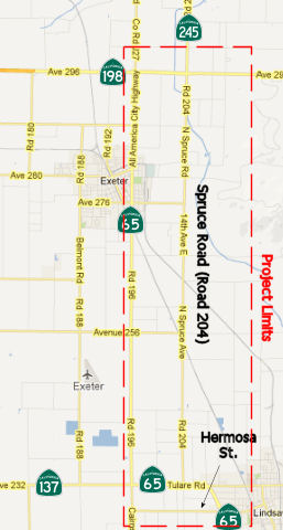 In December 2012,
the CTC reviewed a draft EIR regarding improvements on Route 65 and Route 245 in Tulare County to create the Tulare Expressway. The project will
realign Route 65 and construct a two-lane expressway on a four-lane right
of way for 9.3 miles from Hermosa Street in Lindsay to Avenue 300 on Route 245 northeast of Exeter (~ TUL 29.469 to TUL 39.539, 198 TUL R18.845 to
TUL R19.74, 245 TUL 0.000 to 245 TUL 0.514). There would also be about 0.5
miles of improvements on Route 245 starting at Route 198. The project is
not fully funded. The project is programmed in the 2012 State
Transportation Improvement Program. The total estimated cost for capital
and support is $102,711,000. Construction is estimated to begin in Fiscal
Year 2018-19. In addition to the no-build alternatives, there are two
alternatives being considered: Build Alternative 1 would parallel
the east and west side of existing Spruce Avenue depending on location; Build
Alternative 2 would project the west side of existing Spruce Avenue.
The project is needed to provide a continuous expressway through the
corridor. Existing Route 65 does not provide direct access to Route 245
for traffic wishing to continue NB. Currently NB traffic on Route 65 must
turn E at the Route 65/Route 198 intersection, enter a left turn lane, and
wait for a signal. Route 65 also passes through Exeter, resulting in
traffic flow interruptions with local traffic and the use of Spruce Road
(Road 204) as an alternative. This has increased the accident rate.
In December 2012,
the CTC reviewed a draft EIR regarding improvements on Route 65 and Route 245 in Tulare County to create the Tulare Expressway. The project will
realign Route 65 and construct a two-lane expressway on a four-lane right
of way for 9.3 miles from Hermosa Street in Lindsay to Avenue 300 on Route 245 northeast of Exeter (~ TUL 29.469 to TUL 39.539, 198 TUL R18.845 to
TUL R19.74, 245 TUL 0.000 to 245 TUL 0.514). There would also be about 0.5
miles of improvements on Route 245 starting at Route 198. The project is
not fully funded. The project is programmed in the 2012 State
Transportation Improvement Program. The total estimated cost for capital
and support is $102,711,000. Construction is estimated to begin in Fiscal
Year 2018-19. In addition to the no-build alternatives, there are two
alternatives being considered: Build Alternative 1 would parallel
the east and west side of existing Spruce Avenue depending on location; Build
Alternative 2 would project the west side of existing Spruce Avenue.
The project is needed to provide a continuous expressway through the
corridor. Existing Route 65 does not provide direct access to Route 245
for traffic wishing to continue NB. Currently NB traffic on Route 65 must
turn E at the Route 65/Route 198 intersection, enter a left turn lane, and
wait for a signal. Route 65 also passes through Exeter, resulting in
traffic flow interruptions with local traffic and the use of Spruce Road
(Road 204) as an alternative. This has increased the accident rate.
In November 2016, it was reported that the CTC/Caltrans
had “withdrawn from further consideration” its 2012 plan to
realign Route 65 between Exeter and Lindsay. Project Manager Judy
Aguilar-Luna said the project was being discontinued for a lack of funding
through the State Transportation Improvement Program. Instead Aguilar-Luna
said Caltrans will begin studying “essential improvements”
along the route. She said these will most likely be smaller projects that
can be completed one at a time, such as improving the intersection of
Route 245 and Route 198 near Exeter or changes to the intersections of
Hermosa Street and Oak Avenue along Route 65 in Lindsay. The decision to
stop the project is good news for Lindsay businesses that front the
current alignment of Route 65. Caltrans’ initial plan proposed
realigning Route 65 more closely with Spruce Road (Road 204) and away from
its current route along Road 196 (Kaweah204) and away from its current
route along Road 196 (Kaweah Avenue through Exeter). As part of the
realignment, the current highway would have become a frontage road and the
new highway would have been moved farther west away from the City and
businesses. The City of Lindsay became the first public agency to formally
oppose the Route 65 plan when the City Council approved a letter at its
July 9 meeting over concerns for its highway-adjacent businesses. In the
letter, then City Planner Bill Zigler stated the “awkwardly
configured frontage road” would provide little economic help to the
businesses north of the intersection of Hermosa. The city countered the
plan by proposing a Lindsay exit at Lindmore. The exit would have created
a one-way northbound frontage road along the current highway where it
splits into the new alignment and curves west away from the city. This
would have allowed vehicles to access the affected businesses. North of
Hermosa Street, the frontage road would became two lanes and connect to
the Oak Avenue extension, which was already part of initial project. It
would have also created new opportunities for the City to develop
commercial property that would have faced the new highway. And because
most of the land running along the west side of the current highway
already falls within Lindsay’s urban develop boundaries, the new
highway frontage would have been within the city’s sphere of
influence. The city later withdrew its own proposal after Caltrans said it
would have to condemn all of the properties (both homes and businesses
such as the 76 Station) on the west side of the freeway because Freemont
Drive would have created a dead-end road that exceeded the maximum length
set by the State. Transforming the current highway into a one-way,
northbound “Lindsay Exit” would have required making Fremont
Drive a cul-de-sac at the southern end near Lindmore. There is no
timetable to present the three-phase plan to make improvements along the
route. Once completed, Caltrans will circulate a new draft environmental
document for the replacement project. The draft document will be available
for review at an open forum public hearing and public notice will provided
for new comments.
(Source: Foothills Sun-Gazette, 11/9/2016)
The 2018 STIP, approved at the CTC March 2018 meeting, appears to adjust the allocation for PPNO 0104 Align Rd 204, Rt 65-Rt 198, 4 lanes, TUL 29.5/38.6. Near the city of Tulare, on Route 65 from Lindsay to Exeter, and on Road 204 from Route 137 to Route 198. Widen to 4 divided lanes and realign highway. The 2018 STIP changes the allocation from $3.150M to $5.650M.
The 2020 STIP, approved at the March 2020 CTC meeting,
continues the programming for PPNO 0104 Realignment & Operational
Improvements: $5,650K in prior years. It also adds a new PPNO 0104A
Realign & Op imprvmts (Oak St Roundabout), Phase 1, with programmed
funding of $1,500K in FY23-24.
(Source: March 2020 CTC Agenda, Item 4.7, 2020 STIP
Adopted 3/25/2020)
In March 2026, the CTC adopted the 2026 STIP, which
included the following as continued programming from 2024: PPNO 06-0104,
“Realignment & Operational Improvements”. Total Programmed
($×1000): $5,650. Prior years programming ($×1000): $5,650. 2026
and Future Programming ($×1000): $0. Programming Breakdown
($×1000): $5,650 (PA&ED), $0 (PS&E), $0 (Const), $0 (Con
Sup), $0 (R/W), $0 (R/W Sup).
(Source: March 2026 CTC Agenda, Agenda Item 4.4; 2026 STIP Staff Recommendations Adopted 2/27/2026)
In March 2026, the CTC adopted the 2026 STIP, which
included the following as continued programming from 2024: PPNO 06-0104A,
“Realign & Op imprvmts (Oak St Roundabout), Phase 1”.
Total Programmed ($×1000): $22,650. Prior years programming
($×1000): $2,500. 2026 and Future Programming ($×1000): $20,150
FY27-28. Programming Breakdown ($×1000): $0 (PA&ED), $2,500
(PS&E), $17,200 (Const), $2,950 (Con Sup), $0 (R/W), $0 (R/W Sup).
(Source: March 2026 CTC Agenda, Agenda Item 4.4; 2026 STIP Staff Recommendations Adopted 2/27/2026)
In June 2026, the CTC approved for future consideration
of funding the Lindsay Route 65 and Route 198/245 Operational
Improvements Project: Route 65, Route 198, and Route 245 in Tulare
County. Make operational improvements on Route 65 from PM 29.0 to R30.4,
Route 198 from PM R19.5 to 20.0, and Route 245 from PM 0.0 to 0.2, in
Tulare County. Specifically, the project includes, in the City of Lindsay,
construction of a roundabout on Route 65 near Tulare Road, realignment of
Route 65 from Avenue 224 (Lindmore Street) to just east of Cedar Avenue,
and construction of roundabouts on the new alignment at Hermosa Street and
the Route 65 connection; near the City of Exeter, the project includes
construction of a roundabout at the junction of Route 198 and Route 245. (06-Tul-65,
29.0/R30.4; 06-Tul-198, R19.5/20.0; 06-Tul-245, 0.0/0.2; PPNO 06-0104A).
The project is currently programmed in the 2026 State Transportation
Improvement Program (STIP) and the Senate Bill 1 Local Partnership Program
for Plans, Specifications and Estimate, Right of Way (Support and Capital)
and Construction (Support and Capital) for $28,405,000. Construction will
begin in 2027-28. The scope, as described for the preferred alternative,
is consistent with the project scope as programmed by the Commission in
the 2026 STIP. The project will result in less than significant impacts to
the environment.
(Source: June 2026 CTC Agenda, Agenda Item 2.2c.(1) #2)
In June 2026, the CTC approved a request for an
additional $105,000 for the Route 65 Realignment & Operational
Improvements (Oak St Roundabout), Location 1 Phase I project to complete
the Plans, Specifications, and Estimate (PS&E) phase. The project
proposes to construct a roundabout. The project realized cost increases
due to additional design work that is required for proposed scope. A
project change request has been submitted and is pending approval.
It proposes to increase the project limits to tie into the existing
pavement at a more suitable location; and revise the scope by adding two
drainage basins, incorporating sidewalk improvements, additional
landscaping requested by the City, expanding utility relocation limits to
meet the Lindmore Irrigation District’s requirements, and adding an
enhanced median per the recommendation from the Department’s Traffic
Operations office. These changes will make for a better project and
minimize disruptions caused by having multiple projects.
(Source: June 2026 CTC Agenda, Agenda Item 2.5s.(16))
$105,000. 06-Tul-65 29.7 29.6/30.3.
PPNO 06-0104A; ProjID 0620000059; EA 43081. SR 65 Realignment &
Operational Improvements (Oak St Roundabout), Location 1 Phase I.
Construct a roundabout In Lindsay from 0.1 mile south of Mariposa St. to
Cedar Ave. Supplemental funds are needed to complete PS&E. CEQA - ND,
12/07/2023; Re-validation 05/07/2025 NEPA - EIS, 12/07/2023; Re-validation
05/07/2025. Concurrent consideration of funding under Resolution E-26-32;
June 2026. Concurrent LPP (Formulaic) Programming Amendment under
Resolution LPP-P-2526-17; June 2026. Contribution from other sources:
$1,195,000. Breakdown: PS&E $2,500,000 + $105,000 = $2,605,000.
The following project was included in the final adopted 2018 SHOPP in March 2018: PPNO 6787. 06-Tulare-245 1.4. Route 245 Near Woodlake, at Yokohl Creek Bridge No. 46-0011 (PM 1.39); also at Kaweah River Bridge No. 46-0073 (PM 4.19). Replace bridges to upgrade to current standards, facilitate bike lane shoulders, and upgrade guard railing. Begin Con: 10/5/2021. Total Project Cost: $18,665K.
Caltrans is exploring creating a roundabout on this route at the intersection of Route 216/Route 245 in Woodlake (~ TUL 7.054). Other potential/planned roundabout locations in the San Joaquin Valley include Route 145/Jensen near Kerman, Route 168/Auberry Road in Prather, Route 43/Route 137 in Corcoran, Route 190/Road 152 east of Tipton, Route 190/Road 284 east of Porterville, and Route 155/Browning Road in Delano. A 2007 study of 55 roundabouts in the U.S. found a 35% reduction in accidents and a 90% reduction in fatal accidents when intersections with stop signs or signals were converted to roundabouts. It costs about the same to build a roundabout as to put up traffic signals, and they need significantly less maintenance than traffic signal intersections -- about 60% to 90% less, depending on how much landscaping work is required.
 Naming
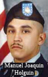 The portion of Route 245 (Millwood Drive) from Avenue 364 to Avenue 398 near
the town of Elderwood (~ TUL 10.47 to TUL 14.97), in the County of Tulare,
is named the "Specialist Manuel Joaquin Holguin Memorial Highway".
It was named in memory of United States Army Specialist Manuel Joaquin
Holguin, born in 1984 in Visalia, California. Joaquin, as he was known to
his family, grew up in the small foothill community of Elderwood,
California, and attended public schools in Woodlake, California,
graduating from Woodlake Union High School in June 2002. Joaquin was an
athlete, playing soccer and baseball from the age of 5 years through high
school. Living in the country, he also became knowledgeable in the use and
safe handling of firearms and by the age of 12 years, he passed his hunter
safety course and was proficient with a 12-gauge shotgun. In the fall of
2001, Joaquin decided to join the United States Army, following in the
footsteps of his grandfather and uncles who had served in the United
States Army during World War II and the Vietnam War. During his senior
year of high school, Joaquin was admitted into the United States
Army’s early enlistment program, officially enlisting upon
graduation from high school for a three-year commitment on November 11,
2002, and was sent to Fort Benning, Georgia, for boot camp. Joaquin
remained at Fort Benning, Georgia, for advanced infantry training,
graduating in March 2003 with a designation as a mortarman. He also earned
an award for being the highest marksman with a rifle in his platoon and
would go on to continually score as an expert with a rifle and mortar.
Joaquin was assigned as a gunner and driver to the 2nd Battalion, 6th
Infantry Regiment, 2nd Brigade of the 1st Armored Division in Baumholder,
Germany. His division left Germany for Iraq in April 2003 and was assigned
to an area of southern Baghdad operating out of Camp Muleskinner, but also
saw action in Karbala and Al-Kut. His division would remain in Iraq for 15
months before returning to Germany, during which time, in this his first
tour of duty, Joaquin received the Combat Infantry Badge and earned the
rank of Specialist. Joaquin received orders that his active duty
commitment was being extended. In November 2005, his brigade was sent back
to the area of southern Baghdad Iraq for a second one-year tour of duty,
and Joaquin volunteered to be part of the advanced detachment whose job
was to get things in order for the arrival of the remainder of the
brigade. On July 15, 2006, his unit, doing mounted and foot patrols,
responded to an explosion at a marketplace, set up a perimeter, and began
to receive small arms fire. During the firefight, an improvised explosive
device (IED) detonated, killing Joaquin and severely wounding another
soldier. Joaquin died one month before his 22nd birthday and three months
before his tour of duty would have been completed. Joaquin was awarded the
Purple Heart and the Bronze Star Medals for his active military service in
the United States Army for his actions, not only on that day, but for the
entire time he spent in Iraq. Joaquin was also awarded the Army
Commendation Medal with Oak Leaf Cluster, the Army Good Conduct Medal, the
National Defense Service Medal, the Army Service Ribbon, the Overseas
Service Ribbon, the Iraqi Campaign Medal, the Global War on Terrorism
Expeditionary Medal, and the Presidential Unit Citation Award for his two
tours of duty in Iraq. Named by Assembly Concurrent Resolution 135, Res.
Chapter 85, on July 7, 2014.
The portion of Route 245 (Millwood Drive) from Avenue 364 to Avenue 398 near
the town of Elderwood (~ TUL 10.47 to TUL 14.97), in the County of Tulare,
is named the "Specialist Manuel Joaquin Holguin Memorial Highway".
It was named in memory of United States Army Specialist Manuel Joaquin
Holguin, born in 1984 in Visalia, California. Joaquin, as he was known to
his family, grew up in the small foothill community of Elderwood,
California, and attended public schools in Woodlake, California,
graduating from Woodlake Union High School in June 2002. Joaquin was an
athlete, playing soccer and baseball from the age of 5 years through high
school. Living in the country, he also became knowledgeable in the use and
safe handling of firearms and by the age of 12 years, he passed his hunter
safety course and was proficient with a 12-gauge shotgun. In the fall of
2001, Joaquin decided to join the United States Army, following in the
footsteps of his grandfather and uncles who had served in the United
States Army during World War II and the Vietnam War. During his senior
year of high school, Joaquin was admitted into the United States
Army’s early enlistment program, officially enlisting upon
graduation from high school for a three-year commitment on November 11,
2002, and was sent to Fort Benning, Georgia, for boot camp. Joaquin
remained at Fort Benning, Georgia, for advanced infantry training,
graduating in March 2003 with a designation as a mortarman. He also earned
an award for being the highest marksman with a rifle in his platoon and
would go on to continually score as an expert with a rifle and mortar.
Joaquin was assigned as a gunner and driver to the 2nd Battalion, 6th
Infantry Regiment, 2nd Brigade of the 1st Armored Division in Baumholder,
Germany. His division left Germany for Iraq in April 2003 and was assigned
to an area of southern Baghdad operating out of Camp Muleskinner, but also
saw action in Karbala and Al-Kut. His division would remain in Iraq for 15
months before returning to Germany, during which time, in this his first
tour of duty, Joaquin received the Combat Infantry Badge and earned the
rank of Specialist. Joaquin received orders that his active duty
commitment was being extended. In November 2005, his brigade was sent back
to the area of southern Baghdad Iraq for a second one-year tour of duty,
and Joaquin volunteered to be part of the advanced detachment whose job
was to get things in order for the arrival of the remainder of the
brigade. On July 15, 2006, his unit, doing mounted and foot patrols,
responded to an explosion at a marketplace, set up a perimeter, and began
to receive small arms fire. During the firefight, an improvised explosive
device (IED) detonated, killing Joaquin and severely wounding another
soldier. Joaquin died one month before his 22nd birthday and three months
before his tour of duty would have been completed. Joaquin was awarded the
Purple Heart and the Bronze Star Medals for his active military service in
the United States Army for his actions, not only on that day, but for the
entire time he spent in Iraq. Joaquin was also awarded the Army
Commendation Medal with Oak Leaf Cluster, the Army Good Conduct Medal, the
National Defense Service Medal, the Army Service Ribbon, the Overseas
Service Ribbon, the Iraqi Campaign Medal, the Global War on Terrorism
Expeditionary Medal, and the Presidential Unit Citation Award for his two
tours of duty in Iraq. Named by Assembly Concurrent Resolution 135, Res.
Chapter 85, on July 7, 2014.
(Image source: Iraq/Afghanistan War Heroes)
 National Trails
 The portion of this route between Route 99 and Kings Canyon
National Park was part of the National Park to Park Highway.
The portion of this route between Route 99 and Kings Canyon
National Park was part of the National Park to Park Highway.
 Other WWW Links
 Statistics
Overall statistics for Route 245:
 Pre-1964 Legislative Route
In 1959, Chapter 1062 defined LRN 245 as “[LRN 232] near Catlett to [LRN 87] near Tudor”. This route runs from Route 24 (present-day Route 70) near Catlett to Alternate US 40 (present-day Route 99) near Tudor. This is part of present-day Route 99.
© 1996-2024 Daniel P. Faigin.
Maintained by: Daniel P. Faigin
<webmaster@cahighways.org>.
 From Route
  Route 244
 Route 246