
 California Highways:
Click here for a key to the symbols used. An explanation of acronyms may be found at the bottom of the page.
 Routing
 Post 1964 Signage History
▸ As defined in 1963, this routing was defined as "(a) Route 10 near Pomona to Route 91 via Pomona. (b) Route 91 to Route 395. (c) Route 395 near Temecula to Route 74 east of Anza."
▸ In 1968, Chapter 282 changed the northern end of (a) to be Route 210 (which, at this time, was the current Route 57/I-10 junction).
▸ In 1969, Chapter 294 changed the references to Route 395 to Route 15.
▸ In 1974, Chapter 537 deleted segments (b) and (c). Segment (b) was transferred to Route 15, and (c) was transferred to Route 79 (from Route 15 to Route 79 near Aguanga) and to Route 371 (from Route 79 to Route 74).
With respect to the transfer of Route 71 to Route 79 from County Sign Route R3 to
Temecula, Scott Parker on AARoads noted: The adoption of Route 79 along
Winchester Road threw the area's highway network into chaos -- and this
was before I-15 (and I-215) were even on the scene. The Division of
Highways had recently brought the connector from Route 79 near Aguanga
northeast to Route 74 (i.e., originally part of Route 71, now Route 371)
into the state system as a "shortcut" from the San Diego area to Coachella
Valley cities. Without it, Route 71 would have simply been truncated to
end at Murietta, north of Temecula (at the site of the present 15/215
split) -- but D8 chose to multiplex Route 71 and Route 79 together for
about 20 miles total to Aguanga, where Route 71 struck out over the new
route NE to Route 74 (which was a bit awkward, as Route 71 and Route 74
then intersected one another twice, at Elsinore and near Anza). This
arrangement lasted all of 8 years; after it was decided to route I-15 down
Route 71 from Corona south to Temecula. So, in 1974, D8 simply truncated
Route 71 at the (then) US 395 junction in Murietta, leaving Route 79 as
the sole occupant of the Temecula-Aguanga route; the Anza connector was
redesignated as Route 371. This happened at the same time as the
commissioning of Route 330 due to the reroute of CA 30 away from the San
Bernardino mountains and over to Redlands -- so a 300-series number wasn't
an isolated case. Of course, when I-15 was completed south of Corona,
Route71 was cut back to its Corona-Pomona section, and US 395 was cut back
to I-15 at Hesperia, with, first, I-15E and after 1982 I-215 taking over
its routing. But today that relatively short (about 3 mile) section of
I-15 multiplexed with CA 79 in Temecula is one of the most congested
locations in the Inland Empire; and both adjacent sections of CA 79 itself
-- relinquished or not -- are the two most heavily developed commercial
"strips" in the area.
(Source: Scott Parker on AARoads, "Re: CA 79", 10/30/2019)
▸ In 1994, Chapter 1220 clarified the definition to terminate at "Route 91 via Pomona and Chino Hills."
▸ In 2010, Chapter 421 (9/29/10, SB 1318) clarified the definition to start at Route 57 as opposed to Route 210.
 Pre 1964 Signage History
The original routing of Route 71 (which included the current routing) was from US 80 (now I-8) in San Diego to US 66 near Claremont via Elsinore and Temecula. The 1934 signed route definition was Jct. US 80 near San Diego to Jct. US 66 near Claremont, via Elsinore and Temecula. In October 1935, it was noted that the segment of Route 71 along the San Diego to San Bernardino route had been resigned as US 395. It can be broken into the following segments:
As LRN 240 was under construction, Sign Route 71 was also retained on its original routing on Garey Avenue via the original LRN 77 and LRN 19. This was part of the original 1909 definition of LRN 19.
Sign Route 71 was announced as one of the original Signed State Routes in
the August 1934 California Highways & Public Works. Sign Route 71 originated at US 66 near Claremont and followed LRN 19 south towards
Pomona. From Pomona, Sign Route 71 followed the entirety of LRN 77
to US 80 near San Diego.
(Source: Gribblenation Blog (Tom Fearer), "California State Route 71", 11/5/2023)
The California Highway Commission during 1934 submitted a request to the
American Association of State Highway Officials (AASHO) to extend US 395
into the state with a terminus in San Diego. This request was
subsequently approved by the AASHO Executive Commitee. On September
6, 1934, the California Highway Commission submitted their official
routing of US 395 to AASHO. From Elsinore south to San Diego the
alignment of US 395 absorbed what was Sign Route 71 and LRN 77. This
made the terminus of the route US 395 in Temecula.
(Source: Gribblenation Blog (Tom Fearer), "California State Route 71", 11/5/2023)
By 1935, Sign Route 71 followed Garey Avenue along LRN 19 south from US 66/LRN 9 in Claremont to US 99/US 60/US 70/LRN 26 at Holt Avenue in
Pomona. Sign Route 71 briefly multiplexed US 60/LRN 19 on Garey
Avenue south to 5th Street where the latter split east towards
Riverside. Sign Route 71 transitioned onto LRN 77 following Garey
Avenue and Philadelphia Street to the San Bernardino County line. Sign
Route 71 entered San Bernardino County via Eli Street and quickly turned
south towards Corona via Pipeline Avenue. Sign Route 71 skirted the
city limit of Corona via Chino Avenue and Ramona Avenue. South of
Chino, Sign Route 71 intersected LRN 177 at Merrill Avenue (now Chino
Hills Parkway). From LRN 177, Sign Route 71 followed Merill Avenue,
Central Avenue, El Prado Road, Pine Avenue and Pioneer Avenue to Chino
Road in Riverside County. Much of Pioneer Avenue has since been
abandoned or razed within what is now El Prado Regional Park.
In Riverside County, Sign Route 71 was concurrent with LRN 77.
Sign Route 71 followed Chino Road to Sign Route 18/LRN 43 (now Route 91,
and the terminus of Route 71).
(Source: Gribblenation Blog (Tom Fearer), "California State Route 71", 11/5/2023)
Sign Route 71 then multiplexed Sign Route 18 along Pomona-Rincon Road and
6th Street into downtown Corona. Sign Route 71 split
south from Sign Route 18 in downtown Corona via Main Street. Sign
Route 71 south of Corona followed Ontario Avenue, Temescal Canyon Road,
Lake Street and Lakeshore Drive to Sign Route 74/LRN 64 at Riverside Drive
near Elsinore. It is likely Sign Route 71 originally multiplexed
Sign Route 74 in Elsinore to US 395/Main Street via Lakeshore Drive and
Graham Avenue.
(Source: Gribblenation Blog (Tom Fearer), "California State Route 71", 11/5/2023)
By 1937, Sign Route 71/LRN 77 south of Pomona bypassed Chino via an
extension of Garey Avenue. The new bypass of Chino tied into Merrill
Avenue south of the city of limit of Chino directly towards LRN 177.
In 1939, Sign Route 71 and Sign Route 18 required realignment near the
site of Prado Dam within the Santa Ana River Canyon. The existing
alignment of both highways through Prado siding was to be flooded by the
new reservoir. A contract to relocate the routes near the site of
Prado Dam was awarded on January 10, 1939. Later in 1939,
construction on the Pomona Grade Separation started, serving as an
extension of LRN 77 and the new split of US 60 from US 99/US 70/LRN 26. US 60 originally had split from US 99/US 70/LRN 26 multiplexed
with Sign Route 71 via Garey Avenue south to 5th Street in
downtown Pomona. Once completed the Pomona Grade separation had US 60 follow LRN 77 to 5th Street via two railroad overpass
structures. The Pomono Grade Separation opened in 1940; the Prado
Dam relocation was delayed by the war and opened in 1950.
(Source: Gribblenation Blog (Tom Fearer), "California State Route 71", 11/5/2023)
By 1940, Sign Route 71 was extended to Sign Route 79 at Sage Road east of
Temecula, via a multiplex of US 395/LRN 77 from Elsinore to Temecula by
way of Murrieta. From Temecula to east to Sage Road, Sign Route 71
followed LRN 78. The extension of Sign Route 71 seems to have been
driven by Sign Route 79 absorbing the original Sign Route 83 along LRN 194. Originally Sign Route 79 had ended in Temecula via LRN 78. From
Elsinore, Sign Route 71/US 395 multiplexed on Lakeshore Drive, Mission
Trail, Palomar Street and Washington Avenue into Murietta. From
Murietta the multiplexed followed Ivy Street, Jefferson Avenue, and Front
Street to Temecula. From Temecula, Sign Route 71 split from US 395
via LRN 78 along what is now modern Temecula Parkway towards Sage
Road. In 1941, Sign Route 71 in Temescal Canyon was straightened,
due to heavy floods that occurred during March 1938. The
straightened highway was located above the original alignment along less
flood terrain in a 1.67-mile corridor.
(Source: Gribblenation Blog (Tom Fearer), "California State Route 71", 11/5/2023)
In 1953, US 395 was rerouted north of Temecula onto a new cutoff towards Perris. The new alignment of US 395 was constructed as a segment of LRN 78 that bypassed Elsinore. This new alignment removed US 395 from a multiplex with Sign Route 71 between Elsinore and Temecula. Construction of the Temescal Freeway (Route 71, later I-15) began in 1958. This was later renamed the Corona Freeway.
In 1958, Caltrans announced a contract to construct the Temescal Freeway
between 5th Street to 0.9 miles south of Riverside Drive in Pomona, and
was to be constructed as an expressway. This was intended to be a new
alignment for Route 71. This was renamed the Corona Freeway in 1958. With
the completion of the Corona Expressway, the segment of Garey Avenue south
of US 60 to the Corona Expressway was relinquished back to Pomona. This
also created a discontinuity in this section of Sign Route 71: One segment
followed the Corona Expressway routing from Pomona to I-10 along LRN 77
and LRN 240; the other followed the LRN 19 routing between US 60 and
US 66 along Garey. The LRN 19 segment became Route 215 during the 1964
renumbering.
(Source: Gribblenation Blog (Tom Fearer), "Former California State Route 215", 11/10/2023)
In 1960, LRN 277 was adopted. LRN 277 was defined by 1959 Legislative
Chapter 1062 as originating at LRN 78 (Route 79) east of Temecula east to
LRN 64 (Route 74) near Anza. LRN 277 did not have a determined
routing. In 1961, Cahuilla Road was adopted by the California Highway
Commission as LRN 277. LRN 277 was included in the Freeway
& Expressway System. In 1964, this segment became part of Route 71.
(Source: Gribblenation Blog (Tom Fearer), "California State Route 71", 11/5/2023)
The portion of the former routing along Temescal Canyon (roughly current I-15 to Route 79) was part
of the planned Imperial Highway. The name "Imperial" refers to
the Imperial Valley, which took its name from the Imperial Land Co., a
subsidiary of the California Development Company charged with reclaiming
the water-starved but arable land east of San Diego for agricultural
purposes in the early 1900s. The company began building canals in 1900,
diverting water from the Colorado River for irrigation, and forming the
Salton Sea in the process. The Los Angeles area wanted to patch together a
superhighway that would stretch from the Pacific all the way to Brawley in
the Imperial Valley, a distance of 215 miles; the route was later extended
a few miles farther south to El Centro. The most route roughly followed
the old Butterfield Stage overland route, established in 1858: across the
desert (Route 78) and along today’s Route 79 to Temecula, where it
headed on to Corona via Lake Elsinore and Temescal Canyon (Route 71, later
I-15). There the road turned left down the Santa Ana Canyon on its way to
Yorba Linda (present-day Route 91) and La Habra (present-day Route 90),
then across Los Angeles County to meet the sea at El Segundo (as Imperial
Highway, although it is paralleled by I-105). The extension to Brawley was
along Route 86 The early Imperial Highway plans involved connecting a
patchwork assortment of roads of varying length and quality. In
1912, a group of Los Angeles boosters informally known as the Committee of
One Hundred, working with Los Angeles, San Bernardino, Orange, Riverside
and Imperial counties, settled on a route along the edge of the inland
Salton Sea that completely bypassed San Diego County, from which Imperial
County had been split off in 1907. The Los Angeles section of road would
be mostly a straight shot from LAX to Anaheim, where the proposed road
would dip south diagonally before eventually reaching the Imperial Valley.
By the 1920s, the efficacy of the Imperial Highway concept had become
apparent, and a new and more forceful private group, the Imperial Highway
Association, was formed in 1929 to encourage the regions involved to mount
a fully cooperative effort, including working closely with San Diego
County, to get the job done. The association adopted an official route for
a more streamlined, uniform highway in 1931 that ran slightly west of the
earlier Salton Sea route. The improved roadway, now referred to informally
as “the Cannon Ball Road,” would eliminate tight right angle
turns that slowed trucks, smooth and widen the various roadways involved,
and have new bridges where necessary. A major section in Yorba Linda was
completed in 1937. Two-lane portions of the highway through Inglewood had
to be expanded to four. A bridge over the Los Angeles River,
completed in 1951, eliminated a crucial bottleneck; it replaced an old one
that collapsed in 1948. The final section of the Imperial Highway as
envisioned by the association was completed, and it was dedicated a scenic
highway in a ceremony on the Imperial-San Diego county border in December
1961. Of its 220 total miles, 77 were county roads, with the rest being
state highways. The cost to complete the project was estimated at $16
million (about $138 million in 2020 dollars). In 1965, Caltrans planned a
new freeway along the path of Imperial Highway, from LAX to Norwalk. It
opened in 1993 as I-105, though Imperial Highway itself remained in place,
if somewhat less crucial than it once was. Through Orange County, Imperial
Highway was Route 90. Major chunks of the roadway through Riverside and
San Diego counties were subsumed by newer freeways and highways over the
years. The 41-mile Los Angeles stretch, which passes through El Segundo,
Hawthorne, Inglewood, South Los Angeles, Lynwood, South Gate, Downey,
Norwalk, Santa Fe Springs and La Mirada, retains the original Imperial
Highway name, as does a section of Route 86 in El Centro (also known as
Imperial Avenue).
(Source: Daily Breeze, “South Bay History: Imperial Highway once figured as part of a superhighway plan”, 3/29/2021; Orange County History “The Imperial Highway”, 2011)
 In 1951, the CHC proposed relocation of a 20 mi segment
of Route 71 between Murietta and Alberhill (about a mi N of Lake
Elsinore), and started the hearing process on the proposal. The new
location was E of the present road, and started E of Murietta at the
junction of the future direct route for US 395 from Temecula to Perris
(now I-215), passing through Elsinore, and rejoining the existing Route 71
near Alberhill. The road was to be an improved and widened two-lane
highway, half of a planned future four-lane divided expressway (which,
post-1964, became I-15). The plan was for the new road to eliminate sharp
curves and excessive grades, cutting two miles from the earlier route. The
route was moved E of the existing highway to avoid disturbing existing
homes in Sedco, a community S of Elsinore.
In 1951, the CHC proposed relocation of a 20 mi segment
of Route 71 between Murietta and Alberhill (about a mi N of Lake
Elsinore), and started the hearing process on the proposal. The new
location was E of the present road, and started E of Murietta at the
junction of the future direct route for US 395 from Temecula to Perris
(now I-215), passing through Elsinore, and rejoining the existing Route 71
near Alberhill. The road was to be an improved and widened two-lane
highway, half of a planned future four-lane divided expressway (which,
post-1964, became I-15). The plan was for the new road to eliminate sharp
curves and excessive grades, cutting two miles from the earlier route. The
route was moved E of the existing highway to avoid disturbing existing
homes in Sedco, a community S of Elsinore.
(Source: Lake Elsinore Valley Sun-Tribune, 10/25/1951, via Joel
Windmiller1/29/2023)
In 1 959, the CHC considered proposed routings for Route 71 (Corona Expressway, Garey
Avenue) through Corona. This is a section of the inland route from San
Diego to Pomona, part of which was completed through SE Pomona in 1958, as
well as a section through Chino. The recommended route is 3.2 mi and is
known as the Temescal Canyon Route. It runs from a previously adopted
route at State St. N in a line close to the E city limits of Corona. The
existing Route 71 in that area follows Ontario Ave from Corona's E city
limits to Main Street, and continues along Main St. through the central
business area of Corona. The recommended routing means that only one
freeway instead of two would go through Corona. Route 71 and the projected
Riverside Freeway (Route 91) would follow the same route W to the point
where Route 71 swings N across Prado Dam to Pomona.
959, the CHC considered proposed routings for Route 71 (Corona Expressway, Garey
Avenue) through Corona. This is a section of the inland route from San
Diego to Pomona, part of which was completed through SE Pomona in 1958, as
well as a section through Chino. The recommended route is 3.2 mi and is
known as the Temescal Canyon Route. It runs from a previously adopted
route at State St. N in a line close to the E city limits of Corona. The
existing Route 71 in that area follows Ontario Ave from Corona's E city
limits to Main Street, and continues along Main St. through the central
business area of Corona. The recommended routing means that only one
freeway instead of two would go through Corona. Route 71 and the projected
Riverside Freeway (Route 91) would follow the same route W to the point
where Route 71 swings N across Prado Dam to Pomona.
(Source: Progress-Bulletin, 6/24/1959, via Joel Windmiller,
2/23/2023)
Additional information on the history of the road near Prado Dam can be found in the document "The Pomona Rincon Road and its Place in the Regional Transportation Network", 10/19/1989.
 In 1962, route proposals were being presented for the portion of future Route 57 between Route 60 (the Pomona Freeway) and the Foothill Freeway (Route 210/Route 30). These also included the connection to Route 71. The routes
shown are not exact routings but the general routings to explore.
In 1962, route proposals were being presented for the portion of future Route 57 between Route 60 (the Pomona Freeway) and the Foothill Freeway (Route 210/Route 30). These also included the connection to Route 71. The routes
shown are not exact routings but the general routings to explore.
(Source: Progress-Bulletin, 7/4/1962 via Joel Windmiller, 2/19/2023)
 Status
Postmile Note: Route 71 is one of five "backward" routes in California (the others are Route 153, Route 282, I-580, and I-780). Postmile values normally increase from south to north or west to east depending upon the direction the highway follows within the state. For Route 71, postmiles increase from North to South. This is an artifact of the route originally being a West to East route, and later being extended to be North-South (contrast the route as planning in 1965, when the postmiles were laid out, with the route today).
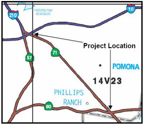
TCRP #50 - Route 71 Freeway (07-LA-71 0.5/ 4.5)
 In September 2000, the California Transportation
Commission considered a $1.5 million proposal to complete three miles of
six-lane freeway of Route 71 between I-10 and Route 60. This is District 7
TCRP Project #50. The project includes adding one mixed flow lane and one
HOV lane in each direction on Route 71 between I-10 and Route 60,
converting existing 6-lane expressway to 8-lane freeway between Holt
Avenue and Mission Boulevard, and converting existing 4-lane expressway to
6-lane freeway between Mission Boulevard and Route 60. This segment is the
last remaining segment to be converted to freeway and to provide HOV lanes
between I- 10 and Route 91. Project Location The total estimated cost was
$146 million. The estimated construction completion date is June 2009.
However, the project was up for suspension (due to budget) in December
2003. Funds were shifted to Project 41.1 (Route 5 HOV Lanes). Construction
is now scheduled for completion in February 2011. Additionally, funds were
deallocated from the early phases of this project in September 2005 due to
the inactivity of the project.
In September 2000, the California Transportation
Commission considered a $1.5 million proposal to complete three miles of
six-lane freeway of Route 71 between I-10 and Route 60. This is District 7
TCRP Project #50. The project includes adding one mixed flow lane and one
HOV lane in each direction on Route 71 between I-10 and Route 60,
converting existing 6-lane expressway to 8-lane freeway between Holt
Avenue and Mission Boulevard, and converting existing 4-lane expressway to
6-lane freeway between Mission Boulevard and Route 60. This segment is the
last remaining segment to be converted to freeway and to provide HOV lanes
between I- 10 and Route 91. Project Location The total estimated cost was
$146 million. The estimated construction completion date is June 2009.
However, the project was up for suspension (due to budget) in December
2003. Funds were shifted to Project 41.1 (Route 5 HOV Lanes). Construction
is now scheduled for completion in February 2011. Additionally, funds were
deallocated from the early phases of this project in September 2005 due to
the inactivity of the project.
In June 2007, the CTC considered an amendment to TCRP #50. This amendment proposes to add the Route 71/Mission Grade Separation project (STIP PPNO 2232) to the scope of this TCRP project and program new TCRP funds for construction. The Mission Grade Separation project is located within the Route 71 project corridor. The environmental document covers both projects. Although, the Route 71 freeway conversion project (original scope of TCRP Project #50) is on hold due to insufficient funding the Los Angeles County Metropolitan Transportation Authority is committed to fully fund the project when funding becomes available. This amendment will help to achieve an increment of the intended goal of TCRP Project #50 by improving flow as an early stage implementation. Construction was revised to complete in the FY 2012/2013 time period. As of November 2008, the grade separation project between Mission Blvd and Route 71 was underway. The median on Route 71 had been completely paved, the left turn lanes have been reduced from two lanes to one, and equipment is ready to drive beams into the northbound Route 71 lanes to start that portion of the grade change and overpass.
In September 2002, the CTC considered future consideration of funding for upgrading the freeway and improving the interchange in Pomona. In particular, the City of Pomona has a project to improve the interchange of Mission Blvd and Route 71. This project will remove the existing at-grade intersection of Mission Boulevard at Route 71 by constructing an overcrossing of Mission Boulevard over the existing Route 71 expressway. Six through lanes and two turning lanes are proposed for the overcrossing, and the design provides a compressed diamond configuration allowing full uncontrolled ingress and egress on Route 71 using standard freeway type on and off-ramps. Completion of the project will improve traffic circulation at this heavily used intersection. The project schedule anticipates advertising for construction bids in early 2007 with estimated construction starting in Summer 2007. Construction is anticipated to take 24 months to complete. It appears that, as part of this project the 2nd Street intersection and the Pomona Boulevard interchange are going to be eliminated.
The SAFETEA-LU act, enacted in August 2005 as the reauthorization of TEA-21, provided the following expenditures on or near this route:
In August 2011, it was reported that the Route 71/Mission Grade Separation project (STIP PPNO 2232) was completed. Traffic on Mission is now carried up and over Route 71, eliminating the extra stops and wait time for motorists. This completes the first phase of a major project on Route 71. The second phase will convert it into a full freeway, without the city street aspect. The interchange fully opened (with all ramps functional) in December 2011. Caltrans officials have said Route 71 could become a six-lane freeway with a carpool lane by 2023.
In February 2012, it was reported that Pomona officials have been working to secure grants that would go to completing studies and other work that could help expedite turning Route 71 into a full-fledged freeway some day. Pomona has applied for a federal grant that could help pay for the design and widening of two bridges between I-10 and Mission that carry Route 71 traffic over railroad tracks. The city is seeking $25 million to go toward an estimated $33 million construction project that would involve widening to freeway width the so-called Spadra bridge and the West Pomona bridge.
In January 2013, it was reported that the Pomona City
Council was selecting their preferred alternative for the Route 71
widening between I-10 and Route 60. This is part of the project where
Pomona, Caltrans and the Los Angeles County Metropolitan Transportation
Authority have been working to update plans and studies completed in the
past to expand Route 71 from a four-lane highway to a full-fledged
eight-lane freeway between I-10 and Route 60. Currently scheduled for
completion in 2030, if earlier funding can be obtained, construction to
widen Route 71 could begin in 2015 and conclude as early as 2017. Five
options are available but the first two are not being recommended by city
public works personnel, according to a city staff report. Alternative
1 involves leaving the highway as it for the long term. Alternative
2 would require building a wider, below-ground Route 71. The
concept, approved in 2002, has a high cost in part because it would
require the acquisition of about 140 properties. Alternatives 3, 4,
and 4A, would require the acquisition of less than 40 properties in
part, in whole or temporarily. Alternative 3 involves widening
Route 71, adding a frontage road that connects Phillips Drive and North
Ranch Road and adding a pedestrian bridge near Ninth Street to replace one
at Grier Street. Alternative 4 includes completing the widening;
eliminating the current intersections at Phillips, North Ranch and Old
Pomona Road; building a frontage road between Phillips and Old Pomona;
constructing an overcrossing at Old Pomona that connects Village Loop Road
and Lexington Avenue; and adding the pedestrian bridge. Alternative
4A would include all of the elements of Alternative 4 but would
leave out the overpass. City public works personnel prefer Alternative 4
because it would enhance access to the area, the city staff report said.
(Source: Inland Valley Daily Bulletin, 1/6/13)
In March 2016, the Los Angeles MTA presented its full
proposal for what transit lines could be built -- and when -- if Los
Angeles County voters approve a half-cent sales tax increase in November
2016. This proposal included funding for a project on Route 71 from I-10
to Rio Rancho Rd. that will add 1 Mixed-Flow lane in each direction on
Route 71, from I-10 to Rio Rancho Rd. for a total of 3 miles. The project
will provide 3 Mixed Flow lanes throughout with 4 Mixed Flow lanes in
segments"
(Source: Los Angeles Times 3/18/2016; Metro Board Report 3/24/2016)
In November 2016, it was reported that Measure M will
fund an upgrade of Route 71, the highway/freeway combination that runs
between San Dimas and Corona, to a full-fledged freeway through the city
of Pomona. For most of its run through Pomona, Route 71 currently is a
four-lane highway with street intersections. Measure M is going to change
that — but it will take some time. (Route 71 is also an expressway
rather than a freeway in Riverside County between Corona and the San
Bernardino County line; Measure M will have no effect on that portion.) In
Pomona, the 71 will be widened from a four-lane highway to an eight-line
freeway, from just south of Mission Boulevard to Rio Rancho Road.
According to Caltrans, design work for the construction will be completed
in about 2020. Construction could begin by late that year, and will take
about four years.
(Source: Daily Bulletin, 11/22/2016)
In March 2017, the CTC authorized that $395,000 be allocated from Budget Act Item 2660-002-3007 for plans, specifications and estimates for the State administered TCRP project "Route 71 Expressway to Freeway Conversion" (Route 10 to Route 60). On Route 71 in Pomona, between Route 10 and Route 60 (07-LA-71 0.5/ 4.5). Add one mixed flow lane and one HOV lane in each direction on Route 71. Future consideration of funding approved under Resolution E-02-48; October 2002.
In June 2017, the CTC authorized transfer of TCRP savings from projects on I-10 and I-405 to other projects, including TCRP #50. TCRP Project 50 includes $30,000,000 in TCRP funding for two segments along Route 71: Mission Boulevard/Route 71 Interchange (PPNO 2232) and Route 71 – six lanes from Route 10 to Route 60 (PPNO 2741). A total of $16,400,000 was previously programmed and allocated for construction of the Mission Boulevard/Route 71 Interchange segment (PPNO 2232) and the project is now complete. A total of $4,800,000 was previously programmed and allocated for the Route 71 – six lanes from Route 10 to Route 60 segment (PPNO 2741), leaving an un-programmed balance of $8,800,000. The Department and Metro propose to re-program the $8,800,000 of identified TCRP savings to the Design (PS&E) phase of the Route 71 - six lanes from Route 10 to Route 60 segment and update the project schedule and funding plan. This programming action, along with the addition of federal re-purposed funds, will fully fund the PS&E phase.
In conjunction with the above, the CTC also approved the following Tier 2 allocation: Los Angeles 07-LA-71 0.5/ 4.8 $8,800,000 Project 50 - Route 71 Expwy to Fwy Conversion (Route 10 to Route 60) . In Pomona, between Route 10 and Route 60. Add one mixed flow lane and one HOV lane in each direction on Route 71. Future Consideration of Funding approved under Resolution E-02-48; October 2002. Outcome/Output: The project proposes to upgrade 3.2 miles of existing four-lane expressway to an eight-lane freeway by adding 6.4 lane miles of mixed flow and 6.4 lane miles of concurrent flow HOV lanes. Allocation to come from TCRP savings as follows: • Tier 2: $8,800,000 from TCRP Project 52 - HOV and Auxiliary Lanes, Waterford to Route 10.
The 2018 STIP, approved at the CTC March 2018 meeting, appears to close out PPNO 2741, Convert to 6-lane freeway, Route 10 to Route 60, but to add a new PPNO 2741N, Convert to 8-lane fwy, Rt 10-Mission Rd, HOV+mixed-flow , for $20,000K in construction and construction support in FY20-21.
In April 2018, it was reported that Metro was applying
for TCRP (Trade Corridor Relief Program) funds in addition to SB1 funds
for the Route 71 Freeway Conversion Project in the San Gabriel Valley that
will upgrade Route 71 to a full freeway between I-10 and Rio Rancho Road..
(Source: Metro The Source, 4/19/2018)
In March 2019, it was reported that Caltrans workers
have begun the work to demolish some of the 17 homes needed to make way
for the long-awaited Route 71 Freeway expansion in Pomona. For years, the
state agency had plans to grow Route 71 from four to eight lanes and add a
pedestrian bridge over the highway at Grier Street. It wasn’t
possible until funding was identified in 2016, when voters approved
Measure M, known as the Los Angeles County Traffic Improvement Plan, a
half-percent sales tax for multiple transportation projects that range
from bike paths in the San Fernando Valley to extending the Gold Line to
Claremont. According to Caltrans, to make way for the project, the agency
needed to purchase 17 homes between Mission and Phillips boulevards in the
Pomona neighborhoods of Westmont and Phillips Ranch. In a statement
Friday, Caltrans said 12 of the single family residences have been
purchased or are near closing escrow. The remaining five homes are pending
settlements with negotiations well underway. Demolition work has begun on
the dozen properties Caltrans now owns, and the occupants have relocated.
Three properties have been demolished and the remaining vacated properties
are scheduled to be competed in the early weeks of April, Caltrans said.
According to a March 4 2019 staff report to the City Council, the first
phase of this project will encompass the southern portion of Route 71,
from Route 60 to Mission Boulevard. The second phase is currently planned
to run from Mission Boulevard to I-10.
(Source: San Gabriel Valley Tribune, 3/17/2019)
In November 2019, it was reported that the Route 71
Project Phase 1 has completed design and Caltrans is in the process of
acquiring the Rights-of-Way (ROW). Phase 1 will be ready to be advertised
for construction in April 2020. Funding for construction must be
programmed before Caltrans can advertise the Phase 1 project.
(Source: AARoads "71 Freeway Upgrade (Pomona) Likely to start in mid-2020", 12/9/2019)
In March 2020, the CTC approved the 2020 STIP, which
continues the programmed funding for PPNO 2741N "Convert to 8-lane fwy, Rt
10-Mission Rd, HOV+mixed-flow (TCEP)" of $20,000K in FY21-22.
(Source: March 2020 CTC Agenda, Item 4.7, 2020 STIP
Adopted 3/25/2020)
In June 2020, the CTC approved an amendment to the
Trade Corridor Enhancement Program (TCEP) regarding this project:
specifically, to reduce the scope, benefits, funding, and amend the
Baseline Agreement (BA) for the Route 71 Expressway to Freeway Conversion
project (PPNO 2741S). The amendment proposes the following scope changes:
(Source: June 2020 CTC Agenda, Agenda Item
2.1s.(4))
The June 2020 agenda item noted that the Route 71
Expressway to Freeway Conversion project (PPNO 2741S) was originally
programmed under the parent project (PPNO 2741) between PM R0.5 to R4.8
from I-10 to the Los Angeles (LA)/San Bernardino (SBD) County Line (CL).
Subsequently, the parent project was segmented, as shown below, in order
to accelerate the construction of the South Segment. This gave two
segments: (1) North Segment (PPNO 2741N) - PM R0.5 to R1.6 from I-10 to
Mission Boulevard (Blvd); and (2) South Segment (PPNO 2741S) - PM R1.6 to
R4.8 from Mission Blvd to the LA/SBD CL. The Route 71 Expressway to
Freeway Conversion project (PPNO 2741S) was adopted by the Commission at
its May 2018 meeting under Resolution TCEP-P-1718-01. A BA was approved by
the Commission at the October 2018 meeting under Resolution
TCEP-P-1819-05B. The project was programmed with TCEP funds for
$44,000,000 for the project construction phase, for a total project cost
of $175,519,000. As Plans, Specifications & Estimates (PS&E)
activities progressed for this project, the Project Development Team (PDT)
realized that the existing Southern California Edison (SCE) electrical
poles that ran parallel to the roadway were in conflict with the widening.
These poles could not be relocated outside of the State Right of Way (R/W)
due to limited space within the adjacent residential properties. It was
decided that the SCE poles should be relocated within the State R/W with a
Joint Use Agreement. The relocation of poles resulted in the existing open
drainage ditch to be changed to a large size closed Reinforced Concrete
Box (RCB). This change also required the roadway profile to be elevated up
to 5 feet and additional retaining walls were needed for the RCB to meet
grade requirements at the southern end of the project. These unforeseen
changes to the scope have increased the PS&E cost by $2,175,000.
Furthermore, during the Design phase, the PDT also realized that the
proposed location of the new POC at the northern limit of the project
needs to be relocated or re-designed due to flooding. The flooding stems
from the culvert being connected to LA County’s undersized pipe that
cannot handle the volume during a storm and backs up water to the frontage
road. Resolving these issues will take time as it involves collaboration
with LA County. The project will terminate the roadway widening 0.2 mile
early at the northern limit of PM 1.8 at the existing POC because there is
not enough horizontal clearance for the widening. The southern limit has
been increased by 0.2 mile to complete the median pavement to provide
continuous HOV lanes up to the undercrossing. This will close the gap and
facilitate joining the proposed HOV lanes to the existing Route 71 HOV
lanes. As this project is on an accelerated schedule, removal of the new
POC and termination of the widening 0.2 mile early at the northern limit
was deemed appropriate by the PDT, due to the long lead times needed to
resolve the issues. As a result, the new POC, widening, R/W acquisition
and utility relocation work at the northern limit of the project will be
done as part of the North Segment project (2741N) reducing the R/W Capital
cost of the South Segment by $15,500,000, which will be transferred to the
North Segment (2741N).
(Source: June 2020 CTC Agenda, Agenda Item
2.1s.(4))
In June 2020, the CTC approved the following allocation
amendment for a State-Administered TCEP project: $43,025,000. 07-LA-71
1.8/R4.7. PPNO 07-2741S ProjID 0719000068 EA 21062. Route 71
Expressway to Freeway Conversion (Mission Road to Route 60). In
Pomona from Mission Road to Route 60. Add on mixed lane and one HOV lane
in each direction. CON ENG $5,000,000 CONST $39,000,000 $38,025,000.
Amendment is reducing the scope (deleting a bridge) and a corresponding
reduction in TCEP Construction Capital funding.
(Source: June 2020 CTC Agenda, Agenda Item 2.5s.(6)
#1)
In March 2021 the CTC received notice of, and in May
2021 the CTC had on its agenda, a STIP amendment (likely approved) to
amend the Route 71 Expressway to Freeway Conversion project (PPNO 2741N)
in Los Angeles County, to delay construction by two years from Fiscal Year
2021-22 to 2023-24. The Route 71 Expressway to Freeway Conversion project
(PPNO 2741N) was originally programmed under the parent project (PPNO
2741) between Post Mile (PM) R0.5 to R4.8 from I-10 to the Los Angeles
(LA)/San Bernardino (SBD) County Line (CL). Subsequently, the parent
project was segmented in order to accelerate the construction of the South
Segment: (1) North Segment (PPNO 2741N) - PM R0.5 to R1.6 from I-10 to
Mission Boulevard (Blvd); (2) South Segment (PPNO 2741S) - PM R1.6 to R4.8
from Mission Blvd to the LA/SBD CL. The project (PPNO 2741N) proposes to
add one mixed flow lane and one high occupancy vehicle lane in each
direction to increase capacity and reduce congestion, increase traffic
safety and accommodate future traffic demands resulting from regional
growth. Metro is the project sponsor and has programmed $20,000,000
STIP Regional Improvement Program funds and $109,000,000 local funds for
construction and construction support in 2021-22. The South Segment
(PPNO 2741S) project is scheduled to complete construction by Summer of
2024. Metro and the Department are requesting to delay the construction
schedule for this North Segment (PPNO 2741N) project until after
completion of the South Segment project to avoid conflicts between the
contractors for the two projects due to the overlapping work where the
projects adjoin, which may result in delays and claims. A cost
increase is not anticipated due to these schedule delays.
(Source: March 2021 CTC Agenda, Agenda Item
2.1b.(2); May 2021 CTC Agenda, Agenda Item 2.1a.(3))
In June 2021, it was reported that Caltrans and Metro
celebrated a groundbreaking for the project to widen Route 71 through
Pomona. The Route 71 project will convert about 3.5 miles of existing
four-lane expressway into an eight-lane freeway. Construction for the
first phase – $174 million for just under two miles – is
expected to complete in 2024. This construction has resulted in the
closure of the remaining "right in, right out" intersections to SB Route 71. Widening Route 71 was included in Metro’s 2016 Measure M
sales tax expenditure plan, which programs $248.5 million for a FY2022
groundbreaking and an anticipated FY2026 opening. The project also
received $43 million in state SB 1 gas tax funding. Most of the demolition
of homes near the route occurred decades ago; there are 3-4 remaining
homes. Removal of those homes remains an area of controversy due to the
approach Caltrans is taking. Caltrans’ is demolishing at least 18
homes, when their approved widening plan only called for around 12.
(Source: Streetsblog LA, 6/17/2021; Streetsblog LA, 7/13/2021)
In March 2023, it was reported that Phase 2 of the
project, North Segment (PPNO 2741N) - PM R0.5 to R1.6 from I-10 to Mission
Boulevard (Blvd), is facing a project funding shortfall of “up to
$99 million” with “significant cost increases and potential
schedule delays.” Specifically, utility and railroad coordination
are causing delays. Additionally, there may be widening issues with the
replacement POC for the existing Grier Street Pedestrian Overcrossing. The
project plans to demolish that POC and replace it with a new longer
pedestrian bridge, to be located one block north at 9th Street. The
pedestrian overcrossing allows students living east of the freeway to walk
to Westmont Elementary School. The existing ~100-foot-long freeway span is
too short to accommodate Metro and Caltrans’ planned 8-lane freeway
underneath. The new span requires additional engineering to avoid flooding
issues.
(Source: Streetsblog LA, 3/2/2023)
In September 2023, it was reported that OHLA USA Inc.
began work on Phase 1 of the Route 71 Expressway to Freeway Conversion
Project in spring 2021 and crews are hard at work to deliver it by summer
2025. The $174.544 million project, taking place in the city of Pomona,
covers 2.7 mi. between Route 71/I-10 interchange (Mission Boulevard) and
the Los Angeles/San Bernardino County Line. Phase 2 of the project, the
North Segment, covers the area from the Route 71/I-10 interchange to
Mission Boulevard. Construction is expected to begin next spring, with a
completion in spring 2027. As of September 2023, OHLA USA has completed
Stage 1 of the roadway jointed plain concrete pavement (JPCP) roadway
project, which included demolition of existing AC/JPCP, excavation and
backfill of base, placement/revisions to existing drainage systems and
placement of new JPCP. All existing roadway concrete/AC pavement, median
barriers, traffic signage and underground drainage are being demolished.
New concrete lanes are being constructed, along with a concrete/asphalt
median. However, it was also reported that the Route 71 freeway expansion
costs are ballooning: Metro and Caltrans are currently spending $180+
million to widen a mile and a half long stretch of the Route 71 Freeway in
Pomona, via right-of-way where the agencies demolished nearly two dozen
homes, and continue to pressure to evict a lone holdout. The project
expands the four-lane freeway to eight lanes. Metro and Caltrans plan a
second phase - to be located north of the current widening. According to a
new Caltrans presentation, the second "SR-71 North Segment" cost recently
shot up from an anticipated $169 million to $309 million. Meanwhile
Caltrans and Metro have allowed that northern portion of Route 71 to fall
into dangerous disrepair. In rainy weather earlier this year, that stretch
developed potholes that caused flat tires for dozens of drivers.
(Source: Construction Equipment Guide, 9/6/2023; Streetsblog LA, 9/19/2023)
In August 2010, the CTC approved relinquishment of right of way in the city of Chino Hills along Route 71 between Chino Hills Parkway and Pine Avenue (~ SBD R3.339 to SBD R6.516), consisting of collateral facilities.
The SAFETEA-LU act, enacted in August 2005 as the reauthorization of TEA-21, provided the following expenditures on or near this route:
In June 2002, the CTC had on its agenda a proposal for Route 71 near City of Chino from San Bernardino County line to Santa Ana River (~ RIV 0.000 to RIV 2.795 to widen it to four lane expressway including two additional animal crossings.
Route 71/Route 91 Interchange (~ RIV R2.895)
![[TCRP 64]](maps/091-tcrp-64.jpg) There are currently plans (TCRP #64) to improve the Green River Interchange to NB Route 71, including adding an
auxiliary lane and connector ramp. (June 2002 CTC Agenda Item 2.1c.(1)).
In August 2007, the CTC approved two actions regarding this project,
specifically with Project #64.1 and #64.2. TCRP #64.1 would improve the
Green River Interchange and add an auxiliary lane and connector ramp east
of the Green River Interchange to northbound Route 71 in Riverside County.
Project #64.2 would improve the Green River Interchange and add an
auxiliary lane and connector ramp east of the Green River Interchange to
northbound Route 71 in Riverside County. The actions that were approved
were to transfer $590,000 in TCRP funding from TCRP #64.1 to TCRP #64.2
for Plans, Specifications, and Engineering (PS&E), to program
$4,410,000 in new TCRP funds for PS&E on #64.2, and to update
schedules. The overall project goal is to relieve congestion and improve
local traffic circulation on Route 91 in the area of Green River Road and
Route 71. TCRP Project #64.1 relieves congestion on Route 91 in the area
of Green River Road and Route 71 and improves local traffic circulation on
Green River Road in the vicinity of Route 91 by replacing the current
3-lane Green River Road overcrossing with a 6-lane overcrossing,
modification of ramps, and local street improvements at the interchange.
Project 64.1 was completed in 2007 with funds remaining in the account due
to various transfers. TCRP Project #64.2 relieves congestion on Route 91
in the eastbound direction by adding a lane in the vicinity of the Green
River Interchange on eastbound Route 91 between Route 241 and Route 71,
near the Riverside/Orange County line, extending to the Route 71/Route 91
interchange near the city of Corona in Riverside County. This project
should complete in FY11/12.
There are currently plans (TCRP #64) to improve the Green River Interchange to NB Route 71, including adding an
auxiliary lane and connector ramp. (June 2002 CTC Agenda Item 2.1c.(1)).
In August 2007, the CTC approved two actions regarding this project,
specifically with Project #64.1 and #64.2. TCRP #64.1 would improve the
Green River Interchange and add an auxiliary lane and connector ramp east
of the Green River Interchange to northbound Route 71 in Riverside County.
Project #64.2 would improve the Green River Interchange and add an
auxiliary lane and connector ramp east of the Green River Interchange to
northbound Route 71 in Riverside County. The actions that were approved
were to transfer $590,000 in TCRP funding from TCRP #64.1 to TCRP #64.2
for Plans, Specifications, and Engineering (PS&E), to program
$4,410,000 in new TCRP funds for PS&E on #64.2, and to update
schedules. The overall project goal is to relieve congestion and improve
local traffic circulation on Route 91 in the area of Green River Road and
Route 71. TCRP Project #64.1 relieves congestion on Route 91 in the area
of Green River Road and Route 71 and improves local traffic circulation on
Green River Road in the vicinity of Route 91 by replacing the current
3-lane Green River Road overcrossing with a 6-lane overcrossing,
modification of ramps, and local street improvements at the interchange.
Project 64.1 was completed in 2007 with funds remaining in the account due
to various transfers. TCRP Project #64.2 relieves congestion on Route 91
in the eastbound direction by adding a lane in the vicinity of the Green
River Interchange on eastbound Route 91 between Route 241 and Route 71,
near the Riverside/Orange County line, extending to the Route 71/Route 91
interchange near the city of Corona in Riverside County. This project
should complete in FY11/12.
In October 2011, the CTC approved for future consideration of funding a project to construct a direct flyover connector from eastbound Route 91 to northbound Route 71 and reconfigure the eastbound Route 91 ramp between Green River Road and the Route 91/Route 71 interchange. The project is not fully funded. The project is programmed in the 2010 State Transportation Improvement Program. The total estimated cost is $113,000,000 for capital and support. Construction is estimated tobegin in Fiscal Year 2015-16. The scope as described for the preferred alternative is consistent with the project scope programmed by the Commission in the 2010 State Transportation Improvement Program. A copy of the MND has been provided to Commission staff. Due to potential impacts to hazardous waste, visual resources, hydrology and water quality, noise, biological resources, and traffic, an Initial Study was completed for the project. Based upon environmental studies and proposed environmental commitments, including minimization and avoidance measures, restoration activities, and incorporation of BMPs, the project will not have a significant effect on the environment. As a result, an MND was completed for this project.
In April 2018, it was reported that the RCTC requested
state funds to cover most of the $117 million cost of the long awaited
Route 71/Route 91 interchange rework, and the California Transportation
Commission could approve the request in May. Riverside County officials
proposed putting up $23.4 million, or 20 percent of the price tag.
However, there’s one giant qualification: Even if the Riverside
County Transportation Commission manages to win a promise to fund the
project, the dollars would come from a pot of money generated by
California’s controversial raising of the gasoline tax increase last
year through SB1 and there is a movement under way to repeal the tax
increase. Parsons Transportation Group did an environmental analysis in
June 2011, then updated it in November 2014, a commission report states.
Because of the time that has elapsed, officials say the analysis needs to
be updated again. That effort received a $2 million boost earlier this
year from the state transportation agency. As for the project, the
centerpiece is a new sweeping, multi-lane flyover ramp that would connect
eastbound Route 91 with northbound Route 71. It would also reconfigure the
eastbound Route 91 ramp between Green River Road and the Route 71/Route 91, the report states. If the state commission funds the interchange, and
if the gas tax survives, construction could start in 2019 and take about
two years.
(Source: Press Enterprise, 4/14/2018)
In November 2020, it was reported that the California
Transportation Commission staff recommended on 11/16/2020 to fund this
project and two others in Riverside County. The CTC will vote December 2
and 3, 2020 on the recommendations, which were made through a statewide
competitive grant process. A “yes” vote by the CTC would
allocate gas tax revenue from Senate Bill 1 to projects that include $58.1
million for the Route 71/Route 91 Interchange Project, Corona.
(Source: RCTC, 11/18/2020)
In March 2021, the CTC received notice of a proposed
amendment to the 2020 STIP to program an Assembly Bill (AB) 3090
reimbursement project (PPNO 0077M) in order to advance the construction of
the Route 91/Route 71 Interchange and Connectors project (PPNO 0077G) in
Riverside County with local funds (Measure A). It is proposed to schedule
the AB 3090 reimbursement over a three-year period beginning in Fiscal
Year 2022-23. The Route 91/71 Interchange and Connectors project (PPNO
0077G) will replace the eastbound Route 91 to northbound Route 71 loop
connector with a direct connector ramp. It will also realign the Green
River Road eastbound entrance ramp to Route 91 and construct a
collector/distributor system in the eastbound direction between the Green
River Road and Serfas Club Drive. Currently, $66,377,000 in Regional
Improvement Program funding is programmed in 2022-23 to the construction
(CON) phase of the project. On December 2, 2020, the Commission
approved programming of $58,108,000 of Senate Bill 1 Trade Corridor
Enhancement Program funds in 2021-22 for CON phase, per Resolution
G-20-77, to the Route 91/Route 71 Interchange and Connectors project. RCTC
anticipates this project being ready to list in December 2021 with
contract award shortly thereafter. However, the STIP funds for this
project are programmed in 2022-23 and cannot be allocated in advance due
to capacity constraints in the 2020 STIP. As such, RCTC proposes to fund
the construction component with local funds (Measure A) in order to
accelerate delivery in 2021-22. The amendment was approved by the
CTC in June 2021.
(Source: March 2021 CTC Agenda, Agenda Item
2.1b.(3); June 2021 CTC Agenda, Agenda Item 2.1a.(20))
In July 2021, it was reported that improving the
heavily congested and operationally deficient Route 71/Route 91
Interchange in Corona took another step forward with the Riverside County
Transportation Commission’s award of a construction management
contract to Corona-based Falcon Engineering. The interchange serves as a
gateway between Riverside, Orange, and San Bernardino counties and is a
vital link for commuters and freight vehicles that use the Route 91. The
interchange reconstruction project is designed to help relieve traffic
congestion, increase travel reliability, improve safety, and enhance air
quality. Project team members are finalizing environmental approvals,
plans, and permits before advertising for construction bids in Spring
2022. Construction is expected to start during the second half of 2022 and
take about three years to complete.
(Source: RCTC, 7/7/2021)
In August 2021, the CTC revised the June 2021 amendment
to the STIP: Revise: Route 71/Route 91 interchange EB-NB Connector project
(PPNO 0077G, EA 0F541). 08-RIV-091 R0.900/R2.600. Route 91 Near the City
of Corona in Riverside County. Replace eastbound Route 91 to northbound
Route 71 loop connector with a direct connector ramp. Realign the Green
River Road eastbound entrance ramp to Route 91and construct a
collector/distributor system on Route 91 in the eastbound direction
between the Green River Road and Serfas Club Drive. Updated financials ($
× 1,000): Const Cap: $135,615 ⇒ $145,684; Total $164,844
⇒ $174,913.
(Source: August 2021 CTC Agenda, Agenda Item
2.1a.(2))
In March 2022, the CTC approved a request of
$68,177,000 for the locally-administered multi-funded TCEP/STIP Route 71/Route 91 Interchange EB-NB Connector project (08-Riv-091 R0.9/R2.6;
08-Riv-071 1.9/3.0), on the State Highway System, in Riverside County,
programmed in FY 2022-23. (PPNO 08-0077G; ProjID 0800000137; EA 0F541).
Replace eastbound Route 91 to northbound Route 71 loop connector with a
direct connector ramp. Realign the Green River Road eastbound entrance
ramp to Route 91, and construct a collector/distributor system on Route 91
in the eastbound direction between the Green River Road and Serfas Club
Drive.
(Source: March 2022 CTC Agenda, Agenda Item
2.5s.(5) / 2.5v.(4))
 In January 2023, the CTC approved for future
consideration of funding the following project for which a MND and
Addendum have been completed: 08-Riv-71, PM 1.6/3.0, 08-Riv-91, PM
R0.6/R2.6. State Route 91/State Route 71 Interchange Improvement
Project. Route 71 and Route 91 in Riverside County. Replace
eastbound Route 91 to northbound Route 71 loop connector with a direct
connector ramp. Realign the Green River Road eastbound entrance ramp to
Route 91 and construct a collector/distributor system on Route 91, in the
eastbound direction between Green River Road and Serfas Club Drive, in
Riverside County. (PPNO 0077G) This project is located in Riverside
County. The project will construct a direct flyover connector from
eastbound Route 91 to northbound Route 71 and reconfigure the eastbound
Route 91 ramp between Green River Road and the Route 91/Route 71
interchange. The project is programmed in the 2020 STIP. The total cost is
$174,913,000, which includes SB 1 TCEP funding in Construction (capital).
Construction is estimated to begin in 2022-23. The scope as described for
the preferred alternative is consistent with the project scope programmed
by the Commission in the 2020 STIP. A MND was prepared because of
potential biological resource impacts. A copy of the MND has been provided
to Commission staff. The Commission approved the project for future
consideration of funding on October 27, 2011, under Resolution E-11-74.
Changes to the scope include Right-of-Way and easement modifications,
additional rock slope protection, culvert modifications, the addition of
two sound walls, and grading modifications. The Department subsequently
completed an Addendum to the MND pursuant to the California Environmental
Quality Act. The Department has approved this project for construction.
This approval and the Addendum will satisfy the environmental requirements
for this stage of the planning process.
In January 2023, the CTC approved for future
consideration of funding the following project for which a MND and
Addendum have been completed: 08-Riv-71, PM 1.6/3.0, 08-Riv-91, PM
R0.6/R2.6. State Route 91/State Route 71 Interchange Improvement
Project. Route 71 and Route 91 in Riverside County. Replace
eastbound Route 91 to northbound Route 71 loop connector with a direct
connector ramp. Realign the Green River Road eastbound entrance ramp to
Route 91 and construct a collector/distributor system on Route 91, in the
eastbound direction between Green River Road and Serfas Club Drive, in
Riverside County. (PPNO 0077G) This project is located in Riverside
County. The project will construct a direct flyover connector from
eastbound Route 91 to northbound Route 71 and reconfigure the eastbound
Route 91 ramp between Green River Road and the Route 91/Route 71
interchange. The project is programmed in the 2020 STIP. The total cost is
$174,913,000, which includes SB 1 TCEP funding in Construction (capital).
Construction is estimated to begin in 2022-23. The scope as described for
the preferred alternative is consistent with the project scope programmed
by the Commission in the 2020 STIP. A MND was prepared because of
potential biological resource impacts. A copy of the MND has been provided
to Commission staff. The Commission approved the project for future
consideration of funding on October 27, 2011, under Resolution E-11-74.
Changes to the scope include Right-of-Way and easement modifications,
additional rock slope protection, culvert modifications, the addition of
two sound walls, and grading modifications. The Department subsequently
completed an Addendum to the MND pursuant to the California Environmental
Quality Act. The Department has approved this project for construction.
This approval and the Addendum will satisfy the environmental requirements
for this stage of the planning process.
(Source: January 2023 CTC Agenda, Agenda Item 2.2c.(5))
Also in January 2023, the CTC approved an amendment for
the locally administered multi-funded SB 1 TCEP/STIP Route 71/Route 91
Interchange EB-NB Connector project (PPNO 0077G), on the State Highway
System, in Riverside County, to allow non-proportional spending for the
construction phase. The Commission allocated an advancement of $68,177,000
in March 2022, to the Riverside County Transportation Commission (RCTC)
for the locally-administered multi-fund SB 1 TCEP/STIP Route 71/Route 91
Interchange EB-NB Connector project for Construction phase. At that time,
the allocation approval the implementing agency, RCTC, did not request
non-proportional spending. Because of this, RCTC is now requesting
non‐proportional spending to fully exhaust the Federal earmarks
during the early stages of project delivery to maximize the use of Federal
funds. Otherwise, critical funding would be lost, and a local contribution
would be required. As such, RCTC requires non‐proportional spending
to meet the funding targets above.
(Source: January 2023 CTC Agenda, Agenda Item 2.5s.(8))
In May 2023, the CTC approved the following allocation
for a locally-administered STIP project: $19,913,000. 08-Riv-91 R0.9/R2.6;
08-Riv-71 1.9/3.0. PPNO 08-0077M; ProjID 0823000023 0800000137;
EA 1N121 0F541. AB 3090 Reimbursement - Route 71/Route 91 Interchange EB-NB Connector. Replace eastbound Route 91 to
northbound Route 71 loop connector with a direct connector ramp. Realign
the Green River Road eastbound entrance ramp to Route 91, and construct a
collector/distributor system on Route 91 in the eastbound direction
between the Green River Road and Serfas Club Drive. CEQA - CE, 10/12/2021
NEPA - CE, 10/12/2021. Right of Way Certification: 02/04/2022. Future
consideration of funding approved under Resolution E-11-74; October 2021.
Allocation: CONST $19,913,000.
(Source: May 2023 CTC Agenda, Agenda Item 2.5c.(8))
In October 2023, the CTC approved the following
locally-administered STIP AB 3090 Reimbursement project allocation:
$33,189,000. 08-Riv-91 R0.9/R2.6; 08-Riv-71 1.9/3.0. PPNO 08-0077M; ProjID
0800000137; EA 0F541. AB 3090 Reimbursement. Replace eastbound
Route 91 to northbound Route 71 loop connector with a direct connector
ramp. Realign the Green River Road eastbound entrance ramp to Route 91,
and construct a collector/distributor system on Route 91 in the eastbound
direction between the Green River Road and Serfas Club Drive. CEQA - MND,
06/29/2011; Re-validation 10/12/2021. NEPA - CE, 06/29/2011; Re-validation
10/12/2021. Right of Way Certification: 02/04/2022. Future consideration
of funding approved under Resolution E-11-74: October 2021. Contribution
from other sources: $0. Reimbursement as AB 3090 approved under STIP
Amendment 20S-08, June 2021. Allocation: CONST $33,189,000.
(Source: October 2023 CTC Agenda, Agenda Item 2.5c.(4))
Dawson/Dos Lagos Widening (Temescal Canyon)
 In March 2018, it was reported that a $12.3 million funding agreement for a widening project
intended to relieve heavy congestion on Temescal Canyon Road between Lake
Elsinore and Corona has won approval from Riverside County supervisors.
The Riverside County Transportation Commission is supporting the project
with Measure A infrastructure funds, and under the agreement unanimously
approved Tuesday, March 13, by the Board of Supervisors, the commission
will release the money as the project progresses. About $2.7 million is
expected to be used in the current fiscal year, which ends June 30.
Construction is likely to begin in fall and end in the first half of 2020.
Temescal Canyon Road is the primary north- south road in the area and
often is an alternate route for motorists trying to avoid congestion on
I-15 during peak commuting hours, a transportation agency statement said.
In March 2018, it was reported that a $12.3 million funding agreement for a widening project
intended to relieve heavy congestion on Temescal Canyon Road between Lake
Elsinore and Corona has won approval from Riverside County supervisors.
The Riverside County Transportation Commission is supporting the project
with Measure A infrastructure funds, and under the agreement unanimously
approved Tuesday, March 13, by the Board of Supervisors, the commission
will release the money as the project progresses. About $2.7 million is
expected to be used in the current fiscal year, which ends June 30.
Construction is likely to begin in fall and end in the first half of 2020.
Temescal Canyon Road is the primary north- south road in the area and
often is an alternate route for motorists trying to avoid congestion on
I-15 during peak commuting hours, a transportation agency statement said.
(Source: Press Enterprise, 3/14/2018)
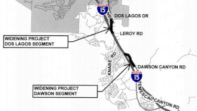
In June 2018, the CTC approved for future consideration of funding a project that will construct roadway improvements to widen Temescal Canyon Road (former Route 71) from two to four lanes along two segments of roadway between Dawson Canyon Road and Dos Lagos Drive (total length 1.3 miles). The Project is estimated to cost $23,470,000 and is fully funded through construction with Local Funds ($3,870,000), Riverside County Transportation Commission Measure A Funds ($12,300,000), and Local Partnership Program Funds ($7,300,000). Construction is estimated to begin in Fiscal Year 2018-19
 Commuter Lanes
HOV lanes are planned or under construction as follows:
 Naming
 The segment from I-10 to Route 60 (~ LA R0.682 to LA R4.217) has been named
the "Pomona Police Officer Daniel T. Fraembs Memorial Highway". It
was dedicated on Friday, May 11, 2001, however, the legislation formally
naming the route was not approved until July 26, 2001. Pomona Police
Departement Officer Daniel T. Fraembs was born an orphan in Hong Kong. The
story is that as an infant, he was found abandoned on a beach by a Hong
Kong policeman who brought him to an orphanage. He was adopted at the age
of nine months by Donald and Dorothy Fraembs of Cincinnati, Ohio. He
became a citizen in 1963, graduated from high school and Fullerton
Community College, joined the United States Marine Corps, and then the
Orange County Sheriff's Department, where he worked for five years. In
1993, he joined the Pomona Police Department as a police officer. On May
11, 1996, he was ambushed during a confrontation with two gang members
near Humane Way, near the Humane Society driveway. He was the first police
officer in the department's 108-year history to be killed in the line of
duty. Ronald Bruce Mendoza was convicted of Fraembs' murder and is
awaiting execution in San Quentin Prison. Named by Senate Concurrent
Resolution 12, Chapter 92, July 26, 2001.
The segment from I-10 to Route 60 (~ LA R0.682 to LA R4.217) has been named
the "Pomona Police Officer Daniel T. Fraembs Memorial Highway". It
was dedicated on Friday, May 11, 2001, however, the legislation formally
naming the route was not approved until July 26, 2001. Pomona Police
Departement Officer Daniel T. Fraembs was born an orphan in Hong Kong. The
story is that as an infant, he was found abandoned on a beach by a Hong
Kong policeman who brought him to an orphanage. He was adopted at the age
of nine months by Donald and Dorothy Fraembs of Cincinnati, Ohio. He
became a citizen in 1963, graduated from high school and Fullerton
Community College, joined the United States Marine Corps, and then the
Orange County Sheriff's Department, where he worked for five years. In
1993, he joined the Pomona Police Department as a police officer. On May
11, 1996, he was ambushed during a confrontation with two gang members
near Humane Way, near the Humane Society driveway. He was the first police
officer in the department's 108-year history to be killed in the line of
duty. Ronald Bruce Mendoza was convicted of Fraembs' murder and is
awaiting execution in San Quentin Prison. Named by Senate Concurrent
Resolution 12, Chapter 92, July 26, 2001.
(Image source: City of Pomona, Eastvale News Blog)
 The segment from Route 10 to the Riverside
County line (~ LA R0.682 to SBD R8.438) is also officially designated the
"Chino Valley Freeway". It was named by Assembly
Concurrent Resolution 20, Chapter 55, in 1993.
The segment from Route 10 to the Riverside
County line (~ LA R0.682 to SBD R8.438) is also officially designated the
"Chino Valley Freeway". It was named by Assembly
Concurrent Resolution 20, Chapter 55, in 1993.
(Image Source: Southern California Regional Rocks and Roads; Chris Sampang on AARoads)
 The segment of this route from Route 10 to Route 91 (~ LA R0.682
to RIV 2.763) is officially named the "Corona Freeway". It was
named by the State Highway Commission in 1958, and follows former LRN 77.
The first freeway segment opened in 1971. It was named because the route
traverses the community of Corona (Latin: Circle), which was named in 1896
because of the circular drive around the city; this was the scene of
spectacular auto races 1913-1916.
The segment of this route from Route 10 to Route 91 (~ LA R0.682
to RIV 2.763) is officially named the "Corona Freeway". It was
named by the State Highway Commission in 1958, and follows former LRN 77.
The first freeway segment opened in 1971. It was named because the route
traverses the community of Corona (Latin: Circle), which was named in 1896
because of the circular drive around the city; this was the scene of
spectacular auto races 1913-1916.
(Image source: The David Allen Blog)
 The segment between Route 60 and Central Avenue in San Bernardino
County (~ LA R4.217 to SBD R4.915) is named the "Correctional Officer
Manuel A. Gonzalez, Jr. Memorial Highway". This segment was named in
memory of Correctional Officer Manuel A. Gonzalez, Jr., who was stabbed to
death by an inmate on January 10, 2005 while working at the California
Institution for Men in Chino. Officer Gonzalez was born on September 15,
1961, in Los Angeles, California, and grew up in Santa Fe Springs,
California. He graduated from Pioneer High School in 1979 and thereafter
attended Rio Hondo College from 1980 to 1982. He enlisted in the United
States Army, servubg in Germany and then in Fort Carson, Colorado, and was
honorably discharged in 1986. Officer Gonzalez was hired by the Department
of Corrections and Rehabilitation in 1988, where he proudly served the
department for 17 years, working at the state prison in Corcoran,
California, until 1993, at the state prison in Lancaster, California,
until 1996, and at the California Institution for Men in Chino,
California, until his death in 2005. Officer Gonzalez was a well-respected
and reliable employee who went beyond his duties in order to assist other
staff members and worked diligently to make prison facilities more safe.
Named by Senate Concurrent Resolution (SCR) 11, Resolution Chapter 85, on
7/10/2007.
The segment between Route 60 and Central Avenue in San Bernardino
County (~ LA R4.217 to SBD R4.915) is named the "Correctional Officer
Manuel A. Gonzalez, Jr. Memorial Highway". This segment was named in
memory of Correctional Officer Manuel A. Gonzalez, Jr., who was stabbed to
death by an inmate on January 10, 2005 while working at the California
Institution for Men in Chino. Officer Gonzalez was born on September 15,
1961, in Los Angeles, California, and grew up in Santa Fe Springs,
California. He graduated from Pioneer High School in 1979 and thereafter
attended Rio Hondo College from 1980 to 1982. He enlisted in the United
States Army, servubg in Germany and then in Fort Carson, Colorado, and was
honorably discharged in 1986. Officer Gonzalez was hired by the Department
of Corrections and Rehabilitation in 1988, where he proudly served the
department for 17 years, working at the state prison in Corcoran,
California, until 1993, at the state prison in Lancaster, California,
until 1996, and at the California Institution for Men in Chino,
California, until his death in 2005. Officer Gonzalez was a well-respected
and reliable employee who went beyond his duties in order to assist other
staff members and worked diligently to make prison facilities more safe.
Named by Senate Concurrent Resolution (SCR) 11, Resolution Chapter 85, on
7/10/2007.
(Image source: Officer Down Memorial Page)
 The segment between Soquel Canyon/Central Avenue and Pine Avenue in Chino Hills (~ SBD R4.862 to SBD R6.521) is
named the "Mayor James Thalman and Mayor Michael Wickman Memorial
Highway". This segment was named in memory of Mayors James Thalman
and Michael Wickman. Mayor James Thalman was instrumental in the efforts
of the community of Chino Hills to incorporate as a city, and both he and
Michael Wickman were elected as members of the first city council of Chino
Hills in November 1991, following its incorporation as a city. During his
tenure on the city council, James Thalman was the voice of the city on
water issues and represented the city on numerous water committees, as
well as serving as a member of the League of California Cities, the Four
Corners Policy Committee, and the California Joint Powers Insurance
Authority. During his tenure on the city council, Michael Wickman
represented the city on the McCoy Equestrian Center Committee and as a
member of the board of directors for Omnitrans. James Thalman served three
terms as mayor of Chino Hills, and Michael Wickman served as mayor of
Chino Hills in 1995 and in 2000. Named by Senate Concurrent Resolution
(SCR) 52, Resolution Chapter 26, on 4/21/2006.
The segment between Soquel Canyon/Central Avenue and Pine Avenue in Chino Hills (~ SBD R4.862 to SBD R6.521) is
named the "Mayor James Thalman and Mayor Michael Wickman Memorial
Highway". This segment was named in memory of Mayors James Thalman
and Michael Wickman. Mayor James Thalman was instrumental in the efforts
of the community of Chino Hills to incorporate as a city, and both he and
Michael Wickman were elected as members of the first city council of Chino
Hills in November 1991, following its incorporation as a city. During his
tenure on the city council, James Thalman was the voice of the city on
water issues and represented the city on numerous water committees, as
well as serving as a member of the League of California Cities, the Four
Corners Policy Committee, and the California Joint Powers Insurance
Authority. During his tenure on the city council, Michael Wickman
represented the city on the McCoy Equestrian Center Committee and as a
member of the board of directors for Omnitrans. James Thalman served three
terms as mayor of Chino Hills, and Michael Wickman served as mayor of
Chino Hills in 1995 and in 2000. Named by Senate Concurrent Resolution
(SCR) 52, Resolution Chapter 26, on 4/21/2006.
(Image sources: Chino Hills, Chino Hills)
 Named Structures
 At the junction of Route 71 (~
08-RIV-71 R2.843) and Route 91 (~ 08-RIV-91 ~ RIV R2.083) is the Prado Dam Mural. The Bicentennial Freedom Mural was originally painted by
Corona High school students in 1976. The mural was the idea of a student
from Corona High, after visiting the Freedom Train in Pomona in 1976. The
student, Terry Smith, told her Activities Coach David DiPiaolo about her
idea for the dam's spillway. David then took it to the Student Body
at Corona High, where the idea gained momentum. The Army Corps of
Engineers loved the idea of a Patriotic mural, the school ran a contest
for the best design and David contacted hardware stores in the area to
donate paint. Corona students, Ron Kammeyer and a friend came up with the
design: the Liberty Bell, and a slogan "200 YEARS OF FREEDOM". David
organized 30 students who camped out over two weekends at the dam.
Another volunteer brought some sort of projector, or possibly a laser
sight, in order to measure the mural for chalk lines. The project
was so massive they ended up pouring the paint on the spillway and used
rollers to work it in. The mural was completed in May of 1976. The
original mural design was the only approved design. Over time, the mural
deteriorated. It was repainted in 2023, with a team of volunteers donating
thousands of volunteer hours over 10 years.
At the junction of Route 71 (~
08-RIV-71 R2.843) and Route 91 (~ 08-RIV-91 ~ RIV R2.083) is the Prado Dam Mural. The Bicentennial Freedom Mural was originally painted by
Corona High school students in 1976. The mural was the idea of a student
from Corona High, after visiting the Freedom Train in Pomona in 1976. The
student, Terry Smith, told her Activities Coach David DiPiaolo about her
idea for the dam's spillway. David then took it to the Student Body
at Corona High, where the idea gained momentum. The Army Corps of
Engineers loved the idea of a Patriotic mural, the school ran a contest
for the best design and David contacted hardware stores in the area to
donate paint. Corona students, Ron Kammeyer and a friend came up with the
design: the Liberty Bell, and a slogan "200 YEARS OF FREEDOM". David
organized 30 students who camped out over two weekends at the dam.
Another volunteer brought some sort of projector, or possibly a laser
sight, in order to measure the mural for chalk lines. The project
was so massive they ended up pouring the paint on the spillway and used
rollers to work it in. The mural was completed in May of 1976. The
original mural design was the only approved design. Over time, the mural
deteriorated. It was repainted in 2023, with a team of volunteers donating
thousands of volunteer hours over 10 years.
(Source: Historical information abridged from "The History of the Prado Bicentennial Mural - The Mt. Rushmore of the West"; One Way Painting on FB, 5/11/2023)
 Freeway
[SHC 253.1] Entire route. Added to the Freeway and Expressway system in 1959. Route 71 is full freeway from Rio Rancho Rd. to Route 83. South of Route 83 (in Riverside County), it is freeway. North of Rio Rancho (Rio Rancho is about 1/4 mile north of Route 60), it is two lanes each direction, with a median strip. Intersections are at Old Pomona, North Ranch, Phillips, Ninth, Mission, and Second. It becomes a freeway at Pomona Blvd. up to I-210.
 Exit Information
 Other WWW Links
 Statistics
Overall statistics for Route 71:
 Scenic Route
 Classified Landcaped Freeway
The following segments are designated as Classified Landscaped Freeway:
| County | Route | Starting PM | Ending PM |
| Los Angeles | 71 | R0.94 | T1.61 |
 Pre-1964 Legislative Route
The route that became LRN 71 was first defined in 1925 by Chapter 335, which directed the transfer and conveyance of “...that certain road situate in the said county of Del Norte and described as follows: Commencing at a point where the Redwood highway of the state of Oregon intersects the common boundary line between the state of Oregon and the state of California, and running thence in a S-ly direction along the course of the right of way of the present county road or highway through Smith River Valley, thence crossing Smith River at the present county bridge or site more feasible to connect with the present county road on the S bank of Smith river, thence along the present county road or highway by the acreage leased [by] the California Highway Commission for repair shop sites by the County of Del Norte and connecting at Crescent City with the Redwood Highway...” In 1935, it was codified into the highway code as:
Crescent City northerly to the Oregon Line near Chetco
In 1957, Chapter 36 to simply terminate at the "Oregon State Line"
This route was signed as US 101.
© 1996-2020 Daniel P. Faigin.
Maintained by: Daniel P. Faigin
<webmaster@cahighways.org>.
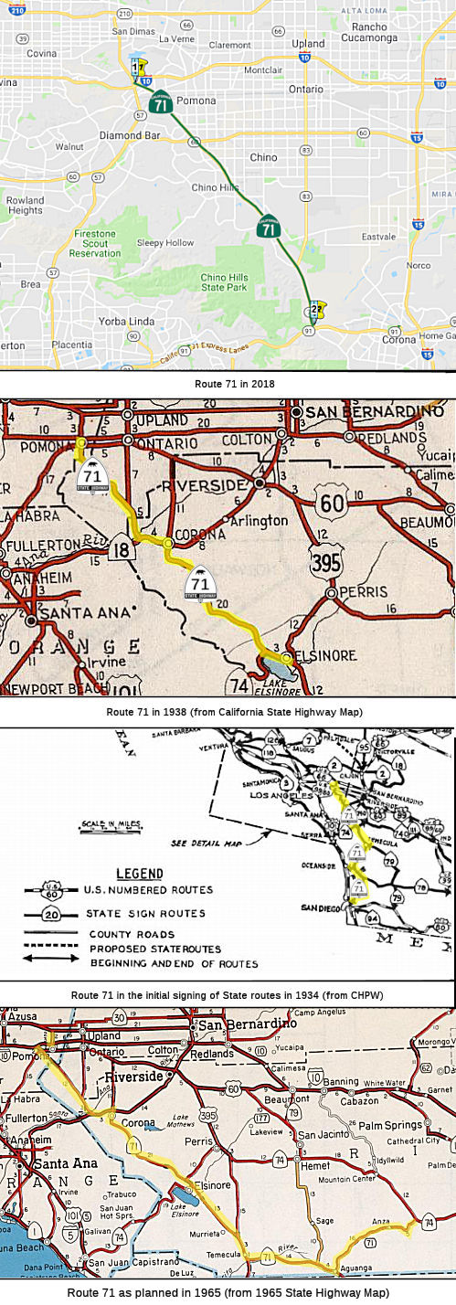 From Route
  Former Route 71
 Route 70
 Route 72