
 California Highways:
Click here for a key to the symbols used. An explanation of acronyms may be found at the bottom of the page.
 Routing
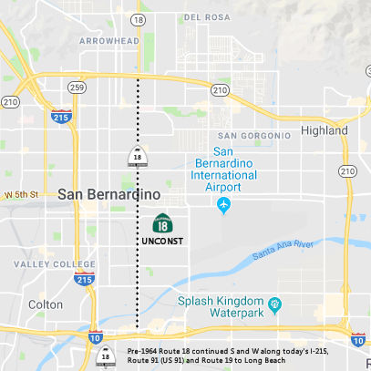 From Route 10 near San Bernardino to Route 210.
 Unconstructed (5 miles). The freeway route adoption was rescinded in 1975. At that time the need for Route 18 southerly of then
Route 30 (now Route 210) was a low priority. The portion N of Route 10
(Harrison Canyon Alignment) is needed to meet traffic demands (Waterman
Ave.). No local roads adequately fit the description of a traversable
highway.
Unconstructed (5 miles). The freeway route adoption was rescinded in 1975. At that time the need for Route 18 southerly of then
Route 30 (now Route 210) was a low priority. The portion N of Route 10
(Harrison Canyon Alignment) is needed to meet traffic demands (Waterman
Ave.). No local roads adequately fit the description of a traversable
highway.
The 2013 Traversable Highway report notes that, for this segment, freeway route adoption was rescinded in 1975, after a route adoption review in 1974. Because Route 215, Route 259 and Route 210, exist in the area and are parallel north - south freeways, the need for Route 18 southerly of Route 210 to be a state highway is a low priority. No local roads adequately fit the description of a traversable highway.
 Post 1964 Signage History
▸In 1963, this route was a single segment, and was defined as "from Route 10 near San Bernardino to Route 138 via San Bernardino, near Mountain View Avenue and via Waterman Canyon, Big Bear Lake, Baldwin Lake, and near Victorville."
Scott Parker on AARoads provided some insight on the 1963 definition:
(Source: Sparker on AARoads, "Re: CA 259", 5/24/2019)
Before the 1958-59 construction of the (then) I-15 (now I-215) freeway north from I-10 into central San Bernardino, Pre-1964 Route 18 (aka LRN 43) took a convoluted path through downtown: coming into town multiplexed with US 91 & US 395 on Mt. Vernon St., then turning right on 3rd Street (at the south end of the old Mt. Vernon bridge over the Santa Fe yards) to E Street, then turning north on E to Highland (LRN 190/Route 30). It then turned right on Highland a few blocks to Sierra, turning north until that street segued into the original 2-lane Route 18 up into the mountains. Two things happened with the '64 renumbering: new Route 18 came out of the mountains (SB) and at least was intended to temporarily terminate at Route 30; a typical Division of Highways/Caltrans unadopted "dotted line on a map" showed Route 18 extending south more or less along Waterman Ave., the major N-S arterial in the area, all the way to I-10 in the Loma Linda area between Colton and Redlands. When Route 18 was improved in the mountains (opened in early '71) to a 4-lane expressway, its "flatland" alignment was in fact shifted a few blocks east to Waterman Ave. rather than the previous Sierra alignment, because the latter could not easily be expanded to 4 lanes, while Waterman could. Curiously, Sierra was signed as "Business Route 18" -- although it traversed a decidedly residential neighborhood. Route 18 was signed down to the then-Route 30 freeway; initially signage took it west on Route 30 to the present Route 259 "cutoff", then right over that freeway to a terminus at (then) I-15 (which became I-15E at the end of 1972 and I-215 ten years later). Somewhere in the mid-70's any Route 18 signage -- reassurance or trailblazer -- was removed south/west of the Waterman Ave. interchange with Route 30; signage from I-15E/I-215 NB onto Route 259 was "TO Route 30 EAST" with a secondary line "TO Route 18/MOUNTAIN RESORTS"; from Route 30 WB it was "TO I-15E(I-215) SOUTH". Variations on that signage persisted even when Route 30 was extended west to I-215 and east to Redlands (and Route 330) by 1992; [even by 2012] the configuration was the same (but now referring to Route 210 rather than Route 30, of course). The gist of the matter was that originally Route 18 was intended to extend south across the east end of San Bernardino; as that never occurred, Route 259 remains part of the most direct connection between much of the regional freeway network (210 to the west notwithstanding) and the main artery up the mountain to the Crestline/Lake Arrowhead area -- essentially functioning, as it has since its opening in the late '60's, as a natural extension of Route 18.
▸In 1965, the definition was relaxed to "Route 10 near San Bernardino to Route 138 via San Bernardino, Waterman Canyon, Big Bear Lake, Baldwin Lake, and near Victorville."
 In 1974, hearings were held by Caltrans on the question
of whether planning for the unconstructed portion of Route 18 (called the
"Harrison Street Freeway") should be continued. There were two segments
that had been adopted previously: a segment N of Route 210 (Route 30) and
the segment between I-10 and Route 210. At the time, there were no plans
nor funds to construct the freeway, and so planning for construction just
hindered development.
In 1974, hearings were held by Caltrans on the question
of whether planning for the unconstructed portion of Route 18 (called the
"Harrison Street Freeway") should be continued. There were two segments
that had been adopted previously: a segment N of Route 210 (Route 30) and
the segment between I-10 and Route 210. At the time, there were no plans
nor funds to construct the freeway, and so planning for construction just
hindered development.
(Redlands Daily Facts, 11/28/1974 via Joel Windmiller, 1/29/2023;
Image Source: San Bernardino County Sun, 11/27/1974, via Joel Windmiller
2/25/2023)
▸In 1984, Chapter 409 split the definition into two parts: (a) Route 10 near San Bernardino to Route 15 via San Bernardino, Big Bear Lake, and Victorville. (b) Route 15 to Route 138.
▸In 1986, Chapter 928 tightened the language for this segment to be "Route 15 in Victorville via Big Bear Lake".
▸In 1994, Chapter 1220 split the segment again into "(a) Route 10 near San Bernardino to Route 30. (b) Route 10 [sic] near San Bernardino to Route 15 in Victorville via Big Bear Lake." AB 1650, Ch 724, 10/10/99, corrected the reference to Route 30, which had been renumbered as Route 210.
 Pre 1964 Signage History
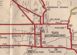 In 1934, Route 18 was signed
along the route from Jct. Route 19 near Artesia to Victorville, via San
Bernardino and Big Bear Lake. The portion of this route from I-10 to San
Bernardino was originally part of LRN 26, defined in 1916, as part of a
spur off of LRN 26 from Colton to connect to San Bernardino (presumably,
as a county seat) ["together with a connection from near Colton to San
Bernardino"]. In 1959, this segment was redefined to be LRN 275, and the
spur that was part of LRN 26 was deleted. The 1959 LRN 275 also extended
the route to Route 30 (now I-210), as the spur had only gone as far as LRN 9 (US 66).
In 1934, Route 18 was signed
along the route from Jct. Route 19 near Artesia to Victorville, via San
Bernardino and Big Bear Lake. The portion of this route from I-10 to San
Bernardino was originally part of LRN 26, defined in 1916, as part of a
spur off of LRN 26 from Colton to connect to San Bernardino (presumably,
as a county seat) ["together with a connection from near Colton to San
Bernardino"]. In 1959, this segment was redefined to be LRN 275, and the
spur that was part of LRN 26 was deleted. The 1959 LRN 275 also extended
the route to Route 30 (now I-210), as the spur had only gone as far as LRN 9 (US 66).
Note: See the history of US 99 in San Bernardino for more information on the historical routing of Route 18.
Pre-1964 Route 18 South and West of I-10
 As noted above, in 1934, Route 18 was signed along the route from Jct. Route 19 (Lakewood Blvd)
near Artesia to Victorville, via San Bernardino and Big Bear Lake. In
1963, it was truncated to start at I-10. This routing ran along LRN 178
between Sign Route 19 and LRN 43 in Santa Ana Canyon, and then along LRN 43 to San Bernardino.
As noted above, in 1934, Route 18 was signed along the route from Jct. Route 19 (Lakewood Blvd)
near Artesia to Victorville, via San Bernardino and Big Bear Lake. In
1963, it was truncated to start at I-10. This routing ran along LRN 178
between Sign Route 19 and LRN 43 in Santa Ana Canyon, and then along LRN 43 to San Bernardino.
See also the pages on US 91 and Route 214 for more history of this segment.
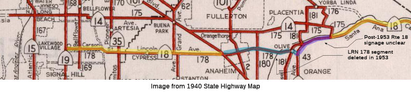
South of San Bernardino, until at least 1961, Route 18 continued S through Colton to Lakewood, along the routes of the current Route 215 to Riverside, and Route 91 and Route 55 to Anaheim-Olive (which later became Lincoln Blvd near Olive. then W along Anaheim Olive (now Lincoln), Center Street (Lincoln), and Lincoln Ave to Lakewood Blvd.
LRN 178 was defined in 1933 as "Cerritos Avenue to [LRN 43] near Olive
via Anaheim" Cerritos Avenue was later renamed Lakewood Avenue; LRN 43 was
to become Sign Route 18 (briefly) and then US 91. The route followed
Carson Street, Lincoln Avenue and Center Street (now Lincoln Avenue in
Anaheim) between Lakewood Ave (Sign Route 19/LRN 168) and LRN 43. In 1934,
this became part of Sign Route 18. In 1947, AASHO approved the extension
of US 91 from Barstow to Long Beach. The extension of US 91 to Long
Beach was created from a multiplex of LRN 43/Sign Route 18 (which became
US 91), LRN 178/Sign Route 18 along Lincoln Avenue, Sign Route 19/LRN 168
to Los Alamitos Traffic Circle, and west on US 101A/LRN 60 on Pacific
Coast Highway. In 1953, LRN 178 was truncated to the new mainline of
US 101 at Manchester Avenue/LRN 174. This removed the segment of LRN 178 between US 101/LRN 174 east through Anaheim to US 91/LRN 43. At
this tims, US 91 and Sign Route 18 were still routed along Center Street
in Anaheim and Olive. By 1956, US 91/Sign Route 18 were rerouted
from the eastern terminus of LRN 178 onto US 101/LRN 174 and then along
Sign Route 14/LRN 175 towards US 91/LRN 43 in Santa Ana Canyon. In
1957, the legislature clarified the end points of LRN 178 as "LRN 168
(Sign Route 19) near Lakewood and LRN 174 (US 101) near Anaheim." In 1961,
Sign Route 18 was truncated to San Bernardino, leaving US 91 as the only
Sign Route on LRN 178. In 1963, US 91 was truncated to Barstow; in 1964,
former US 91 in Santa Ana Canyon and along Sign Route 14 became Route 91,
and LRN 178 became Route 214. Route 214 was to be deleted once the Route 91 freeway was completed.
(Source: Gribblenation Blog (Tom Fearer), "Former California State Route 214 (former California State Route 18 and US Route 91)", 6/14/2023)
During 1933, LRN 178 and LRN 174 were defined as highways passing through
Anaheim. LRN 178 was defined as from "Cerritos Avenue to LRN 43 near
Olive via Anaheim." LRN 174 was defined as "LRN 60 via Manchester
Avenue to LRN 2/US Route 101 near Miraflores." LRN 178 (Sign Route 18) would pass through the city of Anaheim via Center Street (partially
now Lincoln Avenue), whereas LRN 174 (Sign Route 10) was part of the then
unfinished Manchester Boulevard Extension. By 1942, Sign Route 10
had been truncated to an eastern terminus at US 101 Bypass/Sign Route 19
at Rosemead Boulevard in Downey. On July 1, 1947, the AASHO Executive
Secretary notified the California State Highway Engineer that California's
request to extend US 91 from Barstow to Long Beach had been approved; this
extension brought it through Anaheim along Center Street via a multiplex
of Sign Route 18/LRN 178. In 1953, the eastern terminus of LRN 178 was
truncated to the new mainline routing of US 101 along Manchester Boulevard
in Anaheim. Despite LRN 178 being relinquished between US 101/LRN 174 and LRN 43, it was still signed as US 91/Sign Route 18 through Anaheim
via Center Street. By 1956, US 91 and Sign Route 18 were realigned
onto Sign Route 14/LRN 175 north of downtown Anaheim. The interim
routing of US 91/Sign Route 18 from Lincoln Avenue followed US 101/Manchester Boulevard, Orangethorpe Avenue, Cypress Avenue (now State
College Boulevard) and a completed segment of the Riverside (Orangethorpe)
Freeway (east of LRN 180). In 1956, the Riverside Freeway (Houston
Expressway) (Sign Route 14/US 91/Sign Route 18/LRN 175) opened east of LRN 180/Cypress Avenue to Santa Ana Canyon. By 1957, Sign Route 18 and US 91
were realigned onto the Stanton Avenue Extension along Sign Route 39/LRN 171 in Buena Park. Both highways briefly multiplexed US 101 towards
Sign Route 14/LRN 175 on Orangethorpe Boulevard. In 1962, Sign Route 18
was truncated from Long Beach to San Bernardino. This truncation removed
it from US 91/Sign Route 14/LRN 175 on the Riverside Freeway north of
downtown Anaheim.
(Source: Gribblenation Blog (Tom Fearer), "Former US Route 101, US Route 91, California State Route 10 and California State Route 18 in Anaheim", 9/26/2023)
In 1953, the underlying LRN along Lincoln between Route 55 and US 101 was deleted. It appears that Route 18 signage in the wild along Lincoln may have been retained along city streets, but the state highway maps show Route 18 ending at the jct. with LRN 175 (Imperial Highway, later the Riverside Freeway), and then picking up along Lincoln W of Manchester. The focus of the Department of Highways at the time was signing US 91. After 1953, US 91 was routing along LRN 175 westward to varying degrees depending on the completion of the freeway, heading back down S to pick up the original LRN 178 (Route 18) routing at an appropriate N/S lateral (State College, LRN 180; Brookhurst St; Manchester, Byp US 101).
W of US 101, Route 18 was supposedly signed with US 91 to Lakewood Blvd. This routing was LRN 178. The route was defined in 1933. In the 1963 renumbering, this became Route 214.
 From Route 210 near San Bernardino to Route 15 in
Victorville via Big Bear Lake.
From Route 210 near San Bernardino to Route 15 in
Victorville via Big Bear Lake.
Post 1964 Signage History▸This segment was created in 1994 (Chapter 1220) from a split of former segment (a), which was created in 1984 and tighted in 1986. Former segment (a) in 1986 read: "(a) Route 10 near San Bernardino to Route 15 in Victorville via Big Bear Lake.". It was split into "(a) Route 10 near San Bernardino to Route 30. (b) Route 10 [sic] near San Bernardino to Route 15 in Victorville via Big Bear Lake." In 1996, Chapter 1154 changed "Route 10" to "Route 30".
Additionally, the original routing was relocated to Lakeview Drive in Big Bear Lake per the route adoption dated 5/23/91.
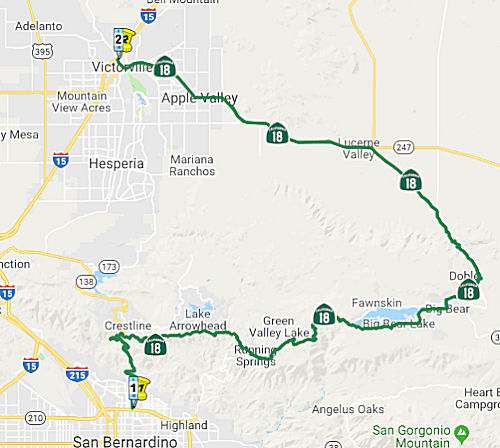
Note that a big numbering switch also occured in 1964. Prior to 1964, Route 18 ran N from San Bernardino. At Running Springs, it joined with Route 30 (now Route 330) up from Highland, and continued cosigned Route 18/Route 30 to the W end of Big Bear Lake. At this point, Route 30 ran along the S edge of the lake, and Route 18 ran along the N end. When the new definitions went into place, Route 18 was rerouted to the S side of Big Bear Lake (replacing what had been signed as Route 30). The cosigning that existed between the W end of Big Bear Lake and the Route 30 (now Route 330)/Route 18 junction was eliminated, and the route was just signed as Route 18. The old Route 18 routing on the N side of the lake was signed as Route 38.
Pre 1964 Signage HistoryIn 1934, Route 18 was signed along the route from Jct. Route 19 near Artesia to Victorville, via San Bernardino and Big Bear Lake. Before 1964, this segment was LRN 43. The segment between Route 30 and Big Bear Lake dates to 1917 (when it was Crest Drive; later Rim of the World Highway) the remainder was an extension defined in 1933 (note that LRN 43 actually covered both the northern and southern routes along the Big Bear Lake — the northern routing, defined in 1931, was later renumbered Route 38).
Crest Drive/Rim of the World Highway was initially constructed in 1852 as
a logging road by Mormon settlers in what is now modern day San Bernardino
County. Crest Drive became suddenly increasingly important following the
discovery of Gold in Holcomb Valley located near modern day Bear Lake. A
large town known as Belleville developed around the Holcomb Valley mining
claims. Growth in Belleville was so rapid that it almost took the San
Bernardino County seat from San Bernardino. Although the Gold Rush in
Holcomb Valley last about a decade mining continued in the area until the
1910s. By the turn of the 20th Century the crest of the San Bernardino
Mountains had become an increasingly popular locale for recreation. It
appears that one of the primary drivers in adding Crest Drive to the State
Highway system was likely to eliminate the toll facility in the area. A
1919 Third State Highway Bond Act measure extended LRN 43 over Bear Valley
Dam, this is reflected on the 1920 State Highway Map. Previously LRN 43
had been routed north of Bear Lake (which would become part of Route 38).
(Source: Gribblenation Blog - California State Route 18; the Rim of the World Highway to California State Route 138)
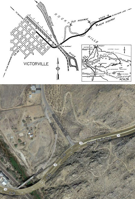 Victorville provides another example of a rerouting in
the late 1940s to eliminate a number of dangerous curves. Note from these
comparison maps how the old Route 18 is still visible as a dirt trail near
the current highway. The previous Route 18 routing had seventeen curves,
some of them "hairpin" variety with radii as short as 50 feet that made it
impossible for trucks and trailers to negotiate them without blocking
traffic or risking collision. The revised routing has four curves of easy
transition ranging in radii from 1,000 to 2,000 feet designed for a safe
driving speed of 50mph.
Victorville provides another example of a rerouting in
the late 1940s to eliminate a number of dangerous curves. Note from these
comparison maps how the old Route 18 is still visible as a dirt trail near
the current highway. The previous Route 18 routing had seventeen curves,
some of them "hairpin" variety with radii as short as 50 feet that made it
impossible for trucks and trailers to negotiate them without blocking
traffic or risking collision. The revised routing has four curves of easy
transition ranging in radii from 1,000 to 2,000 feet designed for a safe
driving speed of 50mph.
Tom Fearer provided a chronology of the mountain routings:
(Source: Tom Fearer (Max R) on AARoad, "Re: CA 18", 10/1/2019)
 Status
In September 2012, it was reported that the Caltrans has ordered the CHP to make the 26-mile stretch of Route 18 between Route 138 and Route 38 (~ SBD R17.216 to SBD 44.411) a Daylight Headlight Section. Fines for violations could be as high as $350. The Daylight Headlight Section came about because of a request from community members made during the second annual Community Preparedness Meeting and Open House in 2011 in Lake Arrowhead.
![[Route 18 Bridge Replacement]](maps/018-bridge-repl.jpg) In April 2006, the CTC heard the
results of a draft EIR related to replacement of an existing bridge near
Big Bear in San Bernardino County (SBD PM 44.2/44.7). This project is
programmed in the 2006 State Highway Operation and Protection Program. The
total estimated project cost is $58,314,000. Construction is estimated to
begin in Fiscal Year 2007-08. The following alternative are being
considered: (•) Alternative 4 - "Lake Crossing", which
proposes to construct a new three-lane bridge across the western end of
Big Bear Lake that would widen and realign the approach to accommodate the
new structure and eliminate a substandard curve on Route 18, as well as
signalization of the intersection of Route 18 and Route 38 to improve
channelization during peak hour traffic on weekends and holidays,
(•) Alternative 5 - "Canyon Crossing", which proposes to
construct a new three-lane bridge across Bear Lake Canyon, widening and
realigning the approach to accommodate the new structure and realign a
substandard curve on Route 18, as well as signalization of the
intersection of Route 18 and Route 38 to improve channelization during
peak hour traffic on weekends and holidays, or (•) No-Build
Alternative. Because Route 18 and Route 38 are part of the United States
Forest Service (USFS) scenic byway system and are eligible for listing as
State Scenic Highways, any activities that could alter aesthetics are
considered significant. The proposed project will remove mature trees and
modify large rock outcroppings in the area. It will also modify the
gateway view of Big Bear Lake by introducing new and larger transportation
elements.
In April 2006, the CTC heard the
results of a draft EIR related to replacement of an existing bridge near
Big Bear in San Bernardino County (SBD PM 44.2/44.7). This project is
programmed in the 2006 State Highway Operation and Protection Program. The
total estimated project cost is $58,314,000. Construction is estimated to
begin in Fiscal Year 2007-08. The following alternative are being
considered: (•) Alternative 4 - "Lake Crossing", which
proposes to construct a new three-lane bridge across the western end of
Big Bear Lake that would widen and realign the approach to accommodate the
new structure and eliminate a substandard curve on Route 18, as well as
signalization of the intersection of Route 18 and Route 38 to improve
channelization during peak hour traffic on weekends and holidays,
(•) Alternative 5 - "Canyon Crossing", which proposes to
construct a new three-lane bridge across Bear Lake Canyon, widening and
realigning the approach to accommodate the new structure and realign a
substandard curve on Route 18, as well as signalization of the
intersection of Route 18 and Route 38 to improve channelization during
peak hour traffic on weekends and holidays, or (•) No-Build
Alternative. Because Route 18 and Route 38 are part of the United States
Forest Service (USFS) scenic byway system and are eligible for listing as
State Scenic Highways, any activities that could alter aesthetics are
considered significant. The proposed project will remove mature trees and
modify large rock outcroppings in the area. It will also modify the
gateway view of Big Bear Lake by introducing new and larger transportation
elements.
In August 2015, the CTC approved $3,296,000 for a project in San Bernardino County, on Route 18 (08-SBd-18, 49.1/51.6) in Big Bear Lake, from Pine Knot Avenue to Stanfield cutoff that will construct auxiliary lanes in both directions to reduce congestion and improve highway operations and mobility.
Cushenberry Creek Bridge (SBD 64.60)
In May 2009, the CTC approved for future consideration of funding a project that will replace the existing Cushenberry Creek Bridge (SBD 064.60) on a new alignment, remove the existing bridge, improve drainage, and construct roadway improvements near Lucerne Valley. The project is fully funded and is programmed in the 2008 State Highway Operation and Protection Program. Total estimated project cost is $11,639,000, capital and support. Construction is estimated to begin in Fiscal Year 2009-10.
In August 2011, the CTC approved $100,000 in SHOPP funding for repairs near Lucerne Valley, at Cushenbury Creek Bridge, that will provide landscape mitigation covering one acre area at one bridge replacement project site. Project will maintain existing plants for four years to facilitate plant establishment.
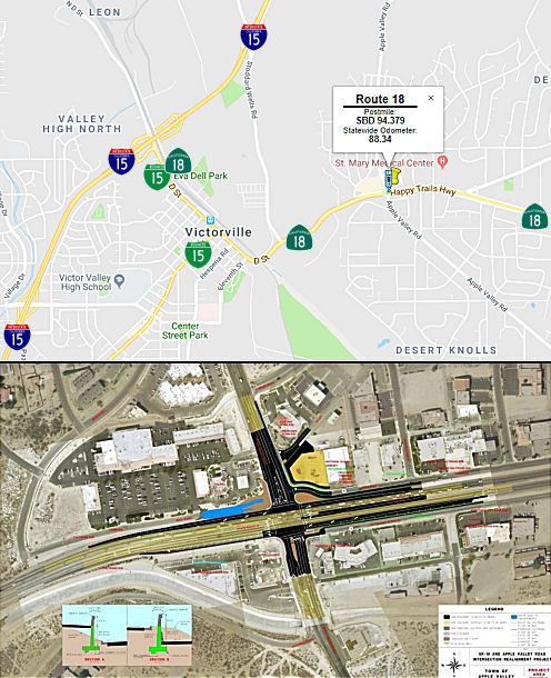
Realignment - Apple Valley to Adelanto (~SBD 86.886 to SBD 100.873)
Portions of this routing may be affected by the High Desert Corridor; see Route 138 for a discussion of the HDC. According to SANBAG, the City of Victorville has secured Federal Demonstration funds for the Project Approval and Environmental Document (PA&ED) phase of the High Desert Corridor project. The project realigns Route 18 to a new alignment from Joshua Road in the Town of Apple Valley (~SBD 86.886) to US 395 in the City of Adelanto (~ SBD 100.873). The new facility will be a four-lane expressway. The project is the first phase of the eventual High Desert Corridor linking the Victor Valley to the Antelope Valley.
Route 18 is a two-lane street with a continuous center turn lane in the Town of Apple Valley and City of Victorville (D Street). When Route 18 junctions with I-15, travelers must follow I-15 south to Palmdale Road, where Route 18 proceeds west. Palmdale Road is a four-lane street until it leaves the city, at which time it becomes a two-lane conventional highway until it terminates at Route 138 in Los Angeles County. The project will realign Route 18 from Joshua Road in the Town of Apple Valley to US 395 in the City of Adelanto. The proposed alignment proceeds north until it nears the Apple Valley Airport, where it turns west. The alignment continues west until it links with Air Expressway near Southern California Logistics Airport in the City of Victorville and proceeds on to US 395. The new facility will be a four-lane expressway with at-grade intersections from Joshua Road to I-15, and will include an interchange at I-15. From I-15 to US 395, the facility will be a four-lane freeway with grade separated interchanges at Phantom East and either Adelanto Road or existing US 395.
Reconstruction - Route 18 and Apple Valley Road (08-SBd-18, PM 94.2/96.6)
 In the SB1 Project List, as of June 2018, under the Local Streets and Roads program, the following
appears: Rt 18 West End Widening/Ph1 - Apple Valley Rd Realignment:
Widening Route 18 from four to six lanes; realign and widening Apple
Valley Road; modify existing drainage system; replace existing traffic
signal; new retaining wall; curb and sidewalk improvements. $4,450,000.
In the SB1 Project List, as of June 2018, under the Local Streets and Roads program, the following
appears: Rt 18 West End Widening/Ph1 - Apple Valley Rd Realignment:
Widening Route 18 from four to six lanes; realign and widening Apple
Valley Road; modify existing drainage system; replace existing traffic
signal; new retaining wall; curb and sidewalk improvements. $4,450,000.
In February 2019, it was reported that Town Council
action has restarted a decade-old road construction project at the
intersection of Route 18 and Apple Valley Road. Council members approved a
contract amendment on Jan. 22, 2019 for pre-construction work related to
an overhaul of the intersection. The $491,366 amendment represents a
not-to-exceed amount paid to Dokken Engineering for environmental and
design services. The project is expected to widen the highway to six
lanes, and Apple Valley Road to four lanes, among other improvements. The
amendment increases Dokken’s total contract to more than $1.3
million for a combination of tasks that includes project management. The
initial contract was approved Nov. 18, 2008, for a not-to-exceed amount of
$417,000, town documents show. Dokken’s latest proposal had been in
process for about a year and a half. A nearly $4.5 million California
Transportation Commission grant and right-of-way acquisition from the
state allowed for its consideration. Dokken completed 95 percent of the
planning and design work between 2011 and 2014, but the project was put on
hold in 2015 due to a lack of available funding for construction. The $4.5
million secured in 2018 through the CTC’s Local Partnership Program,
created via passage of Senate Bill 1 in 2017, meant the project could
again move forward. At the time, Town officials estimated a summer 2019
start for construction. But “all the environmental studies, all of
the reviews, a lot of the water-quality regulations have changed”
since 2014. In addition to widening Route 18 and Apple Valley Road,
construction will eliminate Wika Road, a frontage road at the
intersection’s northwest corner, according to a previous Daily Press
report. Outer Highway 18 will be changed to a one-way road at the
southeast corner. Grade changes along the roadway will be reduced, as
well. Residents can also expect new traffic signals, storm drain
installation, improved signage, retaining walls, additional crosswalks and
sidewalks, among other upgrades. The project is currently valued at
approximately 8 million, town documents show. Grant funds will be matched
with San Bernardino County Transportation Authority Measure I funds and
Apple Valley Transportation Impact Fees to cover costs. “It’s
almost hard to imagine how complex this project will be and how hard it is
to design,” according to the Town Manager. “This intersection
is the busiest intersection in town. There are very few alternate routes,
and the construction-phasing aspect of it is going to be trying to keep
the number of lanes open that we have on a normal day during
construction.”
(Source: Victor Valley Daily Press, 2/5/2019)
In May 2020, the CTC approved for future consideration
of funding the State Route 18/Apple Valley Road Intersection
Realignment Project (08-SBd-18, PM 94.2/96.6), which will widen and
realign the Apple Valley Road Approach to the Route 18/Apple Valley Road
Intersection in San Bernardino County. (PPNO 3010U). The project is
located in the Town of Apple Valley on Route 18 in San Bernardino County.
The objective of the project is to widen and realign the Apple Valley Road
approach to the Route 18/Apple Valley Road intersection to reduce
excessive vehicle delays and improve traffic operations. This project is
fully funded and currently programmed in the 2018 Senate Bill 1 (SB 1)
Local Partnership Program (LPP) for a total of $8,900,000 in LPP funds and
Local funds. Construction is estimated to begin fiscal year 2019-2020. The
scope, as described for the preferred alternative, is consistent with the
project scope programmed by the California Transportation Commission
(Commission) in the 2018 SB 1 LPP.
(Source: May 2020 CTC Agenda, Agenda Item 2.2c.(1))
In May 2020, the CTC approved the following STIP
allocation: $4,450,000. 08-SBd-18 94.2/94.6. PPNO 08-3010U. ProjID
0818000194 EA 0G920. Route 18 West End Widening- Phase 1 Apple Valley Road
Realignment. In the town of Apple Valley, at the intersection of Route 18
and Apple Valley Road. Widen Route 18, realign and widen Apple Valley
Road, upgrade/modify existing drainage system, replace existing traffic
signal and construct various sidewalk improvements. Allocation:
CONST $4,450,000.
(Source: May 2020 CTC Agenda, Agenda Item 2.5s.(2))
In August 2020, the CTC received notice of the following delegated
allocation: $8,032,000. 08-SBd-18 97.0/99.5. PPNO 08-3006F ProjID
0813000140 EA 1E060. Route 18 In and near Victorville, from Amargosa Road
to Cobalt Road. Outcome/Output: Improve safety by constructing raised curb
median, widening roadway, and installing traffic signal. This project will
reduce the number and severity of collisions.
(Source: August 2020 CTC Agenda, Agenda Item
2.5f.(3) #8)
 Naming
"Rim of the World" Highway; "North Shore" Drive; "Big Bear Blvd.", "Lakeview Dr." and "Paine Rd.".
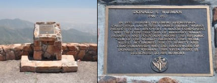 On Route 18 in San Bernardino County, at PM SBD
21.4, two miles south of the City of Rimforest, may be found the Donald
S. Wieman Vista Point. It was named in honor of Donald S. Wieman, a
native Californian (b. 1900), who was a skilled stone mason and building
contractor in the Glendale, California area. He moved to San Bernardino in
1932 to work for the California Division of Highways and was responsible
for constructing miles of red rock walls and other structures along Route 18, also known as the Rim of the World Highway. This masonry work was part
of a major state public works program aimed at recovery from the Great
Depression. He rose through the ranks of the Division of Highways to the
position of Maintenance Superintendent, Special Crews, from which he
retired in 1965. The historical marker reads as follows: "Donald S. Wieman
/ 1900 - 1977 / In 1932, during the Great Depression, California launched
a large public works project to aid recovery. A major component was the
construction of masonry walls, parapets and fountains along the historic
"Rim of the World" highway. This work, widely acclaimed for its beauty and
craftsmanship, was the handiwork of Donald S. Wieman. This vista point is
dedicated to his memory." Named by Assembly Concurrent Resolution 248,
Chapter 195, September 16, 2004.
On Route 18 in San Bernardino County, at PM SBD
21.4, two miles south of the City of Rimforest, may be found the Donald
S. Wieman Vista Point. It was named in honor of Donald S. Wieman, a
native Californian (b. 1900), who was a skilled stone mason and building
contractor in the Glendale, California area. He moved to San Bernardino in
1932 to work for the California Division of Highways and was responsible
for constructing miles of red rock walls and other structures along Route 18, also known as the Rim of the World Highway. This masonry work was part
of a major state public works program aimed at recovery from the Great
Depression. He rose through the ranks of the Division of Highways to the
position of Maintenance Superintendent, Special Crews, from which he
retired in 1965. The historical marker reads as follows: "Donald S. Wieman
/ 1900 - 1977 / In 1932, during the Great Depression, California launched
a large public works project to aid recovery. A major component was the
construction of masonry walls, parapets and fountains along the historic
"Rim of the World" highway. This work, widely acclaimed for its beauty and
craftsmanship, was the handiwork of Donald S. Wieman. This vista point is
dedicated to his memory." Named by Assembly Concurrent Resolution 248,
Chapter 195, September 16, 2004.
(Image source: Historical Marker Database)
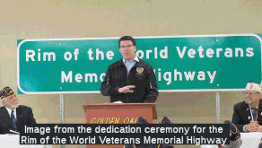 The segment of this route in the County of San Bernardino, beginning at the intersection of Route 18 and Route 330 and
continuing toward Big Bear Lake for 4.5 miles (~ SBD 31.548 to SBD
36.048), is designated the "Rim of the World Veterans Memorial Highway".
It was named in honor of the nearly two million veterans that reside in
the State of California, and particularly those veterans who live in the
San Bernardino Mountains. The naming was spearheaded by the American Legion Post 360 and the Veterans of Foreign Wars Post 9624, who partnered to sponsor the “Rim of
the World Veterans Memorial Highway” designation in honor of those
who have dedicated their lives to the service of this nation. Named by
Assembly Concurrent Resolution (ACR) 21, Res. Chapter 87, Statutes of
2015, on July 1, 2015.
The segment of this route in the County of San Bernardino, beginning at the intersection of Route 18 and Route 330 and
continuing toward Big Bear Lake for 4.5 miles (~ SBD 31.548 to SBD
36.048), is designated the "Rim of the World Veterans Memorial Highway".
It was named in honor of the nearly two million veterans that reside in
the State of California, and particularly those veterans who live in the
San Bernardino Mountains. The naming was spearheaded by the American Legion Post 360 and the Veterans of Foreign Wars Post 9624, who partnered to sponsor the “Rim of
the World Veterans Memorial Highway” designation in honor of those
who have dedicated their lives to the service of this nation. Named by
Assembly Concurrent Resolution (ACR) 21, Res. Chapter 87, Statutes of
2015, on July 1, 2015.
(Image source: Alpenhorn News)
The segment of this route in the City of Apple Valley (~SBD 86.844 to SBD 95.395) is officially named the "Happy Trails Highway". It was named by Assembly Concurrent Resolution 82, Chapter 80, in 1992. Happy Trails was the song and slogan made famous by Roy Rodgers and his wife, Dale Evens, both residents of Apple Valley. More information on Roy Rodgers can be found at the Roy Rodgers-Dale Evens Website. The Roy Rodgers Museum was located in Victorville, CA, until March 2003.
 Business Routes
This route appears to have a business route on Sierra Way in San Bernardino, N of Route 210. Cameron Kaiser reports that, as of May 2009, Business Route 18, appears to be quite alive. There has been some evidence of sign replacement on Sierra Way, including a brand-new Rourte 18 and BUSINESS banner just past the bridge at Sierra and 30th.
The old routing of Route 18 through the Village in Big Bear is signed both officially and unofficially as Business Route 18.
 Scenic Route
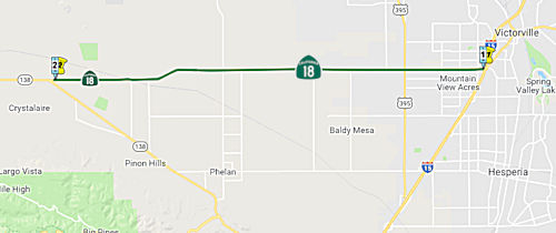 From Route 15 near Victorville to Route 138 near Pearblossom.
Post 1964 Signage History▸In 1963, this segment was part of the larger Route 18 that ran "from Route 10 near San Bernardino to Route 138 via San Bernardino, near Mountain View Avenue and via Waterman Canyon, Big Bear Lake, Baldwin Lake, and near Victorville." This definition was relaxed in 1965 to "Route 10 near San Bernardino to Route 138 via San Bernardino, Waterman Canyon, Big Bear Lake, Baldwin Lake, and near Victorville."
Scott Parker on AARoads noted: The western extension of Route 18 from
I-15 to Route 138 in L.A. County was, prior to its adoption into the state
highway system in late '67, a well-used county facility. Bringing that
road into the system at that particular time was prompted by Southern
Pacific's construction of their Palmdale-Colton "cutoff" line enabling
freight traffic to bypass central L.A. The tracks would have crossed that
road at a very sharp angle, generally considered the most dangerous
crossing type; San Bernardino County was reluctant (and short of available
funds) to pay for a road overpass, so they petitioned the Division of
Highways to adopt the road; it was close to the unadopted Route 18
extension -- but at the time the Division preferred a new-terrain
alignment a bit to the north of that road. But the county was persistent,
so in late 1965 the Division "caved" and agreed to take the road into the
system and construct an overpass over the new SP line. When the bridge was
completed in the fall of '67, the adoption was formalized. But even then
signage was sporadic, mostly clustered at I-15 and Route 138 as well as
the US 395 "crossroads" in west Victorville; reassurance shields were, for
the most part, absent apart from those junctions.
(Source: Scott Parker on AARoads, "Re: CA 18", 10/2/2019)
▸In 1984, Chapter 409 split the definition into two parts: (a) Route 10 near San Bernardino to Route 15 via San Bernardino, Big Bear Lake, and Victorville. (b) Route 15 to Route 138.
▸In 1986, Chapter 928 tightened the language for this segment: "Route 15 near Victorville to Route 138 near Pearblossom."
This segment was planned as freeway in 1965; never upgraded. It may be part of the High Desert Corridor.
Pre 1964 Signage HistoryThis segment was not signed as part of Route 18 until 1967. It was LRN 268, and was defined in 1959. It wasn't constructed until after 1967.
StatusIn April 2019, it was reported that construction on a new raised curb
median along Palmdale Road (Route 18) between Cobalt Road in Victorville
and US 395 (~ SBD 99.451 to SBD 100.984) was starting in May 2019. The $15
million project will construct a raised curb median and include the
reconfiguration of left turn pockets to enhance safety and help eliminate
cross-median collisions. The project is expected to be complete in summer
2020. Weather conditions may affect the completion date of this project.
Construction on the project began 7/15/2019
(Source: Victorville News, 4/24/2019; CaltransCommuter
Alert, 7/3/2019)
Route 18 Rumble Strip Project (08-SBd-18, PM 101.5/115.9)
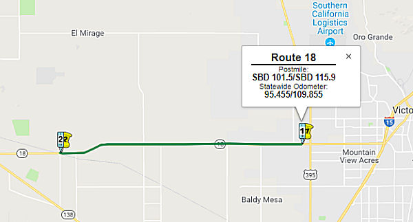 In March 2018, a Draft EIR was released for a proposed safety project to widen the shoulders and
install rumble strips on Route 18. The project would occur between SBD
101.5 in the City of Adelanto (0.5 mi W of US 395) and SBD 115.9 on the
northern edge of unincorporated Pinon Hills (this is the LA County Line,
near the point where Route 138 and Route 18 meet). The eastern 2.4 miles
of this highway segment are located within the City of Adelanto and the
remaining 12.0 miles of this roadway segment is situated within
unincorporated San Bernardino County. The project proposes to build a 4
foot median buffer, widen existing shoulders to 8 feet, and add centerline
and shoulder rumble strips to both sides of the roadway. The project will
also replace existing dikes, install new guardrail as necessary, and
extend or replace existing culverts. The purpose of the proposed project
is to warn and/or alert distracted motorists about the imminent potential
for crossing the centerline into oncoming traffic and/or crossing onto the
shoulder. The centerline rumble strip and shoulder rumble strip will
generate an audible noise and rumble effect when tires pass over it to
warn drivers to take corrective action to bring the vehicle back in the
lane. Replacing the existing pavement markers and re-striping will enhance
the visibility and delineation of the pavement. The proposed project is
expected result in a reduction of cross-centerline and run-off road
collisions along this segment of Route 18. The purpose of the proposed
project is also to upgrade the existing shoulders to comply with the
Caltrans Highway Safety Improvement Guidelines (CHSIG). The annual average
daily traffic on Route 18 (2013) is 8,600. The opening year (2020) traffic
is 8,900 and year 2040 traffic is expected to reach 10,000.
In March 2018, a Draft EIR was released for a proposed safety project to widen the shoulders and
install rumble strips on Route 18. The project would occur between SBD
101.5 in the City of Adelanto (0.5 mi W of US 395) and SBD 115.9 on the
northern edge of unincorporated Pinon Hills (this is the LA County Line,
near the point where Route 138 and Route 18 meet). The eastern 2.4 miles
of this highway segment are located within the City of Adelanto and the
remaining 12.0 miles of this roadway segment is situated within
unincorporated San Bernardino County. The project proposes to build a 4
foot median buffer, widen existing shoulders to 8 feet, and add centerline
and shoulder rumble strips to both sides of the roadway. The project will
also replace existing dikes, install new guardrail as necessary, and
extend or replace existing culverts. The purpose of the proposed project
is to warn and/or alert distracted motorists about the imminent potential
for crossing the centerline into oncoming traffic and/or crossing onto the
shoulder. The centerline rumble strip and shoulder rumble strip will
generate an audible noise and rumble effect when tires pass over it to
warn drivers to take corrective action to bring the vehicle back in the
lane. Replacing the existing pavement markers and re-striping will enhance
the visibility and delineation of the pavement. The proposed project is
expected result in a reduction of cross-centerline and run-off road
collisions along this segment of Route 18. The purpose of the proposed
project is also to upgrade the existing shoulders to comply with the
Caltrans Highway Safety Improvement Guidelines (CHSIG). The annual average
daily traffic on Route 18 (2013) is 8,600. The opening year (2020) traffic
is 8,900 and year 2040 traffic is expected to reach 10,000.
(Source: Route 18 Initial Study with Proposed Mitigated Negative Declaration, March 2018)
In August 2018, the CTC approved for future
consideration of funding the following project for which a Mitigated
Negative Declaration (MND) has been completed: Route 18 in San Bernardino
County (08-SBd-18, PM 101.5/115.9). Construct roadway improvements to a
portion of Route 18 near the city of Adelanto. (PPNO 0191G) This project
is located on Route 18 in and near the city of Adelanto in San Bernardino
County. The project proposes to widen shoulders and add centerline and
shoulder rumble strips. This project is expected to reduce the incidence
and severity of cross centerline accidents. The proposed project is
estimated to cost $49.0 million. This project is fully funded and is
currently programmed in the 2016 SHOPP for approximately $48.5 million
which includes Construction (capital and support) and Right-of-Way
(capital and support). The project is estimated to begin construction in
funding Fiscal Year 2018-19. The scope, as described for the preferred
alternative, is consistent with the project scope programmed by the
Commission in the 2016 SHOPP.
(Source: August 2018 CTC Agenda Item 2.2c(1))
In August 2018, the Department allocated $28,848,000 to
the following SHOPP project: San Bernardino 08-SBd-18 101.5/115.9. Route 18 In and near Adelanto, from 0.5 mile west of Route 395 to 0.9 mile west
of Oasis Road. Outcome/Output: Widen shoulders and add centerline and
shoulder rumble strips. This project will reduce the number and severity
of collisions.
(Source: October 2018 CTC Agenda Item 2.5f.(3) Item
9)
In July 2019, Caltrans advised that they were beginning
a safety operation on Route 18 in and near the city of Adelanto from the
US 395 junction to 263rd East Street. This project will include the
widening of existing shoulders to state standards and the installation of
center line and shoulder rumble strips.
(Source: Caltrans Commuter Alert, 7/1/2019)
In June 2021, it was reported that the CTC approved $16.35 million for
pavement rehabilitation along Route 18 from Adelanto to the Los Angeles
County line (~ SBD 100.968 to SBD 115.9). Normally pavement rehabilitation
doesn't make it into these pages, but this stretch really needed
it. It had gotten so bad that drivers were detouring up Route 14 to
Mojave, and going across Route 58 to Barstow.
(Source: Victorville Daily Press, 6/29/2021)
In March 2016, the CTC approved additional funding for a project located in Los Angeles County on Route 18, near the city of Palmdale (a bit W of the Route 138 junction), at Overhead No. 53-2331 (LA 000.19). It will replace the bridge deck, joint seals and bridge railing.
Widen Conventional Highway (Segment 13) (PPNO 4357) of Route 138 Widening (07-LA-18 3.396/4.396)
(March 2015) Segment 13 is programmed in the STIP for $43,900,000 and will widen approximately four miles on Route 138 from just west of 190th Street East to the Route 138/Route 18 Separation and one mile on Route 18 from the Route 138/Route 18 Separation (~ LA 4.396) to one mile east of the Route 138/Route 18 Separation (~ LA 3.396). The R/W phase will begin in Fiscal Year 2015-16 and is funded with $6,000,000 from RIP and $1,000,000 from Local RSTP. The R/W estimate for this segment has increased by $3,500,000 due to the need to acquire additional parcels for drainage as well as additional utility relocation costs. The Department proposes to increase the RIP programming for R/W from $6,000,000 to $9,500,000. The construction phase is funded with $31,400,000 from RIP and $4,600,000 from Local RSTP. During the design phase, the Department identified the need to add an additional passing lane at the connector of eastbound Route 138 to eastbound Route 18 to improve safety and operations. This revision to the design increased the construction estimate by $4,000,000. The Department proposes to increase the RIP programming for construction capital from $31,400,000 to $35,400,000. Segments 6 and 13, are currently programmed in the 2014 STIP for delivery in Fiscal Year 2016-17. In March 2015, a STIP amendment adjusted the funding for Segments 6 and 13
The 2018 STIP, approved at the CTC March 2018 meeting, appears to provide a bunch of allocations for the different segments of this project. PPNO 4357, Widening Segment 13, 190th St E - Rt 18, has its funding restored and brought up to $80,500K, with construction in FY22-23.
In March 2020, the CTC approved the 2020 STIP, which
changed the name of PPNO 4357 "Widen 4-lanes, Segment 13, 190th St E-Rt
18" to "Widen 4-lanes, Segment 13, 190th St E-213 St E", and adjusted the
programmed funding from $80,500K to $62,100K.
(Source: March 2020 CTC Agenda, Item 4.7, 2020 STIP
Adopted 3/25/2020)
In March 2023, the CTC was given notice of, and in
May 2023, the CTC approved, an amendment to the 2022 SHOPP that revises
the scope and funding plan for two Route 138 Corridor STIP projects, in
Los Angeles County, per STIP Guidelines as follows: (1) The Widen
Conventional Highway (Segment 4) (PPNO 4353) project proposes to (1a)
amend the project scope to provide multimodal transportation access; (1b)
change the project name to “Multimodal Mobility Improvements
(Segment 4)” and (1c) deprogram $13,000,000 of the $20,000,000
programmed of Regional Improvement Program (RIP) funding from the
Construction phase in Fiscal Year 2024-25; (2) the Widen
Conventional Highway (Segment 13) (PPNO 4357) project proposes to (2a)
increase project scope by increasing post mile limits and (2b) program
an additional $13,000,000 of RIP funds which brings the Construction
phase from $40,300,000 to $53,300,000 in Fiscal Year 2023-24.
The Multimodal Mobility Improvements (Segment 4) project (PPNO 4353),
previously named the Widen Conventional Highway, was originally programmed
in the 2018 STIP for the Plans, Specifications and Estimates (PS&E),
Right of Way (RW) and Construction (CON) phases and was carried over into
the 2020 and 2022 STIPs. The original scope of work consists of
widening the Route 138 conventional highway from two lanes to four lanes
between postmile (PM) 53.1 to 54.3. In August 2020, a community
outreach meeting was held that garnered disgruntlement from the Littlerock
community because they liked the rural feel of the town, as with the
number of lanes, it encourages vehicles to drive slower and stop at local
businesses. The community felt with the widened lanes, vehicles may
drive through faster, which raises high speed concerns and potentially
economic ones as its possible customers would not stop at local
businesses. In addition, a number of parcels are needed for the project
for right-of-entry permits for hazardous waste testing that is required.
This is proving difficult to do as some of the property owners are either
deceased or live out of state. With this in mind, Caltrans reevaluated and
pivoted to have a multimodal approach for this project, and updated the
scope and presented it to the Littlerock town council and residents in
October 2022, who were all in support of this alternative. Therefore, the
Department and LA Metro proposed to amending the project to provide
multimodal improvements and enhance safety by eliminating the original
scope of widening the highway to two lanes in each direction. The project
name was changed to Multimodal Mobility Improvements (Segment 4), and the
description was updated to match the revised scope which now includes
installation of sidewalks, curb ramps, traffic calming measures, a traffic
signal at 77th Street East, drainage improvements, and bike lanes.
In addition, cost savings of $13,000,000 for construction, from
$20,000,000 to $7,000,000, have been realized due to the revised scope
change. The Route 138 Widening (Segment 6) project (PPNO 4356) is within
the same corridor and has been completed with cost savings of $5,000,000
in Regional Surface Transportation Program (RSTP) funds. The Widen
Conventional Highway (Segment 13) project (PPNO 4357) is programmed in the
2022 STIP for the PS&E, RW and CON phases. The current scope of work
for this consists of widening the Route 138 conventional highway from two
lanes to four lanes between PM 66.0 to 70.1, and on Route 18 between PM
3.4 to 4.5. However, in March 2022, when the increase to the project
limits of the Widen Conventional Highway (Segment 13) project (PPNO 4357)
was approved, the corresponding cost increase needed for construction was
not included, as the project had just begun the design phase and the
revised estimated costs were unknown. The project has now completed
60 percent review, and a more accurate cost estimate is available that
shows construction cost increased by $18,000,00 to $58,300,000. This
additional $18,000,000 being requested for Widen Conventional Highway
(Segment 13) (PPNO 4357) project will come from the Regional Improvement
Program (RIP) and RSTP cost savings from the two other projects (PPNO 4356
and 4357) within the same corridor. This amendment proposes to deprogram
$13,000,000 of RIP funds for construction in Fiscal Year 2024-25 from the
Multimodal Mobility Improvements (Segment 4) project (PPNO 4353) and
reprogram these funds for construction in 2023-24 for the Widen
Conventional Highway (Segment 13) project (PPNO 4357), in Los Angeles
County.
(Source: March 2023 CTC Agenda, Agenda Item 2.1b.(3); May 2023 CTC
Agenda, Agenda Item 2.1a.(4))
NamingThis route is named "Palmdale Road".
 Freeway
[SHC 253.1] Entire route. Added to the Freeway and Expressway system in 1959.
 Other WWW Links
 Statistics
Overall statistics for Route 18:
 Interregional Route
[SHC 164.11] Between the north urban limits of San Bernardino-Riverside and Route 15.
 Pre-1964 Legislative Route
The route that was to become LRN 18 was roughly defined in 1895 by Chapter 96, with the words "...a free wagon road from the town of Mariposa in Mariposa County to the Yosemite Valley...". However, this act was for surveying the route only, no construction (and that act was repealed in 1935). In 1909, the First Bond Act funded construction from Merced to Mariposa. In 1915, Chapter 396 brought the "Big Oak Flat State Highway" into the system, which also added potential mileage to the route. In 1916, the Second Bond Act extended the route to El Portal ("an extension of the Mariposa county state highway lateral to or near the railway station El Portal in Mariposa County;"). Portions of this were "Old Highway"; this is explored in the Gribblenation Blog Old Highway; Mariposa County (Old Legislative Route Number 18).
In 1929, the route definition was amended by Chapter 537:
"That all that certain highway in Tuolumne and Mariposa Counties known as the Big Oak Flat and Yosemite road, beginning on the Sonora lateral, [LRN 13], and running thence in a general E-ly direction through Big Oak Flat and Buck Meadows to the Yosemite national park boundary at Crane Flat is hereby declared a state highway..."
By 1935, the route was codified into the highway code as:
[LRN 18] is from:
- Merced to Yosemite National Park near El Portal via Mariposa.
- [LRN 40] to the Yosemite National Park Boundary at Crane Flat.
The portion from Merced to Yosemite National Park was primary highway.
In 1943, Chapter 964 deleted the second segment of the route from the highway system. This left the definition as "Merced to Yosemite National Park near El Portal via Mariposa".
This was signed as Route 140 between Merced and Yosemite, and was defined in 1909.
Other WWW Links© 1996-2020 Daniel P. Faigin.
Maintained by: Daniel P. Faigin
<webmaster@cahighways.org>.
 Route 17
 Route 19