
 California Highways:
Click here for a key to the symbols used. An explanation of acronyms may be found at the bottom of the page.
 Routing
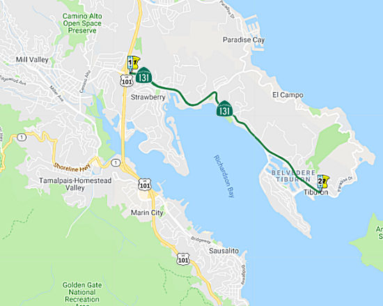 From Route 101 to Tiburon.
 Post 1964 Signage History
This definition remains unchanged from 1963. This is via Tiburon Blvd.
It appears that one rationale for this route may have been to support an
additional bay crossing. Marin County representatives had been working for
a second crossing to San Francisco since the 1940s, and elected
assemblycritters from the area supported the cause in 1950. In 1955, the
legislature appropriated $50,000 for a formal engineering study of a
bridge via Angel Island; and in 1956, the design and location of a span
crossing Angel Island and landing on the Tiburon peninsula won federal
approval. However, most Tiburon homeowners, including influential Marin
Conservation League president and wealthy philanthropist Caroline
Livermore, supported a plan to make Angel Island a state park. Arguing
that a bridge landing would ruin the island’s potential for
recreational use, they convinced state Department of Parks and Recreation
officials to oppose it. Citizens from both sides of the bay staged
protests, organized committees, and formed action groups, succeeding in
delaying state construction plans. It is likely that the crossing fed into
future planning for Route 131, it it was the likely N terminus of such a
crossing.
(Source: "REVOLT AGAINST SPRAWL: Transportation and the Origins of the Marin County Growth-Control Regime" (paywall), Louise Nelson Dyble, University of Southern California, Journal of Urban History, Vol. 34 No. 1,
November 2007, via Anneliese Agren, 11/15/2023)
 Pre 1964 Signage History
This route was LRN 52, defined in 1919. It was not a signed route before 1964.
Sign Route 131 was not defined as part of the initial state signage of routes in 1934. It is unclear what (if any) route was signed as Sign Route 131 between 1934 and 1964.
 Status
In October 2023, it was reported that plans are in the works to repair
and upgrade about 4.6 miles of Tiburon Boulevard. The project, estimated
to cost around $23 million, would take about a year and be completed in
three segments — the western, central and eastern parts —
beginning in spring of 2026. The plan calls for upgrading or replacing
guardrails, road signs, and drainage and electrical systems. It also
includes upgrading curbside ramps to be compliant with the Americans with
Disabilities Act, repaving roads and the addition of bike lanes. The
western segment of the project, spanning from Tower Drive in Mill Valley
to Reed Ranch Road in Tiburon, includes changes to two intersections. At
East Strawberry Drive, the right turn lane onto eastbound Tiburon
Boulevard would be removed and the existing bus stop on Tiburon Boulevard
would be relocated. The new bus stop would be coordinated with transit
authorities during the final design phase in the summer of 2025. Class IV
bikeways would be added along Tiburon Boulevard, from approximately 1,000
feet west of the freeway to Trestle Glen Boulevard. A class I bikeway at
East Strawberry Drive to Greenwood Cove Drive is also planned. The central
section of the project, spanning from Reed Ranch Road to San Rafael
Avenue, includes adding a class IV bike lane from Reed Ranch Road to
Trestle Glen Boulevard. The Avenida Miraflores/Tiburon Boulevard
intersection would be altered to remove the right turn lane from westbound
Tiburon Boulevard onto northbound Avenida Miraflores. The eastern section,
from San Rafael Avenue to the Tiburon Boulevard/Main Street intersection,
includes a curb extension at the Mar West Street intersection. It also
would add yield lines to the Ned’s Way/Tiburon Boulevard
intersection. After the public comment period ends, Caltrans will either
grant environmental approval, conduct additional environmental studies or
abandon the project. The project also requires approval from agencies such
as the state Department of Fish and Wildlife and the California
Transportation Commission.
(Source: Marin I-J, 10/31/2023)
 Other WWW Links
 Statistics
Overall statistics for Route 131:
 Pre-1964 Legislative Route
In 1933, Chapter 767 defined the route “[LRN 4] near Kingsburg to [LRN 10] near Lemoncove” as a state highway. It was codified in 1935 in the highway code as LRN 131 with the definition:
This is present-day Route 201 between Kingsburg and Elderwood, and Route 216 between Woodlake and Lemon Cove. The Route 245 portion between Elderwood and Woodlake was LRN 129; the LRN 130 routing in the area is unclear.
© 1996-2020 Daniel P. Faigin.
Maintained by: Daniel P. Faigin
<webmaster@cahighways.org>.
 Route 130
 Route 132