
 California Highways:
Click here for a key to the symbols used. An explanation of acronyms may be found at the bottom of the page.
 Routing
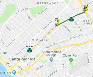 The point where Santa Monica Boulevard crosses the city
limits of Santa Monica at Centinela Avenue to Route 405 in Los Angeles.
The point where Santa Monica Boulevard crosses the city
limits of Santa Monica at Centinela Avenue to Route 405 in Los Angeles.
 Post 1964 Signage History
▸In 1963, this route was defined by Chapter 385 to run from "Route 1 near Santa Monica to Route 138 via the vicinity of Avenue 36 in Los Angeles and via Glendale and Wrightwood."
Note that Route 1 in Santa Monica was originally the intersection of Pennsylvania/Olympic and Lincoln; this was moved to the Santa Monica Freeway (I-10) at Lincoln when the freeway was constructed.
▸In 1965, Chapter 1371 split the route into two segments: (a) Route 1 near Santa Monica to Route 101; (b) Route 101 to Route 138 via the vicinity of Avenue 36 in Los Angeles and via Glendale and Wrightwood.
▸In 1990, Chapter 1187 made the endpoint of this route more specific, changing it to "Route 101 in Los Angeles".
▸In 1998, Chapter 877 changed the starting point to eliminate the route within the City of Santa Monica but changing "Route 1 near Santa Monica" to "The point where Santa Monica Boulevard crosses the city limits of the City of Santa Monica at Centinela Avenue". This change also added text to permit the relinquishment of the portions of Route 2 located within the City of West Hollywood and the City of Santa Monica, effective on the date the agreement is approved. The cities were required the cities to maintain within their jurisdictions signs directing motorists to the continuation of State Highway Route 2. These portions (Doheny Dr to La Brea Avenue in West Hollywood, Route 1 to PM2.32 in Santa Monica) have subsequently been relinquished to the containing cities. Note that TCRP Project #142 will do some additional repair and maintenance on this segment.
▸In 2001, the legislature authorized relinquishment of the portion of Route 2 that is located between I-405 and Moreno Drive to the City of Los Angeles, per SB 290, Chapter 825, 10/13/2001. In June 2002, the CTC had the relinquishment of the segment 07-LA-2-PM 3.9/5.9 in the City of Los Angeles on its agenda. That is likely this segment.
▸In 2003, SB 315, Chapter 594, 9/29/2003, changed the legislative definition to exclude the portions in West Hollywood, Santa Monica, and the city of Los Angeles (between I-405 and Moreno Drive), and to permit relinquishment in Beverly Hills.
▸In 2004, AB 3047, Chapter 650, 9/21/2004, cleaned up the relinquishment language, and added the ability to relinquish the conventional highway portion in the City of Los Angeles. For those not keeping score, once the relinquishments in Beverly Hills and Los Angeles occur, the first segment of this route will mostly be gone. According to the Beverly Hills Weekly in July 2005, the Beverly Hills City Council approved a resolution in late July 2005 that will result in the relinquishment of a the designated portion of Route 2, and a total of $4.3 million to the city for the maintenance and repair of the highway. The Beverly Hills stretch of highway covers 1.8 miles and receives a high volume of traffic. According to Dave Gustavson, Director of Public Works and Transportation for Beverly Hills, the part of the highway west of Wilshire accommodates 35,000 vehicles per day, while east of Wilshire sees 51,000 vehicles per day.
▸In 2010, SB 1318 (9/28/10, Chapter 491) rewrote this as two segments. The pre-2010 definition was:
(a) The point where Santa Monica Boulevard crosses the city limits of Santa Monica at Centinela Avenue to Route 101 in Los Angeles, except the relinquished portions described in subdivision (b). Subdivision (b) defines these portions as the relinquished former portions of Route 2 within the city limits of West Hollywood and Santa Monica, and between Route 405 and Moreno Drive in Los Angeles. Those relinquished portions are not a state highway and are not eligible for re-adoption as a state highway. Those cities shall maintain signs within their respective jurisdictions directing motorists to the continuation of Route 2.
(b) The Transportation Commission is also permitted to relinquish to the City of Beverly Hills the portion of Route 2 that is located between the city's west city limit at Moreno Drive and the city's east city limit at Doheny Drive, upon terms and conditions the commission finds to be in the best interests of the state. The City of Beverly Hills shall maintain within its jurisdiction signs directing motorists to the continuation of Route 2. Additionally, the commission may relinquish to the City of Los Angeles the conventional highway portion of Route 2 that is located within the city limits of Los Angeles, upon terms and conditions the commission finds to be in the best interests of the state, including, but not limited to, a condition that the City of Los Angeles maintain within its jurisdiction signs directing motorists to the continuation of Route 2. This section was up for relinquishment in August 2005.
▸This also added the following clarifying words on relinquishments:
(b) The relinquished former portions of Route 2 within the Cities of West Hollywood, Santa Monica, Beverly Hills, and Los Angeles are not state highways and are not eligible for adoption under Section 81. Those cities shall maintain signs within their respective jurisdictions directing motorists to the continuation of Route 2.
(c) (1) Notwithstanding subdivision (a), the commission may relinquish to the City of Los Angeles the conventional highway portion of Route 2 that is located within the city limits of that city, upon terms and conditions the commission finds to be in the best interests of the state, including, but not limited to, a condition that the City of Los Angeles maintain within its jurisdiction signs directing motorists to the continuation of Route 2. (2) A relinquishment under this subdivision shall become effective immediately following the recording by the county recorder of the relinquishment resolution containing the commission's approval of the terms and conditions of the relinquishment. (3) On and after the effective date of the relinquishment, both of the following shall occur: (A) The portion of Route 2 relinquished under this subdivision shall cease to be a state highway. (B) The portion of Route 2 relinquished under this subdivision may not be considered for future adoption under Section 81. (4) For the portions of Route 2 that are relinquished, the City of Los Angeles shall maintain within its jurisdiction signs directing motorists to the continuation of Route 2.
Beverly Hills Freeway
 1948") Planning for the Beverly Hills Freeway (still called the
Santa Monica Parkway, as it ran along Santa Monica Blvd) shows up in the
1940s. The Street Traffic Management Plan for Los Angeles from 1948 shows the Santa Monica Parkway running from the Ocean Parkway (essentially, Route 1)
through Beverly Hills to a junction with the Hollywood Parkway and the
Allesandro Parkway (in orange in the image to the right, future Glendale
Freeway), and then continuing parallel to the Harbor Parkway. Although
that latter parallel segment would go away, the basic routing for the
Santa Monica Parkway was an early planning variation for the future
Beverly Hills Freeway proposal.
Planning for the Beverly Hills Freeway (still called the
Santa Monica Parkway, as it ran along Santa Monica Blvd) shows up in the
1940s. The Street Traffic Management Plan for Los Angeles from 1948 shows the Santa Monica Parkway running from the Ocean Parkway (essentially, Route 1)
through Beverly Hills to a junction with the Hollywood Parkway and the
Allesandro Parkway (in orange in the image to the right, future Glendale
Freeway), and then continuing parallel to the Harbor Parkway. Although
that latter parallel segment would go away, the basic routing for the
Santa Monica Parkway was an early planning variation for the future
Beverly Hills Freeway proposal.
(Source: LA Metro Primary Resources, "Past Visions of Los Angeles’ Transportation Future: 1940s", retrieved 12/23/2023)
 The first mention of the Beverly Hills Freeway was in a
1961 issue of CHPW, where it noted that studies were in progress for the
Beverly Hills Freeway between the San Diego Freeway near Westwood and the
Hollywood Freeway. Extensive research was being conducted for this project
in land-value study zones in order to provide comparable estimates of
right of way needs for alternate possible alignments. It is anticipated
that the studies will be completed preparatory to a public meeting
sometime in 1962. An article in the Los Angeles Times on 12/17/1961 showed
the connection between the Glendale Freeway and the Beverly Hills Freeway.
The first mention of the Beverly Hills Freeway was in a
1961 issue of CHPW, where it noted that studies were in progress for the
Beverly Hills Freeway between the San Diego Freeway near Westwood and the
Hollywood Freeway. Extensive research was being conducted for this project
in land-value study zones in order to provide comparable estimates of
right of way needs for alternate possible alignments. It is anticipated
that the studies will be completed preparatory to a public meeting
sometime in 1962. An article in the Los Angeles Times on 12/17/1961 showed
the connection between the Glendale Freeway and the Beverly Hills Freeway.
(Source: Los Angeles Times, 12/17/1961 via Joel
Windmiller, 1/18/2023, and other sources)
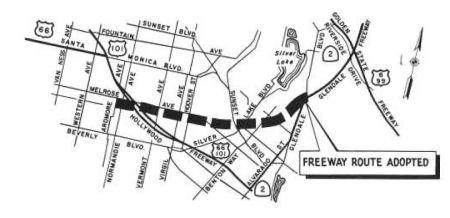
 According to a September 1965
CalTrans planning map, this was to be freeway from I-405 to US 101. In
late 1965, the CHC adopted a route for the Route 2 freeway from the San
Diego Freeway to Adrmore. However, this was never constructed; the
constructed freeway starts just before I-5 (and continues to I-210 as the
Glendale Freeway). They could never get permission to build through
Beverly Hills (for the longest time, there were discussions about having
the freeway go underground through Beverly Hills). Of all the freeways in
the Southern California area that were never built, the Beverly Hills
Freeway (Route 2) probably would have had the greatest impact on both
traffic volume and the surrounding neighborhoods (not all of it for the
better). The image to the right is from a 1966 Thomas Brothers map showing
the interchange with US 101.
According to a September 1965
CalTrans planning map, this was to be freeway from I-405 to US 101. In
late 1965, the CHC adopted a route for the Route 2 freeway from the San
Diego Freeway to Adrmore. However, this was never constructed; the
constructed freeway starts just before I-5 (and continues to I-210 as the
Glendale Freeway). They could never get permission to build through
Beverly Hills (for the longest time, there were discussions about having
the freeway go underground through Beverly Hills). Of all the freeways in
the Southern California area that were never built, the Beverly Hills
Freeway (Route 2) probably would have had the greatest impact on both
traffic volume and the surrounding neighborhoods (not all of it for the
better). The image to the right is from a 1966 Thomas Brothers map showing
the interchange with US 101.
Evidently, around 1960, there were two planned freeway corridors for the segments W of US 101:
 In March/April 1963, it was
noted that the route for the connecting link of the Glendale Freeway
between the Hollywood Freeway at Vermont Avenue and the southerly end of
the constructed Glendale Freeway was adopted by the CHC on 1/23/1963.
Included in this portion of the 8-lane freeway is an interchange with the
Hollywood Freeway that would require extensive revision of the existing
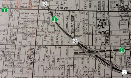
Hollywood Freeway from Virgil to Normandie. A 1966 Thomas Brothers map
shows the adopted routing, with interchanges at Glendale/Allesandro,
Sunset/Silverlake, and US 101. Continuing from the current terminus at
Glendale, it would have paralleled Waterloo and tangentially touched
McCallum near Mayberry and Berkeley (the map shows streets closed that are
open today), with bridges at Berkeley and Benton Way (it appears there was
subsequent infill development), to the interchange with Sunset just N of
the Silverlake bridge. If you look at today's map, run just E of McCollum,
between Apex and Effie, go between McCollum St and Coronado, veer W after
the bridge at Berkeley, to another bridge at Benton and Scott (start of
the Sunset interchange). The route then continued W about 1/2 S of Melrose
to meet US 101 at Melrose/Vermont. Bridges at Michaeltorena, Hoover,
Virgil and Vermont.
In March/April 1963, it was
noted that the route for the connecting link of the Glendale Freeway
between the Hollywood Freeway at Vermont Avenue and the southerly end of
the constructed Glendale Freeway was adopted by the CHC on 1/23/1963.
Included in this portion of the 8-lane freeway is an interchange with the
Hollywood Freeway that would require extensive revision of the existing
Hollywood Freeway from Virgil to Normandie. A 1966 Thomas Brothers map
shows the adopted routing, with interchanges at Glendale/Allesandro,
Sunset/Silverlake, and US 101. Continuing from the current terminus at
Glendale, it would have paralleled Waterloo and tangentially touched
McCallum near Mayberry and Berkeley (the map shows streets closed that are
open today), with bridges at Berkeley and Benton Way (it appears there was
subsequent infill development), to the interchange with Sunset just N of
the Silverlake bridge. If you look at today's map, run just E of McCollum,
between Apex and Effie, go between McCollum St and Coronado, veer W after
the bridge at Berkeley, to another bridge at Benton and Scott (start of
the Sunset interchange). The route then continued W about 1/2 S of Melrose
to meet US 101 at Melrose/Vermont. Bridges at Michaeltorena, Hoover,
Virgil and Vermont.
 Freeway adoption hearings were planned for
1964, and the Beverly Hills City Council adopted policy in November 1963.
The policy states that “such project must not take any single family
residences in Beverly Hills nor remove, destroy or reduce any of its
parks, nor interfere with its churches or schools.” It expresses
that “such freeway must be depressed at least twenty feet below the
surface throughout Beverly Hills. These restrictions laid the foundation
for the April, 1964 Report On Geometric Design: Proposed Beverly Hills Freeway For Beverly Hills City Council. This policy pushed for the Santa Monica Blvd route.
Freeway adoption hearings were planned for
1964, and the Beverly Hills City Council adopted policy in November 1963.
The policy states that “such project must not take any single family
residences in Beverly Hills nor remove, destroy or reduce any of its
parks, nor interfere with its churches or schools.” It expresses
that “such freeway must be depressed at least twenty feet below the
surface throughout Beverly Hills. These restrictions laid the foundation
for the April, 1964 Report On Geometric Design: Proposed Beverly Hills Freeway For Beverly Hills City Council. This policy pushed for the Santa Monica Blvd route.
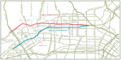
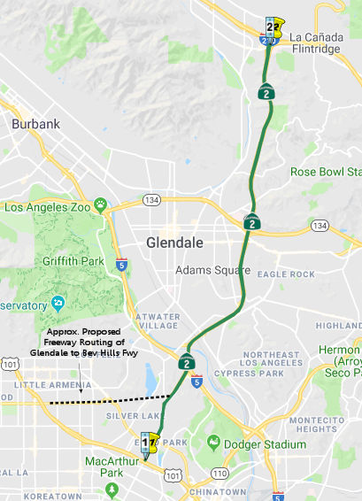
A 1975 Thomas Brothers map essentially shows the Blue Corridor as the accepted corridor between US 101 and the Beverly Hills City limits. The route runs westerly S of Melrose to the edge of Evergreen Cemetery/Paramount Studios 2 bl E of Rossmore, where it turns diagonally NW to between Willoghby and Waring, 2 bl S of Santa Monica Blvd. It continues Westerly in a straight line until intersecting Santa Monica Blvd (Route 2) in West Hollywood near Hancock Ave. No proposed freeway is shown west of that point, nor does the Thomas Brothers Guide show any intersections for that portion.
According to an article in the Beverly Hills Weekly, the very plans for a proposed freeway to serve Beverly Hills were the original plans for the Santa Monica Freeway. The route selected by the publisher of the Santa Monica Outlook and chair of the state's Highway Commission was near Pico Boulevard. However, this was opposed by the major business interests of the Beverly Hills; the rationale was that with a Santa Monica freeway running near the southern borders of the city, customers for Beverly Hills stores could more easily reach both the downtown Los Angeles and Santa Monica shopping districts, and the freeway could make the development of competing office buildings on the booming Westside more accessible. As a result of these protests, the route was changed to the current routing. In the 1960s, the Beverly Hills City Council offered strong support for a freeway between the two Santa Monica Boulevards that would connect to the Hollywood Freeway on the east, and north and be a second link to the beach. However, this was too close to the pricy real estate just N of Santa Monica Blvd. It was also seen as a permanent divider between the north and south areas of the city. To resolve the issue, the Department of Highways proposed a "cut and cover" freeway. In fact, a geometric design study indicated that a fully depressed and concealed freeway was feasible. The problem was the cost of such construction, which was four times normal costs. The City Council could also not ensure it would be below ground. So, even though the route was on the books, the state could not give assurances of below-ground construction. The political realities were not lost on Anthony Beilenson, who made sure the Beverly Hills Freeway died a quiet demise in the assembly. The freeway was officially cancelled in 1975.
The geometric report indicated that it would be virtually impossible to provide the additional street capacity required through surface street improvements (something that has come to pass). Additional details, including the specifics of the depressed routing, the rationale, illustrations of construction and routing, and costs figures, may be found in the geometric report.
In 1964, it was reported that there were public hearings regarding the Beverly Hills Freeway (Route 2), from the San Diego Freeway to Ardmore Avenue, near the Hollywood Freeway.
 In 1975, the CHC published a notice that it was considering rescission of a 9.5 mi
segment of the adopted freeway corridor between I-405 and US 101. The
corridor was adopted in 1965. The stated reason was "lack of funds".
In 1975, the CHC published a notice that it was considering rescission of a 9.5 mi
segment of the adopted freeway corridor between I-405 and US 101. The
corridor was adopted in 1965. The stated reason was "lack of funds".
(Source: Los Angeles Times, 03 Oct 1975, via Joel Windmiller,
2/25/2023)
 Pre 1964 Signage History
Note that before this was added to the state highway system, Santa Monica and the ACSC signed the route as US 66 briefly in 1931 (without the permission of AASHO). That signage was removed by April 1931, when the end of US 66 was signed at Fletcher and San Fernando Road.
This segment was added to the state highway system in 1933 as LRN 162. It originally ran along Lincoln Blvd from US 101A (Sign Route 3) at Pennsylvania (later Olympic) to Santa Monica Blvd, along Santa Monica Blvd from Lincoln in Santa Monica to Myra Avenue (near Sunset), then North along Myra Avenue to Fountain, across Fountain to Hyperion Ave, up to Rowena. It then ran across Rowena (now Glendale Blvd) to the intersection of Glendale and Fletcher, and then up Fletcher (crossing San Fernando) to meet LRN 61 at Verdugo Road (note that some of this has been subsequently rerouted due to the Glendale Freeway). At this point, LRN 162 continued along Eagle Rock Blvd to end at LRN 161 at Colorado. It is unclear if the portion along Eagle Rock Blvd was signed as Sign Route 2. Sign Route 2 clearly continued along LRN 61, which ran N from San Fernando Road along Verdugo, then along Cañada Blvd, then N along Verdugo Road to Foothill Blvd (Sign Route 118).
The signage of this is convoluted:
Given that Myra was an underpass under Sunset Blvd (US 101, at the time), there was likely a connection between the roads. From NB/EB Santa Monica, traffic for EB Sunset likely continued on Santa Monica to Sunset (as there was a PE line along the route); or for WB Sunset, went up Hoover. Traffic on Sunset WB for SB/WB Santa Monica likely had a left onto Santa Monica (or traffic might have been routed down Hoover); for NB/EB Sign Route 2, traffic likely made a right onto Hyperion. From EB Sunset, traffic for SB/WB Santa Monica likely went down Hoover; SN/EB Route 2 traffic continued on Fountain. There is no evidence that these connector roads were under state maintenance or were formally part of the state system; they were artifacts of the Myra underpass (and were likely constructed before the state had any authority over highways within city limits).
In 1934, LRN 162 (Santa Monica to Ave 36), LRN 61 (Ave 36 to Sign Route 138), and LRN 188 (Sign Route 138 to Sign Route 18) were signed as Sign Route 2 in the initial state routing in 1934 (Santa Monica via Santa Monica Blvd to Jct. Route 18 at Lake Arrowhead, via Arroyo Seco and Cajon). In 1935, US 66 was extended from Sunset Blvd to run to Santa Monica along Santa Monica Blvd. Sign Route 2 from Sunset to Santa Monica was then co-signed/re-signed as US 66, and remained with that signage until 1964. The segment of LRN 162 N of Myra was to be US 66 but that was never approved and thus the segment remained Sign Route 2; the segment of LRN 162 between Avenue 36/Fletcher and Colorado, along Eagle Rock Blvd, was also originally planned to be signed as part of US 66, but that was never approved. It is likely that segment was not signed.A 1954 issue of CHPW confirms that the widening of US 101 near Vermont was in anticipation for the future Route 2 freeway (LRN 162, called, at that time, the "Santa Monica Freeway" as it ran along Santa Monica Blvd, vice LRN 173, the Olympic Freeway (Route 26), which eventually became I-10): "The design finally adopted for the Hollywood Freeway at the crossing. with Vermont Avenue was influenced by the contemplated future construction of the Santa Monica Freeway and also the possibility of rail rapid transit facilities being installed on the future Santa Monica Freeway. This required the lengthening of the Vermont Avenue Bridge and other bridges in the vicinity. The added cost providing for future rail rapid transit facilities was financed by the City of Los Angeles from city funds. Similarly financed from city funds were the bus transfer facilities at Alvarado Street and Vermont Avenue and Western Avenue."
 Status
Santa Monica Blvd Complete Streets Improvements (07-LA-2 2.3/14.2)
The following project was included in the final adopted 2018 SHOPP in March 2018: PPNO 5184. 07-Los Angeles-2 2.3/14.2. On Route 2 (Santa Monica Blvd) In and near the city of Los Angeles, from Centinela Avenue to Cotner Avenue, North La Brea Avenue to North Oxford Avenue and N. Hollywood Boulevard to Allesandro Street. Cold plane and overlay pavement, upgrade curb ramps, reconstruct curb and gutter, construct bus pads and replace traffic signals at several locations. Begin Con: 12/1/2022. Total Project Cost: $31,908K.
In September 2021, it was reported that Caltrans was
planning a complete streets project along Alvarado Street and Santa Monica
Boulevard. Caltrans plans to add a Bus Only/Bike Lane (apparently the
northern portion of the partially opened Alvarado bus lane), pedestrian
beacons, striping, markings, and a new signal. Estimated cost is
$2,370,000. The project is divided into three separate segments –
entirely in the city of Los Angeles, as follows:
(Source: Streetsblog LA, 9/22/2021)
In August 2022, the CTC approved the following
construction phase allocation: $31,050,000. 07-LA-2 2.3/14.2. PPNO
07-5184; ProjID 0716000313; EA 33360. Route 2 In and near the city of Los
Angeles, from Centinela Avenue to Cotner Avenue, North La Brea Avenue to
North Oxford Avenue and North Hollywood Boulevard to Allesandro Street.
Outcome/Output: Grind and overlay pavement, upgrade curb ramps,
reconstruct curb and gutter, construct bus pads and bicycle and
intersection improvements as complete streets elements and relocate nine
signal poles. This project will extend and preserve pavement and improve
ride quality and safety. Programmed allocation: CON ENG $4,453,000 CONST
$21,698,000. CEQA - CE, 10/31/2016; Re-validation 6/17/2022. NEPA - CE,
10/31/2016; Re-validation 6/17/2022. As part of this allocation request,
the Department is requesting to extend the completion of CONST and CON ENG
an additional 15 months beyond the 36 month deadline. SB 1 Baseline
Agreement approval under Resolution SHOPP-P-2021-07B; June 2021. Two month
time extension for CONST and CON ENG approved under Waiver 22-73; June
2022. Concurrent Amendment under SHOPP Amendment 22H-003; August 2022. The
Department is requesting to extend the completion of contract award an
additional 6 months beyond the 6-month deadline.
(Source: August 2022 CTC Agenda, Agenda Item
2.5b.(1) #43)
In January 2024, the CTC approved the following
construction-phase SHOPP allocation: $53,091,000. 07-LA-2 2.321/14.2. PPNO
07-5184; ProjID 0716000313; EA 33360. Route 2 In and near the city of Los
Angeles, from Centinela Avenue to Cotner Avenue, North La Brea Avenue to
North Oxford Avenue and Route 101 to Glendale Boulevard
Undercrossing. Outcome/Output: Rehabilitate pavement, construct
bus pads, make bicycle and intersection improvements, modify traffic
signals, upgrade curb and gutters and lighting, and upgrade
facilities to Americans with Disabilities Act (ADA) standards. (Additional
Contribution: $825,000 CONST in Measure M funds from City of Los Angeles.)
CEQA - CE, 10/31/2016; Re-validation 11/13/2023. NEPA - CE, 10/31/2016;
Re-validation 11/13/2023. As part of this allocation request, the
Department is requesting to extend the completion of CONST and CON ENG an
additional 27 months beyond the 36 month deadline. SB 1 Baseline Agreement
approval under Resolution SHOPP-P-2021-07B; June 2021. Pre-Construction
Phase: Budgeted (Actual, if different): PA&ED
$533,000 ($302,739); PS&E $1,484,000 ($1,037,299);
R/W Sup $14,000 ($9,401). Construction Phase -
Programmed ($ × 1000) (Allocation, if different):
CON ENG $5,500,000; CONST $47,700,000 ($42,132,000).
(Source: January 2024 CTC Agenda, Agenda Item 2.5b.(1) #14)
 Naming
The proposed name for the freeway segment between Route 1 and the current Glendale Freeway was the "Beverly Hills Freeway". This is because the original freeway routing would have traversed the city of Beverly Hills. Beverly Hills was named in 1907 by B.E. Green after Beverly Farms, Massachusetts.
 Historical Route
This segment is part of "Historic Highway Route 66", designated by Assembly Concurrent Resolution 6, Chapter 52, in 1991.
 National Trails
 This segment was part of the "Arrowhead Trail (Ocean to Ocean Trail)". It was named by Resolution Chapter 369 in 1925.
 This segment was part of the "National Old Trails Road".
 This segment was part of the "New Santa Fe Trail".

 This segment appears to have been part of the "National Park to Park Highway", and the "Pikes Peak Ocean to Ocean Highway".
 Other WWW Links
 Freeway
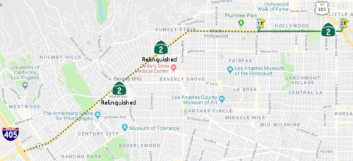 The point where Santa Monica Boulevard crosses the city limits of West
Hollywood into the City of Los Angeles at La Brea Avenue to Route 101 in
Los Angeles.
The point where Santa Monica Boulevard crosses the city limits of West
Hollywood into the City of Los Angeles at La Brea Avenue to Route 101 in
Los Angeles.
Post 1964 Signage HistoryThis segment was created in 2010 by SB 1318. See the first segment for the pre-2010 history.
StatusIn September 2021, it was reported that Caltrans was planning a complete
streets project along Alvarado Street and Santa Monica Boulevard. Caltrans
plans to add a Bus Only/Bike Lane (apparently the northern portion of the
partially opened Alvarado bus lane), pedestrian beacons, striping,
markings, and a new signal. Estimated cost is $2,370,000. The project is
divided into three separate segments – entirely in the city of Los
Angeles, as follows:
(Source: Streetsblog LA, 9/22/2021)
 From Route 101 in Los Angeles to Route 210 in La Cañada Flintridge via
Glendale.
From Route 101 in Los Angeles to Route 210 in La Cañada Flintridge via
Glendale.
Post 1964 Signage HistoryIn 1963, this route was defined by Chapter 385 to run from "Route 1 near Santa Monica to Route 138 via the vicinity of Avenue 36 in Los Angeles and via Glendale and Wrightwood."
On January 23, 1964, a route adoption occured on a 2.7-mile section of the Glendale Freeway. from Ardmore Avenue to Glendale Boulevard, estimated to cost $27.5 million.
In 1965, Chapter 1371 split the route into two segments: (a) Route 1 near Santa Monica to Route 101; (b) Route 101 to Route 138 via the vicinity of Avenue 36 in Los Angeles and via Glendale and Wrightwood. This change created this segment.
In 1984, Chapter 409 permitted for variation in the route, changing the segment to "Route 101 to Route 138 via Glendale and Wrightwood."
In 1990, Chapter 1187 further split the segment into (b) Route 101 in Los Angeles to Route 210 in La Cañada Flintridge via Glendale and (c) Route 210 in La Cañada Flintridge to Route 138 via Wrightwood.
In 2009, commercial vehicles with three or more axles, or weighing more than 9,000 pounds were banned from Route 2 between the city of La Cañada Flintridge and County Route N2 in Los Angeles County. There is a fine of at least $1,000 for drivers caught with rigs over the weight limit.
In November 2015, Curbed LA reported on a proposal by the
Libertarian-leaning Reason Foundation to construct a downtown bypass
tunnel from the terminus of Route 2 to Route 110 near Exposition Blvd.
They projected that this toll tunnel would carry six
lanes of underground traffic for a throughput of 151,000 cars per day, at
a toll of $1.00 a mile. Over 40 years, the tunnel would bring in about
$13.6 billion. CurbedLA noted, regarding this proposal, "They're cute
plans, but only a fool would run this bureaucratic marathon for a transit
plan that looks backwards to cars instead of forwards to mass transit and
fossil-fuel-free options." The estimated cost for all their tunnels would
be $700 billion.
(Sources: CurbedLA, 11/17/2015; AARoads Forum, Subject; "What about a tunnel from the end of Glendale Freeway
to Interstate 110?")
Pre 1964 Signage HistoryNote that before this was added to the state highway system, Santa Monica and the ACSC signed the route as US 66 briefly in 1931 (without the permission of AASHO). That signage was removed by April 1931, when the end of US 66 was signed at Fletcher and San Fernando Road.
The portion of this segment between Avenue 36 (Fletcher Drive) in Glendale and I-210 was defined as part of the state highway system in 1933 as LRN 61; the portion from US 101 (Sunset Blvd, at the time) to Avenue 36 was defined in the same year, but was part of LRN 162. LRN 61 ran N from San Fernando Road along Verdugo, then along Cañada Blvd, then N along Verdugo Road to Foothill Blvd (LRN 9, Sign Route 118).
In 1933 the definition of LRN 61 was extended east to LRN 59 and west
from LRN 9 (future Route 118) to LRN 4 (future rerouting of US 99). In
1933, the State Legislature made it clear the Division of Highways could
maintain roadways within cites which led to a large swath of highway
adoptions. The route of LRN 61 from LRN 9 south to LRN 4 followed; Verdugo
Boulevard, Cañada Boulevard, and Verdugo Road (at the time all three
were Verdugo Road) through La Cañada Flintridge and Glendale to
Fletcher Drive in Los Angeles. LRN 61 utilized Fletcher Drive to reach LRN 4 on San Fernando Road. South of San Fernando Road Fletcher Road became
LRN 162.
(Source: Gribblenation Blog: "California State Route 2 on the Glendale Freeway")
In 1934, it was signed as Sign Route 2 in the initial state routing in 1934 (Santa Monica via Santa Monica Blvd to Jct. Route 18 at Lake Arrowhead, via Arroyo Seco and Cajon). The segment between Sign Route 138 and Sign Route 18 was LRN 188, added in 1933.
The Glendale Freeway is first mentioned in the January/February 1956
California Highways and Public Works Guide. The first phase of the
Glendale Freeway is cited as a 2.6 mile segment connecting from Avenue 36
(near Eagle Rock Boulevard) south over the Los Angeles River to Glendale
Boulevard. The early Glendale Freeway is cited as being approved by the
State Highway Commission on December 14th, 1955 and was to be planned for
construction during the 1956-57 Fiscal Years. A District 7 report in the
same CHPW issue states that a 1.0 mile section of the Glendale Freeway was
under construction in January 1958. The 1959 Division of Highways State
Map City Insert shows Route 2 on a new freeway route over the Los Angeles
River which replaced much of Fletcher Drive.
(Source: Gribblenation Blog: "California State Route 2 on the Glendale Freeway")
It appears as if this portion was the first portion of the Sign Route 2 freeway constructed, as the "Assesandro Freeway". The primary purpose was to eliminate the grade crossings with the railroad tracks. The original construction contract covered the SP crossing near San Fernando Road and for the l.2 miles lying easterly of Fletcher Drive between the Los Angeles River and Avenue 36 near Eagle Rock Blvd.
The completion of the Glendale Freeway/Golden State Freeway interchange
resulted in an alignment shift of Route 2/LRN 162 onto Glendale Boulevard
and Alvarado Street to reach US 101/US 66 on the Hollywood Freeway.
Previously Route 2/LRN 162 reached US 101/US 66 via Rowena Avenue,
Hyperion Boulevard, Myra Ave, and Santa Monica Boulevard.
(Source: Gribblenation Blog: "California State Route 2 on the Glendale Freeway")
According to Scott Parker on AARoads: Even back in 1953 when it was
constructed, the Hollywood Freeway featured the lane separation near the
Melrose exit that was intended to accommodate LH ramps to and from the
Glendale/Beverly Hills Freeway in a similar fashion to the present
I-5/I-710 interchange in the City of Commerce (itself a holdover from
'50's design standards). The Glendale Freeway was completed to its present
Glendale Blvd. terminus back in 1962; plans were active to extend it to US 101 as late as 1975, but those plans were put on hold when Adriana
Gianturco became Caltrans' chief that year and drastically curtailed
freeway planning and building statewide. Eight years later, when
administrations changed along with agency mission, the Echo Park/Silver
Lake area through which Route 2 would have run had become quite
gentrified, resulting in NIMBY opposition that was echoed within L.A. city
government. At that point the freeway extension was effectively dead. But
the simple truth is that even if that segment connecting to US 101 had
been built, the regional politics had shifted enough that a western
extension through the south part of Hollywood and into Beverly Hills would
be D.O.A. as well. Given the trajectory of the adopted Glendale Freeway
alignment and the configuration of the originally planned US 101/Route 2
interchange, the traffic from Route 2 would have simply segued onto NB US 101 -- which, unless immediately departing the Hollywood Freeway in its
namesake neighborhood, would have been duplicative of other freeway
service (i.e., Route 134). Given all that, the final decision to scrap the
freeway extension was hardly surprising.
(Source: SParker on AARoads, "Re: CA 2/Glendale Freeway", 2/11/2020)
StatusThe first freeway segment opened in 1958; the last segment opened in 1978.
In September 2021, it was reported that Caltrans was planning a complete
streets project along Alvarado Street and Santa Monica Boulevard. Caltrans
plans to add a Bus Only/Bike Lane (apparently the northern portion of the
partially opened Alvarado bus lane), pedestrian beacons, striping,
markings, and a new signal. Estimated cost is $2,370,000. The project is
divided into three separate segments – entirely in the city of Los
Angeles, as follows:
(Source: Streetsblog LA, 9/22/2021)
State Route 2 Terminus Improvement Project
 In January 2011, it was reported that the Los Angeles County Metropolitan Authority, in conjunction with
CalTrans and LA Dot has a project to improve traffic flow where the Route 2 Freeway terminates
at Glendale Blvd. Initially, Metro came up with five different plans
(dubbed alternatives A-F) to address these issues. After gathering
community feedback, Metro adopted Hybrid Alternative F, otherwise known as
the locally preferred alternative. The most radical addition is for a
proposed left-lane off-ramp from Route 2 onto Glendale Boulevard heading
north. Additionally, there will be two dedicated lanes from Route 2 onto
southbound Glendale Boulevard; currently they merge into one lane. Project
funding originated with a $12 million federal transportation grant. None
of the five original designs put forward by Metro come within this budget.
$3 million has already been spent on beginning stages of the project.
Going forward with Alternative F, estimated to cost $18.4 million, leaves
a shortfall of $9.4 million. Even Alternative A, the most basic no-build
plan, was estimated to cost $13.2 million. Open space improvements are
estimated at an additional $5 million, according to Metro's timeline
projects a final construction contract in place by the end of 2011, with
groundbreaking slated for early 2012. Barring any unforeseen delays, and
subject to the acquisition of additional funding, work is expected to be
completed by June of 2013.
In January 2011, it was reported that the Los Angeles County Metropolitan Authority, in conjunction with
CalTrans and LA Dot has a project to improve traffic flow where the Route 2 Freeway terminates
at Glendale Blvd. Initially, Metro came up with five different plans
(dubbed alternatives A-F) to address these issues. After gathering
community feedback, Metro adopted Hybrid Alternative F, otherwise known as
the locally preferred alternative. The most radical addition is for a
proposed left-lane off-ramp from Route 2 onto Glendale Boulevard heading
north. Additionally, there will be two dedicated lanes from Route 2 onto
southbound Glendale Boulevard; currently they merge into one lane. Project
funding originated with a $12 million federal transportation grant. None
of the five original designs put forward by Metro come within this budget.
$3 million has already been spent on beginning stages of the project.
Going forward with Alternative F, estimated to cost $18.4 million, leaves
a shortfall of $9.4 million. Even Alternative A, the most basic no-build
plan, was estimated to cost $13.2 million. Open space improvements are
estimated at an additional $5 million, according to Metro's timeline
projects a final construction contract in place by the end of 2011, with
groundbreaking slated for early 2012. Barring any unforeseen delays, and
subject to the acquisition of additional funding, work is expected to be
completed by June of 2013.
In Winter 2013, Caltrans published an overview of the
Terminus Improvement project. The overview noted that plans to connect the
Route 2 Freeway with the Hollywood Freeway (US 101) were rescinded
following local stakeholder opposition. The resulting halt of construction
led to the present Route 2 terminus location near Glendale Bl and Duane
St. Over the years this area has grown increasingly congested, especially
along Glendale Bl and Alvarado St. As a project to improve safety, the MTA
and Caltrans and the City of LA worked on a number of studies to assess
potential solutions for the Route 2 Terminus area. The most recent
environmental study to 2013 evaluated five alternatives from which a
Hybrid Alternative was developed and subsequently adopted in 2010 as the
preferred alternative. Since that time, the agencies have worked with
local legislative offices to identify and secure funding to upgrade the
immediate area surrounding the terminus at the Route 2 and Glendale Bl. As
of Winter 2013, Caltrans was developing the final designs for the Hybrid
Alternative, which has been divided into three phases for funding and
construction purposes. There were three planned phases:
(Source: SR-2 Terminus Improvement Project Newsletter, Winter 2013, via Wayback Machine)
It appears that Phase 1B and Phase 2 were shelved.
(Source: Biking In LA, 2/7/2022)
In July 2016, the LA Times revealed a reimagining of the southern end of the Glendale Freeway. In this reimagining, from Chris Reed, a landscape architect and associate
professor at Harvard’s Graduate School of Design, and his firm,
Stoss Landscape Urbanism, that part of the freeway is turned into an
elevated park in shades of orange and fuchsia. Closing the spur to traffic
but preserving the elevated structure itself, the park would be dotted
with towers designed to clean the air and capture solar energy and storm
water. Some of that water would be used to irrigate new planted areas; on
very hot days, huge cooling towers would be switched on to convert a
modest amount of water to mist. Giant shade structures would be wrapped in
a photovoltaic skin, generating enough power to operate smog filters
designed to suck in and clean polluted air. The surface of the old freeway
(the “State Route 2 Terminus,” to use the official Caltrans
language) would be covered with carbon-absorbing paving capable of
trapping pollutants from the air while allowing storm water to pass
through and flow to ground-level retention ponds. The area beneath the
structure would also be opened to the public, holding both an adventure
park in the shadow of the old freeway and walking and bike paths leading
to nearby Elysian Park and the Los Angeles River. There is also an easy
possible connection from the remade spur to the 10-acre Corralitas Red Car
property, which may soon become a park thanks to efforts by local
activists and the Trust for Public Land. As for the cars that now use this
section of the freeway, which is essentially a very long off-ramp, Reed
suggests rerouting some of them from the I-5 interchange along Alessandro
Street, which runs roughly parallel to the freeway spur’s eastern
edge and in his proposal is remade as a formal boulevard. Cars continuing
south would then make their way to Glendale Boulevard, which sits at the
base of the freeway spur and has long absorbed the brunt of its traffic.
(Source: Los Angeles Times, 6/29/2016)
NamingThe segment of Route 2 from U 101 to Route 210 is named the "Glendale Freeway". This is because this segment goes through the City of Glendale. It was named by the State Highway Commission on August 17, 1955.
From historical usage, this has also been named the "Allesandro Freeway" (the portion parallel to Allesandro Street). Allesandro was a character in the Helen Hunt Jackson novel Ramona, which was a seminal novel in the early 20th century in creating the romance of California.
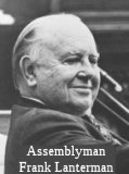 The segment between Route 134 and Route 210 is also named the "Frank
Lanterman Freeway". Frank Lanterman was an Assemblyman from the La
Cañada Flintridge region for 28 years. He was the leading
spokesperson for Republicans on all social welfare issues and health
issues. He was a member of one of the founding families of the La
Cañada Flintridge community, and was responsible for obtaining
Colorado River water for La Cañada in 1955. In 1969, he authored the
Lanterman Mental Retardation Services Act, which established a statewide
system of regional centers. In 1974, he sponsored additional legislation
that expanded the clientele served by the regional centers to include
persons with cerebral palsy, epilepsy, autism, and other significantly
handicapping conditions found to be closely related to mental retardation.
He was the author of HB 3896, which prohibited the expenditure of Rapid
Transit District funds from the ½¢ sales tax for purposes other
than planning and design, such as capital development, unless approved by
the affected local jurisdictions. The highway was named by Assembly
Concurrent Resolution No. 131, Chapter 126, in 1978.
The segment between Route 134 and Route 210 is also named the "Frank
Lanterman Freeway". Frank Lanterman was an Assemblyman from the La
Cañada Flintridge region for 28 years. He was the leading
spokesperson for Republicans on all social welfare issues and health
issues. He was a member of one of the founding families of the La
Cañada Flintridge community, and was responsible for obtaining
Colorado River water for La Cañada in 1955. In 1969, he authored the
Lanterman Mental Retardation Services Act, which established a statewide
system of regional centers. In 1974, he sponsored additional legislation
that expanded the clientele served by the regional centers to include
persons with cerebral palsy, epilepsy, autism, and other significantly
handicapping conditions found to be closely related to mental retardation.
He was the author of HB 3896, which prohibited the expenditure of Rapid
Transit District funds from the ½¢ sales tax for purposes other
than planning and design, such as capital development, unless approved by
the affected local jurisdictions. The highway was named by Assembly
Concurrent Resolution No. 131, Chapter 126, in 1978.
(Image Source: Frank D. Lanterman Regional Center)
 Double Fine Zones
Between the city limits of La Cañada Flintridge and the intersection with Route 39. Authorized by Senate Bill 1526, Chapter 446, September 14, 2000.
Freeway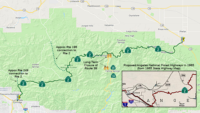 Route 210 in La Cañada Flintridge to Route 138 via Wrightwood.
Post 1964 Signage HistoryThis segment was created in 1990 by Chapter 1187, which split it off of the former (b) segment. Planned as freeway in 1965, but never upgraded, through the Angeles National Forest.
Pre 1964 Signage HistoryThe portion of this segment between I-210 and the Red Box Divide was part of the original 1919 third-bond act definition of LRN 61. In 1931, LRN 61 was extended to reach Route 39. In 1933, it was further extended to reach Route 138.
Before the days of the freeway, this ran N along Haskell St from Foothill Blvd (signed as Route 118, but LRN 9) to the Angeles Crest Highway, and thence over the mountains (as construction allowed). It has been signed as Route 2 since the start of state signage in 1934. Angeles Crest Highway began construction in 1929 after ten years of planning, it made it to Red Box in 1934. A year later, in 1935, the road from Red Box to Mt. Wilson was paved and ready for use.
Additionally, the route continued beyond the junction with Route 138, continuing along current Route 138 to US 91 (present I-15). This former portion was cosigned as Route 138 and Route 2, and was part of the 1931 extension of LRN 59.
From US 91, the route, signed as Route 2, continued along the current Route 138 routing to Route 18. This portion was LRN 59 up to the current Route 138/(unsigned) Route 173 junction at the N end of the Cedar Springs Reservoir, and LRN 188 S to Route 18 (LRN 43). Note that Sign Route 2 ran along the current Route 173 routing (LRN 59) until 1958, when it was transferred to the LRN 188 routing. The LRN 59 portion was added to the state highway system in 1933; the LRN 188 portion was defined as part of the state highway system in 1933.
In 1934, all of these portions were signed as Route 2 in the initial state routing in 1934 (Santa Monica via Santa Monica Blvd to Jct. Route 18 at Lake Arrowhead, via Arroyo Seco and Cajon).
The Angeles Crest Highway (the portion from Route 210 to Route 138) is 66 miles long from I-210 to Route 138. The highway was originally envisioned in 1912 as "the most scenic and picturesque mountain road in the state", but the need for a road for fire-fighting was at least equally important. Funds were allocated beginning in 1919, construction began in 1929, continuing piece by piece until 1956, except from 1941 to 1946 during WWII. The road is typically closed to car traffic and unplowed between Islip Saddle and Big Pines after the first snowfall (typically October through December) until May or June. Its grade never exceeds 6.5 percent. Few of its curves turn a radius tighter than 300 feet. Within five minutes, it achieves commanding views of Los Angeles. Within 30, pine flats. The road was opened on November 8, 1956.
 Construction of the highway began in 1929 and continued
for 27 years under the direction of the California Department of Highways
(now Caltrans) and the U.S. Bureau of Public Roads (now the Federal
Highway Administration). During the Depression, homeless men performed
much of the back-breaking work. Later, convicts from San Quentin and Chino
took up the shovels and pickaxes and were even permitted to handle
dynamite. Engineer J. B. Lippincott, who surveyed the highway for the
Automobile Club of Southern California in 1919 (and who had previously
surveyed the Los Angeles Aqueduct for William Mulholland), routed it high
above the narrow, winding canyons below. It hews to mountain slopes and
surmounts ridge crests. Where nature failed to provide a way, workers
created one, blasting roadcuts into granite and erecting bridges over
drainages. Some cuts are as deep as 240 feet. In the high country near
Islip Saddle, the highway tunnels twice through the mountainside. It
achieves its highest elevation, 7,901 feet, at Dawson Saddle. There are
two highway tunnels, measuring 680 and 470 feet in length. The Angeles
Crest Highway, seen in the 1934 map to the right, was meant to connect
with the San Gabriel Canyon Road to create a scenic loop. The loop was
eventually completed but was severed by a landslide in 1978.
Construction of the highway began in 1929 and continued
for 27 years under the direction of the California Department of Highways
(now Caltrans) and the U.S. Bureau of Public Roads (now the Federal
Highway Administration). During the Depression, homeless men performed
much of the back-breaking work. Later, convicts from San Quentin and Chino
took up the shovels and pickaxes and were even permitted to handle
dynamite. Engineer J. B. Lippincott, who surveyed the highway for the
Automobile Club of Southern California in 1919 (and who had previously
surveyed the Los Angeles Aqueduct for William Mulholland), routed it high
above the narrow, winding canyons below. It hews to mountain slopes and
surmounts ridge crests. Where nature failed to provide a way, workers
created one, blasting roadcuts into granite and erecting bridges over
drainages. Some cuts are as deep as 240 feet. In the high country near
Islip Saddle, the highway tunnels twice through the mountainside. It
achieves its highest elevation, 7,901 feet, at Dawson Saddle. There are
two highway tunnels, measuring 680 and 470 feet in length. The Angeles
Crest Highway, seen in the 1934 map to the right, was meant to connect
with the San Gabriel Canyon Road to create a scenic loop. The loop was
eventually completed but was severed by a landslide in 1978.
(Source: KCET, 7/15/2016)
 The first engineering work of record that was done on the Angeles Crest Highway was sponsored and financed by
the Automobile Club of Southern California. In 1919, Henry W. Keller, as
chairman of the Roads and Highways Committee of the Automobile Club of
Southern California, authorized an expenditure of $2,200 to the
engineering firm headed by J. B. Lippincott for a reconnaissance survey to
be used as a basis for later location studies for the Angeles Crest
Highway. The State Division of Highways started the location surveys in
1928 and initiated construction in 1929. The Angeles Crest Highway, as LRN 61, was taken into the State Highway System in three parts. The westerly
section from Foothill Boulevard in La Cañada to the Mt. Wilson Road
at Red Box Divide was brought into the State Highway System by the Bond
Amendment of 1919. The middle section from the Mt. Wilson Road at Red Box
to Pine Flats became a part of the State Highway System by Statutes of
1931. The easterly section from Pine Flats to the Los Angeles-San
Bernardino county line was taken into the State HighwaySystem by the
Statutes of 1933. Allocations of state highway funds for construction on
the Angeles Crest Highway were first made in 1929 by the California
Highway Commission. In subsequent budgets the commission provided funds
for this project so that essential work could go forward. Highway
construction was aided by prison labor working out of honor camps. Honor
camps were closed shortly after the United States entered World War II and
reopened in June, 1946. The location and preliminary engineering on the
Angeles Crest Highway, extending over a period of several years, was
carried out by personnel of the U. S. Bureau of Public Roads and of the
State Division of Highways. Generally speaking, the State took care of
surveys for the westerly section between La Cañada and Red Box,
whereas, the U. S. Bureau of Public Roads handled the easterly section
from Red Box to Big Pines. The Angeles Crest Highway was designed and
constructed to provide a 30-foot roadway with 200-foot radius curves as
minimum standard for alignment and as maximum standard for rate of grade.
As constructed, only a few 200-foot curves were put in at the start and
later the minimum was established at 300 feet. Over two of the steep
canyons it was found more economical to construct bridges than to build
retaining walls to hold back roadway embankments, and in one instance of
the location being along very steep side hill, a half bridge was
constructed. In many other locations the slopes of the mountain sides were
so steep that fill slopes would not catch and masonry retaining walls,
reinforced concrete cribbing or metal bintype cribbing had to be used. Two
steeply sloping ridges projecting out from the face of Mt. Williamson
proved to be too steep for construction of even narrow pioneer roads. At
this location, two tunnels had to be constructed. The first tunnel is 680
feet in length and the second tunnel is 470 feet in length. The two
tunnels are separated by 87 feet of open-cut roadway. The tunnels were
constructed to a section 32 feet wide x 21½ feet high, and the
portals have been faced with very appropriate and picturesque rough stone
masonry. The construction on the Angeles Crest Highway was handled as four
separate and distinct operations which however often overlapped each
other. The first construction by regular state highway contracts was in
1929 and extended from La Cañada four miles northerly. Then, two day
labor camps, Camp D and Camp K, were established during 1930-33 as a
relief measure to alleviate the unemployment situation, especially for
transient homeless men in the City of Los Angeles and vicinity. This work
consisted of grading pioneer roads, clearing and grubbing, and erosion
control. Then in 1930 to 1934, state highway contracts completed the
construction from La Cañada to Red Box. The next phase of
construction was a group of eight contracts, from 1934 to 1950, carried
out by the U. S. Bureau of Public Roads and financed from National Forest
Highway Funds. Simultaneously with this work being carried on by the U. S.
Bureau of Public Roads, the State Division of Highways through day labor
work orders financed from funds budgeted by the California Highway
Commission extending over the years 1935 through 1956, excepting during
the war years, carried out construction work utilizing honor camp labor.
For more information, see the November/December 1956 issue of CHPW:
The first engineering work of record that was done on the Angeles Crest Highway was sponsored and financed by
the Automobile Club of Southern California. In 1919, Henry W. Keller, as
chairman of the Roads and Highways Committee of the Automobile Club of
Southern California, authorized an expenditure of $2,200 to the
engineering firm headed by J. B. Lippincott for a reconnaissance survey to
be used as a basis for later location studies for the Angeles Crest
Highway. The State Division of Highways started the location surveys in
1928 and initiated construction in 1929. The Angeles Crest Highway, as LRN 61, was taken into the State Highway System in three parts. The westerly
section from Foothill Boulevard in La Cañada to the Mt. Wilson Road
at Red Box Divide was brought into the State Highway System by the Bond
Amendment of 1919. The middle section from the Mt. Wilson Road at Red Box
to Pine Flats became a part of the State Highway System by Statutes of
1931. The easterly section from Pine Flats to the Los Angeles-San
Bernardino county line was taken into the State HighwaySystem by the
Statutes of 1933. Allocations of state highway funds for construction on
the Angeles Crest Highway were first made in 1929 by the California
Highway Commission. In subsequent budgets the commission provided funds
for this project so that essential work could go forward. Highway
construction was aided by prison labor working out of honor camps. Honor
camps were closed shortly after the United States entered World War II and
reopened in June, 1946. The location and preliminary engineering on the
Angeles Crest Highway, extending over a period of several years, was
carried out by personnel of the U. S. Bureau of Public Roads and of the
State Division of Highways. Generally speaking, the State took care of
surveys for the westerly section between La Cañada and Red Box,
whereas, the U. S. Bureau of Public Roads handled the easterly section
from Red Box to Big Pines. The Angeles Crest Highway was designed and
constructed to provide a 30-foot roadway with 200-foot radius curves as
minimum standard for alignment and as maximum standard for rate of grade.
As constructed, only a few 200-foot curves were put in at the start and
later the minimum was established at 300 feet. Over two of the steep
canyons it was found more economical to construct bridges than to build
retaining walls to hold back roadway embankments, and in one instance of
the location being along very steep side hill, a half bridge was
constructed. In many other locations the slopes of the mountain sides were
so steep that fill slopes would not catch and masonry retaining walls,
reinforced concrete cribbing or metal bintype cribbing had to be used. Two
steeply sloping ridges projecting out from the face of Mt. Williamson
proved to be too steep for construction of even narrow pioneer roads. At
this location, two tunnels had to be constructed. The first tunnel is 680
feet in length and the second tunnel is 470 feet in length. The two
tunnels are separated by 87 feet of open-cut roadway. The tunnels were
constructed to a section 32 feet wide x 21½ feet high, and the
portals have been faced with very appropriate and picturesque rough stone
masonry. The construction on the Angeles Crest Highway was handled as four
separate and distinct operations which however often overlapped each
other. The first construction by regular state highway contracts was in
1929 and extended from La Cañada four miles northerly. Then, two day
labor camps, Camp D and Camp K, were established during 1930-33 as a
relief measure to alleviate the unemployment situation, especially for
transient homeless men in the City of Los Angeles and vicinity. This work
consisted of grading pioneer roads, clearing and grubbing, and erosion
control. Then in 1930 to 1934, state highway contracts completed the
construction from La Cañada to Red Box. The next phase of
construction was a group of eight contracts, from 1934 to 1950, carried
out by the U. S. Bureau of Public Roads and financed from National Forest
Highway Funds. Simultaneously with this work being carried on by the U. S.
Bureau of Public Roads, the State Division of Highways through day labor
work orders financed from funds budgeted by the California Highway
Commission extending over the years 1935 through 1956, excepting during
the war years, carried out construction work utilizing honor camp labor.
For more information, see the November/December 1956 issue of CHPW:
Caltrans District 7 provided some history of some of the names along the
route:
(Source: District 7 Blog, 2/22/2019)
StatusIn October 2010, the LA Times published a nice "Column One" piece on the Angeles Crest Highway (the following text is adapted from the article). It noted that the from the perspective of a map the route looked good: a 60-mile loop extending out of La Cañada Flintridge into the mountains and then, under the original plan, back into the city. It would begin at 2,000 feet and top out close to 8,000, bringing firefighting capabilities to the Angeles National Forest. Construction started in October 1929. Engineers plotted curves and grades on 100-key desk calculators, and surveyors in hip boots and pith helmets headed into the field. Hard labor was provided by the homeless and the convicted, enlisted from unemployment queues and state prisons. With mules, wagons, picks, steam shovels and dynamite, they pushed their way forward. The results were deemed "a miracle of modern engineering," as a reporter for The Times wrote in 1932. "In a few short years, any Angeleno with even a brief half day for escape can head into the mountain wind and in one ecstatic hour, find peace in a play-land that will forever prove panacea for all the hurts of his city-worn body and soul." The final stretch of road into Wrightwood opened on Nov. 8, 1956. The problem is that the San Gabriels are among the fastest-rising mountain ranges on Earth and one of the most quickly eroding. Stones found on the roadside today were buried a mile deep 5 million years ago, testimony to how brittle these peaks are and to the intensity of the periodic storms that tear at them. In 2005, when winter storms almost broke a century-old record for rainfall, the agency had to close the route near Wrightwood for more than four years. Those repairs cost $10.5 million.
At one time, Los Angeles County was exploring constructing a tunnel between Route 2 and Palmdale, under the mountains. The cost of the route would run into the billions; a prior study conducted in 2001 predicted a $1.8 billion price tag. The route might be a six-lane toll road with a high-speed train track running down the middle.
In April 2009, a truck accident at the end of the road (002 LA 24.531)
brought attention to the dangerous conditions and the lack of a truck
escape ramp. Research by the LA Times identified that the problem had been identified earlier as part of a Girl Scout project, after a truck driven by Marcos Costa
carrying 78,000 pounds of onions lost its brakes and careened into a
parking lot and the former Flintridge Bookstore and Coffeehouse at
Foothill Boulevard and Angeles Crest Highway in La Cañada in
September 2008, colliding with the Ford sedan of Jorge Posca and his
daughter, Angelina, in the process. In this project, Girl Scout Malia
Mailes prepared a report (part 1, part 2) detailing safety problems at the intersection. The review was
shown to the La Cañada Flintridge City Council in early March and
forwarded to Caltrans. Malia found, among other things, a lack of signage,
a repeated pattern of accidents at the intersection and a lack of
regulation of trucks using the Angeles Crest Highway. When the scoutt
first raised the safety issues with Caltrans, she was told the onion truck
crash was an isolated incident; after the city raised the issue in letters
to the agency, including one forwarding Malia's presentation, they were
told the state was investigating the issue. In late October 2011, it was
reported that Caltrans and the former truck driver have reached
settlements with the victims' family that total more than $3 million. It
was reported that Caltrans will pay the Posca family $2.25 million.
Additionally, $900,000 of Costa's $1 million insurance policy would go to
the Posca family. The remaining $100,000 will be split among the myriad
plaintiffs, several of whom were injured from impact or witnessed the
accident's horror.
(Additional information on the settlement: La-Cañada Flintridge Patch, 10/27/2011)
Road Repair between La Cañada Flintridge (002 LA 24.578) and Angeles Forest Highway (002 LA 33.802)
In July 2010, it was reported that Caltrans has pushed back the summer 2010 opening timeframe for Angeles Crest Highway, because the geotechnical crew has found a lot of problem spots that are going to require a great deal of time. Contractors from Burn Pacific Construction are still working on the first phase of the $16.5 million two phase project. Repair crews are finding the first phase particularly challenging because there are two spots along the way that completely collapsed. In addition, heavy machinery has a tough time making it up the winding road and bicyclists and hikers are ignoring road closure signs and interfering with the work.
In June 2011, a section of Route 2 between La Cañada Flintridge (002 LA 24.578) and Angeles Forest Highway (002 LA 33.802) reopened. The road had been closed since Jan. 17, 2010, when rains in the Station fire burn area washed away three major sections of pavement through the Angeles National Forest. Caltrans had planned to reopen the road in December 2010, but record rainfall that month and in January brought down so much debris and water that it overwhelmed a culvert and washed out a slope, necessitating further repairs and delays. Restoring the road cost $32 million, officials said, and the majority of that will be paid back through the Federal Highway Administration's emergency relief program.
In August 2019, the CTC approved the following emergency G-11 allocation:
07-LA-2 30.0/41.0. PPNO 5552 Proj ID 0719000187 EA 1XL40. On Route 2 Near
La Cañada Flintridge, from 3.8 miles west of Angeles Forest Highway
to 1.6 miles west of Barley Flats Road. Due to sever storm events on
February 17, 2019, multiple rockslides and eroded slopes damaged soldier
pile walls, drainage systems, and covered the roadway with slide debris.
This project will remove rock and debris, repair eroded slopes,
reconstruct soldier pile wall, repair drainage systems, and install cable
net drapery $3,400,000 : CON ENG $900,000 CONST $2,500,000.
(Source: August 2019 CTC Agenda, Agenda Item
2.5f.(1) #31)
Angeles Crest Slide Damage: Islip Saddle (002 LA 64.121) to Wrightwood (002 SBD 1.248)
In 2005, a storm caused extensive damage in 17 different sites along a 10-mile stretch of the highway, from Islip Saddle (002 LA 64.121) to Wrightwood (002 SBD 1.248). After the section of highway was closed, another storm in 2006 battered the road and delayed repair efforts. The repaired section opened in May 2009. The entire repair project cost $10.5 million and was funded by the Federal Highway Administration's Emergency Relief Program. The project required the construction of a $2.6 million concrete bridge, which is designed for rockslides to flow beneath. Constructing the bridge was "unusually difficult" according to Caltrans; it is the third largest bridge of its kind in the world, and was built along a 75% mountain slope.
In March 2019, there was an update on a slide closure in the same stretch and the closure in 2006/2009. At approximately 12 noon on Friday, February 15, 2019 a slide occurred on Route 2 (Angeles Crest Highway) near Mt. Wilson in the Angeles National Forest, approximately 16 miles north of La Cañada Flintridge and I-210. The closure is in both directions between Mt. Wilson / Red Box Rd. and 300 feet west of Upper Big Tujunga Canyon Rd. in the San Gabriel Mountains. The winter 2019’s substantial rains loosened the earth above the roadway and created a major slide. Caltrans Senior Engineering Geologist Christopher Harris advised that the San Gabriel mountains are among the fastest growing and fastest eroding mountain chains in the world, creating natural movement called “mass wasting” that also contributes to potential sliding. The slide debris included a combination of dirt and rock and occurred in the exact same location as another large slide approximately ten years ago. After the first slide, Caltrans built a “catchment” wall to retain sliding debris from reaching the surface of the road. The ten-foot high catchment wall is built from steel soldier piles drilled into the earth with wooden boards secured horizontally across the piles. The catchment wall performed well for those ten years, but the size and impact of the most recent slide buried the wall and the debris slid over onto the roadway surface. This slide was approximately 100 feet wide and 30 feet deep. The main scarp, or top, of the slide was 240-feet above the highway. An emergency specialty contractor was secured to clear the slide debris and stabilize the hillside. The first step was to create a ramp made from dirt, which included trucking in more dirt from a nearby depository of dirt from previous slides. The ramp allows a special excavator called a “spider” excavator to access and climb the steep slope and remove rocks and debris working from the top of the slide down. As of Monday, March 25, the slope was stabilized. The old catchment wall has been recovered, but it will be removed and replaced with a new wall 12 to 15 feet high. The surface of the roadway will be moved 15 to 16 feet closer to the downhill side of the road to allow access space behind the new wall to clear future slides. Cable and wire netting still need to be secured to the side of the steep slope to create an attenuator system that will catch and slow falling debris before it reaches the wall and road below.
In May 2019, there was an update on the repairs in this
stretch. Back in February, a millions of pounds of dirt and rock tumbled
down on Angeles Crest Highway, burying a dinky retaining wall built in the
aftermath of a much smaller slide in 2006 and both lanes of the roadway
under 30 feet of rubble. The force of the landslide also sent debris
cartwheeling over the pavement's far edge and down the slope another 300
feet. As soon as it learned about the slide, Caltrans quickly dispatched
two front-end loaders to the site in a hopeful bid to start clearing the
road; once the scale became apparent, the agency sent out emergency
contracts to qualified debris disposal firms. Rock scalers were brought
into remove loose debris from the upper slopes; they are
highly-specialized climbers who scamper up the inimical terrain and use
hand tools and occasionally explosives to remove any and all loose rock,
some of which can be dislodged with a single finger. It's incredibly
dangerous work, strung up by ropes anchored to a surface that's already
experienced a catastrophic failure. But there's no other way of ensuring
the mountain is out of ammunition, and no real progress can be made on the
main body of the slide until this risk is neutralized. Next were the
spider excavators -- all-terrain diggers sitting on a quadrangle of
articulating arms and anchors that allow them to sit mostly level on
slanted ground. It quite literally climbs its way up from the bottom, and
at the top of the pile, the operator removes bucketfuls of dirt and rock
to slowly but surely erase the landslide from above. Enough material to
overfill the Goodyear Blimp was gradually carted down the road to a U.S.
Forest Service-approved dumping site where it's piled in a massive mound
that will be seeded with native grasses and returned to the landscape. By
the end of March, the battered pavement of Angeles Crest Highway finally
emerged, as did the stumpy old retaining wall—bent and splintered
but still intact. The plan is for Caltrans will build a new 150-foot
retaining wall where the road's double yellow line currently sits, about
15 feet in front of where the old one was positioned. That extra length
and space will allow it to catch far more debris than before, ideally
providing enough of a buffer to prevent a disastrous repeat should a new
slide come down in the future. Angeles Crest Highway itself will slide out
from the mountain as well, with the outside lane running along the former
soft shoulder, now entombed in fresh, gleaming asphalt. Finally, a massive
steel cable net will be draped over the giant scar to stop falling rocks
from picking up speed and bouncing over the new wall. Building the wall
involves driving immense steel pilings 15 feet into the ground and filling
the gaps with massive hunks of timber. Re-routing the road will create a
decreasing radius turn from the south, which means traffic engineers have
to sign off on the final design and figure out the correct speed limit to
apply. The football-field-sized net has to be manufactured to order and
shipped to the site, where it will be hoisted by helicopters and secured
with another daring aerial operation. The calculations for these moving
parts didn't resolve until the slide was stabilized in early April. And of
course, all this work is taking place with the implicit understanding that
a rock could come along at any time and knock your head off.
(Source: Kyle Cheromcha in The Drive, 5/13/2019)
In October 2019, Caltrans tweeted that after months of
hard work to clear a slide from a winter storm, pave the highway shoulder,
& install a rock fence, Caltrans has officially opened Angeles Crest
Highway (Route 2) to motorists and cyclists!
(Source: Caltrans District 7 Tweet, 10/22/2019)
 In December 2009, the CTC
approved for future funding a project that will widen the existing roadbed
to provide left-turn movements, add shoulders and construct drainage
improvements along Route 2 in the community of Wrightwood from west of
Rivera Drive (apx 002 SBD 0.727) to east of Sheep Creek Drive (002 SBD
2.369). The project is fully funded in the 2008 State Highway Operation
and Protection Program. Total estimated project cost is $8,012,000,
capital and support. Construction is estimated to begin in Fiscal Year
2009-10.
In December 2009, the CTC
approved for future funding a project that will widen the existing roadbed
to provide left-turn movements, add shoulders and construct drainage
improvements along Route 2 in the community of Wrightwood from west of
Rivera Drive (apx 002 SBD 0.727) to east of Sheep Creek Drive (002 SBD
2.369). The project is fully funded in the 2008 State Highway Operation
and Protection Program. Total estimated project cost is $8,012,000,
capital and support. Construction is estimated to begin in Fiscal Year
2009-10.
NamingThe portion of this segment from La Cañada to Mount Wilson Road is named the "Angeles Crest Highway". This is a historical name.
Other WWW Links FreewayThis segment was originally part of the Freeway and Expressway system in 1959, but was removed in 1965 and 1978.
 Scenic Route
[SHC 263.2] Portion (3).
 Classified Landcaped Freeway
The following segments are designated as Classified Landscaped Freeway:
| County | Route | Starting PM | Ending PM |
| Los Angeles | 2 | 14.21 | 15.52 |
| Los Angeles | 2 | 15.85 | 16.73 |
| Los Angeles | 2 | R16.73 | R17.92 |
| Los Angeles | 2 | R18.20 | R19.63 |
| Los Angeles | 2 | R22.69 | R23.44 |
Other WWW Links Exit Information
 Interregional Route
[SHC 164.10] From the north urban limits of Los Angeles and Route 138.
 Statistics
Overall statistics for Route 2:
 Pre-1964 Legislative Route
The route that would become LRN 2, from San Francisco to San Diego, was added to the state highway system in the 1909 First Bond Act. Note that this segment did not go to the Mexican border; it terminated in National City, about 10 miles from the border.
The June 1925 issue of CHPW noted that the Bay Shore Highway, from San Francisco to San Jose, was added to the state highway system. This changed the description of LRN 2 from 1923 definition of "the county line of the city and county of San Francisco to and through the county of San Mateo" to "from San Francisco to the city of San Jose."
It was extended from San Diego to the Mexico Border in 1931 (Chapter 82). Prior to 1931, the existing state highway only went as far S as National City; the remaining 10 miles to the border was traversed by county highways. The extension used portions of the county roads with an ultimate connection to the Mexican line that depended on the selected site for the US Customs House. It was anticipated that the extension would carry a large volume of local traffic but when the proportion of such traffic that can be analyzed (as of is of a transient nature) is added to the traffic originating at distant points, it was determined that the routing served principally a class of traffic that was of State rather than local nature.
By 1935, it had been codified into the SHC as:
The additions of segments 2 and 3 represent a segment of US 101 that ran between Santa Maria and Los Alimos. It was unclear if it was bypassed at this time, or was planned to be bypassed. In any case, the discontinuity between Orcutt and Harriston represents a segment of Sign Route 1 that had been transferred to LRN 56.
The portion from San Diego to San Francisco was considered a primary state highway.
In 1945, Chapter 1214 specified that the northern end of the route was the Golden Gate approach (“the junction of [LRN 56] (Funston Approach) and the approach to the Golden Gate Bridge in the Presidio of San Francisco”)
In 1957, Chapter 1911 changed segment (2) to end N of Santa Maria.
After the 1959 changes establishing the F&E system, the route was defined as follows:
This routing was signed as US 101. The original portion (i.e., surface street) from Ventura to Sea Cliff was transferred to Route 1 in 1980.
Before the freeway was constructed, this ran along Ventura Blvd, across Cahuenga Pass. It split from LRN 160 at Highland, and went down to Sunset Blvd, continuing along Macy, down Boyle, and Mission Road to Whittier Blvd.
In Los Angeles, this is present-day I-5 between Los Angeles and San Diego. It was previously signed as US 101. Once US 101 was constructed, LRN 2 ran along US 101 until Downey Road, took a jog at Downey Road (LRN 166) to Whittier Blvd (present-day Route 72), and then along Whittier Blvd.
A small portion near the S end of present-day Route 72 was briefly (1964-1965) Route 51.
It appears that, at least in 1959, there were plans to extend LRN 2 along a new routing from where it turned at Fullerton Road (Harbor Blvd) to reach LRN 19 near what is now State College and Lambert (based on a 1959 Renie Map in my possession). It then would have turned S and approximated the current Route 57 routing back to US 101. This particular addition to LRN 2 appears to never have been legislatively defined, but may have been in the hearts at the Division of Highways.
From Whittier Blvd, the route ran to Fullerton Road (later renamed Harbor Blvd), and then S on Spadra (renamed in 1967 to Harbor Blvd), across La Palma Place, then to Los Angeles Blvd (renamed after 1970 to Anaheim Blvd), then Santa Ana Blvd (renamed Chapman), and then to Main Street (Santa Ana).
After the freeway was constructed in Orange County in the late 1950s, for a short time, it also ran from LRN 2 (Freeway US 101) along Chapman to Main. The freeway routing from Manchester Blvd (Route 42) to Santa Ana was LRN 174, while the surface street routing was LRN 2.
It continued along Main to 1st Street, and then along First Street to Laguna Road. It continued down Laguna Road to Capistrano Beach. Laguna Road was overlain by US 101. This portion of the routing has been bypassed by I-5.
In San Jose, the freeway US 101 was signed as Bypass US 101. The LRN 2 US 101 is present-day Route 82; Bypass US 101 (LRN 68) is present-day US 101.This is present-day Route 135, and portions were part of Route 1.
This is also part of present-day Route 135.
© 1996-2020 Daniel P. Faigin.
Maintained by: Daniel P. Faigin
<webmaster@cahighways.org>.
 Route 1
 Route 3