
 California Highways:
Click here for a key to the symbols used. An explanation of acronyms may be found at the bottom of the page.
 Routing
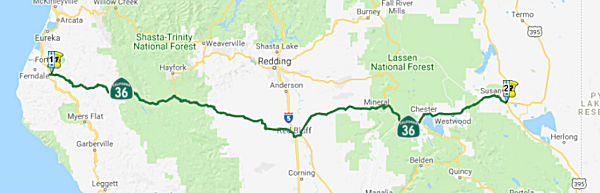 Route 101 near Alton to Route 395 near Johnsonville passing
near Forest Glen via Red Bluff and Mineral, via the vicinity of Morgan
Summit, and via Susanville.
Route 101 near Alton to Route 395 near Johnsonville passing
near Forest Glen via Red Bluff and Mineral, via the vicinity of Morgan
Summit, and via Susanville.
 Post 1964 Signage History
In 1963, Route 36 was defined as "(a) Route 101 near Alton to Route 5 near Red Bluff passing near Kuntz and Peanut. (b) Route 5 at Red Bluff to Route 395 via Mineral, via the vicinity of Morgan, and via Susanville. (c) Route 139 north of Susanville to Route 395 near Ravendale." Later that year, Chapter 1698 changed Kuntz to Mad River and Ravendale to Termo. In 1968, Chapter 282 changed the wording again, this time adjusting "Mad River" to "Forest Glen". Then, in 1984, Chapter 409 changed "Morgan" to "Morgan Summit".
Note: See Route 172 for some history of the former routings of Route 36.
 In July 1964, a relocation of Route 36 in Susanville
occurred. The new highway replaced a winding narrow section (now Segments
1 and 2 of County Sign Route A27) constructed in 1931, which had 13 curves and a minimum
radius of 500'. Two of the curves were signed for 35 mph. During this
work, the existing 2-lane highway was converted to a 64' all paved
section, changing to a 40' all paved section outside of the Susanville
city limits. The portion of the highway constructed will be the westbound
lanes of an ultimate 4 lane freeway. Per CHPW, right of way has been
purchased and fenced for ultimate interchanges at the E city limits of
Susanville and at the junction of Route 36 and US 395.
In July 1964, a relocation of Route 36 in Susanville
occurred. The new highway replaced a winding narrow section (now Segments
1 and 2 of County Sign Route A27) constructed in 1931, which had 13 curves and a minimum
radius of 500'. Two of the curves were signed for 35 mph. During this
work, the existing 2-lane highway was converted to a 64' all paved
section, changing to a 40' all paved section outside of the Susanville
city limits. The portion of the highway constructed will be the westbound
lanes of an ultimate 4 lane freeway. Per CHPW, right of way has been
purchased and fenced for ultimate interchanges at the E city limits of
Susanville and at the junction of Route 36 and US 395.
Scott Parker (Sparker) on AAroads provided some additional information on
the proposed segment (c), Route 139 N of Susanville to Route 395:
(Source: Scott Parker (Sparker) on AAroads, "Re: CA-36: Proposed ending in Ravendale?", 3/26-28/2019)
The various iterations of the California Freeway & Expressway System, starting back in 1959, proposed a new-terrain Route 36 extension from Route 139 near Eagle Lake ENE to US 395 near Ravendale. US 395 was part of the system north of the future Route 36 junction (all the way to the OR state line) -- but not south of there to present Route 36 near Johnstonville. Also, Route 139 was part of the system between its southern terminus at Route 36 in Susanville and where the Route 36 extension diverged at Eagle Lake; all of the original Route 36 plus US 395 south of Route 36 all the way to the NV state line was also included in the system. This leads one to surmise that the ultimate plans were to reroute US 395 into Susanville, subsuming the eastern end of Route 36 and the southern end of Route 139, and returning to its original alignment via the new Route 36 extension. Whether the portion of US 395 between the old and new CA 36 alignments would have been retained in the state highway system or simply designated with a new number isn't determined [ -- and the segment was later deleted from the system.] The portion of US 395 between the two iterations of Route 36 (Johnstonville, Ravendale) would have been, absent any legislative action, part of the state highway system. That segment, however, was never included in the state "freeway & expressway" network; the local N-S through route on that network included US 395 north to Johnstonville, where the designated expressway continued west on Route 36 to Susanville, north on Route 139 to near Eagle Lake, and then over the new-terrain Route 36 extension back to US 395 at Ravendale. [It is possible that] the Route 36 number as applied to the extension was a "placeholder" so US 395 could continue on its then (and current) alignment pending the completion of the new extension. If and when that extension was completed, it's more than likely US 395 itself would have been rerouted over the expressway-designated section as described above. The Johnstonville-Ravendale original US 395 segment could receive a new designation. At that point Route 139 would terminate (south) at US 395 near Eagle Lake, Route 36 would terminate at US 395 in Susanville, and the bypassed US 395 section would receive a new numerical designation (unless Caltrans extended Route 36 over it, which would produce a pretty awkward alignment!).
In 1988, the first two segments were combined into a new segment (a): "Route 101 near Alton to Route 395 near Johnsonville passing near Forest Glen and Peanut via Red Bluff and Mineral, via the vicinity of Morgan Summit, and via Susanville." In 1990, the reference to "Peanut" was deleted.
Lastly, in 1998, the remaining segment (b) "from Route 139 north of Susanville to Route 395 near Termo" was deleted by AB 2132, Chapter 877, signed September 26, 1998. That segment was LRN 20 to US 395 (LRN 73), and was defined in 1959. That section was never constructed; the traversable local roads included S. Grasshopper Road, Westside Road, and Fillman Road. Those roads were not on a proper alignment for construction as a state highways, and there were no plans for a freeway or expressway.
The route between Route 36 near Deer Creek Pass and Route 36 near Morgan Summit is cosigned as Route 36/Route 89, although it is legislatively Route 36.
 Pre 1964 Signage History
In 1934, Route 36 was signed along the route from Jct. US 101 near Scotia to Jct. Route 7 (later US 395) E of Susanville, via Red Bluff. The route had the following legislative routes:
Tom Fearer, in his Gribblenation blog post "California State Route 36", provides more details on the history. The follow is condensed from that blog post; see the blog post for more
details and maps.
(Source: Gribblenation Blog, "California State Route 36")
What is now Route 36 between Red Bluff east to Susanville was constructed during the 1860s as a part of two wagon routes. The first segment of highway that would be adopted as part of future Route 36 was a route between the communities of Kuntz (now Mad River) and Peanut (approximately) by way of 1907 Legislative Chapter 117 (segment 2 above). In time this segment of highway between Kuntz and Peanut would come to be known as LRN 35. The 1909 First State Highway Bond Act added several additional pieces of highway that would be come part of future Route 36: (1) A small portion of LRN 3 between the Oregon State Line south to Sacramento would carry Route 36 on a multiplex with future US 99 (segment 4 above), and LRN 29 east from Red Bluff to Susanville by way of Mineral Summit. The 1919 Third State Highway Bond Act extended LRN 29 east to the Nevada State Line. Future Route 36 would utilize LRN 29 from Susanville to future Route 7/US 395. In 1933, LRN 35 west extended west from Mad River to LRN 1/US 101 in Alton along with LRN 29 being was extended west from Red Bluff and LRN 35. That completed the initial Route 36. In 1933, LRN 86 from Lassen Volcanic National Park-Mineral Road to Mineral along with LRN 83 (which ended at LRN 29) to Morgan were also added to the State Highway System; these became part of the history of Route 36 when it was realigned over Morgan Summit. It is unclear when Route 36 moved off of LRN 29 over Mineral Summit. There seems to be some evidence that Route 36 may have been realigned over Morgan Summit by 1940. The 1940 Division of Highways State Map shows LRN 86/LRN 83 paved over Morgan Summit whereas Mineral Summit on LRN 29 is still shown to be a Oiled Earth or Gravel surface.
 In 1955, it was reported that the California Highway Commission (CHC) adopted
re-routings for two sections of Route 36 in Tehama County. Equivalent
post-1964 postmiles are unclear. There are two sections: (a) a five mile
section between 7 and 12 mi. W of Red Bluff, and (b) a 5½ mi. section
between Dry Creek and Button Canyon, about 20 mi. W of Red Bluff. In the
(a) section, the existing highway was narrow and winding, and required 13
ford crossings of Dibble Creek. In the (b) section, the road was narrow,
had many short curves, and crosses Button Canyon Creek by ford many times.
The realigned route for (a) generally parallels the present highway but
eliminates the numerous dip crossings of the creek and many curves. The
realignment for (b) also generally parallels the present highway, except
for a 1 mi. section just W of Dry Creek where it cuts across a loop the
present route makes to the N.
In 1955, it was reported that the California Highway Commission (CHC) adopted
re-routings for two sections of Route 36 in Tehama County. Equivalent
post-1964 postmiles are unclear. There are two sections: (a) a five mile
section between 7 and 12 mi. W of Red Bluff, and (b) a 5½ mi. section
between Dry Creek and Button Canyon, about 20 mi. W of Red Bluff. In the
(a) section, the existing highway was narrow and winding, and required 13
ford crossings of Dibble Creek. In the (b) section, the road was narrow,
had many short curves, and crosses Button Canyon Creek by ford many times.
The realigned route for (a) generally parallels the present highway but
eliminates the numerous dip crossings of the creek and many curves. The
realignment for (b) also generally parallels the present highway, except
for a 1 mi. section just W of Dry Creek where it cuts across a loop the
present route makes to the N.
(Source: Observer, 12/14/1955, via Joel Windmiller,
1/27/2023)
 In 1954, it was announced that the CHC had adopted a new routing for a 4.5 mi section of
Sign Route 36 W of Mineral (today ~ TEH R78.065 to TEH 83.134). The new
route swings to the S of the existing highway for a little more than half
of the 4.5 mi then follows the lines of the present highway to Mineral.
Plans at the time called for the building of a modern two-lane highway
over the route. Looking at current maps, it appears the previous highway
is now an unnamed road that connects with Road 140A, which then comes back
to Route 36. Note that the 1954 adoption map also shows that Route 36 had
been routed onto LRN 86, with "Route 29" (LRN 29) now an unsigned route
(eventual Route 172)
In 1954, it was announced that the CHC had adopted a new routing for a 4.5 mi section of
Sign Route 36 W of Mineral (today ~ TEH R78.065 to TEH 83.134). The new
route swings to the S of the existing highway for a little more than half
of the 4.5 mi then follows the lines of the present highway to Mineral.
Plans at the time called for the building of a modern two-lane highway
over the route. Looking at current maps, it appears the previous highway
is now an unnamed road that connects with Road 140A, which then comes back
to Route 36. Note that the 1954 adoption map also shows that Route 36 had
been routed onto LRN 86, with "Route 29" (LRN 29) now an unsigned route
(eventual Route 172)
(Source: Corning Daily Observer, 9/22/1954 via Joel Windmiller,
1/27/2023)
 Status
Alton Shoulder Widening Project (01-Hum-36, PM 0.1/1.65) (PPNO 2379)
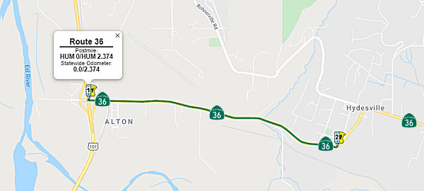 In March 2019, the CTC approved the California Department of
Transportation’s (Department) request for an additional $451,000 for
the State Highway Operation Protection Program (SHOPP) Collision Severity
Reduction project (PPNO 2379) on Route 36, in Humboldt County, near
Fortuna, from Route 101 to River Bar Road (~ HUM 0.00 to HUM 2.374). to
supplement the pre-construction component support cost (COS) for Project
Approval and Environmental Document (PA&ED). The project will
construct two 12-foot wide lanes, two 5-foot wide shoulders, install
center-line and shoulder rumble strips, and place an Open-Graded Friction
Course (OGFC) pavement throughout the project limits. The project also
includes a grade reduction on two short vertical curves to improve sight
distance. The project was programmed in the 2016 SHOPP, and in June 2017,
the Commission approved support cost funds in the amount of $1,005,000 for
the Project Approval and Environmental Documentation (PA&ED)
pre-construction phase. The total current allotment for the PA&ED
phase support cost is $1,305,500, including Department delegated G-12
funds. The original estimate for the PA&ED support cost was developed
prior to 2017, and it was based on the staff support and resources needed
to obtain required permits and Right of Way (R/W) certifications as
identified in the Project Initiation Document (PID). The original scope
was to widen shoulders on both sides of the roadway; however, the
Department changed strategies to widen the roadway on one side only due to
the discovery of unstable slope conditions on one side of the roadway.
This slope stability condition was discovered during geotechnical studies
conducted after the project programming phase. The COS was calculated
based on identified tasks needed to complete the PA&ED and on
information and data available prior to the discovery of the soil
stability condition. The additional widening on one side also resulted in
a greater impact to a wetland that was not factored in the original COS
estimate. To construct this project, and to provide an adequate area for
the roadway shoulder and recovery zone, the Department had planned to
acquire R/W from an operational truck and logging mill site. However, the
planned R/W acquisition did not include an existing, private property used
as a wood waste berm. The berm location within the private property was
recently changed to an area that encroaches on the planned project site.
This change occurred after the original COS estimate was completed, and
will require additional, unanticipated site investigation. Because of the
expanded wood waste berm, the Department will be required to conduct
additional studies to evaluate new hazardous waste contamination. The
additional analysis, which will require subsurface drilling and soil
sampling, will also require additional support costs to re-evaluate the
property’s possible contamination under the recently changed
condition. The increased support cost is also needed to account for staff
work associated with obtaining or updating all required permits to
complete the PA&ED phase, and to conduct additional R/W negotiations
associated with obtaining temporary permits to enter property that was not
included in the original studies.
In March 2019, the CTC approved the California Department of
Transportation’s (Department) request for an additional $451,000 for
the State Highway Operation Protection Program (SHOPP) Collision Severity
Reduction project (PPNO 2379) on Route 36, in Humboldt County, near
Fortuna, from Route 101 to River Bar Road (~ HUM 0.00 to HUM 2.374). to
supplement the pre-construction component support cost (COS) for Project
Approval and Environmental Document (PA&ED). The project will
construct two 12-foot wide lanes, two 5-foot wide shoulders, install
center-line and shoulder rumble strips, and place an Open-Graded Friction
Course (OGFC) pavement throughout the project limits. The project also
includes a grade reduction on two short vertical curves to improve sight
distance. The project was programmed in the 2016 SHOPP, and in June 2017,
the Commission approved support cost funds in the amount of $1,005,000 for
the Project Approval and Environmental Documentation (PA&ED)
pre-construction phase. The total current allotment for the PA&ED
phase support cost is $1,305,500, including Department delegated G-12
funds. The original estimate for the PA&ED support cost was developed
prior to 2017, and it was based on the staff support and resources needed
to obtain required permits and Right of Way (R/W) certifications as
identified in the Project Initiation Document (PID). The original scope
was to widen shoulders on both sides of the roadway; however, the
Department changed strategies to widen the roadway on one side only due to
the discovery of unstable slope conditions on one side of the roadway.
This slope stability condition was discovered during geotechnical studies
conducted after the project programming phase. The COS was calculated
based on identified tasks needed to complete the PA&ED and on
information and data available prior to the discovery of the soil
stability condition. The additional widening on one side also resulted in
a greater impact to a wetland that was not factored in the original COS
estimate. To construct this project, and to provide an adequate area for
the roadway shoulder and recovery zone, the Department had planned to
acquire R/W from an operational truck and logging mill site. However, the
planned R/W acquisition did not include an existing, private property used
as a wood waste berm. The berm location within the private property was
recently changed to an area that encroaches on the planned project site.
This change occurred after the original COS estimate was completed, and
will require additional, unanticipated site investigation. Because of the
expanded wood waste berm, the Department will be required to conduct
additional studies to evaluate new hazardous waste contamination. The
additional analysis, which will require subsurface drilling and soil
sampling, will also require additional support costs to re-evaluate the
property’s possible contamination under the recently changed
condition. The increased support cost is also needed to account for staff
work associated with obtaining or updating all required permits to
complete the PA&ED phase, and to conduct additional R/W negotiations
associated with obtaining temporary permits to enter property that was not
included in the original studies.
(Source: March 2019 CTC Minutes, Agenda Item
2.5e.(1))
In October 2020, the CTC approved
for future consideration of funding the following project for which a
Mitigated Negative Declaration (MND) has been completed: Route 36 in
Humboldt County (01-Hum-36, PM 0.1/1.65). Widen shoulders on Route 36 in
Humboldt County. (PPNO 2379) The Department proposes to reduce run-off
collisions by widening Route 36 in Humboldt County near Alton between post
miles (PMs) 0.1 to 1.65. This collision severity reduction project will
construct two 12 foot wide lanes and 8 foot shoulders (5 feet paved and 3
feet unpaved), install center-line rumble strips, and place rubberized hot
mix asphalt (gap graded) throughout. The project includes a grade
reduction on two short vertical curves to improve sight distance as well.
The project is currently programmed in the 2020 State Highway Operation
and Protection Program (SHOPP) for a total of $16,504,000 which includes
Construction (capital and support) and Right of Way (capital and support).
Construction is estimated to begin Fiscal Year 2023-2024. The scope, as
described for the preferred alternative, is consistent with the project
scope programmed by the California Transportation Commission in the 2020
SHOPP.
(Source: October 2020 CTC Agenda, Agenda Item
2.2c.(1))
In October 2020, the CTC approved the following SHOPP
Support Phase allocation: $1,173,000 ($50K over original programming) for
PS&E and $861,000 for R/W Sup for 01-Hum-36 PM 0.1/1.7. PPNO 01-2379
ProjID 0113000090 EA 0E010. On Route 36 near Fortuna, from Route 101 to
River Bar Road. Shoulder widening. (Concurrent consideration of funding
under Resolution E-20-85; October 2020.)
(Source: October 2020 CTC Agenda, Agenda Item
2.5b.(2a) #2)
Carlotta Shoulder Widening Project (01-Hum-36 3.9/6.0)
 In January 2021, the CTC approved the following pre-construction support phase
allocation(s): (2a) #1. $3,187,000 (PA&ED) for 01-Hum-36 3.9/6.0. PPNO
01-2525 ProjID 0119000119 EA 0J890. Route 36 Near Carlotta, from west of
Fisher Road to west of Wilder Road. Widen shoulders, extend westbound
passing lane, construct soft median and rumblestrips, replace bridge,
construct soldier pile wall and upgrade guardrail. Prog Year 23-24.
(Concurrent Amendment under SHOPP Amendment 20H-005; January 2021.)
In January 2021, the CTC approved the following pre-construction support phase
allocation(s): (2a) #1. $3,187,000 (PA&ED) for 01-Hum-36 3.9/6.0. PPNO
01-2525 ProjID 0119000119 EA 0J890. Route 36 Near Carlotta, from west of
Fisher Road to west of Wilder Road. Widen shoulders, extend westbound
passing lane, construct soft median and rumblestrips, replace bridge,
construct soldier pile wall and upgrade guardrail. Prog Year 23-24.
(Concurrent Amendment under SHOPP Amendment 20H-005; January 2021.)
(Source: January 2021 CTC Agenda, Agenda Item
2.5b.(2a) #1)
In late September 2022, public meetings were held
regarding proposed improvements along Route 36 in Humboldt County from
Hydesville to Carlotta. The Carlotta Shoulder Widening Project proposes
safety improvements on Route 36 between Hill Lane near Hydesville and
Wilson Lane in Carlotta (PM HUM 3.9 to 6.0). These upgrades include
six-foot minimum shoulders, rumble strips, guardrail upgrades, culvert
replacements, a westbound passing lane extension at Ward Creek, a new
bridge with a curve improvement at Ward Creek, a new maintenance turnout,
and a curve improvement near Monroe Lane. The draft environmental
document, an Initial Study with Mitigated Negative Declaration (IS/MND),
was circulated for public comment in September 2022. Environmental studies
and preliminary design are scheduled to be completed in April 2023, and
construction is scheduled for summer 2024.
(Source: Carlotta Widening Project Page, 10/2022)
According to the draft EIR: Structural features for the
project include replacing a 10-foot-wide x 60-foot-long culvert with a
single span bridge at Ward Creek (PM 4.39). SB 857 requires projects be
constructed without presenting barriers to fish passage. The new bridge
would ensure the primary safety features of the project can be constructed
in compliance with SB 857. The purpose of the proposed new Ward Creek
Bridge would be to accommodate a widened highway that would include the
westbound passing lane extension and shoulder widening, and would
eliminate barriers to fish passage. The proposed bridge would be 60 feet
wide with a span of 45 feet. This bridge would accommodate three
12-foot-wide lanes (eastbound, westbound, and westbound passing), two
10-foot-wide shoulders, and would include a vehicular and bicycle
bridge rail. The most likely type of bridge deck would be a
pre-cast/pre-stressed concrete slab with a depth of 1 foot 9 inches. The
bridge type would be determined during the final design phase. Pile
driving would likely be required to install the new pre-cast abutments.
The corner sight distance at Fisher Road is expected to be improved with
the proposed eastbound shoulder widening, grading, and clearing and
grubbing activities. This is the beginning of the shoulder widening for
the project, which would extend eastward to PM 6.0. Additional grading,
clearing, and grubbing to improve the sight distance at this intersection
would be incorporated into the project.
(Source: CARLOTTA SHOULDER WIDENING PROJECT INITIAL STUDY with Proposed Mitigated Negative Declaration , DISTRICT 1 – HUM – 36 (Post Miles 3.90 to 6.00), EA 01-0J890 / EFIS 01-1900-0119, September 2022)
In terms of realignment: A slight improvement to the
curve radius and super elevation would occur at the Ward Creek curve
approximately located between PM 4.32 and PM 4.60, which would shift
the centerline approximately seven feet to the north. Upon
completion of construction, the extended westbound passing lane, located
between PM 4.31 and PM 4.79, would be 12 feet wide and 3,700 feet long. A
minor highway realignment is proposed between PM 5.60 and PM 5.96, with a
maximum offset of 6.1 feet from the existing centerline. At this location,
the adjacent roadside consists of a small area of unpaved shoulder. The
existing alignment also includes four curves, two of which make up a
compound curve (also called an “S” curve). The proposed
alignment would include three curves, eliminating the existing compound
curve. A new eastbound turnout is proposed near PM 5.61. The proposed
turnout would be 400 feet long by 15 feet wide. The existing radar speed
feedback sign located at PM 5.90 is proposed to be removed. A new radar
feedback sign would be installed at PM 5.85 in conjunction with the
existing 45 mile per hour (mph) sign at the beginning of the speed zone at
PM 5.85. A maintenance vehicle pullout to service the sign would be
included in the final project design.
(Source: CARLOTTA SHOULDER WIDENING PROJECT INITIAL STUDY with Proposed Mitigated Negative Declaration , DISTRICT 1 – HUM – 36 (Post Miles 3.90 to 6.00), EA 01-0J890 / EFIS 01-1900-0119, September 2022)
Hydraulics and environmental work includes removing
driveway cross-culvert and replace with 24-inch diameter culvert
(approximately PM 4.37); removal of an existing structural plate pipe arch
culvert (6-foot 10-inch-tall with a length of 60 feet and a width of
10-foot 8-inches) and replacment with a new Ward Creek single span bridge
(PM 4.39); replacement of a double barrel 24-inch-diameter corrugated
metal pipe culvert in-kind (PM 5.29); and removal of an existing
18-inch-diameter concrete culvert and replace with a 24-inchdiameter
Alternative Pipe Culvert (PM 5.90). Two redwood trees greater than 3 feet
diameter at breast height (DBH) would be removed from the northwest bank
of Ward Creek to accommodate the facility widening and new bridge. The new
bridge would include features to improve wildlife passage under the
highway. The project would also include in-stream restoration work for
fish passage in Ward Creek at PM 4.39. The proposed stream channel
restoration work at Ward Creek would extend an estimated 50 feet upstream
and 160 feet downstream of the new bridge. Additionally, an old bridge,
located approximately 100 feet downstream of the current alignment, was
relinquished to a private property owner prior to 1970. This bridge would
be demolished and removed. The creek area would be recontoured and
revegetated to reduce erosion, and to enhance riparian and aquatic
habitat.
(Source: CARLOTTA SHOULDER WIDENING PROJECT INITIAL STUDY with Proposed Mitigated Negative Declaration , DISTRICT 1 – HUM – 36 (Post Miles 3.90 to 6.00), EA 01-0J890 / EFIS 01-1900-0119, September 2022)
In June 2023, the CTC approved for future consideration
of funding 01-Hum-36, PM 3.90/6.00. Carlotta Shoulder Widening
Project: Route 36 in Humboldt County. Widen shoulders, extend
westbound passing lane, construct soft median and rumble strips, replace
bridge, construct soldier pile wall, and upgrade guardrail, in Humboldt
County. (PPNO 2525). The project is located on Route 36 from postmile 3.90
to PM 6.00, in Humboldt County. The Department proposes to widen
shoulders, extend westbound passing lane, construct soft median and rumble
strips, replace bridge, construct soldier pile wall, and upgrade
guardrail. The project is currently programmed in the 2022 State Highway
Operation and Protection Program (SHOPP) for a total of $29,357,000, which
includes Right of Way (Support and Capital) and Construction (Support and
Capital). Construction is estimated to begin 2024-25. The scope, as
described for the preferred alternative, is consistent with the project
scope as programmed by the Commission in the 2022 SHOPP. A copy of the MND
has been provided to Commission staff. The project will result in less
than significant impacts to the environment after mitigation. The
following resource area may be impacted by the project: wetlands.
Avoidance, minimization, and mitigation measures will reduce any potential
effects on the environment. These measures include, but are not limited
to, mitigating for permanent impacts to wetlands by applying credits from
the Fen Parcel Agreement. As a result, a MND was completed for this
project.
(Source: June 2023 CTC Agenda, Agenda Item 2.2c.(1))
In June 2023, the CTC approved the following SHOPP
Pre-Construction Phase (environmental support, design, and R/W support)
allocation: $2,985,000. 01-Hum-36 3.9/6.0. PPNO 01-2525; ProjID
0119000119; EA 0J890. Route 36 Near Carlotta, from west of Fisher Road to
west of Wilder Road. Widen shoulders, extend westbound passing lane,
construct soft median and rumble strips, replace bridge, construct soldier
pile wall and upgrade guardrail. Concurrent consideration of funding under
Resolution E-23-81; June 2023. Concurrent Amendment under SHOPP Amendment
22H-009; June 2023. Allocation (Programmed / Allocated):
PS&E $2,383,000 / $2,383,000; R/W Sup $506,000 / $602,000.
(Source: June 2023 CTC Agenda, Agenda Item 2.5b.(2a) #1)
Carlotta Curve Correction 01-Hum-36 10.5/10.8
 The following project was included in the final adopted 2018 SHOPP in March 2018: PPNO 2415. 01-Humboldt-36 10.5/10.8. On Route 36 Near Carlotta, from 0.1 mile east of Riverside Park Road to 0.4
mile east of Riverside Park Road. Curve correction. Begin Con: 7/1/2020.
Total Project Cost: $5,074K.
The following project was included in the final adopted 2018 SHOPP in March 2018: PPNO 2415. 01-Humboldt-36 10.5/10.8. On Route 36 Near Carlotta, from 0.1 mile east of Riverside Park Road to 0.4
mile east of Riverside Park Road. Curve correction. Begin Con: 7/1/2020.
Total Project Cost: $5,074K.
In June 2019, the CTC approved the following scope
amendment to the SHOPP: 01-Hum-36 10.5/10.8 PPNO 2415 ProjID 0115000076.
Route 36 Near Carlotta, from 0.1 mile east of Riverside Park Road to 0.4
mile east of Riverside Park Road. Curve correction. Note: Original design
would have unknowingly severed access to a private timber road. Cost and
schedule changes are required to account for a new strategy to raise the
profile of the roadway, decrease grade differential, and improve sight
distance. More time and resources are required for archeological surveys,
cultural review, coordination with permitting agencies, and to redesign
the project. Updated total cost: $6,063K Updated const. FY20-21.
(Source: June 2019 CTC Minutes, Agenda Item
2.1a.(1) Scope Item 1)
The 2020 SHOPP, approved in May 2020, included the
following Collision Reduction item of interest (carried over from the 2018
SHOPP): 01-Humboldt-36 PM 10.5/10.8 PPNO 2415 Proj ID 0115000076 EA 0F160.
Route 36 near Carlotta, from 0.1 mile east of Riverside Park Road to 0.4
mile east of Riverside Park Road. Curve correction. Programmed in FY20-21,
with construction scheduled to start in Sept 2021. Total project cost is
$6,063K, with $2,990K being capital (const and right of way) and $3,073K
being support (engineering, environmental, etc.),
(Source: 2020 Approved SHOPP a/o May 2020)
In October 2020, the CTC approved for future
consideration of funding the following project for which a Mitigated
Negative Declaration (MND) has been completed: Route 36 in Humboldt
County. Improve curves and widen shoulders on Route 36 in Humboldt County.
(01-Hum-36, PM 10.5/10.8) (PPNO 2415) This project is located in Humboldt
County. The project proposes to improve safety on Route 36 near the town
of Carlotta. This project is currently programmed in the 2020 SHOPP for a
total of $6,063,000, which includes Construction (capital and support) and
Right of Way (capital and support). Construction is estimated to begin
2021-2022. The scope, as described for the preferred alternative, is
consistent with the project scope programmed by the Commission in the 2020
SHOPP.
(Source: October 2020 CTC Agenda, Agenda Item
2.2c.(1))
In October 2020, the CTC approved the following SHOPP
Support Phase allocation: $1,044,000 ($946,000 budgeted) for PS&E, and
$174,000 for R/W Sup for 01-Hum-36 PM 10.5/10.8. PPNO 01-2415 ProjID
0115000076 EA 0F160. On Route 36 near Carlotta, from 0.1 mile east of
Riverside Park Road to 0.4 mile east of Riverside Park Road. Curve
correction. (Concurrent consideration of funding under Resolution E-20-86;
October 2020.)
(Source: October 2020 CTC Agenda, Agenda Item
2.5b.(2a) #3)
In June 2021, the CTC was informed of the following
SHOPP Safety Resolution G-03-10 Delegated Allocation: $4,150,000.
01-Hum-36 10.5/10.8. PPNO 01-2415; ProjID 0115000076; EA 0F160). On Route 36 Near Carlotta, from 0.1 mile east of Riverside Park Road to 0.4 mile
east of Riverside Park Road. Outcome/Output: Improve safety by realigning
curves, improve cross slope, widen shoulders, construct retaining
wall, overlay pavement, replace culverts, and install guardrail.
This project will reduce the number and severity of collisions. (Future
consideration of funding approved under Resolution E-20-86; October 2020.)
Allocation Date: 05/17/2021 Allocation: CON ENG $1,043,000; CONST
$2,678,000.
(Source: June 2021 CTC Agenda, Agenda Item 2.5f.(3)
#1)
Hely Creek Bridge / Little Larabee Creek Bridge / Butte Creek Bridge Upgrades and Replacements (01-Hum-36 11.3/34.6)
 In August 2011, the CTC approved $9.5 million in SHOPP
funding for repairs near Carlotta, from 1.7 miles east of Route 36/US 101
Junction to Van Duzen River Bridge (HUM 012.78); also near Bridgeville,
from Van Duzen River Bridge to 1.7 miles east of Little Larabee Creek
Bridge (~ HUM 023.57). This project will rehabilitate 37.2 lane miles of
roadway to improve the ride quality, prevent further deterioration of the
traveling surface, minimize costly roadway repairs and extend the pavement
service life. They also approved $1,365,000 for a project that will repair
slipouts and slope failures at four locations damaged by heavy rainfall on
Route 36 near Bridgeville. The project limits are from 0.7 mile west of
Bridgeville Post Office to 0.3 mile east of Little Larabe Creek Bridge.
In August 2011, the CTC approved $9.5 million in SHOPP
funding for repairs near Carlotta, from 1.7 miles east of Route 36/US 101
Junction to Van Duzen River Bridge (HUM 012.78); also near Bridgeville,
from Van Duzen River Bridge to 1.7 miles east of Little Larabee Creek
Bridge (~ HUM 023.57). This project will rehabilitate 37.2 lane miles of
roadway to improve the ride quality, prevent further deterioration of the
traveling surface, minimize costly roadway repairs and extend the pavement
service life. They also approved $1,365,000 for a project that will repair
slipouts and slope failures at four locations damaged by heavy rainfall on
Route 36 near Bridgeville. The project limits are from 0.7 mile west of
Bridgeville Post Office to 0.3 mile east of Little Larabe Creek Bridge.
In June 2021, the CTC approved the following amendment
to the 2020 SHOPP: 01-Hum-36 11.3/34.6 PPNO 2363 ProjID 0112000292 EA
01-0C500, Route 39 Near Bridgeville, at Hely Creek Bridge No. 04-0092,
Little Larabee Creek Bridge No. 04-0102 (PM 25.3),and Butte Creek Bridge
No. 04-0116. Upgrade bridge rails and widen at one bridge, and
replace two bridges. Note: The reduction in R/W capital is due to multiple
projects utilizing early acquisition process to secure an offsite parcel
for mitigation which decreased the anticipated mitigation cost. R/W Cap $1,470K
$1,015K; Total $27,014K $26,559K.
(Source: June 2021 CTC Agenda/Minutes, Agenda Item
2.1a.(1d) #5)
In August 2021, the CTC approved for future
consideration of funding 01-Hum-36, PM 11.46/34.52. Hum-36 Three
Bridges Project. Replace two bridges, upgrade bridge rails, and
widen at one bridge on Route 36 in Humboldt County. (MND) (PPNO 2363)
(SHOPP). This project is located on Route 36 from post mile 11.4 to 34.5,
in Humboldt County. The Department proposes to upgrade bridge rails and
shoulder widths of the Hely Creek Bridge, Little Larabee Creek Bridge, and
Butte Creek Bridge to meet current design standards. The existing Hely and
Butte Creek bridges will be replaced, and the Little Larabee Creek Bridge
will be widened. This project is currently programmed in the 2020 State
Highway Operation and Protection Program (SHOPP) for a total of
$26,559,000, of which, $19,730,000 is currently through G-13 Contingency
which includes Construction (capital and support). Construction is
estimated to begin in 2022. The scope, as described for the preferred
alternative, is consistent with the project scope as programmed by the
Commission in the 2020 SHOPP. A copy of the MND has been provided to
Commission staff. The project will result in less than significant
impacts to the environment after mitigation. The following resource
areas may be impacted by the project: biological resources.
Avoidance and minimization measures will reduce any potential effects on
the environment. These measures include, but are not limited to, the
proposed purchase of a wetland mitigation site that contains an important
step-fen and approximately 115-acres of mixed conifer hardwood forest that
contributes to the fen's watershed. As a result, an MND was completed for
this project.
(Source: August 2021 CTC Agenda, Agenda Item
2.2c.(1))
Also in August 2021, the CTC approved the following
preconstruction allocation: 01-Hum-36 11.3/34.6. PPNO 01-2363; ProjID
0112000292; EA 0C500. Route 36 Near Bridgeville, at Hely Creek Bridge
№ 04-0092, Little Larabee Creek Bridge № 04-0102 (PM 25.3),
and Butte Creek Bridge № 04-0116. Upgrade bridge rails and widen at
one bridge, and replace two bridges. (G13 Contingency) (Concurrent
consideration of funding under Resolution E-21-72; August 2021.) (Four
month time extension for PS&E and R/W Sup approved under Waiver 21-59;
June 2021.) Allocation: PS&E $2,622,000, R/W Sup $245,000.
(Source: August 2021 CTC Agenda, Agenda Item
2.5b.(2b) #1)
In August 2022, the CTC amended this project in the
SHOPP as follows: 01-Hum-36 11.3/34.6. PPNO 01-2363; ProjID 0112000292; EA
0C500. Route 36 Near Bridgeville, at Hely Creek Bridge № 04-0092,
Little Larabee Creek Bridge № 04-0102 (PM 25.3), and Butte Creek
Bridge № 04-0116. Upgrade bridge rails and widen at one
bridge, and replace two bridges. Allocation Changes ($ × 1,000): Con
Sup $0 ⇨ $3,932; R/W Cap $1,105 ⇨ $997; Const Cap: $0 ⇨
$15,029; Total $6,829 ⇨ $25,772. Concurrent CONST and CON ENG
allocation under Resolution FP-22-10; August 2022. Note: Split
environmental mitigation project EA 0C501/PPNO 01-2363M from parent
project EA 0C500/PPNO 01-2363. Fully program previously unfunded phases of
this G13 Contingency project.
(Source: August 2022 CTC Agenda, Agenda Item
2.1a.(1d) #1)
In August 2022, the CTC approved the following
construction phase allocation: $22,450,000. 01-Hum-36 11.3/34.6. PPNO
01-2363; ProjID 0112000292; EA 0C500. Route 36 Near Bridgeville, at Hely
Creek Bridge № 04-0092, Little Larabee Creek Bridge № 04-0102
(PM 25.3), and Butte Creek Bridge № 04-0116. Outcome/Output:
Upgrade bridge rails and widen at one bridge, and replace two bridges.
Programmed Allocation: CON ENG: $3,932,000; CONST $15,029,000. CEQA - MND,
6/10/2021; Re-validation 6/24/2022; NEPA - CE, 6/10/2021; Re-validation
6/24/2022. Future consideration of funding approved under Resolution
E-21-72; August 2021. As part of this allocation request, the Department
is requesting to extend the completion of CONST and CON ENG an additional
4 months beyond the 36 month deadline. Two month time extension for CONST
and CON ENG approved under Waiver 22-73; June 2022.
(Source: August 2022 CTC Agenda, Agenda Item
2.5b.(1) #2)
Emergency Repairs near Bridgeville: 01-Hum-36 19.0/44.0
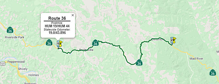 In May 2017, the CTC approved $1.85M in SHOPP funding for emergency repairs
near Bridgeville, from 0.3 mile west of Jaymar Lane to 1.7 miles west of
Trinity County line (01-Hum-36 19.0/44.0). Beginning on January 7, 2017, a
series of storm events caused multiple slides, sinkholes, slipouts, and
distressed pavement. Responding day and night to the damages, Department
forces were inundated beyond the Department's capacity. The project will
remove and dispose of slide debris and hazardous trees, support ongoing
geotechnical investigations, and repair roadway. This work is necessary to
stabilize storm damaged slopes and embankments prior to subsequent rain
events, prevent lane closures, and restore safe passage for the traveling
public. They also approved an additional $1.125M in overlapping emergency
repairs near Bridgeville, 1.3 miles west of McClellan Mountain Road to 0.3
mile west of McClellan Mountain Road (01-Hum-36 29.0/30.0). On January 7,
2017, a storm event caused a slipout of a steep roadway embankment with a
60 foot by 40 foot scarp remaining and surface tension cracks in asphalt.
As per geotechnical recommendations, the project will repair slipout,
place rock slope protection to strengthen embankment armament, minimize
surface drainage, and repair roadway. This work is necessary to halt the
degradation of embankment and prevent lane loss or road closures. This is
a critical route for travel between north coast and inland communities
given the ongoing long-term closure of Route 299.
In May 2017, the CTC approved $1.85M in SHOPP funding for emergency repairs
near Bridgeville, from 0.3 mile west of Jaymar Lane to 1.7 miles west of
Trinity County line (01-Hum-36 19.0/44.0). Beginning on January 7, 2017, a
series of storm events caused multiple slides, sinkholes, slipouts, and
distressed pavement. Responding day and night to the damages, Department
forces were inundated beyond the Department's capacity. The project will
remove and dispose of slide debris and hazardous trees, support ongoing
geotechnical investigations, and repair roadway. This work is necessary to
stabilize storm damaged slopes and embankments prior to subsequent rain
events, prevent lane closures, and restore safe passage for the traveling
public. They also approved an additional $1.125M in overlapping emergency
repairs near Bridgeville, 1.3 miles west of McClellan Mountain Road to 0.3
mile west of McClellan Mountain Road (01-Hum-36 29.0/30.0). On January 7,
2017, a storm event caused a slipout of a steep roadway embankment with a
60 foot by 40 foot scarp remaining and surface tension cracks in asphalt.
As per geotechnical recommendations, the project will repair slipout,
place rock slope protection to strengthen embankment armament, minimize
surface drainage, and repair roadway. This work is necessary to halt the
degradation of embankment and prevent lane loss or road closures. This is
a critical route for travel between north coast and inland communities
given the ongoing long-term closure of Route 299.
In August 2018 the CTC received a report of $1,200,000
in SHOPP funding for Humboldt 01-Hum-36 19.0/44.0: Route 36 Near
Bridgeville, from 0.3 mile west of Jaymar Lane to 1.7 miles west of
Trinity County line. Beginning on January 7, 2017, a series of storm
events caused multiple slides, sinkholes, slipouts, and distressed
pavement. Responding day and night to the damages, Department forces were
inundated beyond the Department's capacity. The project will remove and
dispose of slide debris and hazardous trees, support ongoing geotechnical
investigations, and repair roadway. Supplemental work that consists of
temporary shoring, excavation, guardrail repair, and construction of
Hilfiker Welded Wire retaining wall is needed to address additional slides
(PM 3.0 and PM 15.8) that are in proximity to existing work limits.
Additional supplemental work necessary to complete drainage work at PM
16.21, 16.24, and 43.42. This supplemental will also allow for the
completion of work while maintaining the route open to traffic at PM 31.4.
This has been subject to a series of allocations:
(Source: August 2018 CTC Agenda Item 2.5f.(1) Item
1)
In October 2018, there was additional emergency funding
of $12,200,000 for this effort.
(Source: October 2018 CTC Agenda Item 2.5f(1) Item
1)
In September 2009, the CTC relinquished right of way in the county of Humboldt along Route 36 near Bridgeville at Kneeland Road (~ HUM R23.91), consisting of superseded highway right of way.
Dinsmore Realignment (1-Hum-36 36.6/39.9)
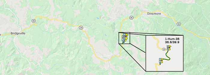 In October 2015, the CTC approved the following SHOPP funding: 1-Hum-36
36.6/39.9 Route 36 Near Dinsmore, from west of Burr Valley Road to west of
Buck Mountain Road. Widen to make lane and shoulder widths standard,
realign curves, and improve roadway cross-slope. PAED: 10/01/2015 R/W:
07/01/2016 RTL: 07/15/2016 CCA: 12/01/2018. $231K (R/W) $7,441K (C)
Completion FY16/17. Support costs: PA & ED $90K; PS & E $75K; RW
Sup $150K; Con Sup $40; Total $355K
In October 2015, the CTC approved the following SHOPP funding: 1-Hum-36
36.6/39.9 Route 36 Near Dinsmore, from west of Burr Valley Road to west of
Buck Mountain Road. Widen to make lane and shoulder widths standard,
realign curves, and improve roadway cross-slope. PAED: 10/01/2015 R/W:
07/01/2016 RTL: 07/15/2016 CCA: 12/01/2018. $231K (R/W) $7,441K (C)
Completion FY16/17. Support costs: PA & ED $90K; PS & E $75K; RW
Sup $150K; Con Sup $40; Total $355K
In June 2016, the CTC amended the SHOPP funding for a project on Route 36 In and near Dinsmore, on Route 36 (Forest Highway 4). PM 36.1/40.5. Roadway improvements. Increases to support are due to unanticipated increased land surveys, Right of Way capital, Right of Way support, and environmental mitigation staff work to complete the project and coordinate with the Federal Lands partnership to construct the project. Right of Way capital increases are caused by increased utility relocations. These changes add $2,372,000 to the cost of the project. Additionally, there was also an amendment to a parallel project near Dinsmore (PM 36.6/39.9), from west of Burr Valley Road to west of Buck Mountain Road. Widen to make lane and shoulder widths standard, realign curves, and improve roadway cross-slope. Right of Way support cost has increased due to unplanned additional survey work to monument the new state right of way and to record maps in accordance with State law. Previously this work was assumed to be addressed by Federal Lands participation on project. This change in responsibility adds $510,000 to the cost of the project. The two projects were also going to be combined for construction.
In October 2016, the CTC approved the following SHOPP allocation: 01-Hum-36 36.1/40.5 | Route 36 Near Dinsmore, from west of Burr Valley Road to Buck Mountain Road. (Forest Highway 4). Outcome/Output: Improve highway operations and mobility along 4.4 miles by realigning, widening, upgrading geometrics and providing long term roadway stability. $6,142,000. It also approved the following SHOPP allocation: 01-Hum-36 36.6/39.9 | Route 36 Near Dinsmore, from west of Burr Valley Road to west of Buck Mountain Road. (Forest Highway 4). Outcome/Output: Widen to make lane and shoulder widths standard, realign curves, and improve roadway cross slopes. This project will improve safety by reducing the number and severity of collisions. $7,481,000
In November 2016, it was reported that in mid-October,
the California Transportation Commission approved a resolution which
allocated the state’s share of the money for the Route 36 project
(01-Hum-36, PM 36.1/40.5), along with 13 other State Highway Operation and
Protection Program (SHOPP) projects throughout California. Specifics of
the project near Dinsmore include realigning and widening Route 36, making
the lanes and shoulder widths standard, realigning curves, and improving
roadway cross slopes. This will be the last section of Route 36 to become
a conventional two-lane highway. The project is expected to begin in the
summer of 2017. The Route 36 project is a partnership between Caltrans and
the Federal Highway Administration (FHA) with the FHA contributing a
greater share of the funding. It’s estimated that the FHA will put
in more than $20 million, with the State of California paying more than
$13 million for the project. The construction project will improve an
approximately 4-mile section of Route 36 from Burr Valley Road to Buck
Mountain Road.
(Source: Humboldt Beacon, 11/2/2016)
In April 2018, it was reported that work was
progressing on the Route 36 widening, and that there was a website providing updates on the construction. That website
describes the project as follows: "The California Department of
Transportation (Caltrans) and the Federal Highway Administration, Central
Federal Lands Highway Division (FHWA -CFLHD), in cooperation with the U.S.
Forest Service, Six Rivers National Forest, are improving California State
Route 36 (SR 36) in southeastern Humboldt County approximately 12.3 miles
east of the community of Bridgeville (Humboldt County mile post 36.0 to
40.4). Improvements include realigning and widening SR 36 to attain two,
12-foot wide travel lanes with 4-foot wide paved shoulders. In addition,
new signing, pavement markings, guardrail, and wetland restoration are
included in the project. CFLHD is the lead agency for compliance with the
National Environmental Policy Act (NEPA) and Caltrans is the lead agency
for compliance with the California Environmental Quality Act (CEQA)." It
also provides links to the EIR.
(Source: Route 36 Website)
Forest Glen Realignment
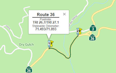 In January 2017, the CTC approved for future
consideration of funding a project that will realign the roadway and
construct a bridge on Route 36 near the community of Forest Glen
(02-Tri-36, PM 26.7/27.1) (roughly from east of Post Mountain Road to the
intersection with Route 3). The project will result in less than
significant impacts to the environment after mitigation. The following
resource area may be impacted by the project: biological resources.
Avoidance and minimization measures will reduce any potential effects on
the environment. These measures include, but are not limited to, sound
generated by construction activity will be limited to 90 decibels within
1,320 feet of northern spotted owl nesting areas during the period from
February 1 to July 9, a qualified biologist will be on site during clear
water diversion activities to monitor for western pond turtles and
foothill yellow-legged frogs.
In January 2017, the CTC approved for future
consideration of funding a project that will realign the roadway and
construct a bridge on Route 36 near the community of Forest Glen
(02-Tri-36, PM 26.7/27.1) (roughly from east of Post Mountain Road to the
intersection with Route 3). The project will result in less than
significant impacts to the environment after mitigation. The following
resource area may be impacted by the project: biological resources.
Avoidance and minimization measures will reduce any potential effects on
the environment. These measures include, but are not limited to, sound
generated by construction activity will be limited to 90 decibels within
1,320 feet of northern spotted owl nesting areas during the period from
February 1 to July 9, a qualified biologist will be on site during clear
water diversion activities to monitor for western pond turtles and
foothill yellow-legged frogs.
In June 2018, the CTC was informed of the following
SHOPP allocation: 2.5f(3) Item 1: $8,345,000. 02-Tri-36 26.7/27.1. PPNO
3526. On Route 36 Near Forest Glen, from 0.6 to 0.1 mile west of Route 3.
Outcome/Output: Improve
safety by reducing the number of curves from five to two, and by providing
standard lane width and 4 foot shoulders. This project will reduce the
number and severity of collisions.
(Source: CTC Agenda, June 2018 Agenda Item 2.5f(3) Item 1)
In October 2018, the CTC approved a request for an
additional $3,608,000 for the State Highway Operation Protection Program
(SHOPP) Safety Improvement project (PPNO 02-3526) on Route 36 in Trinity
County, to award the construction contract. This project is located on
Route 36 in Trinity County near Forest Glen. The total accident rate is 17
times higher than the statewide average for similar routes. The project
will improve the roadway safety by realigning this portion of highway,
significantly improving the horizontal alignment by constructing a bridge
to eliminate several compound and reversing curves with radii as small as
110 feet. The project will widen lane and shoulder widths to 12 feet and 4
feet respectively. Super elevation transitions, vertical and horizontal
sight distances will also be improved. The contract award status is
pending approval of this request for supplemental funds by the Commission.
If the Commission approves this request, construction, would begin in
November 2018, and would take 190 working days to be completed in November
2021. Since June 2018, the Department has been experiencing higher bids on
contracts that include bridge work throughout Northern California due to
the limited pool of contractors bidding on Department and other
non-Department contracts. In addition, there has been a decreasing number
of subcontractors available to prime contractors for specialized
construction items. Out-of-region contractors bidding on these projects
charge higher prices due to mobilization, equipment, material hauling, and
overhead. Some of the complex items on this contract include constructing
the bridge’s 80-foot-tall piers and support falsework due to the
bridge’s remote location and shortage of material. Additional
problems included the fact that this type of embankment cannot be
constructed using standard embankment equipment, which would damage the
geosynthetic fabric. Furthermore, the contractor states that this
operation is labor intensive and has a low production rate because of the
use of smaller equipment to avoid fabric damage, and due to hand laying of
the fabrics.
(Source: October 2018 CTC Agenda Item 2.5e.(4))
Route 3 near Peanut to I-5 near Red Bluff
Curve Improvements near Plantina (02-Tri-36 R34.7/R35.3)
In December 2016, the CTC added the following project to the SHOPP: 2-Tri-36 R34.7/R35.3 | Route 36 Near Platina, from 3.7 miles to 3.0 miles west of Hayfork Creek Bridge. Curve improvement. Allocation: $52K (R/W), $5.280MM (C), Support (PA & ED $760K / PS & E $1.13MM / RW Sup $130K / Con Sup $1.68MM / Total $3.7MM). FY 19/20.
The following project was included in the final adopted 2018 SHOPP in March 2018: PPNO 3653. 02-Trinity-36 R34.7/R35.3. Route 36 Near Platina, from 3.7 miles to 3.0 miles west of Hayfork Creek Bridge. Curve improvement. Begin Con: 7/15/2020. Total Project Cost: $9,032K.
In May 2020, the CTC was informed of the following
SHOPP Safety Allocation that occurred in March 2020: $8,230,000 02-Tri-36
R34.8/R35.4. PPNO 02-3653 ProjID 0216000093 EA 2H050. Route 36 near
Platina, from 3.6 miles to 2.9 miles west of Hayfork Creek Bridge.
Outcome/Output: Improve safety by realigning curves and correcting cross
slope, widening lanes and shoulders, installing guardrail, and increasing
clear recovery zone. This project will reduce the number and severity of
collisions. (As part of this allocation request, the Department is
requesting to extend the award of the construction contract an additional
6 months beyond the 6 month deadline.) Allocation Date: 03/05/20.
(Source: May 2020 CTC Agenda, Agenda Item 2.5f.(3)
#4)
Curve Improvements near Red Bluff (TEH 12.6/13.1)
In June 2016, the CTC amended a project into the SHOPP: Route 36 near Red Bluff, from 2.3 miles east to 2.8 miles east of Dry Creek Bridge. Curve improvement. Estd. completion around 2020.
The following project was included in the final adopted 2018 SHOPP in March 2018: PPNO 3640. 02-Tehama-36 12.6/13.1. Route 36 Near Red Bluff, from 2.3 miles east to 2.8 miles east of Dry Creek Bridge. Curve improvement. Begin Con: 11/29/2019. Total Project Cost: $5,156K.
In October 2019, the CTC approved the following SHOPP
Safety allocation: 02-Teh-36 12.6/13.1. PPNO 3640 Proj ID 0216000051 EA
1H970. On Route 36 Near Red Bluff, from 2.3 miles east to 2.8 miles east
of Dry Creek Bridge. Outcome/Output: Improve safety by realigning curves
and correcting cross slope, widening lanes and shoulders, installing
guardrail, increasing clear recovery zone, and placing Rock Slope
Protection (RSP) along the creek bank. This project will reduce the number
and severity of collisions. $3,708,000.
(Source: October 2019 CTC Agenda, Agenda Item
2.5f.(3) #2)
Curve Realingment near Salt Creek Bridge (02-Teh-36 15.7/16.1)
In August 2022, the CTC amended the following project
into the SHOPP:02-Teh-36 15.7/16.1. PPNO 02-3862; ProjID 0222000055; EA
3J520. Route 36 Near Red Bluff, from 3.5 miles west to 3.1 miles west of
Salt Creek Bridge. Realign curve, widen shoulders, and
upgrade guardrail. Allocation ($ × 1,000): PA&ED $970; PS&E
$770; R/W Sup $240; Con Sup $810; R/W Cap $162; Const Cap: $2,638; Total
$5,590. Begin Const: 1/6/2026. Concurrent COS allocation under Resolution
FP-22-11; August 2022.
(Source: August 2022 CTC Agenda, Agenda Item
2.1a.(1a) #17)
In August 2022, the CTC approved the following
pre-construction phase allocation: $970,000. 02-Teh-36 15.7/16.1. PPNO
02-3862; ProjID 0222000055; EA 3J520. Route 36 Near Red Bluff, from 3.5
miles west to 3.1 miles west of Salt Creek Bridge. Realign curve,
widen shoulders, and upgrade guardrail. Allocation: FY 25-26
PA&ED $970,000. Concurrent Amendment under SHOPP Amendment
22H-003; August 2022.
(Source: August 2022 CTC Agenda, Agenda Item 2.5b.(2a) #6)
Curve Improvement W of Basler Road (02-Teh-36 26.6/27.6)
The following project was included in the final adopted 2018 SHOPP in March 2018: PPNO 3663. 02-Tehama-36 26.6/27.6. Route 36 Near Red Bluff, from west of Basler Road to east of Diamond Star Road. Curve improvement. Begin Con: 7/14/2020. Total Project Cost: $7,141K.
In May 2020, the CTC was informed of the following
allocation, which took place in April 2020: $4,893,000 02-Teh-36
26.6/27.6. PPNO 02-3663 ProjID 0216000156 EA 2H630. Route 36 near Red
Bluff, from 0.3 mile west of Basler Road to 0.1 mile east of Diamond Star
Road. Outcome/Output: Improve safety by realigning curves and correcting
cross slope, widening lanes and shoulders, increasing clear recovery zone
and sight distance, and replacing drainage systems. This project will
reduce the number and severity of collisions. (As part of this allocation
request, the Department is requesting to extend the award of the
construction contract an additional 6 months beyond the 6 month deadline.)
Allocation Date: 04/01/20.
(Source: May 2020 CTC Agenda, Agenda Item 2.5f.(3)
#3)
In July 2020, it was reported that Caltrans District 2,
in conjunction with Tullis Inc., has begun work on the Diamond Star Curve
Project on Route 36 in Tehama County. The $2.3 million project is
realigning the highway approximately 14 miles west of Red Bluff, from just
west of Basler Road to just east of Diamond Star Road. Road connections at
Basler Road, Easterbunny Drive, and Diamond Star Road will be
reconstructed to conform to new alignment in the area. Other work
includes: (·) Reconstruction of drainage facilities; (·)
Construction of new four-foot paved shoulders and shoulder backing; and
(·) New traffic delineation in area.
(Source: Redheaded Blackbelt, 7/25/2020)
In December 2008, the CTC vacated right of way in the county of Tehama along Route 36 east of Cannon Road near Red Bluff (2-Teh-36-PM 29.0/T29.0), and west of Kinney Avenue near Red Bluff (2-Teh-36-PM 37.7/38.1), consisting of highway right of way no longer needed for State highway purposes.
In February 2006, the CTC considered relinquishment of right of way in the County of Tehama, at Kinney Avenue (~ TEH R38.39), consisting of reconstructed and relocated county roads.
In October 2016, it was reported that Caltrans presented their ideas and
plans to rework Route 36 near the northern tip of Red Bluff to the Red
Bluff City Council. The work would realign Route 36 between where it and
Main Street split in north Red Bluff and where it intersects with Baker
Road (~ TEH 39.72 to TEH R41.196), said Clint Burkenpas, project manager
with the California Department of Transportation in Northern California.
Caltrans presented four alternatives for what the highway would look like
to the Red Bluff City Council as Burkenpas' team prepares the plan for
state approval. They are looking to replace the highway, one of four north
of the Bay Area that reach the coast, because its current route doesn't
have wide enough shoulders and needs improved intersections to meet modern
standards. They also want to make the currently diagonal railroad crossing
shoot straight across. The options for the new highway are similar, though
some differences do exist — some call for the old roadway to be used
as a bike and pedestrian path parallel with the new flatter, straighter
highway.
(Source: Redding Record-Searchlight, 10/31/2016)
In December 2008, the CTC relinqished 2-Teh-5-PM R27.5; 2-Teh-36-PM L40.3 Right of way in the city of Red Bluff on Adobe Road between Route 5 and Route 36, consisting of a reconstructed and relocated city street.
I-5 near Red Bluff to Route 89 near Mineral
In July 2017, it was reported that the CTC has approved $5.6 million for
the Route 36 East sidewalk and transportation project in Red Bluff
spanning from the East Sand Slough Bridge to 0.6 mile east of Stice Road
(~ TEH 42.027 to TEH 45.404). As part of the project on Route 36, there
will be work on the pavement including rehabilitation by grinding roadway,
performing dig-outs in localized areas of failure and overlaying with
rubberized asphalt to extend its service life and improve ride quality.
There will be upgrades done to existing Americans with Disabilities Act
curb ramps. The new sidewalks will be constructed and a bicycle lane will
be added with pavement markings through funding from the county’s
Congestion Mitigation and Air Quality account by the Tehama County
Transportation Commission, which previously committed $800,555 for the
project.
(Source: Red Bluff Daily News, 7/6/2017)
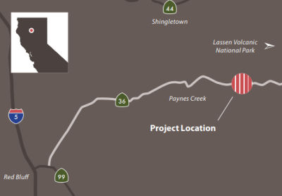
In August 2016, the CTC approved $14,000,000 for Tehama 02-Teh-36 R75.1/78.4 Route 36 near Mineral, from Little Giant Mill Road to 0.7 mile west of Diamond Road. Outcome/Output: realigning highway curves, improving drainage facilities and clear recovery zone, increasing shoulder widths, and installing guard rail to reduce the number and severity of collisions.
Lassen Lodge Safety Improvement Project (~ TEH 83.181)
 As reported in the Summer 2018 Mile Marker, Caltrans District 2 and contractor Tullis Inc. rebuilt the section of Route 36 in Tehama County near the community
of Mineral. The Lassen Lodge project began in May 2017 and was completed
that November, before the end of the construction season when weather
typically closes in on the area. Construction took only 121 days,
considered quite a feat since 200,000 cubic yards of rock and soil were
moved. The project was designed to reduce the frequency and severity of
accidents by straightening some of its curvy features and strengthening
the roadbed. The total accident rate along this stretch of highway was
more than three times higher than the statewide average for similar
routes. This three-mile-plus segment of roadway consisted of a series of
tight curves with designated speeds as low as 20 mph. The project features
an alignment that now meets current federal large truck design standards
(although the California Legal Truck length designation will not change
until several other issues are addressed along the corridor). The improved
roadway geometrics, and wider shoulders (four feet to eight feet) increase
sight distance and provide a larger recovery area for motorists. Other
project benefits include increased sun exposure to help melt snow and ice,
improved culverts and drainage facilities, and new guardrail. Native
materials were used to reduce potential erosion and improve overall
stability of the embankments in the steep terrain. Available rocky
material from specified cuts was used to fortify embankments. The
contractor crushed rock on site for all rock slope protection and drain
rock material. In addition, old asphalt was recycled into roadway base
rock, and mulch derived from vegetation removed for the project was spread
over the flatter slopes to reduce surface erosion. Processing materials on
site had the added benefit of reducing truck trips and emissions. The $9.5
million project was paid for with state and federal funds.
As reported in the Summer 2018 Mile Marker, Caltrans District 2 and contractor Tullis Inc. rebuilt the section of Route 36 in Tehama County near the community
of Mineral. The Lassen Lodge project began in May 2017 and was completed
that November, before the end of the construction season when weather
typically closes in on the area. Construction took only 121 days,
considered quite a feat since 200,000 cubic yards of rock and soil were
moved. The project was designed to reduce the frequency and severity of
accidents by straightening some of its curvy features and strengthening
the roadbed. The total accident rate along this stretch of highway was
more than three times higher than the statewide average for similar
routes. This three-mile-plus segment of roadway consisted of a series of
tight curves with designated speeds as low as 20 mph. The project features
an alignment that now meets current federal large truck design standards
(although the California Legal Truck length designation will not change
until several other issues are addressed along the corridor). The improved
roadway geometrics, and wider shoulders (four feet to eight feet) increase
sight distance and provide a larger recovery area for motorists. Other
project benefits include increased sun exposure to help melt snow and ice,
improved culverts and drainage facilities, and new guardrail. Native
materials were used to reduce potential erosion and improve overall
stability of the embankments in the steep terrain. Available rocky
material from specified cuts was used to fortify embankments. The
contractor crushed rock on site for all rock slope protection and drain
rock material. In addition, old asphalt was recycled into roadway base
rock, and mulch derived from vegetation removed for the project was spread
over the flatter slopes to reduce surface erosion. Processing materials on
site had the added benefit of reducing truck trips and emissions. The $9.5
million project was paid for with state and federal funds.
Morgan Summit Project / Curve Improvement Near Mineral (TEH 87.8/89.1)
In May 2016, the CTC approved additional SHOPP funding on Route 36 near Mineral, from 0.1 mile to 1.2 miles east of Route 89 for curve improvement.
The following project was included in the final adopted 2018 SHOPP in March 2018: PPNO 3641. 02-Tehama-36 87.8/88.8. Route 36 Near Mineral, from 0.1 mile to 1.2 miles east of Route 89. Curve improvement. Begin Con: 10/15/2019. Total Project Cost: $7,606K.
In June 2019, the CTC approved the following SHOPP
scope amendment: 02-Teh-36 87.8/88.8 87.8/89.1
PPNO 3641 ProjID 0216000052. Near Mineral, from 0.1 mile to 1.2
1.5 miles east of Route 89. Curve improvement. Increase R/W
capital to fund a separate service contract for early tree removal.
Increase construction capital to reflect the most recent trends in bid
price item increases to traffic control, asphalt, drainage, and stormwater
items. This project will combine with minor project EA 2H140 for
construction, and the post mile refinement will allow limits for the
projects to match. Updated total cost: $8,581K.
(Source: June 2019 CTC Minutes, Agenda Item
2.1a.(1) Scope Item 20)
In August 2019, the CTC approved the following SHOPP
Safety allocation: 02-Teh-36 87.8/89.1. PPNO 3641 Proj ID 0216000052 EA
1H740. On Route 36 Near Mineral, from 0.2 mile to 1.5 miles east of Route 89. Outcome/Output: Improve safety by realigning curves, widen lanes to 12
feet, pave shoulders to four feet, and improve sight distance and clear
recovery zone. This project will reduce the number and severity of
collisions. $6,949,000
(Source: August 2019 CTC Agenda, Agenda Item
2.5f.(3) #3)
In April 2020, it was reported that Caltrans District
2/North Region Construction and Steve Manning Construction was beginning
construction of the Morgan Summit Project. The approximately $6.4 million
curve realignment project will improve Route 36 near the town of Mineral,
from 0.10 miles to 1.50 miles east of Route 89, near the south entrance to
Lassen Volcanic National Park. It will take an estimated 95 working days
to complete. This project will improve the roadway alignment, sight
distance and clear recovery areas as well as roadway safety, rideability
and sustainability. The current alignment will be improved by reducing the
number of curves from 14 to 6 and by widening shoulders in both
directions. New guardrail, drainage systems, roadside signs, markers,
delineators, and striping will also be installed.
(Source: Plumas News, 4/10/2020)
In January 2013, the CTC approved SHOPP funding for reports on the Mill Creek Bridge in Tehama County near Mineral (~ TEH 091.46). Work there will replace rock slope protection at the abutment and pier to prevent further scouring and maintain structural integrity.
Route 89 near Mineral to US 395 near Susanville
In August 2008, the CTC vacated right of way along Route 36 in the county of Tehama, between 0.1 and 0.3 miles northwest of the intersection with Route 32 (~ TEH 99.68), consisting of highway right of way no longer needed for State highway purposes.
County Sign Route A13 Roundabout ( 02-Plumas-36 PM R13.6/R14.2)
The 2020 SHOPP, approved in May 2020, included the
following Collision Reduction item of interest (carried over from the 2018
SHOPP): 02-Plumas-36 PM R13.6/R14.2 PPNO 3759 Proj ID 0219000145 EA 0J640.
Route 36 near Chester, from 0.3 mile west to 0.3 mile east of County Sign Route A13.
Construct roundabout. Programmed in FY22-23, with construction scheduled
to start in August 2023. Total project cost is $8,658K, with $4,988K being
capital (const and right of way) and $3,670K being support (engineering,
environmental, etc.). Note that this was amended into the 2018 SHOPP at
the May 2020 meeting as well.
(Source: 2020 Approved SHOPP a/o May 2020; May 2020
CTC Agenda, Agenda Item 2.1a.(1a) #25)
In May 2020, the CTC approved the following support
allocation: 02-PLU-36 R13.6/R14.2. PPNO 3759 ProjID 0219000145. EA 0J640.
Route 36 Near Chester, from 0.3 mile west to 0.3 mile east of County Road
A13. Construct roundabout. Allocation: PA&ED $940,000.
(Source: May 2020 CTC Agenda, Agenda Item 2.5b.(2)
#2)
In June 2021, it was reported that the CTC approved
funding for the County Sign Route A13 at Route 36 Safety project near Chester, which will
provide intersection improvements, and construct a roundabout.
Specifically, at the June 2021 meeting, the CTC approved the following
preliminary pre-construction allocation: 02-PLU-36 R13.6/R14.2; PPNO 3759;
ProjID 0219000145; EA 0J640. Route 36 Near Chester, from 0.3 mile west to
0.3 mile east of County Road A13. Construct roundabout. Allocation: R/W
Sup $190,000 (22-23)
(Source: Plumas News, 6/25/2021; June 2021 CTC Agenda, 2.5b.(2a) #4)
In October 2021, the CTC approved the following
allocation for preconstruction project phases: $1,190,000. 02-Plu-36
R13.6/R14.2. PPNO 02-3759; ProjID 0219000145; EA 0J640. Route 36 Near
Chester, from 0.3 mile west to 0.3 mile east of County Road A13. Construct
roundabout. Allocation: PS&E $1,190,000.
(Source: October 2021 CTC Agenda, Agenda Item
2.5b.(2a) #2)
In August 2023, the CTC received a report of an SHOPP
Safety Sub-Allocation made by Caltrans on 07/12/2023:$7,276,000. 02-Plu-36
R13.6/R14.2. PPNO 02-3759; ProjID 0219000145; EA 0J640. Route 36 Near
Chester, from 0.3 mile west to 0.3 mile east of County Sign Route A13. Outcome/Output:
Improve safety by constructing roundabout. This project will reduce
the number and severity of collisions. Preliminary Engineering (Budget / Expended):
PA&ED $940,000 / $568,612; PS&E $1,190,000
/ $1,033,639; R/W Sup $190,000 / $134,183.
CEQA - CE, 12/13/2021; Re-validation 6/19/2023. NEPA - CE, 12/13/2021;
Re-validation 6/19/2023. Two month allocation time extension for CONST and
CON ENG approved under Waiver 23-72; June 2023. Allocation Date:
07/12/2023. Allocation (Programmed / Allocated): CON ENG
$1,350,000 / $1,350,000;CONST $4,980,000 / $5,926,000.
(Source: August 2023 CTC Agenda, Agenda Item 2.5f.(3) #3)
In December 2023, the CTC considered a supplemental
allocation of $2,210,000 (37.3 percent increase) in Construction Capital
for 02-Plu-36 R13.6/R14.2, PPNO 02-3759; ProjID 0219000145; EA 0J640.
Route 36 Near Chester, from 0.3 mile west to 0.3 mile east of County Road
A13. Improve safety by constructing roundabout. Outcome/Output: This
project will reduce the number and severity of collisions. Supplemental
funds are needed to Award. CEQA - CE, 12/13/2021; Re-validation 6/19/2023
NEPA - CE, 12/13/2021; Re-validation 6/19/2023 Total revised amount
$8,136,000. In August 2023, the Department advertised the contract and
held bid opening in October 2023. The contract received three bids,
of which the lowest bid is 34.1 percent above the Engineer’s
Estimate (EE). The remaining bids are 39.2 and 82.0 percent over the
EE. The cost increases on this project are largely attributed to the need
for four separate mobilizations of major operations and anticipated slower
production rate. Risks associated with slower production are reflected in
the item prices. The bidders indicated that the roundabout paving
items represent unique challenges when compared to linear operation. The
EE accounted for material prices, but elevated labor costs, stemming from
slower production rate and risk of rework to meet allowable tolerances,
surpassed the assumptions in the EE.
(Source: December 2023 CTC Agenda, Agenda Item 2.5e.(3))
Goodrich Creek Bridge (02-Las-36 7.2/7.4)
 The following project was included in the final adopted 2018 SHOPP in March 2018: PPNO 3512. 02-Lassen-36 7.2/7.4. On Route 36 Near Westwood, at Goodrich Creek Bridge No. 07-0048. Replace bridge.
Begin Con: 1/24/2020. Total Project Cost: $7,915K.
The following project was included in the final adopted 2018 SHOPP in March 2018: PPNO 3512. 02-Lassen-36 7.2/7.4. On Route 36 Near Westwood, at Goodrich Creek Bridge No. 07-0048. Replace bridge.
Begin Con: 1/24/2020. Total Project Cost: $7,915K.
In June 2018, the CTC approved for future consideration
of funding the following project: 02-Las-36, PM 6.0/14.6 Goodfred Bridge
Replacement and Roadway Rehabilitation: Project Replace existing bridge
and construct roadway improvements on Route 36 in Lassen County. (MND)
(PPNO 3468) (SHOPP). This project is located on Route 36 near Westwood in
Lassen County. The project proposes to replace the Goodrich Creek Bridge
(No. 07-0048) and rehabilitate 8.5 miles of Route 36. The proposed project
will also include roadway realignment, upgrading and/or installation of
culverts, inlet/outlet treatments at approximately 57 locations, and
shoulder widening. The project is programmed for both the roadway
rehabilitation and bridge replacement, and to be delivered in different
fiscal years. This proposed project is estimated to cost a total of $42.2
million. The project is currently programmed in the 2018 SHOPP for
approximately $29.9 million which includes Construction (capital and
support) and Right of Way (capital and support). The project is estimated
to begin construction in 2020. The scope, as described for the preferred
alternative, is consistent with the project scope programmed by the
Commission in the 2018 SHOPP.
(Source: CTC Agenda, June 2018 Agenda Item 2.2c(1))
In June 2019, the CTC approved the following scope
amendment to the SHOPP: 02-Las-36 7.2/7.4 PPNO 3512 ProjID 0213000006.
Near Westwood, at Goodrich Creek Bridge No. 07-0048. Replace bridge.
Increase to R/W capital for higher mitigation costs due to additional
wetland and riparian involvement that was not recognized prior to
receiving the detailed wetland delineation. Updated total cost: $8,048K.
(Source: June 2019 CTC Minutes, Agenda Item
2.1a.(1) Scope Item 18)
In January 2020, the CTC approved the following
financial allocation: #3. 02-Las-36 7.2/7.4. On Route 36 Near Westwood, at
Goodrich Creek Bridge No. 07-0048. Outcome/Output: Replace bridge
with a new single span pre-cast bridge, install new bridge rails, and
place Rock Slope Protection (RSP). Allocation: $5,601,000. (Future
consideration of funding approved under Resolution E-18-88; June 2018.)
(EA 4F560/PPNO 02-3512 combined with EA 4E460/PPNO 02-3468 for
construction under EA 4E46U/Project ID 0216000122.)
(Source: January 2020 CTC Agenda, Agenda Item
2.5b.(1) #3)
In September 2006, the CTC considered relinquishment of right of way at LAS PM 25.1 in the City of Susanville, at Foss Street, consisting of a road connection.
Skyline Road
 In June 2018, the CTC approved a new public road
connection: 02-Las-36-PM R26.9, New Public Road Connection to Route 36 at
Skyline Road in the county of Lassen. The City of Susanville, County of
Lassen (County) and Lassen County Transportation Commission (LCTC) propose
to construct a new public road connection to Route 36 at Skyline Road. The
new connection would complete the extension of Skyline Road from
Johnstonville Road in the city of Susanville to Route 36 in the county of
Lassen. The new connection will improve traffic circulation by providing
an efficient, alternate route for local and interregional trips on the
State Highway System, thereby reducing traffic congestion along central
urban arterials. Development in the northeast area of the city of
Susanville has increased traffic congestion through central Susanville.
Forecasted growth will add to the congestion on Route 36, Route 139 and
local roads. The 2012 SR 36 Transportation Concept Report supports the
project, which is consistent with the Lassen County Regional
Transportation Plan. Route 36 through the project limits was adopted as a
freeway by the California Highway Commission on July 20, 1960. Caltrans
denominated this segment as a controlled access highway on March 15, 1977.
Through the project limits, the facility is a two-lane expressway with
12-foot traveled ways and 8-foot shoulders. The route predominantly serves
local and regional traffic, with some longer interregional trips.
In June 2018, the CTC approved a new public road
connection: 02-Las-36-PM R26.9, New Public Road Connection to Route 36 at
Skyline Road in the county of Lassen. The City of Susanville, County of
Lassen (County) and Lassen County Transportation Commission (LCTC) propose
to construct a new public road connection to Route 36 at Skyline Road. The
new connection would complete the extension of Skyline Road from
Johnstonville Road in the city of Susanville to Route 36 in the county of
Lassen. The new connection will improve traffic circulation by providing
an efficient, alternate route for local and interregional trips on the
State Highway System, thereby reducing traffic congestion along central
urban arterials. Development in the northeast area of the city of
Susanville has increased traffic congestion through central Susanville.
Forecasted growth will add to the congestion on Route 36, Route 139 and
local roads. The 2012 SR 36 Transportation Concept Report supports the
project, which is consistent with the Lassen County Regional
Transportation Plan. Route 36 through the project limits was adopted as a
freeway by the California Highway Commission on July 20, 1960. Caltrans
denominated this segment as a controlled access highway on March 15, 1977.
Through the project limits, the facility is a two-lane expressway with
12-foot traveled ways and 8-foot shoulders. The route predominantly serves
local and regional traffic, with some longer interregional trips.
The Skyline Road project was initiated in the early
1990’s as a corridor project. The “Skyline Corridor”
included three phases: Skyline Road East (Route 139 to Johnstonville
Road), Skyline Road Extension (Johnstonville Road to Route 36) and Skyline
Road South (Route 36 to Richmond Road). This corridor project would
connect Route 139, Route 36, and Richmond Road just outside the city of
Susanville. All three phases were programmed for funding beginning in the
1998 State Transportation Improvement Program (STIP). Environmental work
began on all three phases and project alternatives were determined for
Skyline Road East and Skyline Road Extension. The County decided to
proceed with Skyline Road East and Skyline Road Extension but Skyline Road
South was delayed. Both Skyline Road East and Skyline Road Extension have
been top priorities for the LCTC and the community. Skyline Road East and
Skyline Road Extension both proceeded through environmental clearance
simultaneously in 1999. Due to funding restraints, the County determined
that it was not feasible to continue both projects simultaneously so it
was decided to complete Skyline Road East first while still moving forward
with Skyline Road Extension. The Skyline Road East phase was completed in
July 2008. Once Skyline Road Extension phase is completed, the LCTC will
seek funding and proceed with Skyline Road South. The Skyline Road
Extension would lengthen Skyline Road from Johnstonville Road and connect
to Route 36 at PM R26.9 with an at-grade three-way signalized
intersection, about 0.2 miles southeast of the Susan River Bridge (Br. No.
07-0033). The Skyline Road Extension will construct a two-lane undivided
roadway with 12-foot lanes, 8-foot shoulders and an adjacent paved Class I
Bikeway. Route 36 will be widened to accommodate an eastbound left-turn
lane and a westbound right-turn lane to the new Skyline Road. The
estimated project cost for this road connection is $1,680,000 utilizing
STIP and local funding. Upon completion of the Skyline Road Extension,
interregional and local traffic from communities south of Susanville will
be able to use Skyline Road as an expedient route to reach destinations
north of the city of Susanville. Trucks and recreational vehicles
travelling between Reno, Nevada to Klamath Falls, Oregon would also have
an alternate route instead of traveling through central Susanville.
(Source: CTC Agenda, June 2018 Agenda Item 2.3b(2))
 Historical Route
A small portion of this segment in Red Bluff is designated as part of "Historic US Highway 99" by Assembly Concurrent Resolution 19, Chapter 73, in 1993.
 Naming
 Fredonyer Pass (LAS 11.934) marks the high point on Route 36 between Red
Bluff on the west and Susanville on the east. This pass also marks the
approximate boundary between the Cascade Range to the north and the Sierra
Nevada to the south. Fredonyer Pass and nearby Fredonyer Mountain are
named for an early resident of the area, Atlas Fredonyer, who is credited
with discovery of the pass in 1850. Twelve years later the story takes a
bad turn. Fredonyer was indicted on May 7, 1862, for victimizing his own
daughter. He was “tried and convicted in Quincy (Plumas County seat)
for incestuous and criminal assault . . .” and sentenced to six
years in San Quentin Prison. He was released after a matter of months. He
was pardoned the next year by California Governor Leland Stanford. After
his pardon, Fredonyer seemed to have disappeared, as he never returned
back to this region. He surfaced in 1880 in San Francisco. At this time he
was suffering from bowel blockage. He attempted perform his own
colonoscopy, which a bottle, which got lodged in the colon. The
heavy set Fredonyer was finally taken to St. Mary’s hospital. A
colostomy was performed to remove the bottle. He did not recover
from the procedure and died in San Francisco on August 10, 1880. In 1995,
the California Assembly and Senate both acted in support of a resolution
which said in part: “Naming the mountain and pass after Atlas
Fredonyer, given his crimes and subsequent conviction, seems improper,
unacceptable, and undeserving . . .” The Legislative Counsel’s
Digest declared: “This measure would memorialize [ask or petition]
the United States Board on Geographic Names, United States Geological
Survey, to rename Fredonyer Mountain and Fredonyer Pass to Griffith
Mountain and Griffith Pass in honor of Deputy Sheriff Larry
Griffith.” “Water falling on the west side of Fredonyer Pass
will eventually flow into Lake Almanor and then down the Feather River to
the Sacramento. On the east side of Fredonyer water flows to the Susan
River and on eastward past Susanville.
Fredonyer Pass (LAS 11.934) marks the high point on Route 36 between Red
Bluff on the west and Susanville on the east. This pass also marks the
approximate boundary between the Cascade Range to the north and the Sierra
Nevada to the south. Fredonyer Pass and nearby Fredonyer Mountain are
named for an early resident of the area, Atlas Fredonyer, who is credited
with discovery of the pass in 1850. Twelve years later the story takes a
bad turn. Fredonyer was indicted on May 7, 1862, for victimizing his own
daughter. He was “tried and convicted in Quincy (Plumas County seat)
for incestuous and criminal assault . . .” and sentenced to six
years in San Quentin Prison. He was released after a matter of months. He
was pardoned the next year by California Governor Leland Stanford. After
his pardon, Fredonyer seemed to have disappeared, as he never returned
back to this region. He surfaced in 1880 in San Francisco. At this time he
was suffering from bowel blockage. He attempted perform his own
colonoscopy, which a bottle, which got lodged in the colon. The
heavy set Fredonyer was finally taken to St. Mary’s hospital. A
colostomy was performed to remove the bottle. He did not recover
from the procedure and died in San Francisco on August 10, 1880. In 1995,
the California Assembly and Senate both acted in support of a resolution
which said in part: “Naming the mountain and pass after Atlas
Fredonyer, given his crimes and subsequent conviction, seems improper,
unacceptable, and undeserving . . .” The Legislative Counsel’s
Digest declared: “This measure would memorialize [ask or petition]
the United States Board on Geographic Names, United States Geological
Survey, to rename Fredonyer Mountain and Fredonyer Pass to Griffith
Mountain and Griffith Pass in honor of Deputy Sheriff Larry
Griffith.” “Water falling on the west side of Fredonyer Pass
will eventually flow into Lake Almanor and then down the Feather River to
the Sacramento. On the east side of Fredonyer water flows to the Susan
River and on eastward past Susanville.
(Sources: Bill Sanford "Getting out of the Central
Valley: Highway passes to the east" (emailed draft 10/1/2010), Exploring Lassen County's Past; Image sources: Exploring Lassen County's Past; Roger Wendell "Waypoints, GPX Tracks Grid Squares, and Navigation")
 Griffith Pass (LAS 11.934) was named after a Lassen County peace officer
killed in the line of duty on March 2, 1995. In 1995, the California
Assembly and Senate both acted in support of a resolution which said in
part: “Naming the mountain and pass after Atlas Fredonyer, given his
crimes and subsequent conviction, seems improper, unacceptable, and
undeserving . . .” The Legislative Counsel’s Digest declared:
“This measure would memorialize [ask or petition] the United States
Board on Geographic Names, United States Geological Survey, to rename
Fredonyer Mountain and Fredonyer Pass to Griffith Mountain and Griffith
Pass in honor of Deputy Sheriff Larry Griffith.” Despite favorable
action by both houses of the legislature, the federal government
apparently did nothing.
Griffith Pass (LAS 11.934) was named after a Lassen County peace officer
killed in the line of duty on March 2, 1995. In 1995, the California
Assembly and Senate both acted in support of a resolution which said in
part: “Naming the mountain and pass after Atlas Fredonyer, given his
crimes and subsequent conviction, seems improper, unacceptable, and
undeserving . . .” The Legislative Counsel’s Digest declared:
“This measure would memorialize [ask or petition] the United States
Board on Geographic Names, United States Geological Survey, to rename
Fredonyer Mountain and Fredonyer Pass to Griffith Mountain and Griffith
Pass in honor of Deputy Sheriff Larry Griffith.” Despite favorable
action by both houses of the legislature, the federal government
apparently did nothing.
(Source: Bill Sanford "Getting out of the Central
Valley: Highway passes to the east" (emailed draft 10/1/2010); Image
source: Newspapers.Com)
 Route 36 near Susanville from LAS 25.356 at State Route 139 to LAS R29.390 at Junction US 395, in the County of Lassen is named
the “High Desert State Prison Correctional Officer Richard
Bianchi, Jr., Memorial Highway”. It was named in memory of
High Desert State Prison Correctional Officer Richard Bianchi, Jr., who
died in a single-vehicle crash in the early morning of June 25, 2020,
while on his way to provide security coverage at a Redding hospital.
Bianchi was born in October 1967, in Carmichael, California. Richard was
an accomplished athlete in cross-country running and wrestling during his
years at Lassen High School, and he continued through his passion for
sports as a coach and enthusiastic fan at his children’s sporting
events. Richard joined the United States Air Force in 1986, where he was
stationed at Scott Air Force Base in Illinois. Upon returning home from
his military service, Richard worked at his parents’ Midway
Café in Doyle, California while also enrolled at Truckee Meadows
Community College. Richard began his service with the Department of
Corrections and Rehabilitation on October 18, 2010, where he was a part of
the High Desert State Prison family since February 4, 2011. Richard was
known for treating his fellow officers, along with inmates of the High
Desert State Prison, with dignity and respect. Named by Assembly
Resolution ACR 32, Res. Chapter 110, Statutes of 2021, on 09/07/21.
Route 36 near Susanville from LAS 25.356 at State Route 139 to LAS R29.390 at Junction US 395, in the County of Lassen is named
the “High Desert State Prison Correctional Officer Richard
Bianchi, Jr., Memorial Highway”. It was named in memory of
High Desert State Prison Correctional Officer Richard Bianchi, Jr., who
died in a single-vehicle crash in the early morning of June 25, 2020,
while on his way to provide security coverage at a Redding hospital.
Bianchi was born in October 1967, in Carmichael, California. Richard was
an accomplished athlete in cross-country running and wrestling during his
years at Lassen High School, and he continued through his passion for
sports as a coach and enthusiastic fan at his children’s sporting
events. Richard joined the United States Air Force in 1986, where he was
stationed at Scott Air Force Base in Illinois. Upon returning home from
his military service, Richard worked at his parents’ Midway
Café in Doyle, California while also enrolled at Truckee Meadows
Community College. Richard began his service with the Department of
Corrections and Rehabilitation on October 18, 2010, where he was a part of
the High Desert State Prison family since February 4, 2011. Richard was
known for treating his fellow officers, along with inmates of the High
Desert State Prison, with dignity and respect. Named by Assembly
Resolution ACR 32, Res. Chapter 110, Statutes of 2021, on 09/07/21.
(Image source: Calif. Dept. of Corrections News Release, 6/27/2020)
 Named Structures
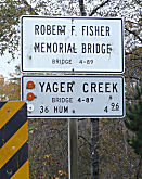 Bridge 04-0089 over Yager Creek in Humboldt county (HUM 004.96) is named the "Robert F. Fisher Memorial Bridge".
It was built in 1968, and named by Assembly Concurrent Resolution 151,
Chapter 282, in 1969. Robert F. Fisher, elected to the California Assembly
by the people of Humboldt County in 1926, 1928 and 1930, was the last
remaining Spanish-American War veteran in Humboldt County. Robert Fisher
was born in Plymouth, Devon in February 1879 and emigrated to America in
1885 with his parents, Charles Ponsford Fisher and Harriet Oyns Fisher.
The family settled in the mountains outside of San Diego, California. In
1898, Fisher enlisted in the Army during the Spanish–American War
and served 13 months in the Philippines with the Third Artillery. After
the war, he returned to the Philippines and ran a ligterage company for 12
years. He met his future wife, Bess Hayne Dawson, in Manila; they came
back to the United States to be married in August 1912. The young couple
took over management of his family's newly purchased ranch near Carlotta
in Humboldt County, California. Fisher was the first president of the
Humboldt County Farm Bureau and an early member of the Fortuna Rotary
Club. Fisher ran for state Assembly in Humboldt County the first time in
1926, won the seat and retained it for the next two elections in 1928 and
1930, serving until 1932. He was a member of the Republican party.
Bridge 04-0089 over Yager Creek in Humboldt county (HUM 004.96) is named the "Robert F. Fisher Memorial Bridge".
It was built in 1968, and named by Assembly Concurrent Resolution 151,
Chapter 282, in 1969. Robert F. Fisher, elected to the California Assembly
by the people of Humboldt County in 1926, 1928 and 1930, was the last
remaining Spanish-American War veteran in Humboldt County. Robert Fisher
was born in Plymouth, Devon in February 1879 and emigrated to America in
1885 with his parents, Charles Ponsford Fisher and Harriet Oyns Fisher.
The family settled in the mountains outside of San Diego, California. In
1898, Fisher enlisted in the Army during the Spanish–American War
and served 13 months in the Philippines with the Third Artillery. After
the war, he returned to the Philippines and ran a ligterage company for 12
years. He met his future wife, Bess Hayne Dawson, in Manila; they came
back to the United States to be married in August 1912. The young couple
took over management of his family's newly purchased ranch near Carlotta
in Humboldt County, California. Fisher was the first president of the
Humboldt County Farm Bureau and an early member of the Fortuna Rotary
Club. Fisher ran for state Assembly in Humboldt County the first time in
1926, won the seat and retained it for the next two elections in 1928 and
1930, serving until 1932. He was a member of the Republican party.
(Image source and additional information about
Robert Fisher: Wikipedia)
 Bridge 04-0093 over the Van Duzen River in Humboldt county (HUM 012.78) is named the "Dwight O'Dell Bridge". It was built in
1965, and was named by Senate Concurrent Resolution 16, Chapter 49, in
1981. Dwight O'Dell was the publisher and editor of the Humboldt Beacon
& Fortuna Advance. He was instrumental in the formation of the Highway
36 Association in 1951.
Bridge 04-0093 over the Van Duzen River in Humboldt county (HUM 012.78) is named the "Dwight O'Dell Bridge". It was built in
1965, and was named by Senate Concurrent Resolution 16, Chapter 49, in
1981. Dwight O'Dell was the publisher and editor of the Humboldt Beacon
& Fortuna Advance. He was instrumental in the formation of the Highway
36 Association in 1951.
(Image source: Times Standard 1/24/2019)
The bridge over the Van Duzen River in Humboldt county* is named the "Bernard
A. Hemenway Bridge" . It was constructed in 1984, and was named by
Assembly Concurrent Resolution 102, Chapter 53, in 1986. Bernard A.
"Bernie" Hemenway (b. 1907) was a 40 year Caltrans employee. He served two
years in the Army in WWII in the Philippines and New Guinea. His work with
the department involved maintenance in Humboldt Mendocino Del Norte and
Lake Counties and he spent many long after floods opening roads and
repairing slides. He owned property on the Van Duzen River, and as an avid
hunter and fisherman he traveled Route 36 as often as he could.The
original California State Employee Association (CSEA) Crab Feeds began in
backyard with he and some friends catching the crab Trinidad and cooking
them.
(*: The naming resolution said PM HUM 13.7;
the closest bridge of the SEVEN crossing the Van Duzen River is 04-0094
at PM HUM 013.370)
Bridge 04-0129, over the Van Duzen River in Humboldt county (HUM 040.45), is named the "William J. C. Dinsmore Bridge". It was built in 1981, and was named by Assembly Concurrent Resolution 10, Chapter 49, in 1987. William J.C. "Will" Dinsmore, (1933-1994), a lifetime resident and rancher in Sonoma county, worked as a foreman on the construction of Route 36 from Dinsmore to Forest Glen. William J.C. Will Dinsmore was born in Stewart's Point Sonoma County on September 2 1877 and lived in and attended school in Grizzly Bluff Humboldt County in the 1880's. He joined the Alaska Gold Rush when he was 21 years of age in 1898 and returned to Humboldt County in 1900 and purchased with his father and brothers a ranch which is now known as Dinsmore on Route 36. From 1913 until 1922, in addition to ranch operations, he was employed by the California Division of Highways as a foreman and worked on the section of Route 36 from Dinsmore to Forest Glen. Mr Dinsmore continued the operation of his ranch until his retirement in 1945 and resided in Fortuna until his death on June 21 1951.
Bridge 04-0284 (HUM 17.94) , over the Van Duzen River in Humboldt county**, is named the "Silvio 'Botchie' Santi Memorial
Bridge". It was built in 1985, and was named by Assembly Concurrent
Resolution 103, Chapter 54 in 1986. 1 Silvio Botchie Santi immigrated to
America from Italy when he was 19 years old and spent his life in Humboldt
County. He worked in the quarry at Essex in the woods for the Arcata
Barrel Factory and later owned the Fields Landing Hotel.He started
Botchie's Crab Stand in Fields Landing in 1928, selling the finest quality
Humboldt crab and the reputation of the business continued to grow. He was
affectionally known as Botchie by generations of Humboldters and was one
of the most known and respected individuals of Humboldt.He hunted the
McClellan McGowan and Ranches bounded by Route 36 for years and left a
lasting mark on the history of County. This bridge, of reinforced concrete
box girder design, bypassed the Lower Blackburn Grade Bridge, which was
the only reinforced concrete through arch build during the project along a
bypassed segment of Route 36, which featured other notable bridges near
Carlotta and in Bridgeville. The bypassed the Lower Blackburn Grade Bridge
over the Van Duzen River is one of five bridges designed by John B.
Leonard along the Fortuna-Red Bluff Highway (Route 36) from 1923 to 1925.
The bridge was built as part of a highway realignment project under taken
by Humboldt County. The highway had a treacherous grade known as Blackburn
Grade in which dangerous curves, steep grades and natural hazards had
taken many lives and caused a need for a realignment project.
(**: The original designation had PM 18.3.
This is the closest postmile, and the only bridge built in 1985)
(Information on Lower Blackburn Grade Bridge: Bridgehunter)
Bridge 08-0021, at the south fork of the Cottonwood Creek in Tehama county (TEH R025.54), is named the "John R. Trainor Memorial Bridge". It was built in 1969, and named by Senate Concurrent Resolution 80, Chapter 355, the same year. John R. Trainor served as the Mayor of the City of Red Bluff and Chairman of the Highway 36 Association until his death in 1968. Trainor was killed in a helicopter crash while attending a mayors and councilmen's institute at Disneyland. At the time, he was starting his fifth term as mayor and his thirteenth year on the Red Bluff City Council and was a director of the League of California Cities. Trainor, who served as a B 29 pilot in World War II, was born in Sacramento in 1921 and moved to Red Bluff 18 years ago where he owned the Red Bluff Tallow Company. He had been active in the Red Bluff area with cattle ranchers; was president of the Highway 36 Association; was a member of Elks Lodge No 1250, Rotary Club and Knights of Columbus; and was former disaster chairman for the American Red Cross.
This route also has the following Safety Roadside Rest Areas:
 National Trails
 This route is part of the Volcanic Legacy Scenic Byway All American Road.
 Scenic Route
[SHC 263.3] From Route 101 near Alton to Route 3 near Peanut; and from Route 89 near Morgan Summit to Route 89 near Deer Creek Pass.
 Freeway
[SHC 253.3] Route 36 from Route 5 at Red Bluff to Route 395. Added to the Freeway and Expressway system in 1959. Note that this includes the portion that ran from Route 139 north of Susanville to Route 395 near Termo that was deleted by AB 2132, Chapter 877, signed September 26, 1998.
 Other WWW Links
 Statistics
Overall statistics for Route 36:
 Blue Star Memorial Highway
This route was designated as a "Blue Star Memorial Highway" by Senate Concurrent Resolution 36, Ch. 104 in 1983.
 Pre-1964 Legislative Route
The routing that became LRN 36 was first defined in 1907 by Chapter 116, which authorized ""...location, survey, and construction of a state highway from a point known as the Mt. Pleasant Ranch on the road between Quincy and Marysville thence in a SE-ly direction by a place called Eureka to Downieville, Sierra Cty..." This is roughly a routing from Oroville to Downieville, which appears to go near Collins Lake. This was codified in the 1935 highway code as the following:
From Mount Pleasant Ranch on the road between Quincy and Marysville, in a southeasterly direction via Eureka to Downieville, Sierra County.
In 1963, this was changed to read "From [LRN 25] near Downieville to Eureka Mine Road near Saddleback Mountain", however this definition was repealed when Chapter 385 became operative that year. However, that definition was used for Route 194.
In a discussion on AARoads, NE2, Sparker, and Max R provide more history
of LRN 36: LRN 36 was part of the original state highway system and
terminated at Saddleback Mountain. Apparently LRN 36 was meant to service
the mining district north of Downieville which is odd considering the town
had long since declined well before the 1930s. LRN 36 was briefly
renumbered to CA 194 in 1964 before being deleted from the state highway
system which is first reflected on the 1966 state highway map. Route 194
was deleted in 1965 along with several other short routes and urban
connectors, including the original Route 215 along Garey Ave. in Pomona.
Ironically, when I-15E was commissioned in 1973, Caltrans re-used the CA 194 designation as a "placeholder" for the suffixed route -- and 9 years
later both designations (signed suffix and legally defined state highway)
were dropped in favor of I-215. The original intended purpose of LRN 36
was to connect Downieville to Mount Pleasant on the old road between
Quincy and Marysville (Port Wine Ridge Road), giving Downieville another
outlet to the rest of the world. But Port Wine Ridge Road was never taken
over by the state, and neither was much of LRN 36. The concept of LRN 36
intersecting a route to Quincy (originating in 1907) was laid to rest two
years in 1909 later when a subsequent state bond issue authorized LRN 30,
which took a more northerly route beginning in Oroville rather than
Marysville. Part of that route is the easternmost portion of present Route 162, which terminates east of Lake Oroville. LRN 30 itself was
short-lived; the Division of Highways opted to extend LRN 21, then simply
a Richvale-Oroville connector, up the Feather River canyon via what was
mostly the then-WP service road, as LRN 30 featured severe grades and
treacherous canyon-side perches, whereas the Feather River alignment more
or less mimicked the rail line's relatively benign 1% gradient. LRN 30 was
deleted by the 1930's and its alignment east of Quincy subsumed by an
extended LRN 21; the entire route east of Oroville was signed as Route 24
and redesignated as Alternate US 40 in 1954-55 after a couple of severe
winters caused long closures of US 40 over Donner Pass. Another factor in
why LRN 36 really never was fully completely was the plunge in population
in Sierra County in the 20th Century. Sierra County would have had about
4,000 residents between 1900 to 1910 and only somewhere in the
neighborhood of 2,500 by the time the Signed State Highway era began in
the 1930s. Given the population barely moved from that point through the
rest of the 20th century really would have put LRN 36 low on the totem
pull considering the diminishing stature of Sierra County after the mining
heyday was long over. Really though, Yuba Pass and Route 89 turned out to
be a very viable route to get to Quincy from Downieville not to mention
that now there is also the Gold Lake Highway which cuts out some mileage
northbound. According to rail historians, much of the labor force that
built the WP line up the Feather River and across northern Nevada was
composed of former miners laid off from played-out diggings in the
northern Sierra; their experience with often dangerous underground
situations paid off when the line had to tunnel through obstacles. One
particular problem was the long (a bit over a mile) Spring Garden tunnel,
which bored beneath a ridge separating two branches of the upper Feather
River between Quincy and Blairsden. Since tunnel construction, even in the
early 1900's, was still a labor-intensive (dig, blast, clear, repeat)
process, problems that may have vexed the line's engineers were "old hat"
to many of these former miners -- the Spring Garden dig encountered
several underground streams that had to be either diverted or channeled --
usually the latter, where the tunnel was made wide enough to accommodate
"gutters" on each side of slightly raised track bed to deal with the
runoff (a common practice in Sierra gold mines and adapted for this
purpose). That tunnel is still in service today -- significantly enlarged
to handle double-stack container traffic that won't fit under Donner
snowsheds -- but still experiences occasional water issues during very
rainy seasons. LRN 36 remained in the state system until the widespread
deletions of 1965, although its purpose had essentially evaporated over
the previous half-century. LRN 36 was always a bit of an "outlier" in the
network; but for a long time there were recurring local rumblings about
the need for a direct route north to Quincy and the upper Feather River
area independent of a ridge-bound E-W facility; these kept the concept on
"life support" -- but after decades of inaction, the Division of Highways
finally decided to pull the plug and delete the successor Route 194.
(Source: AARoads Discussion, June 2017)
© 1996-2020 Daniel P. Faigin.
Maintained by: Daniel P. Faigin
<webmaster@cahighways.org>.
 Route 35
 Route 37