
 California Highways:
Click here for a key to the symbols used. An explanation of acronyms may be found at the bottom of the page.
 Status
 Thisnumber
is not assigned to a post-1964 route.
Thisnumber
is not assigned to a post-1964 route.
 Pre-1964 Legislative Route
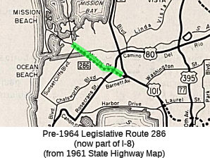
In 1959, Chapter 1062 defined LRN 286 as “Sunset Cliffs Boulevard near Mission Bay southeasterly to [LRN 2]”. The 1963 state highway map shows LRN 286 running from Barnett and Pacific Highway along Midway Drive to Sunset Cliffs. This corresponds to today’s Sports Arena Drive and W Mission Bay Drive to Sea World Drive.
In 1963, Chapter 526 eliminated the "near Mission Bay southeasterly", but didn't take effect due to Chapter 385. Instead, the equivalent change was made to Route 109. The later 1963 wording change reflected a new adopted alignment of the LRN 286 freeway west of planned I-5 in San Diego that ran along the southern flank of the San Diego Flood Control Channel
This is the first segment of present-day I-8; it was Route 109 between 1963 and 1972. It runs from Sunset Cliffs Boulevard near Mission Bay to I-5.
© 1996-2024 Daniel P. Faigin.
Maintained by: Daniel P. Faigin
<webmaster@cahighways.org>.
 Route 285
 Route 287