
 California Highways:
Click here for a key to the symbols used. An explanation of acronyms may be found at the bottom of the page.
 Routing
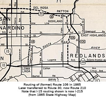 Nocurrent
routing.
Nocurrent
routing.
 Post 1964 Signage History
 As defined in 1963, Route 106 ran from Route 38 near Redlands to
Route 30 near Highland.
In 1965, Chapter 1371 amended the definition of the route, changing the
beginning of the route to Route 10: "Route 38 Route 10
near Redlands to Route 30 near Highland".
In 1972, the entire routing for Route 106 was transferred to Route 30 by Chapter 1216.
 Pre 1964 Signage History
The pre-1972 routing of Route 106 was part of LRN 190, defined in 1933.The full definition for LRN 190 was:
Segment 1 was initially not signed. By 1952, it was signed running between Los Angeles and the Big Bear resort (and included LRN 207, current Route 330). By 1953, Route 30 was being signed between San Dimas and Redlands, Route 30, located in San Bernardino County, followed Highland Avenue and City Creek Road, with a temporary western terminus as of 1953 in Upland at the junction of Euclid Avenue and Foothill Boulevard (US 66). The eastern end of Route 30 was at Running Springs on Route 18 west of Big Bear Lake. At the time, it was noted that eventually Route 30 would follow Highland Avenue all the way from its western terminus near Glendora, in Los Angeles County. That designation was pending until the portion of Highland Avenue between Glendora and Upland had been improved. At this time, it appears that although the N/S segment from Redlands to Highland was part of LRN 190, it was not signed as part of Route 30.
 The portion of LRN 190 that would become Route 106 was routed along Orange
Street between Highland and Redlands. The designation of Orange Street as
LRN 190 started as early as 1934. Between Highland Avenue and Orange
Street, the alignment of LRN 190 made numerous jogs, including Baseline
Street. By 1950, LRN 190 had been realigned to connect Highland
Avenue to Orange Street via Boulder Avenue. The portion between Route 30
(the LRN 207 Jct.) and Baseline Street became a four-lane divided highway
around 1955; the freeway alignment for this segment of LRN 190 was
announced in 1963. None of the maps appear to show this signed as Route 30.
The portion of LRN 190 that would become Route 106 was routed along Orange
Street between Highland and Redlands. The designation of Orange Street as
LRN 190 started as early as 1934. Between Highland Avenue and Orange
Street, the alignment of LRN 190 made numerous jogs, including Baseline
Street. By 1950, LRN 190 had been realigned to connect Highland
Avenue to Orange Street via Boulder Avenue. The portion between Route 30
(the LRN 207 Jct.) and Baseline Street became a four-lane divided highway
around 1955; the freeway alignment for this segment of LRN 190 was
announced in 1963. None of the maps appear to show this signed as Route 30.
(Source: Gribblenation Blog (Tom Fearer): Former California State Route 106)
Segment 2 was signed as Route 38.
Sign Route 106 was not defined as part of the initial state signage of routes in 1934. It is unclear what (if any) route was signed as Route 106 between 1934 and 1964.
 Interstate Submissions
In April 1958, the designation I-106 was proposed for the route from the eastern terminus of the Santa Monica Freeway (I-10) with the Santa Ana Freeway (I-5) [i.e., the current US 101/I-5/I-10 junction) to the western terminus of the San Bernardino Freeway (I-10) with the Golden State Freeway (I-5). This designation was not approved (although AASHTO did seem to like the loop idea) in favor of distinct designations for the US 101 portion (I-105) and the I-10 portion (I-110). In 1968, both the I-105 and I-110 designations were dropped, with the segments going back to US 101 and I-10, respectively.
 Other WWW Links
 Pre-1964 Legislative Route
In 1933, Chapter 767 defined the segment from "[LRN 14] near Hercules to the Walnut Creek-Antioch Road" as a state highway. In 1935, this was codified as LRN 106 in the highway code with the following routing:
In 1957, Chapter 36 changed LRN 14 to LRN 7, and clarified the terminus as being "north of Concord"
This is the route that runs from US 40 (now I-80) near Hercules to the Route 4/Route 24 junction N of Concord. This is signed as part of Route 4.
© 1996-2020 Daniel P. Faigin.
Maintained by: Daniel P. Faigin
<webmaster@cahighways.org>.
 Route 105
 Route 107