
 California Highways:
Click here for a key to the symbols used. An explanation of acronyms may be found at the bottom of the page.
 Routing
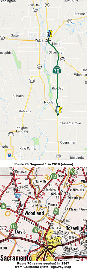 Route 99 near Catlett Road to Route 20 in Marysville.
 Post 1964 Signage History
In 1963, Route 70 was defined to run from Route 99 near Catlett Road to Route 395 near Hallelujah Junction via Quincy and Beckwourth Pass.
In 1986, Chapter 928 split the route into the current two segments: (a) Route 99 near Catlett Road to Route 20 in Marysville. (b) Route 20 in Marysville to Route 395 near Hallelujah Junction via Quincy and Beckwourth Pass. The portion in Marysville became part of Route 20.
The segment from Route 99 in Sacramento to the Route 70/Route 99 split is cosigned as Route 70/Route 99, although it is legislatively Route 99.
Some chronological notes:
Note that the original plans were for there to be an "East Valley"
corridor, consisting of Route 99 from I-5 north to Route 70, Route 70
north to Route 149, all of Route 149, and Route 99 north through Chico
probably reconnecting to I-5 (although plans north of Chico were shelved
in the 1990s). This was for a Midwest-style expressway with freeway
segments through the significant towns and interchanges at major
intersecting highways. This would have included a freeway bypass of
Marysville, the site of the last in-town surface street routing.
Unfortunately only the segments at the ends of the corridor—I-5 to
Olivehurst and Oroville to just north of Chico—were completed as
planned; everything else was cut back to conventional 4-lane commercial
standards (although a largely at-grade bypass of Marysville via the
Feather River berm and making use of the present Yuba River Route 70
bridge is under study as of 2018) due to lack of the funding needed to
acquire significant property between Marysville and Oroville for even an
expressway upgrade.
(Source: Scott Parker (SParker) on AAroads, 3/28/2018)
 Pre 1964 Signage History
In the 1934 definition of state highways, Sign Route 70 was not defined. In 1936, By 1936, US 70 was defined (see below) and precluded any use of Sign Route 70 until the great renumbering. In the 1964 Great Renumbering, the US 70 corridor became I-10, and Sign Route 24 became Route 70.
Post-1964 State Route 70: Route 99 to US 395
Before 1964, this was Sign Route 24. In 1934, Sign Route 24 was signed along the route from Woodland at Jct. US 99 to Jct. Route 7 (now US 395) near Reno Junction, via Oroville and Quincy (Reno Junction was likely the former name of what is now Hallelujah Junction, Reno Junction having replaced Chats). It appears it was extended, perhaps in 1936, to eventually have the route from US 40 in Oakland to US 395 near Reno Junction. See the page on Route 24 for the portion SW of Woodland. In Woodland, Route 24 diverged from Route 16 and continued N to Yuba City/Marysville along LRN 87. It was cosigned with US 40A, and this segment is now part of Route 113.
The pre-1951 routing of Route 24 between Sacramento and the current Route 70/Route 99 split was cosigned with US 99E, and likely ran along LRN 50. A 1969 map shows a different routing (cosigned with Route 99), along Jibboom Street, Garden Highway and El Centro Road. Note that the segment from Route 99 to Route 65 was not signed state highway until the move of Route 24 from the westerly (Woodland) route to the El Centro Avenue route in the 1950s. The portion of El Centro Road S of I-80 was still in existence as of 1995, but has since been replaced by residential streets.
Webster Street Bridge ⇒ Jibboon Street Bridge
The Webster Street Bridge structure across the Oakland
Estuary was erected in January 1926, a component of the Webster Street
Bridge between Oakland and Alameda. This structure replaced a similar
Pratt Truss swing structure that had been damaged by a ship impact in late
1925. The prior Pratt Truss at Oakland Estuary and the rest of the Webster
Street Bridge was constructed in 1898.
(Source: Gribblenation Blog (Tom Fearer), "The Jibboom Street Bridge (former California State Routes 24, 70 and 99 at the American River)", 10/30/2025)
Before the Posey and Webster tubes were built, there
were two small swing bridges between Oakland and Alameda for trains and
automobile traffic. After the turn of the century, these bridges were
struggling to bear the increase in commercial rail traffic and
encountering conflicts with ships. Located on Webster and Alice streets,
they opened 12 times a day in 1900. By 1906 that number had increased to
60. The Webster bridge was later incorporated into Sacramento’s
Jibboom Street Bridge (which was part of Sign Route 24). Built in 1928,
the Posey Tube solved that problem. Engineered by George Posey, the Posey
Tube was the widest in the world and it was built using an innovative
method. Most tunnels back then were constructed from a steel shell later
filled with concrete. To build the Posey Tube, construction crews floated
concrete tunnel pieces on a barge in the estuary to precise locations
before sinking and connecting them. Only London, New York, and
Philadelphia had large tunnels built this way back then. The portals were
designed by architect Henry Meyers, who’s known for designing
Highland Hospital, the Veterans Memorial Building, and the Caldecott
Tunnel as well. The quintessential Art Deco Oakland portal structure was
kind of an influencer of this area. The parallel Webster Street Tube
wasn’t built until the 1960s. The construction alleviated traffic in
the Posey Tube, which used to carry cars in both directions. Now Posey
goes from Alameda to Oakland, and Webster takes Oakland traffic into
Alameda.
(Source: Oaklandside, 7/24/2024)
In October 1928, the Posey Tube (future Route 260)
would open at Oakland Estuary as a replacement for the bridges located at
Webster Street and Harrison Street. The Pratt Truss part of the structure
was hauled via barge to Antioch, where it would remain until was purchased
by Sacamento County. During August 1929, Sacramento County contracted to
have the Webster Street Bridge moved to the American River. The structure
would be hauled through the Sacramento River Delta to the confluence of
the American River and Sacramento River during March 1930. The structure
would open to traffic during 1931 as an extension of Jibboom Street out of
the city of Sacramento. The Jibbom Street Bridge structure connected
Jibboom Street in Sacramento to Garden Highway north of the American
River.
(Source: Gribblenation Blog (Tom Fearer), "The Jibboom Street Bridge (former California State Routes 24, 70 and 99 at the American River)", 10/30/2025)
In 1935, the Jibboom Street Overhead was announced as a
recommended project. The proposed span would serve as a connection between
Jibboom Street and the I Street Bridge. Concepts of the Jibboom Street
Overhead noted that the project was planned as a Federal cooperative and
included a replacement for the original eastern approach to the I Street
Bridge. The original eastern approach landed at I Street just west of 2nd
Street. The new approach was planned to be elongated towards 3rd
Street. Jibboom Street originally connected to 2nd Street via
an at-grade crossing of the Southern Pacific Railroad. The Jibboom Street
Overhead and realigned eastern approach to the I Street Bridge were
dedicated by the Governor on October 1, 1937. In 1949, Legislative Chapter
1467 defined a duplicate LRN 207 as a new State Highway between Sacramento
and Marysville; this highway incorporated the Jibboom Street Overhead
branching north of the I Street Bridge. The corridor was originally
subject to the provisions of the Collier Burns Act of 1947 regarding
maintenance. The duplicate LRN 207 was renumbered as LRN 232 in 1951; the
Collier Burns Act provision the highway was subject to was removed in
1955. Sign Route 24 would continue to use the I Street Bridge until it was
realigned onto the Jibboom Street Bridge (LRN 232) in 1960.
(Source: Gribblenation Blog (Tom Fearer), "I Street Bridge (former California State Route 16 the Sacramento River)", 10/24/2025)
After 1964, Route 99 was defined as running through
Sacramento and Route 70 was originally signed to terminate at Capitol
Mall. Route 99 and Route 70 would initially use the eastern I Street
Bridge approach to reach the Jibboom Street Overhead. These were temporary
routings. In 1970, following the completion of I-5 north of downtown
Sacramento during the late 1960s, both Route 99 and Route 70 were moved to
I-5 and would multiplex the freeway.
(Source: Gribblenation Blog (Tom Fearer), "I Street Bridge (former California State Route 16 the Sacramento River)", 10/24/2025)
In 1969, the northern timber trestle on the Jibboom
Street Bridge was rebuilt as a concrete structure. This rendered the
structure no longer able to utilize turntable span. Access from the bridge
to Garden Highway was later severed to make way for additional parking in
Discovery Park (founded in 1960).
(Source: Gribblenation Blog (Tom Fearer), "The Jibboom Street Bridge (former California State Routes 24, 70 and 99 at the American River)", 10/30/2025)
 In 1954, Sign Route 24 was either co-signed or resigned as Alt US 40
(US 40A). The article announcing the designation indicated that existing
signs would be replaced by US 40 signs with the designation "Alt". The
article indicated that for the first 10 miles N, from US 40 in Solano
County, the new alternate route would be designated as US 99W and US 40A.
A new section of highway was being constructed to intersect with the
existing US 99W at the Woodland Wye. This would be the segment that is now
Route 113. In Woodland, US40A joined with the existing US 99W / Sign Route 24 to Yuba City; this is now Route 113. US 40A then followed Sign Route 24
(now Route 70) through Oroville and Quincy to US 395. Lastly, US 40A
followed US 395 S to Reno, which was the eastern terminus of US 40A. The
goal here was to provide an alternate route across the Sierras when Donner
Pass was closed.
In 1954, Sign Route 24 was either co-signed or resigned as Alt US 40
(US 40A). The article announcing the designation indicated that existing
signs would be replaced by US 40 signs with the designation "Alt". The
article indicated that for the first 10 miles N, from US 40 in Solano
County, the new alternate route would be designated as US 99W and US 40A.
A new section of highway was being constructed to intersect with the
existing US 99W at the Woodland Wye. This would be the segment that is now
Route 113. In Woodland, US40A joined with the existing US 99W / Sign Route 24 to Yuba City; this is now Route 113. US 40A then followed Sign Route 24
(now Route 70) through Oroville and Quincy to US 395. Lastly, US 40A
followed US 395 S to Reno, which was the eastern terminus of US 40A. The
goal here was to provide an alternate route across the Sierras when Donner
Pass was closed.
(Source: Roseville Press-Tribune 3/23/1954 via Joel Windmiller
(email), 11/12/2023)
Around 1960 the routing for signed Route 24 changed to a new routing along LRN 232, which used Jiboom Street and El Centro Street. This routing used the original Jiboom Street bridge over the American River and Main Drainage Canal. The Gribblenation Blog, "Highways in and around Old Sacramento; US 40, US 99W, CA 16, CA 24, CA 70, CA 99, CA 275, and more" provides a detailed history of the various highways (US 40, US 99, Route 16, Route 24, Route 70, Route 99, Route 275, Route 51, I-5, and I-80 in the Old Sac area. The portion of this route between Route 99 and Route 65 was LRN 232, defined in 1949.
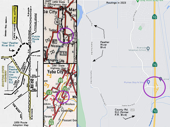 In 1959, the CHC adopted a routing for a connection between the "future Route 232 (LRN 232) freeway"
(today's Route 70 freeway routing) and the existing Route 232 highway
(Feather River Blvd) near Rio Oso. This connector swings W from the
adopted freeway route to join Feather River Blvd about a mile to the west.
It is hard to see today, because although Feather River Blvd was "new"
Route 24 (and later Route 70) at the time, it has since been relinquished
by the state and downgraded to a county road. The plans called for the
building of a two-lane bridge over the Bear River, upstream from the
existing bridge. This is part of the first stage of construction of the
new Route 70 freeway. The article indicated that when the LRN 232 freeway
(today's Route 70) was extended to US 99E (Route 99) in Marysville, this
connection would be incorporated into the Bear River interchange, and used
as a county road connection (as LRN 232 would move off Feather River
Blvd). However, in 1959, Feather River Blvd was new Route 24 headed north
on El Centro Road from the Sacramento River. Old Route 24 resigned the Alt
US 40 1955-64 alignment (current 113) from Woodland, which headed north at
Tudor at the current junction of Route 99 and Route 113 then headed north
into Yuba City. In this area for a small period of time (i.e., from 1964
until I-5 was completed and US 99 signs came down), California had both US 99 and California Route 99, but not on the same stretch of highway,
although the "official" (legislative) route was the one with the state
shield.
In 1959, the CHC adopted a routing for a connection between the "future Route 232 (LRN 232) freeway"
(today's Route 70 freeway routing) and the existing Route 232 highway
(Feather River Blvd) near Rio Oso. This connector swings W from the
adopted freeway route to join Feather River Blvd about a mile to the west.
It is hard to see today, because although Feather River Blvd was "new"
Route 24 (and later Route 70) at the time, it has since been relinquished
by the state and downgraded to a county road. The plans called for the
building of a two-lane bridge over the Bear River, upstream from the
existing bridge. This is part of the first stage of construction of the
new Route 70 freeway. The article indicated that when the LRN 232 freeway
(today's Route 70) was extended to US 99E (Route 99) in Marysville, this
connection would be incorporated into the Bear River interchange, and used
as a county road connection (as LRN 232 would move off Feather River
Blvd). However, in 1959, Feather River Blvd was new Route 24 headed north
on El Centro Road from the Sacramento River. Old Route 24 resigned the Alt
US 40 1955-64 alignment (current 113) from Woodland, which headed north at
Tudor at the current junction of Route 99 and Route 113 then headed north
into Yuba City. In this area for a small period of time (i.e., from 1964
until I-5 was completed and US 99 signs came down), California had both US 99 and California Route 99, but not on the same stretch of highway,
although the "official" (legislative) route was the one with the state
shield.
(Source: 1959 news clipping via Joel Windmiller, 1/27/2023)
From Route 65 near Marysville to Marysville, the current routing was part of LRN 3 (1910).
Tom Fearer, in a discussion on AARoads in June-July 2017, provides more history of Route 70: Route 70 from Oroville along the Feather River Highway to Quincy has some interesting history in terms of route numbering and alignments. Originally the Feather River Highway was part of Route 24, as seen on the 1938 State Highway Map. Prior to the construction of Oroville Dam the Feather River Highway was substantially different. East out of Oroville, Route 24 took what is now Oroville Dam Blvd/County Route B2 to the approximate location of Oroville Dam where it would have crossed the Feather River. Route 24 followed the west bank of the North Fork Feather River where it would have joined the modern alignment of Route 70 via Dark Canyon Road. The 1935 County Road Map shows the older alignment. In 1955, the Feather River Highway was renumbered as US 40A and really honestly it is kind of the perfect alternate to even Donner Summit, much less Donner Pass. By 1958 the newly adopted planned alignment of US 40A out of Oroville appears to the west of the highway to make way for the Oroville Dam project. By 1963, US 40A is shifted onto the new alignment north of the Feather River Highway. By 1965, State Highway Maps show the Feather River Highway renumbered to Route 70.
1936-1964 US 70: Los Angeles to Arizona
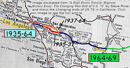 Before the 1964 renumbering, "Route 70" referred to
US 70. US 70 ran from Los Angeles to the Arizona border along the route
that approximates the post-1964 I-10. US 70 always ran co-signed within
California, either with US 60, US 99, or both. The original route was
generally US 60, as the US 60 signage dates back to 1926; US 99 primarily
to 1926 but some was after 1934; and US 70 was added in 1935. US 60/US 70
began in downtown Los Angeles, followed Ramona, Garvey-Holt Blvd, and Holt
Street into Pomona. In Pomona, the routing for US 60 turned on Garey and
ran to S to Mission, where US 60 continued E to Riverside and Beaumont. US 70 initially shared that US 60 routing; in 1938, the designation of US 70
was moved N to the current LRN 26 routing between Pomona and San
Bernardino, cosigned with US 99. In 1941, the transition of US 60 from LRN 26 on Holt to LRN 19 on Mission, previously along Garey, moved to the
current Route 71 diagonal routing from Arroyo to Mission; at the same
time, the transition of US 70 moved from a jog along a perpendicular
segment of Holt to the diagonal from Arroyo to Holt. Between Pomona and
Beaumont, US 60 (and US 70, before 1938) ran along Mission Blvd to
continue into Riverside, and then NE to Beaumont, where it rejoined US 99
/ US 70 (after 1938) and continued east. The co-signage with US 99
continued to Indio, where US 99 left the cosigned US 60 / US 70 and
continued S along the Salton Sea to meet US 80. Note that US 99 was
originally along the LRN 9 routing, shared with US 66; in 1934, US 99 was
moved off the LRN 9 (Foothill/US 66) routing, and moved to the LRN 26
routing (current I-10) into Los Angeles. Note that, at times, this was a
tri-plex routing (US 70 / US 60 / US 99) between Los Angeles and Pomona,
and between Beaumont and Indio.
Before the 1964 renumbering, "Route 70" referred to
US 70. US 70 ran from Los Angeles to the Arizona border along the route
that approximates the post-1964 I-10. US 70 always ran co-signed within
California, either with US 60, US 99, or both. The original route was
generally US 60, as the US 60 signage dates back to 1926; US 99 primarily
to 1926 but some was after 1934; and US 70 was added in 1935. US 60/US 70
began in downtown Los Angeles, followed Ramona, Garvey-Holt Blvd, and Holt
Street into Pomona. In Pomona, the routing for US 60 turned on Garey and
ran to S to Mission, where US 60 continued E to Riverside and Beaumont. US 70 initially shared that US 60 routing; in 1938, the designation of US 70
was moved N to the current LRN 26 routing between Pomona and San
Bernardino, cosigned with US 99. In 1941, the transition of US 60 from LRN 26 on Holt to LRN 19 on Mission, previously along Garey, moved to the
current Route 71 diagonal routing from Arroyo to Mission; at the same
time, the transition of US 70 moved from a jog along a perpendicular
segment of Holt to the diagonal from Arroyo to Holt. Between Pomona and
Beaumont, US 60 (and US 70, before 1938) ran along Mission Blvd to
continue into Riverside, and then NE to Beaumont, where it rejoined US 99
/ US 70 (after 1938) and continued east. The co-signage with US 99
continued to Indio, where US 99 left the cosigned US 60 / US 70 and
continued S along the Salton Sea to meet US 80. Note that US 99 was
originally along the LRN 9 routing, shared with US 66; in 1934, US 99 was
moved off the LRN 9 (Foothill/US 66) routing, and moved to the LRN 26
routing (current I-10) into Los Angeles. Note that, at times, this was a
tri-plex routing (US 70 / US 60 / US 99) between Los Angeles and Pomona,
and between Beaumont and Indio.
(Image source: "A High Plains Traveler Highway History Essay: The Changing West End of U.S. 70", 1/10/2023)
 This segment was made up of four distinct parts:
For an exploration of the western end of US 70, see A High Plains Traveler Highway History Essay: The Changing West End of U.S. 70 (Steve Riner), 1/10/2023.
US Highway and Interstate Numberings
As originally envisioned in the early drafts of US Route System. what became US 66 in California was intended to be US 60.
The designation of the Chicago-Los Angeles corridor was intended to carry
a X0 route number given it was to denote a major east/west US Route.
Ultimately the State of Kentucky petitioned to have a X0 US Route, and the
Chicago-Los Angeles corridor became US 66 in the finalized US Route System
created by the American Association of State Highway Officials (AASHO)
during November 1926. The X0 route in Kentucky, US 60, would rapidly be
extended after the US Route System was created and would come into play in
California during the early 1930s. A letter from the AASHO Executive
Secretary to the California State Highway Engineer dated Marth 30, 1931,
noted US 60 had been tentatively approved to be extended to California
during the AASHO Executive Committee on May 26, 1930. The approval of US 60 being extended to California carried the stipulation that the Colorado
River Bridge in Blythe be purchased by the California Division of Highways
and Arizona State Road Department. The letter noted California and Arizona
had taken steps through their respective legislatures to purchase the
Colorado River Bridge and the terminus of US 60 would be at an undisclosed
location in Los Angeles.
(Source: Gribblenation Blog (Tom Fearer), "Interstate 10 in the Sonoran Desert between the Colorado River and Coachella Valley", 10/14/2023)
The California State Highway Engineer submitted a
recommended routing of US 60 to the AASHO Executive Secretary on September
8, 1931. The route description of US 60 show as ending in Los Angeles by
way of Pomona at an undisclosed terminus. The routing of US 60 defined it
as entering Coachella Valley via LRN 64 through Box Canyon to Mecca
towards Coachella. From Coachella US 60 joined US 99/LRN 26 passing
through Coachella Valley towards San Gorgonio Pass. A September 1934
exchange of letters between the California State Highway Engineer and
AASHO acknowledged US 70 had been extended into California with an
endpoint following US 60 into downtown Los Angeles. The routing definition
of US 70 indicated it would multiplex US 99/US 60 east from downtown Los
Angeles to Pomona and onwards multiplexed with US 60 east to Beaumont and
US 99/US 60 through San Gorgonio Pass and Coachella Valley to LRN 64 near
Coachella. From Coachella US 70 followed US 60 via LRN 64 to the Arizona
State Line.
(Source: Gribblenation Blog (Tom Fearer), "Interstate 10 in the Sonoran Desert between the Colorado River and Coachella Valley", 10/14/2023)
The truncation of US 99 from Calexico to the junction
of the Golden State Freeway and San Bernardino Freeway in Los Angeles was
approved by the AASHO Executive Committee on June 19, 1963. US 70 was
truncated from Los Angeles to US 95 in Blythe by AASHO on August 26, 1963.
LRN 64 was dropped as part of the 1964 State Highway Renumbering. The
AASHO Executive Committee approved US 60 to be truncated from downtown Los
Angeles to US 95 in Blythe on October 2, 1965. On June 24, 1969, AASHO
approved an Arizona Highway Department request to truncate US 70 from the
California State Line to Globe, Arizona. US Route 60 was officially
deleted in California by AASHTO during their November 1982 meeting, with a
new ending at I-10 near Brenda, Arizona.
(Source: Gribblenation Blog (Tom Fearer), "Interstate 10 in the Sonoran Desert between the Colorado River and Coachella Valley", 10/14/2023)
Los Angeles and East Los Angeles to Pomona
In 1926, when the US highway system was commissioned,
the only US highway that transited downtown Los Angeles was US 101. Both
US 66 and US 99 went through Pasadena, although there was an effort to
bring US 66 into downtown Los Angeles (as described on the US 66 page).
Note that as originally envisioned in the early drafts of US Route System,
what became US 66 in California was intended to be US 60. The designation
of the Chicago-Los Angeles corridor was intended to carry a x0
route number given it was to denote a major east/west US Route. Ultimately
the State of Kentucky petitioned to have a x0 US Route and the
Chicago-Los Angeles corridor became US 66 in the finalized US Route System
created by AASHO during November 1926. In the late 1920s, however, the
main E/W lateral from Los Angeles was LRN 9, running along Colorado and
Foothill E from Pasadena to San Bernardino.
(DPF map research; US 66 Information Source:
Gribblenation Blog (Tom Fearer), "Former US Route 60-70 on Jack Rabbit Trail", March 2022)
In 1931, LRN 26 was extended into downtown Los Angeles with the addition of a segment that ran from [LRN 26] near Colton via Pomona to Los Angeles. Specifically, segment (i) of Chapter 82 defined it as "[LRN 26] near Colton via Pomona to Los Angeles". The April 1931 CHPW also discussed the proposal for the route, which referred to it as "a highway from Los Angeles to a connection with [LRN 26] E of Colton". Note that the extension did not start in Los Angeles; rather, it started near the eastern border of Los Angeles (roughly where the current Route 710 freeway ends at Valley Blvd), near Atlantic (LRN 167) and Garvey. This is because, prior to 1933, the Division of Highways could not maintain highways within cities.
Work to extend US 60 into California started in 1931.
In March 1931 tentative approval to extend US 60 was received, with the
stipulation that the Colorado River Bridge in Blythe be purchased by the
California Division of Highways and Arizona State Road Department. The
approval indicated that California and Arizona had taken steps through
their respective legislatures to purchase the Colorado River Bridge and
the terminus of US 60 was to be at an undisclosed location in Los Angeles.
The purchase happened in April 1931, and the state submitted a recommended
routing for US 60 to AASHO in September 1931. The route description showed
US 60 as ending in Los Angeles by way of Pomona. According to Scott Parker
on AARoads, "ACSC originally signed US 60 over Main St., originally from 7th
Street downtown, but later from Sunset Blvd. north of the Civic Center. US 66 was at that time (pre-1935) on Broadway, a couple of blocks west, so US 66 and US 60 paralleled each other—one (US 66) on a state-maintained
route (LRN 165) and the other with ACSC-erected US 60 signage on a
non-state route, which curved east with Main St. and segued (with US 99
past Daly St.) onto Valley Blvd., which was state-maintained east of the
L.A. city line at Eastern Ave. (LRN 77)." Scott's recollections are a bit
imprecise, as prior to 1934, US 99 shared a routing with US 66 along LRN 9. In any case, by 1932, US 60 had been extended to Los Angeles.
(Reference: Scott Parker (Sparker) on AARoad, "Re: US 66 1935 alignment via Eagle Rock pre-1936 via Royal Oaks Ave in Monrovia?", 5/20/2019)
Note: It does appear that Valley Blvd was the major thoroughfare between Los Angeles and points E prior to 1934, potentially competing with US 66, and with the smaller possibility that it was signed, for a time, as US 60. Valley Blvd did not end at Garey and Eastern; it continued to the S, going around the San Jose Hills into Pomona, where it split into Holt and 5th Street. Holt, as noted below, was part of LRN 26; 5th Street in Pomona (later Mission Blvd) was LRN 19. LRN 19 was later extended W along Valley Blvd to Brea Canyon (and continued S down Brea Canyon). The route of Valley Blvd approximated the eventual route of LRN 172 (Pomona Freeway, Route 60), although Valley Blvd S of Garey was never in the state highway system. The state highway maps, prior to the mid-1930s, did not identify the US highways clearly.
In 1933, when the Division of Highways gained the ability to maintain highways within cities, the LRN 26 was extended again, now running from "Los Angeles (Aliso Street) to [LRN 26] near Monterey Park via Ramona Blvd", which completed LRN 26 into downtown Los Angeles. This specification was for the eventual Ramona Parkway that became the San Bernardino Freeway (I-10).
Prior to 1935, US 60 followed an interim alignment from
downtown Los Angeles eastward following Macy Street, Mission Road,
Alhambra Avenue and Valley Boulevard towards Pomona. In fact, it appears
that US 60 continued along Valley until it intersected Garvey, even though
the "official" LRN 26 routing was along Garvey from Eastern. This was
likely to avoid a jog from Valley down Eastern. LRN 26, as the planned
Ramona Parkway, was under construction W of Atlantic Blvd (LRN 167). Maps
of the time show LRN 26 starting at Garvey and continuing E. The planned
Ramona Parkway was shown on maps as a dotted line connecting Macy Street
directly to Garvey Avenue. The Los Angeles-Pomona Arterial,
which was to follow what would become Ramona Boulevard, ran from Aliso
Street and Mission Street in downtown Los Angeles to the city limits of
Pomona. Construction was started in 1932. Ramona Boulevard along with
improvements to Garvey Avenue was dedicated on May 25, 1935.
(Source: Gribblenation Blog (Tom Fearer), "Interstate 10S and the original Interstate 110 in California", March 2024; Gibblenation Blog (Tom Fearer), "Former US Route 60 and US Route 70 in the Los Angeles-Pomona corridor", March 2022)
The Ramona Expressway portion of I-10 started its
development shortly after the US Highway system was adopted in 1926. At
this time, California began development of US 99. However, in 1926, US 99
was still designated to run along LRN 9 (US 66) through Pasadena. The
desire was to eventually have the US 99 run directly into downtown Los
Angeles. In Monterey Park, Garvey Avenue was designated as part of future
US 99. However, west of Atlantic Boulevard, the roadway ended. The
six-mile gap would be filled by a new roadway that would connect Garvey
Avenue near Atlantic Boulevard with Aliso Street at Mission Road to be
named Ramona Boulevard. Ramona Boulevard was along terrain that was
suitable for grade separations, with the Pacific Electric Railroad tracks
to the north and a hillside to the south. In order to accommodate the new
highway, six bridges that already spanned the tracks were extended or
reconstructed and two new grade separations were constructed near Monterey
Pass Road. Near the west end of the project, the Macy Street (now Cesar E.
Chavez Avenue) bridge, which had been built in 1910, provided another
grade separation over the tracks and could accommodate a roadway without
reconstruction. Thus, there were nine bridges in all with no at-grade
crossings and virtually no local property access. Once completed, LRN 26
was officially extended to Los Angeles, and arrangements were made to
resign it was US 99. Ramona Boulevard was opened to traffic on April 20,
1935 and was called an “airline” route by the State because
motorists could “fly” without intersectional conflict at 50
miles per hour. In 1944, Aliso Street, the westerly extension of Ramona
Boulevard was widened and reconstructed. This project, which was
undertaken by the City, included a grade separation at Mission Road. In
coordination with this project, the State widened Ramona Boulevard
easterly to the East City Limit and constructed a four-foot wide median.
Upon the completion of these projects, Ramona Boulevard was renamed Ramona
Parkway. In 1954, shortly after Ramona Parkway was extended easterly of
the City, it was renamed the San Bernardino Freeway. In 1970, most of the
1935 and 1944 improvements were demolished to make way for the San
Bernardino Freeway and Express Busway.
(The historical information above on the Ramona
Expressway was derived from "Transportation Topics and Tales: Milestones
in Transportation History in Southern California" by John E. Fisher,
P.E. PTOE, available at http://ladot.lacity.org/pdf/PDF100.pdf)
Leaving downtown LA in City Terrace, LRN 26 was called
Ramona Boulevard before it merged with Garvey Avenue. East of Monterey
Park, the route was a straight line — sometimes called an “air
line” — to the San Jose Hills and Pomona’s Holt Avenue.
A good share of it today lies under I-10. The main remnant of the route is
on Garvey between I-710 and where it merges into I-10 on the east end of
El Monte. A few links of frontage road along I-10 in Covina and West
Covina are still called Garvey Avenue, and there are still some small
segments of Ramona Blvd. A small portion of Holt Avenue exists in Covina,
although it has no connection with Pomona’s Holt and was not part of
LRN 26. The route itself was adopted by the state in 1931. The first
stretch of the new highway construction for the project was from Barranca
Street in West Covina, over the San Jose Hills through W.J.
Kellogg’s ranch along Arroyo (the future Cal Poly Pomona) to Pomona.
News accounts said the entire paved route would finally be ready for
travel on April 4, 1935, though some portions of it had opened earlier.
However, the Pomona Progress-Bulletin said on April 8 that heavy rains
delayed completing the work, and the full route didn’t open for
another few days. The article also said that the state had approved a
$12,000 contract to plant 25,000 ground-cover plants as well as two dozen
types of trees and shrubs along the highway. The new Pomona-LA road helped
spawn additional construction in the Inland Empire. Improvement programs
were begun on segments of Holt in Pomona and A Street in Ontario and
farther east when the route became Valley Boulevard in Fontana.
(Source: Daily Bulletin, 10/7/2019)
With the completion of the Ramona Parkway, LRN 26 was complete, and US 99 / US 60 was relocated to the Ramona Parkway / Garvey Routing. What about the previous signed US 60 routing along Valley Blvd (also called Pomona Blvd) to Garvey? In 1935, Chapter 626 added the following as Section 603 with no LRN: “603. There is hereby added to the state highway system a new route or portion of route from the east city limits of Los Angeles on Valley Boulevard to [LRN 26] near El Monte via Valley Boulevard and Pomona Boulevard”. In 1937, Chapter 841 repealed Section 603, and added the segment to [LRN 77] as segment (a), making the original Pomona to San Diego segment of LRN 77 (which we'll run into again with the Pomona diagonal) as (b). Note that, post 1935, segment (a) of LRN 77 does not appear to have had a number, although some claim to have seen maps showing it as US 70, with US 60 / US 99 along the LRN 26 segment. State highway maps and USGS maps, however, show LRN 26 with the US 60 / US 70 / US 99 triplex.
Additionally, in September 1934, California received word that US 70 had been extended into California from New Mexico. The original routing (in California) was cosigned with US 60. When this happened, signage for US 70 was added to the US 60 / US 99 signage in this area. Note that, for a short time E of Pomona, US 70 followed the US 60 route through Riverside to Beaumont.
Construction of the "Eastern Gateway" in Los Angeles
started in 1941. This would serve as a freeway structure originating at
Aliso Street in Los Angeles, and would tie directly in with existing US 99/US 60/US 70/LRN 26 via Ramona Boulevard along with the planned Santa
Ana Parkway of US 101/LRN 2. The Eastern Gateway included construction of
the new Aliso Street Bridge. The Aliso Street Bridge opened to traffic in
1944, along with a temporary connection to Mission Street and US 99/US 60/US 70/LRN 26 on the existing Ramona Parkway. Part of the upcoming
project consisted of upgrading Ramona Boulevard to full freeway standards
to the eastern Los Angeles city limit. The Ramona Freeway became the San
Bernardino Freeway in 1955.
(Source: Gribblenation Blog (Tom Fearer), "Interstate 10S and the original Interstate 110 in California", March 2024)
The history of the East LA Interchange, where US 101, I-10, I-5, and Route 60 come together, is discussed with US 101.
According to a Thomas Brothers map, which predates the
Pomona Grade Separation and the new routing through the San Jose hills: US 60 / US 70 / US 99 entered from the west in El Monte along Garvey. At the
intersection with Pacific (which was a diagonal from Ramona/San Bernadino
Road, and was called Holt in Baldwin Park (later renamed Pacific)), Garvey
turned into Arroyo Avenue, turning back into Holt Ave briefly at the
eastern end of West Covina, before becoming Arroyo Ave again. Note that
the Holt name is confusing: It also applied to a portion of Rowland
Avenue, which turned into Pomona and Covina Road, which turned into Holt,
which intersected (you guessed it) Arroyo Ave in the San Jose hills (this
is now Covina Hills Road, which continues right to the edge of the current
freeway).
(Source: Thomas Bros. map of Pasadena, Alhambra, Pomona, South Pasadena, Ontario, San Gabriel, Arcadia, Azusa, Monrovia, Upland, San Marino, Altadena, Sierra Madre, El Monte, La Verne, Covina, Glendora, Claremont, Rosemead, San Dimas, Baldwin Park, Duarte, Temple City, Wilmar, West Covina, and vicinity, Circa 1940s (document is undated))
In terms of freeway construction: Conversion of US 99/US 60/US 70/LRN 26 to full freeway standards east from Los Angeles city
limit 1.8 miles to Helen Drive was completed by April 1951. Conversion to
Hellman Avenue in Alhambra was completed in late 1952. Construction of an
underpass of the Pacific Electric Railway along with an interchange at
Eastern Avenue was also completed in 1952. The segment of the Ramona
Freeway from Hellman Avenue to 8th Street (Alhambra) was
completed by 1953. By Fall 1953, the Ramona Freeway was upgraded to full
freeway standards between the Aliso Street Bridge and Sign Route 19/Rosemead Boulevard interchange. The route was extended to San Gabriel
Blvd by 1954.
(Source: Gribblenation Blog, "Former US Route 60 and US Route 70 in the Los Angeles-Pomona corridor", March 2022)
Pomona to Colton/San Bernardino and Redlands
As noted above, US 70 ran along the 1931 extension of LRN 26 from San Bernardino to Los Angeles. Prior to that extension, what was the route from Los Angeles to San Bernardino? The answer is that there wasn't one. US 99, as noted above, ran cosigned with US 66 into Pasadena along LRN 9 from San Bernardino.
Note: It does appear that Valley Blvd was the major thoroughfare between Los Angeles and points E prior to 1934, potentially competing with US 66, and with the smaller possibility that it was signed, for a short time, as US 60. Valley Blvd (nee Pomona Blvd) did not end at Garvey; it continued to the S, going around the San Jose Hills into Pomona. Originally, it just continued into Pomona as Pomona Blvd, with Holt to the N of the tracks, and 5th to the S of the tracks, and no clear transition. Eventually, it was (a) renamed Valley, and (b) reconfigured to split into Holt running N of the tracks, and Pomona, which by 1940 transitioned down Arroyo Ave/Pomona Grade Separation to 5th Street. Holt, as noted below, was part of LRN 26; 5th Street in Pomona (later Mission Blvd) was LRN 19. LRN 19 was later extended W along Valley Blvd (nee Pomona Blvd) to Brea Canyon (and continued S down Brea Canyon). The route of Valley Blvd approximated the eventual route of LRN 172 (Pomona Freeway, Route 60), although Valley Blvd S of Garey was never in the state highway system. The state highway maps, prior to the mid-1930s, did not identify the US highways clearly.
1931 was a big year. In 1931, LRN 26 was extended from San Bernardino to the eastern edge of Los Angeles, and LRN 19 was extended from its 1909 definition to run into Beaumont. LRN 19 was defined in 1909 to run from LRN 9 W of Claremont (US 66 / US 99) to Riverside, and the 1931 extension changed that to run to LRN 26 in Beaumont. 1931 also saw another segment added to LRN 19, running from Pomona to LRN 2 (US 101) near Santa Ana; this segment would eventually become Route 57 and part of Route 60. Lastly, 1931 saw the extension of US 60 into California. This extension ran along LRN 26 (Holt Avenue), turning onto LRN 19 at Garey, and continuing along LRN 19 down Garey to 5th Street; Garey continued S as LRN 77, which would eventually become Sign Route 71. LRN 19 then turned E and originally continued 5th Street and California Street, and then SE along Riverside Blvd (all of which, by the mid 1950s had become Mission Blvd, with some slight reroutings S of California Street and near the airport) to Mira Loma. Shortly after passing LRN 193 (Hamner Avenue (then Adams, now Milliken), it turned pure east at Eitiwanda, continuing along Riverside Drive (subsequently renamed Mission Blvd and then overlain with the Route 60 freeway). At that point, Riverside Blvd (Mission Blvd) continued into Riverside as Van Buren; remember, US 60 had turned onto Riverside Drive (Mission Blvd) continuing E. At what is now Country Village Road, US 60 turned off Riverside Drive (Mission Blvd) onto 7th Street into Riverside. Unsurprisingly, this is now all Mission Blvd into Riverside. In Riverside, LRN 19 transitioned onto Eighth Street (now University), meeting LRN 43 at Market Street; LRN 43 continued N into San Bernardino as Sign Route 18 (and later, US 91 and US 395). US 60 continued E along Eighth/University (adding a co-sign with US 395), continuing to Box Springs Road to Allesandro Avenue (now Sunnymead Blvd, some of which is buried under the US 395/Route 60 junction). US 395 then continued S along LRN 78, with LRN 19 continuing E along Allesandro/Sunnymead through the Moreno Valley Badlands, meeting LRN 26 in Beaumont.
In 1931, the LRN 26/LRN 19 routing was clearly US 60. US 99 is less clear. Prior to 1934, US 99 used a routing along LRN 9 into Los Angeles. This is confirmed by the inset on the 1930 state highway map, which shows US 99 in Pasadena together with US 66. That map, however, doesn't show US 99 E of Los Angeles on the larger maps. It also clearly used LRN 26 into Beaumont from the east, simply because there was no other alternative. The 1934 state highway map, however, shows US 60 and US 99 using the LRN 19 alignment W of Beaumont, and still shows US 99 entering Pasadena along Foothill, co-signed with US 66. Presumably, US 99 was co-signed with Sign Route 18 up LRN 43 into San Bernardino to pick up LRN 9, although there is a smaller possibility that it used LRN 19 (which, if one recalls, started at LRN 9, at the intersection of Garey and Foothill). However, by the 1936 state highway map, US 99 is shown on LRN 19 W of Beaumont, but entering Los Angeles along Garvey, LRN 26, with US 60 and US 70. However, the 1935 Division of Highways map of US and State Numbered highways shows US 99 using the LRN 26 routing from Beaumont into Los Angeles, and US 60 / US 70 sharing the LRN 19 routing between Beaumont and Pomona. By the 1938 map, however, things are clear again: US 70 and US 99 are along the LRN 26 routing, and US 60 is using LRN 19 between Beaumont and Pomona.
As noted above, in September 1934, California received word that US 70 had been extended into California from New Mexico. The original routing (in California) was cosigned with US 60. When this happened, signage for US 70 was added to the US 60 / US 99 signage in this area. The US 60 route along LRN 19 from Pomona to Riverside was co-signed with US 70 until around 1938; although it is possible that US 70 signage had moved to LRN 26 as early as 1936, as the maps are just not clear (and there are no USGS maps covering the 1930s).
The 1934 Division of Highways Map shows LRN 26
following Garvey Avenue from Monterey Park onto Garvey, Arroyo Avenue,
Holt Avenue, Colton Avenue, I Street (within Colton), Colton Avenue, E
Street (in San Bernardino, presumably the LRN 26 spur to San Bernardino,
presumably for US 99 continuity pre-1934), Colton Avenue and Orange Street
(Redlands) passing through El Monte, West Covina, Pomona, Ontario and
Colton east to Redlands.
(Source: Gribblenation Blog, "Former US Route 60 and US Route 70 in the Los Angeles-Pomona corridor", March 2022)
In 1939, details were announced regarding the Pomona
Grade Separation that would serve as an extension of LRN 77 and the new
split of US 60 from US 99/US 70/LRN 26. US 60 originally had split from US 99/US 70/LRN 26 via Garey Avenue south to 5th Street in
downtown Pomona. The Pomona Grade separation allowed US 60 follow LRN 77
to 5th Street via two railroad overpass structures. The Pomona
Grade Separation opened on March 19, 1940.
(Source: Gribblenation Blog, "Former US Route 60 and US Route 70 in the Los Angeles-Pomona corridor", March 2022)
By 1940, a short connecting segment—an extension of Arroyo Road—had been constructed between LRN 19 on 5th/Mission and LRN 26 on Holt. It appears to have been an extension of LRN 77, and included the eventual Temescal Freeway (now Route 71). This spur is currently Route 71 between I-10 and Route 60. By 1940, it appears to have been signed as part of US 60 / US 70 / US 99. LRN 26, at this time, ran along Garvey Ave and Arroyo Ave to meet Holt Avenue in Pomona (note: it appears that Holt originally met Arroyo at the base of the San Jose Hills: one turned R onto Holt, and then made a left where Holt met Valley (at the point Valley turned into Holt)—this road is now Ridgeway Street), and then along Holt, Colton Avenue, and Ocean Highway into Colton. Much of this has been subsumed under I-10, although portions of Garvey exists as frontage roads as far as Barranca in West Covina. Garvey turned into Arroyo at Barranca, and the Arroyo Avenue portion was mostly subsumed into I-10. Near the Pomona Grade Separation, US 60 / US 70 / US 99 veered S to Holt. The specific road is subsumed under Route 71. Note that a road called Ganesha came off of Arroyo just E of where LRN 26 veered off; that road today is Murchison Avenue and Fairplex Road, and it explains the naming of Ganesha High School. Additionally, the intersection of Murchison Avnue and Ridgeway is approximately what used to be Arroyo and Holt, although it was likely modified by freeway construction. East of the point where Pomona Blvd splits off of Valley Blvd, Holt has been renamed as an extension of Valley Blvd. Note that the split of Valley Blvd into Holt and 5th has been transformed by time: Valley now continues onto what was Holt, and the transition from Mission Blvd (nee 5th) to Valley Blvd has been lost with the construction of the Route 57 freeway (although maps do show that prior to the freeway, LRN 19 went along Pomona Blvd to the Pomona Grade Separation, down to Mission, and then to points E).
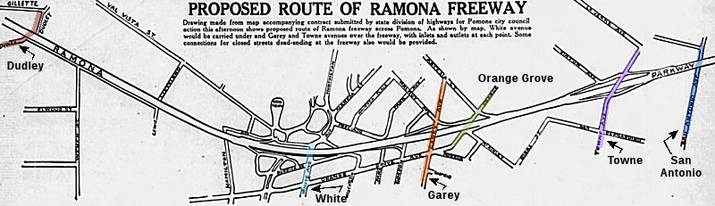 Planning for the freeway segment in Pomona began in the late 1940s. In September
1947, the Pomona City Council took action on the freeway agreement with
the state. The agreement covered closing numerous city streets, carrying
of three principal N-S routes across the freeway, and opening and
relocation of other city streets. The streets that would remain open and
cross the freeway were White, Garey, and Towne. There would also be a
crossing in S. Claremont at Alexander Avenue. Eventually, there would also
be crossings at Dudley, Fairplex, Orange Grove, and San Antonio. Although
the map shows a crossing at Hamilton, that appears to have never been
built.
Planning for the freeway segment in Pomona began in the late 1940s. In September
1947, the Pomona City Council took action on the freeway agreement with
the state. The agreement covered closing numerous city streets, carrying
of three principal N-S routes across the freeway, and opening and
relocation of other city streets. The streets that would remain open and
cross the freeway were White, Garey, and Towne. There would also be a
crossing in S. Claremont at Alexander Avenue. Eventually, there would also
be crossings at Dudley, Fairplex, Orange Grove, and San Antonio. Although
the map shows a crossing at Hamilton, that appears to have never been
built.
(Source: Pomona Progress Bulletin, 9/30/1947)
The first segment of the "Ramona Freeway" opened on
Nov. 16, 1954, with a segment running 13.4 miles from Kellogg Hill in
Pomona to Archibald Avenue in Ontario. The freeway to the west between El
Monte and Covina was still being built, and work hadn't even started east
of Ontario. The routing was contentious. Pomona fought the route for five
years, wanting it to go north around the San Jose Hills in the vicinity of
Arrow Highway. Ontario and Upland also battled over their part of the
highway, finally agreeing on a route that tight-roped their joint
boundary. Farther west, El Monte was involved in a bitter dispute over the
route that cut the city in half. As for the naming, "San Bernardino
Freeway" was bestowed on November 24, 1954, just eight days after the
opening ceremonies. Originally called the Ramona Freeway, Pomona interests
had pushed for the route to be named for their city, which it bisected.
Instead, the State Highway Commission announced the route would be known
as the San Bernardino Freeway, even though the completed freeway wouldn't
even go to downtown San Bernardino, unless you made a left turn on US 395
(now Route 15) just east of Colton. They suggested that the future
"foothills" route (I-210 Freeway) would be better named for San
Bernardino.
(Source: Inland Valley Daily Bulletin, date unknown as the original link no longer works)
E of what is now Fairplex, Valley Blvd turns back into Holt. LRN 26 continued Holt and Colton into San Bernardino. It appears the Holt became Valley at the SBD county line and A Street in Ontario, although today it remains Holt. Today, the route (as Business Route 10) remains Holt until it runs back into I-10 at the Ontario Airport. At this point, LRN 26 may have jogged on Archibald up to G Street/Colton Ave, which ran N of the current freeway; by the early 1950s, this had been reworked into a transition to Valley Blvd, which was subsumed under I-10. Colton Avenue was at the same lateral line as Inland Empire Blvd and Ontario Mills Parkway, but those appear to be newer roads on/near the same alignment. At Etiwanda Avenue, Valley Blvd (nee Colton Ave) resumes, where it continues E. Within Colton, it became I Street (Ocean to Ocean Highway), again, now Valley Blvd. to end shortly E of Mt Vernon (former LRN 31), where it is subsumed by I-10 again. Within Colton, The portion between Etiwanda and Calabash appears to be a 1953 extension of Colton, paralleling the replacement Valley Blvd Expressway, which became the freeway. LRN 26 picks up on the other side of the I-215 interchange as Redlands Blvd (nee Colton Ave). At Alabama St, LRN 26 originally followed Colton Street straight to the E, dropping down Orange Street to continue E on Central Ave (now Redlands), veering SE down Reservoir. By 1953, the routing had been changed to veer SE on a new roadway, now Redlands Blvd, which continued onto the former Central E of Orange Street to Reservoir.
In terms of freeway construction: Conversion to freeway
in Claremont, Pomona, and Ontario was completed by 1955. The freeway was
completed between San Dimas and Citrus Avenue in West Covina by 1956. By
1960, the now renamed San Bernardino featured continuous 60.2 miles
between the Santa Ana Freeway in Los Angeles and Riverside Freeway (US 395/US 91/LRN 43) in Colton. When the interchanges at Cherry Avenue and
Cedar Avenue were opened to traffic on US 99/US 70/LRN 26 on March 3,
1960, the last expressway segments of the San Bernardino Freeway closed
between Los Angeles and Colton.
(Source: Gribblenation Blog, "Former US Route 60 and US Route 70 in the Los Angeles-Pomona corridor", March 2022)
Colton/San Bernardino and Redlands to Beaumont
The section between Redlands and Beaumont was first signed as US 99; US 70 was added to the mix in 1938. This portion of LRN 26 was defined in 1916.
This segment ran along Central and Reservoir E out of Redlands. Reservoir Street was later renamed Roosevelt Road (by 1948), and by the late 1950s, it was Redlands Blvd (quite likely, after it was bypassed by the freeway). SE of Ford in S. Redlands, the current road has various names: Reservoir Road, Outer Hwy 10, Calimesa Blvd, Desert Lawn Dr. LRN 26 entered Beaumont along 6th Street, which is also the point where it merged/split with LRN 19, US 60. A portion is now Copper Drive and Roberts Road in Calimesa.
The highway in the Redlands to Beaumont corridor was
first graded in the 1920s, and paved by 1926.
(Source: Gribblenation Blog (Tom Fearer), "Former US Route 99-70 in Calimesa", April 2022)
In 1950, work had begun to expand US 99/US 70/LRN 26 in
Calimesa. Calimesa was the last section of US 99/US 70 between Los Angeles
and Palm Springs to be two-lanes wide. The expansion of US 99/US 70/LRN 26
was to a four-lane expressway over a 9.6-mile project zone, along a
completely new alignment detached from than existing Calimesa Boulevard.
This Calimesa expressway segment of US 99/US 70/LRN 26 opened to traffic
on May 21, 1951. Part of the new alignment of US 99/70/LRN 26 included a
new junction with US 60 on the outskirts of Beaumont.
(Source: Gribblenation Blog (Tom Fearer), "Former US Route 99-70 in Calimesa", April 2022)
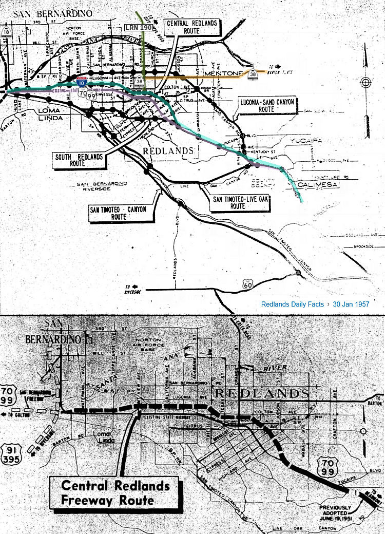 In 1957, there were five proposed freeway routings for
the segment from the junction with LRN 31 (Pre-1965 US 395/US 91 ⇒
Post-1964 I-215) near E Street W of Loma Linda and Live Oak Canyon near
Yucaipa. On the map shown, circles indicate traffic interchanges, and
squares indicate bridges. The map has been augmented to highlight the
state highway route existing at the time, as well as the final route
selected. Note that if the San Timoteo route (San Timoteo is now Oak
Valley Parkway) was selected, it would join US 60 (Jack Rabbit Trail) at a
point 4 mi W of Beaumont. The San Timoteo route and the South Redlands
route would follow the same line from E St to just E of Bryn Mawr.
Although the Live Oak Canyon connection was initially supported by the
City of Redlands, the state later downgraded that proposal, noting that it
would cost more to build than the amount of dollar benefits it would
return to motorists over a 20 year period. They rated the San Timoteo
route, with no Live Oak leg, as the better route.
In 1957, there were five proposed freeway routings for
the segment from the junction with LRN 31 (Pre-1965 US 395/US 91 ⇒
Post-1964 I-215) near E Street W of Loma Linda and Live Oak Canyon near
Yucaipa. On the map shown, circles indicate traffic interchanges, and
squares indicate bridges. The map has been augmented to highlight the
state highway route existing at the time, as well as the final route
selected. Note that if the San Timoteo route (San Timoteo is now Oak
Valley Parkway) was selected, it would join US 60 (Jack Rabbit Trail) at a
point 4 mi W of Beaumont. The San Timoteo route and the South Redlands
route would follow the same line from E St to just E of Bryn Mawr.
Although the Live Oak Canyon connection was initially supported by the
City of Redlands, the state later downgraded that proposal, noting that it
would cost more to build than the amount of dollar benefits it would
return to motorists over a 20 year period. They rated the San Timoteo
route, with no Live Oak leg, as the better route.
(Source: Redlands Daily Facts, 1/30/1957)
Later in 1957, it was reported that the Central
Redlands Route was adopted. Plans called for construction of a 4-lane
freeway, with provisions for 6-lanes. Initial cost would be $11.42
million.
(Source: Unspecified Newspaper, 1957, via Joel
Windmiller, 1/27/2023)
In 1958, design work began convert US 99/US 70/LRN 26
from Yucaipa Boulevard east through Calimesa to Beaumont to freeway
standards. The new interchange with Yucaipa Blvd was completed in 1959. By
1961, construction had started on the freeway bypass alignment of US 99/US 70/I-10/LRN 26 through Redlands.
(Source: Gribblenation Blog (Tom Fearer), "Former US Route 99-70 in Calimesa", April 2022)
In 1958, design work began convert US 99/US 70/LRN 26
from Yucaipa Boulevard east through Calimesa to Beaumont to freeway
standards. The new interchange with Yucaipa Blvd was completed in 1959. By
1961, construction had started on the freeway bypass alignment of US 99/US 70/I-10/LRN 26 through Redlands.
(Source: Gribblenation Blog (Tom Fearer), "Former US Route 99-70 in Calimesa", April 2022)
By March 1962, the new US 99/US 70/US 60/I-10/LRN 26
bypass of Beaumont and Banning opened. This bypass included a new
interchange between US 60/LRN 19 and US 99/US 70/I-10/LRN 26. Later that
year, the US 99/US 70/I-10/LRN 26 freeway bypass of Redlands opened. At
this point, only approximately 12 miles of existing US 99/US 70/I-10/LRN 26 through the Calimesa area were left in need of freeway conversion. This
conversion was completed by Summer 1965.
(Source: Gribblenation Blog (Tom Fearer), "Former US Route 99-70 in Calimesa", April 2022)
Beaumont and San Gorgonio to Indio
Between Beaumont and Indio, US 70 was also part of LRN 26. This portion of LRN 26 was defined in 1916. It was signed as US 99, US 60 (after 1931), and US 70 after 1938 from Beaumont to Indio.
The portion of the route from San Gorgonio Station (now
Beaumont) to Indio dates back to the Bradshaw Trail. The Bradshaw Trail
was a wagon road through the Sonoran Desert east to the Colorado River.
During the California Gold Rush the Bradshaw Trail was plotted through the
Sonoran Desert by William D. Bradshaw. The Bradshaw Trail despite its elongated path essentially was the forerunner of what would become modern I-10
from Palm Springs to the City of Blythe. During the 1916 Second State
Highway Bond Act LRN 26 was added to the State Highway System as a route
from San Bernardino southeast to El Centro. LRN 26 was essentially a
forerunner of what would become the earliest alignments of US 99.
(Source: Gribblenation Blog "Califoooornia! (Interstate 10 west from CA 86 through Coachella Valley and San Gorgonio Pass to CA 60 in the Moreno Valley Badlands)")
Through Beaumont, LRN 26 ran along 6th Street and Ramsey Street, and it continued as Ramsey Street into Banning. In Cabezon, LRN 26 used Main Street. Near Whitewater, it was what is now the Whitewater Cutoff, and in North Palm Springs, Garnet Road.
In 1933, a series of improvements to US 99/US 60/US 70/LRN 26 in Coachella Valley were completed. These improvements included
widening 14.5 miles of highway between Whitewater-Indio and the
elimination of 31 dips via bridging structures.
(Source: Gribblenation Blog (Tom Fearer), "Former US Route 99-60-70 in Indio and Coachella Valley", May 2022)
The 1923 Whitewater Bridge was constructed as part of
the construction of LRN 26, later US 60/US 99/US 70 and currently I-10
(although the 1923 bridge never saw the route as I-10). The 1923
Whitewater Bridge was host to several Auto Trails. The 1924 Rand McNally
Highway Map of California shows the Southern National Highway and the
Atlantic & Pacific Highway crossing the 1923 Whitewater Bridge. By
late 1926 the US Route System was approved which led to US 99 being
aligned over LRN 26 and the 1923 Whitewater Bridge. In 1932 US 60 was
extended into California which multiplexed US 99/LRN 26 from Mecca over
the 1923 Whitewater Bridge. US 99 and US 60 were joined by US 70 in 1934
when it was extended into California. As the 1930s and 1940s progressed
traffic increased on US 99/60/70. In the 1950s much of LRN 26 and US 99/60/70 in Coachella Valley was upgraded to an expressway more in line
with the present alignment of I-10. The July/August 1954 Department of
Public Works Guide discusses the progress of building US 99/60/70 in
Coachella Valley to an expressway. The replacement bridge was built in
1952, and currently along I-10 as RIV 27.69 (Bridges 56-0004L and
56-0004R). The original alignment of US 60 in this area is Whitewater
Cutoff Road, and the bridge is currently closed to automobile and
pedestrians.
(Source: Gribblenation Blog: Former US Routes 99/60/70 on the 1923 Whitewater Bridge)
Tom Fearer describes the 1935 routing as follows: From
the junction with Route 111/LRN 187 US 99/US 60/US 70/LRN 26 passed
through Garnet siding via what is now Garnet Avenue. From Garnet, US 99/US 60/US 70/LRN 26 followed what is now Varner Road to Edom. From Edom, US 99/US 60/US 70/LRN 26 largely followed Varner Road to a railroad crossing
near what is now Madison Street to Indio Boulevard towards downtown Indio.
US 99/US 60/US 70/LRN 26 originally passed through the downtown Indio
business district via Jackson Street (now Fargo Street), where it jogged
back to Indio Boulevard. From downtown Indio, US 99/US 60/US 70/LRN 26 ran
concurrent to Coachella. US 99 split via what is now Cesar Chavez Street
on LRN 26 towards El Centro, whereas US 60/US 70/Sign Route 111 followed
Grapefruit Boulevard on LRN 64 towards Mecca and Box Canyon. At 66th
Street, LRN 64 split off to the E, continuing to Box Canyon Road and
across Box Canyon. LRN 187 resumed its route as Sign Route 111 to El
Centro.
(Source: Gribblenation Blog (Tom Fearer), "Former US Route 99-60-70 in Indio and Coachella Valley", May 2022)
In 1935, the Indio-Cutoff opened and US 60/US 70 was
realigned onto the new spur of LRN 64. This opening was five months ahead
of schedule. The Indio-Cutoff was 9 miles shorter than the original
alignment of US 60/US 70 through Box Canyon. Despite Box Canyon no longer
being part of US 60/US 70, it remained under State maintenance and become
part of the post-1964 Route 195. Additionally, in 1937, a
realignment/widening of US 99/US 60/US 70/LRN 26 in downtown Indio
occurred. The realignment of US 99/US 60/US 70/LRN 26 in Indio began at
Oasis Street (4 blocks W of Jackson Street (now Fargo)) and extended to
the southern city limit. Lastly, in 1941, the new junction of US 99/US 60/US 70/LRN 26 with Sign Route 111/LRN 187 opened. The new "Palm Springs
Junction" featured channelized traffic that was carried via two-lanes in
each direction of travel on US 99/US 60/US 70/LRN 26. Previously US 99/US 60/US 70/LRN 26 intersected Route 111/LRN 187 at what is now Tipton Road.
(Source: Gribblenation Blog (Tom Fearer), "Former US Route 99-60-70 in Indio and Coachella Valley", May 2022)
The opening of the Indio-Cutoff, the 1937 realignment, and the Palm Springs Junction changed things. By 1943, Closer to Indio, Varner Road was still LRN 26 through Thousand Palms and Palm Desert. LRN 26 entered Indio through Jefferson Street and Indio Blvd; the diversion along Jackson/Fargo Street was gone, and Sign Route 111 joined LRN 26 at Indio Blvd. Sign Route 111 joined LRN 26 at the intersection with 46th Avenue (later Ave 46, and now "CA 111"); this is also the point where Sign Route 74 and the second segment of LRN 64 terminated . At Dillon Road, LRN 64 split off and carried US 60/US 70 to Arizona, with LRN 26 continuing down to the Salton Sea, Westmorland, and Brawley. Note that although Tamarack Road parallels I-10 near the Palm Springs Cutoff, it was never LRN 26.
Originally, LRN 26 split from LRN 187 at the Cesar Chavez (Harrison Street) / Grapefruit Blvd split, with US 99 continuing down LRN 26, and Sign Route 111 continuing along Grapefruit. This changed with the 1964 renumbering, when the portion of former US 99 between Route 111 to Palm Desert and the former US 99/Route 111 split became Route 111, and US 99 to El Centro became Route 86. At that time, the Salton Sea segment of Route 111 started at the split with Route 86 and ran to Route 78 near Brawley; and Route 86 ran I-8 (former US 80) near El Centro to I-10. Route 111 was shortened to start at Route 86 near Mecca in 1972. This reflected a rerouting of Route 86 off of the old US 99 Cesar Chavez/Harrison St alignment through Oasis onto a new expressway that ran S from 66th Avenue. Things changed more after the Route 86 Expressway was constructed between I-10 and Mecca. At that time, the Route 86 Expressway, former Route 86S, became Route 86. The previous routing of Route 86 along Indio Blvd and Grapefruit was relinquished to Indio (although it still had some Route 111 signage for continuity). Ave 66 (66th Ave) and the Box Canyon, Route 195, were legislatively deleted, although a portion was transferred in Mecca was transferred in 2014 to provide a connection between Route 86 and Route 111 along Ave 66 and Lincoln Street (due to the construction of the Ave 66 bypass).
By March 1941, LRN 26 between Beaumont and Banning had
been upgraded to a four-lane divided highway. Freeway conversion started
in the 1950s, with freeway route adoption or studies taking place in 1952
in Beaumont and Cabazon. The Beaumont Bypass opened in 1962; the freeway
through Cabazon was completed in 1964. Summer 1966 saw the freeway
completed to Route 111.
(Source: Gribblenation Blog (Tom Fearer), "Former US Routes 99-60-70 in San Gorgonio Pass (Beaumont, Banning and Cabazon)", April 2022)
In 1954, work was progressing on expanding US 99/US 60/US 70/LRN 26 to expressway standards in the Coachella Valley. The 1923
Whitewater River Bridge was bypassed by a new four-lane alignment of US 99/US 60/US 70/LRN 26 that year, and the ongoing expressway project
spanned 14.4 miles from west of Garnet to Thousand Palms (previously
Edom). By 1958, studies were starting for the full freeway conversion. By
1967, most of the freeway conversion had been completed to Indio. At that
time, there was a determined freeway routing that would bypass Indio and
connect with a planned freeway to Thermal. I-10 followed an interim
alignment through Indio from the Indio Rail Overhead along Indio Boulevard
and Dillon Road to the Indio-Cutoff. I-10 was ultimately completed in the
early 1970s; it was shown as completed by the 1975 state highway map.
(Source: Gribblenation Blog (Tom Fearer), "Former US Route 99-60-70 in Indio and Coachella Valley", May 2022)
Indio to the Arizona Border
By 1924, the stretch beween Mecca and the Arizona
Border was part of the Atlantic and Pacific Highway. This would become LRN 64. The general routing of LRN 64 was different from the Bradshaw Trail as
it followed Box Canyon, Chiriaco Summit and Chuckwalla Valley. 1924 saw
the start of work to modernize/grade LRN 64 (the Mecca-Blythe Highway).
Improvements were in the segment from Shavers Well in Box Canyon and
extending east to Blythe.
(Source: Gribblenation Blog "Califoooornia! (Interstate 10 west from CA 86 through Coachella Valley and San Gorgonio Pass to CA 60 in the Moreno Valley Badlands)"; Gribblenation Blog (Tom Fearer), "Interstate 10 in the Sonoran Desert between the Colorado River and Coachella Valley", 10/14/2023)
Before 1935, the alignment of US 60/US 70/LRN 64 east
from Mecca to the Arizona state line split from US 99 in Coachella. US 99
split via what is Cesar Chavez Street on LRN 26 towards El Centro, whereas
US 60/US 70 followed Grapefruit Boulevard on LRN 64 towards Mecca. At 66th
(now Ave 66), it turned E and into Box Canyon along Box Canyon Road. From
Box Canyon, US 60/US 70/LRN 64 continued east over Chiriaco Summit towards
Chuckwalla Valley. US 60/US 70/LRN 64 eastbound passed through Chuckwalla
Valley along what is now Chuckwalla Valley Road towards Blythe. Within
Blythe, US 60/US 70/LRN 64 followed Hobsonway to the Colorado River Bridge
at the Arizona state line.
(Source: Gribblenation Blog (Tom Fearer), "Interstate 10 in the Sonoran Desert between the Colorado River and Coachella Valley", 10/14/2023)
The 1934 State Highway Map shows a fully graded LRN 64
carrying US 60. The 1935 California Division of Highways Map of Riverside
County shows the entire routing of LRN 64 in far more detail. LRN 64/US 60/US 70 originally diverged significantly from I-10 using alignments on
Chuckwalla Valley Road and Box Canyon Road. A September 1934 Department of
Public Works Guide describes the construction of what was known as the
"Indio Cut-Off" route of US 60 bypassing Box Canyon Road. Chiraco Summit
at the time was referred to has "Shaver's Summit" and the Guide states
that Box Canyon Road was oiled in 1933. The Indio Cut-Off is described as
having a 6.3% grade and an anticipated opening of July 1935. By late 1935
the modern grade used by I-10 descending westward from Chiriaco Summit
into Coachella Valley in proximity to Coachella was completed. US 60/US 70
were moved to the new grade by 1936. By 1940 US 95 was routed into
California via what was Route 195. After US 95 was extended to California,
a second Route 195 was created along LRN 64 on Box Canyon Road. LRN 64 was
actually a split route carrying US 60/US 70 on the north segment and Route 195 on Box Canyon Road, according to the 1940 State Highway Map. By the
1966 State Highway Map edition the planned bypass of Chuckwalla Valley
Road appears. By the 1967 State Highway Map I-10 appears co-signed with US 60 from Coachella to Chiriaco Summit. By 1969, I-10 bypassed Chuckwalla
Valley and was nearly completed through the Sonoran Desert. West of
Chuckwalla Valley Road the former routing of US 60/US 70 in Desert Center
was on Ragsdale Road just north of I-10.
(Source: Gribblenation Blog Old US Route 60/70 through Hell (Chuckwall Valley Road and Ragsdale Road), Califoooornia! (Interstate 10 west from CA 86 through Coachella Valley and San Gorgonio Pass to CA 60 in the Moreno Valley Badlands))
Modern Dillon Road between Grapefruit Boulevard and
I-10 was once part of the Indio-Cutoff alignment of US 60 and US 70. In
1934, construction began on the Indio-Cutoff Spur of LRN 64. The
Indio-Cutoff was to serve as a new alignment of US 60/US 70 that would
enter Coachella Valley via Dillon Road and would provide a bypass to the
hazards of Box Canyon. The cutoff opened in 1935, and US 60/US 70 was
realigned onto the new spur of LRN 64. This was five months ahead of
schedule; and the new cutoff was 9 miles shorter than the original
alignment of US 60/US 70 through Box Canyon. Despite Box Canyon no longer
being part of US 60/US 70, it would remain under State maintenance and
become part of the second Route 195. The eastern end of the Indio-Cutoff
near Indio incorporated Dillon Road into its alignment.
(Source: Gribblenation Blog (Tom Fearer), "Dillon Road", 9/15/2023)
For those looking for old US 60/US 70 off of I-10, look for several small exits on I-10 between Indio and Blythe. There is a portion of US 60 between Corn Springs Rd. and Ford Dry Lake Rd.
The highway from Blythe to Needles was originally Sign
Route 195/LRN 146. The AASHO Executive Secretary advised the Highway
Engineers of California, Nevada, Oregon and Idaho in a letter dated July
7, 1939, that the AASHO Executive Committee approved the extension of US 95 to Blythe, California. US 95 absorbed the existing routing of Sign
Route 195/LRN 146 from the Nevada State Line south to US 60/US 70/LRN 64
at Hobsonway in Blythe. Upon the extension of US 95 into California the
original Sign Route 195 was deleted. The Sign Route 195 number was
reassigned to the former routing of US 60/US 70 via the spur of LRN 64 in
Box Canyon.
(Source: Gribblenation Blog (Tom Fearer), "Interstate 10 in the Sonoran Desert between the Colorado River and Coachella Valley", 10/14/2023)
In 1958, US 60/US 70/LRN 64 from Indio-Cactus City was
under study to expand to freeway standards. US 60/US 70/LRN 64 from Cactus
City east to the Arizona State Line had a freeway alignment adopted by the
California Highway Commission. US 70 was truncated from Los Angeles to US 95 in Blythe by the American Association of State Highway Officials on
August 26, 1963. The truncation of US 70 left only US 60 and temporary
I-10 as the only signed routes using the Indio stub of Dillon Road along
the Indio-Cutoff. LRN 26 would be dropped along with all the Legislative
Route Numbers as part of the 1964 State Highway Renumbering.
(Source: Gribblenation Blog (Tom Fearer), "Dillon Road", 9/15/2023)
The February/March 1928 California Highways &
Public Works featured the opening of the Colorado River Bridge
(Blythe-Ehrenburg Bridge) at the Arizona state line east of Blythe. The
Colorado River Bridge opened as a Riverside County owned tolled crossing
which replaced the existing ferry to Ehrenburg, Arizona.
(Source: Gribblenation Blog (Tom Fearer), "Interstate 10 in the Sonoran Desert between the Colorado River and Coachella Valley", 10/14/2023)
In Blythe, the first bridge to cross the Colorado replaced an existing cable ferry, established in 1870 between Ehrenberg AZ and Blythe CA. The new bridge, opened in 1928, was a toll bridge constructed by Riverside County, and was not part of the state highway system (although it was an extension of LRN 64). It had five steel truss spans each 190' long, for a total length of 950'. The roadbed was 20' wide, and it was 30' above the water. In 1931, the state purchased the toll bridge.
In 1961, the new Colorado River Bridge carrying US 60/US 70/US 95/I-10 into Arizona east of Blythe was completed.
Construction costs for the new Colorado River Bridge were shared by the
states of California and Arizona. The new span replaced the earlier 1928
structure.
(Source: Gribblenation Blog (Tom Fearer), "Interstate 10 in the Sonoran Desert between the Colorado River and Coachella Valley", 10/14/2023)
 Status
Marysville Expressway (SUT 0.0 to BUT R20.641)
In his 2006 Strategic Growth Plan, Governor Schwartzenegger proposed a comprehensive Route 70/Route 99 project. The project (stretching from the I-5/Route 99 junction (~SUT 0.0) to Route 149 in Butte County (~ BUT R20.641L)) converts two-lane conventional corridors to four-and-five-lane expressways, completes key segments to freeway by constructing interchanges, and provides additional capacity and throughput for current and projected future populations. It connects the Sacramento, Yuba-City and Chico urbanized area with an improved facility, saves lives by removing two lane segments, and supports improved freight movement.
The following project is planned this route: Upgrading Route 70 to 4-lane expressway from Route 99 (070 SUT 0.0) to the existing freeway S of Marysville. This will eventually be upgraded to full freeway. This was on the April 2002 CTC agenda for approval for future consideration of funding [2.2c.(4), 2.5b(5), north of Bear River (apx 070 YUB 0.093) to S of McGowan Parkway (070 YUB R7.351)]
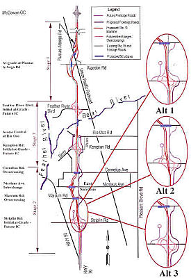 In 2007, it was noted that the California Transportation Commission allocated $126 million for a
project in Yuba and Sutter counties to widen Route 70 to four lanes from
south of East Nicolaus (apx 070 SUT R4.102) to the Bear River (apx 070 YUB
0.127). The East Nicolaus bypass would relieve traffic congestion and
improve highway safety, and is scheduled to last from spring 2008 to fall
2011. The bypass will be to the west of East Nicolaus. This southern
section of Route 70 closely follows the route of the old Sacramento
Northern Railroad. South of East Nicolaus, the old rail grade is visible
on the west side of the highway. North of East Nicolaus, the grade is
visible as Route 70 zags at the intersection of El Centro Blvd - the grade
runs between Route 70 and El Centro Blvd north to Kempton Road. This
widening will make Route 70 a 4-lane facility from the the southern end of
the route all the way to Marysville. In October 2009, a local newspaper
reported on the effects of the rerouting on East Nicolaus, for Caltrans
rerouted Route 70 around East Nicolaus partly to eliminate traffic backups
at a stop sign where the highway and Nicolaus Avenue met. The switch was
part of an $82 million project to expand Route 70 to four lanes between
Route 99 and Marysville, a project set for completion in 2011. Most
residents are happy. Marcum-Ilinois School officials said their traffic
situation has improved immeasurably, with far fewer cars and trucks
zooming past the school, which fronts what was Route 70 until June 2009.
The highway now runs about a half-mile to the west, with an full
interchange to Nicolaus Avenue. Some businesses adapted to the rerouting
with signs, such as the Country Store, a stone's throw from the former
intersection but far from eyesight of drivers now. Other businesses
failed, such as The Hub, a burger joint near the intersection whose menu
board still boasts of a Dragon Burger with 2⅓ pounds of beef, closed
its doors; the restaurant occupies what was once Perozzi's, a popular
eatery for locals and commuters for more than 36 years. The old road is
now known as El Centro Boulevard, the name used before Route 70 was
established. Yet modern mechanisms haven't caught up--Google Maps still
lists the road by the Route 70 designation.
In 2007, it was noted that the California Transportation Commission allocated $126 million for a
project in Yuba and Sutter counties to widen Route 70 to four lanes from
south of East Nicolaus (apx 070 SUT R4.102) to the Bear River (apx 070 YUB
0.127). The East Nicolaus bypass would relieve traffic congestion and
improve highway safety, and is scheduled to last from spring 2008 to fall
2011. The bypass will be to the west of East Nicolaus. This southern
section of Route 70 closely follows the route of the old Sacramento
Northern Railroad. South of East Nicolaus, the old rail grade is visible
on the west side of the highway. North of East Nicolaus, the grade is
visible as Route 70 zags at the intersection of El Centro Blvd - the grade
runs between Route 70 and El Centro Blvd north to Kempton Road. This
widening will make Route 70 a 4-lane facility from the the southern end of
the route all the way to Marysville. In October 2009, a local newspaper
reported on the effects of the rerouting on East Nicolaus, for Caltrans
rerouted Route 70 around East Nicolaus partly to eliminate traffic backups
at a stop sign where the highway and Nicolaus Avenue met. The switch was
part of an $82 million project to expand Route 70 to four lanes between
Route 99 and Marysville, a project set for completion in 2011. Most
residents are happy. Marcum-Ilinois School officials said their traffic
situation has improved immeasurably, with far fewer cars and trucks
zooming past the school, which fronts what was Route 70 until June 2009.
The highway now runs about a half-mile to the west, with an full
interchange to Nicolaus Avenue. Some businesses adapted to the rerouting
with signs, such as the Country Store, a stone's throw from the former
intersection but far from eyesight of drivers now. Other businesses
failed, such as The Hub, a burger joint near the intersection whose menu
board still boasts of a Dragon Burger with 2⅓ pounds of beef, closed
its doors; the restaurant occupies what was once Perozzi's, a popular
eatery for locals and commuters for more than 36 years. The old road is
now known as El Centro Boulevard, the name used before Route 70 was
established. Yet modern mechanisms haven't caught up--Google Maps still
lists the road by the Route 70 designation.
In articles noting the completion of the Route 149 widening, it was noted that there are also plans to widen Route 70 to 4 lanes from the junction of Route 99 in Sutter County (~ SUT 0.0) to Marysville (~ YUB 14.59). It will also be 4 lanes in the Oroville area and north to the junction of Route 191. About 2 more miles will be widened to 4 lanes immediately south of Oroville.
In May 2019, the CTC authorized relinquishment of right of way in the
county of Sutter (County) on Route 70 from Route 99 to Rio Oso Road
(03-Sut-70-PM 0.0/7.6, 5 segments), consisting of superseded highway and
collateral facilities. The County, by cooperative agreement dated June 11,
2003, and by amendment to agreement dated April 21, 2011, agreed to accept
the relinquishment. The County, by letter dated March 6, 2019, agreed to
waive the 90-day notice requirement and accept title upon relinquishment
by the State.
(Source: May 2019 CTC Minutes, Agenda Item 2.3c)
In January 2019, the CTC authorized vacation of right of way in the
county of Sutter along Route 70 from 0.15 mile south of to 0.30 mile north
of Marcum Road (2 segments, 03-Sut-70-PM R2.8/R3.3), consisting of
superseded highway right of way no longer needed for State highway
purposes. It has been determined that the facilities in the vacation
resolution summarized below are not essential to the proper functioning of
the State Highway System and may be disposed of by vacation. Upon the
recording of the approved vacation resolution in the county where the
facilities are located, the public’s right to use the facilities
will be abandoned. The vacation complies with Sections 892, 8313 and
8330.5 of the Streets and Highways Code.
(Source: January 2019 CTC Minutes, Agenda Item
2.3d)
In October 2013, the CTC received a MND for future consideration of funding regarding a project located on Route 70 east of the Feather River, approximately 13 miles south of the City of Marysville in Yuba County. The proposed project will replace the existing at-grade intersection of Feather River Boulevard at Route 70 (apx 070 YUB R0.353) with a modified L-1/L-9 configuration interchange. The interchange will include a five-lane overcrossing of Route 70, five interchange ramps, removal of the existing at-grade intersection and traffic signal, and utility relocation.
In December 2013, the CTC approved funding $4.361M for the Feather River Boulevard/Route 70 Interchange in Yuba County near Plumas Lake and north of Bear River at the southern intersection of Feather River Boulevard and Route 70 (apx 070 YUB R0.353) . The project will remove the traffic signal and construct interchange.
Plumas Lake Blvd Interchange (~ YUB R3.472)
As of November 2007, construction had begun on an interchange with Plumas Lakes Blvd (070 YUB R3.472). It is just to the south of the Union Pacific RR/Arobga Rd twin bridges.
In January 2025, it was reported that the Biden
administration's U.S. Department of Transportation (USDOT) on 1/7/2025
announced that it will award 25 California projects a combined $258
million for transportation infrastructure upgrades. The grants come
through three programs funded by the Bipartisan Infrastructure Law (BIL):
the Rebuilding American Infrastructure with Sustainability and Equity
(RAISE) Grant Program, the Reconnecting Communities Pilot (RCP) Grant
Program, and the Rural Surface Transportation Grant (Rural) Program. It is
unclear how these grants were impacted by subsequent Trump administration
actions to rescind grants. In one of these grants, Yuba County received
$35.52 million for a project that will extend Plumas Lake Boulevard
eastward, over Route 70, using two bridges, one spanning the Union Pacific
Railroad (UPRR) and one spanning the Western Pacific Interceptor Canal
(WPIC), to connect easterly to Plumas-Arboga Road. The project will
eliminate an existing at-grade UPRR crossing on Plumas-Arboga Road. The
extension will also serve the proposed location for a new North Valley
Rail Stop.
(Source: Railway Age, 1/8/2025)
The following project is planned this route: Marysville Bypass. Starting at Route 70/Route 65 junction (070 YUB R8.414), running E of Marysville and linking with the existing Route 70 freeway south of Oroville (apx 070 BUT 11.532). Note that this bypass was later deprecated for the widening discussed below.
 Naming
 The Feather River Bridge and Overhead (Bridge № 18-0009) on Route 20 from PM SUT
17.001 in the County of Sutter, City of Marysville, to PM YUB 0.450 in the
County of Yuba, City of Yuba City is named the “POW/MIA Bridge”.
This naming was initiated by the Marysville Veterans of Foreign Wars Post
948, who were paying tribute to the POW/MIA flag, with Past Commander
Brock Bowen taking the lead on this endeavor. The National League of
Families of American Prisoners and Missing in Southeast Asia adopted the
POW/MIA flag in January 1972. That same year, the National POW/MIA Flag
Act (Section 902 of Title 36 of the United States Code) was enacted and it
requires the POW/MIA flag to be displayed on certain federal properties,
including the White House and the United States Capitol Building, on all
days on which the flag of the United States is displayed. The California
Department of Veterans Affairs estimates that in 2024 there were 6,013
local veterans from the County of Sutter and 7,290 local veterans from the
County of Yuba. Further, according to the United States Department of
Defense, nearly 81,000 American service members remain missing, having
served in World War II, the Korean War, the Vietnam War, and other
conflicts involving the United States. Named by ACR 16, 7/8/2025, Res.
Chapter 132, Statutes of 2025.
The Feather River Bridge and Overhead (Bridge № 18-0009) on Route 20 from PM SUT
17.001 in the County of Sutter, City of Marysville, to PM YUB 0.450 in the
County of Yuba, City of Yuba City is named the “POW/MIA Bridge”.
This naming was initiated by the Marysville Veterans of Foreign Wars Post
948, who were paying tribute to the POW/MIA flag, with Past Commander
Brock Bowen taking the lead on this endeavor. The National League of
Families of American Prisoners and Missing in Southeast Asia adopted the
POW/MIA flag in January 1972. That same year, the National POW/MIA Flag
Act (Section 902 of Title 36 of the United States Code) was enacted and it
requires the POW/MIA flag to be displayed on certain federal properties,
including the White House and the United States Capitol Building, on all
days on which the flag of the United States is displayed. The California
Department of Veterans Affairs estimates that in 2024 there were 6,013
local veterans from the County of Sutter and 7,290 local veterans from the
County of Yuba. Further, according to the United States Department of
Defense, nearly 81,000 American service members remain missing, having
served in World War II, the Korean War, the Vietnam War, and other
conflicts involving the United States. Named by ACR 16, 7/8/2025, Res.
Chapter 132, Statutes of 2025.
 Business Routes
Oroville. Home to the famous "Business I-70" shield.
 Blue Star Memorial Highway
The portion of Route 70 that is former US 99 was designated as a "Blue Star Memorial Highway" by Senate Concurrent Resolution 33, Ch. 82 in 1947.
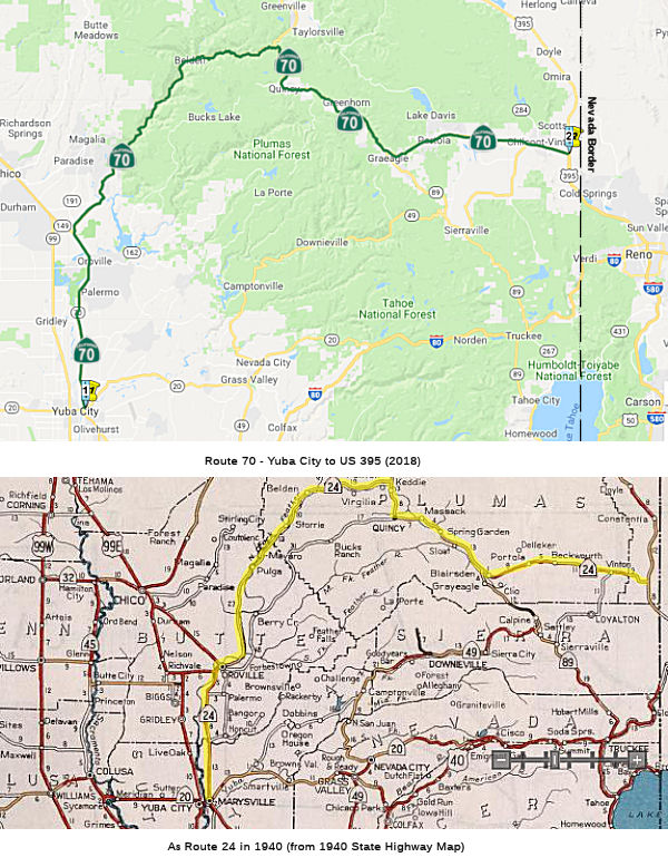 Route 20 in Marysville to Route 395 near Hallelujah Junction via Quincy and
Beckwourth Pass.
Route 20 in Marysville to Route 395 near Hallelujah Junction via Quincy and
Beckwourth Pass.
Post 1964 Signage HistoryIn 1963, Route 70 was defined to run from Route 99 near Catlett Road to Route 395 near Hallelujah Junction via Quincy and Beckwourth Pass. Note that Hallelujah Junction was formerly called Chats, CA.
In 1986, Chapter 928 split the route into the current two segments: (a) Route 99 near Catlett Road to Route 20 in Marysville. (b) Route 20 in Marysville to Route 395 near Hallelujah Junction via Quincy and Beckwourth Pass. The portion in Marysville became part of Route 20.
The route between Blairsden and Indian Falls is cosigned as Route 70/Route 89, although it is legislatively Route 70.
Pre 1964 Signage HistoryThis portion of the Route 70 routing started life in 1919, when the LRN 21 routing replaced former LRN 30, the Oroville-Quincy Highway, between a point NW of Oroville and Quincy. In 1931 the routing was extended from Quincy to Chats, CA (Hallelujah Junction) near (signed) US 395 [LRN 29]. The rationale for the extension was that the extension would extend the Feather River road, [LRN 21], joining' it to [LRN 29] (now US 395) near the latter 's interstate connection with State of Nevada highways. The inclusion in the State system extended State jurisdiction over a section that was projected to eventually be considered state and interstate. It was anticipated that LRN 21 would provide the advertised water grade arterial through the scenic Feather River to the county seat, Quincy. National forest highway in cooperation with Plumas County aid were completing on good standards a surfaced road E of Quincy as funds permitted; but they were unable to complete the connection through Plumas and Lassen counties. State aid permitted that connection.
In 1933, LRN 87 was added to the mix. LRN 87 ran between Marysville and Oroville. In 1934, the routing was signed as Route 24. In the late 1930s, it was resigned as Alternate US 40 (and was likely still Route 24). In 1963, it was renumbered as Route 70 when that route number was freed by the decomissioning of US 70.
In the late 1930s, there was a temporary routing of Alternate US 40 that took a more southern alignment than the current Route 70 routing, running through Berry Creek and Bucks Lake to Quincy along Orville-Quincy Highway, Spanish Ranch, and Bucks Lake Road. This appears to be the former LRN 30. Much of that route is no longer part of the state highway system, although the portion from Oroville to Brush Creek is part of Route 162.
 Freeway
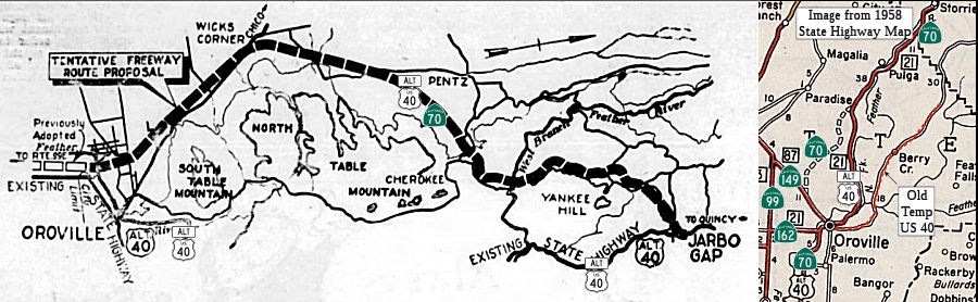 In May 1956, the Feather River Bulletin published an article, together with a proposed
route map, for the rerouting of Alt US 40 (Route 70) E of Oroville between
Oroville and Jarbo Gap. This was called the Lake Oroville Bypass
Alignment. The article noted:
In May 1956, the Feather River Bulletin published an article, together with a proposed
route map, for the rerouting of Alt US 40 (Route 70) E of Oroville between
Oroville and Jarbo Gap. This was called the Lake Oroville Bypass
Alignment. The article noted:
(Source: Feather River Bulletin, 5/3/1956, via Joel Windmiller,
2/23/2023)
J. W. Trask, District engineer of the Division of Highways, announced today that preliminary studies for a future relocation on a freeway basis of 19.3 miles of US 40 Alternate (Feather River Highway [Route 70]) in Butte County between Montgomery Street in Oroville and Jarbo Gap have now reached a stage to permit a tentative conclusion as to basic plan. Relocation of the Feather River Highway is one of the first steps in the proposed construction of the Oroville Dam, a portion of the Feather River Project. Before the dam can be built, this important state highway will have to be relocated. G. T. McCoy, state highway engineer has instructed Trask to hold a public meeting to explain the various studies and the tentative conclusions reached by the highway engineers. The meeting will be held in Oroville on May 9, at 10 AM in the supervisor's room in the county courthouse. Trask urged all interested individuals and civic groups to attend the meeting and to present any information which may be pertinent to a freeway routing for the portion of US 40 Alt concerned. This information may be delivered orally or a written statement may be filed with the division of highways. Studies, by the division of the proposed route from Montgomery Street to Jarbo Gap, include all of the numerous factors influencing the location of a highway through developed and semi-developed areas. The factors involved include consideration of the proposed Feather River dam reservoir, traffic service, cost of construction and right-of-way, future developments, and overall effect on the area, including the city of Oroville. Trask also stated that in addition to local conditions all route studies on 40A have to consider the importance of the road as a primary state highway and a part of the network of strategic highways. The tentative' routing departs from the existing road just west of Oroville, crosses the Feather River on a new bridge, and lies south of the existing Oroville-Chico highway through Thermalito. It swings east again at Wicks Corners. It lies north of Table Mountain between Pentz and Cherokee. It crosses the West Branch of the Feather River at Vinton Gulch and runs north of Yankee Hill, joining the existing highway just west of Jarbo Gap. The tentative routing eliminates many of the sharp curves in the Feather River Canyon. After a public explanation of the route studies between Montgomery Street and Jarbo Gap has been given, a complete report of the data and conclusions, including information provided by interested persons attending the meeting, will be forwarded by Trask to State Highway Engineer McCoy. McCoy will furnish the information and his recommendation for routing to the California highway commission. Route adoption's responsibility for the commission.
StatusRoute 70 Passing Lane Project Yuba/Butte County - 03-Yub-70 PM 14.70/25.82, 03-But-70 PM 0.0/11.8
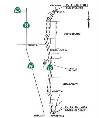 In December 2013, the Project Study Report proposed what became PPNO 9801 (9801A, 9801B), on
Route 70 between 14th St. in Marysville to Ophir Road in
Oroville, a project to widen the existing 2-lane conventional highway into
a 5-lane facility, 2 lanes per direction with a continuous two-way left
turn lane. The existing freeway north of Ophir Road will be extended S to
Palermo Road. The current facility included several driveways along the
corridor serving residential, agriculatural, and industrial properties; no
new connections were proposed. The report noted that there have been
several proposed improvements along this corridor including the proposed
"Marysville Bypass to Oroville Freeway", which would have used a new
alignment. This project does not use that alignment. The 2009
Transportation Concept Report proposed multiple "passing lane" projects,
but has been revised for a continuous five-lane facility. The corridor has
been divided into six segments:
In December 2013, the Project Study Report proposed what became PPNO 9801 (9801A, 9801B), on
Route 70 between 14th St. in Marysville to Ophir Road in
Oroville, a project to widen the existing 2-lane conventional highway into
a 5-lane facility, 2 lanes per direction with a continuous two-way left
turn lane. The existing freeway north of Ophir Road will be extended S to
Palermo Road. The current facility included several driveways along the
corridor serving residential, agriculatural, and industrial properties; no
new connections were proposed. The report noted that there have been
several proposed improvements along this corridor including the proposed
"Marysville Bypass to Oroville Freeway", which would have used a new
alignment. This project does not use that alignment. The 2009
Transportation Concept Report proposed multiple "passing lane" projects,
but has been revised for a continuous five-lane facility. The corridor has
been divided into six segments:
(Source: January 2014 Project Study Report)
In October 2017, the CTC added the following project into the SHOPP: 03-But-70 5.6/8.8: On Route 70 in Butte County: Near Oroville, from 0.3 mile north of Cox Lane to south of Palermo Road. Widen for two-way left-turn lane and standard shoulders, and provide a roadside clear recovery zone. This is Segment 2.
In October 2017, the CTC added the following project into the SHOPP: 03-But-70 8.8/11.8: On Route 70 in Butte County: Near Oroville, from south of Palermo Road to north of Ophir Road. Widen for two-way left-turn lane and standard shoulders, and provide a roadside clear recovery zone. This is Segment 1.
In December 2017, the CTC amended the SHOPP to add the following project, for planning only: 03-But-70 0.0/3.8: On Route 70, in Butte County: Near Oroville, from Yuba County Line to south of East Gridley Road/Stimpson Road; also, in Yuba County on Route 70 from PM 25.7 to PM 25.8. Widen for two-way left-turn lane and standard shoulders. This is part of Segment 4.
In March 2018, it was reported that the California
Transportation Committee approved $400 million in funding to widen the
highway to five lanes between the Yuba County line (~ BUT 0.0) and
Oroville (~BUT 14.708). Construction on the first project, the stretch of
road between Ophir and Palermo roads, south of Oroville, won’t
happen before 2020. The article included a very touching story about Caltrans engineer Paul Inman, who was killed on that dangerous stretch of road. This appears to be segments 1,
2, 3, and part of 4.
(Source: Chico ER News, 3/23/2018)
The 2018 STIP, approved at the CTC March 2018 meeting, appears to adjust the funding for these segments, seemingly delaying two of the segments for a year. The PPNOs involved are PPNO 9801 (Segment 1), PPNO 9801A (Segment 2), PPNO 9801B (Segment 3), PPNO 9824 (Segments 4 and 5).
In January 2019, the CTC amended the SHOPP regarding
this project: 03-But-70 8.8/11.8 8.8/12.1 PPNO
2294. Proj ID 0318000053. Route 70 Near Oroville, from 0.2 mile
south of Palermo Road to 0.2 mile north of Ophir Road. Widen
for two-way left-turn lane and standard shoulders, and provide a roadside
clear recovery zone. Update the project limits to extend the construction
zone. The extended project limits facilitate staging and traffic handling
will allow the project to finish construction in one season.
(Source: January 2019 CTC Minutes, Agenda Item
2.1a(1) Amendment Item 5)
In March 2019, the CTC approved an allocation of
$7,400,000 for the State-Administered STIP Route 70 Passing Lanes (Segment
1) project (PPNO 9801), on the State Highway System, in Butte County,
programmed in 2019-20. Project details: 03-BUT-70 M8.8/R12.1. PPNO
03-9801. Proj ID 0312000155. On Route 70, from 0.1 mile south of Palermo
Road, to 0.3 0.6 miles north of Ophir Road/Pacific
Heights intersection. Construct passing lanes. (Future Consideration of
Funding approved under Resolution E-18-155; December 2018. (EA 3F280, PPNO
9801 combined with EA 03-3H710, PPNO 2294 for construction under EA 3H71U,
Project ID 0319000051)
(Source: March 2019 CTC Minutes, Agenda Item
2.5c.(4))
In November 2019, Caltrans District 3 tweeted: "Today
we celebrated the completion of the SR-70 Segment 1 Safety and Passing
Lanes!"
(Source: Caltrans District 3 Tweet, 11/18/2019)
In March 2020, the CTC approved for future
consideration of funding another segment of this project: Route 70
(03-Yub-70, PM 25.5/25.8, 03-But-70, PM 0.0/3.80) in Butte and Yuba
Counties. Widen highway, construct a bridge, and build other safety
improvements in Butte and Yuba Counties. (PPNO 9801B and 2296) This
project is located within Butte and Yuba Counties on Route 70 and proposes
to widen Route 70 from a two-lane highway to five-lane facility with a
paved center two-way-turn lane median for approximately 4.0 miles north of
the existing Honcut Creek bridges. At Honcut Creek, a new
two-lane bridge structure will be constructed parallel to the existing
structures to span the levee prism and provide additional lanes of
southbound traffic. The project is fully funded and currently programmed
in the 2018 SHOPP and 2018 State Transportation Improvement Program (STIP)
for a total of $65,868,000 which includes Construction (capital and
support) and Right of Way (capital and support). Construction is estimated
to begin in 2021-2022. Additionally, in March 2020, the CTC approved the
following financial allocation: 03-But-70 PM 0.0/3.8, 03-Yub-70 PM
25.7/25.8. PPNO 2296. ProjID 0318000102. EA 3H930. Near Oroville, from
Yuba County Line to south of East Gridley Road/Stimpson Road; also, in
Yuba County on Route 70 from PM 25.7 to PM 25.8. Widen for two-way
left-turn lane and standard shoulders. (Concurrent consideration of
funding under Resolution E-20-14; March 2020.) Financial allocation:
PS&E $3,000,000 R/W Sup $2,500,000.
(Source: March 2020 CTC Agenda, Agenda Item
2.2c.(1), 2.5b.(2a) #4)
Additionally, in March 2020, the CTC approved the
following financial allocation: $9,240,000 for CONST and CON ENG on
03-But-70 PM 5.6/9.1 PPNO 9801A. ProjID 0314000057. EA 3F281. SR70 Passing
Lanes (Segment 2). On Route 70, from 0.1 mile north of Cox Lane to 0.2
mile south of Palermo Road. Construct Passing Lane. (CONST savings of
$180,000 to be returned to Butte County
regional shares.) (CONST savings of $180,000 to be returned to
interregional share balance.) (Future consideration of funding approved
under Resolution E-18-155; December 2018.) (Concurrent allocation for
SHOPP Project EA 03-3H720/PPNO 2295 under Resolution FP-19-61) (EA
03-3F281/PPNO 9801A combined with SHOPP EA 03-3H720/PPNO 2295 under EA
03-3H72U, Project ID 0320000087)
(Source: March 2020 CTC Agenda, Agenda Item
2.5c.(5))
Lastly, in March 2020, the CTC approved the 2020 STIP,
which made no changes to the funding programmed for PPNO 9801, 9801A,
9802B or PPNO 9824. Note that the STIP program stated that the
interregional program "Does Not Include County Shares"; however, the
Interregional numbers seemed to just be duplicates of the county numbers:
(Source: March 2020 CTC Agenda, Item 4.7, 2020 STIP
Adopted 3/25/2020)
| PPNO | Project | Prior | 20-21 | 21-22 | 22-23 | 23-24 | 24-25 |
| 9801 | Psng Lns, Palermo-Ophir, Seg 1 (RIP)(SHOPP)(decr at vote) | 4,070K | 0 | 0 | 0 | 0 | 0 |
| 9801 Interregional | Passing Lanes, Palermo-Ophir, Seg 1 (IIP)(SHOPP) | 4,070K | 0 | 0 | 0 | 0 | 0 |
| 9801A | Passing Lanes, Cox-Palermo, Seg 2 (RIP)(SHOPP) | 1,800K | 4,800K | 0 | 0 | 0 | 0 |
| 9801A Interregional | Passing Lanes, Cox-Palermo, Seg 2 (IIP)(SHOPP) | 1,800K | 4,800K | 0 | 0 | 0 | 0 |
| 9801B | Passing Lanes, East Gridley-Co Line, Seg 3 (RIP) (SHOPP) | 2,300K | 0 | 8,600K | 0 | 0 | 0 |
| 9801B Interregional | Passing Lanes, East Gridley-Co Line, Seg 3 (IIP)(SHOPP) | 2,300K | 0 | 8,600K | 0 | 0 | 0 |
| 9824 | Passing Lanes, Segments 4&5 (APDE) | 4,000K | 4,000K | 0 | 0 | 0 | 0 |
| 9824A | Passing Lanes, Segments 4&5, Phase 1 (NEW) | 0 | 32,000K | 0 | 0 | 0 | 0 |
In June 2021, the CTC approved the following advance
construction phase allocation: $33,310,000. 03-But-70 0.0/3.8. PPNO
03-2296; ProjID 0318000102; EA 3H930. Route 70 Near Oroville, from Yuba
County line to 0.3 mile south of East Gridley Road/Stimpson Road; also in
Yuba County, on Route 70 from PM 25.7 to PM 25.822. Outcome/Output:
Improve safety by widening for two-way left-turn lane and shoulders,
establish 20 feet of clear recovery zone, overlay pavement with rubberized
asphalt, and upgrade drainage. This project will reduce the number and
severity of collisions. Allocation: CON ENG $3,200,000 CONST $28,750,000.
(Future consideration of funding approved under Resolution E-20-14; March
2020.) (SB 1 Baseline Agreement approval under Resolution
SHOPP-P-1920-07B; May 2020.) (EA 3H930/PPNO 03-2296 combined with STIP
funded project EA 3F282/PPNO 03-9801B for construction under EA
3H93U/Project ID 0321000091.) (Related STIP allocation for EA 3F282/PPNO
03-9801B under Resolution FP-20-92.)
(Source: June 2021 CTC Agenda, Agenda Item 2.5b.(3)
#1)
Also in June 2021, the CTC approved an allocation of
$17,200,000 for the State-Administered STIP Route 70 Passing Lanes
(Segment 3) project (PPNO 9801B; ProjID 0318000039; EA 3F282; 03-But-70
0.0/3.6), on the State Highway System, in Butte County, programmed in
2021-22. Allocation time extensions for other projects programmed within
the current Fiscal Year have allowed for sufficient capacity to become
available to fund this advanced project allocation. The project is on
Route 70 from 0.4 mile South or East of Gridley Road to 0.3 mile South of
Butte/Yuba County line. Widen roadway. (Future consideration of funding
approved under Resolution E-20-14; March 2020.) (Contribution from other
sources: $3,200,000 (CON ENG) and $28,750,000 (CONST) in SHOPP funds.) The
allocation is divided as follows: $15,000,000 for construction and
$2,200,000 for construction engineering.
(Source: June 2021 CTC Agenda, Agenda Item
2.5c.(4))
Additionally, in June 2021, the CTC approved an
allocation of $24,500,000 for the State-Administered STIP Passing Lanes
Segment 4 & 5 Project (PPNO 9824; ProjID 0318000186; EA 3F283), on the
State Highway System, in Yuba County. This project is on Route 70
(03-Yub-70 16.2/25.8), from Laurellen Road to Yuba/Butte County Line.
Widen roadway. Allocation: CON ENG $3,200,000 CONST $21,300,000. (Future
consideration of funding approved under Resolution E-20-127; December
2020.) (Contribution from other sources: $9,030,000 (CON ENG) and
$75,800,000 (CONST) in SHOPP funds.) (Concurrent SHOPP allocation for EA
03-4F380 under Resolution FP-20-85. To be combined under a new EA
03-4F38U)
(Source: June 2021 CTC Agenda, Agenda Item
2.5c.(8))
In November 2021, Caltrans District 3 celebrated the
completion of Phase 2 of the Route 70 Safety and Passing Lanes Project in
Butte County this morning. The new roadway improves safety along Route 70
corridor by providing continuous passing opportunities for vehicles from
East Gridley Road to the Butte-Yuba county line. The project is the third
of six major roadway improvement projects completed on Route 70 between
Oroville and Marysville.
(Source: District 3 on FB, 11/2/2021)
In November 2022, it was reported that teams working on
the $63.9 million Route 70 Corridor Improvement Project, which covers the
4-mi. stretch between East Gridley Road to the Butte-Yuba County Line, are
constructing a new 1,400-ft. bridge with standard lanes and shoulders over
Honcut Creek, the longest Caltrans has ever designed. They are also
widening the existing two-lane highway to five lanes (two lanes in each
direction, with a turning lane in the center); creating a continuous
two-way left turn; widening the shoulders to 8 ft.; upgrading the existing
drainage systems; and establishing an area for vehicles veering off the
roadway to return to the main highway. The passing lane segment, between
East Gridley Road and Lower Honcut Road, opened to traffic on Nov. 23,
2022. The new 1,400-ft. long bridge over Honcut Creek will have two
westbound lanes with 8-ft. wide shoulders. The existing bridges cover
eastbound traffic. This is the longest single-span structure that Caltrans
has designed and built. Construction started with the foundation work in
the middle and then worked towards one side and then the other based on
the dimensions of the piles and the equipment needed to construct them and
the foundations. Once the foundation work was complete, a similar process
was used for the deck pours. A fair number of piles were drilled. Not
counting the abutments for the pier, there were 14 foundation CIHD piles
ranging from 100 to 150 feet deep, and some of them were eight and 10 feet
in diameter. There were two abutments and each one had 12 24-inch piles.
As of November 2022, the bridge deck was all poured out and working was in
process to stress the deck. This is followed by work on wrapping up the
abutment deck wall and barrier walls on the bridge. The drainage systems
are completed just under three miles north of the roadway. Once that is
complete, traffic can be moved across the new bridge, permitting
completion of the last bit of the roadway surrounding the existing bridges
for the current traffic pattern. The new bridge has been built through a
flood plain and there were some environmental timing restrictions that the
contractor had to work around. Once the bridge is stressed, the
contractors can release the falsework and get out of the floodplain.
(Source: Construction Equipment Guide, 11/30/2022)
In May 2023, it was reported that traffic has shifted
onto the newly constructed Honcut Creek Bridge on Route 70 at Laurellen
Road and the Yuba County and Butte County line. Caltrans said the roadway
is the final construction phase of a $63.3-million Butte County project to
construct the new bridge and passing lanes between East Gridley Road and
the Yuba County and Butte County line. Officials expect it to be completed
sometime in Summer 2023.
(Source: $ Appeal-Democrat, 5/18/2023)
In September 2023, it was reported that after years of
construction, Caltrans and its partners have finally wrapped up this
project. The cost of the project came out to $63.9 million with $41.4
million coming from the Infrastructure Investment and Jobs Act at the
federal level. There were a lot of challenges. Caltrans worked with the
Army Corps of Engineers and with the levees—there were multiple
levees and rivers that had to be dealt with.
(Source: Chico Enterprise Record, 9/15/2023)
In August 2011, the CTC approved for future consideration of funding a project that will rehabilitate the route in the city of Marysville, including new pavement, curb ramps, and sidewalks. The CTC also approved $41,500,000 in SHOPP funding for repairs in Marysville, from First Street Undercrossing to east of Binney Junction; also on Route 20 from Feather River Bridge to 0.1 mile east of Levee Road, that will rehabilitate 17.0 lane miles of roadway to improve the ride quality, prevent further deterioration of the road surface, minimize the costly roadway repairs and extend the pavement service life. (Vicinity of 070 YUB 14.734)
SR 70 Binney Junction Roadway Rehabilitation and Complete Streets Project (03-Yub-70, PM 14.8/15.7)
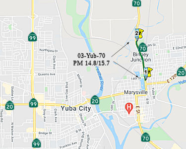 In March 2021, the CTC approved an amendment to Resolution FP-20-44, originally approved in
January 2021, to rescind an allocation of $6,715,000 for the Plans,
Specifications & Estimates (PS&E) and Right of Way (RW) support
phases for 03-Yub-70, PM 14.8/15.7. SR 70 Binney Junction Roadway
Rehabilitation and Complete Streets Project (EA 0H160/PPNO
03-9820). What happened was this: At the January 2021 Commission meeting,
the Department presented a concurrent environmental document, related to
this allocation, for approval (I didn't capture it for these pages because
the summary didn't make clear the full extend of the project). However, at
the meeting, the related environmental document was not approved, and the
related SHOPP allocation was inadvertently approved. In accordance with
SHOPP Guidelines, environmental clearance is required for all projects
before allocations for PS&E, RW and Construction can be approved.
Therefore, the Commission needed to rescind the allocation of $6,715,000
for the PS&E and RW support phases.
In March 2021, the CTC approved an amendment to Resolution FP-20-44, originally approved in
January 2021, to rescind an allocation of $6,715,000 for the Plans,
Specifications & Estimates (PS&E) and Right of Way (RW) support
phases for 03-Yub-70, PM 14.8/15.7. SR 70 Binney Junction Roadway
Rehabilitation and Complete Streets Project (EA 0H160/PPNO
03-9820). What happened was this: At the January 2021 Commission meeting,
the Department presented a concurrent environmental document, related to
this allocation, for approval (I didn't capture it for these pages because
the summary didn't make clear the full extend of the project). However, at
the meeting, the related environmental document was not approved, and the
related SHOPP allocation was inadvertently approved. In accordance with
SHOPP Guidelines, environmental clearance is required for all projects
before allocations for PS&E, RW and Construction can be approved.
Therefore, the Commission needed to rescind the allocation of $6,715,000
for the PS&E and RW support phases.
(Source: March 2021 CTC Agenda, Agenda Item
2.5b.(2c))
Then, at the same meeting in March 2021, the CTC
accepted the FEIR and approved for future consideration of funding the
following project: 03-Yub-70, PM 14.8/15.7. SR 70 Binney Junction
Roadway Rehabilitation and Complete Streets Project. Replace
underpasses and add lanes on Route 70 in Yuba County. (FEIR) (PPNO 9820)
(SHOPP). This project is located on Route 70 in the City of Marysville,
from 0.1 mile south of 14th Street to just north of Cemetery
Road in Yuba County. The purpose of this project is to rehabilitate the
existing roadway to reduce maintenance expenditures; improve safety,
traffic operations, inadequate shoulders and vertical clearances to
facilitate goods movement, sight distance, bicycle/pedestrian facilities,
comply with Americans with Disabilities Act; increase multimodal mobility
and operations to meet complete streets and safe routes to school
policies. This project is not fully funded and is currently programmed in
the 2020 State Highway Operation and Protection Program (SHOPP) for a
total of $111,000,000 and $97,000,000 is currently through G-13
Contingency. Construction is estimated to begin Spring 2023. The scope, as
described for the preferred alternative, is consistent with the project
scope programmed by the Commission in the 2020 SHOPP. A Final
Environmental Impact Report (FEIR) has been completed. Potential impacts
associated with the project can all be mitigated to below significance,
but public interest necessitated preparation of an FEIR.
(Source: March 2021 CTC Agenda, Agenda Item
2.2c.(5))
Then, with all that cleared out and the FEIR approved,
in March 2021 the CTC approved the following pre-construction SHOPP SB1
support phase allocation(s): $6,715,000 for the 2020 SHOPP preconstruction
project phases for design and R/W support for the Route 70 Roadway
Rehabilitation project in Yuba County: #1. $3,940,000 (PS&E,
$3,500,000 programmed); $2,775,000 (R/W Sup, $2,500,000 programmed).
03-Yub-70 14.8/15.7. PPNO 03-9820; ProjID 0315000082; EA 0H160. Route 70
In and near Marysville, from south of 14th Street to north of
Cemetery Road. Roadway rehabilitation and operational improvements
including turn pockets and auxiliary lanes. (Concurrent
consideration of funding under Resolution E-21-35; March 2021.)
(Concurrent Amendment under SHOPP Amendment 20H-006; March 2021.) (As part
of this allocation request, the Department is requesting to extend the
completion of the PS&E phase an additional 7 months beyond the 36
month deadline.) (As part of this allocation request, the Department is
requesting to extend the completion of the R/W Sup phase an additional 36
months beyond the 72 month deadline.) (Nineteen month time extension for
PS&E and R/W Sup approved under Waiver 19-29; June 2019.) Prog year
23-24.
(Source: March 2021 CTC Agenda, Agenda Item
2.5b.(2d) #1)
In December 2021, the CTC approved an allocation of
$15,300,000 for the Right of Way (RW) capital phase for the Roadway
Rehabilitation SHOPP project (PPNO 9820), on Route 70, in Yuba County,
programmed through Fiscal Year 2023-24, of which $1,530,000 has been
expended through the RW capital annual allocation. This project is located
in the City of Marysville (City) in the County of Yuba (County). The
Department in cooperation with the County, the City, and Union Pacific
Railroad (UPRR) proposes to rehabilitate Route 70, from 0.1 mile south of
14th Street to north of Cemetery Road. The project will provide
complete streets aspect, rehabilitate existing pavement, reduce traffic
congestion, improve operations and safety, and comply with Department,
UPRR, and local agency standards. Partial and full acquisitions, as well
as permanent and temporary construction easements, are required from
approximately 23 private properties. The acquisitions and easements will
provide the access needed to construct driveways and sidewalks, install
traffic signals, intersection improvements,and Transportation Management
System elements, complete utility relocation, and provide drainage
improvements. The total RW permanent acquisition is estimated at
approximately 8.75 acres with an additional 5.2 acres needed for temporary
use. The proposed improvements will significantly impact the perpendicular
parking stalls in front of commercial businesses. A relocation of utility
facilities is also required for the project. The Department will be
coordinating with multiple agencies to address more than 50 power and
communication poles, and city water and services. A railroad agreement is
also required with UPRR for review and approval of project features that
impact the railroad. Although this allocation request is for the full
$15,300,000, the funds will be committed over multiple fiscal years. The
Department has committed $1,530,000 through the RW capital annual
allocation to complete environmental clearance and project approval in
2017-18, 2018-19, 2019-20, and 2020-21. The Department anticipates
committing an additional $6,280,000 in 2021-22 and $6,140,000 in 2022-23.
The remaining $1,350,000 would be committed in 2023-24.
(Source: December 2021 CTC Agenda, Agenda Item
2.5b.(5))
In December 2022, the CTC amended this project in the
SHOPP as follows: 03-Yub-70 14.8/15.7. PPNO 03-9820; ProjID 0315000082; EA
0H160. Route 70 In and near Marysville, from south of 14th
Street to north of Cemetery Road. Roadway rehabilitation and operational
improvements including turn pockets and auxiliary lanes. This is a
Construction Manager/General Contractor (CMGC) project. Note:
Update description to include CMGC as the new recommended delivery method.
The project has challenging construction staging and traffic control,
levee relocation, railroad structures, and multiple utility relocations.
The innovative CMGC delivery method will assist during design, manage
risks during construction, and will save project time and mitigate risks.
(Source: December 2022 CTC Agenda, Agenda Item
2.1a.(1d) #7)
In March 2023, the CTC approved an additional
$6,250,000 in Capital Outlay Support (COS) for this project to complete
the Plans, Specifications and Estimates (PS&E) phase. This project is
located on Route 70, in Yuba County, in the City of Marysville (City),
from south of Fourteenth Street to north of Cemetery Road. The project
will rehabilitate the roadway, make operational improvements which include
turn pockets and auxiliary lanes, and replace three Union Pacific Railroad
(UPRR) structures (the southern structure known as the Marysville
underpass and the northern two structures known as the Binney Junction
underpass). In addition, the project will incorporate complete streets,
active transportation, and safe routes to school elements. The cost
increase in PS&E is due to the complexity of the project scope and
largely stems from the change in scope for the replacement of the
northerly UPRR structure known as the Binney Junction underpass. The
underpass is currently made up of two structures, each carrying a single
set of railroad tracks. During PA&ED, the planned scope was to replace
the two existing structures with two new structures to the south. This
would meet the requirements of UPRR to have uninterrupted use of the
tracks during construction and reduce right of way impacts on the Yuba
Sutter Transit facility located to the south of the structures. During
PS&E, after submittal of the preferred alternative for the new track
alignment and both underpasses to UPRR for review and approval, UPRR
strongly questioned the Department’s design for Binney Junction
underpass and the ability to construct both new structures without
disrupting the operation of their facilities. To address their concerns, a
new proposal was developed to construct one new bridge accommodating both
sets of tracks. This required re-aligning the structure further south and
redesigning the track alignment. Constructing one structure would greatly
improve safety for workers, reduce the number of stages, be able to
maintain UPRR operations, and reduce impacts to the travelling public. The
change in rail design also caused the Marysville underpass structure to be
shifted, the roadway profile of Route 70 to be lowered to maintain the
required vertical clearance, and additional redesign to accommodate the
connections with several local roads to Route 70 between the two
underpasses. UPRR also required the redesign of the retaining walls to
improve long-term maintenance. The proposed modifications are well within
the environmental study limits and do not require a re- evaluation or
amendment to the environmental document. The PS&E support cost
increase associated with these changes is approximately $3,300,000. The
change in the Binney Junction underpass structure location and the track
realignment also impacted the work needed at one of the three floodgate
structures located within the project limits. The realignment impacted
this floodgate, and the Department will have to design a replacement
floodgate at a new location further northeast of the existing floodgate.
The PS&E support cost increase associated with the redesign to include
this floodgate is approximately $200,000. In addition, as the Department
was consulting with the Central Valley Flood Protection Board (CVFPB),
United States Army Corp of Engineers (USACE), and the Marysville Levee
District, it was evident that that the new alignment was impacting the
levee and mitigation plan identified in PA&ED, the use of relief wells
for seepage mitigation was not acceptable and the mitigation had to be
changed to slurry cut-off walls instead. CVFPB and USACE also required a
change in the seepage mitigation plan to also include cut-off walls in the
west levee. Prior to PS&E, the Department only included the east levee
as requiring seepage mitigation. The PS&E support cost increase
associated with the redesign of the levee and seepage mitigation strategy
is approximately $500,000. The change to the replacement strategy of the
UPRR structures and track alignment also impacted the existing high
pressure gas line. Originally, the Department was going to protect it in
place. However, it was determined that the protect-in-place method would
not work, and the PS&E now had to accommodate the relocation of the
gas line. The PS&E support cost increase associated with the
relocation of the gas line is approximately $150,000.
(Source: March 2023 CTC Agenda, Agenda Item 2.5e.(4))
In May 2023, the CTC amended this project in the 2022
SHOPP as follows: 03-Yub-70 14.8/15.7. PPNO 03-9820; ProjID 0315000082; EA
0H160. Route 70 In and near Marysville, from south of 14th
Street to north of Cemetery Road. Roadway rehabilitation and operational
improvements including turn pockets and auxiliary lanes. This is a
Construction Manager/General Contractor (CMGC) project. Note: Split this
Construction Manager/General Contractor (CMGC) parent project into EA
0H161/PPNO 03-9820A to be constructed as independent construction
contract-Early Work Package No. 1. Allocation ($ × 1,000): PA&ED
$3,000; PS&E $3,500; R/W Sup $2,500; ⊘Con
Sup $12,000 $10,400; R/W Cap $15,300; ⊘Const
Cap $100,650 $84,650; TOTAL $136,950 $119,350.
FY23-24.
(Source: May 2023 CTC Agenda, Agenda Item 2.1a.(1d) #17)
In January 2025, it was reported that the Binney
Junction Project seeks to improve bridge clearance at two underpasses,
relieve traffic congestion, and create better conditions for pedestrians
and bicyclists in Marysville. The improvements will be concentrated on a
roughly one-mile stretch of Route 70 between 14th Street (near
the Dollar Tree) to just north of the Binney Junction, up near the
Marysville cemetery entrances. The project is focused on improving safety
for those who walk and bike in and around the project area. It'll also
widen the road–creating four lanes instead of two. Finally, the
project will replace the Binney Junction Railroad underpass and the
Marysville Railroad underpass. The latter is dubbed the 'can opener' due
to its low clearance, which has caused issues for trucks in the past.
Specifically, the road will also be lowered under the bridges.
Construction is set to begin in fall 2025 and is expected to last for
about two years.
(Source: MSN/KXTV, 01/2025)
In May 2025, the CTC approved for future consideration
of funding 03-Yub-70, PM 14.8/15.7; PPNO 03-9820; ProjID 0315000082; EA
0H160. State Route 70 Binney Junction Roadway Rehabilitation and
Complete Streets Project. Replace Binney Junction Underpass and
Marysville Railroad Underpass, make operational and safety improvements
which include a turn pocket and 2 auxiliary lanes on Route 70 from post
miles 14.8 to 15.7 in Yuba County.The Project would provide complete
streets elements, rehabilitate existing pavement, reduce future traffic
congestion, improve operations and safety, and comply with current
Caltrans, Union Pacific Railroad, and local agency standards.
Specifically, the Project, which is a length of 0.9 mile, would add two
auxiliary lanes to the existing two travel lanes, a continuous two-way
left turn lane, shoulders, sidewalks, a grade separated bicycle lane, and
signalized intersections, and the Project would also replace the
Marysville Underpass and Binney Junction Underpass, which are two Union
Pacific Railroad structures. For all projects that are seeking funding
through a program under the purview of the Commission, full compliance
with CEQA is required. The Commission will not allocate funds to projects
for design, right-of-way, or construction until the environmental document
is complete, and the Commission has approved the environmentally cleared
project for future consideration of funding. On February 20, 2025,
Caltrans certified the Final Environmental Impact Report for the Project.
Caltrans found that the Project would have the potential to impact, at a
less than significant level, aesthetics, air quality, biological
resources, cultural resources, geology and soils, greenhouse gas
emissions, hazards and hazardous materials, hydrology and water quality,
noise, population and housing, public services, recreation,
transportation, utilities and service systems. Avoidance and minimization
measures addressing already less than significant impacts include
implementation of Caltrans’ special provisions and standard
specifications during construction, purchasing seasonal wetlands credits,
adherence to a Cultural Resources Management Plan, adherence to regulatory
and state standards and requirements, including the California Building
Code and Caltrans Specifications, implementation of construction site Best
Management Practices, and work stoppage if paleontological resources are
encountered. No mitigation is required since the impacts are less than
significant. Further, while there may be a potential for impacts on
unknown archaeological resources, impacts would be addressed through a
Cultural Resources Management Plan in compliance with Public Resources
Code 5024.
(Source: May 2025 CTC Agenda, Agenda Item 2.2c.(5))
In May 2025, the CTC approved a request for an
additional $10,000,000 in Right of Way (RW) Capital for 03-Yub-70, PM
14.8/15.7; PPNO 03-9820; ProjID 0315000082; EA 0H160. State Route 70
Binney Junction Roadway Rehabilitation and Complete Streets Project.
The project will rehabilitate the roadway, make operational improvements,
which include turn pockets and auxiliary lanes, and replace three Union
Pacific Railroad (UPRR) structures (the southern structure known as the
Marysville underpass and the northern two structures known as the Binney
Junction underpass). In addition, the project will incorporate complete
streets, active transportation, and safe routes to school elements. In
April 2016, this project’s RW Capital was programmed for $200,000 in
the SHOPP for allocation in Fiscal Year 2018-19. In June 2017, the project
was amended to increase RW Capital to $5,000,000 and move out the
allocation of the Construction and RW Capital phases to 2020-21. In June
2019, the project was amended again to move out the allocation of the
Construction and RW Capital phases to 2021-22 due to a delay to the
project as multiple technical studies are required for the environmental
document, and public controversy is anticipated due to the project size
and past corridor history. In March 2021, the project was further amended
to increase RW Capital to $15,300,000 due to an increase in the number of
parcel acquisitions, railroad coordination, permits, and mitigation costs,
and move out the allocation of the Construction and RW Capital phases to
2023-24 due to delays that occurred during the environmental phase to
complete complex technical studies, and further extensive coordination
with external agencies. In December 2021, the project was allocated for
$15,300,000 in RW Capital. In December 2022, it was determined to use the
Construction Manager/General Contractor delivery method. In June 2024, the
project requested an allocation time extension for the Construction phase.
However, the request was deferred to the August 2024 meeting and approved
for 14 months. In March 2025, the project received G-12 funds in the
amount of $1,730,000 for the RW Capital phase. At this time, the RW
Capital phase is currently 65 percent complete, and the remaining budget
is $2,300,000, which is insufficient to complete the phase. The project
realized cost increases due to increased utility relocation efforts. The
original utility relocation costs were underestimated during the
programming of this project. At the time that the utility estimate was
prepared it was prior to the Project Approval and Environmental Document
(PA&ED) phase and the Department is prohibited from engaging in
significant discussions with the utility companies that may be impacted as
the interaction could be perceived as swaying the ultimate preferred
alternative selection. Due to this, the determination of cost liability,
as split between the Department and the utility owners, is an educated
estimate and there is no way to provide an accurate number at that stage.
In this instance, it was assumed that liability and the total cost of
relocations would fall to three utility companies when ultimately it was
determined that the entire costs were the responsibility of the
Department. This discrepancy led to an increase in utility costs. The
Department’s original estimate for utilities was $677,000, but it is
now estimated at just over $10,000,000.
(Source: May 2025 CTC Agenda, Agenda Item 2.5e.(3))
In July 2025, it was reported that Caltrans has
announced the State Highway 70 Safety Improvement Project, which includes
construction on several parts of the roadway in Yuba County. According the
Caltrans, the project is based on reports that showed 85 collisions, seven
fatalities, and 32 injuries on Route 70 within a three-year timeframe,
from 2010 to 2013. The project includes several fixes, such as lowering a
road between Laurellen Road and the South Honcut Creek Bridge. There, semi
trucks are known to crash into the overpass because of a lack of space to
get through. Additionally, Caltrans plans to widen intersections, add
lanes, install rumble strips, relocate utility poles, and more. Part of
the project includes increasing the paved shoulder at school bus stops to
provide a safer area for loading and unloading school children. The total
cost is estimated at $104.6 million in federal and state funds.
Preparations for the project have already begun. However, major
construction is slated to start in Spring 2026.
(Source: KXTL-TV Sacramento via MSN, July 2025)
In March 2026, the CTC approved the following 2024 and
2026 SHOPP SB1 pre-construction phase (environmental support, design, and
R/W support) allocation: $4,184,000. 03-Yub-70 14.8/15.7. PPNO 03-9820;
ProjID 0315000082; EA 0H160. Route 70 In and near Marysville, from south
of 14th Street to north of Cemetery Road. Roadway
rehabilitation and operational improvements including turn pockets and
auxiliary lanes. This is a Construction Manager/General Contractor
(CMGC) project. Future consideration of funding approved under Resolution
E-25-43; May 2025. Concurrent R/W Cap allocation under Resolution
FP-25-84; March 2026. Pre-Construction Phase Allocation ($ × $1000):
Budgeted (Actual, if different): PS&E $3,000; RW Sup
$1,184.
(Source: March 2026 CTC Agenda, Agenda Item 2.5b.(2b) #4)
In March 2026, the CTC approved the following SHOPP
construction phase (right of way capital) allocation: $10,500,000.
03-Yub-70 14.8/15.7. PPNO 03-9820; ProjID 0315000082; EA 0H160. Route 70
In and near Marysville, from south of 14th Street to north of Cemetery
Road. Outcome/Outputs: Roadway rehabilitation and operational improvements
including turn pockets and auxiliary lanes. This is a Construction
Manager/General Contractor (CMGC) project. CEQA - EIR, 02/04/2025. NEPA -
FONSI, 12/07/2020. Future consideration of funding approved under
Resolution E-25-43; May 2025. Concurrent COS allocation under Resolution
FP-25-83; March 2026. Pre-Construction Expenditures: Budgeted (Expended):
PA&ED $3,500,000 ($3,425,582); PS&E $3,000,000 ($0);
RW Sup $1,184,000 ($0). Construction Phase Allocation ($
× $1000): Budgeted (Actual, if different): RW Cap
$20,800 ($10,500). This project is located in the City of
Marysville in Yuba County. In cooperation with Yuba County, the City of
Marysville, and Union Pacific Railroad (UPRR), the Department proposes to
rehabilitate Route 70, from 0.1 mile south of 14th Street to
just north of Cemetery Road. The project will restore existing roadway
structural sections and construct a two-way left-turn lane, two auxiliary
lanes, standard shoulders, and sidewalks. To address frequent structure
impacts, the vertical clearance at the Marysville Binney Junction
Underpasses will be improved. Lowering the Route 70 profile at these
locations will meet current clearance standards and improve sight
distance. Lengthened structures will accommodate standard shoulders and
sidewalks, enhance pedestrian and bicyclist safety, and provide complete
street elements. The east levee north of Binney Junction to Cemetery Road
will be relocated to the east to accommodate improvements. Intersections
at Route 70/East 24th Street and Route 70/16th
Street will be signalized, and access from 17th Street will be
removed. The project requires partial and full acquisitions, and permanent
and temporary easements, to construct driveways, sidewalks, traffic
signals, intersection improvements, utility relocations, drainage, and
Transportation Management System elements. Perpendicular parking in front
of businesses will be impacted, requiring a temporary parking lot to
mitigate the loss during construction. Utility relocations include over 50
power and communication poles, city water and sewer services, and gas and
petroleum lines. Coordination with multiple agencies has been required.
Significant railroad involvement necessitates two Construction and
Maintenance Agreements with UPRR for review and approval of project
features affecting tracks and the right of way. In December 2021, the
Commission allocated $15,300,000 in SHOPP funds for the RW Capital phase
of this project. The Department approved $1,730,000 under its delegated
G-12 authority, and a supplemental SHOPP allocation was approved in May
2025 for $10,000,000. Approximately $19,316,000 of the previously
allocated funds have been expended or encumbered, leaving $7,714,000
uncommitted. Due to the construction programming lapsing in January 2026,
this project is being reprogrammed in the 2026 SHOPP. The Department is
requesting to reallocate $10,500,000 concurrently with the 2026 SHOPP
adoption.
(Source: March 2026 CTC Agenda, Agenda Item 2.5b.(4))
March 2026 review of the DRAFT 2026 SHOPP noted the
following updated instance of this project (updates in bold, if
possible): 03-Yub-70 14.8/15.7. PPNO 03-9820; ProjID
0315000082; EA 0H160. Route 70 In and near Marysville, from south of 14th
Street to north of Cemetery Road. Roadway rehabilitation and operational
improvements including turn pockets and auxiliary lanes. This is a
Construction Manager/General Contractor (CMGC) project. Allocation ($
× 1,000): PA&ED —; PS&E $3,000; R/W
Sup $1,184; Con Sup $13,920; R/W Cap $20,800;
Const Cap $145,435; TOTAL $184,339.
Begin Const: 12/16/2026.
(Source: Caltrans SHOPP Page: DRAFT 2026 SHOPP PROPOSED, State Highway Operation and Protection Program, Fiscal Years 2026-27 through 2029-30
(PDF), January 31, 2026; March 2026 CTC Agenda, Agenda Item 4.7)
Simmerly Slough Bridge (03-Yub-70, PM 15.4/16.5)
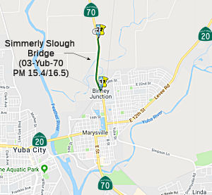 In December 2017, the CTC approved for future consideration of funding a project, located
near the city of Marysville, proposes to replace the Simmerly Slough
Bridge on Route 70 (03-Yub-70, PM 15.4/16.5). The project also proposes to
realign the approach roads at both ends of the new bridge, construct a new
access road to Laurellen Road, and rehabilitate pavement leading to the
new bridge. The project is fully funded and programmed in the 2016 SHOPP
for an estimated total of $82.9 million, which includes Construction
(capital and support) and Right-of-Way (capital and support). Construction
is estimated to begin in December 2019. The scope, as described for the
preferred alternative, is consistent with the project scope programmed by
the Commission in the 2016 SHOPP. The project was also included in the final adopted 2018 SHOPP in March 2018.
In December 2017, the CTC approved for future consideration of funding a project, located
near the city of Marysville, proposes to replace the Simmerly Slough
Bridge on Route 70 (03-Yub-70, PM 15.4/16.5). The project also proposes to
realign the approach roads at both ends of the new bridge, construct a new
access road to Laurellen Road, and rehabilitate pavement leading to the
new bridge. The project is fully funded and programmed in the 2016 SHOPP
for an estimated total of $82.9 million, which includes Construction
(capital and support) and Right-of-Way (capital and support). Construction
is estimated to begin in December 2019. The scope, as described for the
preferred alternative, is consistent with the project scope programmed by
the Commission in the 2016 SHOPP. The project was also included in the final adopted 2018 SHOPP in March 2018.
In May 2019, the CTC approved the following SHOPP
allocation: $82,800,000 (Const, Const Engr). Yuba 03-Yub-70 15.5/16.5.
Route 70 Near Marysville, from 0.1 mile north of Binney Junction Underpass
to 0.3 mile north of Laurellen Road, at Simmerly Slough Bridge No.
16-0019. Outcome/Output: Replace existing bridge to address scour and
seismic deficiencies. As part of this allocation request, the Department
is requesting to extend the completion of CONST and CON ENG an additional
24 months beyond the 36 month deadline.
(Source: May 2019 CTC Minutes, Agenda Item 2.5b.(1)
Item 6)
In April 2021, it was reported that Route 70 will be
closed between Woodruff Lane and Laurellen Road over the weekend of April
12 as crews worked to tie in the newly constructed Simmerly Slough Bridge
with the existing highway. The construction is part of a $60.4 million
project to replace the 64-year-old Simmerly Bridge north of Marysville.
(Source: Chico Enterprise-Record, 4/8/2021)
Laurellen Road to Honcut Creek Bridge Improvements (03-Yub-70, PM 16.2/25.8)
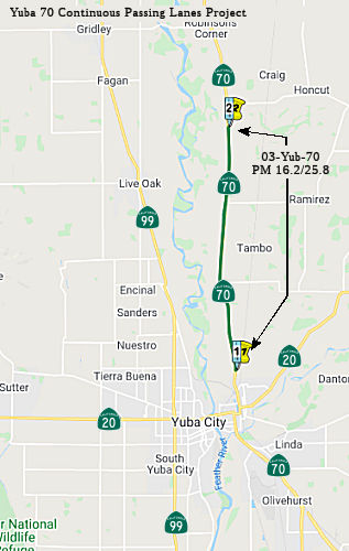 In June 2019, the CTC approved for future consideration of funding a project
located on Route 70 from Laurellen Road to Honcut Creek Bridge, near
Marysville in Yuba County (03-Yub-70, PM 16.2/25.8). The project proposes
to modify the existing lanes, widen shoulders, and improve the clear
recovery zone. The project also proposes to construct left turn lanes and
bring Route 70 up to current design standards. This project proposes to
address the operational and safety issues by reducing injury type
collisions and traffic fatalities including crosscenterline
collisions/fatalities. The project is fully funded and currently
programmed in the 2018 State Highway Operation Protection Program (SHOPP)
for an estimated total of $104.6 million which includes Construction
(capital and support) and Right-of-Way (capital and support). Construction
is estimated to begin in 2021. The scope, as described for the preferred
alternative, is consistent with the project scope programmed by the
Commission in the 2018 SHOPP.
In June 2019, the CTC approved for future consideration of funding a project
located on Route 70 from Laurellen Road to Honcut Creek Bridge, near
Marysville in Yuba County (03-Yub-70, PM 16.2/25.8). The project proposes
to modify the existing lanes, widen shoulders, and improve the clear
recovery zone. The project also proposes to construct left turn lanes and
bring Route 70 up to current design standards. This project proposes to
address the operational and safety issues by reducing injury type
collisions and traffic fatalities including crosscenterline
collisions/fatalities. The project is fully funded and currently
programmed in the 2018 State Highway Operation Protection Program (SHOPP)
for an estimated total of $104.6 million which includes Construction
(capital and support) and Right-of-Way (capital and support). Construction
is estimated to begin in 2021. The scope, as described for the preferred
alternative, is consistent with the project scope programmed by the
Commission in the 2018 SHOPP.
In June 2019, the CTC approved the following SHOPP
support phase allocation: $11,111,000 03-YUB-70 16.2/25.8 PPNO 9058 ProjID
0314000153 Route 70 Near Marysville, from Laurellen Road to South Honcut
Creek Bridge. Widen shoulders and improve clear recovery zone. PS&E
$4,884,000 R/W Support $6,227,000 (Concurrent amendment under SHOPP
Amendment 18H-010.)
(Source June 2019 CTC Minutes, Agenda Item 2.5b.(2)
Item 17)
In June 2019, the CTC approved a Right of Way capital
allocation of $15,200,000 for the SHOPP project (PPNO 9819, ProjID
0314000153, 03-Yub-70 16.2/25.8), in Yuba County programmed in fiscal year
2019-20, that will widen shoulders and improve the clear recovery zone.
The project is located near the City of Marysville from Laurellen Road to
South Honcut Creek Bridge on Route 70 in Yuba County. The project will
widen and pave the shoulders, provide turn lanes and bus pull outs,
straighten and flatten curves, install rumble strips, replace or extend
culverts and establish a Clear Recovery Zone for errant vehicles. Wider
shoulders will allow room for slow moving farm equipment as well as
provide the Department’s Maintenance crews and California Highway
Patrol a safe work zone. With numerous school bus stops within the project
limits, designated locations will also provide students with safer access
to buses. The project scope requires that the Department acquire 84
parcels, including fee acquisitions, permanent easements, and temporary
construction easements. The project will also require coordinating utility
relocations, providing relocation assistance, and securing demolition
contracts. The Department’s Division of Right of Way is actively
managing the delivery risks associated with working near gas lines and
residential acquisitions impacting complex improvements. The original
Right of Way capital programming was based on the right of way capital
estimate developed in 2014. An updated estimate, based on improved mapping
and positive location of utility facilities, was completed in 2018.
However, the total acquisition area has increased and additional utility
conflicts were identified and the current right of way capital estimate is
$15,200,000.
(Source: June 2019 CTC Minutes, Agenda Item
2.5b.(3))
In December 2020, the CTC approved for future
consideration of funding the following project for which a Final
Environmental Impact Report (FEIR) has been completed: Route 70 in Yuba
County (03-Yub-70, PM 16.2/25.8). Construct a 12-foot lane with an 8-foot
shoulder in each direction on Route 70 in Yuba County. (PPNO 9824) This
project is located on Route 70 in Yuba County, post miles 16.2-25.8. The
project proposes to widen Route 70 between Laurellen Road and the
Butte/Yuba County line. The purpose of the project is to achieve a
significant reduction in traffic fatalities and serious injuries. This
project is fully funded and is currently programmed in the 2020 State
Transportation Improvement Program (STIP) for a total of $145,982,000,
which includes construction (capital and support) and Right of Way
(capital and support). Construction is estimated to begin in 2021. The
scope, as described for the preferred alternative, is consistent with the
project scope programmed by the Commission in the 2020 STIP.
(Source: December 2020 CTC Agenda, Agenda Item
2.2c.(5))
In May 2021, the CTC approved Caltrans' request for an
additional $4,900,000 for Right of Way (RW) capital for 03-Yub-70
16.2/25.8, PPNO 03-9819 ProjID 0314000153 EA4F380, Route 70 Near
Marysville, from Laurellen Road to South Honcut Creek Bridge. Widen
shoulders and improve clear recovery zone. Outcome/Output: Widen
shoulders and improve clear recovery zone. The RW for this project was
allocated in June 2019 for $15,200,000. A significant amount of the
allocated RW funds have been expended on the acquisition of properties
needed for the project. At present, the remaining RW capital is
approximately $6,300,000, including the approved G-12 of $1,700,000.
However, this amount is insufficient for the cost to complete mitigation,
settle the remaining acquisitions, pay relocation assistance, complete
clearance and demolition work, and execute various utility agreements. The
capital estimate to complete these items is $11,200,000, representing a
shortfall of $4,900,000; most of which is required to fund the
State’s share of utility relocation costs. These supplemental funds
being requested are needed to execute utility agreements, which are
required prior to achieving RW certification and moving this safety
project to construction. Caltrans will be requesting a construction
capital allocation at the June 2021 Commission meeting with construction
estimated to begin in Fall of 2021. The increase in RW capital is needed
due to increased utility relocation costs. The largest cost increase is to
fund the work to replace a natural gas regulator and gas transmission
valves. For the purposes of programming and allocation, Caltrans estimated
the relocation of these facilities is based on the experience working with
Pacific Gas and Electric’s (PG&E) project liaisons. However,
during coordination with PG&E’s design team during the Plans,
Specifications, and Estimates (PS&E) phase, it was discovered that the
gas regulator and valves cost significantly more than the programmed and
allocated amount. This added $6,500,000 to the utility relocation cost. As
a “lessons learned”, Caltrans aims to have more detailed
discussions early in the project programming process, with the design
teams of the utility companies, regarding complex utility relocations on
agriculture properties. There was also an increase in the number of
utility poles that conflict with the project, when the roadway alignment
was shifted slightly, to reduce impacts to a local business. This minor
adjustment allowed a business to remain open and viable to the community.
These minor adjustments occurred after PA&ED and during the PS&E
phase. Although these minor adjustments contributed to significant savings
in acquisition costs, it also increased the number of poles in conflict
with the project from 255 poles to 267 poles. The additional poles
increased the cost of the overhead electrical by approximately $400,000.
(Source: May 2021 CTC Agenda, Agenda Item 2.5e.(4))
In June 2021, the CTC approved the following
construction phase allocation: $84,830,000. 03-Yub-70 16.2/25.8. PPNO
03-9819; ProjID 0314000153; EA 4F380. Route 70 Near Marysville, from
Laurellen Road to South Honcut Creek Bridge. Outcome/Output: Improve
safety by constructing two-way left-turn lane and left turn pockets, widen
shoulders, improve clear recovery zone, upgrade drainage, and overlay
pavement. This project will reduce the number and severity of collisions.
Allocation: CON ENG $9,030,000 CONST $70,735,000 (Future consideration of
funding approved under Resolution E-19-69; June 2019.) (EA 4F380/PPNO
03-9819 combined with STIP EA 3F283/PPNO 03-9824 for construction under EA
4F38U/Project ID 0321000092.) (Related STIP allocation for EA 3F283/PPNO
03-9824 under Resolution FP-20-97.) (SB 1 Baseline Agreement approval
under Resolution SHOPP-P-1819-13B; June 2019.) (Eighteen month time
extension for CONST and CON ENG approved under Waiver 20-31; June 2020.)
(Source: June 2021 CTC Agenda, 2.5b.(5))
In February 2006, the CTC considered relinquishment of right of way in the County of Butte, between Lower Honcut Road and Grover Lane, consisting of reconstructed and relocated county roads. (apx 070 BUT 0.949)
In May 2015, the CTC authorized relinquishment of right of way in the county of Butte along Route 70 at East Gridley Road and Stimpson Road near Robinsons Corner, consisting of reconstructed county roads. (apx 070 BUT 4.018)
State Route 70 Corridor Improvements Project (03-But-70, PM 5.7/12.1)
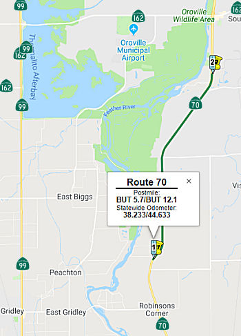 In December 2018, the CTC approved for future consideration of funding a project located on
Route 70 near Oroville in Butte County that proposes to widen Route 70
from 2 lanes to 4 lanes. The proposed project addresses the significant
operational and safety concerns along the Route 70 Corridor. The proposed
project involves two segments for funding purposes and will combine SHOPP
and State Transportation Improvement Program (STIP) funds from FYs 2019-20
and 2020-21 for each segment and is estimated to cost approximately $82.0
million in total. This project is currently programmed in the 2018 SHOPP
for approximately $69.6 million. Construction is estimated to begin in
2018-19 for one segment and 2019-20 for the other segment. The scope, as
described for the preferred alternative, is consistent with the project
scope programmed by the Commission in the 2018 SHOPP.
In December 2018, the CTC approved for future consideration of funding a project located on
Route 70 near Oroville in Butte County that proposes to widen Route 70
from 2 lanes to 4 lanes. The proposed project addresses the significant
operational and safety concerns along the Route 70 Corridor. The proposed
project involves two segments for funding purposes and will combine SHOPP
and State Transportation Improvement Program (STIP) funds from FYs 2019-20
and 2020-21 for each segment and is estimated to cost approximately $82.0
million in total. This project is currently programmed in the 2018 SHOPP
for approximately $69.6 million. Construction is estimated to begin in
2018-19 for one segment and 2019-20 for the other segment. The scope, as
described for the preferred alternative, is consistent with the project
scope programmed by the Commission in the 2018 SHOPP.
A copy of the MND has been provided to Commission
staff. The project will result in less than significant impacts to the
environment after mitigation. The following resource areas may be impacted
by the project: parks and recreation, emergency services, Traffic,
pedestrian and bicycle facilities, cultural resources, visual resources,
water quality, geology/soils, paleontology, hazardous materials,
biological resources. Avoidance and minimization measures will reduce any
potential effects on the environment. These measures include, but are not
limited to, a Traffic Control Plan shall be developed, disturbed areas
shall be reseeded with native grass and wildflowers, a Storm Water
Pollution Prevention Plan shall be developed, credits will be purchased at
an off-site mitigation bank for impacts to wetlands and special species
plants, and pre-construction surveys for the Western Pond Turtle will be
conducted. As a result, an MND was completed for this project.
(Source: December 2018 CTC Minutes, Agenda Item
2.2c(1))
In March 2019, the CTC approved the following
allocation: $19,700,000 Butte 03-But-70 8.8/12.1 PPNO 03-2294. Proj ID
0318000053. Route 70 Near Oroville, from 0.1 mile south of Palermo Road to
0.6 mile north of Ophir Road. Outcome/Output: Improve safety by
widening for two-way left-turn lane and standard shoulders, and provide a
roadside clear recovery zone. This project will reduce the number and
severity of collisions. Future consideration of funding approved under
Resolution E-18-155; December 2018.
(Source: March 2019 CTC Minutes, Agenda Item
2.5b.(4) Project 1)
In March 2020, the CTC approved the following financial
allocation: 03-But-70 PM 5.6/9.1. PPNO 2295. ProjID 0318000054. EA 3H720.
On Route 70 near Oroville, from 0.2 mile north of Cox Lane to 0.1 mile
north of Palermo Road/Welsh Road. Outcome/Output: Improve safety
by widening for two-way left-turn lane and standard shoulders, and provide
a roadside clear recovery zone. This project will reduce the number and
severity of collisions. (Future consideration of funding approved under
Resolution E-18-155; December 2018.) (EA 3H720/PPNO 03-2295 combined with
STIP EA 3F281/PPNO 03-9801A for construction under EA 3H72U/Project ID
0320000087.) Financial allocation: $22,240,000.
(Source: March 2020 CTC Agenda, Agenda Item
2.5b.(1) #8)
In April 2006, the CTC considered a resolution to approve for future consideration of funding a project to upgrade Route 70 near Ophir Road (070 BUT 10.8/12.6) in Butte County to freeway, including construction of an interchange near Oroville. This was based on a Final Environmental Impact Report (FEIR) prepared due to the potential for significant levels of hazardous waste within the project limits. This project consists of three independent phases: a Safety phase, Phase 1, and Phase 2. The Safety phase is fully funded in the 2006 State Highway Operation and Protection Program for $10,213,000 for capital and support. Construction is estimated to begin in Fiscal Year (FY) 2006-07. Phase 1 is fully funded in the 2004 State Transportation Improvement Program (STIP) for $25,886,000 for capital and support and is estimated to begin in FY 2007-08. Phase 2 is not funded. The total estimated cost of Phase 2 is $54,000,000, and the proposed year of construction is FY 2011-12.
In May 2019, the CTC authorized relinquishment of right of way in the
county of Butte (County) along Route 70 on Pacific Heights Road
(03-But-70-PM 12.3/12.8, 2 segments), consisting of a relocated and
reconstructed county road. The County by freeway agreement dated February
10, 2009, agreed to accept the relinquishment and by letter signed
February 27, 2019, agreed to waive the 90-day notice requirement and
accept title upon relinquishment by the State.
(Source: May 2019 CTC Minutes, Agenda Item 2.3c)
The SAFETEA-LU act, enacted in August 2005 as the reauthorization of TEA-21, provided the following expenditures on or near this route:
In July 2023, it was reported that the intersections of Route 70 with
Route 162 (~ 03-But-70 13.95) and Montgomerty Street (~ 03-But-70 14.616)
have had beautification improvements: Tile and metal mosaics, dry creek
beds and non-irrigation landscaping. The dual-site beautification project
is one of 126 similar projects along state highway systems funded through
Gov. Gavin Newsom’s 2022 $1.2 billion Caltrans Clean California
initiative. The initiative funding for the Oroville project is $1.8
million and the work is slated for completion by the end of July 2023.
Designed to foster cultural connections and civic pride, the projects, 98%
of which are in under-served communities throughout the state, are
multiyear clean-up effort led by Caltrans to remove trash, create
thousands of jobs and join with communities throughout the state to
reclaim, transform and beautify public spaces. For the Oroville project,
the installations of mosaic tile art and metal panels were created by
local teens. Working with professional Rainforest Art Project artists,
several dozen students from Oroville and Las Plumas high schools as well
as volunteer artists from Brushstrokes Gallery participated in creating
the eight mosaic panels that will be installed at the two interchanges.
The panels include images “reflective of Oroville,” and
include a salmon leaping from the water, an egret, a mallard in flight, an
owl and a flicker. A second beautification project is also slated for
Chico. This $2.9 million project is slated to improve and upgrade two
highway interchanges along Route 99 at both East 20th Street (~ 03-But-99
R31.49) and the Skyway (~ 03-But-99 R30.634). Improvements include the
installation of inert landscaping material and aesthetic fencing, slope
paving and irrigation-free trees. Construction on the Chico project is
expected to begin in September and be completed in March 2024.
(Source: Chico Enterprise-Record, 7/13/2023)
Wicks Corner Improvements
![[Route_70 near Route_149 and Route_191]](maps/070-elsey.jpg) The following project is planned this route: Construction of a new four-lane
freeway along a route from 1.25 mi S of Route 149 (070 BUT R19.052R) to
.25 mi N of Route 191 (070 BUT R22.1) in the County of Butte. This route
is just N of Table Mountain Blvd. This was on the June 2003 agenda as a
Route Adoption of a Controlled Access Highway at 03-But-70 KP 31.0/35.6
(PM 19.3/22.1) in the County of Butte.
The following project is planned this route: Construction of a new four-lane
freeway along a route from 1.25 mi S of Route 149 (070 BUT R19.052R) to
.25 mi N of Route 191 (070 BUT R22.1) in the County of Butte. This route
is just N of Table Mountain Blvd. This was on the June 2003 agenda as a
Route Adoption of a Controlled Access Highway at 03-But-70 KP 31.0/35.6
(PM 19.3/22.1) in the County of Butte.
On July 24, 2008, Caltrans announced the opening of all four approaches to the new signal at the junction of Route 70/Route 191 (070 BUT R21.937). Also opened at that time was the new WB Route 70 alignment from the intersection of Route 191, including the connector ramp to westbound Route 70 and the ramp to northbound Route 149. The next day, the connector ramp from SB Route 149 to EB Route 70 opened. EB Route 70 from Oroville remained in its current alignment. This work was part of the $105 million project to make Route 149 a four-lane expressway with freeway-to-freeway interchanges at the intersections of Route 70/Route 149 and Route 99/Route 149. Completion is expected in 2009.
In July 2010, the CTC authorized relinquishment of right of way in the county of Butte along Route 70 between Route 149 and Route 191 (3-But-70-PM 20.5/21.9).
In October 2013, the CTC reviewed a project for future approval of funding. This project in Butte County will replace the existing Flag Canyon Creek Bridge (070 BUT 24.26) on Route 70 near the city of Oroville. The project is programmed in the 2012 State Highway Operation and Protection Program. The total estimated cost is $5,595,000 for capital and support. Construction is estimated to begin in Fiscal Year 2014-15. The scope, as described for the preferred alternative, is consistent with the project scope programmed by the Commission in the 2012 State Highway Operation and Protection Program.
In September 2012, the CTC approved SHOPP funding of $4,040,000 on Route 70 in Butte County PM 28.2 near Oroville, at West Branch Feather River Bridge (#12-0134) (070 BUT 28.22). Outcome/Output: Seismic retrofit one bridge and repair of damaged worn elements.
In November 2010, the CTC approved for future consideration of funding a project to seismically retrofit the West Branch Feather River Bridge (070 BUT 28.22) near Oroville (actually, closer to Pentz and Cherokee, PM 28.22). The project is programmed in the 2010 State Highway Operation and Protection Program. Construction is estimated to begin in Fiscal Year 2011-12. Total estimated project cost is $23,409,000 for capital and support. The scope as described for the preferred alternative is consistent with the project scope programmed by the Commission in the 2010 State Highway Operation and Protection Program. A copy of the Negative Declaration (ND) has been provided to Commission staff. The project will avoid and minimize potential impacts to storm water, water quality, and the American peregrine falcon. The project will also require construction activities in the habitat of the pallid bat and the cliff swallow. All of which are either State fully protected, State species of special concern, or protected by the federal Migratory Bird Treaty Act. As a result, an ND was completed for this project.
Vertical Alignment Corrections near Paradise (03-But-70 46.0/47.0)
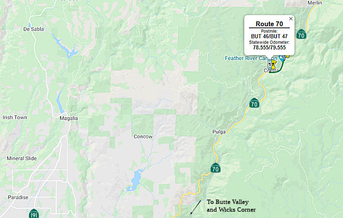 In January 2018, the CTC added the following project to
the SHOPP: 03-But-70 46.0/47.0. Route 70 Near Paradise, from 0.8 mile west
to 0.2 mile east of Shady Rest Area. Restore and repair damaged roadway by
raising the existing vertical alignment by approximately five feet and
protecting the embankment against future flooding with Rock Slope
Protection (RSP) or a retaining structure. PA&ED Allocated at
$1,700,000. Other phases not authorized yet. PA&ED: 10/11/2019. R/W:
11/10/2020. RTL: 12/05/2020. BC: 06/05/2021.
In January 2018, the CTC added the following project to
the SHOPP: 03-But-70 46.0/47.0. Route 70 Near Paradise, from 0.8 mile west
to 0.2 mile east of Shady Rest Area. Restore and repair damaged roadway by
raising the existing vertical alignment by approximately five feet and
protecting the embankment against future flooding with Rock Slope
Protection (RSP) or a retaining structure. PA&ED Allocated at
$1,700,000. Other phases not authorized yet. PA&ED: 10/11/2019. R/W:
11/10/2020. RTL: 12/05/2020. BC: 06/05/2021.
(Source: CTC Agenda, January 2018, Agenda Item
2.1a(1))
The 2020 SHOPP, approved in May 2020, included the
following Major Damage Restoration item of interest (carried over from the
2018 SHOPP): 03-Butte-70 46.0/47.0 PPNO 2293 Proj ID 0318000012 EA 3H540.
Route 70 Near Paradise, from 0.8 mile west to 0.2 mile east of Shady Rest
Area. Restore and repair damaged roadway by raising the existing vertical
alignment by approximately five feet and protecting the embankment against
future flooding with Rock Slope Protection (RSP) or a retaining structure.
Programmed in FY20-21, with construction scheduled to start in March 2021.
Total project cost is $58,866K, with $45,966K being capital (const and
right of way) and $12,900K being support (engineering, environmental,
etc.),
(Source: 2020 Approved SHOPP a/o May 2020)
In January 2021, the CTC approved for future
consideration of funding 03-But-70, PM 46.0/47.0 Pulga Profile Change
Project. Raise existing roadway profile approximately 5 feet on
Route 70 in Butte County. (MND) (PPNO 2293) (SHOPP) The project is located
on Route 70 on the east bank North Fork Feather River within the Feather
River Canyon in eastern Butte County approximately 4.3 miles northeast of
the town of Pulga and 25 miles northeast of Oroville. This project
proposes to improve a damaged section of roadway on Route 70 by raising
the existing roadway profile in the project limits approximately 5 feet,
replacing the Bear Creek Bridge, protecting the embankment with Rock Slope
Protection, and placing an earth retaining structure against future flood
damage. This project is fully funded and is currently programmed in the
2020 SHOPP for a total of $58,866,000 which includes Construction (capital
and support) and Right of Way (capital and support). Construction is
estimated to begin in 2022. The scope, as described for the preferred
alternative, is consistent with the project scope programmed by the
Commission in the 2020 SHOPP. A Mitigated Negative Declaration (MND) has
been completed. The project will result in less than significant impacts
to the environment after mitigation. The following resource areas may be
impacted by the project: wetland and other waters, biological resources,
and cultural resources. Avoidance and minimization measures will reduce
any potential effects on the environment. These measures include, but are
not limited to, the purchase of mitigation bank credits or offsite
permittee responsible mitigation for waters and wetlands, rehabilitation
of approximately 0.04 acres of creek channel and bank for biological
resources, and the production of a short film documenting the evolution of
the Feather River Canyon for cultural resources.
(Source: January 2021 CTC Agenda, Agenda Item
2.2c.(1))
In May 2021, the CTC approved the following
pre-construction support phase allocation(s): (2a) #3. $4,200,000
(PS&E); $400,000 (R/W Sup). 03-But-70 46.0/47.0. PPNO 03-2293; ProjID
0318000012; EA 3H540. Route 70 Near Paradise, from 0.8 mile west to 0.2
mile east of Shady Rest Area. Restore and repair damaged roadway by
raising the existing vertical alignment by approximately five feet and
protecting the embankment against future flooding with Rock Slope
Protection (RSP) or a retaining structure. (Future consideration of
funding approved under Resolution E-21-03; January 2021.) (Eleven month
time extension for PS&E and R/W Sup approved under Waiver 20-31; June
2020.) Prog. year 20-21.
(Source: May 2021 CTC Agenda, Agenda Item 2.5b.(2a)
#3)
In June 2022, the CTC approved the following
construction phase allocation: $36,660,000. 03-But-70 46.0/47.0. PPNO
03-2293: ProjID 0318000012; EA 3H540. Route 70 Near Paradise, from 0.8
mile west to 0.2 mile east of Shady Rest Area. Outcome/Output: Restore and
repair damaged roadway by raising the existing vertical alignment by
approximately five feet and protecting the embankment against future
flooding with Rock Slope Protection (RSP) or a retaining structure.
Allocation: CON ENG $6,600,000; CONST $43,846,000.
(Source: June 2022 CTC Agenda, Agenda Item
2.5b.(5))
In August 2022, the CTC approved the following
amendment to the SHOPP: 03-But-70 46.0/47.0. PPNO 03-2293; ProjID
0318000012; EA 3H540. Route 70 Near Paradise, from 0.8 mile west to 0.2
mile east of Shady Rest Area. Restore and repair damaged roadway by
raising the existing vertical alignment by approximately five feet and
protecting the embankment against future flooding with a soldier pile
retaining wall, replace Bear Creek Bridge, and construct concrete
barrier.. Allocation ($ × 1,000): PA&ED $0; PS&E $0; R/W Sup
$0; Con Sup $5,000; R/W Cap $1,371; Const Cap $31,230; TOTAL $37,601.
Begin Const: 12/14/2022. Concurrent CONST and CON ENG allocation under
Resolution FP-22-10; August 2022. So what changed here? Note that the
previous iterations had "protecting the embankment against future flooding
with Rock Slope Protection (RSP) or a retaining structure". The updated
amendment has a soldier pile retaining wall.
(Source: August 2022 CTC Agenda, Agenda Item
2.1a.(1a) #2)
In August 2022, the CTC approved the following
construction phase allocation: $36,230,000. 03-But-70 46.0/47.0. PPNO
03-2293; ProjID 0318000012; EA 3H540. Route 70 Near Paradise, from 0.8
mile west to 0.2 mile east of Shady Rest Area. Outcome/Output:
Restore and repair damaged roadway by raising the existing vertical
alignment by approximately five feet and protecting the embankment against
future flooding with a soldier pile retaining wall, replace Bear Creek
Bridge, and construct concrete barrier. Programmed Allocation: CON ENG
$5,000,000; CONST $31,230,000. CEQA - MND, 12/7/2020; Re-validation
5/9/2022. NEPA - FONSI, 4/6/2022; Re-validation 5/9/2022. Future
consideration of funding approved under Resolution E-21-03; January 2021.
As part of this allocation request, the Department is requesting to extend
the completion of CONST and CON ENG an additional 12 months beyond the 36
month deadline. Concurrent Amendment under SHOPP Amendment 22H-003; August
2022.
(Source: August 2022 CTC Agenda, Agenda Item
2.5b.(1) #12)
In August 2018, the CTC approved $2,731,000 in SHOPP funding for Plumas
02-Plu-70 11.5/11.9: Route 70 Near Belden, from 2.1 miles to 1.6 miles
west of Chipps Creek Bridge. Outcome/Output: Improve safety by realigning
roadway curves, widening shoulders, adding new guardrail, and constructing
a gabion-style retaining wall. This project will reduce the number and
severity of collisions.
(Source: August 2018 CTC Agenda Item 2.5f.(3) Item
5)
In March 2015, the CTC approved for future consideration of funding a project in Plumas County near Quincy that will replace the existing Yellow Creek Bridge (070 PLU 14.90) and construct retaining walls, slope protection, guardrails, and other improvements. The project is programmed in the 2014 State Highway Operation and Protection Program (SHOPP). The total estimated cost is $13,420,000 for capital and support. Construction is estimated to begin in Fiscal Year 2016-17. The scope, as described for the preferred alternative, is consistent with the project scope programmed by the Commission in the 2014 SHOPP.
Spanish Creek Bridge (070 PLU 35.32)
 In March 2006, the CTC considered a plan to replace an existing bridge near Keddie. This project is fully
funded in the 2006 State Highway Operation and Protection Program (SHOPP).
The total estimated project cost is $42,040,000. Construction is estimated
to begin in Fiscal Year 2009-10. There are three alternatives:
In March 2006, the CTC considered a plan to replace an existing bridge near Keddie. This project is fully
funded in the 2006 State Highway Operation and Protection Program (SHOPP).
The total estimated project cost is $42,040,000. Construction is estimated
to begin in Fiscal Year 2009-10. There are three alternatives:
In March 2009, the CTC approved for future consideration of funding a project to replace the existing Spanish Creek Bridge (070 PLU 35.32) and construct roadway improvements north of the city of Quincy. The project is programmed in the 2008 State Highway Operation and Protection Program. The total estimated project cost is $58,064,000, capital and support. Construction is estimated to begin in Fiscal Year 2009-10.
In January 2018, the CTC approved for future consideration of funding a
project on Route 70 (02-But-70, PM 42.06/42.21/46.44, 02-Plu-70, PM
23.67/31.82) in Butte and Plumas Counties: Construct fish passages at five
tributaries along Route 70 in Butte and Plumas Counties. The project
involves improvement of aquatic organism passage at five tributaries in
Butte and Plumas Counties to the Feather River along Route 70. The five
locations that are tributaries to the Feather River are Mill Creek, Bear
Creek, Rush Creek, Soda Creek and an unnamed tributary. The project is
fully funded by District 2 Minor A and United States Forest Service for an
estimated $12.7 million. Construction is estimated to begin in Fiscal Year
2019-20. The scope, as described for the preferred alternative, is
consistent with the project scope programmed by the Commission in the 2016
State Highway Operation and Protection Program (SHOPP).
(Source: CTC Agenda, January 2018, Agenda Item
2.2c(1))
Spring Garden Bridge
In August 2015, the CTC approved for future consideration of funding a project in Plumas County that will rehabilitate and widen the Spring Garden Bridge (070 PLU 51.21) near the town of Quincy. The project is programmed in the 2014 State Highway Operation and Protection Program. The total estimated cost is $17,670,000 for capital and support. Construction is estimated to begin in Fiscal Year 2015-16. The scope, as described for the preferred alternative, is consistent with the project scope programmed by the Commission in the 2014 State Highway Operation and Protection Program.
In August 2016, the CTC approved $13,545,000 for Plumas 02-Plu-70 50.6/51.7. Route 70 near Quincy, from 0.6 mile west to 0.5 mile east of Spring Garden Bridge Overhead No. 09-0062 (070 PLU 51.21). Outcome/Output: Rehabilitate the existing structure by replacing the bridge deck, widening to make shoulders standard, retrofitting the sub-structure, and installing standard bridge rail.
In October 2017, it was reported that in Spring 2017,
Plumas County residents encountered a traffic signal at the Spring Garden
Bridge, 5 miles east of Quincy, that interrupted a normally fluid drive.
It is quiet on top of the bridge, and if it weren’t for the signal
and the extensive roadwork caution signs, commuters would probably never
guess that underneath the 50-year-old bridge is a flurry of activity. The
$10.2 million bridge rehabilitation project has been in the California
Department of Transportation’s repair lineup for about six to seven
years and is estimated to take about two years, 1,200 cubic yards of
concrete, and 600,000 pounds of steel to complete. Because there are no
alternate routes and the bridge has to remain functional for traffic, the
project had to be divided into five stages. With the help of MCM
Construction Inc. from Sacramento, the bridge is already in Stage 2 of the
process. The piers that hold up the bridge are lined with a massive amount
of lumber and falsework (temporary construction) that will be removed when
the project is done. The crew is made up of 12 to 30 construction workers
a day who have filled walls with thousands of pounds of concrete and
widened the bents that hold the deck. The result will be a 16-foot wider
bridge, with a higher friction surface that should reduce the accident
rate on the roadway, updated railing and even a new bike lane. The project
will pause for winter 2017 and the signal will be removed until weather
permits the crew to start work again next spring. The next phase of work
will then begin: repairing the deck, which will entail a complete
replacement of the girders, supports and road surface, making one-way
traffic a must.
(Source: Plumas News, 10/13/2017)
PPNO 3703 Feather River Inn (02-Plu-70, PM 58.2/R78.4, 65.8/R66.2)
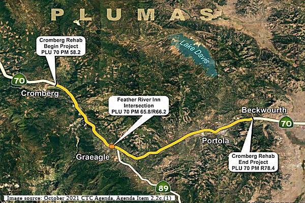 The 2018 STIP, approved at the CTC March 2018 meeting, appears to allocate $330K for PPNO 3703 Feather River Inn, intersection improvements (~ PLU
R66.073), with the bulk of the work being done in FY21-22. The project
scope is defined as a new road connection, in Plumas County near Blairsden
from 0.4 mile east of Little Bear Road to 0.4 mile west of Route 89.
The 2018 STIP, approved at the CTC March 2018 meeting, appears to allocate $330K for PPNO 3703 Feather River Inn, intersection improvements (~ PLU
R66.073), with the bulk of the work being done in FY21-22. The project
scope is defined as a new road connection, in Plumas County near Blairsden
from 0.4 mile east of Little Bear Road to 0.4 mile west of Route 89.
In March 2020, the CTC approved the 2020 STIP, which
continued the programmed funding for PPNO 3703 Feather River Inn,
intersection improvements.
(Source: March 2020 CTC Agenda, Item 4.7, 2020 STIP
Adopted 3/25/2020)
In May 2021, the CTC received notice that Caltrans
proposes to delay construction (CON) on the Feather River Inn Intersection
Improvement project (PPNO 3703) in Plumas County. The proposal notes that
$200,000 in STIP Regional Improvement Program funds are programmed to
support and capital for the CON phase of the Feather River Inn
Intersection Improvement Project (PPNO 3703) in Fiscal Year 2021-22. The
project limits for the Feather River Inn Intersection Improvement project
lie within the project limits of the State Highway Operation and
Protection Program (SHOPP) funded Cromberg Rehabilitation project (PPNO
3619). To benefit from the economies of scale, and to minimize traffic
impacts to the travelling public, both projects are planned to be combined
into a single construction contract. A value analysis completed for the
Cromberg Rehabilitation project recommended that all non-standard
horizontal and vertical curves be improved. This curve improvement work,
along with the identification of several additional culverts needing
improvements, resulted in additional environmental studies, design work
and right of way requirements. This additional effort has delayed all
major delivery milestones for the Cromberg Rehabilitation project.
Therefore, Caltrans is requesting to delay the CON phase of the Feather
River Inn Intersection Improvement project (PPNO 3703) from 2021-22 to
2022-23 so that both STIP and SHOPP projects can still be delivered as a
single construction contract. This STIP amendment was approved at the June
2021 CTC meeting.
(Source: May 2021 CTC Agenda, Agenda Item
2.1b.(12); June 2021 CTC Agenda, Agenda Item 2.1a.(14))
In October 2021, the CTC approved the following project
for future consideration of funding: 02-Plu-70, PM 58.2/R78.4, 65.8/R66.2.
Cromberg Rehabilitation & Feather River Inn Intersection. Rehabilitate
pavement, drainage, and make other improvements on approximately 20 miles
of Route 70 in Plumas County. (MND) (PPNO 3619) (SHOPP) (Related Item
under Ref. 2.5b.(2)) This project is located on Route 70 between the
communities of Cromberg and Portola, in Plumas County. The Department
proposes to reconstruct the roadway and add 4 to 8-foot shoulders. In
addition, it proposes to rehabilitate the roadway, repair or replace
culverts, upgrade the guardrail, upgrade bridge railing at Humbug Creek
Bridge, and make pedestrian facilities compliant with the Americans with
Disabilities Act. This project is currently programmed in the 2020 State
Highway Operation and Protection Program (SHOPP) for a total of
$105,761,000, of which, $97,620,000 is currently through G-13 Contingency
which includes Construction (capital and support). Construction is
estimated to begin in 2022-23. The scope, as described for the preferred
alternative, is consistent with the project scope as programmed by the
Commission in the 2020 SHOPP.A copy of the MND has been provided to
Commission staff. The project will result in less than significant impacts
to the environment after mitigation.
(Source: October 2021 CTC Agenda, Agenda Item
2.2c.(1))
In January 2023, the CTC approved an allocation request
for $108,120,000 for the SHOPP Roadway Rehabilitation project on Route 70,
in Plumas County, to advertise the project. This project is located on
Route 70 in and near Cromberg and Portola, from Gill Ranch Road to west of
the Big Grizzly Creek Bridge, in Plumas County (02-Plu-70 58.2/R78.4; PPNO
02-3619; ProjID 0216000024; EA 1H580). The project will rehabilitate the
roadway, rehabilitate and replace culverts, and upgrade guardrail, bridge
railing at Humbug Creek Bridge № 09-0022, and pedestrian facilities
to current standards. In March 2018, this project was programmed in the
SHOPP for $88,050,000 in Construction Capital and $6,810,000 in
Construction Support for allocation in Fiscal Year 2021-22. In May 2021,
the project was amended to modify the scope and revise the programmed
amount to $90,810,000 in Construction Capital. In June 2022, the project
received a 9-month allocation time extension for the construction phase.
In October 2022, the project was amended to program the unfunded G-13
Contingency construction phases for $90,810,000 in Construction Capital
and $6,810,000 in Construction Support. In October 2022, the
Engineer’s Estimate (EE) reflected the need of $99,040,000 in
Construction Capital (9.1 percent over the programmed amount) and
$9,080,000 in Construction Support (33.3 percent over the programmed
amount). If this request is approved, the Department plans to advertise
the project in February 2023, and begin construction in June 2023.
Construction is planned for three construction seasons for a duration of
360 working days. The Construction Capital and Support estimates are
greater than the programmed amount due to the increase in quantities and
unit price for earthwork and hot mix asphalt and the number of working
days needed for the project.
(Source: January 2023 CTC Agenda, Agenda Item 2.5d.(1))
In January 2023, the CTC approved the following STIP
allocation: $220,000. 02-Plu-70 65.8/R66.2. PPNO 02-3703; ProjID
0218000025; EA 3H740. Feather River Inn Intersection Improvement. Route 70
In Plumas County near Blairsden from 0.4 mile east of Little Bear Road to
0.4 mile west of Route 89. New road connection. CEQA - MND, 08/31/2021;
Re-validation 11/21/2022. NEPA - CE, 08/31/2021; Re-validation 11/21/2022.
Right of Way Certification: 06/29/2022. Future consideration of funding
approved under Resolution E-21-88; October 2021. RIP RW savings, $17,000
to be credited to Plumus RIP Shares. CON ENG $50,000; CONST $170,000.
(Source: January 2023 CTC Agenda, Agenda Item 2.5c.(1) #1)
In June 2025, it was reported that the stretch of Route 70 that runs through Portola between Green Street and Second Street is
getting an update. The roadway will be repaved and repainted. New striping
will reduce through lanes from four to two, create new bike lanes with a
buffer zone, widen the turn lanes and realign the traffic signals —
all while maintaining current parking. The work is part of Caltrans’
“Cromberg Combined” project, which covers about 16 miles of
Route 70 in eastern Plumas County, from Cromberg to just past Portola. The
$101 million project encompasses a variety of roadway improvements:
Recycling and replacing old pavement, widening shoulders to current
standards, replacing guard rail, and replacing or installing drainage
systems and culverts. The work, begun in 2024, is expected to be completed
by 2026.
(Source: Plumas Sun, 6/5/2025)
In December 2025, it was reported that the plan to
"calm" traffic in Portola will be implemented during the 2026 construction
season. When contractors laid new pavement on that section of the road in
fall 2025, they installed temporary lane markers that appeared to maintain
the previous four-lane configuration, leading some residents to speculate
that plans for bike lanes and other enhancements had been scrapped. This
was because the plan presented in April 2025 would retain a center turn
lane and parking on both sides of the road, but would reduce the number of
through traffic lanes from four to two and add separated bike lanes on
both sides. CalTrans subsequently confirmed that the proposal to
reconfigure the traffic pattern through Portola “is going to happen
as planned,” but will be implemented in the 2026 construction season
when related safety elements are in place.
(Source: Mountain Messenger, 12/10/2025)
In December 2014, the CTC authorized relinquishment of right of way in the county of Plumas along Route 70 at 0.6 miles west of Grizzly Road (apx 070 PLU R78.759), consisting of collateral facilities. The County, by resolution dated April 16, 2013, waived the 90-day notice requirement and agreed to accept title upon relinquishment by the State.
NamingNote: The "Named Freeways, Highways, Structures and Other Appurtenances in California" document indicates that the Farm-to-Fork Corridor is along Route 70; however, the actual naming resolution designates the corridor as bieng along Route 99, from TEH 20.400 at Eldrid Avenue near the community of Dairyville to TEH 24.529 near Arch Street in the City of Red Bluff in the County of Tehama. Reference: Assembly Concurrent Resolution (ACR) 27, Res. Chapter 109, Statutes of 2021, 09/07/21.
The portion of Route 20 from YUB 0.000 to YUB R3.389 and Route 70 from YUB 13.604 to YUB 15.850 in the City of Marysville in the County of Yuba is designated as part of the National Purple Heart Trail. The resolution designating these segments noted that the Marysville Veterans Memorial Center is located on the west side of Route 70 in the City of Marysville and is the home of the Marysville Veterans of Foreign Wars Post 948 and the Veterans Memorial Wall for Purple Heart Recipients, Veterans, and Honoring Pearl Harbor. It also noted that the historic Marysville Cemetery is located on the east side of Route 70 in the City of Marysville and is the final resting place of approximately 104 veterans, some of whom are Purple Heart recipients, from all wars fought by the United States beginning with the Mexican-American War. Lastly, it noted that the Marysville Veterans of Foreign Wars Post 948 wished to continue the National Purple Heart Trail through the City of Marysville on Route 20 and Route 70; and that Senior Vice Commander Brock Bowen of the Marysville Veterans of Foreign Wars Post 948 took the initiative to bring the National Purple Heart Trail through the City of Marysville. Designed by Assembly Resolution ACR 19, Res. Chapter 106, Statutes of 2021, on September 7, 2021
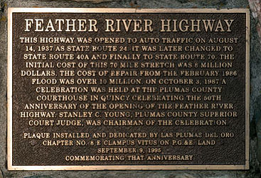 The portion of this route from Oroville (~ BUT 13.236) to Quincy (~ PLU
R43.256R) was historically named the "Feather River Highway". A
plaque was installed in September 1995 that reads: "This highway was
opened to auto traffic on August 14, 1937 as State Route 24. It was later
changed to State Route 40A and finally to State Route 70. The initial cost
of this 70 mile stretch was 8 million dollars. The cost of repair from the
February 1986 flood was over 10 million. On October 3, 1987 a celebration
was held at the Plumas County Courthouse in Quincy celebrating the 50th
anniversary of the opening of the Feather River Highway. Stanley C. Young,
Plumas County Superior Court Judge was chairman of the celebration."
The portion of this route from Oroville (~ BUT 13.236) to Quincy (~ PLU
R43.256R) was historically named the "Feather River Highway". A
plaque was installed in September 1995 that reads: "This highway was
opened to auto traffic on August 14, 1937 as State Route 24. It was later
changed to State Route 40A and finally to State Route 70. The initial cost
of this 70 mile stretch was 8 million dollars. The cost of repair from the
February 1986 flood was over 10 million. On October 3, 1987 a celebration
was held at the Plumas County Courthouse in Quincy celebrating the 50th
anniversary of the opening of the Feather River Highway. Stanley C. Young,
Plumas County Superior Court Judge was chairman of the celebration."
(Image source: NoeHill Travels)
The portion of this route from Pacific Heights/Georgia Pacific Way to the westbound ramp of Garden Drive (~ BUT 12.498 to BUT 16.622) is named the "Post No. 1747 Veterans of Foreign Wars of the United States Memorial Highway". This section of Route 70 runs near the Headquarters of Post No. 1747; the naming was in honor of the 100th Anniversary of the Veterans of Foreign Wars of the United States, and the 70th Anniversary of Post No. 1747 in Oroville. Named by Assembly Concurrent Resolution 149, Chapter 97, July 12, 2000.
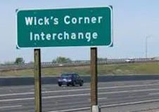 The junction between Route 70 and
Route 149 near the City of Oroville (~ BUT R20.643R), in the County of
Butte, is named the "Wick's Corner Interchange". This segment was
named in memory of Moses Wick, born in Ohio in 1822. Moses Wick served in
the Mexican War under the command of General Zachary Taylor, who
eventually became President of the United States. In 1852, Moses Wick
moved to California with his wife Maria in a wagon train pulled by his
team of oxen on a journey that took six months. The land in the area of
the current cloverleaf junction between Route 70 and Route 149 was deeded
in 1852 to Moses Wick as a reward for his military service. On September
3, 1852, Moses Wick made a homestead of the 160 acre territory and began
raising cattle as a pioneer cattle rancher. Through purchases and other
land grants, he eventually owned about 800 acres adjacent to "Wick's
Corner". Wick made a modest living as a butcher by selling and supplying
beef to gold miners and merchants in the area. He also used his faithful
team of oxen to haul freight and cargo back and forth to the mines between
Oroville and Sacramento. Moses Wick died in 1888 at the age of 66 years
and was survived by his second wife Roxie Ann, his son Charles, and
daughter Ella Wick Crum. He cattle ranch was operated until his son
Charles sold most of the ranch to Senator Thomas Rockhill in 1906 for
$25,000. The cattle ranch became a tavern and an early stagecoach stop for
the Central Pacific Railroad. Although Wick's historic home was demolished
in 1947, this area continues to be known as "Wick's Corner". The modern
Route 70 was constructed in the 1960s when the former highway was
submerged beneath the rising waters of Lake Oroville. Mrs. Merle
McAndrews, the great granddaughter of both Moses Wick and Senator Thomas
Rockhill, still lives on the property in a portion of one of the original
ranches that was built more than 70 years ago. Named by Assembly
Concurrent Resolution (ACR) 39, Resolution Chapter 71, on 7/3/2007.
The junction between Route 70 and
Route 149 near the City of Oroville (~ BUT R20.643R), in the County of
Butte, is named the "Wick's Corner Interchange". This segment was
named in memory of Moses Wick, born in Ohio in 1822. Moses Wick served in
the Mexican War under the command of General Zachary Taylor, who
eventually became President of the United States. In 1852, Moses Wick
moved to California with his wife Maria in a wagon train pulled by his
team of oxen on a journey that took six months. The land in the area of
the current cloverleaf junction between Route 70 and Route 149 was deeded
in 1852 to Moses Wick as a reward for his military service. On September
3, 1852, Moses Wick made a homestead of the 160 acre territory and began
raising cattle as a pioneer cattle rancher. Through purchases and other
land grants, he eventually owned about 800 acres adjacent to "Wick's
Corner". Wick made a modest living as a butcher by selling and supplying
beef to gold miners and merchants in the area. He also used his faithful
team of oxen to haul freight and cargo back and forth to the mines between
Oroville and Sacramento. Moses Wick died in 1888 at the age of 66 years
and was survived by his second wife Roxie Ann, his son Charles, and
daughter Ella Wick Crum. He cattle ranch was operated until his son
Charles sold most of the ranch to Senator Thomas Rockhill in 1906 for
$25,000. The cattle ranch became a tavern and an early stagecoach stop for
the Central Pacific Railroad. Although Wick's historic home was demolished
in 1947, this area continues to be known as "Wick's Corner". The modern
Route 70 was constructed in the 1960s when the former highway was
submerged beneath the rising waters of Lake Oroville. Mrs. Merle
McAndrews, the great granddaughter of both Moses Wick and Senator Thomas
Rockhill, still lives on the property in a portion of one of the original
ranches that was built more than 70 years ago. Named by Assembly
Concurrent Resolution (ACR) 39, Resolution Chapter 71, on 7/3/2007.
(Image sources: Enterprise Record)
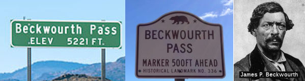 Beckwourth Pass (LAS 0) is named for James P. Beckwourth, a frontiersman who was born
in Virginia and traveled to California in 1844. There have been various
spellings of his name. He is credited with discovering the pass that bears
his name in 1850. It soon became an important immigrant route, crossing
Plumas and Butte Counties, and ending in Marysville. Beckwourth built a
home in Sierra Valley in 1852 and set up a trading post. In the course of
time, the pass was used by the Western Pacific Railroad. A tunnel goes
under the actual pass. Railroad surveyors succeeded in plotting the
crossing of the Sierra without ever exceeding a one percent grade. To
achieve that, they prescribed a loop near the hamlet of Spring Garden.
Beckwourth Pass (LAS 0) is named for James P. Beckwourth, a frontiersman who was born
in Virginia and traveled to California in 1844. There have been various
spellings of his name. He is credited with discovering the pass that bears
his name in 1850. It soon became an important immigrant route, crossing
Plumas and Butte Counties, and ending in Marysville. Beckwourth built a
home in Sierra Valley in 1852 and set up a trading post. In the course of
time, the pass was used by the Western Pacific Railroad. A tunnel goes
under the actual pass. Railroad surveyors succeeded in plotting the
crossing of the Sierra without ever exceeding a one percent grade. To
achieve that, they prescribed a loop near the hamlet of Spring Garden.
(Source: Bill Sanford "Getting out of the Central
Valley: Highway passes to the east" (emailed draft 10/1/2010); Image
source: NoeHill Travels in California; California Historical Landmarks; Colorado Virtual Library)
 Named Structures
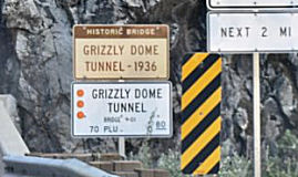 Tunnel 09-0001 (PLU 000.73), in Plumas county near Tobin, is named the "Grizzly Dome Tunnel". It was built in
1936. Grizzly Dome Tunnel is one of three tunnels built by the Works
Progress Administration (WPA) along the Feather River Highway in northeast
California. The tunnels were the final pieces in the construction of the
Feather River highway (Route 70) by the State of California (1928-37).
Tunnel 09-0001 (PLU 000.73), in Plumas county near Tobin, is named the "Grizzly Dome Tunnel". It was built in
1936. Grizzly Dome Tunnel is one of three tunnels built by the Works
Progress Administration (WPA) along the Feather River Highway in northeast
California. The tunnels were the final pieces in the construction of the
Feather River highway (Route 70) by the State of California (1928-37).
(Image source: The Living New Deal)
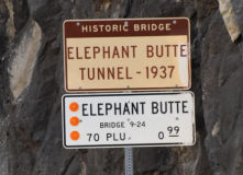 Tunnel 09-0024 (PLU 000.99) in Plumas county is named the "Elephant Butte Tunnel". It was built in 1937,
and was named through historical and long usage. Elephant Butte Tunnel is
one of three tunnels blasted through granite by Works Progress
Administration (WPA) workers along the Feather River Highway (present
highway 70) in northeast California. The tunnels were the final pieces in
the construction of the Feather River highway by the State of California
(1928-37). Elephant Butte tunnel is the northern-most tunnel of the three.
The tunnels were blasted through solid granite in and around Grizzly Dome.
Rock from the tunnels was used for rock safety walls along the highway.
Tunnel 09-0024 (PLU 000.99) in Plumas county is named the "Elephant Butte Tunnel". It was built in 1937,
and was named through historical and long usage. Elephant Butte Tunnel is
one of three tunnels blasted through granite by Works Progress
Administration (WPA) workers along the Feather River Highway (present
highway 70) in northeast California. The tunnels were the final pieces in
the construction of the Feather River highway by the State of California
(1928-37). Elephant Butte tunnel is the northern-most tunnel of the three.
The tunnels were blasted through solid granite in and around Grizzly Dome.
Rock from the tunnels was used for rock safety walls along the highway.
(Image and information source: The Living New Deal)
This route also has the following Safety Roadside Rest Areas:
 Massack, in Plumas County, 6.5 mi E of Quincy. (PLU 49.736)
 Lester T. Davis, in Plumas County, 3 mi E of Portola. It was named after Lester T. Davis, a member of the
California State Assembly from 1946 to 1952, when he died in office.
(PLU R79.144)
Lester T. Davis, in Plumas County, 3 mi E of Portola. It was named after Lester T. Davis, a member of the
California State Assembly from 1946 to 1952, when he died in office.
(PLU R79.144) Historical Route
Assembly Concurrent Resolution 180, 1998, designated those portions of US 40 that are still publically maintained and not already designated as part of Historic US 40 as "Historic US 40".
Senate Concurrent Resolution 66, Chaptered May 18, 2006 (Resolution Chapter 51), designated, upon application by an appropriate local governmental agency, any section of former Alternate U.S. Highway Route 40 that is still a publicly maintained highway and that is of interest to the applicant, as Historic Alternate U.S. Highway Route 40. This recognizes the role that Former Alternate U.S. Highway Route 40 played in the development of the transportation routes into California over what is now known as the Davis "Y". Alternate U.S. Highway Route 40 is currently Route 113 from Davis to Woodland and Yuba City, and Route 70 through Marysville, Oroville, and the Feather River Canyon to Hallelujah Junction on Route 395, a route that today serves 27 towns and the six counties of Yolo, Sutter, Yuba, Butte, Plumas, and Lassen. The Feather River Scenic Byway is a 130 mile segment of Route 70, which was part of Alternate U.S. Highway Route 40.
 Exit Information
 Other WWW Links
Post-1964 State Route 70: Route 99 to US 395
1936-1964 US 70: Los Angeles to Arizona
 Scenic Route
[SHC 263.4] Post 1964 Route 70: From Route 149 near Wicks Corner to Route 89 near Blairsden.
Although this Route 70 is eligible for Scenic Highway status, it has not yet met the criteria to be officially designated as Scenic Highway.
Freeway[SHC 253.1] Post-1964 Route 70: Entire route. Added to the Freeway and Expressway system in 1959. This is constructed to freeway standards in segment (1) from Olivehurst to Marysville; and in segment (2) from Route 162 to Route 149.
 Statistics
Overall statistics for Route 70:
Blue Star Memorial HighwayRoute 70 is designated a Blue Star Memorial Highway between Marysville and Hallelujah Junction. The marker is located at the roadside rest stop by the Feather River in Belden. Designated by Assembly Concurrent Resolution 150, Chapter 98, July 12, 2000.
 Interregional Route
 National Trails
 US 70 was part of the Southern National Highway.
 US 70 was part of the Atlantic-Pacific Highway.
 Pre-1964 Legislative Route
The route that became LRN 70 was first defined in 1925, by Chapter 351 which directed the commission “...to transfer and convey unto the State of California that certain road situate in the said county of Mendocino and described as follows: Commencing at a point on the state highway 2446 ft from the S boundary of the town limits of the town of Ukiah city and running thence in an E-ly direction along the course of the right of way of the present county road to the W line of the grounds of the Mendocino State Hospital...” In 1935, LRN 70 was codified as:
"[LRN 1] near Ukiah to the west line of the grounds of the Mendocino State Hospital"
This definition remained until 1963. It is present-day unsigned Route 222.
© 1996-2024 Daniel P. Faigin.
Maintained by: Daniel P. Faigin
<webmaster@cahighways.org>.
 Route 69
 Route 71